
GeoUML a conceptual data model for geographical data conformant to ISO TC 211
Upload
truongdangCategory
view
216download
0
ISO/TC 211 N 2705
2009-05-15
Number of pages: 47
ISO/TC 211 Geographic information/Geomatics
ISO reference number: 19150
Title: Report from stage 0 Project 19150 Geographic information - Ontology
Source: ISO/TC 211/WG 7/PT 19150
Expected action: For information and consideration at the 28th ISO/TC 211 plenary meeting in Molde, Norway, 2009-05-28/29.
Type of document: Report
Hyperlink: http://www.isotc211.org/protdoc/211n2705/
ISO/TC 211 Secretariat
Telephone: + 47 67 83 86 71 Telefax: + 47 67 83 86 01
Standards Norway Strandveien 18 P.O. Box 242 NO-1326 Lysaker, Norway
E-mail: [email protected] URL: http://www.isotc211.org/
ISO TC 211/SC N Date: 2009-02-02
ISO/
ISO TC 211/SC /WG 7
Secretariat: SN
Geographic information — Ontology — Project 19150 - Preliminary stage (00.60) Information géographique — Ontologie — Projet 19150 - Stade préliminaire (00.60)
Warning
This document is not an ISO International Standard. It is distributed for review and comment. It is subject to change without notice and may not be referred to as an International Standard.
Recipients of this draft are invited to submit, with their comments, notification of any relevant patent rights of which they are aware and to provide supporting documentation.

ISO/
© ISO 2009 – All rights reserved ii
Copyright notice
This ISO document is a Draft International Standard and is copyright-protected by ISO. Except as permitted under the applicable laws of the user's country, neither this ISO draft nor any extract from it may be reproduced, stored in a retrieval system or transmitted in any form or by any means, electronic, photocopying, recording or otherwise, without prior written permission being secured.
Requests for permission to reproduce should be addressed to either ISO at the address below or ISO's member body in the country of the requester.
ISO copyright office Case postale 56 • CH-1211 Geneva 20 Tel. + 41 22 749 01 11 Fax + 41 22 749 09 47 E-mail [email protected] Web www.iso.org
Reproduction may be subject to royalty payments or a licensing agreement.
Violators may be prosecuted.

ISO/
© ISO 2009 – All rights reserved iii
Contents Page
Foreword .............................................................................................................................................................v Introduction........................................................................................................................................................vi 1 Scope......................................................................................................................................................1 2 Symbols and abbreviated terms ..........................................................................................................2 3 Semantic Web for interoperability of geographic information .........................................................3 3.1 The current Web situation ....................................................................................................................3 3.2 The Semantic Web.................................................................................................................................3 3.3 The geospatial Semantic Web..............................................................................................................8 4 The purpose of ontologies ...................................................................................................................9 4.1 Ontology.................................................................................................................................................9 4.2 Interoperability and reasoning with ontology ..................................................................................10 4.3 Context .................................................................................................................................................11 4.4 Definition of ontology in the context of ISO/TC 211 ........................................................................11 5 Values of ontologies and Semantic Web in the context of ISO/TC 211 .........................................12 6 Issues of relevance for ISO/TC 211 ...................................................................................................13 7 Related ISO/TC 211 works ..................................................................................................................14 8 From UML to OWL...............................................................................................................................16 8.1 Why OWL? ...........................................................................................................................................16 8.2 Conversion of ISO/TC 211 UML models to OWL ontologies...........................................................17 9 ISO19101 – Reference model .............................................................................................................22 10 ISO19103 – Conceptual schema language .......................................................................................23 11 Tools and methods for developing ontologies ................................................................................24 12 Addressing geographic information content through ontologies .................................................25 13 Interpretation, reasoning, and inference...........................................................................................26 13.1 Interpretation .......................................................................................................................................26 13.2 Reasoning and inference....................................................................................................................27 14 Semantic Web and Web services ......................................................................................................28 15 Conclusion ...........................................................................................................................................30 16 Recommendations ..............................................................................................................................31 17 Bibliography.........................................................................................................................................32 Annex A UML2OWL Conversion.....................................................................................................................34 A.1 UML class diagram..............................................................................................................................34 A.2 Semantic Web ......................................................................................................................................34 A.3 Ontologies and Semantic Web in ISO/TC 211 ..................................................................................34 A.4 Rules for OWL ontologies ..................................................................................................................34 A.5 UML package to OWL ontology .........................................................................................................35 A.6 UML class to OWL class.....................................................................................................................35 A.7 UML stereotype and abstract class ...................................................................................................35 A.8 UML ownedAttribute to owl:DatatypeProperty, owl:ObjectProperty, rdfs:domain,
rdfs:range.............................................................................................................................................36 A.9 UML multiplicity to OWL property restriction ..................................................................................36 A.10 UML enumeration and code list to owl:oneOf..................................................................................36 A.11 UML subclass, generalization to rdfs:subClassOf ..........................................................................37 A.12 UML association and roles to owl:ObjectProperty, rdfs:domain, rdfs:range ...............................37
ISO/
© ISO 2009 – All rights reserved iv
A.13 UML aggregation and composition to owl:ObjectProperty, owl:TransitiveProperty, rdfs:domain, rdfs:range......................................................................................................................38
Annex B List of contributions .........................................................................................................................40

ISO/
© ISO 2009 – All rights reserved v
Foreword
ISO (the International Organization for Standardization) is a worldwide federation of national standards bodies (ISO member bodies). The work of preparing International Standards is normally carried out through ISO technical committees. Each member body interested in a subject for which a technical committee has been established has the right to be represented on that committee. International organizations, governmental and non-governmental, in liaison with ISO, also take part in the work. ISO collaborates closely with the International Electrotechnical Commission (IEC) on all matters of electrotechnical standardization.
International Standards are drafted in accordance with the rules given in the ISO/IEC Directives, Part 2.
The main task of technical committees is to prepare International Standards. Draft International Standards adopted by the technical committees are circulated to the member bodies for voting. Publication as an International Standard requires approval by at least 75 % of the member bodies casting a vote.
In exceptional circumstances, when a technical committee has collected data of a different kind from that which is normally published as an International Standard (“state of the art”, for example), it may decide by a simple majority vote of its participating members to publish a Technical Report. A Technical Report is entirely informative in nature and does not have to be reviewed until the data it provides are considered to be no longer valid or useful.
ISO/RS 19150 was prepared by Technical Committee ISO/TC 211, Geographic information/Geomatics.

ISO/
© ISO 2009 – All rights reserved vi
Introduction
In 1994, the technical committee 211 initiated works to develop a family of international standards about geographic information. Standards in geographic information have been required to support the understanding and usage of geographic information, to increase the availability, the access, the integration, and the sharing of geographic information, and also to support the establishment of geospatial infrastructures at local, regional and global level. In other words, standards in geographic information became an underpinning for enabling interoperability of geospatially enabled computer systems and data.
During the last 15 years, base standards have been developed to structure the description and representation of geographic information from the definition of a reference model (ISO/TC 211 2002a). Spatial and temporal primitives are defined to structure the description of geometry, topology (ISO/TC 211 2003a; ISO/TC 211 2007f), and time (ISO/TC 211 2002b). Rules are delineated to define application schemas homogeneously (ISO/TC 211 2005a). A methodology to catalogue features defines the elements and the structure to document geographic features and their semantics (ISO/TC 211 2005b). The description of coordinate reference systems is standardized (ISO/TC 211 2007a) and an official international registry (ISO/TC 211 2005g) will be in place. Also, geographic features can be described spatially in an indirect manner using geographic identifiers (ISO/TC 211 2003b). Geographic information can be reported through metadata (ISO/TC 211 2003c) including among others the description of quality (ISO/TC 211 2002c; ISO/TC 211 2003c; ISO/TC 211 2006). A methodology for the encoding of geographic information (ISO/TC 211 2005c) with encoding standards (ISO/TC 211 2007e; ISO/TC 211 2007g) are defined. Now, data products can be specified (ISO/TC 211 2007b) based on the suites of ISO19100 standards. Service interfaces are specified for the Web (ISO/TC 211 2005d; ISO/TC 211 2005e). The foundation for location-based services for navigation is set (ISO/TC 211 2005f; ISO/TC 211 2007c; ISO/TC 211 2007d). Now, standardization in geographic information has reached a high level of structure in terms of data which, consequently, simplify largely the sharing and the use of geographic information. ISO19100 standards provide a significant contribution to support the direct access from the Internet and the Web. However, same geographic features may still be described differently according to the specific context from which they are abstracted making difficult to benefit from the richness of the various representations. As such, the semantic issue needs to be addressed more rigorously in the ISO19100 suites of standards to improve the interoperability of geographic information.
During that period, the Web has also progressed significantly towards the Semantic Web (or Web 3.0) to move from a Web of documents to a Web of data. The Web could be seen as a tremendous worldwide open database (Sycara et al. 2005) that people can query from their own perspective, understanding, or abstraction of real world phenomena or events and get accurate, detailed, and appropriate answers likewise people communicate between each other. This approach involves reasoning capabilities based on knowledge bases, i.e. ontologies. These advances become a very challenging opportunity in the geographic information realm to layout the next generation of standards in order to benefit from the Semantic Web to meet ISO/TC 211 objectives in achieving interoperability of geographic information.
The goal of this preliminary stage report is to expose the findings of the project team on how the Semantic Web can benefit to ISO/TC 211 in achieving interoperability of geographic information and what standardization activity would be required.
Accordingly, this report provides an overview of the Semantic Web and an explanation of ontology. It identifies the values of Semantic Web and ontologies and the issues of relevance for ISO/TC 211. It inventories the ISO/TC 211 related works. The report continues with a discussion of the purpose of OWL. It addresses the revision of the ISO/TC 211 reference model and the conceptual schema language. Semantic Web tools are listed. The question of standardizing geographic information content within ISO/TC 211 is discussed. The topic of interpretation and reasoning is reviewed. The topic of Semantic Web Services is addressed before concluding remarks and recommendations are enounced.

ISO/
© ISO 2009 – All rights reserved 1
Geographic information — Ontology — Project 19150 - Preliminary stage (00.60)
1 Scope
In May 2006, at the ISO/TC 211 plenary meeting, ISO/TC 211 has agreed to explore ontologies and the Semantic Wed in its resolution 347 on ontology:
"ISO/TC 211 invites Dr. Jean Brodeur of the NB of Canada to cooperate with the secretariat to draft a new work item proposal for a stage 00.60 project investigating how ontology and semantic web approaches can benefit ISO/TC 211 objectives."
This project aims at identifying how the concept of ontology and the Semantic Web can support and facilitate the work of ISO/TC 211 as well as how ISO/TC 211 may contribute to the Semantic Web in the perspective of improving the interoperability of geographic information. The project intends also to investigate the translation of some UML models into OWL and other structure for ontology.
Consequently, the scope of this preliminary stage project was stated as following:
Preliminary work (stage 0) to collect and compile information, and to investigate how ontology and semantic web approaches can benefit ISO/TC 211 objectives. At the end of this work, recommendations will be provided to the committee for further actions.
Recommendations will be provided to the technical committee for further actions in this area.
ISO/
© ISO 2009 – All rights reserved 2
2 Symbols and abbreviated terms
CIRIS Critical Infrastructure Response Information System
DAML DARPA Agent Markup Language
DL Description Logic
DTD Document Type Definition
LCCS Land Cover Classification System
LADM Land Administration Domain Model
OCL Object Constraint Language
ODM Ontology Definition Metamodel
OIL Ontology Inference Layer
OWL Web Ontology Language
OWL-S Semantic Markup for Web Services
PDF Portable document format
RDF Resource description framework
RDF-S RDF schema
RIF Rule interchange format
SPARQL Simple Protocol and RDF Query Language
UML Unified Modeling Language
URI Uniform Resource Identifier
W3C World Wide Web Consortium
XML Extensible markup language
WSMO Web Service Modeling Ontology
ISO/
© ISO 2009 – All rights reserved 3
3 Semantic Web for interoperability of geographic information
3.1 The current Web situation
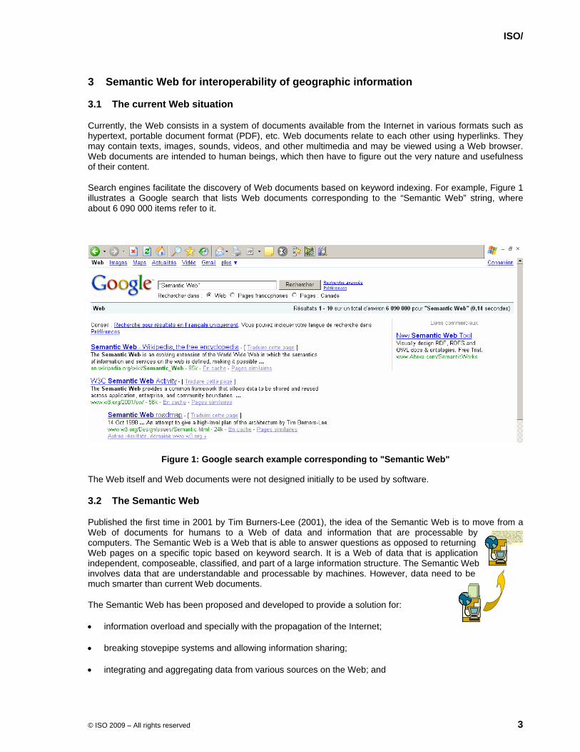
Currently, the Web consists in a system of documents available from the Internet in various formats such as hypertext, portable document format (PDF), etc. Web documents relate to each other using hyperlinks. They may contain texts, images, sounds, videos, and other multimedia and may be viewed using a Web browser. Web documents are intended to human beings, which then have to figure out the very nature and usefulness of their content.
Search engines facilitate the discovery of Web documents based on keyword indexing. For example, Figure 1 illustrates a Google search that lists Web documents corresponding to the “Semantic Web” string, where about 6 090 000 items refer to it.
Figure 1: Google search example corresponding to "Semantic Web"
The Web itself and Web documents were not designed initially to be used by software.
3.2 The Semantic Web
Published the first time in 2001 by Tim Burners-Lee (2001), the idea of the Semantic Web is to move from a Web of documents for humans to a Web of data and information that are processable by computers. The Semantic Web is a Web that is able to answer questions as opposed to returning Web pages on a specific topic based on keyword search. It is a Web of data that is application independent, composeable, classified, and part of a large information structure. The Semantic Web involves data that are understandable and processable by machines. However, data need to be much smarter than current Web documents.
The Semantic Web has been proposed and developed to provide a solution for:
• information overload and specially with the propagation of the Internet;
• breaking stovepipe systems and allowing information sharing;
• integrating and aggregating data from various sources on the Web; and
ISO/
© ISO 2009 – All rights reserved 4
• enabling users to retrieve the data they need more efficiently based on their own vocabulary (or concepts) and the specific vocabulary (concepts) used to described data.
The Semantic Web deals with common formats. The syntactic foundation of the Semantic Web is the extensible markup language (XML). Languages such as resource description framework (RDF), RDF schema (RDF-S), Web ontology language (OWL), rule interchange format (RIF), simple protocol and RDF query language (SPARQL) have been derived from XML.
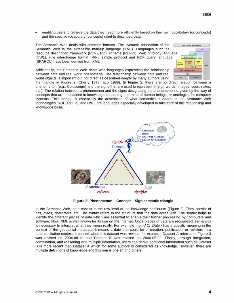
Additionally, the Semantic Web deals with languages expressing the relationship between data and real world phenomena. The relationship between data and real world objects is important but not direct as described deeply by many authors using the triangle in Figure 2 (Cherry 1978; Eco 1988). In Figure 2, there are no direct relation between a phenomenon (e.g., Colosseum) and the signs that are used to represent it (e.g., words, images, coordinates, etc.). The relation between a phenomenon and the signs designating the phenomenon is given by the way of concepts that are maintained in knowledge bases, e.g. the mind of human beings, or ontologies for computer systems. This triangle is essentially the description of what semantics is about. In the Semantic Web technologies, RDF, RDF-S, and OWL are languages especially developed to take care of this relationship and knowlwdge base.
Figure 2: Phenomenon – Concept – Sign semantic triangle
In the Semantic Web, data consist in the raw level of the knowledge continuum (Figure 3). They consist of bits, bytes, characters, etc. The syntax refers to the structure that the data agree with. The syntax helps to identify the different pieces of data which are essential to enable their further processing by computers and software. Now, XML is well known for its use on the Internet. Once pieces of data are recognized, semantics is necessary to interpret what they mean really. For example, <gmd:CI_Date> has a specific meaning in the context of the geospatial metadata; it means a date that could be of creation, publication, or revision. In a dataset citation context, it can tell when this dataset was revised, for example, Dataset A referred in Figure 3 was revised on 2004-08-12 and Dataset B was revised on 2006-05-22. Finally, through integration, combination, and reasoning with multiple information, users can derive additional information such as Dataset B is more recent than Dataset A which for some authors is considered as knowledge. However, there are multiple definitions of knowledge and this one is one among others.

ISO/
© ISO 2009 – All rights reserved 5
Figure 3: Knowledge continuum
Web services can also take advantage of the Semantic Web. Web services have brought additional functionalities on the Web by introducing distributed sofware resources conforming Web standards. However, theses services, each providing specific functionalities, need also to be discovered and their uses are often limited to groups of experts or a particular user community. The semantic description of Web services with ontologies can facilitate their discovery, invocation, interaction, and composition to enhance interoperability of Web services. Web services consist in important components of the Semantic Web since the Semantic Web is for data understandable and processable by machines, which may be Web services also. Web services and Semantic Web are well harmonized since they both adhere to common principles: URI, XML, and data.
Note: Web services will also be covered in Clause 14.
What Semantic Web requires to operate? At least five elements are needed to enable the Semantic Web:
• Logical assertions
• Classification of concepts
• Formal models
• Rules
• Trust
First, the Semantic Web requires logical assertions to associate a subject to an object with a verb. For example, the author of the map 44071-A1-TM-100 is the US Geological Survey. Second, classification of concepts such as taxonomies and ontologies (see clause 4) is required to define vocabularies. Third, formal models are essentials to define concepts, their properties, and relationships between concepts, which are fundamentals for reasoning. Fourth, rules are necessary for the derivation of conclusions by inference. Fifth, trust is deemed necessary in order to provide access to Semantic Web resources only to trusted agents. For instance, an agent can be asserted “trusted” from another via a digital signature.
Ontology is a fundamental notion in the Semantic Web. An ontology defines the meaning of data and describes it in a format that machines and applications can read. As such, an application using data has also access to their inherent semantics through the ontology associated to it. Therefore, ontologies can support integration of heterogenous data captured by different communities by relating them based on their semantic similarity.
The current World Wide Web Consortium (W3C) technologies supporting the Semantic Web are :
• RDF
• RDF-S
• OWL
DDaattaa
IInnffoorrmmaattiioonn
KKnnoowwlleeddggee
syntaxsemantics
Dataset B is more recent than Dataset A
Dataset B was revised on 2006-05-22 Dataset A was revised on 2004-08-12
Date information... xml
<gmd:CI_Date>...

ISO/
© ISO 2009 – All rights reserved 6
RDF is an XML-based language to represent information about specific resources or things that are found on the Web. Information are represented as a triple: Subject, Predicate and Object (Figure 4). The Subject is the resource or the thing about which something is asserted. The Predicate is the relation that binds the Subject to the Object. The Object is either a literal value describing the Subject or another resource referred to the Subject by the predicate.
Figure 4: The Subject, Predicate and Object triple
To continue our example in Figure 2, an RDF description of the location of the Colosseum in Rome may be presented as following:
<rdf:Description rdf:about="#Colosseum"> <ex:isLocatedIn> <rdf:Description rdf:about="#Rome"/> </ex:isLocatedIn> </rdf:Description>
Where:
#Colosseum is a Web resource corresponding to the subject
isLocatedIn is the predicate
#Rome is another Web resource corresponding to the object
Since Semantic Web is based on URI, any resource or thing would typically be identified by an URI.
RDF Schema (RDF-S) provides definitions of classes and properties that are required for the description of classes, properties and other resources. It is based on RDF. These RDF resources support the creation of application or user community specific RDF vocabularies and thus creating classes for specific data. Class instances can then be defined in RDF. RDF-S introduces relations between classes and instances as property.
Figure 5 illustrates an example using RDF-S language for the definition of the classes ISO19115, CitationAndResponsibleParty, and CI_Address where CI_Address is a subclass of CitationAndResponsibleParty, which CitationAndResponsibleParty is a a subclass of ISO19115. You can see also the definition of the property addressAdministrationArea that is of the type &rdfs;Literal and is associated to CI_Address.

ISO/
© ISO 2009 – All rights reserved 7
Figure 5: An ISO19115 RDF-S example
The Web Ontology Language (OWL) has been developed for the representation of knowledge. It consists of an evolution of the existing DAML+OIL (DAML: DARPA Agent Markup Language; OIL: Ontology Inference Layer). It is based on RDF and RDF-S. There are three level of expressivity in OWL from basic to rich:
1) Lite: intended mainly for the description of classification hierarchy with attributes, cardinalities are limited to 0 or 1;
2) DL: stands for description logics, add knowledge representation that improves reasoning, allows much flexibility on cardinality restrictions;
3) Full: allows maximum expressiveness and the syntactic freedom of RDF. As such a class may be either a collection of individuals or an individual in itself.
OWL consists in a fundamental piece for the Semantic Web.
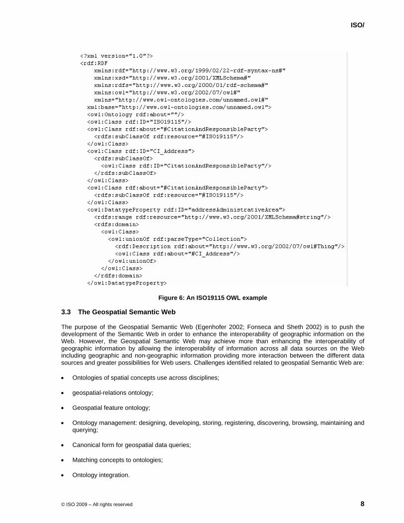
Figure 6 illustrates the same ISO19115 example as in Figure 5 using the OWL language for the definition of the classes ISO19115, CitationAndResponsibleParty, and CI_Address.
ISO/
© ISO 2009 – All rights reserved 8
Figure 6: An ISO19115 OWL example
3.3 The Geospatial Semantic Web
The purpose of the Geospatial Semantic Web (Egenhofer 2002; Fonseca and Sheth 2002) is to push the development of the Semantic Web in order to enhance the interoperability of geographic information on the Web. However, the Geospatial Semantic Web may achieve more than enhancing the interoperability of geographic information by allowing the interoperability of information across all data sources on the Web including geographic and non-geographic information providing more interaction between the different data sources and greater possibilities for Web users. Challenges identified related to geospatial Semantic Web are:
• Ontologies of spatial concepts use across disciplines;
• geospatial-relations ontology;
• Geospatial feature ontology;
• Ontology management: designing, developing, storing, registering, discovering, browsing, maintaining and querying;
• Canonical form for geospatial data queries;
• Matching concepts to ontologies;
• Ontology integration.

ISO/
© ISO 2009 – All rights reserved 9
4 The purpose of ontologies
The research in semantic interoperability has been very prolific on ontologies and related issues in the last decade to a point that it can be difficult to get a clear understanding of this notion. Moreover, ISO/TC 211 will need to be clear about its meaning within the context of international standardization in geographic information:
Taxonomy? XML schema?
Thesaurus? Conceptual model?
UML, RDF/S, OWL? Description logic?
Logical theory?
This section explores the nature of ontology, its purpose and role with respect to interoperability.
4.1 Ontology
Fundamentally, ontology refers in philosophy to the description of the world in itself (Peuquet et al. 1998); a model and an abstract theory of the world (Smith and Mark 1999); the science of being, of the type of entities, of properties, of categories, and relationships that are part of the reality (Bittner and Edwards 2001; Lehmann 1992). It is understood in philosophy that there is only one ontology.
More recently, the term "ontology" has been borrowed by the information technology and artificial intelligence communities and refers to “an explicit specification of a conceptualisation” (Gruber 1993) and a “logical theory accounting for the intended meaning of a formal vocabulary” (Guarino 1998). Information technology and artificial intelligence consider that reality may be abstracted differently depending on the context from which “things” are perceived and, as such, recognize that multiple ontologies about the same part of reality may exist.
As illustrated by Daconta et al. (2003) in Figure 7, there are several ways to formalise an ontology from weak to strong semantics. It is interesting to note that ISO/TC 211 has adopted the Unified Modeling Language (UML) class diagram to formalize classes, properties, and relations for the description of geographic information, and UML is relatively high in the Daconta's spectrum. UML is an object oriented formalism that was defined mainly for the design and development of systems, software, and database specifications. Although, it was not meant for ontologies, it is also used for the specification of taxonomies, classifications, and description of concepts as in ISO/TC 211. Consequently, ISO/TC 211 UML models can be considered ontologies even if they were not intended as such explicitly. However, UML was neither meant to be machine processable in a generic manner, although it supports the development of software in programming in some languages, nor meant to support the definition of concepts for a Web of data as OWL does for the Semantic Web.
Ontologies may be developed at different levels. At least three levels are widely recognized: global or top-level, domain, and application ontology. A global or top-level ontology defines general concepts that are independent from a specific domain, for instance the concept of space or time. A domain ontology defines concepts that are specific to a body of knowledge (e.g. geographic information, transportation, geology, land cover). An application ontology defines concepts that are specialised within a given context or a specific usage (e.g. parcel delivery, ambulance dispatching, and rescue). Level of ontologies are related in a way that it is possible to navigate between ontologies of the same level as well as from application to domain and then global ontologies, and conversely.

ISO/
© ISO 2009 – All rights reserved 10
Figure 7: The spectrum of possibilities to develop ontologies (from Daconta, M. et al., 2003. The semantic web, Wiley)
Figure 8: Levels of ontologies
4.2 Interoperability and reasoning with ontology
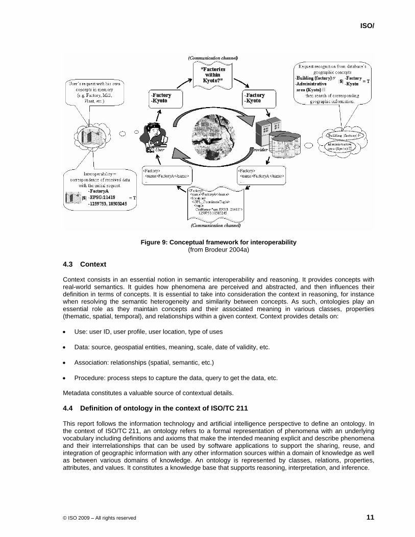
Figure 9 illustrates interoperability of geographic information in terms of an interpersonal communication process (Brodeur et al. 2003), in which a user agent requests geographic information about some aspects of the reality to a provider agent which respond back with some data. These two agents can be thought as machines or applications. What is important to note here is that the two agents have their own ontology to which they refer for interpretation, reasoning, and inference. This is possible through the formalization of concepts and relations between them, for example:
• Subsumption (isA, isSuperclassOf)
• Meronymy (part of)
• Assessment of semantic similarity between geographic concept (GeoSemantic proximity, matching distance, etc.)
ISO/
© ISO 2009 – All rights reserved 11
Figure 9: Conceptual framework for interoperability (from Brodeur 2004a)
4.3 Context
Context consists in an essential notion in semantic interoperability and reasoning. It provides concepts with real-world semantics. It guides how phenomena are perceived and abstracted, and then influences their definition in terms of concepts. It is essential to take into consideration the context in reasoning, for instance when resolving the semantic heterogeneity and similarity between concepts. As such, ontologies play an essential role as they maintain concepts and their associated meaning in various classes, properties (thematic, spatial, temporal), and relationships within a given context. Context provides details on:
• Use: user ID, user profile, user location, type of uses
• Data: source, geospatial entities, meaning, scale, date of validity, etc.
• Association: relationships (spatial, semantic, etc.)
• Procedure: process steps to capture the data, query to get the data, etc.
Metadata constitutes a valuable source of contextual details.
4.4 Definition of ontology in the context of ISO/TC 211
This report follows the information technology and artificial intelligence perspective to define an ontology. In the context of ISO/TC 211, an ontology refers to a formal representation of phenomena with an underlying vocabulary including definitions and axioms that make the intended meaning explicit and describe phenomena and their interrelationships that can be used by software applications to support the sharing, reuse, and integration of geographic information with any other information sources within a domain of knowledge as well as between various domains of knowledge. An ontology is represented by classes, relations, properties, attributes, and values. It constitutes a knowledge base that supports reasoning, interpretation, and inference.
ISO/
© ISO 2009 – All rights reserved 12
5 Values of ontologies and Semantic Web in the context of ISO/TC 211
According to the importance of ontology and Semantic Web for the purpose of geographic information interoperability, the following values of ontology and Semantic Web are recognized important with respect to ISO/TC 211 objectives:
1) Interoperability across domains;
2) Expose ISO/TC211 standards to other communities that are not aware of the spatial domain;
3) Automatic machine reasoning and inference;
4) From information description to knowledge description;
5) Focus on online access of information and knowledge (as opposed to offline access);
6) Interrelate similar/different concepts (such as different keywords for similar concepts in metadata);
7) Associate (similar/different) concepts between domains.
ISO/
© ISO 2009 – All rights reserved 13
6 Issues of relevance for ISO/TC 211
From the values of ontologies and Semantic Web identified in clause 5, a number of issues are identified relevant and of main importance for ISO/TC 211:
• Review of the reference model (ISO19101:2002)
• from information to knowledge, i.e. a new way to see information from a semantic perspective
• Develop rules for application ontologies
• Introduction of ontologies as part of product specification applications
• Developing content is becoming more and more an important issue with respect to ISO/TC 211
• Pragmatic orientation
• Development of top level ontologies which allow ontology mapping between domains
• Relationships with cross domain vocabularies
• Joint project with ISO/TC204 related GDF, to derive the road network application schema in an ontology structure
• Reasoning and inference
• Spatial operator in ISO19107:2003/ISO19125-1:2004, could they be defined and used as part of Semantic Web languages (RDF, RDF-S, and OWL)
• Semantic operators about the semantic similarity with respect to concepts, definition and use as part of Semantic Web languages (RDF, RDF-S, and OWL)
• Translation of ISO/TC 211 UML models in a Semantic Web language (ex. OWL)
• Investigate folksonomies
• Investigate tools and methodologies for developing ontologies
• Web services ontology
ISO/
© ISO 2009 – All rights reserved 14
7 Related ISO/TC 211 works
ISO/TC 211 shows similar objectives to the Semantic Web with respect to its scope, i.e. geographic information. The list below identifies ISO/TC 211 works related to ontologies and the Semantic Web:
• Terminology
• ISO19104: Terminology
• ISO19135: Procedures for registration of geographic information items
• ISO19127: Geodetic codes and parameters
• ISO19138: Data quality measures
• ISO19146: Cross domain vocabularies
• Content description
• ISO19109: Rules for application schema
• ISO19110: Feature cataloguing methodology
• ISO19126: Feature concept dictionaries and registers
• ISO19131: Data product specification
• Schemas
• ISO19103: Conceptual schema language
• ISO19107: Spatial schema
• ISO19108: Temporal schema
• ISO19115/-2/19: Metadata
• ISO19123: Schema for coverage geometry and functions
• ISO19125-1: Simple feature access - Common architecture
• Location-based services
• ISO19133: Tracking and navigation
• ISO19134: Multimodal routing and navigation
• ISO19141: Moving features
• Spatial referencing (Coordinate reference systems, geographic identifiers)
• Data quality principles
• Classification systems
• Common format (Encoding)
ISO/
© ISO 2009 – All rights reserved 15
• ISO19118 Encoding (rules)
• ISO19136 GML
• ISO19139 Metadata – XML Schema implementation
A more specific attention was given to the project ISO 19146 Geographic Information – Cross-Domain Vocabularies in order to clarify to what extent its scope (ISO 19146) do not overlap with this project (PT19150) scope on ontology and Semantic Web.
Essentially, ISO 19146 provides a set of rules and a register (ISO 19135) -based approach to set cross mapping between vocabularies. This approach support better understanding of vocabularies dealing with terms with or no equivalent definition and vice versa. The ISO 19146 approach takes also advantage of the structure of thesaurus. ISO 19146 does not intend to develop ontologies within geographic information, which is deemed necessary for geographic information interoperability on the Semantic Web.
Therefore, it is recognized that ISO 19146 makes a step forward for semantic interoperability. However because of its limited scope, this project does not intend to the full spectrum of semantic interoperability of geographic information. This project on ontologies and the Semantic Web therefore complements the work of ISO 19146.
ISO/
© ISO 2009 – All rights reserved 16
8 From UML to OWL
8.1 Why OWL?
Ontology is a fundamental component in the Semantic Web. It is an essential element for applications that search and merge information coming from many sources and communities. XML DTDs and Schemas allow the exchange of data between applications based on agreed definitions. However, the lack of semantics of those definitions disallows such possibilities with other XML definitions.
The Web Ontology Language (OWL) is the Semantic Web technological foundation for ontologies. There is no doubt that it is not possible to get any benefit from the Semantic Web if OWL is not part of the picture. The OWL allows formal descriptions of the semantics of classes and properties that are used in Web resources and as such machines can perform reasoning on these resources.
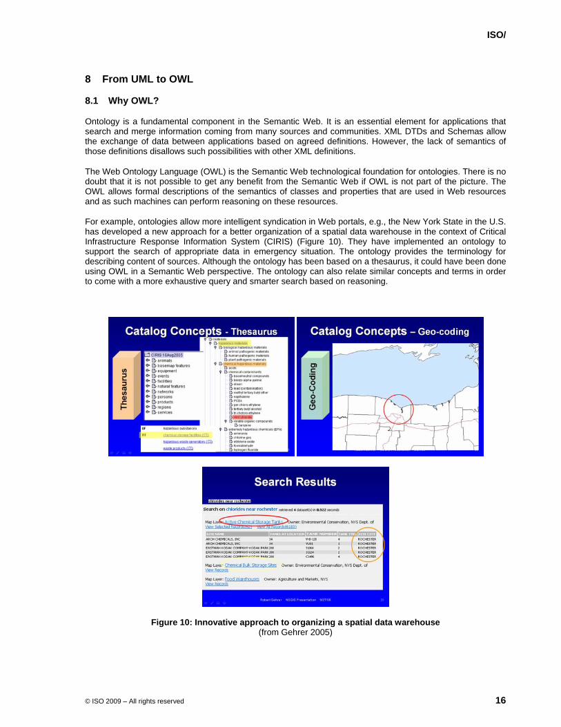
For example, ontologies allow more intelligent syndication in Web portals, e.g., the New York State in the U.S. has developed a new approach for a better organization of a spatial data warehouse in the context of Critical Infrastructure Response Information System (CIRIS) (Figure 10). They have implemented an ontology to support the search of appropriate data in emergency situation. The ontology provides the terminology for describing content of sources. Although the ontology has been based on a thesaurus, it could have been done using OWL in a Semantic Web perspective. The ontology can also relate similar concepts and terms in order to come with a more exhaustive query and smarter search based on reasoning.
Figure 10: Innovative approach to organizing a spatial data warehouse (from Gehrer 2005)

ISO/
© ISO 2009 – All rights reserved 17
Another typical benefit of OWL ontologies for the Web is the fact that users do not share the same vocabulary of resource authors as well as between authors within a common domain. Figure 11 shows different ways of expressing same geographic features from different topographical data sources.
NTDB1 VMap2 BC Digital Baseline Mapping (BCDBM)3
ON Digital Topographic
Database (ONDTD)4 BDTQ5
Information sur les terres et les eaux pour la
province du Nouveau-Brunswick6
- Waterbody - Watercourse - Irrigation Canal - Navigable Canal - Flooded area - Reservoir - Liquid
depot/dump
- Lake/Pond - Lake subject to
inundation - River/stream - Coastline/shoreline
- Coastline - Ditch - Flooded land - Lake - River/stream
- Flooded land - Lake - River/stream
- Canal - Cours d’eau - Lac - Mare
- Canal - Rivière–trait double - Lac (?) - Littoral (?) - Lac de rivière (?)
- Wetland - Marsh/swamp - Marsh - Swamp
- Marsh/Fen - Milieu humide (végétation)
- Marais de canneberge (?) - Marais (?)
- Road - Limited access
road
- Road - Car track
- Road - Accesway - Road
- Voie de communication
- Autoroute - Rue - Chemin - Route
- Artère (?) - Route collectrice (?) - Chemin local (?) - Chemin municipal (?) - Chemin d’accès aux
ressources naturelles (?) - Route en construction (?) - Rue (?)
- Vegetation - Trees - Orchard/plantation - Vineyard
- Wooded area - Vineyard - Orchard - Nursery
- Wooded area - Milieu boisé - Verger (aires
désignées)
- Clairière (?) - Bande défrichée (>100m)
(?) - Pépinière (?) - Verger (?) - Rangée d’arbres (>100m)
(?) - Zone boisée (>2m haut)
(?) - Railroad - Railroad
- Railroad siding/railroad spur
- RailLine - Rail line - Voie ferrée - Chemin de fer (?) - Triage de chemin de fer
(?) - Bridge - Obstacle to air
Navigation
- Bridge/overpass/viaduc (?)
- Bridge - Trestle
- Bridge (roadway)
- Bridge (railway) - Culvert
(roadway) - Culvert (railway)
- Pont - Pont
d’étagement
- Pont (?) - Ponceau (petit) (?)
Spatial pictogram descriptions: :0D ; :1D ; :2D ; ?:unknown geometry ; :multiple geometry ; :alternate geometry (see (Bédard, 1999b) and (Brodeur et al., 2000) for more details). (NaturalResources Canada, 1996); 2(VMap, 1995); 3(BC Ministry of Environment Lands and Parks (Geographic Data BC), 1992); 4(OBM, 1996); 5(Québec, 2000); 6(New Brunswick, 2000).Spatial pictogram descriptions: :0D ; :1D ; :2D ; ?:unknown geometry ; :multiple geometry ; :alternate geometry (see (Bédard, 1999b) and (Brodeur et al., 2000) for more details). (NaturalResources Canada, 1996); 2(VMap, 1995); 3(BC Ministry of Environment Lands and Parks (Geographic Data BC), 1992); 4(OBM, 1996); 5(Québec, 2000); 6(New Brunswick, 2000).
Figure 11: Geographic features abstracted differently from different topographical databases (from Brodeur et al. 2003)
Geographic information is expanding to a wide extent on the Web, dealing with large amount data. This situation becomes more and more problematic. Thus, having a specific ontology for each geographic databases along with concepts between all these ontologies interrelated to each others in OWL would support greatly the query and the translation of data from one vocabulary to another as well as the integration of data from various sources on the Web. With the OWL, reasoning on the Web becomes possible for systems and applications to find, integrate, and use the most appropriate geographic information for a given application. As such, software agents on the Web can understand and integrate information resources distributed on the Web, such as portals, service-specific sites, and the general Web.
8.2 Conversion of ISO/TC 211 UML models to OWL ontologies
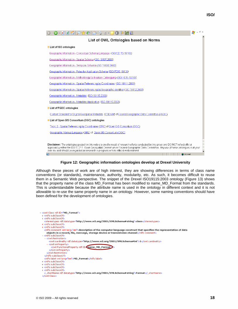
The availability of ISO/TC 211 –based work in OWL ontologies is not widespread on the Web. In fact, a few of them develop in a research perspective at Drexel University in Philadelphia and were available on the Web at http://loki.cae.drexel.edu/~wbs/ontology/list.htm until recently (Figure 12).
ISO/
© ISO 2009 – All rights reserved 18
Figure 12: Geographic information ontologies develop at Drexel University
Although these pieces of work are of high interest, they are showing differences in terms of class name conventions (or standards), maintenance, authority, modularity, etc. As such, it becomes difficult to reuse them in a Semantic Web perspective. The snippet of the Drexel ISO19115:2003 ontology (Figure 13) shows that the property name of the class MD_Format has been modified to name_MD_Format from the standards. This is understandable because the attribute name is used in the ontology in different context and it is not allowable to re-use the same property name in an ontology. However, some naming conventions should have been defined for the development of ontologies.

ISO/
© ISO 2009 – All rights reserved 19
Figure 13: Snippet of the Drexel ISO19115:2003 ontology
To be useful, ontologies must be coherent in terms of naming convention and modularity. They must also follow standards rigorously and as such must be maintained by an authoritative organization, in this case ISO/TC 211.
An experiment was conducted to investigate the translation of UML diagrams into OWL-DL. From that experiment, OWL-DL is identified the most appropriate profile to support interoperability for ISO/TC 211 purposes since knowledge representation is included for better reasoning and cardinality restrictions are more flexible. The additional flexibility of OWL Full, which allows to include user's constructs that are not standardized, might limit the interoperability of ontologies over the Web. The experience was based on ISO19115 – Metadata (Figure 14). As part of this experiment, an OWL-DL representation of the data types defined in ISO/TS 19103 – Conceptual schema language (Figure 15) was also developed to support the OWL representation of ISO19115.
Figure 14: Snippet of the ISO19115:2003 ontology experiment

ISO/
© ISO 2009 – All rights reserved 20
Figure 15: Snippet of the ISO19103:2005 ontology experiment
The experiment was not aimed to evaluate if the ISO/TC 211 UML models could be enhanced based on the full range of expressivity that OWL can provide. The experiment demonstrated that the ISO/TC 211 UML models can be translated in OWL with almost no lost of content and expressivity. However because of the flexibility and some limits of OWL compared to UML to express class, properties, and relations, the definition of rules and general orientations must be clarified to ensure consistency between the multiple ontologies that might come up from the conversion of ISO/TC 211 UML models into ISO/TC 211 OWL ontologies. Even if the experiment showed positive results, a number of questions still need clarifications:
• Methodology for translating UML diagrams to OWL ontologies is required
• OMG’s Ontology Definition Metamodel (ODM)
• Naming issues
• ISO/TC 211 use the same name in different context which is not authorised in ontologies, moreover in OWL
• UML diagrams are split into packages, how ontologies should be split? Standard, package
• Abstract class and stereotype have not equivalent notions in OWL? How should ISO/TC 211 implement them in OWL?
• There is no specific construct in OWL for aggregation and composition which are types of association. How should we specify them?
• Roles become properties in OWL but what about association names?
• Qualified associations, how should they be represented in OWL
ISO/
© ISO 2009 – All rights reserved 21
• Enumerations and code lists
• Operations and methods
• ontology quality assessment
• Enhancement of UML diagrams vs. OWL expressivity
• Precedence/coexistence of UML diagrams vs. Ontologies (OWL)
• Etc.
An exploratory work on these issues (presented in Annex A) proposes possible solutions. This work should be formalised and completed in a new work item in ISO/TC 211.
ISO/
© ISO 2009 – All rights reserved 22
9 ISO19101 – Reference model
A study of ISO19101:2002 Geographic Information – Reference Model was conducted in order to identify what can be enhanced in ISO19101:2002 to move forward from an information to a knowledge perspective and, thus, addressing semantics of geographic information more rigorously. The review of ISO19101:2002 Geographic Information – Reference Model becomes essential to address more clearly the issues of semantic interoperability of geographic information, ontology, and Semantic Web. From this study, questions or issues of relevance are:
• Introduce/clarify the role of Web related to interoperability of geographic information
• Introduce the idea of geographic information and knowledge and used it throughout the document
• New candidates for terms and definitions: knowledge, ontology, Web, Semantic Web, Reasoning, OWL, DL
• New candidates for symbols and abbreviations: XML, RDF, OWL, www/Web
• Geographic information services should introduce and address better the semantics of geographic information with the use of ontologies, as well as the access and encoding (e.g., OWL) of semantics.
• Clarify the relationship between the General Feature Model, application schema, and feature catalogue with ontology.
• Clause 6.4 revisits the definition of interoperability based on the communication framework and provides a more thorough integration of semantics including the role of ontologies and reasoning (Brodeur 2004; Brodeur et al. 2003).
• Revisit the definition of semantic interoperability (clause 6.4.2-f)
• Clarify in what terms ISO19103/CSL supports semantic interoperability (clause 6.4.3)
• Clarify the relationship between conceptual schema language and UML with OWL.
• Clause 7.2 should be revisited to integrate ontologies carefully. An additional purpose could be added as a third bullet “3) to allow knowledge representation for automatic reasoning and inference”
• Clause 7.4 should integrate the OWL ontology language
• Clause 7.5 and more specifically figure 4 should be reviewed to integrates ontology notions at the various levels
• Clause 7.7 should also be revisited to integrate ontologies carefully.
ISO/
© ISO 2009 – All rights reserved 23
10 ISO19103 – Conceptual schema language
ISO/TS 19103:2005 has adopted the Unified Modeling Language (UML) static structure diagram associated with the Object Constraint Language (OCL) and additional type definitions for developing computer-interpretable models, or schemas, in the context of geographic information. Such a language is deemed necessary to specify unambiguously geographic information and support its sharing. Thus, the schemas will serve as basis for the encoding and communication of geographic information. The choice and use of UML was appropriate when ISO/TC 211 initiated the standardization work since it was meant to support the design and development of systems, software, and databases. However, it is not machine processable in a generic manner to support the sharing, integration and reuse of information and, as such, schemas cannot be directly computer-interpretable.
Although ISO/TC 211 UML diagrams can be considered as ontologies in geographic information, they must be presented in a language that supports the Semantic Web for the sake of ISO/TC 211 to benefit from the Semantic Web. In light of the UML to OWL-DL conversion experiment and values and issues of relevance for ISO/TC 211, OWL shall be considered as an additional conceptual schema language in ISO/TC 211 for the description of concepts in geographic information, and therefore interoperability of geographic information will be in an excellent position to benefit from the Semantic Web.

ISO/
© ISO 2009 – All rights reserved 24
11 Tools and methods for developing ontologies
There are numerous open source and commercial tools available for developing, visualizing, using ontologies on the Semantic Web (ESW ; Herman 2008). They have been classified in the following manner:
• General Development Environments (SemanticWorks, Protégé, Jena, Redland, RDF Lib, RAP, Sesame, SWI-Prolog, TopBraid Composer, DOME, etc.)
• Editors (Protégé, GrOWL, Model Futures OWL Editor, TopBraid Composer, SemanticWorks, SWOOP, WSMO Studio, etc.)
• Content Management Systems (Cmap COE, Profium's Semantic Information Router, Talis Platform, etc)
• RDF Triple Store Systems (RDFStore, AllegroGraph, Tucana Suite, RDF Gateway, Mulgara, Jena SDB, D2R Server, SOR, OpenLink Virtuoso, Oracle Spatial 11g, Sesame, OWLIM, Tallis Platform, etc.)
• Programming Environments (Jena, OWL API, SESAME, RDF Lib, SemWen, SPARQL JavaScript Library, etc.)
• Reasoners (Pellet, RacerPro, KAON2, FaCT++, Ontobroker, ontotext, SHER, Oracle Spatial 11g, AllegroGraph, Wave, Cogito, etc.)
• Modularization and diffing tools (CEX, MEX, OWL Module Extractor, etc.)
• RDF Generators (Cypher, Open Calais, OpenLink Virtuoso, etc.)
• On-line Validators (W3C's RDF Validator, WonderWeb OWL-DL Validator, etc)
• SPARQL "Endpoints" (OpenLink Virtuoso, Talis Platform, etc.)
• Browsers (Disco, Protégé, Tabulator, Zitgist, OpenLink Data Explorer, BrowseRDF, Ontology Browser, etc.)
• Search Engines (Falcon, Sindice, AutoFocus, etc.)
• Converter (flickurl, TopBraid Composer, GRDDl, Triplr, jpeg2rdf, etc.)
• Tagging and Semantic Web Vocabularies (Moat, TextDigger, ontotext KIM, etc.)
• Semantic integration (Metatonix, ontotext ORDI, etc.)
However, technology is evolving rapidly in the Web Semantic realm and it is not possible to provide an up to date picture of it. A few Web sites are trying to provide this information and should be consulted for a more recent picture:
• The SemanticWebTools wiki at http://esw.w3.org/topic/SemanticWebTools
• The SemanticWeb.gr wiki at http://www.semanticweb.gr/index.php/Tools_and_Systems
• The W3C Multimedia Semantics Incubator Group wiki at http://www.w3.org/2005/Incubator/mmsem/wiki/Tools_and_Resources
• Description Logic Reasoners at http://owl.cs.manchester.ac.uk/reasoners.html
• The OWL at Manchester page at http://owl.cs.manchester.ac.uk/

ISO/
© ISO 2009 – All rights reserved 25
12 Addressing geographic information content through ontologies
Until recently, ISO/TC 211 focussed essentially on the standardization of structural and syntactical issues of geographic information. However, interoperability of geographic information goes beyond this. The semantic issues need more.
Recently, ISO/TC 211 has initiated works on content with the projects 19144-2 Geographic information - Classification Systems - Part 2: Land Cover Classification System LCCS, 19152 Geographic information - Land Administration Domain Model (LADM). Additionally, topics such as climate change variables, address are in the line of sight of ISO/TC 211.
The issue of standardizing geographic information content becomes more and more important with respect to ISO/TC 211 and geographic information interoperability. However, it is essential to keep a pragmatic orientation with respect to international standardization. Obviously, ISO/TC 211 cannot standardize all thematic aspects associated with geographic information in details; the world is dynamic; the perception and description of the world is subjective. However, the development of top-level ontologies might be an appropriate avenue in order to allow mapping of concepts between application ontologies within a given domain as well as interrelate concepts across domains. The development of such ontologies should be initiated from requirements by members. Nevertheless, top level ontologies should not duplicate works that is done in other specific communities but should benefit from these and should provide an international acceptance. In order to be beneficial to the various communities interacting on the Semantic Web and takes advantage of it, the ontologies shall be developed in OWL and made available in an ISO/TC 211 on-line ontology repository.
ISO/
© ISO 2009 – All rights reserved 26
13 Interpretation, reasoning, and inference
The Semantic Web developments allow new opportunities related to interoperability, i.e. interpretation of data elements, reasoning, and inference.
13.1 Interpretation
By providing meaning, ontologies can support software agents in the interpretation of incoming data elements. Software agents can assign a meaning automatically to incoming data elements, which could be assembled in queries or results from an operation performed by another process, based on the ontologies that constitute their knowledge base. Such a function, also called interpretation, is made possible by ontology matching or similarity assessment.
Ontology matching refers to the correspondence between semantically related entities of distinct ontologies (Euzenat and Shvaiko 2007). It aims at finding concepts and/or properties from different ontologies that are related together, such as equivalence, subsumption, and disjointness. Mapping of concepts and properties between ontologies is not a trivial function. Typically, one or more concepts from one ontology can map to one concept of another ontology, and conversely. A similarity assessment between concepts supports the mapping between concepts. The similarity assessment can be either quantitative or qualitative. In quantitative assessment, the similarity typically takes the form of a semantic distance between concepts and is expressed in the interval [0,1] where 0 means that the concepts are disjoint and 1, that the concepts are equivalent. Qualitative similarity assessment takes the form of predicates that specify the relation between two concepts, such as equal, include, overlap, etc.
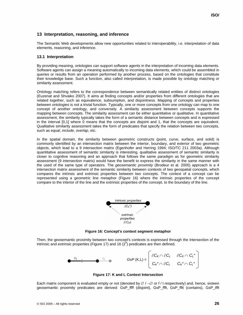
In the spatial domain, the similarity between geometric constructs (point, curve, surface, and solid) is commonly identified by an intersection matrix between the interior, boundary, and exterior of two geometric objects, which lead to a 9 intersection matrix (Egenhofer and Herring 1994; ISO/TC 211 2003a). Although quantitative assessment of semantic similarity is interesting, qualitative assessment of semantic similarity is closer to cognitive reasoning and an approach that follows the same paradigm as for geometric similarity assessment (9 intersection matrix) would have the benefit to express the similarity in the same manner with the used of the same type of operators. The geosemantic proximity (Brodeur et al. 2005) approach is a 4 intersection matrix assessment of the semantic similarity between contexts of two geospatial concepts, which compares the intrinsic and extrinsic properties between two concepts. The context of a concept can be represented using a geometric line metaphor (Figure 16) where the intrinsic properties of the concept compare to the interior of the line and the extrinsic properties of the concept, to the boundary of the line.
Figure 16: Concept's context segment metaphor
Then, the geosemantic proximity between two concept's contexts is expressed through the intersection of the intrinsic and extrinsic properties (Figure 17) and 16 (24) predicates are then defined.
GsP (K,L) =∂CK ∩ ∂CL ∂CK ∩ CL°
CK° ∩ ∂CL CK° ∩ CL°
Figure 17: K and L Context Intersection
Each matrix component is evaluated empty or not (denoted by ∅ / ¬∅ or f / t respectively) and, hence, sixteen geosemantic proximity predicates are derived: GsP_ffff (disjoint), GsP_ffft, GsP_fftt (contains), GsP_tfft

ISO/
© ISO 2009 – All rights reserved 27
(equal), GsP_ftft (inside), GsP_tftt (covers), GsP_ttft (coveredBy), GsP_fttt (overlap), GsP_tttt, GsP_tfff (meet), GsP_tftf, GsP_tttf, GsP_ttff, GsP_fttf, GsP_fftf, GsP_ftff.
13.2 Reasoning and inference
Reasoning is the process from which one draws inferences or conclusions. This is possible when data elements can be interpreted. Examples:
IF ontologyA:street ⊆ ontologyA:road
AND ontologyA:road = ontologyB:thoroughfare
THEN ontologyA:street ⊆ ontologyB:thoroughfare
IF ontologyA:watercourse contains (or GsP_fftt) ontologyB:river/stream
AND ontologyB:river/stream contains (or GsP_fftt) ontologyC:creek
THEN ontologyA:watercourse contains (or GsP_fftt) ontologyC:creek
IF Joe is passenger of Train 1234
AND Train 1234 goes to Rome
THEN Joe goes to Rome
Because ontologies provide the definitions of concepts and relationships between them using with respect to some context, reasoning and inference is then possible. Reasoning and inference can lead to a wide range of possibilities related to interoperability: data discovery, query answering, composition of geographic data from multiple sources, using data across domains, data integration and mashup, and so on.

ISO/
© ISO 2009 – All rights reserved 28
14 Semantic Web and Web services
So far, the Semantic Web is presented from a data perspective. However, the current Web goes beyond a Web of documents. Web services are also important components that compose the Web. Currently, the use and interaction of Web services still require the participation of humans to find and integrate Web services. The Semantic Web could also contribute to facilitate the interaction with Web Services by introducing semantics in Web Services (Sycara et al. 2005). Therefore, Semantic Web and ontologies concerns also Web services. Semantic Web can support Web services to automate the Web service discovery, the composition of Web services, their invocation in order to enable seamless machine interoperation with minimum human interaction. Semantic annotation of services in terms of capabilities, selection, access, composition, and invocation are then required and should be supported through ontologies.
Two frameworks are found to support the above functionalities: OWL-S – Semantic Markup for Web Services and WSMO – Web Service Modeling Ontology.
OWL-S is the response from the W3C to Web services. OWL-S, which was formerly known as DAML-S, is an ontology of services to support discovery, composition, and invocation of Web services. The structure of the ontology consists of three parts: service profile, process model, and grounding. The service profile provides details about what the service can do for clients, the capabilities. The main task of the profile is for advertising and discovering services. The service process model provides details about how the service operates. The grounding provides details about the manner to interact with a service via messages, such as transport protocols.
Figure 18: OWL-S service ontology (from World Wide Web Consortium 2004)
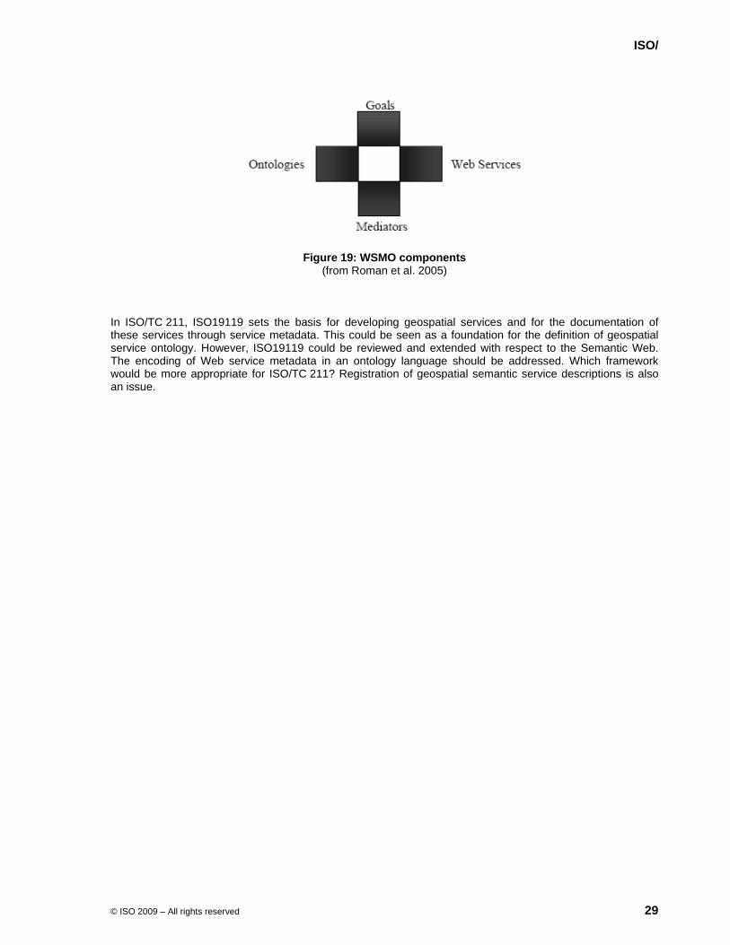
WSMO is the response on Web service from the European Semantic Systems Initiative. It is composed of 4 main elements: ontologies, Web services, goals, and mediators. The ontologies provide the formal specification of terminology used by the other WSMO components. The Web services provide the semantic description of Web services in terms of capabilities, interfaces, and internal operation of the service. Goals refer to the objectives that a client wants to achieve by using Web services. The mediators provide the connectors between components with mediation facilities for handling heterogeneities.
ISO/
© ISO 2009 – All rights reserved 29
Figure 19: WSMO components (from Roman et al. 2005)
In ISO/TC 211, ISO19119 sets the basis for developing geospatial services and for the documentation of these services through service metadata. This could be seen as a foundation for the definition of geospatial service ontology. However, ISO19119 could be reviewed and extended with respect to the Semantic Web. The encoding of Web service metadata in an ontology language should be addressed. Which framework would be more appropriate for ISO/TC 211? Registration of geospatial semantic service descriptions is also an issue.
ISO/
© ISO 2009 – All rights reserved 30
15 Conclusion
ISO/PT19150 was initiated to review the potential and benefit of ontologies and the Semantic Web to reach the objectives of ISO/TC 211 for the interoperability of geographic information. ISO/TC 211 has spent the last 15 years to establish a very robust structure for the description of geographic information. This structure is documented with harmonized UML models and covers a wide spectrum of topics with respect to geographic information. Although ISO/TC 211 UML models are very rich descriptions, they are not directly usable by machines to support interoperability of geographic information and their translation into specific software by human beings may not respect all the details of the models.
The Semantic Web brings a new vision and new Web technologies to make the Web information more interoperable by making them machine processable by the use of ontologies. Clause 3 has summarized the vision and technologies of the Semantic Web in order to set a common understanding of it.
The notion of ontology is an underpinning in the Semantic Web vision. In the Semantic Web perspective, an ontology provides the meaning of the data elements and Web services that are shared and accessible on the Web. Clause 4 has defined what ontologies are and described the role of ontologies with respect to interoperability and more specifically in the context of geographic information. Ontologies serve as knowledge bases for the interpretation data and reasoning with them.
Clause 5 of this report identifies values of ontologies and Semantic Web with regard to ISO/TC 211. Of primary importance, ontologies and Semantic Web aim to enable interoperability not only within the geographic information realm but across different disciplines. By adhering to the Semantic Web, geographic information interoperability would be much smarter and possible between different data sources. ISO/TC 211 standards would then reach a much wider community and support a broader variety of applications. It is important to note that the spatial domain is complex and the Semantic Web community requires the availability of spatial ontologies to support this type of information over the Web.
Clause 6 lists the issues of relevance for ISO/TC 211 with respect to Semantic Web and ontologies. Clause 7 lists ISO/TC 211 related works to the Semantic Web. It is important to recognize that adhering to the orientation of the Semantic Web requires revisiting the ISO/TC 211 reference model and ISO/TC 211 conceptual schema language. RDF and OWL languages are important pieces of technology of the Semantic Web and their used need to be addressed carefully in ISO/TC 211 (see Clause 8). Clauses 9 and 10 address these issues.
Clause 11 demonstrates that there is a wide range of technologies (commercial and Open Source) supporting the Semantic Web and it is constantly expanding. The Semantic Web and ontologies are now beyond a theoretical idea and have reached the status of a well developed technology.
Addressing geographic information content is a complex task. ISO/TC 211 has played a leading role in addressing the structure to document geographic information content. As described in Clause 12, ISO/TC 211 is required to play a more significant role in establishing high level ontologies which would support and enhance semantic interoperability.
Entering in the Semantic Web brings new opportunities for interoperability of geographic information. As discussed in Clause 13, automatic interpretation, reasoning, and inference will become possible on the Web.
The Web is also composed of Web services. The discovery, selection, access, composition, and invocation of Web services are also an issue of the Semantic Web. Clause 14 introduces frameworks to support Semantic Web services. The discussion on this issue must continue within ISO/TC 211 and a revision of ISO19119 might be required.
In light of the report and the discussion of the project team, ontologies and Semantic Web approaches can benefits to a great deal to the ISO/TC 211 objectives. However, it means that ISO/TC 211 adopt a new strategy to take advantage of it. This new strategy must be described within a revised reference model and shall adopt OWL-DL as an additional conceptual schema languages for the description of concepts defined within ISO/TC 211. The next Clause details the recommendations for further consideration by ISO/TC 211.
ISO/
© ISO 2009 – All rights reserved 31
16 Recommendations
16.1 Recommendation 1: Review of the ISO/TC 211 reference model
A review of ISO19101:2002 Geographic Information – Reference Model becomes essential to address more clearly the issues of semantic interoperability of geographic information, ontology, and Semantic Web. It is recommended to undertake this work as part of the systematic review of ISO19101:2002 (document N2386).
16.2 Recommendation 2: Cast ISO/TC 211 standards so they can benefit from and support the Semantic Web
b) OWL as complementary to UML: ISO/TC 211 shall recognize OWL-DL as a complementary language to UML for the description of ISO/TC 211 concepts to benefit from and support the Semantic Web.
c) OWL ontology rules: ISO/TC 211 shall initiate a new work item to elaborate rules for consistent derivation of OWL-DL ontologies from the ISO/TC 211 UML models for ISO19103, application schemas, and ISO/TC 211 other UML models. This work should consider the exploratory works presented in annex A. Conformance clauses shall be defined carefully to ensure the quality of the OWL-DL ontologies.
d) OWL-DL ontology derivation: ISO/TC 211 shall initiate the derivation of OWL-DL ontologies equivalent to ISO/TC 211 UML models using the rules in (b). Further, ISO/TC 211 shall make these OWL-DL ontologies freely available on the ISO/TC 211 Web site to support Semantic Web applications. Additionally, awareness of these ontologies shall be developed, so they should be posted on ontology registries (e.g. "swoogle“).
16.3 Recommendation 3: Developing content ontologies
ISO/TC 211 shall encourage high level content definition. This shall be done by the definition of high level ontologies. These high level ontologies would serve as a basic framework to define ontologies at greater level of details and will allow mapping of concepts between application ontologies within a given domain as well as interrelate concepts across domains. All content ontologies shall be accessible in OWL-DL and made accessible on the ISO/TC 211 Web site.
16.4 Recommendation 4: Service ontology
ISO/TC 211 shall initiate the revision of ISO19119:2005 geographic information - Services to enhance service metadata in order to support discovery of Web services on the Semantic Web. The work item shall decide which way would be preferable for ISO/TC 211 to describe Web Services: OWL-S, WSML, or another.
16.5 Recommendation 5: Semantic operators
ISO/TC 211 shall initiate a new work item to define semantic proximity operators between concepts associated with geometric and temporal representations. These operators will complement the current suites of geometric and temporal operators as defined in ISO19107:2003, ISO19108:2002, ISO19125-1:2004, and ISO19141:2008.
ISO/
© ISO 2009 – All rights reserved 32
17 Bibliography
Berners-Lee, T., J. Hendler, and O. Lassila, 2001, The Semantic Web. Scientific Am., pp. 34-43. Bittner, T., and G. Edwards, 2001, Toward an Ontology for Geomatics. Geomatica, 55, pp. 475-490. Brodeur, J., 2004a, A Communication Process Account of the Interoperability of Geographic Information. In
Proceedings of International Conference on Cybernetics and Information Technologies, Systems and Applications (CITSA 2004) (Orlando, Florida), pp. 63-68.
Brodeur, J., 2004b, Interoperability of Geographic Information: A Communication -Based Prototype. In Proceedings of The 8th World Multi-Conference on Systemics, Cybernetics and Informatics (SCI 2004) (Orlando, Florida), pp. 327-332.
Brodeur, J., Y. Bédard, G. Edwards, and B. Moulin, 2003, Revisiting the Concept of Geospatial Data Interoperability within the Scope of a Human Communication Process. Transactions in GIS, 7, pp. 243-265.
Brodeur, J., Y. Bédard, and B. Moulin, 2005, A Geosemantic Proximity -Based Prototype for Interoperability of Geospatial Data. Computer Environment and Urban Systems, 29, pp. 669-698.
Cherry, C., 1978, On Human Communication: a Review, a Survey, and a Criticism (The MIT Press). Daconta, M.C., L.J. Obrst, and K.T. Smith, 2003, The Semantic Web: A Guide to the Future of XML, Web
Services, and Knowledge Management (Wiley Publishing, Inc.). Eco, U., 1988, Sémiotique et philosophie du langage (Presses Universitaires de France). Egenhofer, M.J., 2002, Toward the Semantic Geospatial Web. Egenhofer, M.J., and J.R. Herring, 1994, Categorizing Binary Topological Relations Between Regions, Line
and Points in Geographic Databases. In The 9-Intersection: Formalism and Its Use for Natural-Language Spatial Predicates (Technical Report), edited by M. Egenhofer, D. M. Mark, and J. R. Herring: NCGIA), pp. 1-28.
ESW, ESW Wiki - SemanticWebTools, http://esw.w3.org/topic/SemanticWebTools Euzenat, J., and P. Shvaiko, 2007, Ontology Matching (Springer). Fensel, D., and C. Bussler, The Web Service Modeling Framework WSMF Extended Abstract. Fonseca, F., and A. Sheth, 2002, The Geospatial Semantic Web (White Paper), UCGIS. Gehrer, R., 2005, An Innovative Approach to Organizing a Spatial Data Warehouse. Gruber, T.R., 1993, Toward Principles for the Design of Ontologies Used for Knowledge SharingKSL 93-04,
Knowledge Systems Laboratory, Palo Alto, California. Guarino, N., 1998, Formal Ontology and Information Systems. In Proceedings of Formal Ontology in
Information Systems (FOIS '98) (Trento, Italy), pp. 3-15. Herman, I., 2008, State of the Semantic Web. IBM, and Sandpiper Software Inc., 2006, Ontology Definition Metamodel (ODM). ISO/TC 211, 2002a, ISO19101:2002 Geographic information - Reference model (International Organization
for Standardization). ISO/TC 211, 2002b, ISO19108:2002 Geographic information - Temporal schema (International Organization
for Standardization). ISO/TC 211, 2003a, ISO19107:2003 Geographic information - Spatial schema (International Organization for
Standardization). ISO/TC 211, 2003b, ISO19112:2003 Geographic Information - Spatial referencing by geographic identifier
(International Organization for Standardization). ISO/TC 211, 2003c, ISO19115:2003 Geographic Information - Metadata (International Organization for
Standardization). ISO/TC 211, 2005a, ISO19109:2005 Geographic information - Rules for application schema (International
Organization for Standardization). ISO/TC 211, 2005b, ISO19110:2005 Geographic Information - Methodology for feature cataloguing
(International Organization for Standardization). ISO/TC 211, 2005c, ISO19118:2005 Geographic information - Encoding (International Organization for
Standardization). ISO/TC 211, 2005d, ISO19119:2005 Geographic Information - Services (International Organization for
Standardization). ISO/TC 211, 2005e, ISO19128:2005 Geographic information - Web Map Server interface (International
Organization for Standardization). ISO/TC 211, 2005f, ISO19133:2005 Geographic information - Location-based services — Tracking and
navigation (International Organization for Standardization).

ISO/
© ISO 2009 – All rights reserved 33
ISO/TC 211, 2005g, ISOTS19127:2005 Geographic information - Geodetic codes and parameters (International Organization for Standardization).
ISO/TC 211, 2007a, ISO19111:2007 Geographic information - Spatial referencing by coordinates (International Organization for Standardization).
ISO/TC 211, 2007b, ISO19131:2007 Geographic information - Data product specification (International Organization for Standardization).
ISO/TC 211, 2007c, ISO19132:2007 Geographic information - Location-based services -- Reference model (International Organization for Standardization).
ISO/TC 211, 2007d, ISO19134:2007 Geographic information - Location-based services -- Multimodal routing and navigation (International Organization for Standardization).
ISO/TC 211, 2007e, ISO19136:2007 Geographic Information - Geography markup language (International Organization for Standardization).
ISO/TC 211, 2007f, ISO19137:2007 Geographic information - Core profile of the spatial schema (International Organization for Standardization).
ISO/TC 211, 2007g, ISO/TS19139 Geographic information - Metadata - XML schema implementation (International Organization for Standardization).
Lehmann, F., 1992, Semantic Networks. Computers and Mathematics with Applications, 23, pp. 50. O’Dea, D., S. Geoghegan, and C. Ekins, 2005, Dealing with Geospatial Information in the Semantic Web. In
Proceedings of Australasian Ontology Workshop (AOW 2005), pp. 69-73. Peuquet, D., B. Smith, and B. Brogaard, 1998, The Ontology of Fields. In Proceedings of Summer Assembly
of the University Consortium for Geographic Information Science (Bar Harbor, Maine). Probst, F., F. Gibotti, A. Pazos, M.A. Esbri, M. Benigno, M. Gutiérrez, and W. Kuhn, 2004, Connecting ISO
and OGC Models to the Semantic Web. Roman, D., U. Keller, H. Lausen, J. de Bruijn, L. Ruben, M. Stollberg, A. Polleres, C. Busseler, and D. Fensel,
2005, Web Service Modeling Ontology. Applied Ontology, pp. 77-106. Shadbolt, N., T. Berners-Lee, and W. Hall, 2006, The Semantic Web Revisited. Smith, B., and D. Mark, 1999, Ontology with Human Subjects Testing: An Empirical Investigation of
Geographic Categories. American Journal of Economics and Sociology, 58, pp. 245-272. Sycara, K., M. Paolucci, and N. Srinivasan, 2005, Combining Services and Semantics on the Web. Win, K.K., and K.H.S. Hla, 2005, Geospatial Semantic Query by Integrating Geospatial Reasoning on the
Geospatial Semantic Web In Proceedings of 6th Asia-Pacific Symposium on Information and Telecommunication Technologies, pp. 272 - 275.
World Wide Web Consortium, 2004. OWL-S: Semantic Markup for Web Services, http://www.w3.org/Submission/OWL-S/
ISO/
© ISO 2009 – All rights reserved 34
Annex A UML2OWL Conversion
A.1 UML class diagram
• Object oriented
• Design mainly for system, software, database specification and development
• Not meant for, but also used for the specification of typologies, classifications, and description of concepts
• e.g. ISO/TC 211
• Although it supports, the development of software in programming language, it is not meant to be machine processable in a generic manner
• Not meant originally to support the definition of concepts for a Web of data
A.2 Semantic Web
• A W3C initiative
• ~2000
• From a Web of document to a Web of data
• Supported by ontologies
• Ontologies are meant to be machine processable in a generic manner
• RDF, RDFS, OWL based
A.3 Ontologies and Semantic Web in ISO/TC 211
• Interoperability across domains
• Expose ISO/TC 211 standards to other communities that are not aware of the spatial domain
• Focus on online (Web) access of information and knowledge (as opposed to offline access)
• Automatic machine reasoning and inference
• From information description to knowledge description
• Interrelate similar/different concepts (such as different keywords for similar concepts in metadata)
• Associate (similar/different) concepts between domains
• Based on W3C Semantic Web Specifications
A.4 Rules for OWL ontologies
• For ontology description completeness

ISO/
© ISO 2009 – All rights reserved 35
• For consistency in OWL ontology development in ISO/TC 211
• For consistency in conversion of UML diagrams to OWL ontologies
• For cohesion and unity between UML models and ontologies
• UML diagrams and OWL ontologies are complementary and serve different purposes
A.5 UML package to OWL ontology
<!--namespaces identification--> <rdf:RDF xmlns:iso19103="http://www.cits.rncan.gc.ca/html/brodeurj/.protege/ .19100/.pt19150/ontology/iso19103ontology_.owl#" xmlns:protege="http://protege.stanford.edu/plugins/owl/protege#" xmlns:rdf="http://www.w3.org/1999/02/22-rdf-syntax-ns#" xmlns:xsd="http://www.w3.org/2001/XMLSchema#" xmlns:rdfs="http://www.w3.org/2000/01/rdf-schema#" xmlns:owl="http://www.w3.org/2002/07/owl#" xmlns="http://www.cits.rncan.gc.ca/html/brodeurj/.protege/ .19100/.pt19150/ontology/iso19115ontology_metadataEntitySetInformation.owl#" xmlns:iso19100="http://www.cits.rncan.gc.ca/html/brodeurj/.protege/ .19100/.pt19150/ontology/iso19100ontology_.owl#" xml:base="http://www.cits.rncan.gc.ca/html/brodeurj/.protege/ .19100/.pt19150/ontology/iso19115ontology_metadataEntitySetInformation.owl"> <!--ontology header--> <owl:Ontology rdf:about=""> <rdfs:comment>This ontology defines the concepts for the documentation of metadata entity set information</rdfs:comment> <owl:imports rdf:resource="http:// www.isotc211.org/ontology/2005/iso19103ontology_.xml"/> <owl:imports rdf:resource="http:// www.isotc211.org/ontology/..."/> <rdfs:label>ISO19115:2003 metadata entity set information ontology</rdfs:label> </owl:Ontology> … </rdf:RDF>
A.6 UML class to OWL class
<owl:Class rdf:ID="MD_Metadata"> <rdfs:label rdf:datatype="http://www.w3.org/2001/XMLSchema#string">MD_Metadata</rdfs:label> </owl:Class>
A.7 UML stereotype and abstract class
No OWL equivalent
Note: Even if there is no equivalent to stereotype and abstract class, an annotation property can be defined to describe the type of class, which mimics UML stereotype, example:
<owl:Class rdf:ID="MD_Identification"> <rdfs:label rdf:datatype="http://www.w3.org/2001/XMLSchema#string">MD_Identification</rdfs:label> <iso19100:stereotype rdf:datatype="http://www.w3.org/2001/XMLSchema#string">Abstract </iso19100:stereotype> </owl:Class>

ISO/
© ISO 2009 – All rights reserved 36
A.8 UML ownedAttribute to owl:DatatypeProperty, owl:ObjectProperty, rdfs:domain, rdfs:range
<owl:Class rdf:ID="MD_Metadata"> <rdfs:label rdf:datatype="http://www.w3.org/2001/XMLSchema#string">MD_Metadata</rdfs:label> </owl:Class> … <!--The property name shall be composed of the class name and the attribute name using the dot (.) notation and a label shall be provided for a human readable form--> <!--DatatypeProperty is used along with RDF literals and XML Schema datatypes--> <owl:DatatypeProperty rdf:ID="MD_Metadata.fileIdentifier"> <rdfs:label rdf:datatype="http://www.w3.org/2001/XMLSchema#string">fileIdentifier</rdfs:label> <rdfs:domain rdf:resource="#MD_Metadata"/> <rdfs:range rdf:resource="&xsd;string"/> <!--this is an example and a review of ISO19103 along with RDF literals and XML Schema datatypes is necessary--> </owl:DatatypeProperty> <!--ObjectProperty is used along with reference to other owl:Class--> <owl:ObjectProperty rdf:ID="MD_Metadata.contact"> <rdfs:label rdf:datatype="http://www.w3.org/2001/XMLSchema#string">contact</rdfs:label> <rdfs:domain rdf:resource="#MD_Metadata"/> <rdfs:range rdf:resource="#CI_ResponsibleParty"/> </owl:ObjectProperty>
A.9 UML multiplicity to OWL property restriction
UML attribute and role multiplicity: Default is 1..1
OWL property restriction – owl:minCardinality, owl:maxCardinality: Default cardinality is 0 to many
<owl:Class rdf:ID="MD_Metadata"> <rdfs:label rdf:datatype="http://www.w3.org/2001/XMLSchema#string">MD_Metadata</rdfs:label> … <rdfs:subClassOf> <owl:Restriction> <owl:onProperty rdf:resource="#MD_Metadata.contact"/> <owl:minCardinality rdf:datatype="http://www.w3.org/2001/XMLSchema#int">1</owl:minCardinality> </owl:Restriction> </rdfs:subClassOf> … </owl:Class> … <owl:ObjectProperty rdf:ID="MD_Metadata.contact"> <rdfs:label rdf:datatype="http://www.w3.org/2001/XMLSchema#string">contact</rdfs:label> <rdfs:domain rdf:resource="#MD_Metadata"/> <rdfs:range rdf:resource="#CI_ResponsibleParty"/> </owl:ObjectProperty>
A.10 UML enumeration and code list to owl:oneOf
<!--enumeration--> <owl:Class rdf:ID="MD_Georectified"> <rdfs:label rdf:datatype="http://www.w3.org/2001/XMLSchema#string">MD_Georectified</rdfs:label> </owl:Class> … <owl:ObjectProperty rdf:ID="MD_Georectified.pointInPixel"> <rdfs:label rdf:datatype="http://www.w3.org/2001/XMLSchema#string">pointInPixel</rdfs:label>

ISO/
© ISO 2009 – All rights reserved 37
<rdfs:domain rdf:resource="#MD_Georectified"/> <rdfs:range rdf:resource="#MD_PixelOrientationCode"/> </owl:ObjectProperty> … <owl:Class rdf:ID="MD_PixelOrientationCode"> <rdfs:label rdf:datatype="http://www.w3.org/2001/XMLSchema#string">MD_PixelOrientationCode</rdfs:label> <iso19100:stereotype rdf:datatype="http://www.w3.org/2001/XMLSchema#string">Enumeration</iso19100:stereotype> <owl:oneOf rdf:parseType="Collection"> <MD_PixelOrientationCode rdf:about="#_CodedValue.center"/> <MD_PixelOrientationCode rdf:about="#_CodedValue.lowerLeft"/> <MD_PixelOrientationCode rdf:about="#_CodedValue.lowerRight"/> <MD_PixelOrientationCode rdf:about="#_CodedValue.upperLeft"/> <MD_PixelOrientationCode rdf:about="#_CodedValue.upperRight"/> </owl:oneOf> </owl:Class> <_CodedValue rdf:ID="_CodedValue.center"> <rdfs:label rdf:datatype="http://www.w3.org/2001/XMLSchema#string">center</rdfs:label> <numericalValue rdf:datatype="http://www.w3.org/2001/XMLSchema#int">1</numericalValue> <characterStringValue rdf:datatype="http://www.w3.org/2001/XMLSchema#string">center</characterStringValue> </_CodedValue>
A.11 UML subclass, generalization to rdfs:subClassOf
<owl:Class rdf:ID="MD_Identification"> <rdfs:label rdf:datatype="http://www.w3.org/2001/XMLSchema#string">MD_Identification</rdfs:label> <iso19100:stereotype rdf:datatype="http://www.w3.org/2001/XMLSchema#string">Abstract</iso19100:stereotype> </owl:Class> … <owl:Class rdf:ID="MD_DataIdentification"> <rdfs:label rdf:datatype="http://www.w3.org/2001/XMLSchema#string">MD_DataIdentification</rdfs:label> <rdfs:subClassOf rdf:resource="#MD_Identification"/> </owl:Class> Note: The use of set operator (intersectionOf, unionOf, complementOf) and disjointWith predicates could be used to specify distinctions between subclasses: <owl:Class rdf:ID="SV_ServiceIdentification"> <rdfs:label rdf:datatype="http://www.w3.org/2001/XMLSchema#string">SV_ServiceIdentification</rdfs:label> <rdfs:subClassOf rdf:resource="#MD_Identification"/> </owl:Class> <owl:Class rdf:about="#MD_DataIdentification"> <owl:disjointWith rdf:resource="#SV_ServiceIdentification"/> </owl:Class>
A.12 UML association and roles to owl:ObjectProperty, rdfs:domain, rdfs:range
<!--one end navigation--> <owl:Class rdf:ID="MD_Metadata"> <rdfs:label rdf:datatype="http://www.w3.org/2001/XMLSchema#string">MD_Metadata</rdfs:label> … <rdfs:subClassOf> <owl:Restriction>
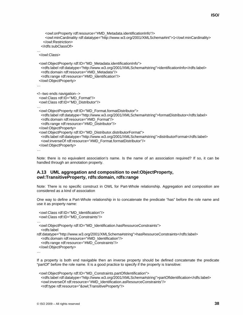
ISO/
© ISO 2009 – All rights reserved 38
<owl:onProperty rdf:resource="#MD_Metadata.identificationInfo"/> <owl:minCardinality rdf:datatype="http://www.w3.org/2001/XMLSchema#int">1</owl:minCardinality> </owl:Restriction> </rdfs:subClassOf> … </owl:Class> <owl:ObjectProperty rdf:ID="MD_Metadata.identificationInfo"> <rdfs:label rdf:datatype="http://www.w3.org/2001/XMLSchema#string">identificationInfo</rdfs:label> <rdfs:domain rdf:resource="#MD_Metadata"/> <rdfs:range rdf:resource="#MD_Identification"/> </owl:ObjectProperty> … <!--two ends navigation--> <owl:Class rdf:ID="MD_Format"/> <owl:Class rdf:ID="MD_Distributor"/> … <owl:ObjectProperty rdf:ID="MD_Format.formatDistributor"> <rdfs:label rdf:datatype="http://www.w3.org/2001/XMLSchema#string">formatDistributor</rdfs:label> <rdfs:domain rdf:resource="#MD_Format"/> <rdfs:range rdf:resource="#MD_Distributor"/> </owl:ObjectProperty> <owl:ObjectProperty rdf:ID="MD_Distributor.distributorFormat"> <rdfs:label rdf:datatype="http://www.w3.org/2001/XMLSchema#string">distributorFormat</rdfs:label> <owl:inverseOf rdf:resource="#MD_Format.formatDistributor"/> </owl:ObjectProperty> … Note: there is no equivalent association’s name. Is the name of an association required? If so, it can be handled through an annotation property.
A.13 UML aggregation and composition to owl:ObjectProperty, owl:TransitiveProperty, rdfs:domain, rdfs:range
Note: There is no specific construct in OWL for Part-Whole relationship. Aggregation and composition are considered as a kind of association
One way to define a Part-Whole relationship in to concatenate the predicate “has” before the role name and use it as property name:
<owl:Class rdf:ID="MD_Identification"/> <owl:Class rdf:ID="MD_Constraints"/> … <owl:ObjectProperty rdf:ID="MD_Identification.hasResourceConstraints"> <rdfs:label rdf:datatype="http://www.w3.org/2001/XMLSchema#string">hasResourceConstraints</rdfs:label> <rdfs:domain rdf:resource="#MD_Identification"/> <rdfs:range rdf:resource="#MD_Constraints"/> </owl:ObjectProperty> …
If a property is both end navigable then an inverse property should be defined concatenate the predicate “partOf” before the role name. It is a good practice to specify if the property is transitive:
<owl:ObjectProperty rdf:ID="MD_Constraints.partOfIdentification"> <rdfs:label rdf:datatype="http://www.w3.org/2001/XMLSchema#string">partOfIdentification</rdfs:label> <owl:inverseOf rdf:resource="#MD_Identification.asResourceConstraints"/> <rdf:type rdf:resource="&owl;TransitiveProperty"/>
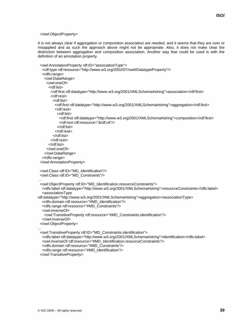
ISO/
© ISO 2009 – All rights reserved 39
</owl:ObjectProperty>
It is not always clear if aggregation or composition association are needed, and it seems that they are over or misapplied and as such the approach above might not be appropriate. Also, it does not make clear the distinction between aggregation and composition association. Another way that could be used is with the definition of an annotation property.
<owl:AnnotationProperty rdf:ID="associationType"> <rdf:type rdf:resource="http://www.w3.org/2002/07/owl#DatatypeProperty"/> <rdfs:range> <owl:DataRange> <owl:oneOf> <rdf:list> <rdf:first rdf:datatype="http://www.w3.org/2001/XMLSchema#string">association</rdf:first> <rdf:rest> <rdf:list> <rdf:first rdf:datatype="http://www.w3.org/2001/XMLSchema#string">aggregation</rdf:first> <rdf:rest> <rdf:list> <rdf:first rdf:datatype="http://www.w3.org/2001/XMLSchema#string">composition</rdf:first> <rdf:rest rdf:resource="&rdf;nil"/> </rdf:list> </rdf:rest> </rdf:list> </rdf:rest> </rdf:list> </owl:oneOf> </owl:DataRange> </rdfs:range> </owl:AnnotationProperty> <owl:Class rdf:ID="MD_Identification"/> <owl:Class rdf:ID="MD_Constraints"/> … <owl:ObjectProperty rdf:ID="MD_Identification.resourceConstraints"> <rdfs:label rdf:datatype="http://www.w3.org/2001/XMLSchema#string">resourceConstraints</rdfs:label> <associationType rdf:datatype="http://www.w3.org/2001/XMLSchema#string">aggregation</associationType> <rdfs:domain rdf:resource="#MD_Identification"/> <rdfs:range rdf:resource="#MD_Constraints"/> <owl:inverseOf> <owl:TransitiveProperty rdf:resource="#MD_Constraints.identification"/> </owl:inverseOf> </owl:ObjectProperty> … <owl:TransitiveProperty rdf:ID="MD_Constraints.identification"> <rdfs:label rdf:datatype="http://www.w3.org/2001/XMLSchema#string">identification</rdfs:label> <owl:inverseOf rdf:resource="#MD_Identification.resourceConstraints"/> <rdfs:domain rdf:resource="#MD_Constraints"/> <rdfs:range rdf:resource="#MD_Identification"/> </owl:TransitiveProperty>
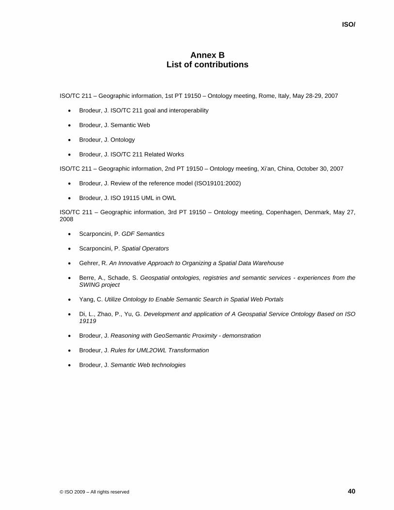
ISO/
© ISO 2009 – All rights reserved 40
Annex B List of contributions
ISO/TC 211 – Geographic information, 1st PT 19150 – Ontology meeting, Rome, Italy, May 28-29, 2007
• Brodeur, J. ISO/TC 211 goal and interoperability
• Brodeur, J. Semantic Web
• Brodeur, J. Ontology
• Brodeur, J. ISO/TC 211 Related Works
ISO/TC 211 – Geographic information, 2nd PT 19150 – Ontology meeting, Xi’an, China, October 30, 2007
• Brodeur, J. Review of the reference model (ISO19101:2002)
• Brodeur, J. ISO 19115 UML in OWL
ISO/TC 211 – Geographic information, 3rd PT 19150 – Ontology meeting, Copenhagen, Denmark, May 27, 2008
• Scarponcini, P. GDF Semantics
• Scarponcini, P. Spatial Operators
• Gehrer, R. An Innovative Approach to Organizing a Spatial Data Warehouse
• Berre, A., Schade, S. Geospatial ontologies, registries and semantic services - experiences from the SWING project
• Yang, C. Utilize Ontology to Enable Semantic Search in Spatial Web Portals
• Di, L., Zhao, P., Yu, G. Development and application of A Geospatial Service Ontology Based on ISO 19119
• Brodeur, J. Reasoning with GeoSemantic Proximity - demonstration
• Brodeur, J. Rules for UML2OWL Transformation
• Brodeur, J. Semantic Web technologies


