Earth Observation in support of the Western Indian Ocean...
24
Date : February 29th 2012 Earth Observation in support of the Western Indian Ocean Marine Highway Development and Coastal and Marine Contamination Prevention Project - Oil spill detection & Coral reef monitoring Juan GAVIRIA, Sector Leader AFTTR
Transcript of Earth Observation in support of the Western Indian Ocean...

Date : February 29th 2012
Earth Observation in support of theWestern Indian Ocean Marine Highway Development and Coastal and Marine Contamination Prevention Project -
Oil spill detection & Coral reef monitoring
Juan GAVIRIA, Sector Leader AFTTR

-The issue- What kinds of oil spills ?
- What kind of support is expected ?
-The service- How does it work ?
- Why use satellites ?
- User interface
-Results- Achieved coverage
- Detected spills
- Identified polluters
- Feedback from users
-Conclusion and perspectives
Content

Accidental spills Shipwreck, vessel collisions, spilling rig Infrequent events Large amounts of oil released Crisis situation lasting days or weeks
Deliberate spills (illegal discharge) Vessels washing their tanks Smaller amounts of oil (in general) But extremely frequent Pollution visible few hours
The issueWhat kinds of oil spills ?

The issueWhat kind of support is expected ?
Provide real-time monitoring support In case of accidental spills, quick activation of the system in order to support
antipollution operations: Monitor slick position and extent Forecast slick drift
In case of deliberate spills, systematic surveillance of sensitive areas in order to: Early detect slicks (if possible) Identify polluter Send on-site means for prosecution
Compile information In order to better assess and characterize the problem (where, when and
how often ?)

The serviceHow does it work ?
- Radar satellites image oil slicks on sea-surface- Sat-AIS collect AIS messages broadcasted by vessels
Oil Spill detection
Polluteridentification
MV OCEAN PEARL

The serviceWhy use satellites ?
- Radar satellites for oil spill detection- Radar technology: operational surveillance: independent of
day/night & cloud cover- Wide area monitoring (400 km swath): a single satellite pass may
image the entire Channel area in few seconds- Optimal when combined with aerial surveillance: satellite detection
used to optimize aircraft missions (sent directly on the polluted sites)
- Deterrent effect: “we’re watching you from space !”
- AIS satellites for polluter identification - Unambiguous identification of a vessel in the vicinity of a slick- Broad coverage, without deploying a network of AIS coastal
receivers

The serviceUser interface
- An operational and user-friendly interface to:- Select and order the acquisitions of interest- Check oil spill detection reports- Check polluter identification reports
- On-line access through a simple web browser
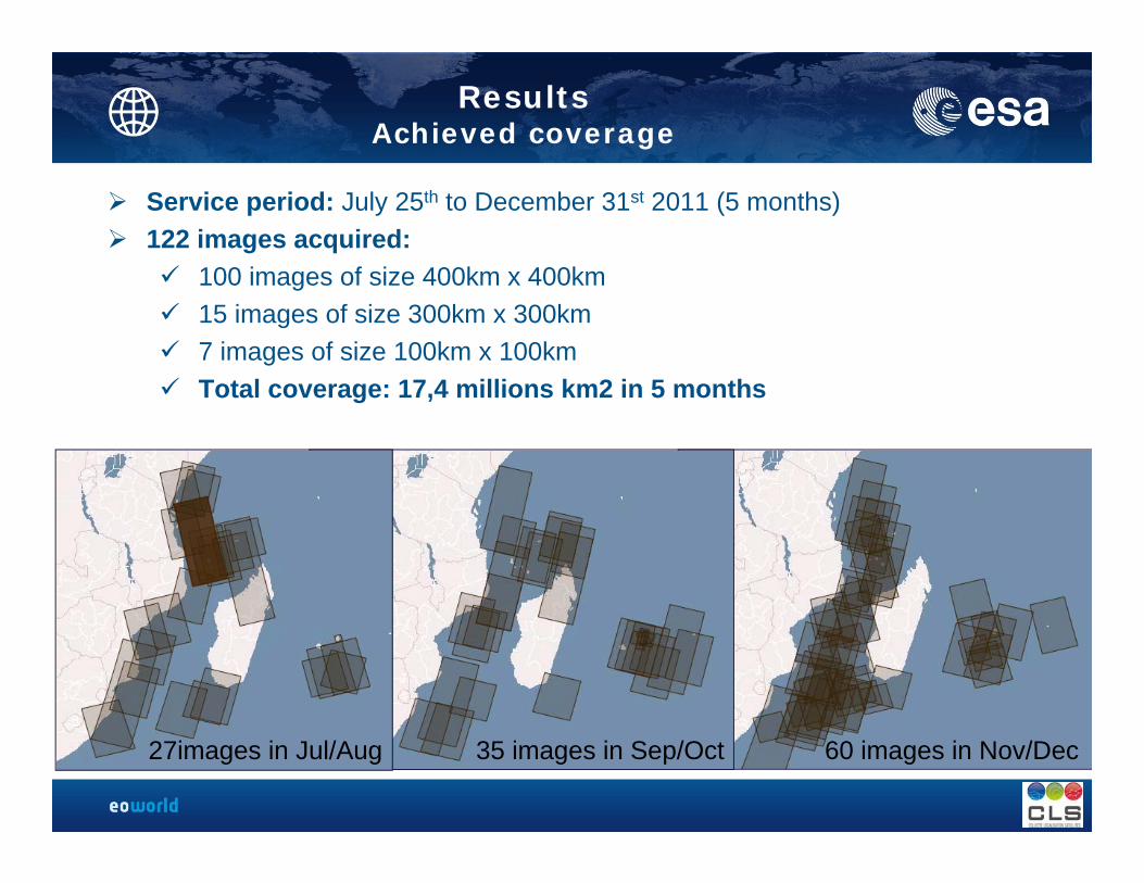
ResultsAchieved coverage
Service period: July 25th to December 31st 2011 (5 months) 122 images acquired:
100 images of size 400km x 400km 15 images of size 300km x 300km 7 images of size 100km x 100km Total coverage: 17,4 millions km2 in 5 months
27images in Jul/Aug 35 images in Sep/Oct 60 images in Nov/Dec

Project ResultsDetected spills
32 spills were detectedDetection rate: 28% per imageSpills Lengths: from 1 to 150 km

Project ResultsSpills locations in line with maritime routes

Project ResultsIdentification of polluters
6 potential polluters were identifiedIdentification rate: 19% per oil spill

Focus on one case: Pollution off Comoros, July 28th 2011 19:32 UTC
Ile d’Anjouan
Ile de Mayotte

Focus on one case: Pollution off Comoros, July 28th 2011
46 Nm
polluter
Comoros EEZ
French EEZ

Focus on one case: Pollution off Comoros, July 28th 2011
MSC Sarawak

ResultsFeedback from users
- Positive feedback mostly from France, Mauritius and South Africa- Patrol aircraft flew to check detected spills (Mauritius, France)- Suspected polluters were boarded for inspection while in port transit (RSA)
- Testimonies: - “a big THANK YOU for all the daily reports for the WIOMH Project region. It
was indeed very enlightening and gave us unique opportunities to ‘see’ what is happening in our waters far off our coastlines”
- “the message will travel about oil detection by satellite in our region”- “The word is out there that countries in the region are now able to identify
polluters so it is making an impact”

Conclusions and perspectives
- The project was successful in demonstrating that:- Oil spill can be detected (with a rate of 28% per image)- Polluter can be identified (with a rate of 19% per oil spill)
- Users feedback was very positive; for the first time, the issue of oil spill occurrence was assessed on a regional scale and turned out to be quite serious
- Thanks to the new antenna receiving station in La Réunion, better delivery time should be expected in the future (from 1h30 now to less than 30 minutes in the future)
- The service is ready to be included in the WIOMH project

Users
Concept of operationsService chain
CLS Order desk
Radar satellite
Ground station
CLS Operational center
Area of interest
Satellite operating agency
1Acquisition plan dialogue
2a Tasking
Acquisition
Downlink
4Oil pollution report
Sat-AISData provider
3Polluter identification report
2b
2c

-Step 1: Acquisition planning (T0 – 3 weeks)
- Users browse available scenes and send wish list to CLS
- T0 – 4 days (or less) in emergency mode
-Step 2: Image acquisition (T0)
- Satellite images the Area of Interest
-Step 3: Receive oil pollution report (T0 + 1 hour)
- Check on-line the report for any detected pollution
- T0+40 minutes if local antenna is used
-Step 4: Receive polluter identification report (T0 + 3 hours)
- Applicable only when a pollution is detected in Step 3
- Check on-line the report for any identified polluter
Concept of operationsSteps from users perspective

- On August 6th, the cargo Angel One ran aground the Mauritian reef of Poudre d’Or
- CLS was requested to monitor the wreckage in order to provide early warning in
case of oil pollution
- Seven high-resolution images were acquired with short time notice (few days)
- Fortunately, no oil spill occurred.
-
Example of Support to Crisis Monitoring of the Angel One wreckage

Example of Support to Crisis Monitoring of the Angel One wreckage
Angel One wreckage
Other ships
August 30th, 15:03 UTC

Example of Support to Crisis Monitoring of the Angel One wreckage
Angel One wreckage
Other ships
September 3rd, 14:45 UTC

Example of Support to Crisis Monitoring of the Angel One wreckage
Angel One wreckage
Other ships
September 4th, 05:37 UTC

Example of Support to Crisis Monitoring of the Angel One wreckage
Angel One wreckage
Other ships
September 8th, 01:36 UTC
Thank you for your attention !