City of Prineville TRANSPORTATION SYSTEM PLAN Documents... · were used to refine the TSP goals and...
91
City of Prineville TRANSPORTATION SYSTEM PLAN November 2013
Transcript of City of Prineville TRANSPORTATION SYSTEM PLAN Documents... · were used to refine the TSP goals and...

City of Prineville
TRANSPORTATION SYSTEM PLANNovember 2013

Prineville Transportation System Plan
Prineville, Oregon
Prepared By: Kittelson & Associates, Inc. 354 SW Upper Terrace Drive Suite 101 Bend, Oregon 97702 (541) 312-8300
Project Manager: Joe Bessman, P.E., PTOE Project Principal: Julia Kuhn, P.E.
Project No. 12221
November 2013
This project is partially funded by a grant from the Transportation and Growth Management (TGM) Program, a joint program of the Oregon Department of Transportation and the Oregon Department of Land Conservation and Development. This TGM grant is financed, in part, by federal Safe, Accountable, Flexible, and Efficient Transportation Equity Act: A Legacy for Users (SAFETEA-LU), local government, and the State of Oregon funds. The contents of this document do not necessarily reflect views or policies of the State of Oregon.

Prineville Transportation System Plan November 2013
iii
TABLE OF CONTENTS Introduction ....................................................................................................................................... 8
TSP Process .................................................................................................................................................................................. 8
Public Engagement ...................................................................................................................................................................... 8
Regulatory Context ...................................................................................................................................................................... 9
TSP Organization ....................................................................................................................................................................... 10 Transportation System Plan ................................................................................................................. 13
State and Regional Planning Context ........................................................................................................................................ 13
Policy/Regulatory Elements....................................................................................................................................................... 15
Transportation System Needs ................................................................................................................................................... 29
Transportation System Improvement Strategies ...................................................................................................................... 30
Transportation System Improvement Projects ......................................................................................................................... 34
Rail, Air, Pipeline, & Surface Water Plans .................................................................................................................................. 56 Transportation Planning Toolbox......................................................................................................... 59
Increasing “Active” Transportation ........................................................................................................................................... 59
Connectivity ............................................................................................................................................................................... 68
Intersection Control .................................................................................................................................................................. 68
Neighborhood traffic management ........................................................................................................................................... 70 Transportation Funding and Implementation Plan ............................................................................. 75
Estimated Revenue .................................................................................................................................................................... 76
Cost of 20-year Needs ............................................................................................................................................................... 76
Local Funding Mechanisms........................................................................................................................................................ 77
State and Federal Grants ........................................................................................................................................................... 79 Implementation Ordinances ................................................................................................................ 82
Encourage a mix of uses in residential and employment areas ................................................................................................ 82
Street Design Options ................................................................................................................................................................ 83
Plan for Alternate Modes and Connectivity .............................................................................................................................. 83
Transportation Demand Management ...................................................................................................................................... 84
Permitting and Coordination ..................................................................................................................................................... 84
Traffic Impact Analysis Requirements ....................................................................................................................................... 85
Prineville Transportation System Plan November 2013
iv
LIST OF FIGURES Figure 1 City of Prineville TSP Study Area ................................................................................. 11
Figure 2 Functional Classification ............................................................................................. 19
Figure 3 City of Prineville Truck Routes .................................................................................... 21
Figure 4 Illustration of Access Improvements .......................................................................... 24
Figure 5 System Needs .............................................................................................................. 31
Figure 6 Roadway Improvement Projects ................................................................................. 36
Figure 7 Intersection Improvement Projects ............................................................................ 41
Figure 8 Pedestrian Improvement Projects .............................................................................. 44
Figure 9 Bicycle Improvement Projects .................................................................................... 47
Figure 10 Multi-Use Path Visionary Improvement Projects ....................................................... 50
Figure 11 Downtown Couplet: 3rd Street and SE 2nd Street Street Alignment Concepts............ 53
Figure 12 Downtown Couplet: 3rd Street and NW 4th Street Alignment Concepts .................... 54

Prineville Transportation System Plan November 2013
v
LIST OF TABLES Table 1 Transportation System Plan Public Involvement Summary .......................................... 9
Table 2 State Highway Classification ....................................................................................... 14
Table 3 Intersection Volume-to-Capacity Ratio Performance Standards/Targets .................. 17
Table 4 Access Management Spacing Standards for Highway Segments ............................... 23
Table 5 Access Improvement Process ..................................................................................... 25
Table 6 Roadway Cross-Section Standards .............................................................................. 26
Table 7 Short-Term Roadway Improvement Projects ............................................................. 35
Table 8 Medium-Term Roadway Improvement Projects ........................................................ 37
Table 9 Long-Term Roadway Improvement Projects .............................................................. 38
Table 10 Vision-Term Roadway Improvement Projects ............................................................ 38
Table 11 Intersection Improvement Projects ............................................................................ 40
Table 12 Pedestrian Improvement Projects .............................................................................. 42
Table 13 Pedestrian Crossing Projects ....................................................................................... 43
Table 14 Bicycle Improvement Projects .................................................................................... 45
Table 15 Maintenance Bicycle Improvements ......................................................................... 46
Table 16 Multi-use Trail Visionary Improvement Projects ........................................................ 49
Table 17 Safety Projects ............................................................................................................ 51
Table 18 Transportation Revenue ............................................................................................. 76
Table 19 Estimated Project Costs .............................................................................................. 76
Table 20 Estimated Project Costs .............................................................................................. 77
Table 21 Potential Local Funding Mechanisms ......................................................................... 78
Table 22 Potential State and Federal Grants ............................................................................. 80

Prineville Transportation System Plan November 2013
vi
APPENDICES
Volume 1
Appendix 1: City of Prineville Transportation Impact Analysis Requirements
Volume 2
The technical memorandums describe the methodology and analysis associated with the TSP and include technical appendices documenting the analysis parameters and results.
Section A Technical Memorandum 1: Plan and Policy Review
Section B Technical Memorandum 2: Goals and Objectives
Section C Technical Memorandum 3: Existing Conditions Inventory
Section D Technical Memorandum 4: Existing Conditions Analysis
Section E Technical Memorandum 5: Future No-Build Conditions
Section F Technical Memorandum 6: Alternatives Analysis
Section G Technical Memorandum 7: Preferred Alternative
Section H Technical/Project Advisory Committee Meeting Minutes

Section 1 Introduction

City of Prineville Transportation System Plan November 2013 Section 1: Introduction
Page 8
INTRODUCTION In collaboration with the Oregon Department of Transportation (ODOT) and Crook County, the City of Prineville initiated an update to its Transportation System Plan (TSP) in 2012. This TSP is intended to provide the City, County and ODOT with guidance for operating and improving the multimodal transportation system within the Prineville Urban Growth Boundary. The TSP focuses on priority projects, policies and programs for the next twenty years, but also provides a vision for longer-term projects that could be implemented should funding become available. The TSP is intended to be flexible to respond to changing community needs, economic opportunities, grants, and other revenue sources.
TSP PROCESS The TSP was updated based on:
Review of state, regional, and local transportation plans and policies it must either comply with or be consistent with.
Community input gathered through public workshops at key points in the project.
Technical and citizen advisory committee input on goals and objectives, transportation alternatives, and future project prioritization.
Using a detailed inventory of existing transportation facilities to serve as a foundation to identify near- and long-term transportation needs.
Evaluation of future transportation needs to support the land use vision and economic vitality of the urban area.
Prioritized improvements and strategies reflective of the community’s vision and fiscal realities.
PUBLIC ENGAGEMENT The update of the TSP provided City residents the opportunity to share their vision for the future of a multimodal transportation system to serve local, regional and statewide travel needs. Several citizens provided feedback through on-line commenting forums, meetings, and workshops. These comments were used to refine the TSP goals and policies, and define priority projects.

City of Prineville Transportation System Plan November 2013 Section 1: Introduction
Page 9
In addition to general forums, a Technical Advisory Committee (TAC) and a Public Advisory Committee (PAC) helped to guide all aspects of the TSP development. The TAC included staff from the City of Prineville, Oregon Department of Transportation, and Crook County. The PAC included community leaders from the City’s Planning Commission, local business owners, and representatives of local law enforcement, emergency response agencies, and other stakeholders. While they were separate committees, all meetings were conducted jointly so that all those involved were able to provide input and perspective throughout the TSP process.
A summary of the public engagement is provided in Table 1. All meetings were held in the City of Prineville City Council Chambers.
Table 1 Transportation System Plan Public Involvement Summary
Meeting Event Date Meeting Purpose/Objectives
Project Website Initiated June 1, 2012
Provide commenting options for the public, a central location to house draft and final documents, a calendar of project events, and announce new deliverables or project materials to subscribed users.
TAC/PAC Meeting #1 June 13, 2012 Discuss goals of TSP update; present summary of plan and policy review
TAC/PAC Meeting #2 November 29, 2012 Present existing conditions analysis and future no-build needs
Public Workshop #1 November 29, 2012 Present goals, plans and policy, and existing conditions
TAC/PAC Meeting #3 February 19, 2013 Review future transportation needs and summarize alternative options for evaluation
TAC/PAC Meeting #4 May 7, 2013 Review alternatives and funding options; gather feedback on preferred alternatives
TAC/PAC Meeting #5 June 12, 2013 Present preferred alternative and funding options
TAC/PAC Meeting #6 July 18, 2013 Present draft TSP and implementing ordinances
Public Workshop #2 July 18, 2013 Gather public input on the preferred plan City Planning Commission Hearing
Scheduled for August 20, 2013 Review draft TSP.
Joint City Council and County Court Hearing
Scheduled for September 10, 2013 Review draft TSP.
REGULATORY CONTEXT The Transportation System Plan update was guided by Oregon Revised Statute (ORS) 197.712 and the Department of Land Conservation and Development (DLCD) administrative rule known as the

City of Prineville Transportation System Plan November 2013 Section 1: Introduction
Page 10
Transportation Planning Rule (TPR). Through this rule, the State of Oregon requires that the TSP be based on the Comprehensive Plan land uses and that it provide for a transportation system that accommodates the expected growth in population and employment over the next 20 years. The TPR also requires the following elements:
A road plan for the arterial and collector system, including functional classifications of streets, and standards for the layout of local streets that provide reasonably direct routes for bicycle and pedestrian travel
A public transportation plan
A bicycle and pedestrian plan
An air, rail, water and pipeline transportation plan
Policies and land use strategies for implementing the plan
A transportation financing plan
In each of these elements, the TPR requires that the plan considers and incorporates the needs of all users and all travel modes. In addition, the TPR requires that local jurisdictions adopt land use and subdivision ordinance amendments to protect transportation facilities and to provide bicycle and pedestrian facilities between residential, commercial, and employment/institutional areas. Local communities must coordinate their respective plans with the applicable county, regional, and state transportation plans.
The Prineville TSP addresses the state requirements for all affected facilities within its Urban Growth Boundary (UGB). The existing UGB is shown in Figure 1.
TSP ORGANIZATION This TSP is organized in two volumes.
Volume 1: Transportation System Plan
Volume 1 includes content on the key areas of interest within the Transportation System Plan.
Volume 2: Technical Appendices
Volume 2 contains the technical information and memorandums used to develop the policies and recommendations in the TSP.

SM
AINST
NE PETERS RD
SE C
OM
BS
FLA
T R
D
SEJUNIPER
CANYO
NRD
SE LYNN BLVDN
MA
IN S
T
NE
YELLO
WP
INE
RD
NW 3RD ST NE 3RD ST
NE
BA
RN
ES
RD
NW3RD ST
NWLAMONTA RD
SED
AVIS
LOO
P
NE BARNES BUTTE RD
SWTO
MM
CC
ALL
RD
SW HOUSTON LAKE RD
SW G
EOR
GE
MIL
LIC
AN
RD
NE OCHOCO HWY
NW MADRAS HW
Y
SW 126 HWY
SE PAULINA HWY
NWO'NEIL HWY
SC
RO
OK
EDR
IVE
RH
WY
UV126
UV380
UV370
UV27
£¤26
£¤26
SW AIRPORT RD
NE WAINWRIGHT RD
NE WITTMER RD
SW D
EE
R S
TSE 5TH ST
NWG
ARD
NE
RR
D
SW PARK DR
NE
ELM
ST
NE SUNRISE ST
NE RAWHIDE LN
NE LOPER AVE
NW 9TH ST
SE LINCOLN RD
NW APOLLO RD
NE
SU
GA
RP
I NE
RD
SE MELROSE DR
NW 2ND ST
NW PINECRESTD
R
NE OCHOCO AVE
NW MCDONALD RD
SE
FA
IRV
IEW
ST
NW 4TH ST
NW 6TH ST
NE
HUDSPETH RD
NE OWENS RD
NW 5TH ST
NE 7TH ST
SE 7TH ST
NE 6TH ST
SE J
ER
RY
DR
SE 4TH ST
SE
GA
RN
ER
ST
NE 2ND ST
SE 2ND ST
SE
HO
LLY
ST
NE 4TH ST
NW
DE
ER
ST
E 1ST ST
SE 3RD ST
NE
JU
NIP
ER
ST
SW
RIM
RO
CK
RD
NW PEPPERMINT LN
SW CRESTVIEW RD
SE HILL ST
SW EMPIRE DR
NW GUMPERT RD
SEBU
LLBLV
D
NW WEST HILLS RD
NE
SU
NS
ET
VIE
W L
N
NW
CE
NTU
RY
DR
NE LAUGHLIN RD
SWHIG
HDESERT DR
NW
LON
SM
ITHR
D
NW ROSEWOOD DR
NE SUNRISE LN
NW RIMROCK ACRESLO
OP
SE CAREY FOSTER RD
SW WILEY RD
SW LANDFILL RD
SW
WE
STW
OO
D D
R
SWCO
NN
ECT
WAY
SW
BA
LDW
IN R
D
SW HUNTER RD
SE RIVERVIE WR
D
NEWAYFINDER DR
SE
KE
NN
ED
Y W
AY
Sources: Esri, USGS, NOAA
Prineville TSP February 2013
¯
Figure
1
City Boundary
Study Area/Urban GrowthBoundary (UGB)
H:\p
rojfi
le\1
2221
- P
rinev
ille
TSP
\gis
\pdx
gis\
Dra
ft TS
P\8
-1 S
tudy
Are
a.m
xd -
agrif
fin -
10:
09 A
M 7
/16/
2013
Coordinate System: NAD 1983 HARN StatePlane Oregon South FIPS 3602 Feet Intl Data Source: Crook County, City of Prineville
Study AreaCity of Prineville, Oregon
UV126
UV380
£¤26£¤26
UV27
CROOK COUNTY
##
0 0.45 0.9 Miles

Section 2 Transportation System Plan

City of Prineville Transportation System Plan November 2013 Section 2: Transportation System Plan
Page 13
TRANSPORTATION SYSTEM PLAN The City of Prineville’s current TSP was adopted in 2005. Since then, several master planned developments have been entitled and initiated within the City, reshaping the scale and areas of growth. In addition, the City and State have invested in the City’s rail infrastructure to support industrial sector growth, the OR 126 Corridor Facility Plan was completed and identifies needs that impact the downtown area, and the City implemented a transportation system development charge (SDC). The updated Transportation System Plan (TSP) provides a long-term vision and policy framework that accounts for the changes that have occurred over the past eight years, and provides guiding principles to shape future enhancements to the transportation system that can support expected growth and economic development.
STATE AND REGIONAL PLANNING CONTEXT The Prineville Transportation System Plan (TSP) identifies the transportation-related projects, programs and policies needed over the next 20 years to serve local, regional and statewide multi-modal travel within the Urban Growth Boundary (UGB). The TSP considers the transportation plans for county and ODOT facilities and is consistent with the requirements of statewide and regional transportation plans and policies.
State and Regional Facilities
Prineville is situated at the junction of several highways. These highways converge on the west side of Prineville and are combined through the downtown core along N 3rd Street. The City is dependent on these regional connections for much of its inbound and outbound employment, recreation, and shopping needs. The OR 126 highway alignment includes winding, steep grade through rimrock that surrounds the City. The Crooked River constrains the ability to make major improvements to the State system or to provide alternative routes.
The classification of the state highways that travel through Prineville are summarized in Table 2. OR 126 and US 26 are the City’s primary linkage to surrounding Central Oregon cities; they converge at the Prineville “Y” and then serve as the major east-west route through downtown Prineville. OR 27 (Main Street) and OR 380 (SE Combs Flat Road/SE Paulina Highway) are also ODOT facilities that connect Prineville to other areas of Crook County.
Within the downtown, 3rd Street is classified by ODOT as a Special Transportation Area with an emphasis on local business access and multimodal travel. Commercial uses front the corridor between

City of Prineville Transportation System Plan November 2013 Section 2: Transportation System Plan
Page 14
the US 26/OR 126 junction (the “Y”) and Combs Flat Road, and are reliant on the highway for primary access.
Table 2 State Highway Classification
Route Name
(Hwy #) Description
Highway
Classification NHS
Freight/
Truck
Route
Special
Designations
US 26
Ochoco Hwy (41) East of Prineville “Y” Statewide Yes No STA1
Madras Hwy (360) West of Prineville “Y” Regional No Yes None
OR 27, Crooked River Hwy (14) Outside City Limits District No No None
OR 126, Ochoco Hwy (41) Entire Segment Statewide Yes Yes Expressway2
OR 370, O’Neil Hwy (370) Entire Segment District No No None
OR 380, Paulina Hwy (380) Entire Segment District No No NoneNHS = National Highway System 1 STA= Special Transportation Area – from Milepost 18.24 (Locust Avenue) to 19.38 (Spruce Lane) 2 EXP= Expressway - from Milepost 1.37 to 17.92
Guiding Plans and Policies
State policy and design guidance, regional/County plans, localized plans, and modal plans inform the future multimodal needs of Prineville. Elements of these plans are incorporated throughout this document; key findings from these plans and their incorporation into the Transportation System Plan are outlined below.
The OR 126 Corridor Plan identified options for the Tom McCall, O’Neil Highway, and “Y” Junction that required further evaluation as part of this TSP due to their impacts on the City’s downtown. The traffic growth estimates for the corridor plan were developed prior to completion of a travel demand model, and these assumptions were revisited within the TSP and significantly reduced. This substantially decreased the sizing of the needed improvements. This TSP both incorporates and amends the corridor plan.
Since the OR 126 Corridor Plan was completed, the ODOT roundabout policy has been amended. This amendment allows roundabouts on the State highway system if proper coordination with affected stakeholders demonstrates that all users can be appropriately accommodated.
Data center development near the airport has provided a new outlook on Prineville’s economic growth potential. Although the data centers impact the transportation system during construction, the long-term impacts and travel demands are expected to be low. Access to the industrial lands near the airport is a critical element of supporting continued growth of the data centers.
State highway mobility targets and access standards have changed since the prior TSP was adopted; the new State policies will enable more flexibility for the long-term growth of the city and needed transportation infrastructure.
City of Prineville Transportation System Plan November 2013 Section 2: Transportation System Plan
Page 15
A number of large properties within the city have been master planned during the past ten years. The growth patterns and associated infrastructure for these properties was not fully accounted for in the previous TSP. In particular, the Ochoco lumber site and IronHorse will be key redevelopment sites within Prineville given their size and location. The TSP update accounts for planned growth in these areas and other employment lands.
Completion of the 2nd Street extension and connection to OR 126 has provided the City with an alternate route to 3rd Street – US 26/OR 126; the benefits of this parallel corridor and associated changes in travel patterns illustrate the potential of enhancing the City’s roadway network.
Existing transit infrastructure in Prineville is very limited, with Cascades East Transit service to the City provided at a park-and-ride located along the shoulder near the “Y.” The ODOT Region 4 Park and Ride Lot Plan has identified an alternative location as the preferred location for a new park-and-ride lot. The 2013 COIC Regional Transit Master Plan indicates that Prineville could reach the threshold for fixed route service later in the life of the RTMP and explores local service concepts. The Master Plan also recommends improvements to the Community Connector shuttles.
The City of Prineville is actively improving pedestrian facilities around schools and its Ochoco Creek trail system. These actions follow development of Safe Routes to Schools Plans. Additional sidewalks and trails will provide linkages throughout the City.
The City is pursuing design plans to modify Main Street between Peters Road and N 3rd Street. These efforts are occurring in parallel with the TSP efforts. Critical elements of this project will be pedestrian and bicycle improvements throughout the entire corridor, and enhancements to the alignment of the existing traffic signal at 10th Street. The prior TSP’s recommendation to extend 9th Street due east through the Price Slasher was reevaluated to account for changes to the rail system and other changes in development patterns.
Additional details on the literature review can be found within Volume 2, Section A of this Transportation System Plan.
POLICY/REGULATORY ELEMENTS A number of transportation-related policy and regulatory elements will guide development review and project development in Prineville in the future. These elements are discussed in more detail below and include:
TSP Goals
City of Prineville Traffic Impact Analysis (TIA) – Development Requirements Policy
Intersection Performance Standards
Roadway Functional Classification
Truck Routes
Access Spacing Guidelines
Street Design Standards

City of Prineville Transportation System Plan November 2013 Section 2: Transportation System Plan
Page 16
TSP Goals
The following goals reflect the vision for the long-term transportation system for the City based on guidance from previous plans and insights offered by community leaders, residents, business owners, freight representatives, and other affected stakeholders.
Ensure a safe, accessible, and efficient transportation system for all users. Integrate bicycle and pedestrian pathways, sidewalks, and bicycle lanes through the community, particularly to connect residential areas with schools and activity centers. Improve the local circulation system to reduce the community’s reliance on State Highways to travel to local destinations. Build and maintain the transportation system to facilitate economic development in the region. Improve system performance by balancing mobility and access, particularly along main travel routes. Minimize the impacts of transportation system development on the natural and built environment.
The transportation needs and alternatives identified to address them reflect the development of a safe, multimodal system that reduces reliability on the State highways and promotes economic development. The recommended plan includes projects prioritized based on alternatives evaluation that reflects these goals.
City of Prineville Traffic Impact Analysis (TIA) – Development Requirements Policy
The City adopted Transportation Impact Analysis (TIA) requirements within its 2005 Transportation System Plan, which was subsequently amended by Ordinance No. 1167 in December 2009. These revised standards were based on those adopted by the City of Bend. Recommended modifications provided in Appendix 1 reflect the less congested conditions present within the City of Prineville. These standards apply to facilities under City of Prineville jurisdiction; roadways with County or ODOT jurisdiction would be subject to the more stringent standards where a discrepancy exists.
Intersection Performance Standards
Cities and agencies establish minimum performance standards for the transportation system to help guide planning efforts, project development, and land use entitlements. These standards are often a reflection of the amount of delay or congestion experienced by a motorist at intersections. This performance measure is used to define whether or not a location is performing adequately or will require improvements.
In Prineville, intersections are under the roadway jurisdiction of the City, Crook County, or the Oregon Department of Transportation (ODOT). Each agency has its own performance standards or targets. Where multiple agencies have jurisdiction, the most stringent performance measure governs. The roadways that fall within ODOT’s jurisdiction include the five state highways summarized in Table 2. The highway classifications identify the mobility targets and access management standards for each facility.

City of Prineville Transportation System Plan November 2013 Section 2: Transportation System Plan
Page 17
Intersection performance targets for ODOT Facilities are volume-to-capacity ratio targets for peak fifteen-minute operating conditions during the 30th highest annual hour. Table 6 of the Oregon Highway Plan (OHP - Reference 4) provides the peak hour volume-to-capacity ratio targets for all signalized and unsignalized intersections outside the Portland Metro area. Table 3 shows the applicable governing jurisdiction, intersection control, and performance standard for each study intersection.
Table 3 Intersection Volume-to-Capacity Ratio Performance Standards/Targets
Intersection Jurisdiction Traffic Control Maximum Volume-
to-Capacity Ratio
1. N Main St & NE 10th St City of Prineville Signalized 1.0
2. N Main St & NE 9th St City of Prineville Stop-Controlled 1.0
3. N Main St & NE 4th St City of Prineville Stop-Controlled 1.0
4. US 26 & NW 9th St ODOT Stop-Controlled 0.90
5. NW Hardwood Ave & 3rd St/US 26 ODOT Signalized 0.95
6. NW Deer St & 3rd St/US 26 ODOT Signalized 0.95
7. N Main St & 3rd St/US 26 ODOT Signalized 0.95
8. N Elm St & 3rd St/US 26 ODOT Signalized 0.95
9. NE Combs Flat Rd & 3rd St/US 26 ODOT Signalized 0.90
10. NE Laughlin Rd & 3rd St/US26 ODOT Stop-Controlled 0.95
11. NW Meadows Lakes Dr & N 2nd St City of Prineville Stop-Controlled 1.0
12. NW Deer St & N 2nd St City of Prineville Stop-Controlled 1.0
13. SE Main St & N 2nd St City of Prineville Stop-Controlled 1.0
14. SE Main St & SE Lynn Blvd City of Prineville Stop-Controlled 1.0
15. SE Combs Flat Rd & SE Lynn Blvd ODOT Stop-Controlled 0.95
16. WB OR 126 & WB US 26 ODOT Yield-Controlled 0.90
17. EB OR 126 & EB US 26 ODOT Yield-Controlled 0.90
18. WB OR 126 & EB US 26 ODOT Stop-Controlled 0.90
19. O'Neil Hwy & OR 126 ODOT Stop-Controlled 0.90
20. S Rimrock Rd & OR 126 ODOT Stop-Controlled 0.90
21. Tom McCall Rd & OR 126 ODOT Stop-Controlled 0.90
22. SW Millican Rd & OR 126 ODOT Stop-Controlled 0.90
Intersection performance standards for City of Prineville roadways are defined separately by intersection control type. Generally, the City requires that its intersections operate at Level-of-Service “E” or better, and that intersection operate within their carrying capacity. The City’s TIA Development Requirements Policy defines operations standards (see Appendix 1).

City of Prineville Transportation System Plan November 2013 Section 2: Transportation System Plan
Page 18
Roadway Functional Classification
Roadways are classified using arterial, collector, and local designations, depending on the intended function and the adjacent land use needs.
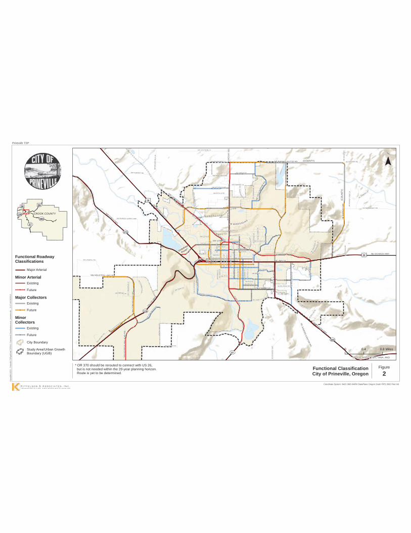
Major Arterials primarily provide mobility particularly between large population centers or activity generators. Mobility is emphasized over local access connections. Within Prineville, all major arterials are ODOT facilities. US 26 and OR 126 are examples of major arterial facilities. Their main function is to provide a connection east-west through town as well as to connect Prineville with nearby communities.
Minor Arterials are also intended to serve mobility needs over access needs in town. However, minor arterials provide important connections through town rather than connecting Prineville to other communities. Main Street is an example of a minor arterial in Prineville. Its main purpose is to connect the north and south areas of Prineville.
Major Collectors provide connection between local streets and the arterial street system. Trip lengths are generally shorter than on arterials. Collectors provide a link between local traffic generators and more regional facilities. An example of a Major Collector in Prineville is NE 2nd Street. NE 2nd Street’s primary function is to connect residential areas with Main Street and OR 126, regional facilities.
Minor Collectors are similar to Major Collectors in their purpose of linking local and regional traffic facilities. However, minor collectors typically provide access to and circulation within neighborhoods and industrial and commercial areas. SE 5th Street is an example of a minor collector. It connects all residences in the area to local schools and other residential areas.
Local Streets provide for direct access to land. Shorter trips are common and through trips are discouraged. Travel is generally at lower speeds than on other functional classification roads. Prineville has a number of local streets. These facilities generally connect to collectors.
Exhibit 1 illustrates the relationship between through traffic mobility and access as it relates to roadway functional classification. Figure 2 shows the functional classification of each roadway in Prineville. Roadways that are not labeled as a collector or arterial streets are designated as local streets.
Exhibit 1 Functional classification related to access and mobility. Source: A policy on Geometric Design of Highways and Streets, 2004.
S MAIN ST
SE
CO
MB
S F
LAT
RD
SE LYNN BLVD
N M
AIN
ST
NE MARIPOSA AVE
NW 3RD ST
NW
HA
RW
OO
D S
T
NE 3RD ST
NW 10TH ST
N M
CK
AY R
D
NE
BA
RN
ES
RD
NW3RD ST
NWLAMONTA RD
NE
YEL
LOW
PINE
RD
NE BARNES BUTTE RD
SW
TOM
MC
CA
L LR
D
SE
JUN
IPERC
ANYO
NR
D
SW HOUSTON LAKE RD
SW
GE
OR
GE
MIL
LIC
AN
RD
NE OCHOCO HWY
NW MADRAS HW
Y
SE PAULINA HWY
NWO'NEIL HWY
SW 1
26 H
WY
27
380
370
126
26
26
SW A
IRPORT
RD
SE 3RD ST
NE 13TH ST
NE WITTMER RD
SW
DE
ER
ST
SE 6TH ST
NE
ELK
ST
NW
GA
RD
NE
R R
D
SW PARK DR
NE
ELM
ST
NE RAWHIDE LN
NE
OR
EG
ON
AVE
NE
TE
NN
ES
SEELN
NE
WIL
SH
IRE
DR
NE
MC
RA
E C
T
NE LOPER AVE
NW 9TH ST
SE LINCOLN RD
SW AVIATION BLV
D
NW APOLLO RD
NW 12TH ST
SE
WIL
LOW
DA
LE D
R
NE
SU
GA
RP
INE
RD
SE MELROSE DR
NW 2ND ST
SW
CLI
FFS
IDE
LN
NE OCHOCO AVE
SE
STE
AR
NS
RD
NW MCDONALD RD
NE
CO
UR
T S
T
NW 4TH ST
NW 6TH ST
NW
RO
LLO
RD
NE OWENS RD
NW 5TH ST
NE 7TH ST
SE 7TH ST
NE 6TH ST
SW 4TH ST
SE
DU
NH
AM
ST
NW 8TH STS
E G
AR
NE
R S
T
NW
EW
EN
ST
SE
KN
IGH
T S
T
NE 2ND ST
NW 7TH ST
SE 2ND ST
SE
ELM
ST
SE
HO
LLY
ST
NE
BE
LKN
AP
ST
NE 4TH ST
NW
DE
ER
ST
NW
CLA
YP
OO
LS
T
E 1ST ST
SE
CO
UR
T S
T
NW
BE
AVE
R S
T
NE
JU
NIP
ER
ST
NE
SA
GE
WA
Y
SW
RIM
RO
CK
RD
NW PEPPERMINT LN
SW CRESTVIEW RD
SE HILL ST
SW EMPIRE DR
NW GUMPERT RD
NW
BR
OO
KF
IELD
LN
SEBU
LLBL
VD
NW WEST HILLS RD
NE
SU
NS
ET
VIE
W L
N
SW
EW
EN
ST
NE WAINWRIGHT RD
NW
CE
NTU
RY
DR
NE LAUGHLIN RD
SWHIG
HDESERT DR
NW
LON
SMITH
RD
NE SUNRISE LN
NW LIDSTROM LN
NW RIMROCK ACRES LOOP
NE
CO
LES
RD
NWPEA
CO
CK
WA
LK
SE CAREY FOSTER RD
SW LANDFILL RD
NETR
AVE
RS
EL N
SW
CO
MM
ER
CE
CT
NW BUS EVANSLN
SE
KE
NN
ED
Y W
AYSW
CON
NE
CT
WAY
SW
BA
LDW
IN R
D
SW HUNTER RD
NE
WAY
FIN
DE
RD
R
Undefined
Route*
Sources: USGS, ESRI, TANA, AND
Figure
2
Functional RoadwayClassifications
Major Arterial
Minor ArterialExisting
Future
Major CollectorsExisting
Future
MinorCollectors
Existing
Future
City Boundary
Study Area/Urban GrowthBoundary (UGB)
H:\p
rojfi
le\1
2221
- P
rinev
ille
TSP
\gis
\Dra
ft TS
P\8
-2- F
unct
iona
l Cla
ssifi
catio
n.m
xd -
jsom
mer
ville
- 1
1:07
AM
9/5
/201
3
Coordinate System: NAD 1983 HARN StatePlane Oregon South FIPS 3602 Feet Intl
Functional ClassificationCity of Prineville, Oregon
126380
2626
27
CROOK COUNTY
0 0.4 0.8 Miles
Prineville TSP
* OR 370 should be rerouted to connect with US 26, but is not needed within the 20-year planning horizon. Route is yet to be determined.
(COUNTY)
(CO
UN
TY)

City of Prineville Transportation System Plan November 2013 Section 2: Transportation System Plan
Page 20
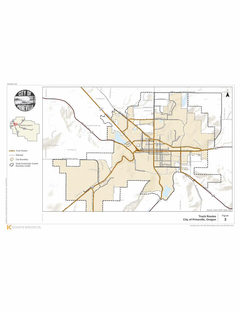
Truck Routes
To serve industrial properties and support future economic development efforts, the City of Prineville has designated several roadways as Truck Routes. The designation of these facilities as Truck Routes (See Figure 3) does not prohibit local delivery trucks from using other roadways, but is intended to encourage the use of these routes for regional freight needs through design and signage.
US 26 and OR 126 are designated as freight routes west of the Prineville “Y”, but where the highways join the freight route designation is removed. Despite removal of this designation, truck volumes are a considerable component of the highway traffic in Prineville, comprising between 11 percent and 30 percent of the overall traffic volumes, with half of these trucks single-unit delivery vehicles.
Based on the volume of freight traffic, design features of the highways should account for the dimensional and maneuvering needs of truck traffic regardless of whether the highways are designated freight or truck routes within the City. It is recommended that signage of a City of Prineville Truck Route designation is provided along all of the highways to highlight the importance of freight movements along these roads.
In addition to the State system, the following local streets should also be designated as City freight routes based on the land uses served and connections provided:
Main Street between Peters Road and the southern City boundary. Lamonta Road from the west UGB to Main Street. 9th Street from US 26 to Deer Street, Deer Street from 9th Street to Lamonta Road. Future extension east of Main Street from 10th Street to 7th Street-Laughlin Road. Peters Road extension between US 26 and Main Street.
S MAIN ST
NE PETERS RD
SE C
OM
BS
FLA
T R
D
SE LYNN BLVD
N M
AIN
ST
NE MARIPOSA AVE
NW 3RD ST
NW
HAR
WO
OD
ST
NE 3RD ST
NW 10TH ST
NE
BAR
NES
RD
NWLAMONTA RD
NE
YELL
OW
PIN
E R
D
NE BARNES BUTTE RD
SW
TOM
MC
CA L
LR
D
SW HOUSTON LAKE RD
SEJU
NIPER
CANYO
NRD
SW G
EOR
GE
MIL
LIC
AN R
D
NWO'NEIL HWY
NW MADRAS HW
Y
SEPAULINA HWY
SW 126 HWY
380
370
126
27
26
26
SW AIRPORT RD
NE WITTMER RD
SW D
EE
R S
T
SE 5TH ST
NE
SUNR
ISE
LN
NW
GA
RD
NE
R R
D
SW PARK DR
NE
ELM
ST
NE RAWHIDE LN
NE
WIL
SH
IRE
DR
NE
MC
RA
E C
T
NE LOPER AVE
NW 9TH ST
SE LINCOLN RD
NW APOLLO RD
SE W
ILLO
WD
ALE
DR
NE
SU
GAR
PIN
E R
D
SE MELROSE DR
NW 2ND ST
NWPI
NEC
RE
ST DR
SE S
TEA
RN
S R
D
NW MCDONALD RD
NW
BR
OO
KFI
ELD
LN
NE
CO
UR
T S
T
SE
FA
IRV
IEW
ST
NW 4TH ST
NW 6TH ST
NE HUDSPETHRD
NW
RO
LLO
RD
NE OWENS RD
NW 5TH ST
NE 7TH ST
SE 7TH ST
NE 6TH ST
SE 4TH ST
SE G
ARN
ER
ST
NW
EW
EN
ST
NE 2ND ST
SE 2ND ST
SE
HO
LLY
ST
NW
DE
ER
ST
NE 4TH ST
E 1ST ST
SE 3RD ST
NW
BE
AVE
R S
T
NE
JU
NIP
ER
ST
SW R
IMR
OC
K R
D
NW PEPPERMINT LN
SW CRESTVIEW RD
SE HILL ST
NW
ELL
IOTT
RD
SW EMPIRE DR
NW GUMPERT RD
SEBULL
BLVD
NW WEST HILLS RD
NE
SU
NS
ET
VIE
W L
N
NW
CE
NTU
RY
DR
NE LAUGHLIN RD
SW H
IGH D
ESERT DR
NW
LON
SMIT
HR
D
NW ROSEWOOD DR
NE WAINWRIGHT RD
NW RIMROCK ACRES LOOP
SE CAREY FOSTER RD
SW LANDFILL RD
SW W
ES
TWO
OD
DR
SWCO
NNE
CT
WAY
SW B
ALD
WIN
RD
SW HUNTER RD
SE
KE
NN
ED
Y W
AY
NE WAYFINDERDR
Undefined
Route*
Sources: USGS, ESRI, TANA, AND
Prineville TSP
Figure
3
Truck Routes
Railroad
City Boundary
Study Area/Urban GrowthBoundary (UGB)
H:\p
rojfi
le\1
2221
- P
rinev
ille
TSP
\gis
\Dra
ft TS
P\8
-3-tr
uck
rout
es.m
xd -
jsom
mer
ville
- 1
1:06
AM
8/1
2/20
13
Coordinate System: NAD 1983 HARN StatePlane Oregon South FIPS 3602 Feet Intl
Truck RoutesCity of Prineville, Oregon
126380
2626
27
CROOK COUNTY

City of Prineville Transportation System Plan November 2013 Section 2: Transportation System Plan
Page 22
Access Spacing Guidelines
Access spacing guidelines help the city to identify the minimum desired distance between private and public access points along major roadways. Implementing access spacing guidelines helps the city to minimize the potential for vehicular conflicts between closely-spaced accesses as well as conflicts between vehicles, pedestrians, and cyclists.
In general, local streets are intended to provide access to adjacent lands, and therefore access spacing policies for these facilities allow for the most closely spaced accesses of all of the roadway classifications. Conversely, one of the primary functions of arterials is to provide through traffic mobility, which necessitates the most restrictive access spacing standards.
Section 153.195 of the City of Prineville Land Use Code provides guidelines for access management. The standards are presented as “guidelines” that the reviewing authority “shall consider” in the review and approval of new development. Major arterials require 500 feet between driveways and/or streets and ¼ mile between intersections while minor arterials require 300 feet between driveways and/or streets and 600 feet between intersections. Collectors require 50 feet between driveways and/or streets and 300 feet between intersections. This section also identifies other techniques and considerations for restricting access to arterials and collectors, but does not include any requirements for their use.
Additional requirements for access management are provided by specific zoning requirements. The airport zones, commercial zones and industrial zones include a requirement that new development be designed so that traffic does not require backing maneuvers within a public street right-of-way while entering or exiting a particular development. In the Park Reserve zone, there is a general requirement that access points from public streets must be located to “minimize traffic congestion, noise and dust pollution and to protect scenic views and vistas.” In the industrial zones, there is a similar standard for access to “minimize traffic congestion, noise and dust pollution,” and “…avoid directing traffic onto residential streets or onto streets passing directly through residential, school, hospital or other noise sensitive use areas and safety zones.” The zoning ordinance gives the city the ability to require access to lower order streets (when there are multiple options for access) for any residential, commercial or industrial development in any zone.
The Oregon Highway Plan Policy 3A, Classification and Spacing Standards, defines access spacing standards for the location, spacing and type of road and street intersections and approach roads on state highways. The adopted spacing standards consider highway classification, posted speed, safety, and operational needs. Revisions to the OHP were adopted by the Oregon Transportation Commission (OTC) on March 21, 2012 to address Senate Bill 264 (2011). The revisions included reductions in spacing standards outside of interchange areas and establish customized access standards based on highway volume. Access management spacing guidelines for Prineville highway segments are shown in Table 4.

City of Prineville Transportation System Plan November 2013 Section 2: Transportation System Plan
Page 23
Table 4 Access Management Spacing Standards for Highway Segments
Route Name Description Functional
Classification 2012 AADT
Posted Speed (mph)
Access Spacing
Standard (feet)
US 26
Ochoco Hwy East of Prineville “Y” Statewide Highway1 >5,000 30 500
Madras Hwy City Limits to Prineville “Y”
Regional Highway >5,000
55 40 30
990 500 350
OR 27, Crooked River Hwy Outside City Limits District
Highway <5,000 45 360
OR 126, Ochoco Hwy Entire Segment Statewide
Highway2 >5,000 55 45 30
2,640 800 500
OR 370, O’Neil Hwy Entire Segment District Highway <5,000 55 650
OR 380, Paulina Hwy Entire Segment District
Highway <5,000 35 45
250 360
1 STA= Special Transportation Area – from Milepost 18.24 (Locust Avenue) to 19.38 (Spruce Lane) 2 EXP= Expressway - from Milepost 1.37 (Veteran’s Way) to 17.92 (O’Neil Highway)
Site-specific constraints may require deviations to these access standards. Where these guidelines cannot be implemented, justification of an alternative should be prepared that demonstrates how safety for all modes will be provided, or how the change will better meet the roadway function. Self-imposed constraints are not justification for an access deviation.
Figure 4, on the following page, illustrates the application of cross-over easements and conditional access permits that can be implemented over time to achieve the desired access management objectives. The individual implementation steps are described in Table 5. As illustrated in the figure and supporting table, through the application of these guidelines, all driveways along city, county, and state roadways can eventually move in the overall direction of the access spacing standards as development and redevelopment occur along a given street.

City of Prineville Transportation System Plan November 2013 Section 2: Transportation System Plan
Page 24
Figure 4 Illustration of Access Improvements

City of Prineville Transportation System Plan November 2013 Section 2: Transportation System Plan
Page 25
Table 5 Access Improvement Process
Step Process
1
EXISTING – Currently Lots A, B, C, and D have site-access driveways that neither meet the access spacing criteria of 300 feet nor align with driveways or access points on the opposite side of the roadway. Under these conditions motorists are into situations of potential conflict (conflicting left turns) with opposing traffic. Additionally, the number of side-street (or site-access driveway) intersections decreases the operation and safety of the roadway.
2
REDEVELOPMENT OF LOT B – At the time that Lot B redevelops, the City would review the proposed site plan and make recommendations to ensure that the site could promote future crossover or consolidated access. Next, the City would issue conditional permits for the development to provide crossover easements with Lots A and C, and City would grant a conditional access permit to the lot. After evaluating the land use action, the City would determine that LOT B does not have either alternative access, nor can an access point be aligned with an opposing access point, nor can the available lot frontage provide an access point that meets the access spacing criteria set forth for segment of roadway.
3
REDEVELOPMENT OF LOT A – At the time Lot A redevelops, the City would undertake the same review process as with the redevelopment of LOT B (see Step 2); however, under this scenario the City would use the previously obtained cross-over easement at Lot B consolidate the access points of Lots A and B. The City would then relocate the conditional access of Lot B to align with the opposing access point and provide and efficient access to both Lots A and B. The consolidation of site-access driveways for Lots A and B will not only reduce the number of driveways accessing the roadway, but will also eliminate the conflicting left-turn movements the roadway by the alignment with the opposing access point.
4 REDEVELOPMENT OF LOT D – The redevelopment of Lot D will be handled in same manner as the redevelopment of Lot B (see Step 2)
5
REDEVELOPMENT OF LOT C – The redevelopment of Lot C will be reviewed once again to ensure that the site will accommodate crossover and/or consolidated access. Using the crossover agreements with Lots B and D, Lot C would share a consolidated access point with Lot D and will also have alternative frontage access the shared site-access driveway of Lots A and B. By using the crossover agreement and conditional access permit process, the City would be able to eliminate another access point and provide the alignment with the opposing access points.
6 COMPLETE – After Lots A, B, C, and D redevelop over time, the number of access points will be reduced and aligned, and the remaining access points will meet the access spacing standard.

City of Prineville Transportation System Plan November 2013 Section 2: Transportation System Plan
Page 26
Street Design Standards
Many of the streets surrounding downtown Prineville contain wide travel lanes, lack of continuous or unobstructed sidewalks, and a lack of connected bicycle facilities. As the city continues to grow, priority should be given to creating a multimodal transportation network providing safe options for travelers. Existing streets will be upgraded over time through both public and private investment. When such upgrades are provided (or construction of new facilities takes place), the roadway construction should follow the design standards outlined in this subsection, balancing the context of built and natural environment. New streets should be designed, when possible, to the standards presented below.
Roadway Cross Section Standards
Table 6 presents the dimensional standards for the five functional classifications in Prineville. Major arterial standards are not shown as these only include State facilities that are managed and maintained by ODOT.
Table 6 Roadway Cross-Section Standards
Functional Classification
Features/Dimensions (Each Direction) Left Turn
Lane/ Median
Total Paved Width
Total Right-of-Way Width
Travel Lane
Bike Lane
On-Street Parking
Side-walk
Planter Strip
Minor Arterial 12-14’* 6’ None 6-10’ Optional;
Varies 14’ 501 - 54’ 100’
Major Collector 12-14’* 6’1 None 6-10’ Optional;
Varies None 361 - 40’ 80’
Minor Collector 12’ None 8’ 6’ Optional;
Varies None 40’ 80’
Local Residential Street
10’ None 8’ 6’ Optional; Varies None 36’ 60’
1 On low volume, low speed (less than 30 mph) facilities, alternative bicycle facilities can be considered at the discretion of the City. *Travel lanes should be 14’ wide along freight routes and in industrial areas. Note: Major arterials are all ODOT facilities and should follow the ODOT Highway Classification and corresponding cross-section standards.

City of Prineville Transportation System Plan November 2013 Section 2: Transportation System Plan
Page 27
Standard Roadway Cross-Sections
The following provides visual representations of the recommended cross-section standards within Prineville. Note that additional width may be required on curb tight sidewalks to provide six feet of clear width around utilities, poles, and other obstructions. These guidelines may be modified in the future to reflect changes in national policy concerning the design of roadway facilities for pedestrians and bicyclists, including changes in ADA policy.
Minor Arterial
Major Collector

City of Prineville Transportation System Plan November 2013 Section 2: Transportation System Plan
Page 28
Minor Collector
Local Street

City of Prineville Transportation System Plan November 2013 Section 2: Transportation System Plan
Page 29
Bicycle and Pedestrian Facilities
When improved or when new streets are constructed, all arterials and collectors need to accommodate pedestrians and bicyclists. Sidewalks are a minimum of 6 feet wide, and must follow Americans with Disabilities Act (ADA) requirements for design to accommodate all users, including adequate clear widths for people using wheelchairs, sidewalk ramps at all pedestrian crossings, and detectable warnings for the vision-impaired. Bicycle facilities on arterials and collectors can be constructed as bike lanes, or other such facilities, depending on the context. The typical width for a bike lane is six feet. Multi-use paths are another option for pedestrians and bicyclists, especially in more rural areas. These paths should be designed with adequate width to accommodate bi-directional movement and passing, with a typical width of 10 feet. Additional guidance related to clear space, design details, and siting considerations should be referenced from the Oregon Pedestrian and Bicycle Design Guide (OPBDG).
Context-Sensitive Variations
The standard cross-sections represent unconstrained guidelines. The street sections in the City of Prineville vary depending on whether they are located downtown core areas, residential sections, commercial hubs, or more rural environments. Context-specific considerations include:
Planter strips are optional due to maintenance costs. Where planter strips are constructed, they should provide adequate width to support mature landscaping. Wider sidewalks are typically needed where planter strips are absent to accommodate utilities while maintaining a six-foot clear width.
Constrained roadways in more rural areas can be designed with shoulders to accommodate bicyclists and pedestrians where the right-of-way is limited. Multi-use paths parallel to the roadway can be used as an alternative to on-street bicycle lanes, where appropriate.
On-street parking may be required based on the context of the area being served. This includes commercially zoned areas, areas surrounding the downtown, or in other areas at the discretion of the City engineer.
TRANSPORTATION SYSTEM NEEDS The analysis of the City’s existing roadway system, safety performance, and future deficiencies based on accommodating growth over the next 20 years identified a series of deficiencies in the transportation network. Details related to the identification of these specific needs can be found within TSP Volume 2, Section E.
Generally, the needs within the City of Prineville are related to the following:
Convergence of OR 126, US 26, OR 370 (O’Neil Highway), OR 380 (Combs Flat Road) and OR 27 (Main Street) in the downtown along Third Street creates congestion, particularly during the summer and fall recreational seasons.

City of Prineville Transportation System Plan November 2013 Section 2: Transportation System Plan
Page 30
North-south travel in Prineville is provided by a limited number of corridors, with only Main Street forming the primary connection to areas north of Lamonta Road – 10th Street. The absence of alternate routes and extension of the downtown commercial uses along Main Street creates congestion, particularly near its intersection with Third Street. Pedestrian and bicycle connectivity is also limited. Expansion of data centers and industrial uses near the airport, coupled with limited access to these facilities, and a high speed rural environment along the highway has created safety concerns at the Tom McCall intersection. Safe and effective long-term access to industrial lands is imperative to supporting future economic growth in this area. Development of the Ochoco Lumber and Iron Horse properties will require strong multimodal connections between the downtown and the City’s east side.
In addition to these needs, intersection safety and capacity improvement needs, sidewalk infill, connectivity needs, and pedestrian crossing enhancements were identified throughout the City. Figure 5 illustrates the overall system needs.
TRANSPORTATION SYSTEM IMPROVEMENT STRATEGIES Potential improvements to the transportation system were screened by the technical and public advisory committees based on consistency with the city’s vision and TSP goals, cost, impacts, and the overall benefits provided. Primary transportation needs within the City and the recommended strategies to address these needs are summarized below.

INSET B
Figure
5
Prineville Transportation Needs
City of Prineville, Oregon
INSET A
INS
ET
A
INSET B
lllllllllllllllllllllllllllllllllllllllllllllllllll
llllll ll ll llllllllllllllllllllll ll lllllll lll ll lll ll lll ll lll ll ll ll ll ll ll ll lll ll
Peters Road
Transportation Needs
= Safety Focus
= Intersection
Improvement
= Pedestrian/Bicycle
Connectivity
= Vehicular
Connectivity
= School
= Congested Roadway
= ODOT Safety Priority
Segment
lllllllllllllllllllllll
lllll ll ll ll lll lllllllllllllllllllll
llllllllllllllllllllllllllllllllllllllllllllllllllllllllllllllllllllllllllllllll

City of Prineville Transportation System Plan November 2013 Section 2: Transportation System Plan
Page 32
3rd Street (US 26/OR 126)
Four options were reviewed to address existing and future congestion on 3rd Street. These included widening of 3rd Street, development of a couplet system (along either 2nd Street or 4th Street), creation of a new southerly connection to OR 126, and/or development of a series of parallel roads. The TSP recommends creating parallel routes for the following reasons:
A southern connection between Main Street, Combs Flat Road, and Millican Road - OR 126 (the “Brummer Connection”) was assessed to determine whether removing Juniper Canyon traffic from downtown Prineville would reduce congestion. Travel forecasts showed that this connection would serve fairly low volumes of traffic, and would largely benefit County lands with more direct access. Completion of this route would be costly due to the grades and a required Crooked River crossing. This route could provide emergency access to Juniper Canyon and therefore should be considered as part of future County TSP updates. While a five-lane cross-section on 3rd Street could meet operational needs, this widening would reduce sidewalk widths, increase travel speeds in the downtown, and require the removal of on-street parking. The impacts of this widening would far outweigh the vehicular capacity benefits. Development/enhancement of parallel local routes within the City can benefit the future capacity of the 3rd Street corridor, provide a more conducive environment for multimodal travel in and around the downtown, and is the lowest-cost alternative of those reviewed. In addition, creating the parallel routes will be a necessary part of providing future transportation alternatives to the highway within the city and are independent of any modifications made to the highway. Creating a couplet with 3rd Street serving one travel direction and 2nd Street or 4th Street serving as a parallel one-way route is a viable long-term solution. This would be a costly improvement, and would not be needed within the next 20 years based on current growth projections. Initial steps toward a couplet would include right-of-way acquisition and supporting land use changes. Creating alternate routes within the City will postpone the need for a couplet system. It is recommended that this continue to serve as a long-term vision for the City, but that over the planning horizon the City focus on development of the parallel routes that will postpone its needs Further discussion of the downtown couplet is provided in the Transportation System Plan within the Downtown Couplet Vision Project section, including conceptual illustrations of potential alignment options.
Pedestrian crossing enhancements are needed on 3rd Street to connect schools on the south side to residential neighborhoods on the north side. The Safe Routes to School Action Plans, developed by the City, identify locations on 3rd Street where improved pedestrian crossings are needed. Potential crossing locations include Juniper Street, Knowledge Street, and the Ochoco Creek Trail. At Juniper Street and Knowledge Street traffic queues during the school drop-off and pick-up hours. A full traffic signal could alleviate minor-street delay and provide crossing opportunities for pedestrians. The potential for a signal was not evaluated due to low traffic volumes, but a follow-up study is suggested to verify the length of queues experienced during school start and release periods.

City of Prineville Transportation System Plan November 2013 Section 2: Transportation System Plan
Page 33
Main Street
Future modifications to the Main Street corridor can help ease traffic congestion near 3rd Street, enhance safety, and address pedestrian and bicycle connectivity needs. These modifications may include:
Development of parallel north-south routes to reduce reliance on Main Street. The Peters Road and Combs Flat connections will form a new route connecting into US 26 at the eastern and western edges of the City. Restriping Main Street to a three-lane cross-section from Peters Road south to 9th Street. The narrowing of the road will allow larger shoulder areas for bicycles and pedestrians. Construction of improvements at the Main Street/10th Street/Lamonta Road traffic signal to realign the intersection, provide pedestrian accommodations, and accommodate truck turns. A phased approach to provide an eastern continuation of the 9th/10th Street corridor will help relieve the volume of traffic currently using 7th Street to access Laughlin Road. Initially, truck traffic on the 9th Street corridor should be directed to use Deer Street to connect to Lamonta Road. As funding is available, a new connection between 9th Street and 10th Street should be made between Deer Street and Claypool Street. The rerouting to 10th Street, west of Main Street, aligns traffic to the Main Street/10th Street intersection where signal improvements are planned. The specific alignment of the roadway extension is also dependent on the impacts to the Price Slasher and associated mitigations. Therefore, the final alignment should be determined as part of future redevelopment opportunities or when funding becomes available for planning/construction.
Airport Industrial Lands
The City’s large-lot industrial lands are primarily located near the airport, with access available from OR 126. In this area, the highway is a high-speed freight route and designated expressway, intended for high-speed intercity travel. The high-speed and high-volume route makes it more difficult for traffic to safely enter and exit the highway. The recent data center developments in this area are expected to provide low long-term traffic impacts. However, the construction impacts created periods of high delays, and have led to increased risk-taking for motorists entering the highway. Ultimately, the continued development of these industrial lands will require transportation improvements that better facilitate access.
The OR 126 Corridor plan identified a series of improvements at a realigned Tom McCall/Millican Road intersection. These improvements were premised on high growth rates that showed the need to grade-separate the highway within the 20-year planning period. The travel demand model used to update the TSP showed much lower anticipated growth in this area that could be accommodated with at-grade improvements, which would allow either a traffic signal or a roundabout as potential improvements. These would require two travel lanes in each direction on the highway, and a two- or three-lane section along the Millican – Tom McCall approaches depending on whether a roundabout or signal was selected.

City of Prineville Transportation System Plan November 2013 Section 2: Transportation System Plan
Page 34
ODOT is initiating a design project that will consider the benefits and disadvantages of each of these at-grade treatments and their ability to accommodate over-dimensional freight and to maintain adequate levels of safety on the highway. Creation of a single higher-capacity intersection that serves both sides of the highway, and is supplemented with frontage roads will allow the continued development of these employment/industrial lands.
Iron Horse and Ochoco Lumber Developments
There are two significant developments on the City’s east side that are expected to influence growth in Prineville over the planning period. The Ochoco Lumber site is expected to accommodate relocation of the Pioneer Memorial Hospital, supporting medical office space, and mixed-use retail and residential development. Iron Horse is expected to continue to support residential development and the relocation of an elementary school.
The primary transportation issues on the City’s east side include management of the increasing speeds along 3rd Street, a desire to extend and improve the City’s trail system to these sites and improve the trail interactions with the highways, completion of pedestrian infrastructure along Combs Flat Road and the roadways’ northern extension, and creation of new east-west routes that relieve Lynn Boulevard and 3rd Street.
Specific improvements that have been identified for these developments include the creation of paved multi-use trails on the east side of Combs Flat Road, extension of SE 5th Street to provide a connection from Main Street to the Ochoco Logging Road, and new pedestrian crossings on US 26 and Combs Flat Road. Master plan efforts are underway for the Ochoco Lumber site to identify on- and off-site transportation infrastructure necessary to support site development.
TRANSPORTATION SYSTEM IMPROVEMENT PROJECTS Roadway, intersection, pedestrian, bicycle, multi-use, safety, and transit projects were identified to meet existing and future needs and support transportation strategies within the City. Projects are prioritized and categorized into near-, medium-, long-, and vision-term projects based on project need and cost relative to other projects.
Many projects will not be initiated unless driven by adjacent development. Development of a parcel adjacent to a city or county roadway initiates right-of-way dedication and construction of a road built to local street standards. If a roadway is constructed to a standard greater than the local street standard, optional agreements may be established between the City, County, and the developer to credit the additional improvement costs toward System Development Charges or create some form of a late-comers agreement to reimburse for the additional construction costs.
When a development requires road improvements to a street along a city/county boundary, both City and County should be involved in review of development applications. The City can require right-of-way dedication and construction of paved roadway to city standards on roads maintained by the county, but

City of Prineville Transportation System Plan November 2013 Section 2: Transportation System Plan
Page 35
any curb and sidewalk requires an in lieu of fee and will not be constructed until the city takes over maintenance of the road. Additional improvements may be required, as determined by discussions between City and County representatives.
The City’s UGB provides more land than needed for a 20-year horizon. This TSP assumes growth will occur within the City’s most readily buildable lands. Over the next 20 years, other areas within the City could experience growth that was not anticipated within this plan. The Vision Plan presents a long-range roadway framework that will allow the City to respond to changes in where, within the UGB, growth actually occurs. This Vision Plan will allow the City to consider future right-of-way needs to help provide for the orderly growth and development of the City. However, the projects identified within the Vision plan are recognized as unlikely to be funded within the planning horizon but included to help guide decisions in development and right-of-way acquisition.
Roadway Improvement Projects
Tables 7 through 10 present the planned roadway improvements projects for the City of Prineville. The projects are intended to relieve future congested routes, provide more direct connections within the transportation system, provide better overall system operations in the future, and to provide better multi-modal connectivity throughout the City. These projects are reflected in Figure 6.
Table 7 Short-Term Roadway Improvement Projects
Project Number Project Name Description Est. Construction Cost
R6 Main Street Restriping Restripe roadway into a three-lane cross-section from 9th Street to Peters Road
$60,000
R8 Combs Flat Road Widening
Widen to major arterial standard, including off street path, from US 26 to Lynn Boulevard
$2.63M
R9 3rd Street Signal Coordination
Coordinate signals to improve traffic flow through downtown area $50,000
R12 SE 5th Street Extension Complete 5th Street extension to Ochoco Logging Road with Ochoco development (east of Combs Flat Road)
$2.02M
Note: Right-of-way costs were not included in these planning level estimates.

S MAIN ST
SE
CO
MB
S F
LAT
RD
SE LYNN BLVD
N M
AIN
ST
NE
YELL
OW
PINE
RD
NE MARIPOSA AVE
NW 3RD ST
NW
HA
RW
OO
D S
T
SE JUN
IPER CANYO
N R
D
NE 3RD ST
NW 10TH ST
NE
BA
RN
ES
RD
NWLAMONTA RD
NE BARNES BUTTE RD
SW
TOM
MC
CA
LLR
D
SW HOUSTON LAKE RD
NE OCHOCO HWY
NW MADRAS HW
Y
SE PAULINA HWY
SW 126 HWY
NWO'NEIL HWY
R8
R9
R8
27
380
126
370
26
26
SW A
IRPORT
RD
SE 3RD ST
NE 13TH ST
NE WITTMER RD
SW D
EER
ST
SE 6TH ST
NE
ELK
ST
NW
GA
RD
NE
R R
D
SW PARK DR
NE
ELM
ST
NE RAWHIDE LN
NE
OR
EG
ON
AVE
NE
TEN
NES
SEELN
NE
WIL
SH
IRE
DR
NE
MC
RA
E C
T
NE LOPER AVE
NW 9TH ST
SE LINCOLN RD
SW AVIATION BLVD
NW APOLLO RD
NW 12TH ST
SE W
ILLO
WD
ALE
DR
NE
SU
GA
RP
INE
RD
SE MELROSE DR
NW 2ND ST
SW C
LIFF
SID
E L
N
SE S
TEA
RN
S R
D
NW MCDONALD RD
NE
CO
UR
T S
T
NW 4TH ST
NW 6TH ST
NW
RO
LLO
RD
NE OWENS RD
NW 5TH ST
NE 7TH ST
SE 7TH ST
NE 6TH ST
SW 4TH ST
NW 8TH STSE
GA
RN
ER S
T
NW
EW
EN
ST
SE K
NIG
HT
ST
NE 2ND ST
NW 7TH ST
SE 2ND ST
SE E
LM S
T
SE H
OLL
Y S
T
NE
BE
LKN
AP S
T
NW
DE
ER S
T NE 4TH ST
NW
CLA
YPO
OL
ST
E 1ST ST
SE C
OU
RT
ST
NW
BE
AVE
R S
T
NE
JU
NIP
ER
ST
SW R
IMR
OC
K R
D
NW PEPPERMINT LN
SW CRESTVIEW RD
SE HILL ST
SW EMPIRE DR
NW GUMPERT RD
SEBUL
LBL
VD
NW WEST HILLS RD
NE WAINWRIGHT RD
NE
SU
NSE
T V
IEW
LN
SW E
WE
N S
T
NWBR
OO
KFI E
LDLN
NE LAUGHLIN RD
SWHIG
HDESERT DR
NW
LON
SM
ITH R
D
NE SUNRISE LN
NW RIMROCK ACRES LOOP
NE
CO
LES
RD
NWPEAC
OC
KW
ALK
SE CAREY FOSTER RD
NETR
AVE
RS
EL N
SW C
OM
ME
RC
E C
T
SEKE
NNEDY WAY
SW LANDFILLR
D
SWCO
NN
ECT
WAY
SW B
ALD
WIN
RD
SW HUNTER RD
NE
WAY
FIN
DE
RD
R
R24
R17
R13 R12
R15
R14
R20
R10
R25 R7
R11
R3
R2
R26
R6
R1
Sources: USGS, ESRI, TANA, AND
Figure
6
Functional RoadwayClassifications
Major Arterial
Minor ArterialExisting
Future
Major CollectorExisting
Future
Vision
Minor CollectorExisting
Future
Vision
City Boundary
Study Area/Urban GrowthBoundary (UGB)
H:\p
rojfi
le\1
2221
- P
rinev
ille
TSP
\gis
\Dra
ft TS
P\8
-6-R
oadw
ay P
roje
cts.
mxd
- js
omm
ervi
lle -
11:
04 A
M 9
/5/2
013
Coordinate System: NAD 1983 HARN StatePlane Oregon South FIPS 3602 Feet Intl
Roadway Improvement ProjectsCity of Prineville, Oregon
126380
2626
27
CROOK COUNTY
0 0.35 0.7 Miles
Prineville TSP
(COUNTY)

City of Prineville Transportation System Plan November 2013 Section 2: Transportation System Plan
Page 37
Table 8 Medium-Term Roadway Improvement Projects
Project Number Project Name Description
Est. Construction Cost
R1 N 9th/N 10th Street Extension
Complete connection of N 9th or N 10th Street extension to east of Main Street $2.52M
R3 Combs Flat Road Extension & Connection with Peters Road
Connection will extend from Laughlin north to Peters Road $6.85M
R7 Upgrade Combs Flat to Arterial Standards
Upgrade to major collector standards between US 26 and Laughlin $420,000
R11 Construction of N 2nd Street Extension
Add 650' of new road (Major Collector) between Fairview Street and Holly Street
$660,000
R13 S 5th Street Extension Complete S 5th Street extension between Main Street and Combs Flat Road
$1.68M
R2 Peters Road Connection to Lamonta
New road extends west from Main Street and aligns with Gardner at Lamonta
$4.00M
R26 N 9th and N 10th Street Connection
Construct roadway connecting N 9th and N 10th Street (west of Main Street) to provide connection to N 10th Street/ Main Street signal
$800,000
Note: Right-of-way costs were not included in these planning level estimates.

City of Prineville Transportation System Plan November 2013 Section 2: Transportation System Plan
Page 38
Table 9 Long-Term Roadway Improvement Projects
Project Number Project Name Description Est. Construction Cost
R10 Elm Street Extension Add 270 feet of new road (Major Collector) between SE 5th Street and 6th Street
$270,000
R14 SE 5th St/Ochoco Logging Road Extension
Continue SE 5th St extension between Willowdale and Stears
$1.65M
R15 Willowdale Extension Extend Willowdale Drive between SE Paulina Hwy and Melrose Drive
$1.22M
R17 Hudspeth Lane Extension Extension to Combs Flat Road $1.08M
R20 Court Street Connection
450 foot extension to connect NE 4th Street with E 5 ½ Street (cost does not include bridge)
$290,000
R24 SE 2nd Street Extension Extension from SE Knowledge Street to Combs Flat Road
$1.20M
R25 NW Locust Ave Upgrade Upgrade to Minor Collector Standards $10,000
Note: Right-of-way costs were not included in these planning level estimates.
Table 10 Vision-Term Roadway Improvement Projects
Project Name Description Combs Flat Road Extension Extension extends from Peters Road north to Barnes Butte Brummer Road New Roadway Construction Crestview Extension New Roadway Construction*
Downtown Couplet Conversion of NE 3rd Street and NE 2nd Street or NE 3rd Street and NE 4th Street to a one-way couplet
NW McDonald Road Construct new road between Main Street and NW Lon Smith Road
Fairgrounds Road Construct new road between SE Lynn Boulevard and Main Street (aligning with Crestview Extension)
Owens Road Upgrade to Minor Collector Standards. This will likely trigger the need for a new bridge to replace the current one on Owens Road.
Note: Right-of-way costs were not included in these planning level estimates. * Project may trigger the need for intersection improvements at OR 126/Rimrock Road
City of Prineville Transportation System Plan November 2013 Section 2: Transportation System Plan
Page 39
Intersection Improvement Projects
Within the City of Prineville there are several intersections that will require improvements over the next 20 years. Improvements to these locations will help support the overall roadway and transportation network by reducing the point delays that occur at these important connections. These known deficiencies (or projects where planned improvements have already been identified), the location or project extents, and a brief description are summarized in Table 11. The locations of the planned intersection improvement projects are shown in Figure 7.
The intersection improvement projects identified in Table 11 are intended to guide priorities for improvements in the upcoming years. Additional exhibits and brief descriptions of each project are included in Volume 2, Section G of the TSP. While this table lists the generalized improvements, additional details (such as storage lengths, tapers, traffic signal phasing, etc.) will be developed as part of a future design process when more refined estimates and needs are known.

City of Prineville Transportation System Plan November 2013 Section 2: Transportation System Plan
Page 40
Table 11 Intersection Improvement Projects
Project Number Project Name Description
Est. Construction
Cost Timeline
I35 Tom McCall - Millican Intersection
Intersection realignment and upgrade intersection control to signal or roundabout
$5.0M Near-Term
I28 Lamonta & Harwood Restripe Lamonta & Harwood intersection (assuming no widening)
$10,000 Near-Term
I34 10th & Lamonta Realign intersection $70,000 Near-Term I1 10th & Main Signal Improvements Funded Near-Term
I3 4th & Main
Construct safety improvements, which may include: Install curb bulb-outs; install 2 ladder crosswalks on Main St
$20,000* Near-Term
I9 Combs Flat & US 26
Address safety consideration: signal modification for addition of north/south left-turn lane with protected/permitted left-turn phasing
$180,000 Near-Term
I10 Laughlin & US 26 Restripe intersection $10,000 Near-Term
I12 Deer & 2nd
Construct safety improvements, which may include: Larger STOP sign, STOP striping, ladder crosswalks
$5,000* Near-Term
I36 Access restrictions at 3rd Street and Meadow Lake Drive
Restripe to restrict eastbound and northbound left-turning movements in order to provide pedestrian crossing
$10,000 Near-Term
I37 Deer & Lamonta Road Realign Deer Street to accommodate truck movements at Lamonta Road
$100,000 Near-Term
I12 Deer & 2nd Longer term safety improvement: Convert to all-way stop $2,000 Medium-Term
I15 Combs Flat & Lynn
Add left-turn lanes; evaluate alternative traffic control when warranted (cost estimate reflects a signal, but other alternatives could be considered)
$650,000 Long-Term
I27 Combs Flat Road & Laughlin Road
Add left-turn lanes; add signal when warranted $590,000 Medium-Term
I33 Combs Flat & Future 5th Street Extension Add signal when warranted $330,000 Medium-Term
*Portions of these projects are scheduled to be completed by City maintenance staff during Fall 2013.

S MAIN ST
NE PETERS RD
SE LYNN BLVD
N M
AIN
ST
NE MARIPOSA AVE
NW
HAR
WO
OD
ST
NE 3RD ST
NW 10TH ST
NWLAMONTA RD
SW
TOM
MC
CA
LLR
D
SW HOUSTON LAKE RD
SWTO
MM
CC
ALL
RD
SE JUN
IPER C
ANYO
N R
D
NW O'NEIL HWY
SE PAULINA HWY
NW MADRAS HW
Y
SW 1
26 H
WY
370
380
126
26
NE STEINS PILLAR DR
NE 13TH ST
NW
LO
CU
ST
ST
NE
HU
DS
PE
TH L
N
SW D
EE
R S
T
SE 5TH ST
SE 6TH ST
NE
ELK
ST
NE BOXCAR DR
NW TERRACE LN
NW
GA
RD
NE
R R
D
SW PARK DR
NE
ELM
ST
NE SUNRISE ST
NE
OR
EG
ON
AVE
SE
STA
NTO
N R
D
NE
WIL
SH
IRE
DR
NE
MC
RA
E C
T
NE BLACK BEAR ST
NE LOPER AVE
NW 9TH ST
SE LINCOLN RD
SW AVIATION BLV
D
NE MASON DR
NW MARTINGALE RD
NW 12TH ST
SE W
ILLO
WD
ALE
DR
SE MELROSE DR
NW 2ND ST
SW C
LIFF
SID
E L
N
NW REATA RD
NE ALLEN AVE
NE LOOKOUT AVENE OCHOCO AVE
SE S
TEA
RN
S R
D
SE B
AIL
EY
RD
NE HUDSPETH CIR
NE
CO
UR
T S
T
SE
FA
IRV
IEW
ST
NW 4TH ST
NW 6TH ST
NEHU
DSPET
HRD
NW 5TH ST
NE 7TH ST
SE 7TH ST
NE 6TH ST
SW 4TH STSE 4TH ST
SE D
UN
HA
M S
T SE G
AR
NE
R S
T
NW
EW
EN
ST
SE K
NIG
HT
ST
NE 2ND ST
NW 7TH ST
SE 2ND ST
NE
HO
LLY
ST
NW
FA
IRM
ON
T S
T
SE
HO
LLY
ST
NE
BE
LKN
AP
ST
NE 4TH ST
NW
DE
ER
ST
NW
CLA
YP
OO
LS
T
E 1ST ST
SE 3RD ST
NW INDUSTRIAL PARK RD
SE
CO
UR
T S
T
NW
BE
AVE
R S
T
SW R
IMR
OC
K R
D
NE 8TH ST
SE J
UN
IPE
R S
T
SW CRESTVIEW RD
SE HILL ST
SW EMPIRE DR
SE E
LM S
T
NE
PO
WE
LLLN
SEBU
LLBL
VD
SW E
WE
N S
T
SW CESSNA DR
NE LAUGHLIN RD
SWHI
GHDES
ERTDR
NW
LON
SM
ITHR
D
SE OCHOCO LOGGING RD
SEHIL
L RD
NW
RIT
CH
ES
LN
NW RIMROCK ACRES LOOP
NE COMPASS CT
SE CAREY FOSTER RD
NEOPTI
MIS
TIC
WAY
NETR
AVE
RS
ELN
SW C
OM
ME
RC
E C
T
SW B
ALD
WIN
RD
NE UNION LOOP
SWC
ON
NEC
TW
AY
NE
WAY
FIN
DE
RD
R
I1
I3I9
I10
I12
I15
I35
I27
I28
I37
I33
I36
I34
Sources: USGS, ESRI, TANA, AND
Prineville TSP
Figure
7
Functional RoadwayClassifications
Major Arterials
Minor ArterialsExisting
Future
Major CollectorsExisting
Future
Minor CollectorsExisting
Future
City Boundary
Study Area/Urban GrowthBoundary (UGB)
H:\p
rojfi
le\1
2221
- P
rinev
ille
TSP
\gis
\Dra
ft TS
P\8
-7-In
ters
ectio
nIm
prov
emen
tPro
ject
s.m
xd -
jsom
mer
ville
- 1
1:30
AM
8/1
2/20
13
Coordinate System: NAD 1983 HARN StatePlane Oregon South FIPS 3602 Feet Intl
Intersection Improvement ProjectsCity of Prineville, Oregon
126380
2626
27
CROOK COUNTY
0 0.5 1 Miles

City of Prineville Transportation System Plan November 2013 Section 2: Transportation System Plan
Page 42
Pedestrian Improvement Projects
Table 12 and Table 13 presents the pedestrian improvement projects for the City of Prineville. These projects were identified to interconnect pedestrian facilities throughout the City with an emphasis on routes serving schools, regional connections, or major attractions. Prior recommendations of the City’s Safe Routes to School Action Plans were incorporated into this plan. Figure 8 illustrates the location of these projects.
Table 12 Pedestrian Improvement Projects
Project Number Project Name Description
Est. Construction
Cost Timeline
P7 NE Oregon Street Sidewalks and Curb
Addition of sidewalks and curb from Laughlin to Allen $60,000 Near-Term
P8
NE Laughlin Road Sidewalks and Curb
Addition of sidewalks and curb from Garner to Combs Flat Rd (excluding 400’ existing section between Juniper St and Hudspeth Ln)
$780,000 Near-Term
P14 5th Street Sidewalks and Curb
Addition of sidewalks and curb on existing sections of 5th Street $250,000 Near-Term
P15 Lynn Boulevard Sidewalks Addition of sidewalks and curb $360,000 Near-Term
P4 NE Peters Road Sidewalks and Curb
Addition of sidewalks and curb to existing NE Peters Road $260,000 Medium-
Term
P5 NE Loper Avenue Sidewalks and Curbs
Addition of sidewalks and curb between Elm and Main Street $120,000 Medium-
Term
P10 Deer Street Sidewalks Sidewalks between 1st Street and Ochoco Creek $40,000 Medium-
Term
P11
Fairview Street Sidewalks and Curbs
Addition of sidewalks and curb between Lynn Boulevard and 4th Street
$200,000 Medium-Term
P6
New Combs Flat Road Extensions Sidewalks Sidewalks
Included in new roadway construction
Medium-Term
P21
9th/10th Street Extension Sidewalks Sidewalks
Included in new roadway construction
Medium-Term
P2
New Peters Road Connection to Lamonta Road Sidewalks
Sidewalks Included in
new roadway construction
Medium-Term
P22 Elm Street Sidewalks Sidewalks $300,000 Long-Term
P1 Gardner Road Sidewalks and Curbs Addition of sidewalks and curb $300,000 Long-Term
P9 NE Harwood Avenue Sidewalks
Addition of sidewalks from 2nd to 10th $160,000 Long-Term
P12
2nd Street Extension Sidewalks Sidewalks
Included in new roadway construction
Long-Term

City of Prineville Transportation System Plan November 2013 Section 2: Transportation System Plan
Page 43
Table 13 Pedestrian Crossing Projects
Project Name Description Est. Construction Cost Timeline Crossing at Combs Flat Road/Lynn Boulevard Crosswalk $5,000 Near-Term
O'Neil Highway Pedestrian Crossing
Enhanced Crossing * (not including construction of
underpass) $20,000 Near-Term
Ochoco Creek Trail Crossing of 3rd Street
Crosswalk (includes median, 4 RRFBs, ladder crosswalk) $110,000 Near-Term
Ochoco Creek Trail Crossing of Combs Flat Road Enhanced Crossing* $20,000 Near-Term
3rd Street Crossing at Meadow Lakes Drive (the
“Y”) Enhanced Crossing* $20,000 Near-Term
Rails to Trail Crossing of Laughlin Road/7th Street Enhanced Crossing* $30,000 Medium-Term
Crossing at Combs Flat Rd/5th Street Extension Crosswalk $5,000 Medium-Term
* Enhanced crossings include crosswalks with one or more of the following: illumination, median refuge, pedestrian hybrid beacons, etc.

P1
P12
P5
P10
P7
P9
P14
P11
P21
P2
P15
P6
P4
P8
P22
S MAIN ST
SEJU
NIPER
CANYO
NRD
SE LYNN BLVD
N M
AIN
ST
NE MARIPOSA AVE
NE 3RD ST
NW 10TH ST
NE
BAR
NES
RD
NW3RD ST
NWLAMONTA RD
NE
YELL
OW
PINE
RD
NE BARNES BUTTE RD
SWTO
MM
CC
AL L
RD
SW HOUSTON LAKE RD
NW MADRAS HW
Y
SW 126 HWY
SE PAULINA HWY
NWO'NEIL HWY
126
380
370
26
26
SW AIRPORT RD
SE 3RD ST
NE 13TH ST
SW D
EE
R S
T
SE 5TH ST
NE
ELK
ST
SW PARK DR
NE
ELM
ST
NE RAWHIDE LNNE
TEN
NE
SSEE
LN
NE
WIL
SH
IRE
DR
NE LOPER AVE
NW 9TH ST
SE LINCOLN RD
SW AVIATION BLVD
NW APOLLO RD
NW 12TH ST
SE W
ILLO
WD
ALE
DR
NE
SU
GA
RP
INE
RD
SE MELROSE DR
NW 2ND ST
SW C
LIFF
SID
E L
N
NE OCHOCO AVE
SE S
TEA
RN
S R
D
NW MCDONALD RD
NW 4TH ST
NW 6TH ST
NE OWENS RD
NW 5TH ST
NE 7TH ST
SE 7TH ST
NE 6TH ST
SW 4TH ST
NW 8TH ST
NW
EW
EN
ST
SE K
NIG
HT
ST
NE 2ND ST
NW 7TH ST
NE
CO
UR
T S
T
SE 2ND STSE
ELM
ST
NE
BE
LKN
AP
ST
NW
DE
ER
ST
NE 4TH ST
E 1ST STSE
CO
UR
T S
T
NW
BE
AVE
R S
T
NE
JU
NIP
ER
ST
SW R
IMR
OC
K R
D
NW PEPPERMINT LN
SW CRESTVIEW RD
SE HILL ST
SW EMPIRE DR
NW GUMPERT RD
SEBU
LLBLV
D
NW WEST HILLS RD
SW E
WE
N S
T
NW
BR
OO
KFI
ELD
LN
NW
CE
NTU
RY
DR
NE LAUGHLIN RD
SWHI
GHDESERT
DR
NW
L ON
SM
ITHR
D
NW RIMROCK ACRES LOOP
NWPEAC
OC
KW
ALK
SE CAREY FOSTER RD
SW LANDFILL RD
NETR
AVE
RS
ELN
SW C
OM
ME
RC
E C
T
SWC
ON
NEC
TW
AY
SW B
ALD
WIN
RD
SW HUNTER RD
NE WAYFINDERDRUndefined
Route*
Sources: USGS, ESRI, TANA, AND
Figure
8
DestinationsAirport
Fairgrounds
Golf Course
Hospital
Library
Pool
School
Skatepark
Park
Proposed Crosswalk
Proposed Sidewalks
Existing Sidewalks
City Boundary
Study Area/Urban GrowthBoundary (UGB)
H:\p
rojfi
le\1
2221
- P
rinev
ille
TSP
\gis
\Dra
ft TS
P\8
-8-P
edes
trian
Impr
ovem
entP
lan.
mxd
- js
omm
ervi
lle -
12:
33 P
M 9
/5/2
013
Coordinate System: NAD 1983 HARN StatePlane Oregon South FIPS 3602 Feet Intl
Pedestrian Improvement ProjectsCity of Prineville, Oregon
126380
2626
27
CROOK COUNTY
0 0.35 0.7 Miles
Prineville TSP

City of Prineville Transportation System Plan November 2013 Section 2: Transportation System Plan
Page 45
Bicycle Improvement Projects
Table 14 and Table 15 present the planned bicycle improvement projects for the City of Prineville. These projects were identified based on the need for connected bicycle facilities throughout the City. Safe Routes to School Action Plans were included in the consideration. The projects are intended to provide more facilities for bicyclists and provide a connected network throughout the City. The projects identified in Table 15 can be conducted during the City’s maintenance work. Figure 9 shows the bicycle facility map, which includes these planned improvements.
Table 14 Bicycle Improvement Projects
Project Number Project Name Description
Est. Construction
Cost Timeline B8 Laughlin Road Add bike lanes, including widening $490,000 Near-Term B4 Peters Road Add bike lanes, including widening $80,000 Medium-Term B6 Lamonta Road Add bike lanes, including widening $140,000 Medium-Term
B3 New Peters Road Connection Add bike lanes
Cost included in roadway
projects Medium-Term
B5 New Combs Flat Rd Connection Add bike lanes
Cost included in roadway
projects Medium-Term
B7 New 9th St Connection Add bike lanes
Cost included in roadway
projects Medium-Term
B21 SE 2nd Street
Extension to Combs Flat Road
Add bike lanes Cost included
in roadway projects
Long-Term

City of Prineville Transportation System Plan November 2013 Section 2: Transportation System Plan
Page 46
Table 15 Maintenance Bicycle Improvements
Project Number Project Name Description
Est. Construction
Cost Timeline
B12 Main Street Add bike lanes through the downtown area (10th to 3rd) Maintenance Near-Term
B13 NW 4th Street Add bike lanes Maintenance Near-Term B14 Juniper Street Add bike lanes Maintenance Near-Term B15 SE 2nd Street Add bike lanes Maintenance Near-Term B19 Knowledge Street Add bike lanes Maintenance Near-Term B20 SE 5th Street Add bike lanes Maintenance Near-Term B10 Deer Street Add bike lanes Maintenance Medium-Term B16 SE 1st Street Add bike lanes Maintenance Medium-Term B18 Fairview Street Add bike lanes Maintenance Medium-Term B2 Gardner Road Add bike lanes Maintenance Long-Term B9 Harwood Avenue Add bike lanes Maintenance Long-Term
B17 Court Street Add bike lanes Maintenance Long-Term

nm
!r
õôó nm
!.!
jg nm
nm
ÂK
nmIH
s
õôó
õôó
õôó
õôó
õôóõôó
"Z
õôó
õôó
õôó
õôóõôó
B2
B3
B6
B9
B8
B5
B4
B13
B7
B12
B10
B15B16
B17 B18
B20
B19
B14
B21
S M
AIN
ST
SE C
OM
BS
FLA
T R
D
SE LYNN BLVD
N M
AIN
ST
NE MARIPOSA AVE
NW 3RD ST NE 3RD ST
NW 10TH ST
NE
BA
RN
ES
RD
NWLAMONTA RD
SEJU
NIPER
CANYO
NR
D
NE
YELL
OW
PINE
RD
NE BARNES BUTTE RD
SW
TOM
MC
CA
LLR
D
SW HOUSTON LAKE RD
NE OCHOCO HWY
NWO'NEIL HWY
SW 126 HWY
NW MADRAS HW
Y
SE PAULINA HWY
UV126
UV27
UV380
UV370
£¤26
£¤26
SW AIRPORT R
D
NE WITTMER RD
NE 13TH ST
SW
DE
ER
ST
NE
ELK
ST
SW PARK DR
NE
ELM
ST
NE SUNRISE ST
NE RAWHIDE LNNE
TEN
NE
SSEE
LN
NE LOPER AVE
NW 9TH ST
SE LINCOLN RD
SW AVIATION BLVD
NW APOLLO RD
NW 12TH ST
SE
WIL
LOW
DA
LE D
R
NE
SU
GA
RP
INE
RD
SE MELROSE DR
NW 2ND ST
NE OCHOCO AVE
SE S
TEA
RN
S R
D
NW MCDONALD RD
SE
FA
IRV
IEW
ST
NW 4TH ST
NW 6TH ST
NE
HUDSPETH RD
NE OWENS RD
NW 5TH ST
NE 7TH ST
SE 7TH ST
NE 6TH ST
SE
DU
NH
AM
ST
NW 8TH ST
NW
EW
EN
ST
SE
KN
IGH
T S
T
NE 2ND ST
SE 2ND ST
SE
ELM
ST
SE
HO
LLY
ST
NE 4TH ST
NW
DE
ER
ST
E 1ST ST
SW R
IMR
OC
K R
D
NW PEPPERMINT LN
SW CRESTVIEW RD
SE HILL ST
SW EMPIRE DR
NW GUMPERT RD
NE WAINWRIGHT RD
SEBULL
BLVD
NW WEST HILLS RD
NE
SU
NS
ET
VIE
W L
N
NWBR
OO
KFI
ELD
LN
NW
CE
NTU
RY
DR
NE LAUGHLIN RD
SW HIGH DESERTD
R
NW
L ON
SM
ITHR
D
NW RIMROCK ACRES LOOP
NWPEAC
OC
KW
ALK
SE CAREY FOSTER RD
SW LANDFILL RD
NETR
AVE
RS
EL N
SW
CO
MM
ER
CE
CT
SEKE
NNEDY WAY
SWC
ON
NEC
TW
AY
SW
BA
LDW
IN R
D
SW HUNTER RD
NE WAYFINDER
DRUndefined
Route*
Sources: Esri, USGS, NOAA
¯
Figure
9
Destinations"Z Airport
jg Fairgrounds
s Golf Course
ÂK Hospital
IH Library
!r Pool
nm School
!.! Skatepark
õôó Park
Proposed Bike Lanes
Existing Bike Lane
Existing Bike Route
City Boundary
Study Area/Urban GrowthBoundary (UGB)
K:\H
_Por
tland
\pro
jfile
\122
21 -
Prin
eville
TSP
\gis
\Dra
ft TS
P\8-
9-Bi
cycl
eIm
prov
emen
tPro
ject
s.m
xd -
agrif
fin -
3:2
9 PM
9/2
7/20
13
Coordinate System: NAD 1983 HARN StatePlane Oregon South FIPS 3602 Feet Intl
Bicycle Improvement ProjectsCity of Prineville, Oregon
UV126
UV380
£¤26£¤26
UV27
CROOK COUNTY
0 0.35 0.7 Miles
Prineville TSP

City of Prineville Transportation System Plan November 2013 Section 2: Transportation System Plan
Page 48
Multi-use Trail Improvement Projects
Table 16 and Figure 10 reflect the current Crook County Parks and Recreation District Trails Vision Plan, which was adopted as an appendix to the City of Prineville Comprehensive Plan in 2007. Since this plan has not been vetted through a public process, which included notice to owners of property affected by the proposed trails, the projects identified shall be considered “visionary” until such time as the City, County, and Parks and Recreation District have approved the plan through such a process. As a “visionary” plan, the only projects that the City will be able to move forward on prior to the public process are those for which right-of-way and/or easements have already been obtained, those which have been included as conditions of development, and those which have full approval of all affected property owners.
The “visionary” projects shown in Table 16 were identified based on the desire for connected off-street paths through the City. Costs for trails vary widely based on whether the trail will be paved or unpaved. Several projects are planned to be low-cost projects constructed largely with the help of volunteers. Figure 10 shows the “visionary” multi-use trail map, which includes these planned trails.
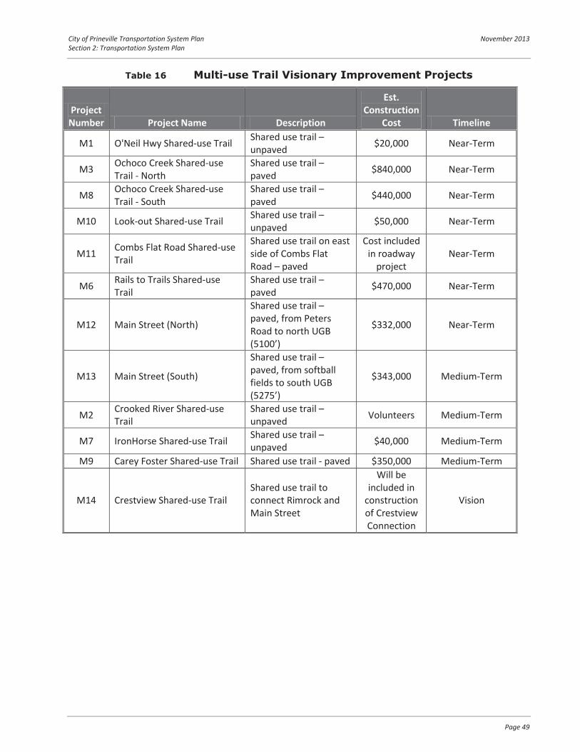
City of Prineville Transportation System Plan November 2013 Section 2: Transportation System Plan
Page 49
Table 16 Multi-use Trail Visionary Improvement Projects
Project Number Project Name Description
Est. Construction
Cost Timeline
M1 O'Neil Hwy Shared-use Trail Shared use trail – unpaved $20,000 Near-Term
M3 Ochoco Creek Shared-use Trail - North
Shared use trail – paved $840,000 Near-Term
M8 Ochoco Creek Shared-use Trail - South
Shared use trail – paved $440,000 Near-Term
M10 Look-out Shared-use Trail Shared use trail – unpaved $50,000 Near-Term
M11 Combs Flat Road Shared-use Trail
Shared use trail on east side of Combs Flat Road – paved
Cost included in roadway
project Near-Term
M6 Rails to Trails Shared-use Trail
Shared use trail – paved $470,000 Near-Term
M12 Main Street (North)
Shared use trail – paved, from Peters Road to north UGB (5100’)
$332,000 Near-Term
M13 Main Street (South)
Shared use trail – paved, from softball fields to south UGB (5275’)
$343,000 Medium-Term
M2 Crooked River Shared-use Trail
Shared use trail – unpaved Volunteers Medium-Term
M7 IronHorse Shared-use Trail Shared use trail – unpaved $40,000 Medium-Term
M9 Carey Foster Shared-use Trail Shared use trail - paved $350,000 Medium-Term
M14 Crestview Shared-use Trail Shared use trail to connect Rimrock and Main Street
Will be included in
construction of Crestview Connection
Vision

nm
!r
õôónm
!.!
jg nm
nm
ÂK
nmIH
s
õôó
õôó
õôó
õôó
õôóõôó
"Z
õôó
õôó
õôó
õôóõôó
kl89:mkl89:mkl89:m
kl89:m
kl89:m
kl89:m
kl89:m
G
G
G
G
G
G
G
M8
M10
M6
M11
M12
M13
M14
M3
G
M7
M1
M2
M2
M9
Vision Plan
Vision Plan
S M
AIN
ST
SE C
OM
BS
FLA
T R
D
SE LYNN BLVD
N M
AIN
ST
NE
YELL
OW
PINE
RD
NE MARIPOSA AVE
NW 3RD ST
NW
HA
RW
OO
D S
T
NE 3RD ST
NW 10TH ST
NW 3RD ST
NWLAMONTA RD
NEBA
RNES
RD
NE BARNES BUTTE RD
SWTO
MM
CC
ALL
RD
SW HOUSTON LAKE RD
SE JUN
IPER C
ANYO
N R
D
SW12
6HW
Y
NW MADRAS HW
Y
SE PAULINA HWY
NWO'NEIL HWY
UV126
UV380
UV370
£¤26
£¤26
SW A
IRPORT
RD
SE 3RD ST
NE 13TH ST
SW
DE
ER
ST
SE 6TH ST
NE
ELK
ST
NW GARDN
ER
RD
SW PARK DR
NE
ELM
ST
NE SUNRISE ST
NE RAWHIDE LN
NE
OR
EG
ON
AVE
NE
TEN
NE
SSEELN
NE
MC
RA
E C
T
NE LOPER AVE
NW 9TH ST
SE LINCOLN RD
SW AVIATION BLVD
NW APOLLO RD
NW 12TH ST
SE W
ILLO
WD
ALE
DR
NE
SU
GA
RP
INE
RD
SE MELROSE DR
NW 2ND ST
NE OCHOCO AVE
SE S
TEA
RN
S R
D
NW MCDONALD RD
NE
CO
UR
T S
T
NW 4TH ST
NW 6TH ST
NW
RO
LLO
RD
NE OWENS RD
NW 5TH ST
NE 7TH ST
SE 7TH ST
NE 6TH ST
SW 4TH STSE
DU
NH
AM
ST
NW 8TH ST
SE
GA
RN
ER
ST
NW
EW
EN
ST
SE
KN
IGH
T S
T
NE 2ND ST
NW 7TH ST
SE 2ND ST
SE E
LM S
T
SE
HO
LLY
ST
NE
BE
LKN
AP
ST
NE 4TH STN
W D
EE
R S
T
NW
CLA
YP
OO
LS
T
E 1ST ST
SE
CO
UR
T S
T
NW
BE
AVE
R S
T
NE
JU
NIP
ER
ST
SW
RIM
RO
CK
RD
NW PEPPERMINT LN
SW CRESTVIEW RD
SE HILL ST
SW EMPIRE DR
NW GUMPERT RD
SEBULL
BLVD
NW WEST HILLS RD
SW
EW
EN
ST
NWBR
OO
KFI
ELD
LN
NW
CE
NTU
RY
DR
NE LAUGHLIN RD
SWHIG
HDESERT DR
NW
LON
SM
ITHR
D
NWPINEC
REST
DR
NW RIMROCK ACRES LOOP
NWPEAC
OC
KW
ALK
SE CAREY FOSTER RD
SW LANDFILL RD
NETR
AVE
RS
EL N
SW
CO
MM
ER
CE
CT
SWCO
NN
ECT
WAY
SW
BA
LDW
IN R
D
NE
WAY
FIN
DE
RD
R
Undefined
Route*
Sources: Esri, USGS, NOAA
¯
Figure
10
Destinations"Z Airport
jg Fairgrounds
s Golf Course
ÂK Hospital
IH Library
!r Pool
nm School
!.! Skatepark
õôó Park
kl89:m Proposed Ped Crossing
Existing Multi-Use Path
Proposed Paved Multi-UsePath
Proposed Unpaved Multi-Use Path
City Boundary
Study Area/Urban GrowthBoundary (UGB)
K:\H
_Por
tland
\pro
jfile
\122
21 -
Prin
eville
TSP
\gis
\Dra
ft TS
P\8-
10-S
hare
d us
e Tr
ails
.mxd
- ag
riffin
- 4
:30
PM 1
2/12
/201
3
Coordinate System: NAD 1983 HARN StatePlane Oregon South FIPS 3602 Feet Intl
Visionary Shared-use Path ImprovementsCity of Prineville, Oregon
UV126
UV380
£¤26£¤26
UV27
CROOK COUNTY
0 0.35 0.7 Miles
Prineville TSP

City of Prineville Transportation System Plan November 2013 Section 2: Transportation System Plan
Page 51
Safety Improvement Projects
Future transportation projects should incorporate strategies to improve the long-term safety of the Prineville transportation system, with an emphasis on reducing crashes along Third Street and at other high priority locations, as identified by the City. Table 17 summarizes safety-related projects to serve long-term multi-modal needs throughout the community. Several of these improvements can be readily implemented with signing and striping, and can be implemented as part of routine maintenance efforts. The City should continue to periodically monitor the system to gauge progress were improvements have been completed and identify emerging trends.
Table 17 Safety Projects
Location Potential Modifications
N 3rd Street: Maple to Claypool Reduce driveway density through access closure and/or consolidation.
N 3rd Street/ Harwood Street Reduce congestion through development of parallel routes and conflict areas on N 3rd Street through access closure and/or consolidation.
N 3rd Street/ Combs Flat Road Provide a roadside environment east of Knowledge that will support reduced speeds. Provide dedicated north-south left-turn lanes and consider protected-only signal phasing during peak time periods.
Main Street/ N 4th Street
Improve driver awareness at the N 3rd Street/Main Street intersection through high visibility signal head treatments, and construction of parallel routes. Consider pedestrian crossing treatments such as higher-visibility crosswalks and curb bulb-outs.
N 2nd Street/ Deer Street
Increase sign visibility through one or more of the following: replace the stop sign with a larger size sign, install high-reflectivity tape on the sign post, or add LED lights to the sign border, improve crosswalk and stop bar striping. Alternatively, consider conversion of the intersection to all-way stop control.
Transit System Projects
Regional transit service is provided from the park-and-ride facility located within the gravel shoulder area of the Prineville “Y”. This site has poorly defined access and lacks basic amenities that would make this site comfortable and convenient, such as lighting, striped parking spaces, and better separation from the state highway. Due to these constraints, relocation of the park-and-ride facility is a near-term priority for Cascades East Transit (CET) and the City of Prineville. Central Oregon Intergovernmental Council (COIC) has published the ODOT Region 4 Park and Ride Lot Plan that identifies seven alternative park and ride sites within Prineville. The Plan provides recommendations on the number of parking stalls, features, and amenities that will support the use of Park and Ride lots and transit services offered by CET. The Plan identifies priority locations for park and ride lots in several cities. In Prineville, the priority location is the parking lot at Erickson’s Thriftway, located at 315 NW 3rd Street, which is centrally located in the City. The Plan indicates the landowner is interested in the partnership. The lot currently has bike and pedestrian access, but several improvements would be needed for the park and ride lot, including signs, lighting, a transit shelter, and sidewalk improvements to meet ADA standards.

City of Prineville Transportation System Plan November 2013 Section 2: Transportation System Plan
Page 52
The 2013 COIC Regional Transit Master Plan indicates that 2013 population and employment density can support introduction of a “flexible” fixed-route service. The plan provides service concepts for local flex route services that could replace local public bus service that requires advanced reservations (previous day by 4 p.m.). The analysis in the Master Plan indicates that flex-route services would be cost-neutral (i.e., could be operated at the same cost as the existing dial-a-ride bus service).
Downtown Couplet Vision Project
Although not expected to be necessary within the next 20 years, a downtown couplet is likely to be needed in the future to accommodate growth in traffic along 3rd Street. In order to prepare for this future project, the City should begin considering location options for the couplet in order to proactively reserve right-of-way and encourage complementary development.
There are two options for a downtown couplet, as identified in Figure 11 and Figure 12. Figure 11 shows a potential alignment option for a couplet along NE 2nd Street and 3rd Street. Figure 12 shows potential alignments of a couplet along 3rd Street and NW 4th Street. Although these figures are conceptual and not reflective of design alternatives, they are meant to highlight several important considerations that should be weighed in deciding the location of the future couplet. These considerations include:
Ability to expand downtown: What is the existing land use along NE 2nd Street and NW 4th Street? Would one have better potential to expand downtown to two streets? Rezoning/redevelopment opportunities: Are there opportunities to redevelop the land along NE 2nd Street or NW 4th Street, or do constraints such as parks prevent this redevelopment? Impacts to adjacent land uses: What impacts would a couplet have on the adjacent land use, including commercial areas and public parks? Impacts to natural areas: Does the couplet impact natural parks, creeks, flood plains, etc? Ability to develop in phases: Is there potential to develop the couplet in phases, by completing sections as the right-of-way becomes available? Connectivity to the highway/roadways: How does the couplet connect with the surrounding roadway system, primarily at the termini? Natural or man-made barriers: What creeks or other barriers exist that will impact the cost of constructing the couplet?
The City should consider all of these factors in deciding what the preferred alignment is for the potential future couplet. The couplet will have a significant impact on the downtown core, and careful consideration of the preferred alignment is important to ensure that the couplet leads to economic growth of the City and the downtown area.

H H H H H
HH H H H H H
H H HH H
H H
SE C
OM
BS
FLA
T R
D
SE LYNN BLVD
S M
AIN
ST
N M
AIN
ST
NW 3RD ST
NE 10TH ST
NW
HA
RW
OO
D S
T
NW 10TH ST
NE 3RD ST
NW 10TH ST
NW3RD ST
NWLAMONTA RD
NW MADRAS HWY
NW
MADRAS HWY
NWO'NEIL HWY
SW 126 H
WY
UV126
UV380
UV370
£¤26 NW
LO
CU
ST
ST
NE
HU
DS
PE
TH L
N
SW
DE
ER
ST
SE 5TH ST
SE 6TH ST
NE
PO
WE
LLLN
NE BOXCAR DR
SE MELROSE DR
SE LINCOLN RD
SW PARK DR
NE
ELM
ST
NE
JOR
DA
NLN
NW DODSON D
R
NE
DE
LR
IOA V
E
NE
OR
EG
ON
AV
E
SW
CLA
YP
OO
LS
T
NE
WIL
SH
IRE
DR
NE
WH
ISTL
E W
AY
SW MEADOW LAKES DR
NE
MC
RA
E C
T
NE CREST DR
NE HILLSIDE WAY
NE
DISCO
VERY
LOOP
NE
DU
NH
AM
ST
NW 9TH ST
NE MASON DR
NW 12TH ST
NW 2ND ST
SW
BE
AVE
R S
T
SE LESLIE LN
SW
CLI
FFS
IDE
LN
NE ALLEN AVE
NE LOOKOUT AVE
NE PERSPECTIVE DR
NE OCHOCO AVE
SE
BA
ILE
Y R
D
NE
PIS
TON
WAY
NE
CO
UR
T S
T
SE
FA
IRV
IEW
ST
NW 4TH ST
SE K
NO
WLE
DG
E S
T
NW 6TH ST
NE HUDSPETH RD
NW 5TH ST
NE LOPER AVE
NE
GA
RN
ER
ST
NE 7TH ST
SE 7TH ST
NE 6TH ST
NE
IDLE
WO
OD
ST
SW 4TH ST
SW 5TH ST
W 1ST ST
SE 4TH ST
SE
DU
NH
AM
ST
NW 8TH ST
SE G
AR
NE
R S
T
NW
EW
EN
ST
SE
IDLE
WO
OD
ST
SE
KN
IGH
T S
T
NE 2ND ST
NW 7TH ST
SE
BE
LKN
AP
ST
SE 2ND ST
SE E
LM S
T
NE
HO
LLY
ST
NW
FA
IRM
ON
T S
T
NE 5TH ST
SE
HO
LLY
ST
NE
BE
LKN
AP
ST
NE 4TH ST
NW
DE
ER
ST
NW
ME
AD
OW
LA
KE
S D
R
NW
CLA
YP
OO
LS
T
E 1ST ST
SE 3RD ST
SE
CO
UR
T S
T
NW
BE
AVE
R S
T
NE
JU
NIP
ER
ST
NE
FA
IRV
IEW
ST
SW
RIM
RO
CK
RD
NE 8TH ST
NE 5 1/2 ST
SW 2ND ST
SW 3RD ST
SE
JU
NIP
ER
ST
SW CRESTVIEW RD
NE
TR
ES
TLE
ST
NW CAINS RD
SE
PA
LIN
LN
SE 8TH ST
NE LAUGHLIN RD
SW
IVY
CT
SE HYLTON LN
SE COLBY CT
NW MARKUSON D
R
SW E
WE
N S
T
SE
ALG
ON
QU
IAN
CT
NE LITTLETON LN
NEDE
LNO
RTE
AVE
SE KRAMER LN
NE
KN
OW
LED
GE
ST
NE
OC
HO
CO
PLA
ZAD
R
NE
CO
MB
S F
LAT
RD
SE
FA
IRG
RO
UN
DS
RD
SE CAREY FOSTER RD
SE
CA
LVIN
WAY
NW STUDEBAKER DR
NE
UN
ION
LO
OP
Sources: Esri, USGS, NOAA
Prineville TSP
¯
Figure
11
Couplet
City Boundary
Study Area/Urban GrowthBoundary (UGB)
K:\H
_Por
tland
\pro
jfile
\122
21 -
Prin
eville
TSP
\gis
\Dra
ft TS
P\6-
6 2n
d &
3rd
Stre
et C
oupl
et.m
xd -
agrif
fin -
11:
36 A
M 9
/26/
2013
Coordinate System: NAD 1983 HARN StatePlane Oregon South FIPS 3602 Feet Intl
2nd and 3rd Street CoupletCity of Prineville, Oregon
UV126
UV380
£¤26£¤26
UV27
CROOK COUNTY
0 0.1 0.2 Miles
Alignment Option A
Alignment Option B

H H H H H
H H H H
H
H HH
H
H
Alignment Option B
SE C
OM
BS
FLA
T R
D
SE LYNN BLVD
S M
AIN
ST
NW 3RD ST
NE 10TH ST
NW
HA
RW
OO
D S
T
NW 10TH ST
NE 3RD ST
NW 10TH ST
NW3RD ST
NWLAMONTA RD
N M
AIN
ST
NWO'NEIL HWY
NW MADRAS HW
Y
SW 126 H
WY
NW
MADRAS HWYUV370
UV126
£¤26
SW R
IMR
OC
K R
D
NE 13TH ST
NW
LO
CU
ST
ST
NE LAUGHLIN RD
NE
HU
DS
PE
TH L
N
SW
DE
ER
ST
SE 5TH ST
SE 6TH ST
NE BOXCAR DR
NW WESTERN SKY RD
NE SUNRISE ST
SW PARK DR
NE
ELM
ST
NE
JOR
DA
NLN
NW DODSON D
R
NE
DE
LR
IOAV
E
NE
OR
EG
ON
AV
E
SW
CLA
YP
OO
LS
T
NE
WIL
SH
IRE
DR
NE
WH
ISTL
E W
AY
SW MEADOW LAKES DR
NE
MC
RA
E C
T
NE CREST DR
NE HILLSIDE WAY
NE LOPER AVE NE
DISCO
VERY
LOOP
NE
DU
NH
AM
ST
NW 9TH ST
NE MASON DR
NW 12TH ST
NW 2ND ST
SW
BE
AVE
R S
T
SE LESLIE LN
SW
CLI
FFS
IDE
LN
NE ALLEN AVE
NE LOOKOUT AVE
NE PERSPECTIVE DR
NE OCHOCO AVE
SE
BA
ILE
Y R
D
NE
PIS
TON
WAY
NE
CO
UR
T S
T
SE
FA
IRV
IEW
ST
NW 4TH ST
SE K
NO
WLE
DG
E S
T
NW 6TH ST
NE HUDSPETH RD
NW 5TH ST
NE
GA
RN
ER
ST
NE 7TH ST
SE 7TH ST
NE 6TH ST
NE
IDLE
WO
OD
ST
SW 4TH ST
SW 5TH ST
W 1ST ST
SE 4TH ST
SE
DU
NH
AM
ST
NW 8TH ST
SE G
AR
NE
R S
T
NW
EW
EN
ST
SE
IDLE
WO
OD
ST
SE
KN
IGH
T S
T
NE 2ND ST
NW 7TH ST
SE
BE
LKN
AP
ST
SE 2ND ST
SE E
LM S
T
NE
HO
LLY
ST
NW
FA
IRM
ON
T S
T
NE 5TH ST
SE
HO
LLY
ST
NE
BE
LKN
AP
ST
NE 4TH ST
NW
DE
ER
ST
NW
ME
AD
OW
LA
KE
S D
R
NW
CLA
YP
OO
LS
T
E 1ST ST
SE 3RD ST
SE
CO
UR
T S
T
NW
BE
AVE
R S
T
NE
JU
NIP
ER
ST
NE
FA
IRV
IEW
ST
NE 8TH ST
NE 5 1/2 ST
SW 2ND ST
SW 3RD ST
SE
JU
NIP
ER
ST
NE STEINS PILLAR DR
SW
CR
ES
TVIE
W R
D
NE
TR
ES
TLE
ST
NW CAINS RD
SE
PA
LIN
LN
SE 8TH ST
NE
PO
WE
LLLN N
E T
YLE
R S
T
SW
IVY
CT
SE HYLTON LN
SE MELROSE DR
NW MARKUSON D
R
SW
EW
EN
ST
NE LITTLETON LN
NEDEL
NORT
EAV
ESE KRAMER LN
NE
KN
OW
LED
GE
ST
NE
OC
HO
CO
PLA
ZAD
R
NE
CO
MB
S F
LAT
RD
NW
PIN
CK
AR
D L
N
SE
CA
LVIN
WAY
NW STUDEBAKER DR
NW
SE
EH
ALE
AV
E
NE
UN
ION
LO
OP
Sources: Esri, USGS, NOAA
Prineville TSP
¯
Figure
12
Couplet
City Boundary
Study Area/Urban GrowthBoundary (UGB)
K:\H
_Por
tland
\pro
jfile
\122
21 -
Prin
eville
TSP
\gis
\Dra
ft TS
P\6-
7 3r
d &
4th
Stre
et C
oupl
et.m
xd -
agrif
fin -
10:
06 A
M 9
/6/2
013
Coordinate System: NAD 1983 HARN StatePlane Oregon South FIPS 3602 Feet Intl
3rd & 4th Street CoupletCity of Prineville, Oregon
UV126
UV380
£¤26£¤26
UV27
CROOK COUNTY
0 0.1 0.2 Miles
Alignment Option A

City of Prineville Transportation System Plan November 2013 Section 2: Transportation System Plan
Page 55
Sustainability Plan
This section documents the City of Prineville’s efforts towards creating a sustainable transportation system. The key elements of Prineville’s plan include the City’s efforts to improve facilities for non-motorized transportation and to encourage integration between transportation and land use. These efforts are revealed in the prioritization of projects for pedestrians and bicyclists throughout the City and its focus on integrating transportation and land use, especially through the new mixed-use area located on the Ochoco Lumber site.
An effective way of creating a sustainable city, especially in smaller cities such as Prineville, is to create continuous facilities for pedestrians and bicyclists, including a network of sidewalks, pedestrian crossings, bicycle lanes, and shared-use paths. Significant barriers to walking and bicycling often include roadway design, access to transit, and land use patterns. When the City updated its Development Code in 2011, significant changes were made to allow and encourage mixed use development, in part to reduce vehicle trips on the City’s transportation system. Priority projects for pedestrians and bicyclists identified in the TSP include projects that connect residential areas to this mixed use area, schools, commercial, and office locations in an effort to integrate transportation facilities with appropriate land use categories. By prioritizing these facilities, the City is working towards reducing barriers to walking and bicycling for local trips.
The City’s Transportation Impact Analysis Requirements also reflect the efforts to improve pedestrian and bicyclist facilities throughout the City. Section 3.3, Mitigation, states that:
“Any incremental transportation improvement must also accommodate bike and pedestrian movements, consider broader and multimodal system impacts, and minimize unnecessary construction impacts to the public. Safety or multimodal system mitigations can be considered in lieu of operational mitigations, upon approval by City engineer.”
With these policies, the City is further encouraging private development to assist in the completion of continuous facilities throughout the City in order to reduce barriers to walking and biking for residents of Prineville.
Downtown Parking
The City of Prineville completed a downtown parking plan in 1997, titled Downtown Prineville Street Improvement Project. The purpose of the project was to beautify the City, increase its functionality, and address the effects of “piecemeal” development infill. The study assessed the central business district along 3rd Street from Deer Street to Fairview, and between South 2nd and Ochoco Creek (totaling 44 City blocks).
At the time the plan was completed the City’s 1994 Transportation System Plan had identified the need for a US 26/OR 126 couplet along 3rd Street and 4th Street. The plan considered infrastructure needs to support the changes to these roadways as well as improvements to 3rd Street that would maintain the

City of Prineville Transportation System Plan November 2013 Section 2: Transportation System Plan
Page 56
current section. At the time, 3rd Street had already been converted to its current 3-lane cross-section, though the condition of sidewalks and curb ramps was much poorer than it is today.
The options recommended in the plan identified improvements to the streetscape that would include more trees, planter areas, improvements to sidewalk conditions, installation of bicycle parking, trash receptacles, and curb bulb-outs that would better define the parking areas. Some of the other elements included better defining driveways, narrowing the width, and using alleys and alternative access locations to reduce conflict points and increase the available parking supply. Employee parking was recommended for consolidation in City-owned off-street parking lots to free up space for visitors.
Within this Transportation System Plan the findings and recommendations of the Downtown Prineville Street Improvement Project remain relevant. Retaining the same roadways sections on 2nd, 3rd, and 4th Street as were present in 1997 will allow these prior recommendations to largely remain unchanged. Due to more recent changes in ODOT policy, the recommended curb bulb-outs on the State Highway may become limited to intersections with local streets so that truck maneuvers are not limited on the higher-order facilities. The ability to retain the two-way travel patterns that this plan is premised on continues to leave opportunities to improve the parking supply on north-south roads in the downtown core, and to retain (or possibly extend) the angled parking on 2nd and 4th Streets.
RAIL, AIR, PIPELINE, & SURFACE WATER PLANS The following addresses the rail, air, pipeline, and surface water networks in the City of Prineville. This plan does not include improvement projects for these systems given that the City does not have jurisdiction to make modifications.
Rail
The City of Prineville Railway (COPR) provides a primary freight connection between the City and the Class 1 BNSF mainline in Redmond. This 18-mile shortline includes daily switching operations at the Prineville Junction located just north of Redmond along the US 97 corridor.
With the closure of the Ochoco Mill, the City recently abandoned a City-operated spur rail line between Main Street and Combs Flat Road, converting the right-of-way into a trail. The abandonment of this rail line removed eight at-grade rail crossings within the City, including a crossing of US 26, Combs Flat Road (OR 380), and Main Street.
Despite the abandonment of the spur line, the City has increased its investment in the COPR shortline service to the Prineville Junction. With assistance from Connect Oregon grants, the City recently completed construction of a freight depot providing warehousing space, equipment ramps, freight to rail intermodal service, and bulk product storage. The site is located along Bus Evans Road between Lamonta Road and US 26, approximately two miles west of the City.

City of Prineville Transportation System Plan November 2013 Section 2: Transportation System Plan
Page 57
The location of this site and its intermodal infrastructure further justifies the City freight route designation of Lamonta Road which provides access to Bus Evans Road. Coordination with Crook County should be pursued to similarly classify the portion of Lamonta Road located outside of City limits.
Air Service
Proposed connections between Tom McCall Road and Airport Road will provide off-highway connectivity to improve integration of the business park with the airport. Additionally, airport traffic will have improved access to OR 126 with traffic control improvements proposed at the Tom McCall Road intersection. The City and Crook County are preparing to update the airport master plan, which will identify additional improvement needs over the planning horizon.
Preserving access to the airport will remain a City priority, and improvement plans at the OR 126/Tom McCall intersection and its associated frontage road system will retain this access and improve its long-term operations.
Surface Water Transportation
No navigable waterways exist within Prineville. The Ochoco Creek and Crooked River run through the city limits. Neither are used for transportation purposes.
Section 3 Transportation Planning Toolbox

City of Prineville Transportation System Plan November 2013 Section 3: Transportation Planning Toolbox
Page 59
TRANSPORTATION PLANNING TOOLBOX This section summarizes a range of transportation-related strategies and solutions that can guide the City of Prineville as it continues to grow and develop. These “tool box” measures fall into the following categories:
“Active” transportation (i.e., walking, cycling, and transit) Connectivity of the transportation network Intersection control Neighborhood traffic calming
The solutions in this toolbox are intended to provide ideas and options to the community as future infrastructure improvement options are developed.
INCREASING “ACTIVE” TRANSPORTATION As Prineville continues to develop, modal choices, such as walking, biking, and transit should be encouraged as a means to reduce single occupancy vehicle (SOV) trips. Walking and biking can be encouraged through interconnected routes between employment centers, retail, the downtown, and residential lands. Transit can be encouraged through provision of enhanced service (reduced headways, more stop locations, etc.) or providing flexible routes that serve a greater portion of the population and employment areas.
The following subsections outline guidelines and approaches to providing pedestrian and bicycle options for transportation system users. Transit suggestions are provided in the COIC Regional Transit Master Plan.
Pedestrian System
Pedestrian facilities are the elements of the network that enable people to walk safely and efficiently between neighborhoods, retail centers, employment areas and transit stops. These include facilities for pedestrian movement along key roadways (e.g., sidewalks, mixed-use trails) as well as for safe roadway crossing locations (e.g., crosswalks, crossing beacons, pedestrian refuge islands). Each plays a role in developing a comprehensive pedestrian network.
Today, pedestrian facilities within Prineville are not fully interconnected, and outside of the downtown area are incomplete and sporadic. Pedestrian facilities that do exist often include utility encroachments,

City of Prineville Transportation System Plan November 2013 Section 3: Transportation Planning Toolbox
Page 60
numerous driveway conflicts, or inadequate width. These conditions limit the comfort, safety, and utility of the pedestrian facilities. In the future, as arterials and collector streets are improved to urban standards, improvements to existing pedestrian routes (as sidewalks and/or multi-use pathways) will be provided. New roadways require pedestrian infrastructure.
Sidewalks
All trips begin and end with a walking component, and sidewalks are the fundamental building block of the transportation system enabling people to comfortably, conveniently and safely walk to and from their destinations. They provide an important means of mobility for people with disabilities and families with strollers, and others who may not be able to travel on an unimproved roadside surface. Sidewalks are usually constructed from concrete and they provide an area separated from the roadway by a curb, landscaping, and/or on-street parking.
Types of Pedestrian Crossings
Crossing facilities enable walkers to safely cross streets, railroad tracks, and other transportation facilities. Planning for appropriate pedestrian crossings requires the community to balance vehicular mobility needs with providing crossing locations that are along the desired routes of walkers. Within Prineville, the major roadway facilities such as US 26, Main Street, and Combs Flat Road serve as barriers.
The state of Oregon considers all roadway intersections to be legal crossing locations for pedestrians regardless of whether a painted crosswalk is provided. At these locations, drivers are required to yield the right of way to pedestrians to allow them to cross. Driver compliance to yielding is often inconsistent and pedestrians often have difficulty crossing higher volume and higher speed roadways. Observations in Prineville show much higher yielding west of Knowledge Street where the posted speeds are lower and urban densities are higher. There are several different types of pedestrian crossing treatments that can be applied; each of these is applicable under a different range of considerations.
A brief description of the various pedestrian crossing types and where they can be applied is provided below.
Exhibit 2 Sidewalks in a variety of urban and suburban contexts.

City of Prineville Transportation System Plan November 2013 Section 3: Transportation Planning Toolbox
Page 61
High Visibility Crosswalk
Clear, reflective roadway markings and accompanying devices are placed at intersections and priority pedestrian crossing where there is sufficient sight distance and reaction time for motorists to yield. Crosswalks can be used at intersections and at mid-block crossings. Curb bulb-outs can be used to restrict adjacent parking and increase pedestrian visibility prior to crossing.
Raised Pedestrian Refuge
A raised pedestrian refuge in the median provides a protected area in the middle of a crosswalk for pedestrians to stop while crossing the street. These refuge areas allow pedestrians to cross one direction of traffic at a time. Pedestrian refuges are often used in areas with high volume traffic volumes and/or at locations with a crash history involving pedestrians.
In-Street Yield
“Yield to Pedestrian” signs can be placed in the middle of crosswalks to increase driver awareness of crossing locations and the legal responsibility to yield right-of-way to pedestrians crossing the street. These signs can be effective in areas that experience high volumes of pedestrians making midblock crossings and/or at locations where there is poor motorist yielding rates. Installation of these signs needs to consider the maintenance needs, which can vary based on the types of vehicles and speeds.

City of Prineville Transportation System Plan November 2013 Section 3: Transportation Planning Toolbox
Page 62
Rapid Rectangular Flashing Beacon (RRFB)
These crossing treatments include signs that have a pedestrian-activated “strobe-light” flashing pattern to attract motorists’ attention and provide awareness of pedestrians that are intending to cross the roadway. RRFBs are often used in areas with high volumes of pedestrians desiring to cross a street at a mid-block location. RRFBs are warning signs designed to increase driver yielding, but they do not obligate a driver to stop. RRFBs should be located only in areas with the greatest safety risk for pedestrian to avoid over signing and noncompliance of motorists. Costs for an RRFB installation are generally in the $10,000 to $50,000 range depending on the cross-section and hard-wired or solar installation.
Pedestrian Hybrid Beacon (HAWK)
A HAWK is a pedestrian-activated signal, unlit when not in use, that begins with a yellow light alerting drivers to slow, and then a solid red light requiring drivers to stop while pedestrians have the right-of-way to cross the street. HAWKs are often used on wide roadways where mid-block crossings are difficult. The lack of HAWK signals in Central Oregon would require more driver education than similar treatments such as the RRFB, and are a more expensive treatment costing approximately $100,000.
Bicycle System
Bicycle facilities enable cyclists to travel safely and efficiently on the transportation system. Both public infrastructure (wide shoulders, bicycle lanes, cycletracks, multi-use trails, signage and striping) and “on-site” facilities (secure parking, changing rooms and showers at worksites) are important to providing a comprehensive bicycle network.
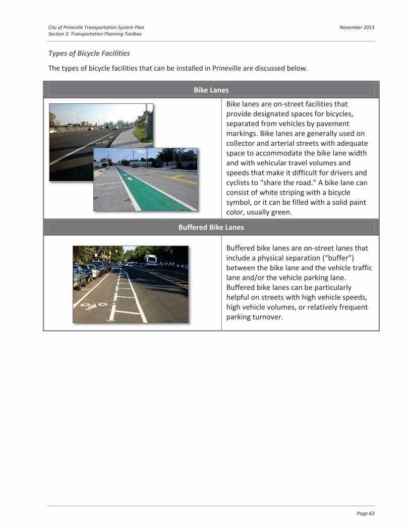
City of Prineville Transportation System Plan November 2013 Section 3: Transportation Planning Toolbox
Page 63
Types of Bicycle Facilities
The types of bicycle facilities that can be installed in Prineville are discussed below.
Bike Lanes
Bike lanes are on-street facilities that provide designated spaces for bicycles, separated from vehicles by pavement markings. Bike lanes are generally used on collector and arterial streets with adequate space to accommodate the bike lane width and with vehicular travel volumes and speeds that make it difficult for drivers and cyclists to “share the road.” A bike lane can consist of white striping with a bicycle symbol, or it can be filled with a solid paint color, usually green.
Buffered Bike Lanes
Buffered bike lanes are on-street lanes that include a physical separation (“buffer”) between the bike lane and the vehicle traffic lane and/or the vehicle parking lane. Buffered bike lanes can be particularly helpful on streets with high vehicle speeds, high vehicle volumes, or relatively frequent parking turnover.

City of Prineville Transportation System Plan November 2013 Section 3: Transportation Planning Toolbox
Page 64
Cycletracks
Cycletracks are exclusive bikeways separated from vehicle travel lanes, parking lanes and sidewalks. In these contexts, vehicular parking is provided adjacent to traffic lanes whereas the bikeway is located adjacent to the curb. They can be one- or two-way in direction and can be even with the street, the sidewalk, or somewhere between. On existing streets, cycletracks can be constructed where there is sufficient roadway width and/or in areas where the number of vehicular travel lanes can be reduced.
Sharrows
A shared-lane marking, or sharrow, is a pavement marking that can be used where space does not allow for a bike lane and/or where vehicular travel speeds and volumes allow cyclists to comfortably and conveniently “share the road” with motorists. Sharrows remind motorists of the presence of bicycles and indicate to cyclists where to safely ride within the roadway.
Low-Traffic Bikeway
Also known as “bicycle boulevards,” streets with low vehicular volumes and speeds can be optimized for bicycle travel by including treatments for traffic calming and traffic reduction, signage and pavement markings, and intersection crossing treatments. Bike boulevards are ideal on local streets that parallel larger, high traffic routes and provide connections to similar destinations.

City of Prineville Transportation System Plan November 2013 Section 3: Transportation Planning Toolbox
Page 65
Wayfinding Signage
Wayfinding signs can direct bicyclists and pedestrians towards key destinations both within the city as well as to neighboring communities. These signs often include the distance to the destination and/or average travel times. Wayfinding signs are generally used on primary bicycle routes and multi-use trails.
“Share the Road” Signs
“Share the Road” signs can be used to remind drivers to watch for bicyclists on roadways without on-street bicycle lanes. However, the signs are not meant as a replacement for using the other facility types listed in this table.

City of Prineville Transportation System Plan November 2013 Section 3: Transportation Planning Toolbox
Page 66
Bicycle Crossings
Bicycle crossing treatments connect bike facilities at high traffic intersections, trailheads, or other bike routes. Frequently-used crossing treatments are shown below.
Marked Bicycle Detectors at Traffic Signals
Many traffic signals are “actuated”, meaning that a green light is provided to a particular intersection approach only when a vehicle is detected on that approach. However, actuating a signal as a cyclist is difficult if no indication is given of the location of detection equipment. Pavement markings can show cyclists where to stand to actuate a signal. Additionally, the sensitivity of all traffic signal loop detectors should be set to allow for bicycle activation. At intersections where bicyclists wait at an area separated from traffic, specific bicycle detectors can be installed.
Preferential Movement for Bicycles
Some intersections may be designed such that cars cannot make particular movements, but bicyclists can. This type of treatment allows greater connectivity for bicyclists.

City of Prineville Transportation System Plan November 2013 Section 3: Transportation Planning Toolbox
Page 67
Striping Through Intersections
At high-vehicle and/or high-bicycle volume intersections, extending bicycle lane striping through the intersection can alert drivers to look out for bicyclists traveling through the intersection and indicate right of way to bicyclists.
On-Site Facilities
Bicyclists also benefit from facilities that are located on-site within key employment, commercial and institutional locations. These facilities can include indoor and/or outdoor secure bicycle parking, open or covered U-shaped racks, showers/changing rooms, and storage lockers for clothing and gear. The City can use incentives to encourage developers to include these types of facilities in new buildings.
Multi-Use Pathways
Paved, bi-directional multi-use pathways can be designed as part of a park and recreational system and/or can be constructed adjacent to roadways where the topography, right-of-way, or other issues don’t allow for the construction of sidewalks and bike facilities.
Intersections of multi-use paths and roadways require crossing treatments that are well-marked and highly visible to vehicles and trail users. Multi-use pathways can be used to create longer-distance links within and between communities, provide regional connections and play an integral role in recreation, commuting, and accessibility for residents due to their broad appeal to users of all ages and skill levels.

City of Prineville Transportation System Plan November 2013 Section 3: Transportation Planning Toolbox
Page 68
CONNECTIVITY A well connected grid network of streets provides for convenient travel for vehicles, pedestrians and cyclists. Given an equivalent number of roadway lane-miles, a connected system generally has more capacity than a disconnected road network and provides the shortest, most direct routes. A grid network can also lessen the effects of congestion along a single route due to the number of alternatives available. A connected system also can create easier and more expedient emergency response and can encourage pedestrians and bicyclists, who benefit from having a direct route due to generally slower travel speeds. Exhibit 4-1 shows how someone might travel between their home and school on a well-connected grid network versus one that is a system of cul-de-sacs.
Exhibit 4-1: The left illustration is a connected street grid, on the right is a less connected system. Travel distance from home to school is shorter in a connected system.
INTERSECTION CONTROL Today, the majority of intersections within the City (outside of Main Street and 3rd Street) are stop-controlled. In the future, increasing traffic volumes may warrant different intersection options, such as
Exhibit 3 Multi-use paths provide a comfortable space for pedestrians and bicyclists of all ages.

City of Prineville Transportation System Plan November 2013 Section 3: Transportation Planning Toolbox
Page 69
Exhibit 3 Roundabouts have fewer conflict points than signalized intersections.
roundabouts, traffic signals, and all-way stop control. The type of intersection control and final design for each intersection will need to consider the desired travel speeds, safety, pedestrian and bicycle needs, topography, anticipated traffic volumes, sight distance, available space and other potential constraints and opportunities.
All-way Stop-control
All-way stop control is often used when the two intersecting roads have similar vehicular volumes and where a traffic signal or roundabout may be needed longer-term. All-way stop control is a relatively inexpensive treatment, and can be implemented more easily than traffic signals and roundabouts. This treatment is also useful where sight distance is limited or where there are a high number of angle crashes.
Roundabout
Roundabouts are circular intersections where entering vehicles yield to vehicles already in the circle. They are designed to slow vehicle speeds to 20 to 30 mph or less before they enter the intersection. As shown in Exhibit 3, roundabouts have fewer conflict-points and have been shown to reduce the severity of crashes, as compared to signalized intersections. Roundabouts have shown to be safer for pedestrians than signalized intersections. Roundabouts can be more costly to design and install when compared to other intersection control types, but they have a lower operating and maintenance cost than traffic signals. Topography must be carefully evaluated in considering a roundabout, given that slope characteristics at an intersection may render a roundabout infeasible.
Depending on the design, roundabouts can be more land-intensive than other intersection controls. To maintain the flexibility to construct roundabouts at key intersections, the city may want to ensure

City of Prineville Transportation System Plan November 2013 Section 3: Transportation Planning Toolbox
Page 70
adequate right-of-way is provided at intersection locations whenever right-of-way dedication or acquisition activities are undertaken.
Traffic Signals
Traffic signals allow opposing streams of traffic to proceed in an alternating pattern. Both national and state guidance indicates when it is appropriate to install traffic signals at intersections. When used, traffic signals can effectively manage high traffic volumes, and provide for dedicated times in which pedestrians and cyclists can cross roadways. Because they continuously draw from a power source and must be periodically re-timed, signals typically have higher maintenance costs than other types of intersection control. Signals can improve safety at intersections where signal warrants are met, however, signals may result in a shift to higher levels of rear-end crashes compared to alternatives.
NEIGHBORHOOD TRAFFIC MANAGEMENT Neighborhood Traffic Management (NTM), also known as “traffic calming,” describes traffic control devices typically used in residential neighborhoods to slow traffic or possibly reduce the volume of traffic. Prineville’s wide local street sections lend themselves to higher travel speeds that could be managed through calming treatments. Below are illustrations and descriptions of neighborhood traffic management strategies that could be applied.
Speed Wagon Pros Cons
Inexpensive Low operating costs Mobile
Penalties for speeding not enforced Not permanent Placement may obstruct bicycle lane or shoulder
Speed Humps Pros Cons
Permanent Can be used to provide raised pedestrian crossings Can be modified to accommodate emergency vehicles
Placement of speed humps can be contentious Requires maintenance Creates difficulty for snow plows

City of Prineville Transportation System Plan November 2013 Section 3: Transportation Planning Toolbox
Page 71
Traffic Circles Pros Cons
Can have aesthetic value Physical barrier encourages lower speeds
Can impede emergency vehicles or freight/delivery truck movement Increased maintenance costs
Medians Pros Cons
Eliminates potential conflict points Can provide pedestrian refuge Can benefit access management
Can be more expensive to construct than other traffic calming measures Can impede roadway connectivity Can impact business access
Landscaping Pros Cons
Aesthetic value Provides buffer from vehicles for pedestrians Can have traffic calming effect Provides snow storage and runoff treatment areas Can accommodate utilities and maintain clear sidewalks
Requires additional maintenance, including weed management Requires additional right-of-way allocation Can impede sight distance

City of Prineville Transportation System Plan November 2013 Section 3: Transportation Planning Toolbox
Page 72
Curb Extensions Pros Cons
Reduces pedestrian crossing distance Can have a traffic calming effect Increases pedestrian visibility Contains parking away from the intersection corners
Can be expensive to construct Can impede freight movements May require modifications to existing drainage
Choker Pros Cons
Can be used in conjunction with a midblock pedestrian crossing Can have traffic calming effect
Expensive to construct
Narrow Streets Pros Cons
Reduces pedestrian crossing distance Can have a traffic calming effect Less asphalt to maintain Less runoff from impermeable surfaces
Can impede emergency vehicles Can limit availability of on-street parking

City of Prineville Transportation System Plan November 2013 Section 3: Transportation Planning Toolbox
Page 73
On-Street Parking Pros Cons
Increases available parking for commercial and/or residential uses Narrows feel of the street Potential revenue source if metered Can be reserved for visitors with time limitations
Adequate right-of-way must exist or be created Can conflict with bicycle lanes Can create additional conflict points for vehicles Can reduce sight distance
Selective Enforcement Pros Cons
Mobile Can target identified problem areas
Requires allocation of enforcement resources May only result in temporary improvement in motorist compliance with posted speeds
Partial Street Closures Pros Cons
Lack of direct through routes for vehicles can reduce speeds Maintain connectivity for bicycles and pedestrians
Can create connectivity issues May increase speeds on alternative routes May increase volumes on alternative routes Can create wayfinding issues
Traffic calming should be considered in an area-wide manner to avoid shifting impacts between neighborhoods and adjacent streets. Typically, traffic calming receives a favorable reception by residents adjacent to streets where vehicles travel at speeds above 30 miles per hour. However, traffic calming can also be contentious because it may be perceived as just moving the problem from one neighborhood to another rather than solving it. Traffic calming may also be perceived as impacting emergency vehicle travel.

Section 4 Transportation Funding and Implementation Plan

City of Prineville Transportation System Plan November 2013 Section 4: Transportation Funding and Implementation Plan
Page 75
TRANSPORTATION FUNDING AND IMPLEMENTATION PLAN Funding for the implementation of the projects identified in the Transportation System Plan will be shared between the City of Prineville, Crook County, ODOT, private development, and potentially through volunteers and other interests. The proportional contributions are to be determined at the time that development occurs or some land use change triggers the need for implementation. Contributions of each agency, if any, should reflect facility users’ residence and the project’s function. Facilities that are wholly located within the City, but utilized by County residents during daily commutes or to access necessary city amenities should include County contributions.
To assist with the future implementation efforts, this section of the TSP outlines the existing revenue stream for transportation funding in the City of Prineville, cost estimates for the recommended projects, and potential funding sources.
For the City of Prineville, there are four strategic considerations related to transportation funding:
The creation of parallel local routes to support the 3rd Street corridor can be accomplished through a strong partnership between ODOT, the City, the County, and the local landowners of the private lands that these new connections traverse. A variety of cost-sharing and funding mechanisms can be investigated as specific corridor strategies projects are identified. These mechanisms should include provisions for phasing of construction as well as potential reimbursement. The City’s existing transportation System Development Charge (SDC) program should be updated following adoption of the TSP. The City Council needs to carefully consider the implications on the future rate assessed on both economic development potential and the percentage of future transportation revenue needs that can be reasonably relied upon for funding by SDC. Development of the airport industrial lands provides the City with franchise fees and other revenue sources allocated to the City’s general fund. Continued development of these lands requires power, water, sewer, and transportation services; as such, an equitable methodology to allocate some of these funds to transportation infrastructure costs can be investigated by the city. Due to declining revenue, both traditional and non-traditional partnerships and funding sources should actively be pursued by the City of Prineville. This can include volunteer efforts to initiate trail construction, pursuance of grants, public/private partnerships, and coordination with State and County interests to help fund transportation projects.

City of Prineville Transportation System Plan November 2013 Section 4: Transportation Funding and Implementation Plan
Page 76
ESTIMATED REVENUE The City of Prineville has two primary sources for allocating funding for transportation projects: the Transportation SDC Fund and the Transportation Fund. The Transportation SDC Fund accounts for the receipt and expenditures of revenues to construct collector and arterial street improvements and is funded by SDC fees assessed on new development.
The primary sources of revenue for the Transportation Fund have been the State of Oregon gas tax and, to a lesser extent, state revenue sharing and the STP fund exchange program. Recognizing the impact that the installation of public utilities have on the need for street repairs, the City of Prineville recently established two new revenue sources for the Transportation Fund: franchise fees from the City’s water and wastewater funds. The Transportation Fund covers the City’s street, bike lane, right-of-way, and storm water maintenance.
Table 18 summarizes transportation-related resources and expenditures for the past three fiscal years as well as projections for the most recent fiscal year, which ended June 2013.
Table 18 Transportation Revenue
FY 09-10 FY 10-11 FY 11-12 FY 12-13 Transportation SDC Fund Resources $67,621 $199,206 $90,400 $150,800 Transportation SDC Fund Expenditures $167,256 $532,302 $114,200 $167,500
Transportation Fund Resources $888,715 $922,794 $903,661 $939,000 Transportation Fund Expenditures $972,131 $888,917 $1,155,300 $1,161,900
Based on the information provided in Table 18, the city has collected an average of $1.04 million per year in revenues (SDC and Transportation Fund) and expended approximately $1.3 million on average per year. Based on the past few years, the city may expect to collect approximately $25 million in transportation revenue over the next twenty years.
COST OF 20-YEAR NEEDS Review of the identified projects results in total project costs of approximately $41.0 million, which does not include right-of-way, on-going maintenance, or improvements to the City’s local streets.
The summary of project costs by near-, medium-, and long-term priority are shown in Table 19.
Table 19 Estimated Project Costs
Project Priority Estimated Construction Cost Long-term $7,130,000 Medium-term $19,460,000 Near-term $14,432,000 Grand Total $41,022,000

City of Prineville Transportation System Plan November 2013 Section 4: Transportation Funding and Implementation Plan
Page 77
Based on estimates of growth in Prineville, the estimated costs for near-term projects alone would exceed the expected SDC revenue over the 20-year period. Developing partnerships will be critical for the City’s funding, particularly as the design of the overall preferred alternative is premised on relieving the highway through creation of lower-cost City routes through undeveloped properties on the City’s north side, and within a built-environment south of 3rd Street.
Costs for near-term projects that the City will be required to fund are closer to $2 million, with much of these costs associated with sidewalk improvements throughout the City that were identified through Safe Routes to Schools or for connectivity purposes. Costs for multi-use pathways could be significantly reduced through volunteer efforts, initial trail creation with dirt surfaces, with successive enhancements provided over time.
LOCAL FUNDING MECHANISMS At the local level, the City can draw on a number of potential funding mechanisms to help finance the TSP improvements. A primary source of transportation revenue is through transportation System Development Charges (SDC).
As properties with road frontage develop, developers are currently required to build the road frontage along their property consistent with City standards. This allows the transportation system to be developed incrementally at the same time as land develops. System Development Charges require that developers pay for system improvements in proportion to their impacts on the transportation system. Transportation SDC revenue helps to offset transportation infrastructure costs, but SDC rates are not set to fully fund all of the projects within the Transportation System Plan. Table 20 summarizes the anticipated growth by sector in Prineville through the planning horizon in employment and housing, and provides an estimate of the number of trips this would generate.
Table 20 Estimated Project Costs
Growth Type 2010 to 2035 Growth Weekday PM Peak Hour Trips Employment 1,747 Employees 1,141 Agriculture 0 0 Industrial 955 401 Retail 317 353 Service 299 138 Education 71 138 Government 0 0 Other 105 111 Housing 1,647 Households 1,647 Total +2,788 Weekday PM Trips

City of Prineville Transportation System Plan November 2013 Section 4: Transportation Funding and Implementation Plan
Page 78
Based on the current City SDC fee ($3,051.21/PM peak hour trip), the existing SDC could raise approximately $8.5 million from growth occurring over the next 20-years. This revenue would be generated throughout the next 20-years, and may not be available to construct projects when needed.
Table 21 outlines other potential funding sources at the local level that could be implemented in the future in the City of Prineville. In general, local funding sources are more flexible than funding obtained from state or federal grant sources.
Table 21 Potential Local Funding Mechanisms
Funding Source Description Potential Application in Prineville
User Fee
Fees tacked on to a monthly utility bill or tied to the annual registration of a vehicle to pay for improvements, expansion, and maintenance on the street system.
Preliminary street improvements
Street Utility Fees/Road Maintenance Fee
The fee is based on the number of trips a particular land use generates and is usually collected through a regular utility bill.
System-wide transportation facilities including streets, sidewalks, bike lanes, and trails
Stormwater SDCs, Grants, and Loans
Systems Development Charges, Grants, and Loans obtained for the purposes of making improvements to stormwater management facilities.
Primarily street improvements
Local Gas Tax A local tax assessed on the purchase of gas within the City. This tax is added to the cost of gasoline at the pump, along with the state and federal gas taxes.
System-wide transportation facilities including streets, sidewalks, bike lanes, and trails
Optional Tax
A tax that can be used to fund improvements, and gives the taxpayer the option to pay. Generally paid at the same time other taxes are collected, optional taxes are usually less controversial and easily collected since they give the taxpayer a choice whether or not to pay the additional tax.
System-wide transportation facilities including streets, sidewalks, bike lanes, trails, and transit
Public/Private Partnerships
Public/private partnerships have been used in several places around the country to provide public transportation amenities within the public right-of-way in exchange for operational revenue from the facilities. These partnerships could be used to provide services such as charging stations, public parking lots, bicycle lockers, or carshare facilities.
System-wide transportation facilities including streets, sidewalks, bike lanes, trails, and transit
Tax Increment Financing (TIF)
A tool cities use to create special districts (tax increment areas) where public improvements are made in order to generate private-sector development. During a defined period, the tax base is frozen at the pre-development level. Property taxes for that period can be waived or
System-wide transportation facilities including streets, sidewalks, bike lanes, trails, and transit

City of Prineville Transportation System Plan November 2013 Section 4: Transportation Funding and Implementation Plan
Page 79
Funding Source Description Potential Application in Prineville
paid, but taxes derived from increases in assessed values (the tax increment) resulting from new development can go into a special fund created to retire bonds issued to originate the development or leverage future improvements. A number of small-to-medium sized communities in Oregon have implemented, or are considering implementing, urban renewal districts that will result in a TIF revenue stream.
Local Improvement Districts (LID)
A local improvement district is a geographic area where local property owners are assessed a fee to cover the cost of a public improvement in that area.
Improvements to the transportation system in a local area where local property owners will benefit from the improvement.
STATE AND FEDERAL GRANTS In addition to local funding sources, the City of Prineville can seek to leverage opportunities for funding from grants at the State and Federal levels for specific projects. The current Federal transportation bill, MAP-21, expires in September 2014, and funding opportunities may change after that date. Table 22 outlines those sources and their potential applications.
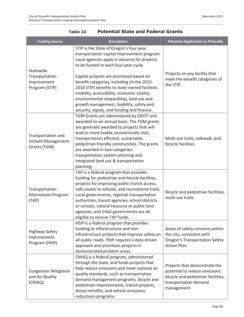
City of Prineville Transportation System Plan November 2013 Section 4: Transportation Funding and Implementation Plan
Page 80
Table 22 Potential State and Federal Grants
Funding Source Description Potential Application in Prineville
Statewide Transportation Improvement Program (STIP)
STIP is the State of Oregon’s four-year transportation capital improvement program. Local agencies apply in advance for projects to be funded in each four-year cycle.
Capital projects are prioritized based on benefit categories, including (in the 2015-2018 STIP) benefits to state-owned facilities, mobility, accessibility, economic vitality, environmental stewardship, land use and growth management, livability, safety and security, equity, and funding and finance.
Projects on any facility that meet the benefit categories of the STIP.
Transportation and Growth Management Grants (TGM)
TGM Grants are administered by ODOT and awarded on an annual basis. The TGM grants are generally awarded to projects that will lead to more livable, economically vital, transportation efficient, sustainable, pedestrian-friendly communities. The grants are awarded in two categories: transportation system planning and integrated land use & transportation planning.
Multi-use trails, sidewalk, and bicycle facilities.
Transportation Alternatives Program (TAP)
TAP is a federal program that provides funding for pedestrian and bicycle facilities, projects for improving public transit access, safe routes to schools, and recreational trails. Local governments, regional transportation authorities, transit agencies, school districts or schools, natural resource or public land agencies, and tribal governments are all eligible to receive TAP funds.
Bicycle and pedestrian facilities, multi-use trails.
Highway Safety Improvement Program (HSIP)
HSIP is a federal program that provides funding to infrastructure and non-infrastructure projects that improve safety on all public roads. HSIP requires a data-driven approach and prioritizes projects in demonstrated problem areas.
Areas of safety concerns within the city, consistent with Oregon’s Transportation Safety Action Plan.
Congestion Mitigation and Air Quality (CMAQ)
CMAQ is a federal program, administered through the state, and funds projects that help reduce emissions and meet national air quality standards, such as transportation demand management programs, bicycle and pedestrian improvements, transit projects, diesel retrofits, and vehicle emissions reductions programs.
Projects that demonstrate the potential to reduce emissions: bicycle and pedestrian facilities, transportation demand management.

Section 5 Implementation Ordinances

City of Prineville Transportation System Plan November 2013 Section 5: Implementation Ordinances
Page 82
IMPLEMENTATION ORDINANCES The following sections identify suggested implementation ordinances that the City will consider implementing.
ENCOURAGE A MIX OF USES IN RESIDENTIAL AND EMPLOYMENT AREAS The City updated its Development Code in 2011. Some of the most significant changes involved allowing and encouraging mixed uses, in part to reduce vehicle trips on the city’s transportation system. These changes include:
Adoption of a mixed-use zone, including both an employment mixed use zone (focus on industrial development with commercial and residential development scaled to support it) and a commercial mixed use zone (focus on mixing residential and commercial development). Greater flexibility for second floor residential uses in commercial areas. Greater ability for home occupations in residential areas along collector and arterial streets.
Additional steps the city could take to further encourage a mix of uses include:
Identify commercial uses compatible with city’s industrial zones and develop standards to locate and size these appropriately to serve the industrial areas (section 153.037 Commercial & Industrial Use Table and section 153.083 Standards for Specific Uses). Identify commercial uses compatible with city’s residential zones and develop standards to locate and size these appropriately to serve the residential area (section 153.035 Residential Use Table and section 153.083 Standards for Specific Uses). Identify residential uses that could be incorporated into industrial and/or commercial zones such as workforce housing, live/work developments, etc. and develop standards to locate/size these appropriately to fit in with and serve the employment/commercial area (section 153.037 Commercial & Industrial Use Table and section 153.083 Standards for Specific Uses). Review and evaluate the success of the mixed use zone provisions after finalizing the Ochoco Lumber Site zone change and make any amendments necessary to ensure it works as a tool to meet the mixed use zoning goals (section 153.063 Mixed Use MU Zone). Consider implementing an overlay map to identify potential areas in which to apply the existing neighborhood commercial zone, specifically outlying areas without convenient access to commercial areas. Consider alternatives to SDC fees as an incentive to encourage mixed use development

City of Prineville Transportation System Plan November 2013 Section 5: Implementation Ordinances
Page 83
STREET DESIGN OPTIONS A variety of street designs are needed within the community. Given Prineville’s location and proximity to riparian areas “Green Streets” may be a viable option. The city should develop green street designs consistent with federal regulations for stream protection. The city should establish standards for local streets and access ways that minimize pavement width and total ROW consistent with the operational needs of the community and transportation facilities.
PLAN FOR ALTERNATE MODES AND CONNECTIVITY In the 2011 Code Update, the city made several changes aimed at supporting future alternative modes of transportation, including:
Requiring transit stops to be a consideration in the newly created high density and mixed use zones Requiring bike parking with new commercial and industrial development and providing some vehicle parking relief for additional bike parking. Requiring sidewalks in industrial areas
The city has seen a significant increase in the use of alternative modes of transportation in the past decade, particularly with the establishment of Cascades East Transit services but also a noted increase in bike and pedestrian transportation. In order to plan adequately for continued growth in the use of alternative transportation, the following code changes should be considered:
Review requirements for infill sidewalks and bike lanes in approved industrial subdivisions which did not include sidewalks at time of approval and consider requiring sidewalks with any new development (153.194 Streets and Other Public Facilities). Allow for parking reductions with implementation of carpool/vanpool program, bike/walk to work programs or other similar programs that encourage employees to commute to work via alternative transportation and allow transportation impact analyses to consider such programs in trip calculations (section 153.020 Site Plan and Building Design Review Provisions and section 153.085 Off-Street Parking and Loading: Provisions and Requirements) Require land contribution, construction or contribution to planned transit stop for developments of certain size, density and/or proximity to a planned transit stop (153.020 Site Plan and Building Design Review Provisions; 153.157-159 Subdivisions and Planned Unit Developments) Require walkways, bicycle paths or other pedestrian ways internal to campus developments to provide direct and convenient routes to/from building entrances, parking areas and transit stops (section 153.020 Site Plan and Building Design Review Provisions and section 153.157-159 Subdivisions and Planned Unit Developments). Require infill sidewalks even for single family development and change of use along routes specifically designated for high pedestrian use such as arterials, collectors, safe routes to schools, etc. (section 153.045-153.062 Specific Zone Requirements). Require pedestrian scale lighting along major bike and pedestrian corridors (section 153.020 Site Plan and Building Design Review Provisions and section 153.157-159 Subdivisions and Planned Unit Developments).
City of Prineville Transportation System Plan November 2013 Section 5: Implementation Ordinances
Page 84
Consider implementing an overlay map that encourages linking sidewalks, paths, trails, and other corridors to existing and planned open spaces, parks, schools, high density developments, and public gathering places. This overlay map should be developed in coordination with the Crook County Parks and Recreation District. Improve bike and pedestrian connectivity/access to and within the downtown commercial core and other primary commercial nodes Consider implementing an overlay map that encourages/requires high density development near the downtown and other commercial nodes or adjacent to trails, paths and other bike/pedestrian routes that conveniently access downtown or other commercial areas. Require bulb outs, pedestrian islands and other pedestrian safety devices in commercial areas with heavy pedestrian traffic (section 153.194 Streets and Other Public Facilities). Make provisions to allow off-site bike and pedestrian improvements to mitigate/relax street improvement standards in situations where constructing such improvements has a high likelihood of reducing vehicular traffic to/from the development, as documented in an approved transportation impact analysis (153.020 Site Plan and Building Design Review Provisions; 153.157-159 Subdivisions and Planned Unit Developments).
TRANSPORTATION DEMAND MANAGEMENT Explore adopting a transportation demand management program that would allow larger employers the opportunity to potentially reduce trip counts in their transportation impact analysis through use of TDM measures (section 153.020 Site Plan and Building Design Review Provisions)
PERMITTING AND COORDINATION The city should clarify code language authorizing certain transportation improvements as part of managing and operating the community transportation system outside the current planning application process. There are typically two types of improvements: Minor and Major transportation improvements.
Minor transportation improvements should be listed as outright permitted uses. Example: To the extent, if any, that a transportation facility, service, or improvement concerns the application of a comprehensive plan provision or land use regulation, it may be allowed without further land use review if it is permitted outright or if it is subject to standards that do not require interpretation or the exercise of factual, policy or legal judgment. Major transportation improvements typically require a conditional use process and are those transportation facility, service or improvements determined to have a significant impact on land use or requires interpretation or the exercise of factual, policy or legal judgment regarding the application of a comprehensive plan or land use regulation, the local government shall provide a review and approval process that is consistent with 660-012-0050 (Transportation Project Development).
City of Prineville Transportation System Plan November 2013 Section 5: Implementation Ordinances
Page 85
TRAFFIC IMPACT ANALYSIS REQUIREMENTS Current City transportation impact analysis requirements are included in Chapter 153 of the Prineville Code. Suggested modifications to the code include:
Increase incentives for mixed-use development, support bicycle, transit, and pedestrian programs, and consider alternative mitigation strategies that may include improvements to parallel routes or alternative modes. In addition, increase requirements for interconnectivity between parcels and further limit direct access to higher-order facilities. Develop language that permits the use of Alternate Mobility Standards.
Transportation Impact Analysis Appendix 1Requirements

City of Prineville Transportation System Plan November 2013 Appendix 1: Transportation Impact Analysis Requirements
Page 87
Transportation Impact Analysis Requirements
The City adopted Transportation Impact Analysis (TIA) requirements within its 2005 Transportation System Plan, which was subsequently amended by Ordinance No. 1167 in December 2009. These revised standards were based on those adopted by the City of Bend. It is recommended that these be modified to reflect the less congested conditions present within the City of Prineville. Note that these standards apply to facilities under City of Prineville jurisdiction; roadways with County or ODOT jurisdiction would be subject to the more stringent standards where a discrepancy exists.
1. Purpose and Intent
This policy applies to new development, expansions to existing development and changes in use of existing development going through the City’s land use approval process. The Traffic Impact Analysis (TIA) shall assist City staff in assessing the transportation system’s ability to serve the development.
The transportation system, for purposes of this policy, is considered to be the system created by all individual elements that combine to move people and goods, including street rights of way, roadways, intersections, sidewalks, bike lanes, trails and transit system components within the City.
It shall be the responsibility of the developer to generate the TIA and submit it with the land use planning application. The TIA will be used by City staff to:
Evaluate site access and circulation, Evaluate the ability of the roadway system to support the proposed development, Determine specific on-site and off-site transportation system mitigation requirements, and Determine the development’s share of future roadway improvement.
2. Guidelines
All Traffic Impact Analyses performed under this policy, within the City, shall be conducted under the direction of a registered professional engineer specializing in transportation engineering. The final report shall be stamped and signed by the registered Engineer responsible for the document. The Engineer’s license shall be valid in the State of Oregon. Engineers performing each study shall discuss study requirements and methodology with the City (and other affected agencies) to confirm each of these elements prior to completing the study.
2.1 Impact Analysis Study Area Transportation impact analyses should include intersections of collector and arterial intersections affected by 25 or more weekday p.m. peak hour trips and those adjacent to the property frontage. The inclusion or exclusion of additional intersections shall be at the discretion of the City engineer.

City of Prineville Transportation System Plan November 2013 Appendix 1: Transportation Impact Analysis Requirements
Page 88
2.1.1 Supplemental study issues may be identified by other affected jurisdictions (e.g., ODOT and Crook County) and will need to be addressed. 2.1.2 Projects projected to increase volume by 25 or more weekday p.m. peak hour trips on residential/local streets may require analysis and installation of traffic calming devices and techniques that meet City approval. This traffic calming may be required through the land use decision and may take the form of cash payment for future installation of devices. 2.2 Study Time of Day/Day of Week Analyses should be performed for the PM peak hour of the transportation system. However, certain applications may also be required to study the peak hour of the proposed generator or the peak hour of a nearby major trip generator (e.g., school) at the discretion of the City. 2.3 Study Time Frames The analysis shall include the following study time frames:
Existing Traffic Background Build-out year (without project) Build-out year with project
If a zone change that requires an amendment to the City’s Comprehensive Plan/City’s General Plan is an element of the land use proposal, then, an analysis shall be performed in keeping with Oregon’s Transportation Planning Rule, Division 12.
Existing traffic is a field count which reflects existing transportation system conditions and is based on data collected within one year of the land use planning application date. If major transportation system conditions have changed since the count, then a new field count should be performed. Field counts are to be a minimum of a 2-hour turning movement count (between 4:00 and 6:00 p.m.). Additional hour counts may be needed to justify traffic signal warrants or all-way stop warrants. Additional counts may also be required if hours other than the PM Peak are required to be analyzed. Counts may need to be seasonally adjusted if located on State facilities.
Background traffic is the calculated total of a field count (existing traffic) plus regional growth and growth from other approved, but not yet constructed developments. Trips associated with approved, but not yet constructed developments, shall be established in coordination with agency staff.
Build-out year with project conditions include the impact of the proposed development.
Growth rates can be estimated using historical trends, the City of Prineville travel demand model (maintained by ODOT TPAU), or other methodologies with prior approval of affected agencies.
2.4 Transportation System Conditions For analysis purposes, engineers should consider existing transportation system conditions (control type and roadway geometry) to be field conditions. However, engineers may also

City of Prineville Transportation System Plan November 2013 Appendix 1: Transportation Impact Analysis Requirements
Page 89
consider committed transportation facilities as those which include a guaranteed financing mechanism:
City’s one year Capital Improvement Program (CIP) County’s one year Capital Improvement Program (CIP) ODOT’s Statewide Transportation Improvement Program (STIP, two years are committed) Privately funded projects.
Examples of private projects with guaranteed financing mechanisms include those for which a construction bond has been provided or for which a local improvement district has been fully formed by the City Council. The City shall make the final determination as to whether a private project may be considered as a “committed facility” for purposes of traffic impact analysis.
2.5 Trip Generation Trip generation should coincide with the specific site uses. If a specific site use is not identified and applied for at the time of the analysis, then a reasonable worst-case trip generation for outright permitted uses within the zone shall be used (conformance assessment may be required for future site plan applications).
Trip generation calculations are to be based on studies conducted by the Institute of Transportation Engineers (ITE) based on the latest edition of the manual. Alternatively, other data may be presented that conforms to the trip generation study approach outlined in the Trip Generation Handbook and subject to City review and approval for use.
2.6 Trip Distribution Trips should be distributed based on current traffic turning movements and may be adjusted to reflect future, financially assured, transportation system connections. Trips should be distributed beyond all study intersections.
2.7 Safety/Crash Histories Crash histories shall provide a five-year analysis of crashes as summarized in the ODOT crash database. Crash review should include a summary of any fatal, pedestrian or bicycle-involved collisions, and analysis of patterns associated with time of day, light, weather, crash type, etc. Any findings of the safety analysis shall be field reviewed. The identification of historical crash patterns or mitigation measures should be used to help the City prioritize safety improvements and assessment strategies throughout the City.
2.8 Traffic Impact Analysis Reports Traffic Impact Analysis Reports shall be prepared consistent with this policy, at the expense of the developer, meeting the requirements described herein.
Trip generation letters may be provided in lieu of a formal traffic report for applications generating less than 25 weekday p.m. peak hour trips. These summary reports must continue to demonstrate the following:

City of Prineville Transportation System Plan November 2013 Appendix 1: Transportation Impact Analysis Requirements
Page 90
Weekday and weekday trip generation (based on current ITE Trip Generation data or adhering to guidance for conducting trip generation studies) Address City, County, and/or ODOT access policy, as applicable. Verify that new or existing site access driveways meet sight distance requirements. Address multimodal safety and connectivity needs. Adequate loading, internal circulation, and queuing space is available. Construction access. Other safety or operational issues at the discretion of the City engineer.
3. Evaluation Measures and Intersection Operations This section sets out and defines standards for intersection operations on the City’s public transportation system. Operations should be assessed by the methods outlined in the Transportation Research Board’s 2010 Highway Capacity Manual (or more current edition). Variation from the current edition default analysis parameters must be pre-approved by affected agencies.
3.1 Operations Standards The following standards define acceptable intersection operations for facilities under City of Prineville jurisdiction; roadways with County or ODOT jurisdiction are subject to more stringent standards, where a discrepancy exists. These standards shall apply for the peak fifteen minute period.
3.1.1 Two-way stop control (TWSC)
Critical movement Level of Service “E” or better v/c ratio for all movements less than 1.0 95th percentile queuing less than or equal to available storage bays
3.1.2 All-way Stop-Control (AWSC) Overall intersection Level of Service “E” or better
3.1.3 Roundabout Volume to capacity for individual approaches less than or equal to 0.85.
3.1.4 Signalized Intersection Overall intersection Level of Service “E” or better Volume to capacity ratio less than 0.90 95th percentile queuing less than or equal to storage length available, or block length for through lanes.
3.2 Timing of Intersection Operations As stated earlier, the transportation system should adequately serve the proposed additional trips as indicated by the above evaluation measures and operations criteria. This adequacy can be demonstrated by meeting the operations standards described above for the intersection at the time of final platting of the development or individual phases. This concurrency requirement may be obtained by having any required mitigation constructed and in place or by creating a guaranteed funding mechanism for the mitigation to be

City of Prineville Transportation System Plan November 2013 Appendix 1: Transportation Impact Analysis Requirements
Page 91
constructed when it is shown to be physically needed in the field (Existing Traffic). This analysis may be performed on a semi-annual basis, at which time the intersection is shown to exceed the operations criteria, the improvements shall be constructed. An intersection of higher order streets (arterials and collectors) shall be required to operate acceptably during the evaluation period. Intersections that are under the jurisdiction of the Oregon Department of Transportation shall also meet the applicable mobility targets from the Oregon Highway Plan. New development that will cause degradation below these levels shall be required to provide mitigating transportation system improvements that will restore the system, as is practical, as determined by the City. For the operations of two-way stop-controlled intersections of local streets, private streets, or driveways with higher order facilities (arterials and collectors), the higher importance shall be provided to the major roadway facility. If a minor approach is shown to exceed performance standards, the evaluation should also provide a discussion of system operations from a corridor point of view, including alternate routes to controlled intersections, corridor control spacing, pedestrian crossing ability, control warrants, and safety history. Mitigations can include addition of turn lanes or turn lane restrictions to the side street, pedestrian crossing improvements or status quo if safety is determined to be adequate. Nothing in this policy diminishes the obligation of an applicant to contribute a proportional share toward the costs of the Master Plan improvements that will eventually be needed to increase the capacity of the affected facility(ies) to handle traffic volumes anticipated at build-out. 3.3 Mitigation Incremental improvements may be considered for mitigation as long as the safety of an intersection is not compromised. Consecutive incremental improvements should build upon themselves, contributing to the ultimate intersection geometrics and control. That is, improvements should be constructed from the centerline of the roadway out. Improvements must bring the intersection back into acceptable operations as defined above. Any incremental transportation improvement must also accommodate bike and pedestrian movements, consider broader and multimodal system impacts, and minimize unnecessary construction impacts to the public.