Casi studio:Casi studio
23
Philippines ©FAO/J. Spaull
Transcript of Casi studio:Casi studio

Philippines
©FA
O/J
. Sp
au
ll

75
Philippines
by Luis Eleazar*
� 1. THE PHILIPPINES’ VULNERABILITY TO NATURAL HAZARDS �
Every year, countries throughout the world report on humanand economic losses as a result of natural disasters. Mostreports share the same common observation: that suchdisasters are increasing in their frequency, intensity andseverity of impact, causing the death and dislocation ofpeople, wiping out their communities and the resourcesvital to their livelihoods.
The challenge of rebuilding damaged communities andrecovering lost property, particularly residential and farmlands, is exacerbated by the destruction of documentation that demarcates affected people’s land and otherassociated assets, the informal land tenure status of many affected people, and the ethnic and genderdiscrimination that exists in many countries. Disasters particularly affect poor, vulnerable and food-insecurehouseholds due to their disadvantaged economic, social and political conditions; these conditions determinethese households’ vulnerability to such disasters. This particular sector of society largely either owns and cultivatessmall farms on flood plains, hillsides, and the edges of river systems and coastal areas, or for economic reasonslives informally on fragile public land such as critical watersheds, forests and coastal zones. These people arethose most vulnerable to and least capable of coping with disasters, particularly when their impact results inmajor changes in land use, or changes in the sources of livelihood of the affected communities.
Philippines
Philippines
Philippines
Philippines
Philippines
* Mr. Eleazar is a land tenure, natural resources and environmental planning and management expert from Philippines. He works as a consultant for nationaland international institutions such as like FAO, AUSAID, and World Bank, among others.
©M
. Torhonen

76 Land tenure and natural disasters: Philippines
Until recently, significant national and internationalhumanitarian efforts aimed both at reducing disasterrisk and responding appropriately post-disaster, havenot directly dealt with land tenure rights and propertyissues. These issues appear to be critical to theimprovement of the planning and management ofland use and other natural resources in areasvulnerable to natural disasters. The inadequateresponses to date have been caused in part by a lackof clear understanding of the importance of such issuesin the context of natural disasters. This work aims todepens the understanding of these issues in contextof Land tenure in the Philippines.
1.1 Vulnerability to Natural Hazards
The Philippines is the second largest archipelago inthe world, consisting of over 7000 islands, clusteredin three major island groups (Luzon, Visayas andMindanao), with a total land area of 300 000 km2. Itslocation in the northwestern Pacific Ocean places thecountry directly in the path of the world’s number onetropical cyclone generator, which brings destructivefloods, landslides and storm surges. It also sits on theedge of the ‘Pacific Ring of Fire’, thereby experiencingperiodic earthquakes and volcanic eruptions (CDRC,1992; Duque, 1991). The combination of these twofactors – ‘being in an area of frequent tropical cyclonesand being at the junction of several tectonic plateboundaries’ (World Bank and NDCC, no date) – makesthe Philippines the fourth most disaster-prone countryin the world, according to the International Red Cross.
GEOPHYSICAL HAZARDS
The geologic and tectonic settings of the Philippinesare characterized by: (i) being located on two of theseven major tectonic plates – the Pacific Plate andEurasian Plate – in the Earth’s lithosphere (ii) having amajor fault zone – the Philippine Fault Zone – cuttingacross the entire archipelago, and (iii) being subjectedto periodic interaction of the different plates,displacements along the Philippine Fault Zone, andmovements along other active faults. These factorscombine to account for the country’s vulnerability tonatural hazards such as earthquakes, volcaniceruptions, tsunamis and landslides.
There are about 220 volcanoes in the Philippines,of which 22 are considered active. The country’s most
active volcanoes in terms of damage caused byeruptions are Mayon, Taal, Hibok–Hibok, Bulusan,Canlaon and Pinatubo. Volcanic eruptions are oftencharacterized by the emission of fine ash and ash-laden gas forming huge clouds, including rocks, andthe subsequent mudflows and landslides. Mudflowsand landslides at times occur for an extended periodof time after the eruptions. For instance, 16 years afterMount Pinatubo erupted in June 1991, the effects ofmudflows or lahars from its slopes continue to threatenthe rehabilitation of the 364 affected barangays1 in23 cities and towns within five provinces (Zambales,Pampanga, Tarlac, Nueva Ecija and Bulacan) in theCentral Luzon Region. Lahars from the gullies ofMount Mayon also continue to destroy settlementsand farmlands in one city and seven municipalities inLegazpi City, Albay, during tropical cyclones. A morerecent project by the Manila Observatory (2005) onmapping the Philippines’ vulnerability to disastersidentifies the top ten provinces most at risk to volcaniceruption. These are either the sites of the most activeor potentially-active volcanoes, or their land areas aresmall and can therefore be affected entirely by aneruption. The ten provinces are Camiguin, Sulu, Biliran,Albay, Bataan, Sorsogon, South Cotabato, Laguna,Camarines Sur and Batanes.
Earthquakes are another major geophysical hazardthat affects the Philippines. These are either tectonic orvolcanic in origin. Tectonic earthquakes are found tobe more destructive than volcanic ones. From 1970 to2004, there were 26 033 plotted earthquakes reportedby the Philippine Institute of Volcanology andSeismology (PHIVOLCs), with an average of 744 mild
Year
68 73 76 83 90 94 96 99 02 03
Mag
nit
ud
e
0
1
2
3
4
5
6
7
8
9
FIGURE 1 – Magnitude of Destructive Earthquakes1 1968-2003
Note: 1990 figure is average of 3 earthquake magnitude.
1 The term “barangay” is almost equivalent to a village, which is the lowest politico-administrative unit in the hierarchy of local government inuts. (LGUs) in thePhilippines, next to a Municipality.
Land tenure and natural disasters: Philippines 77
events occurring per year (OCD–NDCC, no date). By1991, an average of five earthquakes per day occurredin the country. During the next 13 years (1992–2004),a slight increase to six a day was recorded (PHIVOLCS,no date). A total of 12 destructive earthquakes, withan average magnitude of 6.7 on the Richter scale, werereported by PHIVOLCS and OCD–NDCC. Of these, sixmajor earthquakes occurred in Luzon, and three eachin Visayas and Mindanao. The ten provinces most atrisk of earthquakes – due to the presence of or theirnearness to active faults and trenches – include Surigaodel Sur, La Union, Benguet, Pangasinan, Tarlac,Pampanga, Ifugao, Davao Oriental, Nueva Vizcaya andNueva Ecija (Manila Observatory, 2005).
Tsunamis are often caused by volcanic eruptionsand earthquakes (at magnitude 7 or above on theRichter scale), although most tsunami occurrences inthe Philippines since 1603 have been generated by localearthquakes. The proximity of Southern Mindanao toCelebes Sea, where undersea earthquakes frequentlyoccur, makes this part of the country most vulnerableto tsunamis. Three of the ten provinces most at risk totsunamis are located in Southern Mindanao, namelySulu, Tawi–tawi and Basilan. The high vulnerability ofSulu and Tawi–tawi to tsunamis is attributed to thefollowing factors: (i) their location between two nearbytrenches (Sulu Trench and Cotabato Trench), and (ii)their high population densities. The other provincesmost at risk to tsunamis include Batanes, Guimaras,Romblon, Siquijor, Surigao del Norte, Camiguin andMasbate (Manila Observatory, 2005).
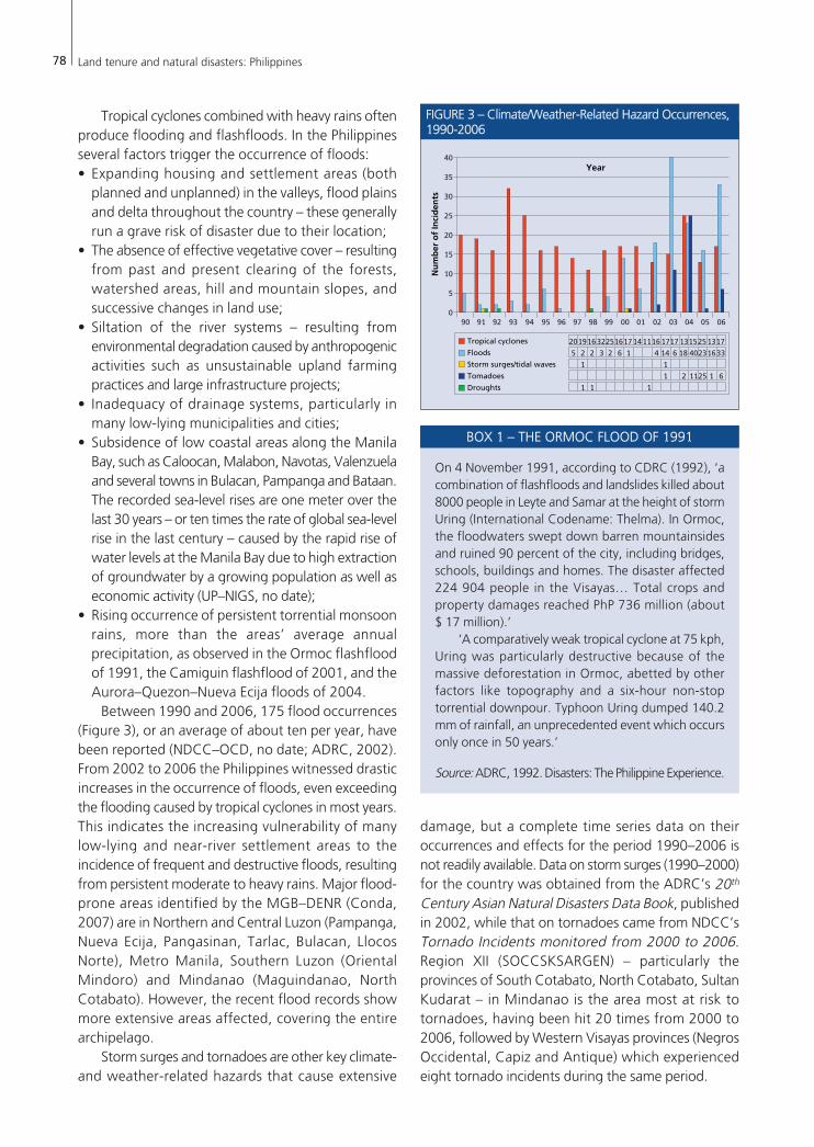
Landslides occur because of the geological instabilityof a hill or mountain slope when there is an earthquakeand/or heavy rain, as well as human activities such aslogging and mining. Most of the country’s provinces,except Palawan, are at risk of earthquake-inducedlandslides. From 1981 to 2006, the government
monitored 194 landslide incidents (Figure 2), or anaverage of eight incidents annually (OCD, no date). Theprovinces most at risk to landslides are Ifugao, Lanaodel Sur, Sarangani, Benguet, Mountain Province,Bukidnon, Aurora, Davao del Sur, Davao Oriental andRizal (Manila Observatory, 2005).
Perhaps unsurprisingly, provinces such as Sulu,Camiguin, Ifugao, Davao Oriental, Sarangani, Benguet,Surigao del Sur and Lanao del Sur, which rank highlyas regards their combined risk to the four majorgeophysical hazards (Manila Observatory, 2005), arealso the areas with a High Poverty Incidence Rating(NSCB and World Bank, 2005). Correlation betweenthe composite geophysical risk maps and land use mapsof these provinces, made by Manila Observatory, showsthat the very high risk areas are plantations anddipterocarp forests, which serve as a source of livelihoodfor local communities.
CLIMATE- AND WEATHER-RELATED HAZARDS
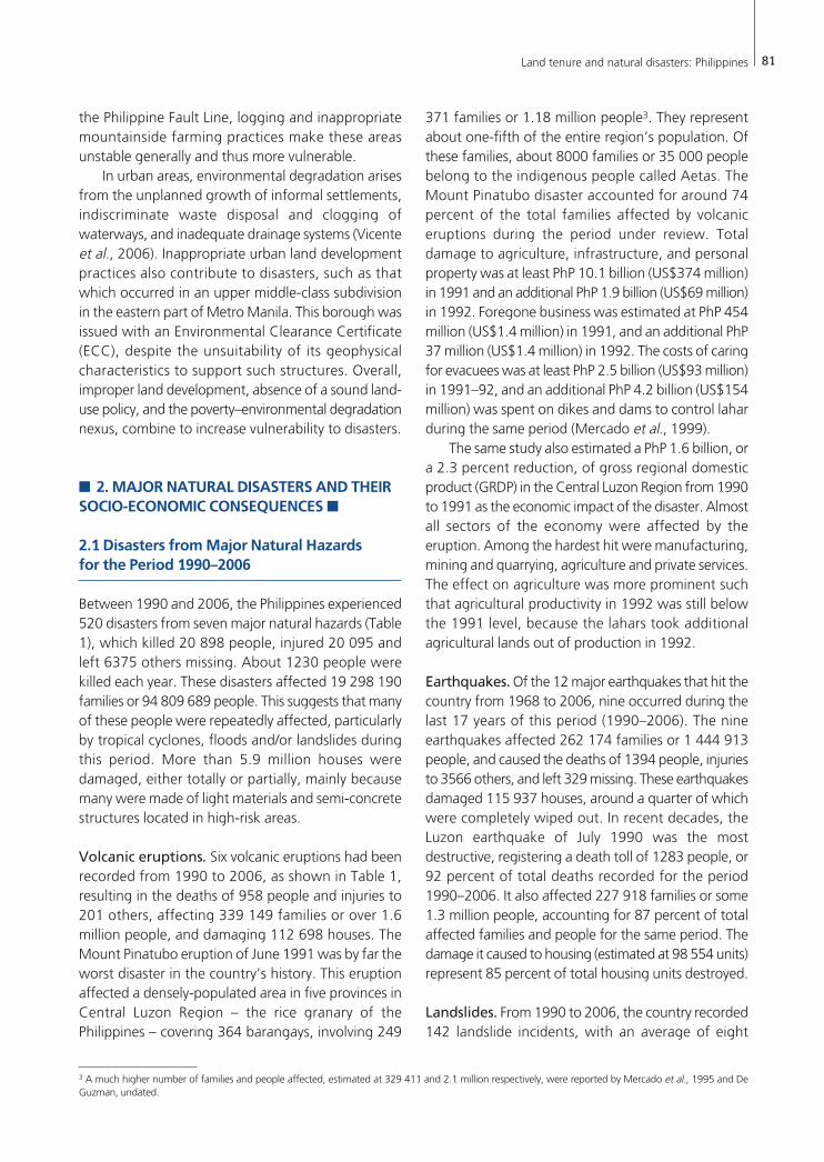
The majority of climate- and weather-related hazardsin the Philippines include tropical cyclones, floods,storm surges, tornadoes and droughts (Figure 3).Tropical cyclones (or typhoons, as they are commonlyknown in the Philippines) are regarded as the mostdestructive of all natural hazards in terms of a numberof factors: (i) the number of people affected (ii) thetotal value of the damage they cause (iii) their frequentoccurrence (iv) the size of the areas they affect, and(v) the high exposure and vulnerability of affectedcommunities and households. During the 17 yearsfrom 1990 to 2006, 303 tropical cyclones occurredin the Philippines’ area (Figure 3), amounting to anannual average of 18 cyclones (a little lower than the19–20 cyclones recorded from 1948 to 2006).However, the greatest number of cyclones took placein 1993, when the country recorded 32, of which sixwere considered ‘most destructive’ by the NationalDisaster Coordinating Council (NDCC).
Areas frequently and hard hit by tropical cyclonesare the Northern Luzon, South-eastern Luzon andEastern Visayas (Manila Observatory, 2005), whichface the Pacific Ocean. Tropical cyclones are lessfrequent in Western Visayas and Northern Mindanao,and rare in Southern Mindanao (CDRC, 1992). In thePhilippines, the typhoon season may start as early asApril or May and last until December or January, withmost of the destructive cyclones usually occurring inthe months of July, August and September. However,in recent years, destructive typhoons hit the countrymainly in the last quarter of the year.
Year
Nu
mb
er
of
Inci
de
nts
Number of Incidents
0
6 5 3 4 5 3 8 10 8 4 1 7 7 8 8 17 14 14 9 137 812 13
5
10
15
20
1981 82 83 84 85 868788 89 90 91 92 93 94 95 9697989900 01 02 03 04 05 06
FIGURE 2 – Landslide Incidents, 1981-2006
78 Land tenure and natural disasters: Philippines
Tropical cyclones combined with heavy rains oftenproduce flooding and flashfloods. In the Philippinesseveral factors trigger the occurrence of floods:• Expanding housing and settlement areas (both
planned and unplanned) in the valleys, flood plainsand delta throughout the country – these generallyrun a grave risk of disaster due to their location;
• The absence of effective vegetative cover – resultingfrom past and present clearing of the forests,watershed areas, hill and mountain slopes, andsuccessive changes in land use;
• Siltation of the river systems – resulting fromenvironmental degradation caused by anthropogenicactivities such as unsustainable upland farmingpractices and large infrastructure projects;
• Inadequacy of drainage systems, particularly inmany low-lying municipalities and cities;
• Subsidence of low coastal areas along the ManilaBay, such as Caloocan, Malabon, Navotas, Valenzuelaand several towns in Bulacan, Pampanga and Bataan.The recorded sea-level rises are one meter over thelast 30 years – or ten times the rate of global sea-levelrise in the last century – caused by the rapid rise ofwater levels at the Manila Bay due to high extractionof groundwater by a growing population as well aseconomic activity (UP–NIGS, no date);
• Rising occurrence of persistent torrential monsoonrains, more than the areas’ average annualprecipitation, as observed in the Ormoc flashfloodof 1991, the Camiguin flashflood of 2001, and theAurora–Quezon–Nueva Ecija floods of 2004.
Between 1990 and 2006, 175 flood occurrences(Figure 3), or an average of about ten per year, havebeen reported (NDCC–OCD, no date; ADRC, 2002).From 2002 to 2006 the Philippines witnessed drasticincreases in the occurrence of floods, even exceedingthe flooding caused by tropical cyclones in most years.This indicates the increasing vulnerability of manylow-lying and near-river settlement areas to theincidence of frequent and destructive floods, resultingfrom persistent moderate to heavy rains. Major flood-prone areas identified by the MGB–DENR (Conda,2007) are in Northern and Central Luzon (Pampanga,Nueva Ecija, Pangasinan, Tarlac, Bulacan, LlocosNorte), Metro Manila, Southern Luzon (OrientalMindoro) and Mindanao (Maguindanao, NorthCotabato). However, the recent flood records showmore extensive areas affected, covering the entirearchipelago.
Storm surges and tornadoes are other key climate-and weather-related hazards that cause extensive
damage, but a complete time series data on theiroccurrences and effects for the period 1990–2006 isnot readily available. Data on storm surges (1990–2000)for the country was obtained from the ADRC’s 20th
Century Asian Natural Disasters Data Book, publishedin 2002, while that on tornadoes came from NDCC’sTornado Incidents monitored from 2000 to 2006.Region XII (SOCCSKSARGEN) – particularly theprovinces of South Cotabato, North Cotabato, SultanKudarat – in Mindanao is the area most at risk totornadoes, having been hit 20 times from 2000 to2006, followed by Western Visayas provinces (NegrosOccidental, Capiz and Antique) which experiencedeight tornado incidents during the same period.
On 4 November 1991, according to CDRC (1992), ‘acombination of flashfloods and landslides killed about8000 people in Leyte and Samar at the height of stormUring (International Codename: Thelma). In Ormoc,the floodwaters swept down barren mountainsidesand ruined 90 percent of the city, including bridges,schools, buildings and homes. The disaster affected224 904 people in the Visayas… Total crops andproperty damages reached PhP 736 million (about $ 17 million).’
‘A comparatively weak tropical cyclone at 75 kph,Uring was particularly destructive because of themassive deforestation in Ormoc, abetted by otherfactors like topography and a six-hour non-stoptorrential downpour. Typhoon Uring dumped 140.2mm of rainfall, an unprecedented event which occursonly once in 50 years.’
Source: ADRC, 1992. Disasters: The Philippine Experience.
Year
Nu
mb
er
of
Inci
de
nts
Tropical cyclones 20191632251617141116 1717 131525 1713Floods
Storm surges/tidal waves
Tomadoes
Droughts
5 2 2 3 2 6 1 4 14 6 18 4023 3316
1 1
1 2 1125 61
1 1 1
090 91 92 93 94 95 96 97 98 99 00 01 02 03 04 05 06
5
10
15
20
25
30
35
40
FIGURE 3 – Climate/Weather-Related Hazard Occurrences,1990-2006
BOX 1 – THE ORMOC FLOOD OF 1991

Land tenure and natural disasters: Philippines 79
If tropical cyclones and floods are more frequentin the Philippines, so in more recent years are droughts,although complete information on this latter hazardis not readily available. Many scientists and researchershave increasingly linked the occurrence of droughtsto climate change issues (Greenpeace, 2007; Jose andCruz, 1999), indicating their effects to be morewidespread and devastating, particularly to agriculturewhich supports the primary livelihoods of two-thirdsof Filipinos living in rural areas. Based on the threedrought incidents reflected in Figure 3, the areas mostat risk to extreme dryness or temperature increase areprovinces in Central and Western Visayas andMindanao, which support the study conducted byManila Observatory (2005).
When the combined risk to four climate- andweather-related hazards (tropical cyclones, El Niño-induced droughts, projected temperature increasesand rainfall changes) in the country was mapped outby Manila Observatory (2005), the areas most at riskto simultaneous incidence of such hazards areSoutheastern Luzon and Eastern Visayas. TheObservatory explained ‘that the risk to typhoons andrisk to projected rainfall change dominate the sum’;this confirms the substantial amount of rain dumpedon the country, almost all year round, by large-scaleatmospheric phenomena. However, the uneven
distribution of rain over time and space varies theseverity of the impact of disasters across provinces andregions. Half of the top 20 provinces (Albay, Sorsogon,Sulu, Ifugao, Northern Samar, Masbate, Biliran,Western Samar, Basilan, Camarines Sur) that run ahigher risk to all climate- and weather-related hazards(Manila Observatory, 2005) also have a High PovertyIncidence Rating (NSCB and World Bank, 2005).
POVERTY AND VULNERABILITY
The greater vulnerability to natural hazards ofprovinces and regions with high poverty incidenceemphasizes the importance of understanding the linksbetween poverty and the country’s vulnerabilitybeyond its geophysical characteristics. These linkagesare illustrated in a recent study conducted by the WorldBank and NDCC (no date: 13):
‘‘Poverty and vulnerability to natural hazardsare closely linked and mutually reinforcing. Poorand socially disadvantaged groups are usually themost vulnerable to hazards, reflecting their social,cultural, economic and political environments …Indeed, at the household level, poverty is the singlemost important factor determining vulnerability,in part reflecting location of housing (e.g. onfloodplains, riverbanks, steep slopes …); level ofaccess to basic services (e.g. refuse collection)
©FA
O/P. Johonson

80 Land tenure and natural disasters: Philippines
particularly for illegal squatters; sources oflivelihood; and level of access to financial and otherassets and resources, leaving limited recourse tointer-temporal consumption smoothing.’
In that same study, the country’s poverty incidenceis reported at 26 percent in 2000, which remains a majorchallenge to national development. The study furtherdescribes poverty as highly concentrated in rural areas,where about 77 percent of the poor reside; two-thirdsof these people rely on the agriculture, fishing andforestry sectors for their livelihoods. Absence or lack ofland tenure is a central issue among the poor, forcingmany to live and work in high-risk areas (World Bankand NDCC, no date), such as in the danger zones of thesix most active volcanoes and practically all deforestedmountains, riverbeds, low-lying flood plains and coastalareas in the country. While most of the poor are nowaware of the risk and vulnerability of these areas tonatural hazards, they have no other choice but to acceptor ignore such realities, in order to be closer to theirsources of livelihood. These areas attract the poor, whooften have no assets in the more developed lowlandareas for constructing houses and developing livelihoods.As a result, informal settlements including resettlementsites have gradually expanded in high-risk areas in recentyears. Even the remaining natural barriers such aspatches of forested slopes and mangroves have notbeen spared from this informal settlement expansion.
Poverty compels people to build houses from lightscrap materials or locally-collected bamboos and palmleaves that are unable to withstand the impact of tropicalcyclones, floods, landslides and storm surges. Repair orreconstruction of houses becomes a frequent activityof the poor after every disaster. Lack of secure tenurealso reduces incentives for people to invest in housingimprovements and in permanent agricultural productionsystems, or to modify their micro-environment to protecttheir farms and fishing grounds against floods, landslides,droughts, etc. This desolate condition weakens thecapacity of the poor to prepare for disasters, or adaptto changes and recover after such events. Consequently,as the World Bank and NDCC (no date) reports, 24 ofthe 30 families who suffered from the 1991 Ormoc floodreturned to their original areas because they hadnowhere else to live, although they recognized the
dangers of living on the riverside. In other cases, familiesreturned to their original areas even when resettlementsites were made available to them, due to the proximityof these to their place of work and other means oflivelihood2. Surprisingly, neither the affected familiesnor the support organizations have given attention toland tenure issues following disasters.
In major cities, urban poverty is manifested by theuncontrolled expansion of informal settlements on publicland and hazard-prone areas. The vulnerability todisasters of informal settlements in key urban areas ismagnified by the following: (i) a lack of land tenure orlegal ownership of the land (ii) structures are usuallymade of scrap and lightweight materials (iii) a lack of alogical spatial pattern of settlement, due to the absenceof land development plans; hence there is no provisionfor safety structures such as alleys, roads, easements (iv)the majority are located in easements such as alongrivers, creeks or drainage systems and/or danger zonessuch as under bridges, beside railroad tracks, and insidegarbage dumpsites (Vicente et al., 2006). In the area ofQuezon City, for example, a tragedy occurred in thebiggest dumpsite in Metro Manila called the Payatasarea, when a huge mountain of decaying garbagecollapsed in July 2000 burying 224 people, injuring 36and leaving 16 missing. This damaged 103 houses andaffected 135 families, or 680 people.
ECOLOGICAL DEGRADATION
In addition to adverse socio–economic conditions thatlead people to inhabit high-risk areas, many people alsoengage in unsustainable and dangerous livelihoods. Inthe Payatas landslide, for instance, affected familieshad been engaged in scavenging and recovery ofrecyclable materials, despite awareness of the dangersthey would be exposed to in this enterprise. The tragic1991 landslide in Ormoc City, Leyte Province, and the2004 devastating landslides and flashfloods in Auroraand Quezon Provinces, had been partly attributed tologging (legal or illegal) and other wood-basedindustries. In the latter provinces, these activities haveserved as the main sources of people’s livelihoods,reducing forest cover to only 20 percent in QuezonProvince and 70 percent in Aurora Province (CDRC,2004). As the areas affected by landslides lie along
2 For example, an interview with two of the more than 220 affected families after the 2006 Typhoon Reming flood and mudflow (in Barangay Padang withinLegaspi City, Albay), found that they returned to their former areas because they could readily find sources of livelihood, such as selling ready-to-eat food andfishing on nearby municipal waters. These sources were not available in the resettlement site located in an upland section of Barangay Taysan. The families alsocited the proximity to market, the transport network and the stable supply of potable water in their areas, as compared with the resettlement site, as factorsinvolved in their decision to stay.
Land tenure and natural disasters: Philippines 81
the Philippine Fault Line, logging and inappropriatemountainside farming practices make these areasunstable generally and thus more vulnerable.
In urban areas, environmental degradation arisesfrom the unplanned growth of informal settlements,indiscriminate waste disposal and clogging ofwaterways, and inadequate drainage systems (Vicenteet al., 2006). Inappropriate urban land developmentpractices also contribute to disasters, such as thatwhich occurred in an upper middle-class subdivisionin the eastern part of Metro Manila. This borough wasissued with an Environmental Clearance Certificate(ECC), despite the unsuitability of its geophysicalcharacteristics to support such structures. Overall,improper land development, absence of a sound land-use policy, and the poverty–environmental degradationnexus, combine to increase vulnerability to disasters.
� 2. MAJOR NATURAL DISASTERS AND THEIRSOCIO-ECONOMIC CONSEQUENCES �
2.1 Disasters from Major Natural Hazards for the Period 1990–2006
Between 1990 and 2006, the Philippines experienced520 disasters from seven major natural hazards (Table1), which killed 20 898 people, injured 20 095 andleft 6375 others missing. About 1230 people werekilled each year. These disasters affected 19 298 190families or 94 809 689 people. This suggests that manyof these people were repeatedly affected, particularlyby tropical cyclones, floods and/or landslides duringthis period. More than 5.9 million houses weredamaged, either totally or partially, mainly becausemany were made of light materials and semi-concretestructures located in high-risk areas.
Volcanic eruptions. Six volcanic eruptions had beenrecorded from 1990 to 2006, as shown in Table 1,resulting in the deaths of 958 people and injuries to201 others, affecting 339 149 families or over 1.6million people, and damaging 112 698 houses. TheMount Pinatubo eruption of June 1991 was by far theworst disaster in the country’s history. This eruptionaffected a densely-populated area in five provinces inCentral Luzon Region – the rice granary of thePhilippines – covering 364 barangays, involving 249
371 families or 1.18 million people3. They representabout one-fifth of the entire region’s population. Ofthese families, about 8000 families or 35 000 peoplebelong to the indigenous people called Aetas. TheMount Pinatubo disaster accounted for around 74percent of the total families affected by volcaniceruptions during the period under review. Totaldamage to agriculture, infrastructure, and personalproperty was at least PhP 10.1 billion (US$374 million)in 1991 and an additional PhP 1.9 billion (US$69 million)in 1992. Foregone business was estimated at PhP 454million (US$1.4 million) in 1991, and an additional PhP37 million (US$1.4 million) in 1992. The costs of caringfor evacuees was at least PhP 2.5 billion (US$93 million)in 1991–92, and an additional PhP 4.2 billion (US$154million) was spent on dikes and dams to control laharduring the same period (Mercado et al., 1999).
The same study also estimated a PhP 1.6 billion, ora 2.3 percent reduction, of gross regional domesticproduct (GRDP) in the Central Luzon Region from 1990to 1991 as the economic impact of the disaster. Almostall sectors of the economy were affected by theeruption. Among the hardest hit were manufacturing,mining and quarrying, agriculture and private services.The effect on agriculture was more prominent suchthat agricultural productivity in 1992 was still belowthe 1991 level, because the lahars took additionalagricultural lands out of production in 1992.
Earthquakes. Of the 12 major earthquakes that hit thecountry from 1968 to 2006, nine occurred during thelast 17 years of this period (1990–2006). The nineearthquakes affected 262 174 families or 1 444 913people, and caused the deaths of 1394 people, injuriesto 3566 others, and left 329 missing. These earthquakesdamaged 115 937 houses, around a quarter of whichwere completely wiped out. In recent decades, theLuzon earthquake of July 1990 was the mostdestructive, registering a death toll of 1283 people, or92 percent of total deaths recorded for the period1990–2006. It also affected 227 918 families or some1.3 million people, accounting for 87 percent of totalaffected families and people for the same period. Thedamage it caused to housing (estimated at 98 554 units)represent 85 percent of total housing units destroyed.
Landslides. From 1990 to 2006, the country recorded142 landslide incidents, with an average of eight
3 A much higher number of families and people affected, estimated at 329 411 and 2.1 million respectively, were reported by Mercado et al., 1995 and DeGuzman, undated.
82 Land tenure and natural disasters: Philippines
incidents annually. The frequency of the landslides,however, increased if compared with six for theprevious decade (1981–1990). The Guinsaugonlandslide of December 2003 in St Bernard, SouthernLeyte, was one of the most disastrous events, killing154 people, displacing and disrupting the lives of 3811families, and incurring about PhP 115.0 million ofdamage to agriculture and infrastructure.
Tropical cyclones. These are the single mostimportant cause of disasters in the Philippines. About46 percent of the 303 cyclones that hit the countryduring the last 17 years turned destructive, with atleast eight occurring annually. Two of these eightdestructive cyclones per year were considered ‘mostdestructive’, causing the highest number of casualties,affecting families and damaging houses, and incurringthe highest cost of damages. Between 1990 and 2006,the 139 cyclones have killed about 16 800 people(including missing people), of which about 6400 diedduring Typhoon Uring, which submerged the entireOrmoc City in Leyte Province. For the same period,cyclones killed about 990 people and incurred overPhP 8.0 billion of total damages each year.
Floods. The combined confluence of geological andclimate factors has caused more flooding incidentsthan any other hazard that hit the country in the period1990–2006. There were 175 flooding incidents, whichkilled 5523 people, affected about 1.1 million familiesor over 5.2 million people, damaged 45 062 houses,and caused financial losses amounting to around PhP6.08 million. The misplacement of human settlements,including livelihood sources, in high-risk areas hasclearly contributed to the environmental degradationthat enhances the occurrence of flood, even in theabsence of tropical cyclones. The available limited
studies (World Bank and NDCC, no date; Vicente etal., 2006) tend to support this observation.
Storm surges. These are another hazard facing thePhilippines, but little information on storm surges isavailable. ADRC (2002) recorded two occurrences ofstorm surges in 1991 and 2000, which killed 10 peoplein Samar and Leyte Islands and left 5250 othershomeless. No estimates on economic damages werereported.
Tornados. Forty six tornadoes struck the Philippinesduring the period 1990–2006, which claimed the livesof 14 people, injured 72 and left 54 others missing.Overall, these incidents affected 7227 families or 38950 people, the majority living in the provinces ofNorth and South Cotabato, Sultan Kudarat,Maguindanao, Sulu and Zamboanga Sibugay inMindanao, and Negros Occidental, Leyte, SouthernLeyte, and Cebu in the Visayas. In Luzon, althoughthese events were not so significant, tornados alsocaused human and property impacts in the provincesof Zambales, Tarlac, Nueva Ecija and Bulacan. Totaltornado damages have been estimated at around PhP128.62 million.
Droughts. The El Niño induced drought has recentlycaused damage on a wider scale in the Philippines.Although there were only three drought incidentsduring the period 1990–2006, the 1998 droughtproduced the most extensive damage to the country’seconomy. Apart from causing severe water supplyproblems throughout the country (covering all 16regions), it also paralysed agricultural production inover 368 469 hectares, with an estimated value of PhP20.6 billion. Extreme dryness also brought aboutseveral forest fires in 41 barangays within 17 cities and
TABLE 1 – Major Natural Disaster Impacts in the Philippines, 1990–2006
DISASTER TYPE FREQ CASUALTIES POPULATION AFFECTED HOUSES DAMAGED
DEAD INJURED MISSING FAMILIES PEOPLE TOTALLY PARTIALLY
Volcanic eruption 6 958 201 23 339 149 1 619 029 44 247 68 451
Earthquake 9 1394 3,566 329 262 174 1 444 913 27 276 88 661
Landslides 142 735 387 81 15 422 75 147 719 1574
Tropical cyclones 139 12 274 15 184 4524 15 422 872 76 638 345 1 430 039 4 224 617
Floods 175 5523 685 1364 1 107 405 5 253 367 9234 35 828
Tornado 46 14 72 54 7227 38 950 652 1364
Drought and the El Niño phenomenon 3 0 0 0 2,143,941 9 739 938 0 0
Total 520 20 898 20 095 6375 19 298 190 94 809 689 1 512 167 4 420 495
Source: Data obtained from National Disaster Coordinating Council, Office of Civil Defense.

Land tenure and natural disasters: Philippines 83
municipalities in eight provinces, covering 5482hectares, with damages valued at PhP 42.8 million.This drought also inflicted damage on variousindustries because of the reduced capacity for powergeneration and increased scarcity of water supplies,resulting in partial operations and the dismissal ofworkers.
2.2 Economic Impacts of Major NaturalDisasters
In the Philippines, economic impacts of natural disastershave been measured in terms of direct losses toagriculture, public infrastructure and private property.Between 1990 and 2006, the average annual directdamage to the country as a consequence of the majornatural disasters reviewed in the previous section, hasbeen estimated at around PhP 9.2 billion (in current prices;Table 2). This direct damage was equivalent to an averageof 0.2 percent of the country’s Gross Domestic Product(GDP) every year, a marked difference from an earlierstudy (calculated at 0.7 percent) prepared by World Bankand NDCC (no date) based on data over a longer time
span (1970–2000). However, the problem of datainconsistencies4 as regards annual damages by disastertype could partly account for the difference in theestimated average percentage of annual direct damageto GDP. Tropical cyclones and earthquakes caused themost damage to the country over the period 1990–2007,with cyclones alone accounting for about 87 percent oftotal damage, reflecting their high annual frequency(World Bank and NDCC, no date). Earthquakes accountedfor about 9 percent of total damage. These two extremeevents also caused over 65 percent of total deathsrecorded during the same period.
Flooding, which accounted for the second highestdeath toll and human impact after tropical cyclones,amounted to an additional 4 percent of total damages.This hazard has shown an increasing occurrence inrecent years, reflecting the continuing growth anddensification of populations and human settlements,as well as the intensification of agricultural activitiesin high-risk areas. Other natural disasters (tornados,landslides and volcanic eruptions) accounted for only0.15 percent of total damages, partly reflecting thelocalized nature of their impacts.
4 Some tabulated data on different natural disasters obtained from NDCC contain certain discrepancies – even for a similar time period – as regards disasteroccurrences, human and housing impacts, and economic damages. This might be explained by the periodic updating undertaken by NDCC, in which the specificdates of data updating or revision are not indicated or reflected.
©FA
O/M
aimone

84 Land tenure and natural disasters: Philippines
The agriculture, fisheries and forestry sectorssuffered the biggest losses from disasters, averagingPhP 5.5 billion or about 60 percent of total damageper year over the period 1990–2006. These losses wereequivalent to an annual average of at least 0.7 percentof GDP originating from this sector. Public infrastructurelosses amounted to PhP 3.1 billion or 34 percent oftotal damage per year, which included damages toagricultural support systems such as dams, andirrigation and drainage facilities. Losses to privateproperty accounted for about PhP 0.6 billion, or 6percent of total damage per year. The relatively lowvalue of private property losses partly reflects thequalities of the housing and other structures ownedor in the possession of affected households.
2.3 Consequences on Agricultural Productionand Livelihoods
Agriculture, including fisheries and forestry, plays amajor role in the Philippines’ economy for two main
reasons: (i) two-thirds of the total population dependon farming for their livelihood, and about half of thetotal labour force is employed or engaged inagricultural activities (ii) some 13.0 million hectares or43 percent of the country’s total land area is devotedto agricultural crops (Jose et al., no date). In morerecent years (2003–2006), the agriculture sectorcontributed an average of 15 percent to GDP per year,and registered 3.85 percent growth in 2006 (DA,2007). The output gains throughout the years,however, have not significantly benefited andimproved the lives of farmers, particularly smalllandowners, landless tenants and farm workers. Thiscould be attributed to the existing farm structure inthe country, where a majority of the farms are small(averaging about 2.0 hectares), and about 21 percentof the agricultural farms covering some 8.0 millionhectares have yet to be titled, according to the 2002Census of Agriculture (DA, 2007). Many poor farmerswith small farm areas lack the capital to invest inimproved production technologies and more drought-
TABLE 2 – Estimated Total Damage from Natural Disasters (at Current Prices), 1990–20065
YEAR GEOPHYSICAL DISASTERS CLIMATE/WEATHER RELATED DISASTERS TOTAL
VOLCANIC EARTHQUAKE LANDSLIDES TROPICAL FLOODS TORNADOERUPTION CYCLONES
Estimated Damage (Millions of Pesos)
1990 12 380.04 11 176.00 62.00 23 618.04
1991 3516.00 1044.81 4560.81
1992 5183.00 5183.00
1993 0.01 20 076.00 20 076.01
1994 513.02 3200.00 3713.02
1995 16 255.00 720.00 16 975
1996 0.01 699.00 699.01
1997 1010.00 1,010.00
1998 17 017.00 17 017.00
1999 333.19 0.03 2578.00 2991.22
2000 10.79 7470.00 841.38 15.00 8337.17
2001 6968.00 402.27 7370.27
2002 132.99 829.00 912.84 3.29 1878.12
2003 40.66 41.69 4171.00 449.89 3.38 4706.62
2004 25.72 13 262.46 212.84 97.01 13 598.03
2005 10.32 2552.66 317.46 2880.44
2006 10.12 20 227.03 1224.05 9.94 21 471.14
1990–2006 2.80 2235.10 12.60 8001.20 618.75 25.70 9181.45
averagepercentage share by disaster type 0.01 8.60 0.06 87.25 4.00 0.08 100
Source: Data obtained from National Disaster Coordinating Council, Office of Civil Defens.
5 Available data on volcanic eruption obtained from OCD-NDCC has only reflected the total number of events from 1991 to 2006, and the corresponding totaldamages broken down into the following sectors: agriculture, infrastructure, private property.

Land tenure and natural disasters: Philippines 85
resistant crop varieties. Unlike rich landowners withlarge farms, poor farmers are unable to undertakerisk-reducing measures, such as contour farming, treeplanting along paddy field borders in hilly areas, andthe construction of protective dikes.
Past records show that ‘Dramatic increases ordecreases in agricultural output have been, in most cases,associated with the occurrence of severe weather eventsand changes in the climate system’ (Jose et al., no date).Between 1991 and 2000, World Bank and NDCC (nodate) found that annual ‘rice crop losses equivalent to2.6 percent of actual production (in volume terms) wereexperienced as a consequence of typhoons and flooding’.Drought caused an annual loss of another 1.5 percentof the actual rice production for the same period. Theworst impact of the combined typhoons, floods anddrought on agriculture was experienced in 1998 withthe highest agricultural losses recorded at about 18percent of actual rice production (in volume terms).During this year, poverty incidence in the country soaredto 28 percent, following a gradual improvement of thismeasure from a high of 34 percent in 1990 to 25 percentin 1997. As a consequence, agricultural output in 1998shrunk to about 8.6 million tons, or 24 percent lowerthan that produced in 1997. Agricultural employmentalso dropped to about 10.1 million people or 11 percent
lower than in the previous year (DA, no date). Freeman,Keen and Mani (2003) estimated that ‘about 50 percentof the increase in headcount poverty in the Philippinesduring the 1998 crisis has been attributed to El Niño’.This 1998 crisis demonstrated how the living conditionsof the rural poor in general, and the farmers in particular,could easily worsen in the face of natural disasters. Suchdisasters not only destroy their houses and otherproperties, but also severely impact their primary sourcesof livelihood by destroying crops, killing livestock, etc,resulting in reduced production and income. In extremeevents, such as the 1991 Mount Pinatubo eruption, the2006 Guinsaugon landslide and the 2006 TyphoonReming, the impact had been a permanent loss ofcultivated farmlands for thousands of farmers.
2.4 Consequences on Land Tenure and Property of Affected Households
In the Philippines, there has been no study to examinethe direct impacts of natural disasters on land tenureand property. Existing literature only refers to landtenure in relation to poverty in the context of thepoverty–disaster nexus (World Bank and NDCC, nodate; Vicente et al., 2006). This section therefore drawson the views of government and non-government
©FA
O/J. V
illamora

86 Land tenure and natural disasters: Philippines
officers who have been involved in disaster relief andmitigation activities, and the experiences of somedisaster–affected people from the Province of Albayin Bicol Region.
Disasters cause undue displacement of affectedhouseholds, thereby resulting in either temporary orpermanent changes in land tenure and property. Theseverity of impact differs in terms of: (i) whether theaffected people have secure or insecure tenure on theirproperty (ii) whether the disaster caused lasting damageon the property (iii) the capacity of the affected peopleto recover their lost property, or to restore and improvetheir tenure security, which is mainly defined by theirsocio-economic status.
People with secure tenure are more confident aboutreclaiming their property if the damage is not permanent.In the case of households that were affected by mudflowsfrom Mount Mayon resulting from Typhoon Reming inAlbay, those with titles returned immediately to theirproperties, given their awareness that the title recordskept at the Register of Deeds would confirm legally thelocation of their boundaries. Moreover, because houseson titled properties are often built of strongerconstruction materials, finding the exact locations ofthe properties is not so difficult, because of the highlikelihood that parts of the structures may still be intactafter the disaster. This was the case for many residentialproperty owners affected by the Mount Pinatuboeruption. In circumstances where the landmarks couldnot be easily reestablished after the eruption, ownershave sought the services of geodetic engineers to relocatetheir boundary markers, based on the approved surveyplans (Gerochi, personal communication, 2007).
In contrast, those affected households with no securetenure are likely to have greater difficulty in relocatingor reclaiming their original occupied properties followinga disaster. This is more pronounced in the case offarmlands, especially when trying to locate the originalposition of farm dwellings. In the absence of boundarymarks and permanent structures, returning to theproperty is made easier by community recognition ofeach others’ rights to occupancy, because neighbourshelp each other in reestablishing the original boundariesof their formerly-occupied properties, based on trust.This sense of cooperation is strong among affectedcommunity members immediately after a disaster, sincethey share a common experience and a willingness tohelp each other in coping with its after effects. However,the possibility of boundary disputes may arise once theparcel boundaries are delineated once more via surveys(Oyardo, personal communication, 2007).
Where the damage to land is permanent, affectedpeople, regardless of their tenure, often find themselveseased out of their original communities and relocated ingovernment-designated resettlement sites. This isparticularly true for informal settlers, who have no choicebut to accept moving to the resettlement sites so as toestablish new dwellings and engage in other livelihoodactivities. However, in many cases, the relocation sitesdo not provide better alternatives to their former way oflife. For instance, affected families in Aurora, Quezon,after the 2004 landslides that were triggered by fourconsecutive typhoons, were advised that their originalcommunity was no longer suitable for habitation becauseof the dangers it posed to people and property.Nevertheless, affected people thought that the relocationsite was too far away from their original area, and wouldforce them to alter their source of livelihood from fishingto farming (Gerochi, personal communication, 2007). Inthe same vein, the affected families in Barangay Padang,Legazpi city, found themselves landless after TyphoonReming hit Albay in November 2006; houses weredamaged and farms were covered by rocks andmudflows unloaded by flashfloods from the gullies ofMount Mayon, making the farms unsuitable foragriculture (Echaluci, personal communication, 2007).However, many families still chose to stay in the area:the large boulders that piled up in settlement areas andfarmlands meant that quarrying emerged as a newindustrial activity, although the types of equipment foundoperating in the area suggest that the operator was notamong the affected people. In another affectedbarangay, in Guinobatan, Albay, former farmers foundthemselves employed as labourers in quarryingcompanies. Work in this sand and gravel mining wasmade possible by the ease of accessibility to the quarries– located in the former barangay – from the newMabugos Resettlement Site, given that the a distancebetween them is only about one kilometre. For somefarmers who accepted resettlement on the new site,renting farmland has been another option, allowing themto continue their agricultural production activities andeke out a living (Oyardo, personal communication, 2007).
The situation is different for the Aeta people – ahunting and gathering indigenous group hit by theMount Pinatubo eruption. Documented case studies(Seitz, 2004) reveal that the disaster affected the Aetapeople in three ways: (i) some faced up to theinevitability of life in the lowlands (ii) others abandonedthe resettlement site and went back to their originalhabitats (iii) others opted to stay in offsite settlementswhich the Aetas have established. In each of these
Land tenure and natural disasters: Philippines 87
scenarios, the effect is loss of their ancestral domain,and forced adaptation to new ways of life. In the firstscenario, they became significantly exposed toChristian Filipinos, and ended up as labourers largelydependent on the government and NGOs for support,eventually losing their jobs and the prospect ofalternative employment. As a result, many familiesreturned to the hinterlands of San Marcelino,Zambales. In the second scenario, those who initiallystayed in the resettlement sites and went back to theiroriginal habitats have imbibed permanent agriculture,such as planting wet rice – a lowland farming practice– instead of growing tubers which had been theirtradition. In the third scenario, some adapted a morepermanent mode of settlement but separatedthemselves from the lowland population, which helpedto preserve their traditional culture and practices.
2.5 Difficulties in dealing with the Consequences of Disaster Damages on Land Tenure and Property
The main difficulty in dealing with the consequencesof disasters on land tenure and property liesfundamentally in the lack of awareness of theimportance of land tenure and property in a disastercontext. It is very apparent from the documentationreviews and interviews conducted for this task thatthere is no clear recognition so far of the extent towhich land tenure issues come into play in disasterprevention, emergency relief work and rehabilitation.Thus, there is no systematic way of gatheringinformation on the effects of disasters on the landtenure and property rights of affected families. As aresult, these concerns do not feature in the currentdisaster prevention programmes, emergency workprogrammes, and rehabilitation programmes ofgovernments and other organizations.
However, the field observations, interviews anddocumentation reviews undertaken have highlighteda number of administrative and legal constraints inthe existing land administration system that will makeit difficult for governments and other organizationsto address these issues. These constraints are asfollows6:
Absence of a complete cadastre. The land offices(DENR–LMB, RoD, LGU’s Assessor Office) do not have
complete records of all rights to land. The presence ofmany agencies involved in land titling and landadministration has led to the duplication of and overlapsin records, in some cases resulting in issuance of doubletitles over the same property. There is no comprehensiveset of maps that supports the title records issued, therebyincreasing the probability of overlapping titles. In thecontext of rehabilitation after a disaster, this situationaggravates the probability of issuing multiple titles onthe same property.
Absence of a programme for the maintenance ofcontrol points. Many of the control points installedin the past decades throughout the country have beendamaged or destroyed, for a variety of reasons. The
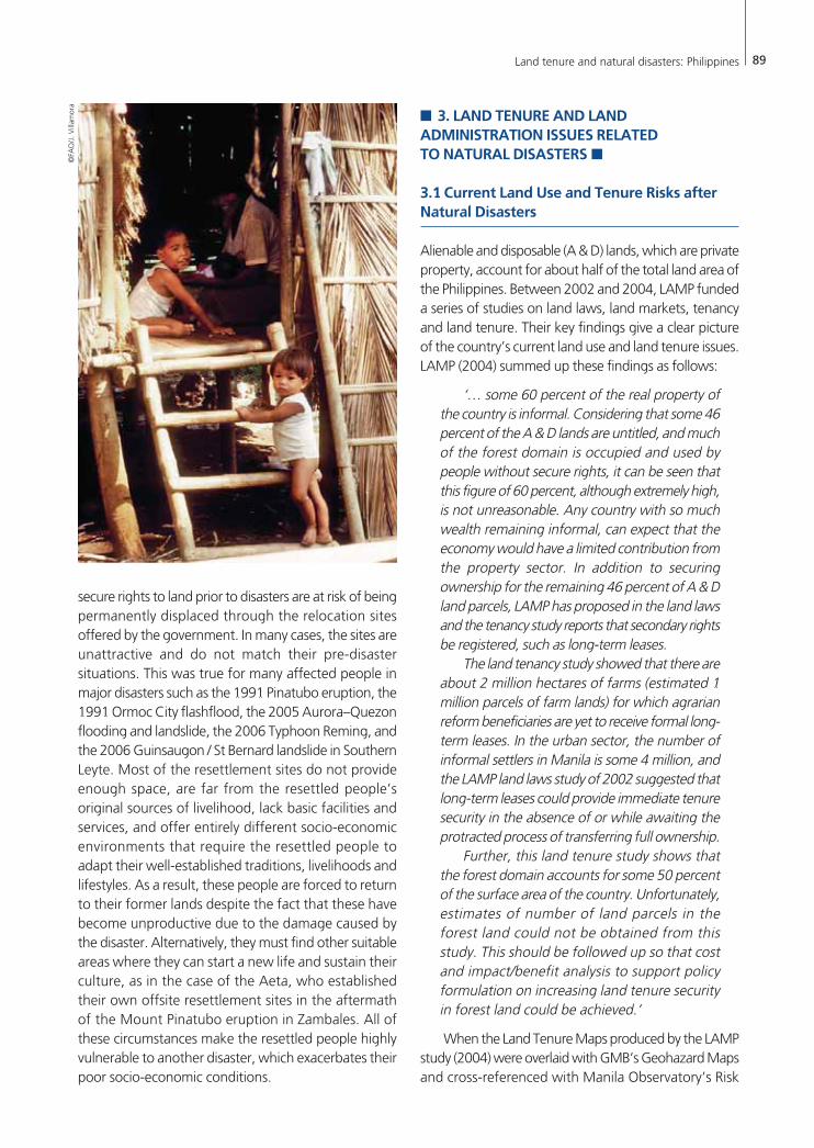
Land survey records damaged by Typhoon Reming
in Albay in November 2006, consisting of:
• Cadastral maps for surveys for the whole
province.
• List of survey claimants for surveys, and
• Technical descriptions of surveys.
Source: DENR PENRO/CENRO, Legaspi City, Albay.
6 Many of these issues were based on the reports and experiences of the Land Administration and Management Project Phase 2 (LAMP2) in the Philippines,funded by the World Bank and AusAID.

88 Land tenure and natural disasters: Philippines
government does not have an active monitoring andmaintenance programme to reestablish the controlpoints. In the case of the Mount Pinatubo eruption,for instance, the National Mapping and ResourceInformation Authority (NAMRIA) has not beensuccessful in gaining the funds necessary to reestablishprimary control points; these are required to guidesubsequent cadastral surveys for relocating the parcelboundaries of property owners.
Many of the land records have been lost, damagedor destroyed. Most DENR field offices have incompleteand outdated land records; these have been lostbecause of frequent transfers and theft, and damagecaused by fire, floods and vermin infestation. The DENRprovincial office in Albay, for instance, lost 2445cadastral maps and other land survey records whenthe roof of its office building collapsed during TyphoonReming. Reconstitution of records is difficult and costly,as the DENR does not maintain a systematic filing systemfor such records. It will need to rely on the file copiesof the DENR Regional Office and surveyors to reconstructthe lost or damaged records. This situation is true inmany parts of the Philippines. In order to resume theprocessing of applications for original title, landclaimants will have to reconstitute their documents incases where they were damaged or lost at the DENR.For many affected families who have lost their homesand properties, however, this will take time, as thedocuments will have to be reconstructed and/or securedagain from other government offices. An additionalcomplication is the fact that other land-related offices,such as the RoD in Albay, also experienced damages toan undetermined number of title records due to theflash floods caused by Typhoon Reming. In this case,the owners would have to file for reconstitution of theoriginal file copy at the RoD.
Costly and lengthy process of title reconstitution.This is a legal process whereby the owner files apetition in court to reconstitute the title records thatwere lost or damaged at the RoD. The owner shouldersall the related costs, including legal fees, which areestimated to be about PhP 20 000 (Villanosa, personalcommunication, 2007). The process could take monthsto complete, given that that the RoD does not have acomplete cadastre. Experience from the World Bankand AusAID funded Land Administration andManagement Project (LAMP) reveals that one of thecauses of double titling is judicial reconstitution,whereby the court issues new title copies for records
which have been lost or destroyed. A surge inapplications for title reconstitution is noted in areasfollowing a disaster (Cledera and Suarez, personalcommunications, 2007).
Costly and lengthy process of securing title copies.Property owners who have lost their copies of titles willhave to secure a second owner’s copy at the RoD. Thisis also a purely legal process whereby the owner petitionsthe court to grant the RoD an authority to issue a secondowner’s copy. This process is initiated by the owner, andexpenses incurred are again shouldered by the owner.Once more the process could take months to complete,and may cost the owner about PhP 10 000 (Villanosa,personal communication, 2007). An increase inapplications for a second owner’s copy is also noted inareas following a disaster (Cledera and Suarez, personalcommunications, 2007).
Costly process of relocating parcel boundary marks.This process is undertaken and paid for at the initiativeof the property owner. The Geodetic Engineers of thePhilippines (GEP) has set standards for this service, whichwould cost the property owner an average of PhP 10000 to 12 000. The government does not have aprogramme to support affected families in relocatingtheir parcel boundaries following disasters.
Presence of many erroneous surveys. The relocationof boundary marks is made more complex by thepresence of many erroneous surveys. The experience ofLAMP was that an additional process had to beintroduced – called survey validation – to determinewhether the quality of survey works warranted theissuance of titles. This has been necessary due to poorsurvey practices, and a lack of monitoring and supervisionof survey works. The end result is the increasedprobability of misplacing boundary marks.
The above difficulties relate mainly to people whoalready who have secure titles before a disaster strikes.Informal settlers face a different set of challenges, sincethere are no records to refer to as basis for reclaimingtheir former occupied areas. First, there are no existingmaps which record the ‘metes and bounds’ of theiroccupied areas before the disaster. This information ispreserved in the minds of elders and communitymembers, who would recognize the location of eachothers’ properties. Hence, in the event of the deaths ofelders and community leaders, this information will bedifficult to reconstruct. Second, those who have no
Land tenure and natural disasters: Philippines 89
secure rights to land prior to disasters are at risk of beingpermanently displaced through the relocation sitesoffered by the government. In many cases, the sites areunattractive and do not match their pre-disastersituations. This was true for many affected people inmajor disasters such as the 1991 Pinatubo eruption, the1991 Ormoc City flashflood, the 2005 Aurora–Quezonflooding and landslide, the 2006 Typhoon Reming, andthe 2006 Guinsaugon / St Bernard landslide in SouthernLeyte. Most of the resettlement sites do not provideenough space, are far from the resettled people’soriginal sources of livelihood, lack basic facilities andservices, and offer entirely different socio-economicenvironments that require the resettled people toadapt their well-established traditions, livelihoods andlifestyles. As a result, these people are forced to returnto their former lands despite the fact that these havebecome unproductive due to the damage caused bythe disaster. Alternatively, they must find other suitableareas where they can start a new life and sustain theirculture, as in the case of the Aeta, who establishedtheir own offsite resettlement sites in the aftermathof the Mount Pinatubo eruption in Zambales. All ofthese circumstances make the resettled people highlyvulnerable to another disaster, which exacerbates theirpoor socio-economic conditions.
� 3. LAND TENURE AND LANDADMINISTRATION ISSUES RELATED TO NATURAL DISASTERS �
3.1 Current Land Use and Tenure Risks afterNatural Disasters
Alienable and disposable (A & D) lands, which are privateproperty, account for about half of the total land area ofthe Philippines. Between 2002 and 2004, LAMP fundeda series of studies on land laws, land markets, tenancyand land tenure. Their key findings give a clear pictureof the country’s current land use and land tenure issues.LAMP (2004) summed up these findings as follows:
‘… some 60 percent of the real property ofthe country is informal. Considering that some 46percent of the A & D lands are untitled, and muchof the forest domain is occupied and used bypeople without secure rights, it can be seen thatthis figure of 60 percent, although extremely high,is not unreasonable. Any country with so muchwealth remaining informal, can expect that theeconomy would have a limited contribution fromthe property sector. In addition to securingownership for the remaining 46 percent of A & Dland parcels, LAMP has proposed in the land lawsand the tenancy study reports that secondary rightsbe registered, such as long-term leases.
The land tenancy study showed that there areabout 2 million hectares of farms (estimated 1million parcels of farm lands) for which agrarianreform beneficiaries are yet to receive formal long-term leases. In the urban sector, the number ofinformal settlers in Manila is some 4 million, andthe LAMP land laws study of 2002 suggested thatlong-term leases could provide immediate tenuresecurity in the absence of or while awaiting theprotracted process of transferring full ownership.
Further, this land tenure study shows thatthe forest domain accounts for some 50 percentof the surface area of the country. Unfortunately,estimates of number of land parcels in theforest land could not be obtained from thisstudy. This should be followed up so that costand impact/benefit analysis to support policyformulation on increasing land tenure securityin forest land could be achieved.’
When the Land Tenure Maps produced by the LAMPstudy (2004) were overlaid with GMB’s Geohazard Mapsand cross-referenced with Manila Observatory’s Risk
©FA
O/J
. Vill
amor
a
90 Land tenure and natural disasters: Philippines
Maps, there are clear indications that most of theuntenured people, and often the poor ones, are foundin highly vulnerable areas, both in urban and rural settings.
3.2 Existing and Evolving Land Tenure and Land Administration Issues
LAND TENURE EMERGENCY WORK DESIGNEDFOR PREVENTION AND MITIGATION
In land tenure emergency work designed for preventionand mitigation, the major issues facing the Philippinesinclude: (i) the formalization of land rights or the issuanceof titles in areas considered highly vulnerable to disasters(ii) the lack of an appropriate land use and developmentpolicy (iii) the existence of dense human settlements invulnerable areas (iv) uncontrolled development in highrisk zones.
The absence of comprehensive spatial informationprior to land titling results in the issuance of titles toproperties located in vulnerable areas. In the case ofthe residents of Albay, several titles were issued alongthe flanks of Mount Mayon; some of these were evenlocated within the six kilometers declared as apermanent danger zone by the Philippine Institute ofVolcanology and Seismology (PHIVOLCS) (Noble,personal communication, 2007). This was also the caseafter the Ginsaugon landslide tragedy: an entire barangaywas almost completely wiped out when the slopes of ahill collapsed after hours of continuous heavy rains. Inthis case, the land was declared alienable and disposableand hence subject to private property. The absence ofcomprehensive hazard maps for all types of hazardsresults in a misguided land classification system as wellas a misguided land use and development policy.
The Philippines has yet to establish a comprehensivenational land-use code. The code is supposed to providethe framework for the allocation of lands for varioususes in the light of the country’s requirements forindustrialization, urban and human settlements, agriculturaland fisheries modernization, environmental protection,and other uses. At best, land-use planning that directlyimpacts on land tenure systems is localized, and normallyprepared by LGUs following the guidelines of the Housingand Land Use Regulatory Board (HLURB)7. The key problemis that localized planning does not consider the broaderrequirements of the Philippines’ growing population and
long-term socio-economic development. In addition, theimportance of hazard information has only recently beenconsidered in land-use and disaster management planningprocesses, as a major response to Ormoc City’s tragicflashflood in 1991. The preparation of geohazard mapsfor the entire Philippines to inform land-use planningremains to be completed, aside from the fact that differentnational government agencies (NAMRIA, MGS, PHIVOLCS,PAGASA) have been involved in this exercise. Theproduction of such maps is hindered by two problems,which Delfin (2006) identified as (i) the use of differentscales and geographic information systems (GIS) bygovernment agencies, making data integration moredifficult (ii) the lack of accurate political boundaries in manyof the country’s maps.
The presence of dense settlements in vulnerableareas is partly a function of the weak enforcement ofland-use policies, partly a result of uncontrolled urbangrowth, and partly due to a lack of access by rurallandholders to land resources. Uneven investments whichfavour the highly-developed regions, burgeoningpopulation growth, and a lack of livelihood opportunitiesin rural areas, only attract additional people out of theprovinces. These conditions bring about an artificialscarcity of land and the densification of humansettlements in urban areas, which force many people toinhabit drainage systems, easements, areas underbridges, and even coastal areas which are highlyvulnerable to and contribute to hazards, because theyprevent the free flow of water and present the occupantswith higher levels of risk. The Payatas tragedy (see page7) provides an illustrative case of a disaster waiting tohappen, due to the high concentration of poor squattersin the biggest open dumpsite in Metro Manila. In ruralareas, uneven distribution of land encourages informaloccupation of public lands and an upsurge in seasonalfarm labour on large privately-owned lands8. Meanwhilethe absence of widespread land tenure instruments overopen-access areas leads to unsustainable land uses anddegradation in critical watersheds, danger zones,protected areas and marginal lands susceptible to highdegrees of erosion. Several efforts have been made toestimate the population in the uplands to complete theprocess, but these have not quite been successful.
Properties located in high-risk zones have only recentlybeen identified due to the late development of hazard
7 Fernandez, et al., (no date) found that the Comprehensive Land Use Plans required by HLURB for each city and municipality in Metro Manila have not beencompiled.8 As observed in the Ormoc City landslide tragedy, according to the DENR records, ‘nearly 100 percent of the immediate water-shed of Ormoc, an area of 4500hectares, is owned by six sugar-planting families …’ (Severino, 1992; Danguilan-Vitug, 1993) and most of the affected families were farm workers and tenantson these plantations.
Land tenure and natural disasters: Philippines 91
maps. In some cases, this discovery would not have beenpossible without the disaster, as in the case of the 1999landslide tragedy in Cherry Hills Subdivision located inthe mountainous Antipolo City, east of Metro Manila.From this experience, in the context of land tenure anddisaster prevention, there is a necessity for the completionof hazard mapping. This will help to guide the futuredevelopment of land regulations that can be formulatedfor and strictly enforced in the whole country.
EMERGENCY OPERATIONS PHASE
In an emergency operations phase, interviews withgovernment and non-government organizations andsome affected families reveal that less attention is givento land tenure issues, as compared with ensuring minimalcasualties and supporting relief operations. Governmentagencies are mandated to assess immediately the impactsof the damage (Presidential Decree 1566 issued in June1978, which is the current legal basis of disastermanagement arrangements in the Philippines). However,no assessment has been made as regards the conditionof the survey and records infrastructure post-disaster,and the land tenure status of affected households. Thereare no reports on the damages to survey controls, parcelboundary marks and land records held by the governmentagencies, all of which are important in determining thesupport that affected people may require for theirrehabilitation. As regards the affected families, nosystematic information is gathered on the value and sizeof the affected properties, their locations and thecorresponding land tenures. Reports are more focusedon damage to government properties that requirefunding for repair and/or reconstruction. Estimates of theeffects on private property have mainly considereddamaged houses and related structures. At best,resettlement sites with free core houses and some basicfacilities are set up for all affected families, regardless oftheir previous land tenure status. These weaknesses affectthe ability of the government and other organizations toplan for the recovery, relocation, or rehabilitation ofaffected communities and households following disasters.
RECOVERY AND PREPAREDNESS PHASE
During the recovery and preparedness phase, the key issueis the absence of any support for land tenure issuesparticularly as they relate to poor, vulnerable and food-insecure households following disasters. No clear publicpolicies exist to facilitate the recovery and rehabilitation ofaffected lands and other related properties. At present,affected families are left on their own to locate theirproperties, restore boundary marks, reconstitute lost
records, and/or reestablish farmlands. Support for disastersis limited to immediate relief and finding relocation sitesfor those affected (World Bank and NDCC, no date).
For those who have the means, perhaps the majorimpediments to returning to their property are the lackof awareness of the procedures involved in surveys andtitle reconstitution, and a lack of access to records.Studies by LAMP have highlighted the lack oftransparency in the land administration system and thehigh cost of land transactions, thereby forcing ownersto stay out of the formal system or secure the servicesof third parties who are familiar with the procedures.The latter contributes to the added high real cost of landtransactions. In this situation the existing governmentprogramme directed at supporting the needs of disaster-affected families does not help to address such problems.Each client is treated equally, regardless of whether theyare victims of disasters or not (Cledera, personalcommunication, 2007).
For poor households with no secure tenure, the mainimpediment is returning to the property, or finding asuitable place to live and practice their livelihoodfollowing the disaster. Life in resettlement sites hasproven to be difficult for these untenured familiesbecause most of the sites do not include agriculturallands for farming and other livelihood activities.Moreover, the standards set for determining appropriateresettlement sites mainly concern themselves with theidea that resettlement areas should be at a lower risk tonatural hazards. For example, in Legazpi City the victimsof Typhoon Reming have been housed in dwellings ofabout 12 m2 each in size, with no farmlands (Asupardo,personal communication, 2007).
Perhaps the communities and families affected bythe Mount Pinatubo eruption could be considered moreprivileged, given the legislated government appropriationof PhP 10.0 billion for recovery and rehabilitationprogrammes after that event. However, this could beattributed to the enormous extent of the damage causedby the eruption, and the corresponding media coverage,which may have prompted the government to allocatesuch a huge amount of money. Housing units weredeveloped and equipped with individual titles.Nevertheless, as experienced by other affectedcommunities elsewhere, the settlement sites were bereftof farmland and places of employment were far fromthe new settlements. Some farming households resortedto returning to their original properties, others foundnew farms on their own, and still others – such as theAeta people – returned to their ancestral domains andadapted their farming and hunting practices. It has
92 Land tenure and natural disasters: Philippines
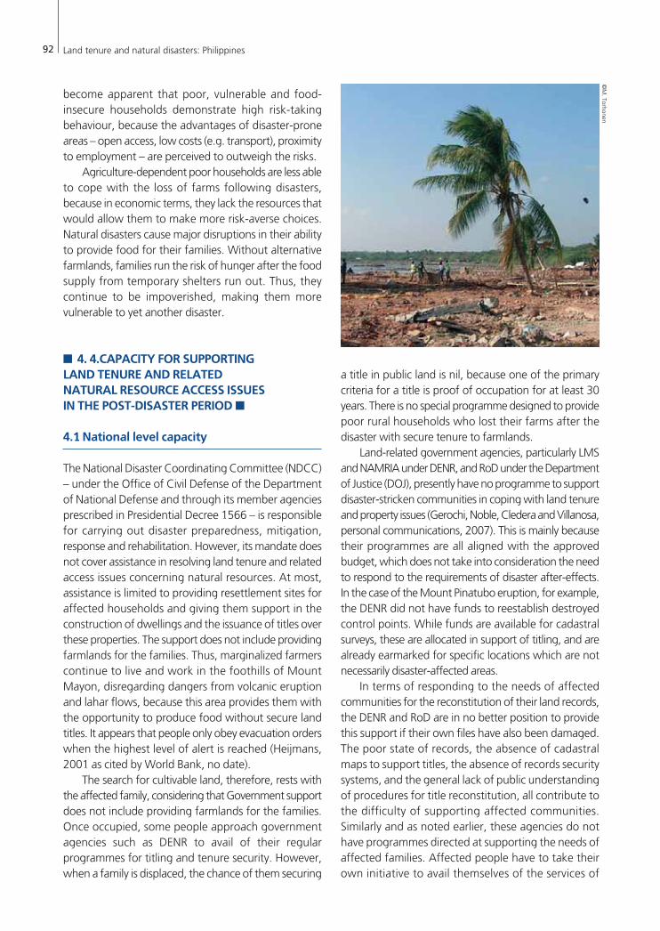
become apparent that poor, vulnerable and food-insecure households demonstrate high risk-takingbehaviour, because the advantages of disaster-proneareas – open access, low costs (e.g. transport), proximityto employment – are perceived to outweigh the risks.
Agriculture-dependent poor households are less ableto cope with the loss of farms following disasters,because in economic terms, they lack the resources thatwould allow them to make more risk-averse choices.Natural disasters cause major disruptions in their abilityto provide food for their families. Without alternativefarmlands, families run the risk of hunger after the foodsupply from temporary shelters run out. Thus, theycontinue to be impoverished, making them morevulnerable to yet another disaster.
� 4. 4.CAPACITY FOR SUPPORTING LAND TENURE AND RELATED NATURAL RESOURCE ACCESS ISSUES IN THE POST-DISASTER PERIOD �
4.1 National level capacity
The National Disaster Coordinating Committee (NDCC)– under the Office of Civil Defense of the Departmentof National Defense and through its member agenciesprescribed in Presidential Decree 1566 – is responsiblefor carrying out disaster preparedness, mitigation,response and rehabilitation. However, its mandate doesnot cover assistance in resolving land tenure and relatedaccess issues concerning natural resources. At most,assistance is limited to providing resettlement sites foraffected households and giving them support in theconstruction of dwellings and the issuance of titles overthese properties. The support does not include providingfarmlands for the families. Thus, marginalized farmerscontinue to live and work in the foothills of MountMayon, disregarding dangers from volcanic eruptionand lahar flows, because this area provides them withthe opportunity to produce food without secure landtitles. It appears that people only obey evacuation orderswhen the highest level of alert is reached (Heijmans,2001 as cited by World Bank, no date).
The search for cultivable land, therefore, rests withthe affected family, considering that Government supportdoes not include providing farmlands for the families.Once occupied, some people approach governmentagencies such as DENR to avail of their regularprogrammes for titling and tenure security. However,when a family is displaced, the chance of them securing
a title in public land is nil, because one of the primarycriteria for a title is proof of occupation for at least 30years. There is no special programme designed to providepoor rural households who lost their farms after thedisaster with secure tenure to farmlands.
Land-related government agencies, particularly LMSand NAMRIA under DENR, and RoD under the Departmentof Justice (DOJ), presently have no programme to supportdisaster-stricken communities in coping with land tenureand property issues (Gerochi, Noble, Cledera and Villanosa,personal communications, 2007). This is mainly becausetheir programmes are all aligned with the approvedbudget, which does not take into consideration the needto respond to the requirements of disaster after-effects.In the case of the Mount Pinatubo eruption, for example,the DENR did not have funds to reestablish destroyedcontrol points. While funds are available for cadastralsurveys, these are allocated in support of titling, and arealready earmarked for specific locations which are notnecessarily disaster-affected areas.
In terms of responding to the needs of affectedcommunities for the reconstitution of their land records,the DENR and RoD are in no better position to providethis support if their own files have also been damaged.The poor state of records, the absence of cadastralmaps to support titles, the absence of records securitysystems, and the general lack of public understandingof procedures for title reconstitution, all contribute tothe difficulty of supporting affected communities.Similarly and as noted earlier, these agencies do nothave programmes directed at supporting the needs ofaffected families. Affected people have to take theirown initiative to avail themselves of the services of
©M
. Torhonen

Land tenure and natural disasters: Philippines 93
9 Funding for cadastral surveys after a disaster is allocated only for delineating the boundaries of properties in the resettlement sites, and not to relocate lostboundary marks on the original properties of affected households.10 For example, repeated requests by NAMRIA for funding to support the reestablishment of control points in Mount Pinatubo have not been successful. Suchrequests have only been approved in 2007 (Gerochi, personal communication, 2007).11 An excellent example is Marikina City, which used part of its development funds to implement high budget flood control measures, and to relocate hundredsof households from the banks of Marikina River to a safer resettlement site where most important socio-economic facilities and services were provided. Theeffects on families when the river swells during annual heavy rains are thereby minimized.
these agencies, and go through the normal processthat other regular clients are subject to.
The budgets of disaster funds do not cover theexpenses required by the agencies to reconstitute theirrecords, reestablish control points, conduct cadastralsurveys,9 or provide land title reconstitution servicesfor affected families. If the agencies were to providethis support they would have to submit themselves tothe regular process of budget preparation and approval,and make a case for additional funding to betterrespond to the needs of affected families10.
In order to provide better land administration services,the agencies would have to improve their records systems,enhance public understanding of the procedures, andstreamline the processes to be more transparent andclient-responsive. They would also have to develop morepreventive approaches to be better placed to serve theneeds of affected families in the event of disasters. Thesewould include, among others: (i) providing for bettersecurity of records; creating backup copies: moresystematic organization of records to improve access bythe public; regular updating; improving consistency inrecords held by agencies (ii) identifying alternative areasfor agricultural production for affected families (iii)relocating vulnerable communities to safer areas andproviding secure tenure and farms. Improving awarenessof land tenure and resource access issues is also important,so that these agencies and other humanitarianorganizations can identify and implement more responsiveprogrammes for marginalized and vulnerable households.
Non-governmental organizations based in Manila,such as the Institute of Church and Social Issues (ICSI) andthe Citizens’ Disaster Response Center (CDRC), recognizethat land tenure issues are not given priority in currentdisaster emergency relief and rehabilitation programmes(Adem and Lanada, personal communications, 2007).However, CDRC undertakes ongoing activities withaffected communities such as the community mappingof properties affected by disasters (in partnership withlocal NGOs and LGUs), to facilitate tracking down andlocating the former properties of affected communities,and to help avoid disputes among neighbours (Lanada,personal communication, 2007).
4.2 Local level capacity
The NDCC structure is replicated at the local level – ineach region, province, city, municipality and barangay.At the municipal level, the LGUs are expected to providedirect support for the needs of affected communitieswithin their jurisdictions, with assistance from the fieldoffices of national government agencies. Under the LocalGovernment Code of 1991, the LGUs are required to setaside 5 percent of their estimated revenue from regularsources as a ‘Calamity Fund’. This amount is used forrelief, rehabilitation, reconstruction, and other works andservices carried out during the budget year. But onceagain, this amount does not cover support for addressingland tenure and related natural resource access issues.
As part of the LGU mandate, land-use planning isundertaken by the municipal and provincial governments.However, this exercise is not always informed by riskassessment and hazard mapping. Very few LGUs –although Marikina City is an exceptional case – have activeprogrammes to relocate communities vulnerable tohazards and informal settlers, and provide them withsecure tenure in safer environments. Few cities andmunicipalities also have the capacity to prevent settlementin disaster-prone areas, particularly by informal settlers.Local land-use policies, rules and regulations, are seldomenforced, even when they exist. In some cases, LGUsallow the entry of informal settlers, as a deliberate vote-raising strategy, even in more high-risk areas (World Bankand NDCC, no date).
The performance of LGUs in disaster managementis very diverse. They are expected to draw up riskmanagement plans, but may not put them into practice,particularly in the 4th to 6th class LGUs. Where plans doexist, they focus largely on relief and rescue operations(World Bank and NDCC, no date). Given their existingfiscal situation and manpower capacity, it is difficult formany LGUs to incorporate land tenure and naturalresource access issues in their disaster management plans,or in their local development plans. To date, very fewLGUs have been successful in implementing disasterprevention or flood control measures, and in relocatinghighly-vulnerable households to safer environments11.

94
Albay Public Safety and Emergency Management Office, Provincial Disaster Operation Center. Risk analysis of populationand households by municipality /city. No date.
Albay Public Safety and Emergency Management Office, Provincial Disaster Operation Center. No date. Updated Laharhazards assessment for critical Barangays of Albay.
Asian Disaster Management News, 8:4. Albay province, Philippines: coexisting with Mayon volcano and countermeasuresfor disaster preparedness. October–December 2002.
Asian Disaster Response Center. 20th century Asian natural disasters data book. 2002. Brown, O., Crawford, A. & Hammill, A. March 2006. Natural disasters and resource rights. International Institute for Sustainable
Development.Brown, O. & Crawford, A. July 2006. Addressing land ownership after natural disasters. International Institute for Sustainable
Development.Citizens’ Disaster Response Center. Annual reports 1991–2005. Citizens’ Disaster Response Center. 1992. Disasters: The Philippine experience. Manila, Martin Publishing Services.Conda, E.I. 2007. 13–15 March 2007. Practical data use for disaster prevention. Paper presented during the 3rd JPTM, Singapore.De Guzman, Emmanuel M. No date. Eruption of Mount Pinatubo in the Philippines in June 1991. Asian Disaster Reduction
Center.Duque, Priscila. Philippines country report 1999. A Paper presented to the 2nd Asian Disaster Reduction Center International
Meeting, 6–8 December 1999, Kobe, Japan.Fitzpatrick, Daniel. July 2005. Restoring and confirming rights to land in tsunami affected Aceh. UNDP/OXFAM Report.Freeman, Paul K., Michael Keen & Muthukumara Mani. September 2003. Being prepared. finance and development.Jabines, A. & Jasper Inventor. 2007. The Philippines: A climate hotspot and climate change impacts. Greenpeace.Jose, Aida M. & Nathaniel A. Cruz. 1999. Climate change impacts and responses in the Philippines’ water resources. Climate
Research Volume 12:77–84.LAMP–DENR. 2002. Land laws policy study.LAMP–DENR. 2003. Land market study.LAMP–DENR. 2004. Land tenure study. Book 1 – results.LAMP–DENR. 2004. Review of laws, policies, and Institutional set-up on tenancy in the Philippines.Landslides in Leyte: revisiting the survivors of the landslides. Regional Emergency Psychosocial Support Network. Volume
5: 1–2. January–June 2006. Memorandum for MMDA Chairman. July 31, 2000. Summary report on the Payatas landslide.Naerssen, Ton Van. Squatter access to land in Metro Manila. Philippine Studies Volume 41, First Quarter 1993.National Statistical Coordination Board (in cooperation with the WB). November 2005. Estimation of local poverty in the
Philippines.NDCC. No date. Brief analysis of tropical cyclones (TCs) occurrences (1970–2003)NDCC. No date. El Niño phenomenon, January to August 1998.NDCC. No date. Ranking of disasters in the Philippines.NDCC. No date. Statistics on tropical cyclones in the Philippine area of responsibility.NDCC. No date. Statistics on destructive typhoons. 1970–2006.NDCC. No date. Summary of disasters in the Philippines covering the period 1970–2006.Office of Civil Defense, NDCC. No date. Earthquake reports (1968–2003).Office of Civil Defense, NDCC. No date. Final report of tropical ‘Uring’ and preliminary report of DENR on Ormoc city tragedy.Office of Civil Defense, National Disaster Management Center. Media Advisory: Ls–St. Bernard as of 21 February 2006.Office of Civil Defense. 22 March 2006. Executive summary of the landslide in St Bernard, Southern Leyte.Office of Civil Defense. 2 January 2004. Memorandum to RDs, OCDRS 8 and CARAGA. Conduct of Joint UN–NDCC Needs
Assessment Mission.Pomeroy, R., B. Ratner, S. Hall, J. Pimoljinda & V. Vivekanandan. 2006. Rehabilitating livelihoods in tsunami affected
coastal communities in Asia. Worldfish Center.
Bibliography

Land tenure and natural disasters: Philippines 95
Provincial Disaster Coordinating Council. Albay District, Legazpi City. February 2007. Typhoon Reming final activity anddamage report.
Republic of the Philippines, Office of the President, Housing and Urban Development Coordinating Council, PinatuboProject Management Office. 2004. Transition report: June 2004.
Seitz, Stefan. 2004. The Aeta at the Mount Pinatubo, Philippines : A minority group coping with disaster. Quezon City, NewDay Publishers.
Shimizu, Hiromu. 1989. Pinatubo Aytas: continuity and change. Quezon City, Ateneo de Manila University Press.Tatsuki, Shiego, Haruo Hayashi, Doracie B. Zoleta–Nantes, Michiko Bamba, Koichi Hasegawa & Keiko Tamura. 2004.
The impact of risk perception, disaster schema, resources, intention, attitude and norms upon risk averse behavior amongMarikina city residents: structural equation modeling with latent variables.
Vitug, M. D. 1993. The politics of logging: power from the forest. Manila, Philippine Center for Investigative Journalism.Yamal, B., & Frazier, T. 2007. Mount Pinatubo: physical and human dimensions of the 1991 eruption. Essay for GEOG 333:
Human dimensions of natural hazards.
Web sites
East West Center. 2005. After the tsunami – human rights of vulnerable populations. (Available at http://www.reeeliefweb.int/rw/rwb.nsf/db900SID/VBOL–6JEE3A?OpenDocument)
Bangko Sentral ng Pilipinas (Central Bank of the Philippines). Economic accounts. (Available at http://www.bsp.gov.ph/statistics/speiy/gnpico_9101.htm)
Bureau of Agricultural Statistics. Philippine agricultural economy. (Available at http://www.bas.gov.ph/ agri_dev.php)Bureau of Agricultural Statistics. Selected statistics on number of employed people in agriculture, gross value added in agriculture,
fishery and forestry, and average annual rural income (1990–2006). (Available at http://countrystat.bas.gov.ph/PX/Dialog/Saveshow.asp)
Cola, Raoul M. Household and communities in a post-earthquake situation: lessons on survival and self-reliance. The July 16 Luzonearthquake. (Available at http://www.philvocs.dost.gov.ph?Earthquake/1990LuzonEQ_Monograph/pp207.html)
Delfin Jr., Francisco. 2006. Guinsaugon tragedy: issues and prescriptions. UP–NCPAG News. (Available at http://ip–ncpag.org/press)Environmental Science for Social Change. 2007. The Aurora–Quezon–Nueva Ecija disaster. (Available at http://essc.org.ph)Gutierrez, Jason. 2007. Hope and despair, one year after the Philippine mudslide. (Available at http://www.reliefweb.int/rw/
RWB.NSF/db900SID/EKOI–6YGA27?OpenDocument&rc–)Aida, J., Hilario, F. and Cruz, N. Operational agrometeorological services: national perspectives. Operational Agrometeorological
Services in the Philippines. (Available at http://www.wamis.org/ agm/pubs/agm9/agm9p01.pdf)Leckie, Scott. The great land theft. COHRE. (Available at www.cohre.org)Mapping Philippine vulnerability to environmental disasters. 2005. Manila Observatory. Center for Environmental Geomatics.
(Available at http://www.observatory.ph/vm/risk_maps.html)Mercado, Remigio A., Jay Bertham T. Lacsamana & Pineda, G. 1999. Socioeconomic impacts of the Mount Pinatubo eruption.
(Available at http://pubs.usgs.gov/pinatubo/mercado/index.html)Economic accounts. National Statistical Coordination Board. (Available at http://www.nscb.gov.ph/secstat/ d_accounts.asp)Natural disasters’ impact worsened by poverty – Analysts. (Available at http://services.inquirer.net/print.php? article_id=36026)Philippine disasters. (Available at http://www.txtmania. com/trivia/disasters.php)Destructive earthquakes in the Philippines and earthquake reports. Philippine Institute of Volcanology and Seismology. (Available
at http://www.philvocs.dost. gov.ph?DestructiveEQ.htm)Severino, Howie. 2007. Ormoc revisited. (Available at http://www.pcij.org/stories/1992/ormoc.html)Southern Leyte rehabilitation programme. Philippine Business for Social Progress. (Available at http://leytelandslide–rehab.blogspot.com/)The ten worst typhoons in the Philippines (1947–2002). (Available at http://www.typhoon2000.ph/stats/10WorstPhilippine
Typhoons.htm)The southern Leyte–Surigao landslides and floodings: A geohazard perspective. Republic of the Philippines – Mines and Geosciences
Bureau – Department of Environment and Natural Resources. (Available at MGB Homepage, http://www.mgb.gov.ph).Twigg, John. Disasters, development and vulnerability.Vicente, May Celine T.M., Jose Ramon T. Villarin, SJ, Geraald Galgana, Ma. Aileen Leah G. de Guzman, and Joel de Mesa. 2006.
The urban poverty morphology project: RS–GIS applications for Metro Manila. (Available at http://www.observatory.ph/vm/)World Bank and National Disaster Coordinating Council, Republic of the Philippines. No date. Natural disaster risk management
in the Philippines: enhancing poverty alleviation through disaster reduction. (Available at http://sitesources.worldbank.org/)
96
A and D alienable and disposable
ADRC Asian Disaster Response Center
CDRC Citizens’ Disaster Response Center
DA Department of Agriculture
DENR Department of Environment and Natural Resources
DOJ Department of Justice
GDP Gross Domestic Product
GDRP Gross Domestic Regional Product
GIS geographic information system
HLURB Housing and Land Use Regulatory Board
ICSI Institute for Church and Social Issues
LAMP Land Administration and Management Project
LGU local government unit
LMB Land Management Bureau
LMS Land Management Services
MGB Mines and Geosciences Bureau
NAMRIA National Mapping and Resource Information Authority
NASA Neighborhood Association for Shelter Assistance
NDCC National Disaster Coordinating Council
NSCB National Statistical Coordinating Board
OCD Office of Civil Defense
PAGASA Philippine Atmospheric and Geophysical and Astronomical Services Administration
PHILVOCS Philippine Volcanology and Seismology
RoD Register of Deeds
TOR Terms of Reference
Abbreviations and Acronyms