AquaHydro Lajana HPP Cascade
32
Ladjanuri HPPs cascade On the river Ladjanuri Feasibility study of technical-economic practicability of the river Ladjanuri HPPs cascade AQUAHYDRO ENERGY LTD The information presented in this report is confidential
-
Upload
anca-ciuchi -
Category
Documents
-
view
39 -
download
10
description
AquaHydro Lajana HPP Cascade
Transcript of AquaHydro Lajana HPP Cascade

Ladjanuri HPPs cascade On the river Ladjanuri
Feasibility study of technical-economic practicability of the river Ladjanuri HPPs cascade
AQUAHYDRO ENERGY LTD
The information presented in this report is confidential

Ladjanuri HPPs cascade on the river Ladjanuri Feasibility study of technical-economic practicability Of the river Ladjanuri HPPs cascade
AQUAHYDRO ENERGY LTD
2
1. TABLE OF CONTENTS
2. Site location and basic parameters ......................................................................................... 3
3. Topographic map of potential course site territory ................................................................ 6
4. Brief geological data of site location, geological map ............................................................ 9
5. Seismic data of the site location and the map ...................................................................... 13
6. hydrological and meteorological data ................................................................................... 17
7. Energy calculations and hydraulics ........................................................................................ 23
8. Infrastructure ......................................................................................................................... 29
9. Connection to the network ................................................................................................... 31
10. Estimated calculation ......................................................................................................... 31
11. Economic and Financial Analysis ....................................................................................... 32

Ladjanuri HPPs cascade on the river Ladjanuri Feasibility study of technical-economic practicability Of the river Ladjanuri HPPs cascade
AQUAHYDRO ENERGY LTD
3
2. SITE LOCATION AND BASIC PARAMETERS
1. Construction of Lajanuri HPP cascade is planned on the river Ladjanuri. The river Ladjanuri flows from the spring of Lalashkha Mountain (3152,7 m) which is located on 2380 meters high and 3 km long to the south-west of Lechkhumi Ridge and joins the river Rioni from the right side, at the Alpana village on 367 (m) plot.
Project location map.
The length of the river is 32 km, full drop - 2013 m, The average slope - 63 ‰, the catchment area - 296 km², the average height - 1490 m.
82 large and small tributaries runs into the river, on the total length 179 km. Network frequency of river basin is 0.71 km / km².
The basin of the river has an asymmetrical shape, which is located on the western part of Lechkhumi southern slope. It is bordered by the rivers Askistskali from the east and Tskhenistkali watersheds from the west. Boundary goes along the Letchkhumi ridge from the north. The length of the basin is 29 km, average width - 10.2 km.
Ladjanuri HPPs cascade on the river Ladjanuri Feasibility study of technical-economic practicability Of the river Ladjanuri HPPs cascade
AQUAHYDRO ENERGY LTD
4
The surface of the basin is characterized by mountainous relief. It is highly dissected by numerous tributaries of erosive deep gorges, whose sides are aslope enough, some sections are steep. Absolute heights on Letchkhumi watershed ridge reach 2700-3100m. The highest mountains are: Lelashkha (3152,7 m), Zieti (2908,6 m), Rovali (2771,0 m), Tetenari (2962,6 m) etc.
Mountainous zone of the basin is formed by crystal shale and limestone. In the rest of the area cretaceous limestone is dominated. The bedrocks are mainly covered by the clay soils, which are bare (on the upper part) in some places.
On the upper and lower flow of the basin is covered with herbaceous plants. Mainly, here is a mixed forest: oaks, beeches, fir trees, chestnuts and hornbeams. In the downstream dense forest is not found, mainly bushes and arable lands are found. Wooded part of the basin is approximately 70%.
The river gorge is V-shape. In some area - on 27-32 km and 1,7-4,5 km from the mouth of the river has a valley shape. The width at the bottom of the gorge is mostly 70-80m, whereas 10-20m in the gorge.
The gorge slopes mainly have a convex shape. The slopes between the S. Orbeli and S. Usaxelo are concave.
The slope of sides is generally 25-30 °, whereas at the river mouth station is 50-60°.
Sides are dissected by numerous ravines of the tributaries and gullies which at create fans the mouths that are built by a piece of materials.
The surface grounds of the sides are mainly clayey, rarely - arenaceous.
In 1960 the construction of Lajanuri HPP arch dam finished, which created the reservoir. The river Ladjanuri is fed by snow, rain and ground waters. The regime of aqueous is characterized by the spring floods, summer-autumn flooded conditions and sustainable low waters of winter.

Ladjanuri HPPs cascade on the river Ladjanuri Feasibility study of technical-economic practicability Of the river Ladjanuri HPPs cascade
AQUAHYDRO ENERGY LTD
5
The cascade consists of three HPPs, schemes include the following typical components:
Low threshold dam, jigger headlamps and fish ladder; closed grid of desilter camera, fish-protection grid; penstock / diversion canal with forebay tank; power knot, which is equipped by two horizontal axis Francis type turbines; access roads..
The main technical parameters of the Ladjanuri 1 HPP are:
Gross head- 100 m; type of dam - low threshold dam, height - 3 m, width - 40 m; Metal penstock, length - 3000 m, diameter - 0.8 m; Amount of turbines 2, Type - Francis horizontal axis; Power - 4.3 MW; Average output- 27.17 GWh;
The main technical parameters of the Ladjanuri 2 HPP are:
Gross head - 104 m; type of dam - low threshold dam, height - 3 მ, width - 50 m; Metal penstock, length - 3500 m, diameter 2,0 m; Amount of turbines 2, Type - Francis horizontal axis; Power - 5,8 MW; Average output - 37.58 GWh;
The main technical parameters of the Ladjanuri 3 HPP are:
Gross head - 100 m; type of dam - low threshold dam, height - 3 მ, width - 50 m; diversion channel 3000 m, 2,0X2,5 m; Amount of turbines 2, Type - Francis horizontal axis; Power - 7.1 MW; Average output - 39.70 GWh;

Ladjanuri HPPs cascade on the river Ladjanuri Feasibility study of technical-economic practicability Of the river Ladjanuri HPPs cascade
AQUAHYDRO ENERGY LTD
6
Grid connection:
For connection the mantioned HPPs with the system the following issues are necessary:
1. To construct 35 kV transmission line “Ladjanurihesi 1 –Ladjanurihesi 2 ".
2. To construct 35 kV transmission line ”Ladjanurihesi 2 –Ladjanurihesi 3 ".
3. To arrange 110/35/10 or 6 kV strain substation on Ladjanuri HPP territory.
1. A) To poach the existing 110 kV transmission line ’’ Jakhunderi “ on 110 kV of Ladjanuri HPP 3 (Ladjanuri HPP- Jakhunderi SS).
2. B) To enter 35 kV transmission line of “Ladjanurihesi 2 - Ladjanurihesi 3“ on 35 kV tire of Ladjanuri HPP 3
3. HPPs connection with Ladjanuri will provoke the necessity of Ladjanuri HPP reconstruction because of the limited capacity of 110/35/10 kV transformers of Ladjanuri HPP
Cost - Ladjanuri HPP 1 - 6.2 million US dollars, Ladjanuri HPP 2 - 8,7 million US dollars and Ladjanuri 3 - 10.5 million US dollars. Total value of cascade - 25,5 million US dollars.
3. TOPOGRAPHIC MAP OF POTENTIAL COURSE SITE TERRITORY
Tipography of site location is presented below on 1:25’000 scale map:

Ladjanuri HPPs cascade on the river Ladjanuri Feasibility study of technical-economic practicability Of the river Ladjanuri HPPs cascade
AQUAHYDRO ENERGY LTD
7
Displacement area of sites 1:25’000 map and plan.

Ladjanuri HPPs cascade on the river Ladjanuri Feasibility study of technical-economic practicability Of the river Ladjanuri HPPs cascade
AQUAHYDRO ENERGY LTD
8
Location of Ladjanuri 1 HPP intakes
Diversion penstock route of Ladjanuri 1 HPP
Location of Ladjanuri 2 HPP intakes
Diversion penstock route of Ladjanuri 2 HPP
Location of Ladjanuri 3 HPP intakes
Location of ladjanuri 3 HPP building

Ladjanuri HPPs cascade on the river Ladjanuri Feasibility study of technical-economic practicability Of the river Ladjanuri HPPs cascade
AQUAHYDRO ENERGY LTD
9
4. BRIEF GEOLOGICAL DATA OF SITE LOCATION, GEOLOGICAL MAP
Ladjanuri 1
According to tectonic view, the project area is included in Gagra-Java zone of the Greater Caucasus orogeny system and includes east part of Khaishi subzone. With the Geomorphological point of view of the study area represents the high and medium mountainous erosion relief, which is developed on the low and middle Jurassic age and Sori and Bajocian volcanogenic sedimentary substrate set.
Both slopes of the river Ladjanuri is presented by the middle series coarse of Bajocian argillite-bandaite tuff breccias and porphyrites (J1hd2) and Sori subset clay shales and quartzian sandstones and allevrolites (J1s2
Modern river alluvium is represented with grove and upper grove terrace formations, cobbles, pebbles of sand and clayey fillers. The rocks are friable unbound and weakly bound.
); rocks are cliffy and semi cliffy, whith a typical Rocky-grained and grained gritty residual soil.
Within the study area from the slope-type processes mainly diluvial and colluvial processes are found, with a small capacity of 0.5 or 3.2 m. Lithological structure is quite monotonous and is presented with clays, clay loam and a large number of coarse-grained material inclusions.
within the trial territory the tectonic and geodynamic processes (landslides, floods, etc.) haven’t been observed.
Ladjanuri 2
According to tectonic zoning the project area spreads to the Greater Caucasus Bajocian volcanic formations at the top of the Upper Juri and cretaceous carbonate precipitates of the southern slope of orogeny system Sori shales Gagra-Java spreading zone and in particular, includes the upper and lower sub-Khaishi Sori subset formations.

Ladjanuri HPPs cascade on the river Ladjanuri Feasibility study of technical-economic practicability Of the river Ladjanuri HPPs cascade
AQUAHYDRO ENERGY LTD
10
According to the geomorphological point of view of the river Ladjanuri middle relief it is the erosion-denudational relief, which is developed in the lower and middle subsuits of Juri on Sori substrates, with the traces of ancient and modern glacial.
Both slopes of the river in presented with the dark-grained sandstones and with the quartzian small-grained sandstones and allevrolites (J2s2) and dark gray shales rare middle layers of sandstones (J13s1
Rocks are semi cliffy. They are characterized by gravelly grained and gravelly clay of residual soil.
).
It should be noted that from the quaternary formations along the left bank englacial water formations are spread on 2-3km and 0,5-0,6 km distance. Precipitationს are represented by mixture of boulders, nodules and pebbles. The stock material shows that the precipitation capacity reaches 8 meters.
At the left tributary streams of river Ladjanuri, Sasarashvili Ghele and Lashighele water englacial precipitations powerful alluvial fan is accumulated. Other small power of the alluvial fans is marked at the mouth of the small streams.
Alluvial deposits are represented by the mixture of nodules, pebbles and sand the small size boulder inclusions of the river Ladjanuri. The floodplain and upper floodplain terraces are built with this material.
Within the working area tectonic dislocations and geodynamic processes (mudflows, landslides, etc.) have not been observed.
Ladjanuri 3
According to the tectonic division the project site, as well as the previous two complexes spread the southern slope of the Greater Caucasus orogeny system in Gagra-Java zone and include Sub-Khaishi zone of the upper and lower Sori subsuite formations.

Ladjanuri HPPs cascade on the river Ladjanuri Feasibility study of technical-economic practicability Of the river Ladjanuri HPPs cascade
AQUAHYDRO ENERGY LTD
11
According to geomorphological point of view upstream area of the river Ladjanuri is erosion-denudation relief, which is developed in the lower and middle subsets of Juri on Sori substrates. With the traces of ancient and modern glacial, the formations of river upstream Sori top subsets are represented by and dark grey clay shales, fine-grained sandstone and middle layers of allevrolites (J2s2
The rocks of Sori subsuite are semi cliffy. Residual soil is gravelly grained and gravelly clay. Diversion pipes or channel are carried to the left side, it’s desirable if it’s in main rocks. To the east part of hydropower plant landslide area is marked.
); the capacity of subsuit 450 m; Sori rocks are represented by dark-colored shale sequences is lower subsuit, wind-kvartsuli grained sandstones. Capacity of subsuit is 450 m; after that the upper subsuite of Sori repeats in the south wing of the anticline.

Ladjanuri HPPs cascade on the river Ladjanuri Feasibility study of technical-economic practicability Of the river Ladjanuri HPPs cascade
AQUAHYDRO ENERGY LTD
12

Ladjanuri HPPs cascade on the river Ladjanuri Feasibility study of technical-economic practicability Of the river Ladjanuri HPPs cascade
AQUAHYDRO ENERGY LTD
13
5. SEISMIC DATA OF THE SITE LOCATION AND THE MAP
Georgia and whole Caucasus locate between the Black and Caspian seas within a wide deformation zone, which is part of the Alps-Himalayan collisional belt. The movement of Arabian plate to the north towards the Eurasian plate determined the main picture of region tectonics. Continental collision caused the orogeny and uplifted the Greater Caucasus Range, which is currently the highest mountain in the Alps-Himalayan belt of the western segment of the system. Here happens the collision of the two continental plates: Arabian plate moves northward and collides with the Eurasian plate. Collision of plates generates two types of fault systems: the type of fault rupture in Iran and Turkey and thrusts type of decomposition in the Caucasus.
From the general seismicity of the 80-90s increasing seismic activity is observed, which indicators are powerful earthquakes which happened one by one: in 1988 M = 7.0 Spitak earthquake in Armenia, in 1991 M = 7.0 Racha earthquake, in 1992 M = 6.5 Barisakho earthquake in Georgia, in 1993 M = 7.3 Erzincan earthquake in Turkey. Active faults are mostly located on the borders of tectonic blocks. Across the Caucasus, latitudinal direction faults should be noted. Such trends have a number intrazonal fault. Most of these faults are endogenous.
According to the technical quality of the lability Georgian territory is distributed in five large geotechnical units: I- Antiklinorium of Caucasus Mountain range II- the southern slope of the Caucasus folded system, III- belt of Georgia (Mtatusheti), IV- V- Adjara-Trialeti folded system and belt of Artvis-Bolnia (Armenia), see map.
The watershed of the river Ladjanuri is located in the southern slope of the Caucasus II _ folded system of II4 Gagra-Java Zone in Racha-Lechkhumi syncline subsuit, which was represented the Geosinklin of the upper Palaeozoic, Mesozoic and lower Palaeogene time. It is constructed by partly volcanogenic and huge thick sedimentary formations. The entire system is characterized by intense folded and southern derivation. Here are developed strong compressed isoclinal and asymmetric common Caucasian directional linear wrinkles.

Ladjanuri HPPs cascade on the river Ladjanuri Feasibility study of technical-economic practicability Of the river Ladjanuri HPPs cascade
AQUAHYDRO ENERGY LTD
14
Analysis of seismic data indicates that this is average seismic region. The magnitude of strong earthquakes is equal to 7, and the micro seismic intensity is 9 Ball. (MSK scale units) Recurrence period of major earthquakes are types of 103-104 year.
The different seismic catalogs were used for Seismic analysis: earthquake catalog of seismic monitoring center, special catalog for the Caucasus within the framework of the global seismic hazard evaluation program, catalog of strong earthquakes.

Ladjanuri HPPs cascade on the river Ladjanuri Feasibility study of technical-economic practicability Of the river Ladjanuri HPPs cascade
AQUAHYDRO ENERGY LTD
15
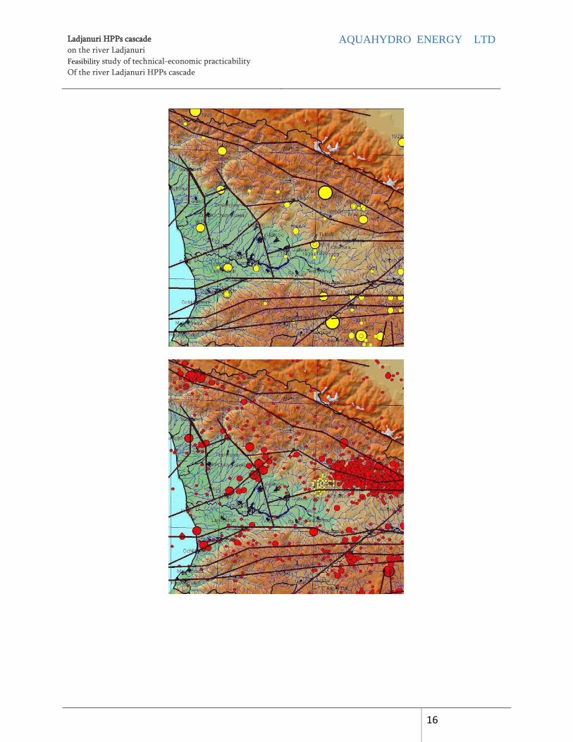
The study area (Central Caucasus) is one of the most seismically active district in Georgia. Map shows epicenter catalog map of the historical earthquakes (only medium and strong earthquakes are marked M>3)
In the instrumental observation period the region was distinguished with greater seismic active, particularly noteworthy is the epicentric zone of Racha earthquake in 1991. Racha earthquake was the most large-scale seismic event on the territory of Georgia. Earthquake magnitude M = 7.0, while the intensity of the epicenter was 9 ball. The epicenter was located in the mountainous villages of Racha and Imereti.
Racha earthquake is related to active fault of Gagra-Java. The active area of the earthquake still is active seismically. The measurement data shows that the movement of the earth's crust in this region is quite intensive, about 4-5 mm per year. The same movement speed has the intermountain area towards the central part of the Caucasus folded system. This contemporary data are in good arrangement with geological and seismic surveys.
Georgia’s Seismic zoning is constituted by the Institute of Geophysics of Georgia was shown on the map, according to which the cascade of Ladjanuri HPPs is located by magnitude of 9 Ball earthquake zone.
Ladjanuri HPPs cascade on the river Ladjanuri Feasibility study of technical-economic practicability Of the river Ladjanuri HPPs cascade
AQUAHYDRO ENERGY LTD
16

Ladjanuri HPPs cascade on the river Ladjanuri Feasibility study of technical-economic practicability Of the river Ladjanuri HPPs cascade
AQUAHYDRO ENERGY LTD
17
6. HYDROLOGICAL AND METEOROLOGICAL DATA
6.1. Hydrological data
In 1959-1990 years the measurements of water flows were carried out at the village Orbeli section on the river Ladjanuri, that’s why the average amount of watershed-count method was used.
From the analog station, the recount of water was carried out according to the section of the water catchment area - in direct proportion.
The area of the river Ladjanuri at the Orbeli checkpoint section consists - 231 km2, whereas the average water flow is 8.90 m3 / s in project sections, on the basis of it on the power plants recount water costs was carried out, see the table below:

Ladjanuri HPPs cascade on the river Ladjanuri Feasibility study of technical-economic practicability Of the river Ladjanuri HPPs cascade
AQUAHYDRO ENERGY LTD
18
The average monthly cost of the river Lajanuri in project intersections.
The average monthly cost hydrographs of the river Lajanuri in project intersections.

Ladjanuri HPPs cascade on the river Ladjanuri Feasibility study of technical-economic practicability Of the river Ladjanuri HPPs cascade
AQUAHYDRO ENERGY LTD
19
Ladjanuri river gorge.

Ladjanuri HPPs cascade on the river Ladjanuri Feasibility study of technical-economic practicability Of the river Ladjanuri HPPs cascade
AQUAHYDRO ENERGY LTD
20
Watershed map.
6.2. Meteorological data
Climate. Watershed of the river Ladjanuri is located in the following humid subtropical climate subzones:
3 - Humid Climate. Moderate cold winter and long warm summer;
4 - Humid Climate. Cold winter and long cool summer;
5 - Humid Climate. Cold winter and short summer

Ladjanuri HPPs cascade on the river Ladjanuri Feasibility study of technical-economic practicability Of the river Ladjanuri HPPs cascade
AQUAHYDRO ENERGY LTD
21
6 -Alpine humid climate. Devoid of real summer;
Temperature. The average monthly, annual and extreme values of air temperature, according to meteorological perennial observation data of the station close to project cascade of the village Lailashi. See table:
Average -1.5 1.2 5.5 9 16.2 19.5 20 21 17 12 6.5 1.5 10.7
Lailashi Abs.Maksim 15 21 31 33 35 38 40 41 38 32 27 21 41
Abs.Maksim. -21 -17 -13 -4 1 5 9 8 2 -4 -12 -17 -21
Rainfalls. The average monthly rainfall and annual total amount of perennial observation data from the same meteorological station. See the table below:
NAAaverage monthly rainfalls and annual total amount in mm M
meteorological station
I II III IV V VI VII VIII IX X XI XII Yyear
Lailashi 98 102 101 105 108 110 93 84 106 116 99 107 1229
Snow. According to the meteorological perennial observation data of Lailashi meteorological station, the snow cover normally appears on 8.XII and disappears at 11.III. The average decade height of snow cover is 64 cm, and the maximum average decade height is 112 cm.
The emergence and disappearance of snow cover according to the multi-observations is shown on the below table.
Dates of emergence and disappearance of snow cover
meteorological station
Number of snowy days
Emergence date of snow cover Disappearance date of snow cover
Average Early Late L Average Early Late
Lailashi 72 8.XII. 13.X 22.II 11.III. 11.II. 3.IV

Ladjanuri HPPs cascade on the river Ladjanuri Feasibility study of technical-economic practicability Of the river Ladjanuri HPPs cascade
AQUAHYDRO ENERGY LTD
22
The table shows the snow cover different provision values of the maximum multi-decade heights according to the observation data of Lentekhi meteorological station:
Snow cover different provision values of the maximum decade heights (cm)
meteorological station
Provision P %
95 90 75 50 25 10 5 1
LLailashi 6 9 17 41 62 85 98 138
Humidity. Air humidity characteristics, according to the multi-observation data of Lailashi meteorological station is given in the table:
Air humidity meteorological
station Humidity
I II III IV V VI VII VIII IX X XI XII Year
LLailashi
absolut.m
b
5.7
5.9
6.8 9.3 13.4 16.8 19.5 19.3 15.8 11.3 8.4 6.4 11.6
percent % 84 82 77 72 72 74 75 75 78 83 80 84 78
Deficit. m
b
1.3 1.5 2.7 5.0 6.4 7.4 8.1 8.1 6.1 3.9 2.6 1.6 4.6
Wind. In the district the wind is blowing in all directions, but the prevailing eastern and western winds, which is caused by the direction of the river Ladjanuri. The table below shows the wind directions and the number of stills according to multi-observation data.
Wind directions and annual number of stills in %
Wind directions and annual number of stills in %
meteorological station
NN NNN.E E S.E S S.W W NN.WN Still
LLailashi 2 9 47 2 0 3 21 7 58
The below table shows the monthly and annual average wind speed:

Ladjanuri HPPs cascade on the river Ladjanuri Feasibility study of technical-economic practicability Of the river Ladjanuri HPPs cascade
AQUAHYDRO ENERGY LTD
23
Monthly and annual average wind speed in m / s meteorological
station Vane height I II III IV V VI VII VIII IX X XI XII YYear
LLailashi 10 m. 1.8 1.8 2.1 2.5 2.3 2.3 2.3 2.4 1.8 1.7 1.9 2.1 2.1
The following table shows different maximum velocities of Lentekhi meteorological according to the multi-observation data.
The maximum wind speed in m / s
meteorological station
Maximum wind speed (m / s) available one-time
1 Year 5 Years 10 Years 15 Years 20 Years
LLLailashi 11 13 14 15 17
7. ENERGY CALCULATIONS AND HYDRAULICS
Energy report of HPPs is based on average monthly data. During the energy report drop the ecological water losses in the hydraulic scheme, effectiveness of aggregates and the amount of working aggregates, efficiency of the generator and other parts is taken into account.

Ladjanuri 1 HPP energy calculation based on the multiannual average monthly expenses are listed in the following table:
Ladjanuri 1 HPP energy calculation.

Ladjanuri HPPs cascade on the river Ladjanuri Feasibility study of technical-economic practicability Of the river Ladjanuri HPPs cascade
AQUAHYDRO ENERGY LTD
25
Ladjanuri 2 HPP energy calculation based on the multiannual average monthly expenses are listed in the following table:
Ladjanuri 2 HPP energy calculation.

Ladjanuri HPPs cascade on the river Ladjanuri Feasibility study of technical-economic practicability Of the river Ladjanuri HPPs cascade
AQUAHYDRO ENERGY LTD
26
Ladjanuri 3 HPP energy calculation based on the multiannual average monthly expenses are listed in the following table:
Ladjanuri 3 HPP energy calculation

Lajanuri HPPs cascade capacities according to months.

Ladjanuri HPPs cascade on the river Ladjanuri Feasibility study of technical-economic practicability Of the river Ladjanuri HPPs cascade
AQUAHYDRO ENERGY LTD
28
Ladjanuri HPPs cascade output according to months.

Ladjanuri HPPs cascade on the river Ladjanuri Feasibility study of technical-economic practicability Of the river Ladjanuri HPPs cascade
AQUAHYDRO ENERGY LTD
29
8. INFRASTRUCTURE
Construction district from the village Orbeli is far from 2-10 km, while from Tbilisi - 330
km. In the project area about 8000 m long of HPP road implementation works and the new 3,000 m long way have to carry out (along the diversion channel), see the topographic map.
The road in the gorge of river Ladjanuri

Ladjanuri HPPs cascade on the river Ladjanuri Feasibility study of technical-economic practicability Of the river Ladjanuri HPPs cascade
AQUAHYDRO ENERGY LTD
30

Ladjanuri HPPs cascade on the river Ladjanuri Feasibility study of technical-economic practicability Of the river Ladjanuri HPPs cascade
AQUAHYDRO ENERGY LTD
31
9. GRID CONNECTION For connection of Ladjanuri 1, Ladjanuri 2 and Ladjanuri 3 to the system following issues are necessary: 4. To construct 35 kV transmission line “Ladjanurihesi 1- Lajanurihesi 2 ". 5. To construct 35 kV transmission line “Ladjanurihesi 2 -Lajanurihesi 3 ". 6. to arrange 110/35/10 kV or 6 kV substation on the territory of Lajanuri HPP 3.
A) To poach the existing 110 kV transmission line ’’ Jakhunderi “ on 110 kV of ladjanuri HPP 3 (Ladjanuri HPP- Jakhunderi SS).
B) To enter 35 kV transmission line of “Ladjanurihesi 2 - Ladjanurihesi 3“ on 35 kV tire of Ladjanuri HPP 3
7. HPPs connection with Ladjanuri will provoke the necessity of Ladjanuri HPP reconstruction because of the limited capacity of 110/35/10 kV transformers of Ladjanuri HPP
10. ESTIMATED CALCULATION
The table below shows the estimated project cost:
Thus, total investment value of cascade is 25.5 million US dollars.

Ladjanuri HPPs cascade on the river Ladjanuri Feasibility study of technical-economic practicability Of the river Ladjanuri HPPs cascade
AQUAHYDRO ENERGY LTD
32
11. ECONOMIC AND FINANCIAL ANALYSIS
According to cascade estimate, the investment amount is 25.5 million US dollars, which is about 1.5 million US dollars per MW. Cascade generates 104.57 GWh electricity, in regard to the sale price of the electricity - 53 USD / MWh, the price of sold electricity costs 5.20 million US dollars per year. In the financial analysis of the project the following assumptions were provided:
• The total capital expenditure - 6,2 / 8,7 / 10,5 million US dollars in accordance with Ladjanuri 1 / Ladjanuri 2/ Ladjanuri 3 HPPs;
• The duration of the construction work - 2 years for each HPP; • loans and capital proportion in investments - 60% / 40%; • The payable interest rate on the loan - 10%; • Price of electricity - 5.3 USD / MW / h.
With regard to the above mantioned assumptions and evaluation of the preliminary financial results are as follows:
Consequently, due to the profitability of the projects, their implementation is recommended.