Appendix B Community Outreach Details
47
B Community Outreach Details Appendix
Transcript of Appendix B Community Outreach Details

B Community Outreach Details
Appendix
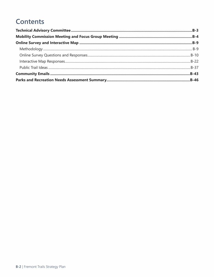
ContentsTechnical Advisory Committee ....................................................................................................................B-3Mobility Commission Meeting and Focus Group Meeting ......................................................................B-4Online Survey and Interactive Map ............................................................................................................B-9
Methodology .................................................................................................................................................................................. B-9Online Survey Questions and Responses ...........................................................................................................................B-10Interactive Map Responses ......................................................................................................................................................B-22Public Trail Ideas ..........................................................................................................................................................................B-37
Community Emails ......................................................................................................................................B-43Parks and Recreation Needs Assessment Summary ................................................................................B-46
B-2 | Fremont Trails Strategy Plan
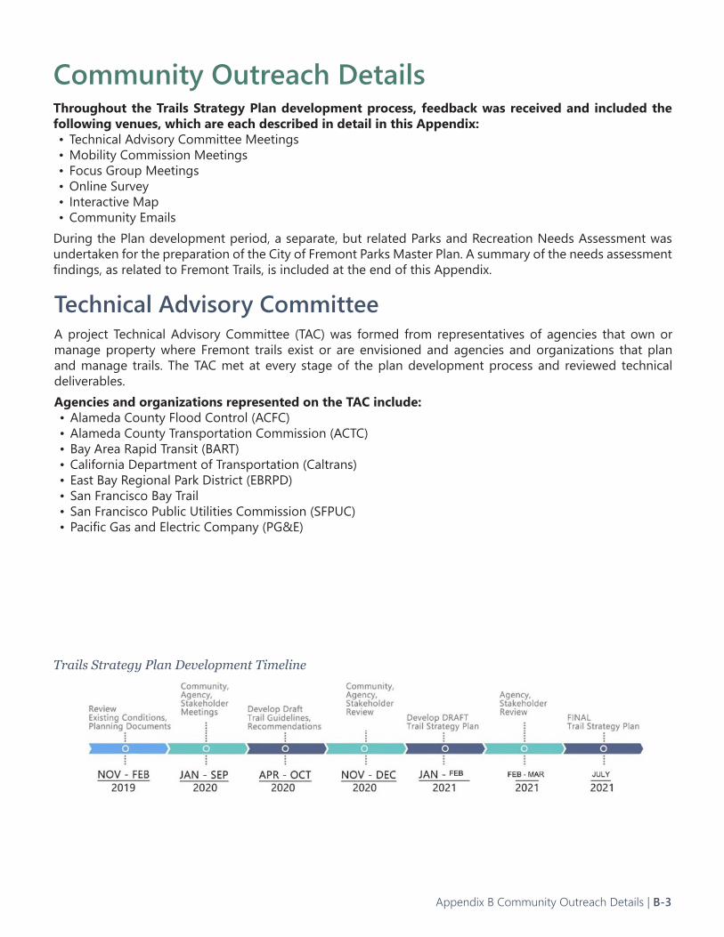
Community Outreach DetailsThroughout the Trails Strategy Plan development process, feedback was received and included the following venues, which are each described in detail in this Appendix:• Technical Advisory Committee Meetings• Mobility Commission Meetings• Focus Group Meetings• Online Survey• Interactive Map• Community Emails
During the Plan development period, a separate, but related Parks and Recreation Needs Assessment was undertaken for the preparation of the City of Fremont Parks Master Plan. A summary of the needs assessment findings, as related to Fremont Trails, is included at the end of this Appendix.
Trails Strategy Plan Development Timeline
Technical Advisory CommitteeA project Technical Advisory Committee (TAC) was formed from representatives of agencies that own or manage property where Fremont trails exist or are envisioned and agencies and organizations that plan and manage trails. The TAC met at every stage of the plan development process and reviewed technical deliverables.Agencies and organizations represented on the TAC include: • Alameda County Flood Control (ACFC)• Alameda County Transportation Commission (ACTC)• Bay Area Rapid Transit (BART)• California Department of Transportation (Caltrans)• East Bay Regional Park District (EBRPD)• San Francisco Bay Trail• San Francisco Public Utilities Commission (SFPUC)• Pacific Gas and Electric Company (PG&E)
Appendix B Community Outreach Details | B-3
Date: September 16, 2020 (virtual meeting)Members Present: Nisar Ahmed, Melissa Avery, Julie Huang, Flavio Poehlmann, Mark Spencer, Stephen Tu, Erin Vaca, Ken Wu
Members Absent: None
Staff Present: Hans Larsen, Public Works Director; Noe Veloso, Assistant City Engineer; Matthew Bomberg, Senior Transportation Engineer; Natalie Khwaja, Management Analyst II; Eliza Villaluz, Senior Office Specialist
Trails Strategy Plan Presentation: Randy Anderson from TrailPeople presented the Strategy Plan which consisted of project updates, schedules, design guidelines, prioritization framework and next steps.
Commissioner and Staff Comments:
•It was noted that the Alameda Creek Trail is currently being repaved by East Bay Regional Parks.
•Upgrades to existing trail to make them more suitable for transportation
•Melissa Avery mentioned connectivity issues – would like to see use numbers shift from recreation to transportation.
•Nisar Ahmed would like to prioritize safe routes to school trails.
•Currently 115 people are receiving the digital Mobility Newsletter and 80% are opening it. It can be used to promote participation in the Trails Strategy. The next issue will be in October.
•Hans Larsen suggested that Trails Strategy focus on a 5 year program of trail priorities that Fremont should focus on.
•Mark Spencer commented the key to Trails Strategy success is its relationship to the Parks Master Plan, the Bicycle Master Plan and the Pedestrian Master Plan – it should be carefully coordinated with those plans.
•Stephen Tu agreed with that comment.
•An E-bike usage policy would be desirable. Matt Bomberg noted that motorized scooters and bikes are not allowed on Lake Elizabeth trails.
Public Comment:
Gary Suplick: Was interested if there was a list of concerns from the public regarding the trails plan.
William Yragui: Would like to see more connections to the Bay Ridge Trail, Bay Trail and Greenway Trail
Mobility Commission Meeting Notes
Mobility Commission Meeting and Focus Group MeetingIn the fall of 2020, the preliminary online survey results and overview of the background studies for the Trails Strategy were presented to a virtual meeting of the Fremont Mobility Commission. A follow-up Focus Group meeting was held soon after. This meeting included select Mobility Commissioners and representatives of groups that promote and advocate for trails and biking. Minutes and notes from these meetings are included below.
B-4 | Fremont Trails Strategy Plan
Date: September 25, 2020 (virtual meeting)Attendees•Ken Wu, Mobility Commission•Mark Spencer, Chair Fremont Mobility Commission•William Yragui, Mission Peak Conservancy•Andreas Kadavanich, Bike Fremont•Steve Skala, Bicycle and Pedestrian Advocate
City of Fremont•Rene Dalton, Associate Transportation Engineer, Transportation Engineering Department•Matthew Bomberg, Senior Transportation Engineer, Transportation Engineering Department•Tara Bhuthimethee, Senior Landscape Architect and Project Manager, Parks and Recreation Master Plan
Consultant Team •Randy Anderson, TrailPeople•Megan Wooley-Ousdahl, Toole Design•Kerry Aszklar, Toole Design
Meeting notes Existing Trail Network
•Definition of a trail versus a shared-used path? Interest in differentiating the two here.
•Questions about the mileage that’s shown on the map.
•Need to differentiate on the map what’s on-street versus off-street trails.
•Trails need to have connections.
•Desirable trail qualities:
o Connect to destinations, facilitate north-south connections. Schools, businesses, churches, transit centers. Encourage people to get out of their cars.
Purpose and Vision of the Plan
Mark:
•Focus of the Mobility Commission – lower the single-occupancy mode share. We want to give people in Fremont choices. We have a disjointed network of trails, bicycle network, gaps in the pedestrian network. Want to integrate all the plans – how do the trails provide connectivity to the bicycle and pedestrian network.
•Fremont residents need mobility options. Our students need options to connect to schools – safe routes that avoid major corridors. The trail system can connect to schools, help with this. Want to provide options so students can bike to the schools, especially elementary. Destinations – Also have a lot of people coming into Fremont, via Bart, and dispersing to workplaces. Want to connect people from BART stations to employment hubs. Fremont residents need options, and so do people who commute to Fremont for work. How do all these plans (Pedestrian Master Plan, Bicycle Master Plan, Parks Master Plan and Trails Strategy) complement one another? And not compete against each other.
Andreas:
•The bicycle master plan basically punted on trails – acknowledged that trails are coming. Trails are unique – no vehicles, which makes them very safe. The more trails, the more people we are going to get.
•We need to lock down every piece of land that can support a trail as soon as possible, and connect to these areas. Would like an inventory of all the possibly available trail routes, and can prioritize which can be used for recreation, commuting, etc.
William:
Bicycle and Pedestrian Focus Group Meeting Notes
Appendix B Community Outreach Details | B-5
•The City is missing a vision – you have to look at the trail plan over a period of 20, 30 years. Believe today that we have 39 miles of trails. Then have to buy, improve, and maintain the trails over time.
•Recommendation: Put together a map that shows how the City could connect the trails over time – a plan for 30+ years.
Steve:
•Fremont needs a strategy for developing the trails network.
•Fremont has many smaller segments of trails. May be very challenging to connect one long trail segment across Fremont.
•Focus on local connections. Can identify areas that need connectivity (schools, shopping, neighborhoods), and develop trail segments in these smaller areas – and connect to the larger bicycle network and the pedestrian improvements.
Ken:
•Trails in Fremont have not been a focus of the city. Few miles added over 20 years.
•Short term: What quick and meaningful improvements can be done? Agrees that trails play important role in mode shift away from vehicular use. Trails complement bike and ped use. Pivot to connectivity to businesses and commuting is important.
•Trail issues: no lighting, no signage (need to clarify alternative routes), crowding - etiquette and connections to other trails and bike facilities, and far from ideal for practical reasons; uses trails only for recreation.
User Conflicts
•Andreas: East Bay Greenway Trail: signage for bikes and separation between bikes and peds because of speed. Commuting: high bike speeds. Lighting is important.
Tying in with the Parks and Recreation Master Plan
•Tara, City staff: Appreciates previous involvement of group in other plans. Understands issues brought up by the Focus Group. Can't commute to Fremont; commiserates with connectivity issues group brings up.
o As the project manager for the Parks & Recreation Master Plan, we are mapping schools, libraries, neighborhoods, and creating atlas of maps that group would enjoy. Wants to share this information, wants to break down silos. Says there is a shared vision.
Commuting
•Steve: Commuting on trail network - wants to take that off table. To get somewhere quickly, likely to use bike network and not the trail network. For family and for recreation, or access to school or weekend errands, would more likely take the trail. It’s important to identify the use of trail network.
•Andreas: I disagree; some trails are still good, direct routes with commuting in mind, and good connection to other trails. Some folks will go out of their way to access a trail to avoid cars.
•Ken: I agree, I have similar preference as a commuter. Maybe commuting is not a primary focus.
•Steve: For primary purpose: it shouldn't be commuting.
Trail Typology
• Matt, City of Fremont: Looking at different facilities and their purposes. The typology idea helps to classify trails by a hierarchy. Higher up - better connectivity and length, higher volume of users. Recommendations include separation and lighting. Lower on hierarchy: shorter distance trails, destinations not as big or as demanded as other destinations. Recommendations include not separating mode, lower level of amenities. The hierarchy framework is in development; great discussion so far.
Bicycle and Pedestrian Focus Group Meeting Notes, continued
B-6 | Fremont Trails Strategy Plan
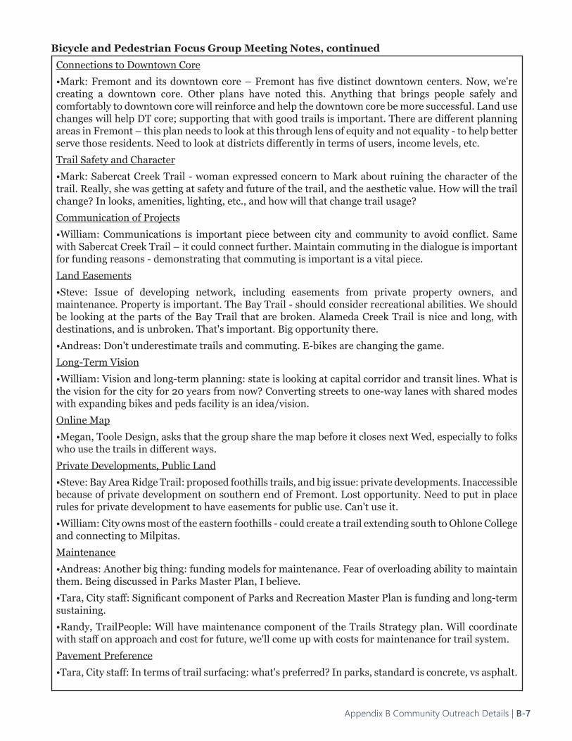
Connections to Downtown Core
•Mark: Fremont and its downtown core – Fremont has five distinct downtown centers. Now, we're creating a downtown core. Other plans have noted this. Anything that brings people safely and comfortably to downtown core will reinforce and help the downtown core be more successful. Land use changes will help DT core; supporting that with good trails is important. There are different planning areas in Fremont – this plan needs to look at this through lens of equity and not equality - to help better serve those residents. Need to look at districts differently in terms of users, income levels, etc.
Trail Safety and Character
•Mark: Sabercat Creek Trail - woman expressed concern to Mark about ruining the character of the trail. Really, she was getting at safety and future of the trail, and the aesthetic value. How will the trail change? In looks, amenities, lighting, etc., and how will that change trail usage?
Communication of Projects
•William: Communications is important piece between city and community to avoid conflict. Same with Sabercat Creek Trail – it could connect further. Maintain commuting in the dialogue is important for funding reasons - demonstrating that commuting is important is a vital piece.
Land Easements
•Steve: Issue of developing network, including easements from private property owners, and maintenance. Property is important. The Bay Trail - should consider recreational abilities. We should be looking at the parts of the Bay Trail that are broken. Alameda Creek Trail is nice and long, with destinations, and is unbroken. That's important. Big opportunity there.
•Andreas: Don't underestimate trails and commuting. E-bikes are changing the game.
Long-Term Vision
•William: Vision and long-term planning: state is looking at capital corridor and transit lines. What is the vision for the city for 20 years from now? Converting streets to one-way lanes with shared modes with expanding bikes and peds facility is an idea/vision.
Online Map
•Megan, Toole Design, asks that the group share the map before it closes next Wed, especially to folks who use the trails in different ways.
Private Developments, Public Land
•Steve: Bay Area Ridge Trail: proposed foothills trails, and big issue: private developments. Inaccessible because of private development on southern end of Fremont. Lost opportunity. Need to put in place rules for private development to have easements for public use. Can't use it.
•William: City owns most of the eastern foothills - could create a trail extending south to Ohlone College and connecting to Milpitas.
Maintenance
•Andreas: Another big thing: funding models for maintenance. Fear of overloading ability to maintain them. Being discussed in Parks Master Plan, I believe.
•Tara, City staff: Significant component of Parks and Recreation Master Plan is funding and long-term sustaining.
•Randy, TrailPeople: Will have maintenance component of the Trails Strategy plan. Will coordinate with staff on approach and cost for future, we'll come up with costs for maintenance for trail system.
Pavement Preference
•Tara, City staff: In terms of trail surfacing: what's preferred? In parks, standard is concrete, vs asphalt.
Bicycle and Pedestrian Focus Group Meeting Notes, continued
Appendix B Community Outreach Details | B-7
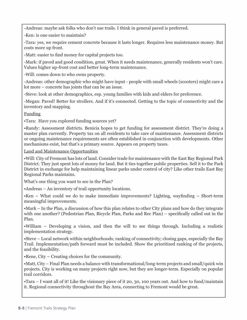
-Andreas: maybe ask folks who don't use trails. I think in general paved is preferred.
-Ken: is one easier to maintain?
-Tara: yes, we require cement concrete because it lasts longer. Requires less maintenance money. But costs more up front.
-Matt: easier to find money for capital projects too.
-Mark: if paved and good condition, great. When it needs maintenance, generally residents won't care. Values higher up-front cost and better long-term maintenance.
-Will: comes down to who owns property.
-Andreas: other demographic who might have input - people with small wheels (scooters) might care a lot more – concrete has joints that can be an issue.
-Steve: look at other demographics, esp. young families with kids and elders for preference.
-Megan: Paved! Better for strollers. And if it's connected. Getting to the topic of connectivity and the inventory and mapping.
Funding
•Tara: Have you explored funding sources yet?
•Randy: Assessment districts. Benicia hopes to get funding for assessment district. They're doing a master plan currently. Property tax on all residents to take care of maintenance. Assessment districts or ongoing maintenance requirements are often established in conjunction with developments. Other mechanisms exist, but that's a primary source. Appears on property taxes.
Land and Maintenance Opportunities
•Will: City of Fremont has lots of land. Consider trade for maintenance with the East Bay Regional Park District. They just spent lots of money for land. But it ties together public properties. Sell it to the Park District in exchange for help maintaining linear parks under control of city? Like other trails East Bay Regional Parks maintains.
What’s one thing you want to see in the Plan?
•Andreas – An inventory of trail opportunity locations.
•Ken – What could we do to make immediate improvements? Lighting, wayfinding – Short-term meaningful improvements.
•Mark – In the Plan, a discussion of how this plan relates to other City plans and how do they integrate with one another? (Pedestrian Plan, Bicycle Plan, Parks and Rec Plan) – specifically called out in the Plan.
•William – Developing a vision, and then the will to see things through. Including a realistic implementation strategy.
•Steve – Local network within neighborhoods; ranking of connectivity; closing gaps, especially the Bay Trail. Implementation/path forward must be included. Show the prioritized ranking of the projects, and the feasibility.
•Rene, City – Creating choices for the community.
•Matt, City – Final Plan needs a balance with transformational/long-term projects and small/quick win projects. City is working on many projects right now, but they are longer-term. Especially on popular trail corridors.
•Tara – I want all of it! Like the visionary piece of it 20, 30, 100 years out. And how to fund/maintain it. Regional connectivity throughout the Bay Area, connecting to Fremont would be great.
B-8 | Fremont Trails Strategy Plan
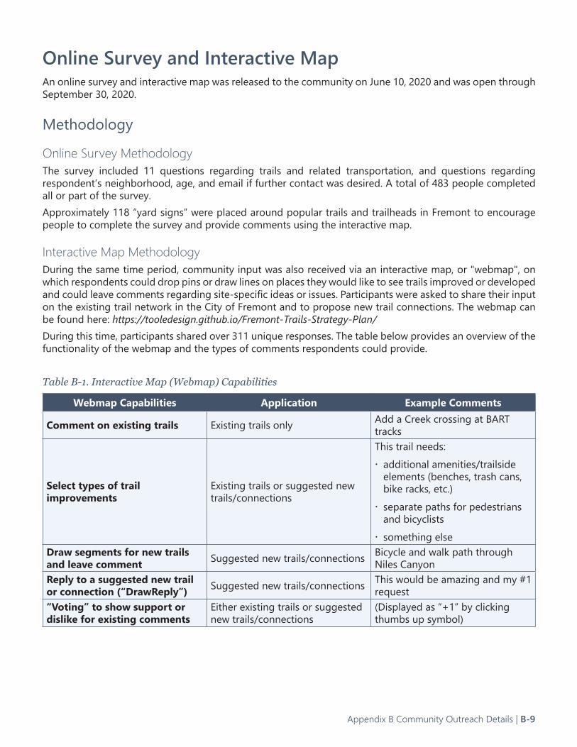
Online Survey and Interactive MapAn online survey and interactive map was released to the community on June 10, 2020 and was open through September 30, 2020.
Methodology
Online Survey MethodologyThe survey included 11 questions regarding trails and related transportation, and questions regarding respondent’s neighborhood, age, and email if further contact was desired. A total of 483 people completed all or part of the survey.Approximately 118 “yard signs” were placed around popular trails and trailheads in Fremont to encourage people to complete the survey and provide comments using the interactive map.
Interactive Map MethodologyDuring the same time period, community input was also received via an interactive map, or "webmap", on which respondents could drop pins or draw lines on places they would like to see trails improved or developed and could leave comments regarding site-specific ideas or issues. Participants were asked to share their input on the existing trail network in the City of Fremont and to propose new trail connections. The webmap can be found here: https://tooledesign.github.io/Fremont-Trails-Strategy-Plan/ During this time, participants shared over 311 unique responses. The table below provides an overview of the functionality of the webmap and the types of comments respondents could provide.
Table B-1. Interactive Map (Webmap) Capabilities
Webmap Capabilities Application Example Comments
Comment on existing trails Existing trails only Add a Creek crossing at BART tracks
Select types of trail improvements
Existing trails or suggested new trails/connections
This trail needs:x additional amenities/trailside elements (benches, trash cans, bike racks, etc.)x separate paths for pedestrians and bicyclistsx something else
Draw segments for new trails and leave comment Suggested new trails/connections Bicycle and walk path through
Niles CanyonReply to a suggested new trail or connection (“DrawReply”) Suggested new trails/connections This would be amazing and my #1
request“Voting” to show support or dislike for existing comments
Either existing trails or suggested new trails/connections
(Displayed as “+1” by clicking thumbs up symbol)
Appendix B Community Outreach Details | B-9
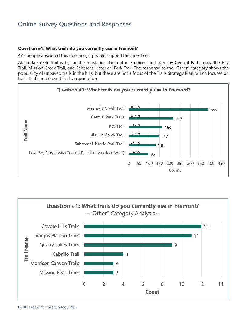
Question #1: What trails do you currently use in Fremont?477 people answered this question, 6 people skipped this question.Alameda Creek Trail is by far the most popular trail in Fremont, followed by Central Park Trails, the Bay Trail, Mission Creek Trail, and Sabercat Historical Park Trail. The response to the “Other” category shows the popularity of unpaved trails in the hills, but these are not a focus of the Trails Strategy Plan, which focuses on trails that can be used for transportation.
Online Survey Questions and Responses
B-10 | Fremont Trails Strategy Plan
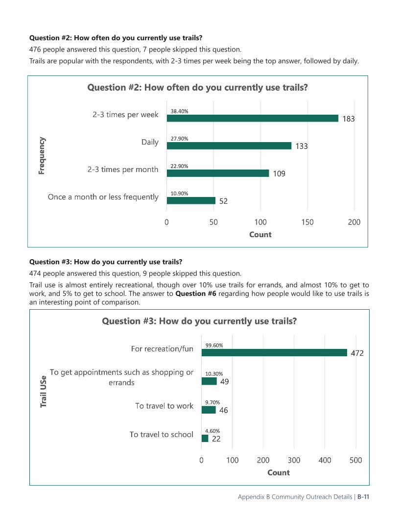
Question #2: How often do you currently use trails?476 people answered this question, 7 people skipped this question.Trails are popular with the respondents, with 2-3 times per week being the top answer, followed by daily.
Question #3: How do you currently use trails?474 people answered this question, 9 people skipped this question.Trail use is almost entirely recreational, though over 10% use trails for errands, and almost 10% to get to work, and 5% to get to school. The answer to Question #6 regarding how people would like to use trails is an interesting point of comparison.
Appendix B Community Outreach Details | B-11
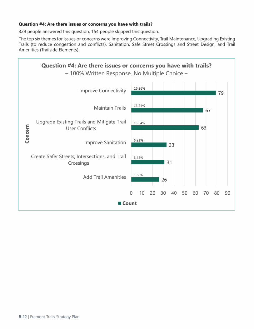
Question #4: Are there issues or concerns you have with trails?329 people answered this question, 154 people skipped this question.The top six themes for issues or concerns were Improving Connectivity, Trail Maintenance, Upgrading Existing Trails (to reduce congestion and conflicts), Sanitation, Safe Street Crossings and Street Design, and Trail Amenities (Trailside Elements).
B-12 | Fremont Trails Strategy Plan
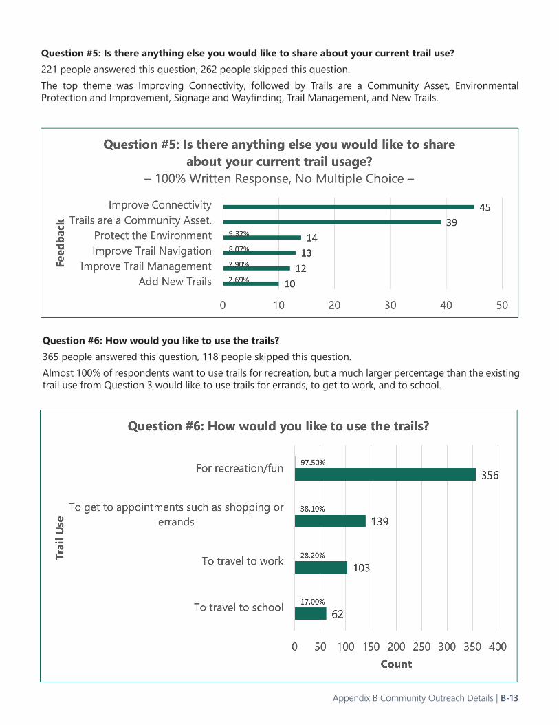
Question #5: Is there anything else you would like to share about your current trail use?221 people answered this question, 262 people skipped this question.The top theme was Improving Connectivity, followed by Trails are a Community Asset, Environmental Protection and Improvement, Signage and Wayfinding, Trail Management, and New Trails.
Question #6: How would you like to use the trails?365 people answered this question, 118 people skipped this question.Almost 100% of respondents want to use trails for recreation, but a much larger percentage than the existing trail use from Question 3 would like to use trails for errands, to get to work, and to school.
Appendix B Community Outreach Details | B-13
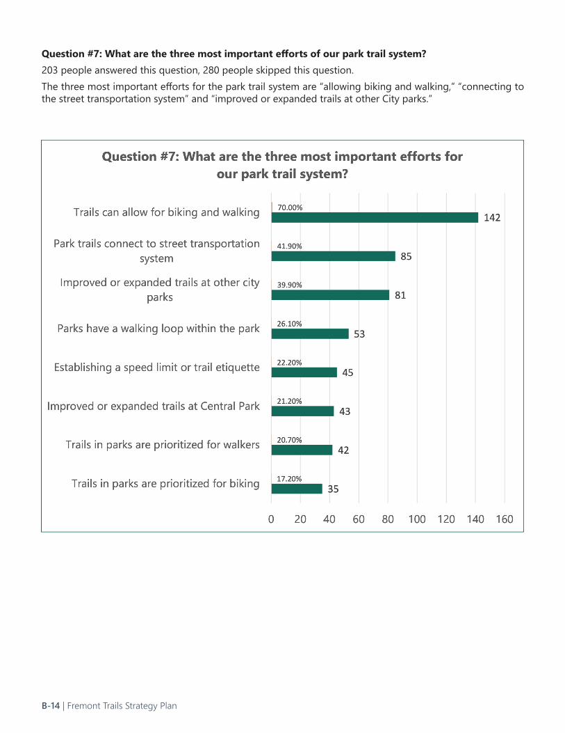
Question #7: What are the three most important efforts of our park trail system?203 people answered this question, 280 people skipped this question.The three most important efforts for the park trail system are “allowing biking and walking,” “connecting to the street transportation system” and “improved or expanded trails at other City parks.”
B-14 | Fremont Trails Strategy Plan
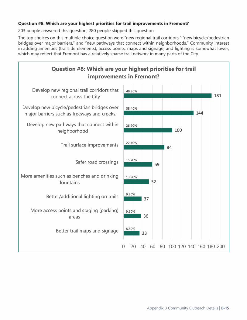
Question #8: Which are your highest priorities for trail improvements in Fremont?203 people answered this question, 280 people skipped this questionThe top choices on this multiple choice question were “new regional trail corridors,” “new bicycle/pedestrian bridges over major barriers,” and “new pathways that connect within neighborhoods.” Community interest in adding amenities (trailside elements), access points, maps and signage, and lighting is somewhat lower, which may reflect that Fremont has a relatively sparse trail network in many parts of the City.
Appendix B Community Outreach Details | B-15
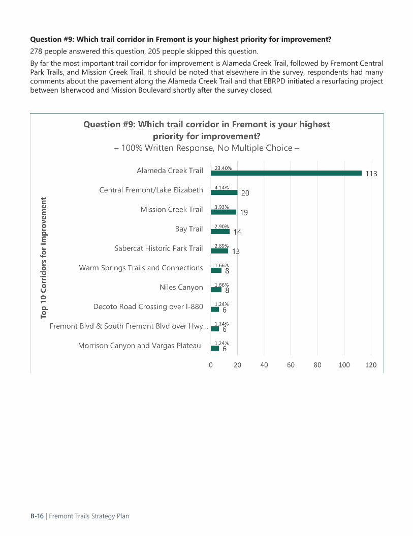
Question #9: Which trail corridor in Fremont is your highest priority for improvement?278 people answered this question, 205 people skipped this question.By far the most important trail corridor for improvement is Alameda Creek Trail, followed by Fremont Central Park Trails, and Mission Creek Trail. It should be noted that elsewhere in the survey, respondents had many comments about the pavement along the Alameda Creek Trail and that EBRPD initiated a resurfacing project between Isherwood and Mission Boulevard shortly after the survey closed.
B-16 | Fremont Trails Strategy Plan
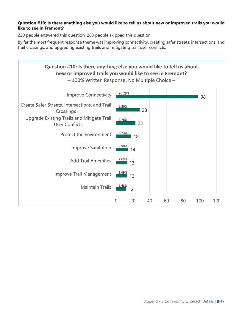
Question #10: Is there anything else you would like to tell us about new or improved trails you would like to see in Fremont?220 people answered this question, 263 people skipped this question.By far the most frequent response theme was improving connectivity, creating safer streets, intersections, and trail crossings, and upgrading existing trails and mitigating trail user conflicts.
Appendix B Community Outreach Details | B-17
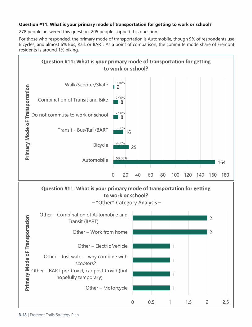
Question #11: What is your primary mode of transportation for getting to work or school?278 people answered this question, 205 people skipped this question.For those who responded, the primary mode of transportation is Automobile, though 9% of respondents use Bicycles, and almost 6% Bus, Rail, or BART. As a point of comparison, the commute mode share of Fremont residents is around 1% biking.
B-18 | Fremont Trails Strategy Plan
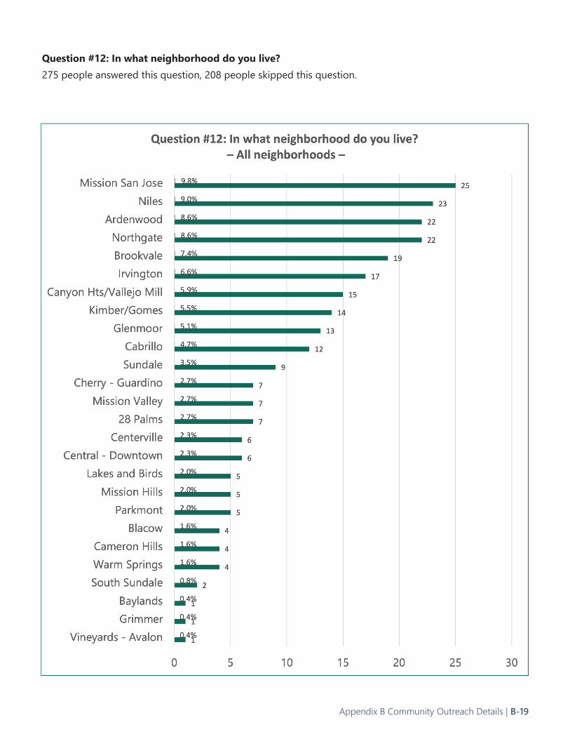
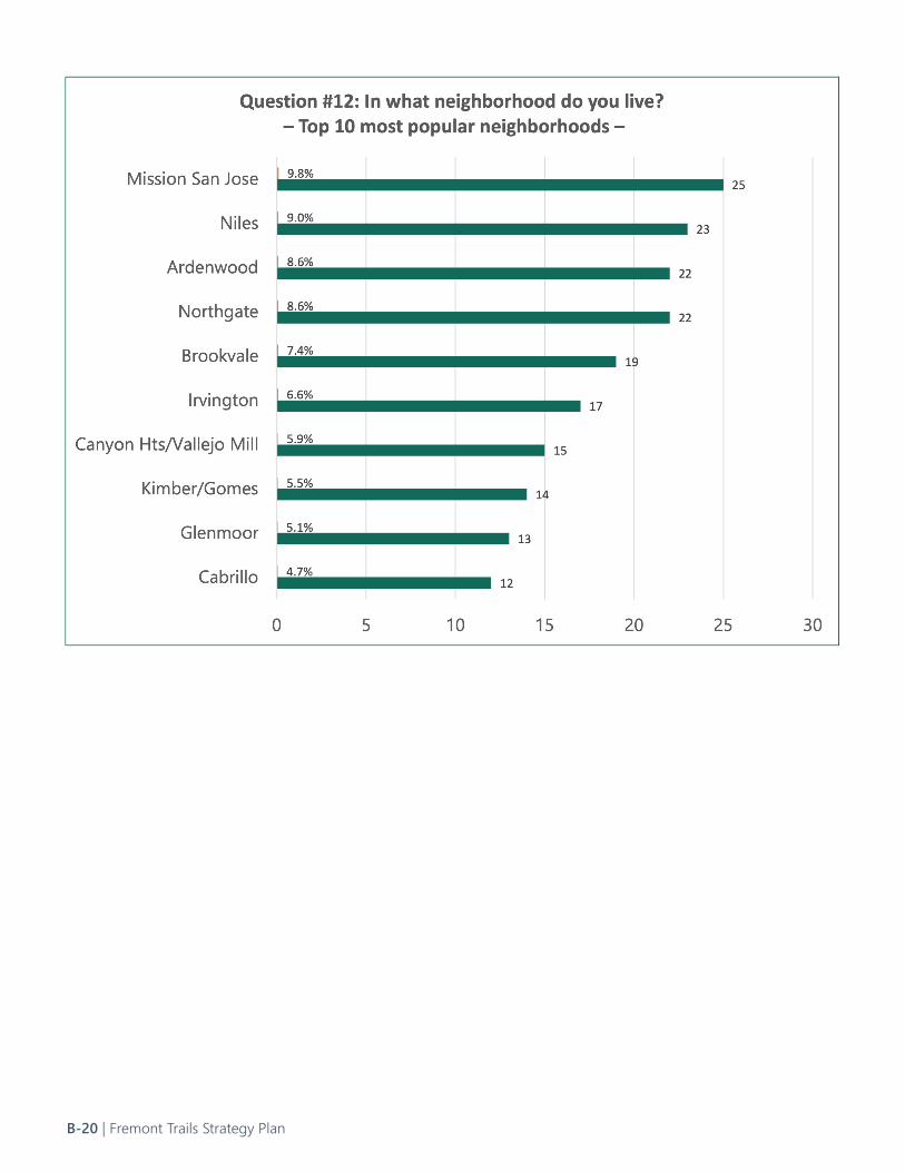
Question #12: In what neighborhood do you live?275 people answered this question, 208 people skipped this question.
Appendix B Community Outreach Details | B-19
B-20 | Fremont Trails Strategy Plan
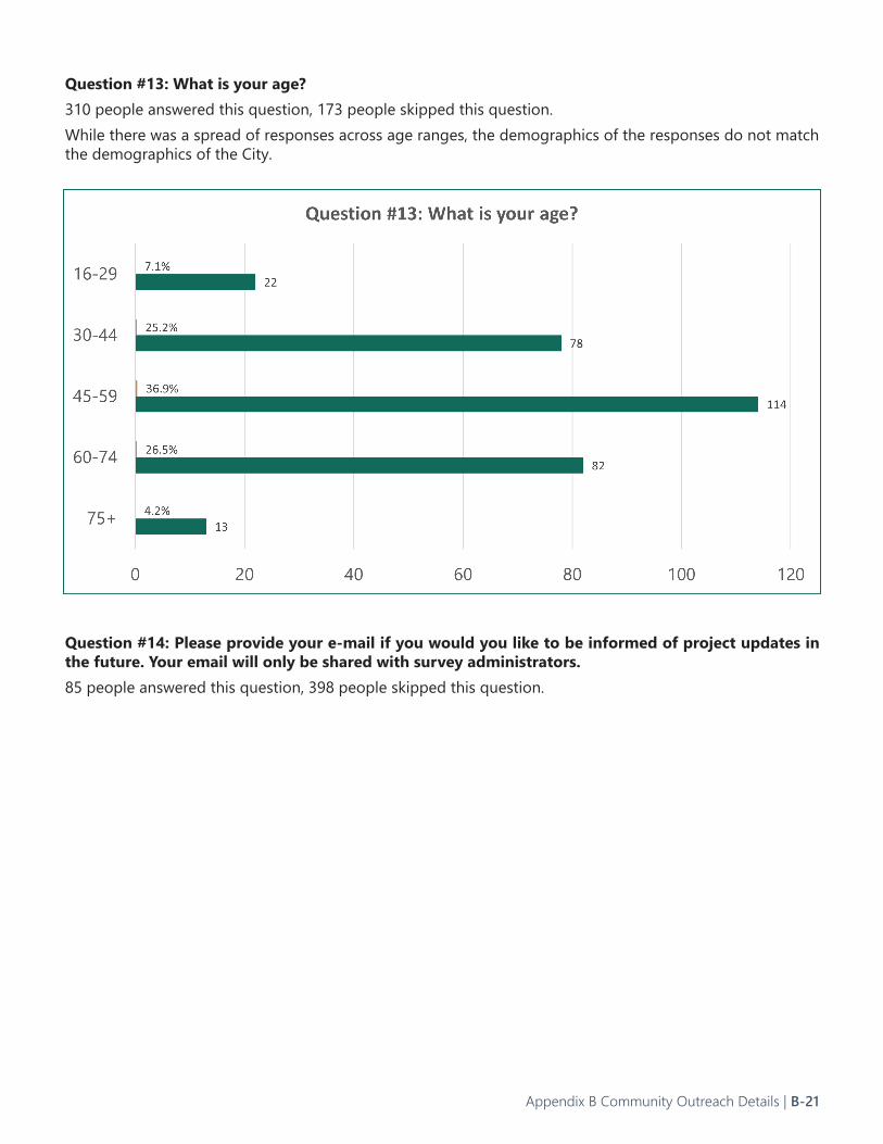
Question #13: What is your age?310 people answered this question, 173 people skipped this question.While there was a spread of responses across age ranges, the demographics of the responses do not match the demographics of the City.
Question #14: Please provide your e-mail if you would you like to be informed of project updates in the future. Your email will only be shared with survey administrators.85 people answered this question, 398 people skipped this question.
Appendix B Community Outreach Details | B-21
Interactive Map ResponsesCommunity members provided 311 responses on the interactive map, including comments on specific points as well as linear features. The graphic below summarizes the point-based and linear comments by quantity of responses.
Key TakeawaysPopular responses from community members:
• Responding to a comment or suggested trail from another participant (45 percent of responses)• Suggestions for new trails or trail connections (38 percent of responses)• Comments on existing trails (16 percent of responses)
Many community members commented on the Alameda Creek Trail, with comments ranging from:• Improving the pavement quality • Providing or removing vegetation• Improving trail crossings at major intersections
Popular new, suggested trails include:• A trail parallel to Niles Canyon Road• A trail connecting to the Hetch Hetchy Trail in Milpitas• A trail connecting the Alameda Creek Trail to the Fremont BART station
Locations for new connections, or desired crossings improvements, were proposed at:• Paseo Padre Parkway and Isherwood Way• Mission Boulevard crossing Alameda Creek• High Street and Main Street
A handful of comments suggested new cross-jurisdictional trails, such as a new trail connecting Fremont and Union City.
B-22 | Fremont Trails Strategy Plan
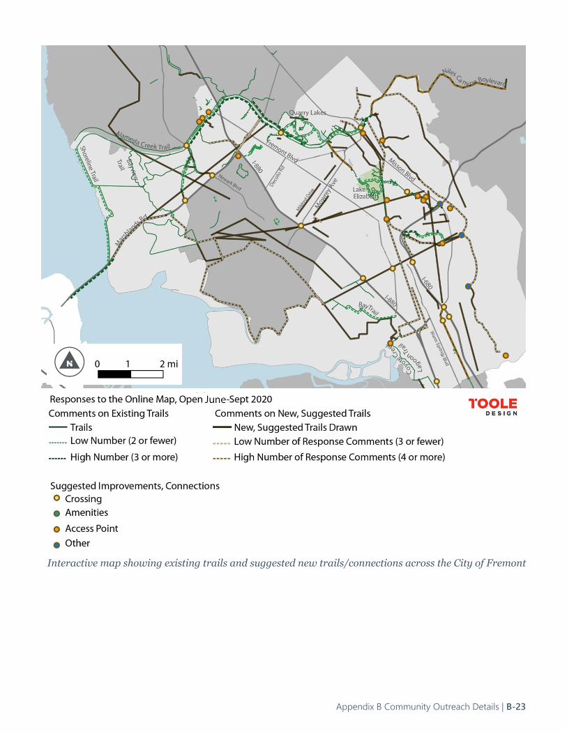
Interactive map showing existing trails and suggested new trails/connections across the City of Fremont
Appendix B Community Outreach Details | B-23
Interactive Map Comments by Theme and LocationOverall, there were 20 comments regarding crossings, 14 for access points, five related to “other,” and one for amenities. The following tables detail the specific comments.Table B-2. Suggested Trail Connections, CrossingsComment Location DescriptionNo crosswalk at busy street to user made access in poor condition
Falcon Drive and Peregrine Way
Connect sidewalk on each side of railroad crossing Pedestrians and bikers risk their life to get trough this restriction on Lowry Road
Alameda Creek Trail and Lowry Road, near Novato Street
Provide a sidewalk and safe crossing over Alameda Creek! Alameda Creek and Ardenwood Boulevard/Union City Boulevard
No comment Paseo Padre Parkway and 84No comment Ardenwood Boulevard and 84No comment Windemere Drive and Omaha PlaceThis intersection is scary. The problem is cars turning left from Isherwood onto Paseo Padre. The cars looking for a gap in traffic to make a left turn, so they don't look for pedestrians/bicyclists. Also because Paseo Padre is 3 lanes in each direction, pedestrians never know which of the three lanes the car will turn into, making it very hard for pedestrians to be safe. The many lanes also encourage drivers to cut in front or behind passing pedestrians. This intersection is important to connect the Brookvale trail to Quarry Lakes.
Paseo Padre Parkway and Isherwood Way
to cross creek to access downtown Niles from paved bike path Mission Boulevard and Alameda CreekRail tunnels need trail ped/bike access Mowry Avenue and Mission BoulevardI would love if the city added a safe access point with medium-sized parking for people to hike onto existing trails
Canyon Heights Drive and Morrison Canyon Road
Dangerous crossing for children to get to/from school Driscoll Road north of Chiltern DriveTraveling south on Mission Blvd. is fine until you reach the on ramp area to 680. Cyclists must negotiate two right turns, go under the freeway, and then try to cross the right turn to an eastbound 680. That's dangerous enough, but then the Mission Blvd. narrows just at McDonald's and it is a single lane that is very precarious and narrow for cyclists and cars. Please find a way to make this bicyclist friendly, or, find a new route to cross here.
Mission Boulevard and Interstate 680
Unsafe to cross 880 Interstate 880 and Mowry AvenueCurrently difficult to access Pacific Commons due to freeway crossing
Interstate 880 and Auto Mall Parkway
No bike lane, no sidewalk, heavy traffic; impossible to walk to shopping centers or bus stops bus stop (on Auto Mall east of Fremont Blvd) )is without sidewalk or bike lane as well
Auto Mall Parkway and Fremont Boulevard
B-24 | Fremont Trails Strategy Plan
Comment Location DescriptionThere is currently no safe pedestrian crossing over Hwy 680 between Grimmer Blvd and Washington.
Interstate 680 and Durham Road
Old Mission Park has a parking lot and bathroom, but the trails stemming from Old Mission Park are disjointed. It would be great if you could add a safe crossing and connection to Sabercat trail's Pine Street entrance here.
Old Mission Park
The new 262 project should include a path that connects segments of Hetch Hetchy.
Interstate 680 and Mission Boulevard
Warren has cars moving at high speeds. If a new trail is added, having more design focused changes to slow down cars (in addition to the signal) would be great.
Warren Avenue near Bradley Street
There is not a good way to get to the Bay Trail in far South Fremont unless you go back up to Warren. This is a major barrier if wanting to take the Coyote Trail to work place in South Bay
Near Interstate 680 and Page Avenue
Table B-3. Suggested Trail Connections, Access PointsComment Location Description
Connect sidewalk on each side of railroad crossing Pedestrians and bikers risk their life to get trough this restriction on Lowry Road
Alameda Creek Trail and Lowry Road, near Novato Street
No crosswalk at busy street to user made access in poor condition
Falcon Drive and Peregrine Way
This area has a user made eroded dangerous access which has a concrete and stone park naming monument located there. Why welcome people from AC Trail to injure themselves sliding down the levee
Quarry Lakes Parkway
No comment Windemere Drive and Omaha Place
Rail tunnels need trail ped/bike access Mowry Avenue and Mission Boulevard
I would love if the city added a safe access point with medium-sized parking for people to hike onto existing trails
Canyon Heights Drive and Morrison Canyon Road
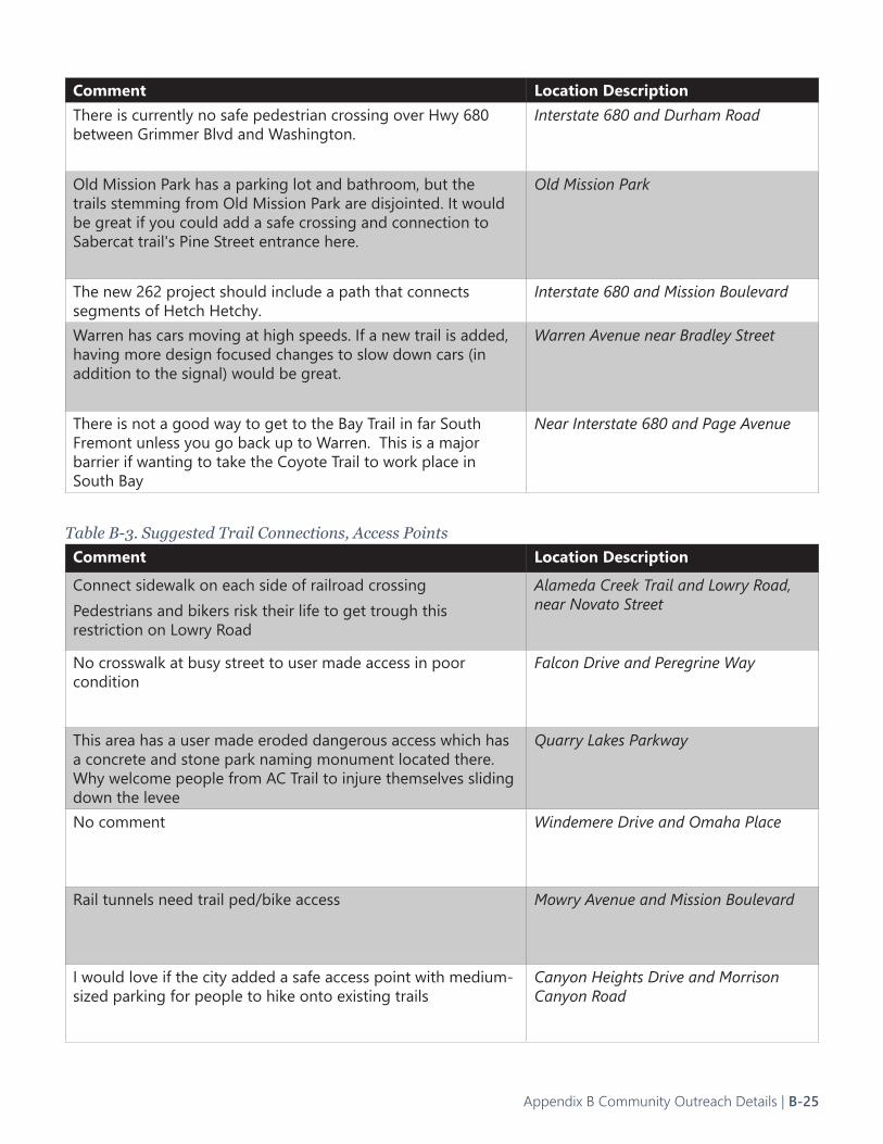
Appendix B Community Outreach Details | B-25

Comment Location Description
Enable a way to get onto Paseo Padre from the park Paseo Padre Parkway and Railroad Avenue
Improve flow between MSJHS and Hopkins with this trail Mission San Jose Park, southside
Add new trail access point as part of new Mission Creek Trail development
Trail near Palm Ave and Mission Creek Drive
No comment Palm Avenue at Corte Santa Ines
I would love an access point to Mission Peak and the trails here, with a medium-sized parking area. A lot of people use Mill Creek Road to detour walk into Mission Peak.
Mill Creek Road, north of Linmore Drive
Old Mission Park has a parking lot and bathroom, but the trails stemming from Old Mission Park are disjointed. It would be great if you could add a safe crossing and connection to Sabercat trail's Pine Street entrance here.
Old Mission Park
Connect to proposed Irvington Bart station Washington Boulevard and Osgood Road
Can we have more trails into Don Edwards Wildlife Refuge Coyote Creek Trail Lagoon
B-26 | Fremont Trails Strategy Plan
Table B-4. Suggested New Connections, OtherComment Location DescriptionTraveling south on Mission Blvd. is fine until you reach the on ramp area to 680. Cyclists must negotiate two right turns, go under the freeway, and then try to cross the right turn to an eastbound 680. That's dangerous enough, but then the Mission Blvd. narrows just at McDonald's and it is a single lane that is very precarious and narrow for cyclists and cars. Please find a way to make this bicyclist friendly, or, find a new route to cross here.
Mission Boulevard and Interstate 680
Dedicated trail parking for access to MP trails that is not subject to Ohlone College confusing parking rules and ticketing.
Aquatic Way and Pine Street
Expanded, improved parking to accommodate all of the visitors to Mission Peak
Stanford Avenue and Mission Creek Trailhead
Connect sidewalk on each side of railroad crossing Pedestrians and bikers risk their life to get trough this restriction on Lowry Road
Alameda Creek Trail and Lowry Road, near Novato Street
There is no access point to any trails in the hills in South Fremont because the end of Scott Creek is gated and closed to the public. The public has to detour 6 miles to access point in Milpitas to get back to trails in Fremont : (
Near Calaveras Road and Vista Ridge Drive
Table B-5. Suggested Trail Connections, Amenities
Commentt Location DescriptionImprove flow between MSJHS and Hopkins with this trail Mission San Jose Park, southside
Appendix B Community Outreach Details | B-27
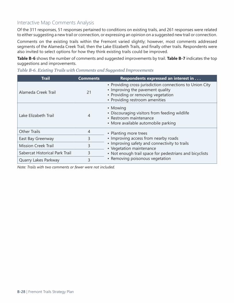
Interactive Map Comments AnalysisOf the 311 responses, 51 responses pertained to conditions on existing trails, and 261 responses were related to either suggesting a new trail or connection, or expressing an opinion on a suggested new trail or connection. Comments on the existing trails within the Fremont varied slightly; however, most comments addressed segments of the Alameda Creek Trail, then the Lake Elizabeth Trails, and finally other trails. Respondents were also invited to select options for how they think existing trails could be improved. Table B-6 shows the number of comments and suggested improvements by trail. Table B-7 indicates the top suggestions and improvements. Table B-6. Existing Trails with Comments and Suggested Improvements
Trail Comments Respondents expressed an interest in . . .
Alameda Creek Trail 21
• Providing cross-jurisdiction connections to Union City• Improving the pavement quality• Providing or removing vegetation• Providing restroom amenities
Lake Elizabeth Trail 4
• Mowing• Discouraging visitors from feeding wildlife• Restroom maintenance• More available automobile parking
Other Trails 4 • Planting more trees• Improving access from nearby roads• Improving safety and connectivity to trails• Vegetation maintenance• Not enough trail space for pedestrians and bicyclists• Removing poisonous vegetation
East Bay Greenway 3Mission Creek Trail 3Sabercat Historical Park Trail 3Quarry Lakes Parkway 3
Note: Trails with two comments or fewer were not included.
B-28 | Fremont Trails Strategy Plan
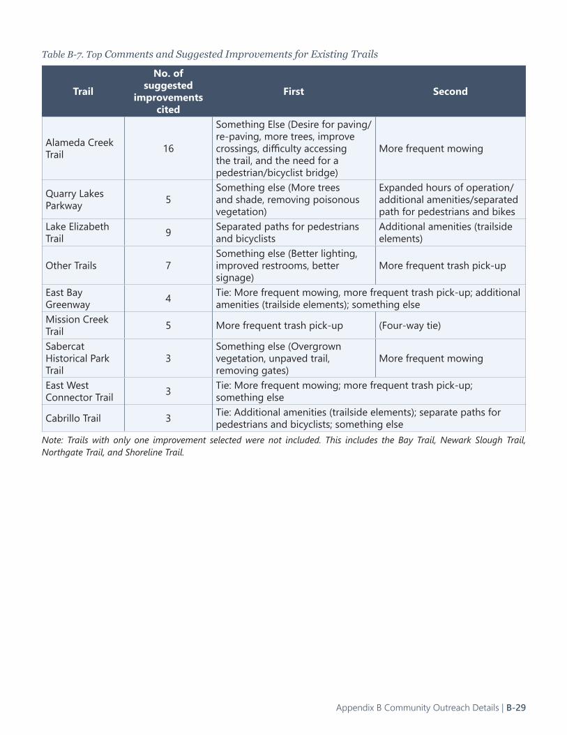
Table B-7. Top Comments and Suggested Improvements for Existing Trails
Trail
No. of suggested
improvements cited
First Second
Alameda Creek Trail 16
Something Else (Desire for paving/re-paving, more trees, improve crossings, difficulty accessing the trail, and the need for a pedestrian/bicyclist bridge)
More frequent mowing
Quarry Lakes Parkway 5
Something else (More trees and shade, removing poisonous vegetation)
Expanded hours of operation/additional amenities/separated path for pedestrians and bikes
Lake Elizabeth Trail 9 Separated paths for pedestrians
and bicyclistsAdditional amenities (trailside elements)
Other Trails 7Something else (Better lighting, improved restrooms, better signage)
More frequent trash pick-up
East Bay Greenway 4 Tie: More frequent mowing, more frequent trash pick-up; additional
amenities (trailside elements); something elseMission Creek Trail 5 More frequent trash pick-up (Four-way tie)
Sabercat Historical Park Trail
3Something else (Overgrown vegetation, unpaved trail, removing gates)
More frequent mowing
East West Connector Trail 3 Tie: More frequent mowing; more frequent trash pick-up;
something else
Cabrillo Trail 3 Tie: Additional amenities (trailside elements); separate paths for pedestrians and bicyclists; something else
Note: Trails with only one improvement selected were not included. This includes the Bay Trail, Newark Slough Trail, Northgate Trail, and Shoreline Trail.
Appendix B Community Outreach Details | B-29
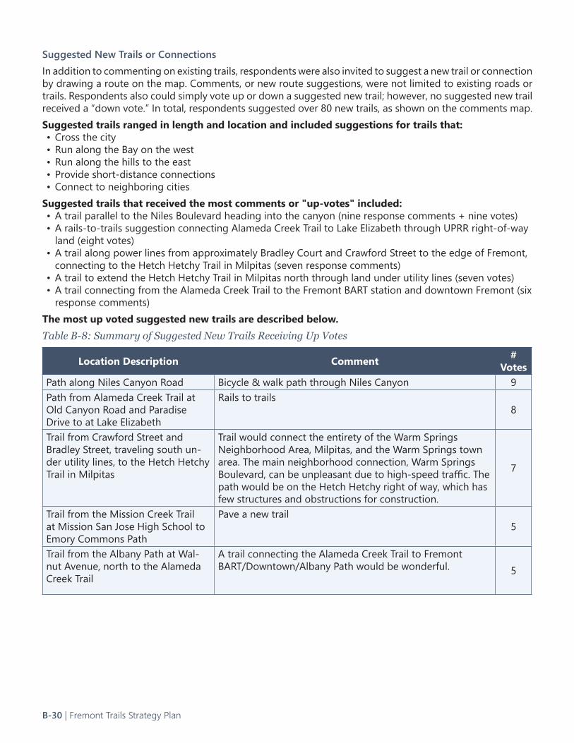
Suggested New Trails or ConnectionsIn addition to commenting on existing trails, respondents were also invited to suggest a new trail or connection by drawing a route on the map. Comments, or new route suggestions, were not limited to existing roads or trails. Respondents also could simply vote up or down a suggested new trail; however, no suggested new trail received a “down vote.” In total, respondents suggested over 80 new trails, as shown on the comments map.Suggested trails ranged in length and location and included suggestions for trails that: • Cross the city• Run along the Bay on the west• Run along the hills to the east• Provide short-distance connections• Connect to neighboring cities
Suggested trails that received the most comments or "up-votes" included:• A trail parallel to the Niles Boulevard heading into the canyon (nine response comments + nine votes)• A rails-to-trails suggestion connecting Alameda Creek Trail to Lake Elizabeth through UPRR right-of-way
land (eight votes) • A trail along power lines from approximately Bradley Court and Crawford Street to the edge of Fremont,
connecting to the Hetch Hetchy Trail in Milpitas (seven response comments)• A trail to extend the Hetch Hetchy Trail in Milpitas north through land under utility lines (seven votes)• A trail connecting from the Alameda Creek Trail to the Fremont BART station and downtown Fremont (six
response comments)The most up voted suggested new trails are described below. Table B-8: Summary of Suggested New Trails Receiving Up Votes
Location Description Comment # Votes
Path along Niles Canyon Road Bicycle & walk path through Niles Canyon 9Path from Alameda Creek Trail at Old Canyon Road and Paradise Drive to at Lake Elizabeth
Rails to trails8
Trail from Crawford Street and Bradley Street, traveling south un-der utility lines, to the Hetch Hetchy Trail in Milpitas
Trail would connect the entirety of the Warm Springs Neighborhood Area, Milpitas, and the Warm Springs town area. The main neighborhood connection, Warm Springs Boulevard, can be unpleasant due to high-speed traffic. The path would be on the Hetch Hetchy right of way, which has few structures and obstructions for construction.
7
Trail from the Mission Creek Trail at Mission San Jose High School to Emory Commons Path
Pave a new trail5
Trail from the Albany Path at Wal-nut Avenue, north to the Alameda Creek Trail
A trail connecting the Alameda Creek Trail to Fremont BART/Downtown/Albany Path would be wonderful. 5
B-30 | Fremont Trails Strategy Plan
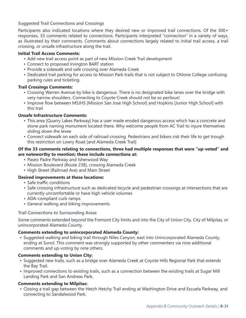
Suggested Trail Connections and CrossingsParticipants also indicated locations where they desired new or improved trail connections. Of the 300+ responses, 33 comments related to connections. Participants interpreted “connection” in a variety of ways, as illustrated by their comments. Comments about connections largely related to initial trail access, a trail crossing, or unsafe infrastructure along the trail. Initial Trail Access Comments:
• Add new trail access point as part of new Mission Creek Trail development• Connect to proposed Irvington BART station• Provide a sidewalk and safe crossing over Alameda Creek• Dedicated trail parking for access to Mission Park trails that is not subject to Ohlone College confusing
parking rules and ticketing.Trail Crossings Comments:
• Crossing Warren Avenue by bike is dangerous. There is no designated bike lanes over the bridge with very narrow shoulders. Connecting to Coyote Creek should not be so perilous!
• Improve flow between MSJHS [Mission San Jose High School] and Hopkins [Junior High School] with this trail
Unsafe Infrastructure Comments:• This area [Quarry Lakes Parkway] has a user made eroded dangerous access which has a concrete and
stone park naming monument located there. Why welcome people from AC Trail to injure themselves sliding down the levee
• Connect sidewalk on each side of railroad crossing. Pedestrians and bikers risk their life to get trough this restriction on Lowry Road [and Alameda Creek Trail]
Of the 33 comments relating to connections, three had multiple responses that were “up-voted” and are noteworthy to mention; these include connections at:
• Paseo Padre Parkway and Isherwood Way• Mission Boulevard (Route 238), crossing Alameda Creek• High Street (Railroad Ave) and Main Street
Desired improvements at these locations:• Safe traffic conditions• Safe crossing infrastructure such as dedicated bicycle and pedestrian crossings at intersections that are
currently uncomfortable or have high vehicle volumes• ADA-compliant curb ramps• General walking and biking improvements
Trail Connections to Surrounding AreasSome comments extended beyond the Fremont City limits and into the City of Union City, City of Milpitas, or unincorporated Alameda County.Comments extending to unincorporated Alameda County:• Suggested walking and biking trail through Niles Canyon, east into Unincorporated Alameda County,
ending at Sunol. This comment was strongly supported by other commenters via nine additional comments and up-voting by nine others.
Comments extending to Union City:• Suggested new trails, such as a bridge over Alameda Creek at Coyote Hills Regional Park that extends
the Bay Trail.• Improved connections to existing trails, such as a connection between the existing trails at Sugar Mill
Landing Park and San Andreas Park.Comments extending to Milpitas:• Closing a trail gap between the Hetch Hetchy Trail ending at Washington Drive and Escuela Parkway, and
connecting to Sandalwood Park.
Appendix B Community Outreach Details | B-31
Location-Specific Trail Improvement Comments (Survey and Map)The list below includes all the online survey comments that were location-specific. These are grouped by existing and proposed trail corridors. The number of people who mentioned each location-specific trail improvement is shown in parentheses (#). The second number represents the number of interactive map comments received (#+#).
Alameda Creek Trail• Improve Crossings:
• Improve all underpasses/crossings (13)• Mission Boulevard & ACT (2)
• Add Connections:• To Mission Boulevard (near Mowry Ave) (5)• To Central Fremont hub & commercial district (3+5)• To Fremont BART Station (a pedestrian/bike bridge or a separated bike lane on Fremont Boulevard
South) (2)• To Vallejo Mill School through Amtrak Rail Line (3)• To Ardenwood Park & Ride and Ardenwood Historic Farm (2)• To Lowry Road (1)• To WHHS and Kaiser (1)• To Centerville Station (1)• To Parkmont neighborhood (1)• From I-880 & Decoto Rd using the land along I-880 to access to the ACT (1)
• Repave or Pave:• Southside of ACT (5)• From Isherwood Way to Mission Boulevard (4)• West of Isherwood (2)• Informal trail access points (2)• Use soft materials on shoulders, not sharp rocks/boulders (2)• Pave Northside of ACT (1)• New gravel needed on the Northside of ACT (1)• Southside from the Beard Road Staging Area to Niles Canyon (1)
• Build Bridges:• Beard Road Staging Area to Northside of ACT (1)• Between the Mission Boulevard Bridge and Sequoia Terrace Bridge (1) • From the Northside of ACT to access Coyote Hills (1)
Niles Canyon Trail • Add Connections:
• Start at Vallejo Mills Historical Park and at the East end of Old Niles Canyon Road (1)• Start at the abandoned RR by Morrison Canyon Road (1)
San Francisco Bay Trail • Improve Crossings:
• Fremont Boulevard & Cushing Parkway (2)• RR crossing near Boyce Rd. & Stewart Ave (1)• Ardenwood Blvd Crossings (1)• Add a stoplight at the Paseo Padre Parkway & the Coyote Hills Entrance (1)
• Add Connections:• Reopen and pave the Shoreline Trail & Marshlands Rd connection (2)• To Bay Area Ridge Trail (1)• Off-street trail from Dumbarton Bridge to South Fremont (1)
• Repave or Pave:• From the Dumbarton Bridge overpass to the Coyote Hills Loop (1)
B-32 | Fremont Trails Strategy Plan
• Re-Route or Improve Segments: • From Dumbarton Bridge Toll Plaza to Quarry Road (2)• Build a trail following SR-84 for bikes as an alternate route to the start of the ACT along Lowry Rd (1)• Biking along Dumbarton Bridge to Thornton Ave, Cherry Ave, Boyce Ave, Cushing Parkway, and
Fremont Blvd to connect with the Bay Trail in the wetlands near Warren Ave is dangerous (1)• Cushing Parkway & Fremont Blvd to Auto Mall Parkway (1)• Formalize Coyote Creek Lagoon Trail behind the USD plant by Warren to avoid Fremont Boulevard (1)• Connect Boyce Road to Cherry Street to Fremont Boulevard (1) • Alternative Route Proposal: Willow to Plummer Creek to land bridge to Don Edwards and the Mowry
Slough then moving inland towards Auto Mall Parkway (1)
East Bay Greenway• Add Connections:
• Along Osgood Road Bart Tracks to Fremont Warm Springs Bart Station and Milpitas (5)• To Paseo Padre Southbound bike lane (build a staircase or ramp) (2)• Warm Spring Trail and Connections (2+8)• To the Tesla factory (2)• To Union City BART (1)• From Orchard Ave (1)
• Requires Landscaping:• Plant trees from Union St. to Central Park (1)
Dumbarton Bridge to Quarry Lakes Trail • Add Crossings:
• I-880 & Decoto Road (10+6)• Add Connections:
• Across Dumbarton Bridge (3)• To Alameda Creek Trail (2)• To Lake Elizabeth (1)• To Mission San Jose (1)• To Milpitas (1)
• Repave or Pave:• Marshlands Road (2)
Mission Creek Trail • Improve Crossings:
• Create a safer, aligned crossing at Driscoll Road with the trail (2)• Palm Ave & Via San Miguel (1)
• Add Connections:• From the East Bay Greenway & Mission Creek Trail across Stevenson Blvd to Mission Blvd (13)• Extend the trail beyond Palm Ave towards the I-680 freeway to close the gap (8+5)• Connect to Camino Santa Barbara instead of Palm Ave (1)
• Build Bridges:• Connect the two sides of Mission Creek (1)
• Repave or Pave:• The entire trail (2)
• Unlock Gates:• Los Pinos St (1)
• Requires Landscaping: (2)• Trim the bushes in front of Hopkins Junior High School and Mission San Jose High School along the
Creek• Distribute the mounds of wood chip mulch front of MSJ
Appendix B Community Outreach Details | B-33

• Remove the tall Eucalyptus trees that have been cut down (this is a fire hazard near Fremont schools and neighborhoods)
• Tree and brush trimming fire hazard at Covington Dr. & Mission Creek
Sabercat Historical Park Trail • Add Connections:
• To Irvington BART (build a bridge) (4)• Create a loop from East Bay Greenway Trail to Mission Creek Trail to Sabercat Trail and back to
Irvington BART station (2)• Create a loop from Antelope Hills, back to Pine Street and Old Mission Park (1)
• Requires Landscaping:• Trim bushes to allow for social distancing and greater visibility (1)
Hetch Hetchy North-South• Add Connections:
• Southern Segments from Milpitas to I-680 (6+7)• Close the gaps between Warren Ave and Scott Creek Road (3)• Close the gaps to avoid Dixon Road (1)• To Warm Springs Area (1)• To the Hetch Hetchy Trail in Milpitas (1)
• Add Amenities:• Add better lighting on Plomosa Park (add some ped level lighting along the section between Wilaneta
Ave and Merlot Drive) (1)
Hetch Hetchy East-West• Add Connections:
• To Ardenwood (1) • To Newark (1)
Cabrillo Park Trails • Add benches for seniors at park entry points and within the park (1)• Add overcrossings at Paseo Padre Parkway & Isherwood Way (1)
Northgate Trail • Improve Crossings:
• Paseo Padre Parkway & Whitehead Lane near Northgate Trail Entrance to create safe routes to school (2)
• Repave or Pave:• Widen pathways (1)
• Requires Landscaping:• Remove Northgate Central Park debris, trash, and tall grasses near Paseo Padre Parkway and plant
trees along the trail (1)
Central Park Loop Trail• Add Connections:
• RR from Lake Elizabeth to Niles Crest and Niles Canyon (4)• To Alameda Creek Trail (3)• To Mission/Ohlone (1)
• Repave or Pave:• New pavement markings indicating the flow of traffic on Central Park trails (1)• Widen the trails and add dedicated bike lanes (1)
• Requires Animal Control and Regular Cleaning:• Discourage the feeding of wildlife and keep the sidewalks at Central Park free of geese droppings (3)
B-34 | Fremont Trails Strategy Plan
Crandall Creek Trail & Ardenwood Path• Unlock Gates:
• Open Yukon Court Entrance (1)
U-Channel Trail• Unlock Gates:
• Greenbelt from Central Park to Mowry East Shopping Center (1)
PG&E Corridor & Channel Trail• Unlock Gates:
• Doane St (1)
Morrison Canyon Road• Improve Intersections:
• Sheridan Road & Mission Blvd (1)• Add Connections:
• Create a pathway along Morrison Canyon Road to access Vargas Plateau (6+6)• Connect Mission Peak to Vargas Plateau and Vargas Plateau to Niles Canyon (5)• To Central Park (3)• Work with EBRPD to connect Vargas Plateau to Mission Peak and Ohlone via Vargas Road (3)• Open a trail between the end of Canyon Heights Drive (presently there is a gate) and Morrison Canyon
Road (2)
Highways and Streets • I-880 Crossings:
• I-880 & Fremont Blvd (8+6)• I-880 & Dixon Landing Road (4)• I-880 & Warren Ave (3)• Build a pedestrian and bicycle bridge near Scott Creek Road & Kato Road (1)• New crossing at I-880 in South Fremont, the Warm Springs Area, allowing for easier access to the
Highway 237 bikeway (1)• I-680 Crossings:
• I-680 & Auto Mall Parkway (1)• I-680 & Vargas Road (1)
• Enhance Connectivity• Warm Springs neighborhood (3)• Connect Plomosa Neighborhood Park, Lone Tree Neighborhood Park, Booster Neighborhood Park, and
Warm Springs Community Park (2)• Parkmont Drive (and neighborhood) (1)• Mowry Ave & Peralta Blvd (1)• Brookvale neighborhood (1)• Warm Springs to central Fremont (1)• Mission Neighborhood (1)• Irvington Neighborhood (1)• Connect Ardenwood to Central Fremont (1) • Create protected two-way bike lane along Palm Ave from Mission Blvd to Washington Blvd (1)• Bay Area Ridge Trail (1)
• Redesign Streets for Bike/Ped Safety: • Fremont Blvd (6)• Mowry Ave (4)• Mission Blvd (and repave) (3)• Cherry St (2)• Boyce Rd (2)
Appendix B Community Outreach Details | B-35

• Add protected bike lanes, using physical separation such as curbs or movable concrete safety barriers, called K-rails by Caltrans (2)
• Warren Ave (1)• Stevenson Blvd (1)• Peralta Blvd between Paseo Padre Parkway and Fremont Blvd (1)• Decoto Road Eastbound (1)• Albrea St (1)• Mission Rd & Andrade Rd (Sunol) to Niles Canyon Rd, Paloma Way, Calaveras Rd. (Sunol) (1)• Decoto Road & 11st to Osprey Drive & Quarry Lakes Drive (1)• Remove a lanes from Fremont roads and dedicate them to pedestrians and bicyclists (1)
• Bike Lanes End Abruptly:• Blacow Rd (or Cherry St in Newark), Improve Safety (1)• Railroad Ave. to Paseo Padre Parkway (South) (1)
• More parking needed at the following locations:• Morrison Canyon Staging Area (1)• Mission Peak at Stanford Staging Area (1)• Mission Peak at Ohlone College (1)• End of Auto Mall Parkway (1)• Coyote Hills at Paseo Padre Parkway (large potholes at dirt lot) (1)
• East Bay Regional Park District Trails• Fremont neighborhood trail access to EBRPD trails (major parks: Coyote Hills Regional Park, Alameda
Creek Trail, Quarry Lakes, Mission Peak Regional Preserve, Vargas Plateau Regional Park, and others (1)• Build a trail from Vallejo Mill Historical Park to Dry Creek Pioneer Regional Park (1)
Specific Comments about Parks and Streets• Niles Community Park
• Requires Landscaping (1)• The park does not feel safe (1)
• Plants/trees/shrubs block views and create hiding places• Homeless often camp in this park• Graffiti tags make visitors uneasy
• Azevada Park• Build trails and improve drainage in Azevada Park. This park has no trails but is used as a shortcut for
Mowry Ave and Blacow Road and for kids going to Kennedy High School (1)• Paseo Padre Parkway
• Create safe entry and access points. Redesign for safety. High curbs, a lack of ramps, confusing crossings to go South, and a lack of separation from vehicles make this road dangerous (4)
• Widen Sidewalks (1)• Walnut Avenue Bikeway
• Add signage in multiple languages (1)• Blue Fin Way Pedway 28 Palms
• End Neighborhood Encroachment & Storage Shed/Junkyard (1)• Truman Place & Blue Fin Way
• Reopen the pedestrian connection (1)• Close Streets for People Walking and Biking
• Develop a Fremont Slow Streets Network (1)• Mission Lakes Neighborhood
• Repave the perimeter trail (1)
B-36 | Fremont Trails Strategy Plan
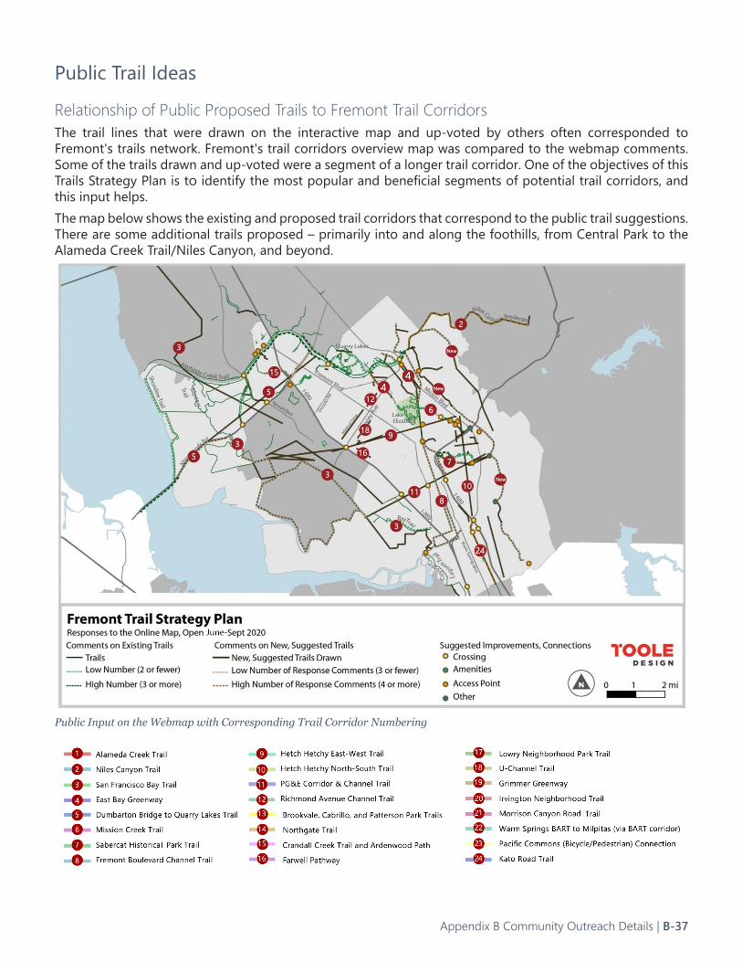
Public Trail Ideas
Relationship of Public Proposed Trails to Fremont Trail CorridorsThe trail lines that were drawn on the interactive map and up-voted by others often corresponded to Fremont's trails network. Fremont's trail corridors overview map was compared to the webmap comments. Some of the trails drawn and up-voted were a segment of a longer trail corridor. One of the objectives of this Trails Strategy Plan is to identify the most popular and beneficial segments of potential trail corridors, and this input helps.The map below shows the existing and proposed trail corridors that correspond to the public trail suggestions. There are some additional trails proposed – primarily into and along the foothills, from Central Park to the Alameda Creek Trail/Niles Canyon, and beyond.
Public Input on the Webmap with Corresponding Trail Corridor Numbering
Appendix B Community Outreach Details | B-37
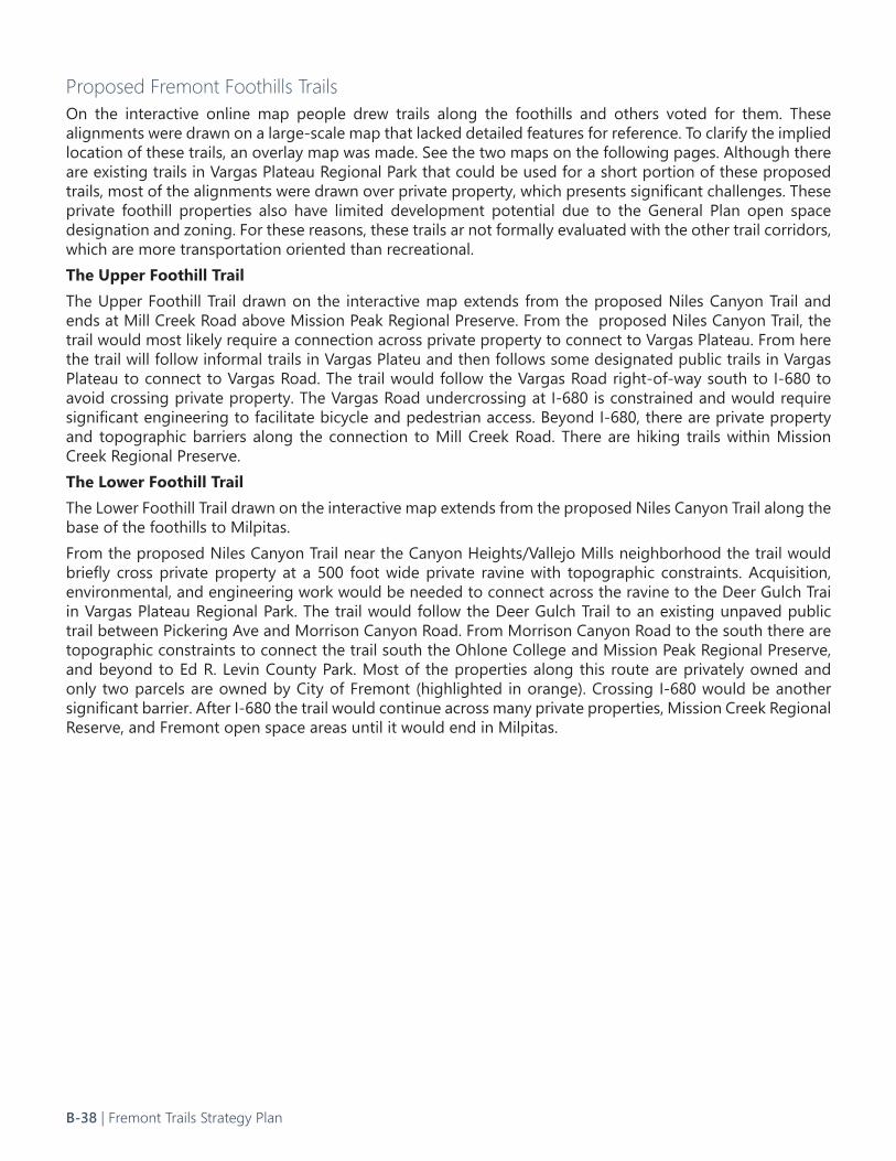
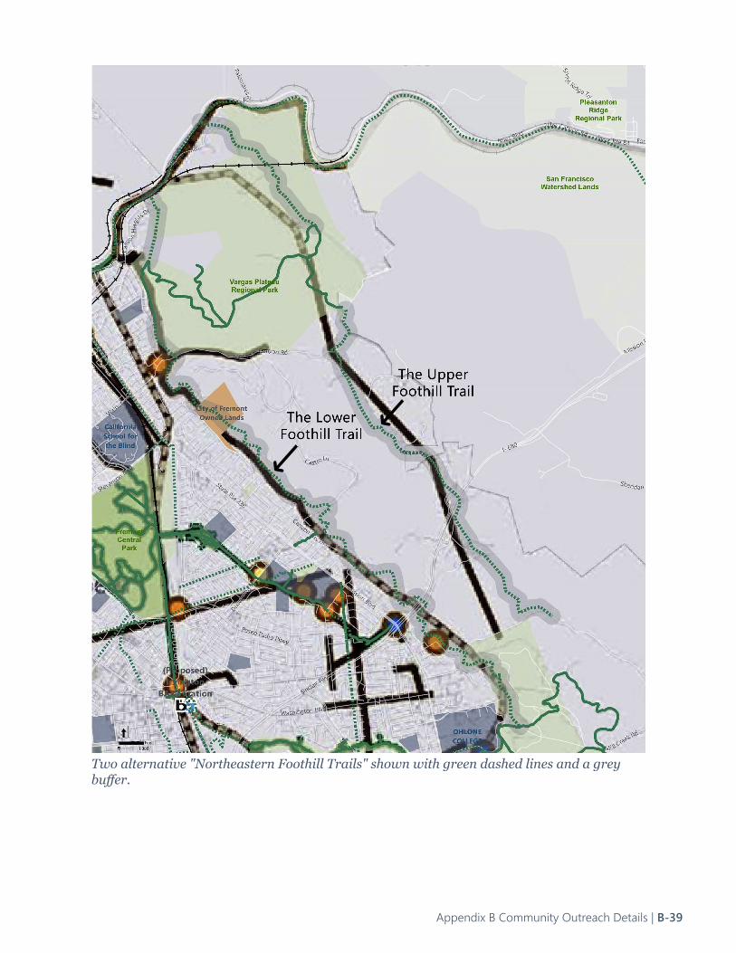
Proposed Fremont Foothills TrailsOn the interactive online map people drew trails along the foothills and others voted for them. These alignments were drawn on a large-scale map that lacked detailed features for reference. To clarify the implied location of these trails, an overlay map was made. See the two maps on the following pages. Although there are existing trails in Vargas Plateau Regional Park that could be used for a short portion of these proposed trails, most of the alignments were drawn over private property, which presents significant challenges. These private foothill properties also have limited development potential due to the General Plan open space designation and zoning. For these reasons, these trails ar not formally evaluated with the other trail corridors, which are more transportation oriented than recreational. The Upper Foothill Trail The Upper Foothill Trail drawn on the interactive map extends from the proposed Niles Canyon Trail and ends at Mill Creek Road above Mission Peak Regional Preserve. From the proposed Niles Canyon Trail, the trail would most likely require a connection across private property to connect to Vargas Plateau. From here the trail will follow informal trails in Vargas Plateu and then follows some designated public trails in Vargas Plateau to connect to Vargas Road. The trail would follow the Vargas Road right-of-way south to I-680 to avoid crossing private property. The Vargas Road undercrossing at I-680 is constrained and would require significant engineering to facilitate bicycle and pedestrian access. Beyond I-680, there are private property and topographic barriers along the connection to Mill Creek Road. There are hiking trails within Mission Creek Regional Preserve. The Lower Foothill TrailThe Lower Foothill Trail drawn on the interactive map extends from the proposed Niles Canyon Trail along the base of the foothills to Milpitas. From the proposed Niles Canyon Trail near the Canyon Heights/Vallejo Mills neighborhood the trail would briefly cross private property at a 500 foot wide private ravine with topographic constraints. Acquisition, environmental, and engineering work would be needed to connect across the ravine to the Deer Gulch Trai in Vargas Plateau Regional Park. The trail would follow the Deer Gulch Trail to an existing unpaved public trail between Pickering Ave and Morrison Canyon Road. From Morrison Canyon Road to the south there are topographic constraints to connect the trail south the Ohlone College and Mission Peak Regional Preserve, and beyond to Ed R. Levin County Park. Most of the properties along this route are privately owned and only two parcels are owned by City of Fremont (highlighted in orange). Crossing I-680 would be another significant barrier. After I-680 the trail would continue across many private properties, Mission Creek Regional Reserve, and Fremont open space areas until it would end in Milpitas.
B-38 | Fremont Trails Strategy Plan
Two alternative "Northeastern Foothill Trails" shown with green dashed lines and a grey buffer.
Appendix B Community Outreach Details | B-39
The "Southwestern Foothill Trail" extending south from Ohlone College to Milpitas
B-40 | Fremont Trails Strategy Plan
Proposed Alameda Creek Trail to Central Park ConnectionFour lines were drawn on the interactive map connecting the Alameda Creek Trail (ACT) to Fremont Central Park. The proposed alignments from interactive map are shown on the following page. The First AlignmentThe first alignment utilizes the abandoned Union Pacific Railroad (UPRR) from the Alameda Creek Trail to the east side of the golf course in Central Park. This alignment was also mentioned in the online survey. The City of Fremont determined that this alignment was infeasible after the completion of the UPRR Rails-to-Trails Feasibility Study. This alignment is not being considered in the Trails Strategy Plan.The Second AlignmentThe second alignment begins at the Alameda Creek Trail then continues along Mission Boulevard to Central Park. This alignment is described in the Trails Strategy Plan as East Bay Greenway Reach 2 Alternative 2.The Third AlignmentThe third alignment begins at the Alameda Creek Trail, following the active Union Pacific Railroad (UPRR) to Central Park. This alignment was also mentioned in the online survey. This alignment is not being considered in the Trails Strategy Plan.The Fourth AlignmentThe fourth alignment would use Guardino Drive to connect the Alameda Creek Trail to Central Park. The Bicycle Master Plan (BMP) proposes adding buffered bike lanes along Guardino Drive.
Appendix B Community Outreach Details | B-41
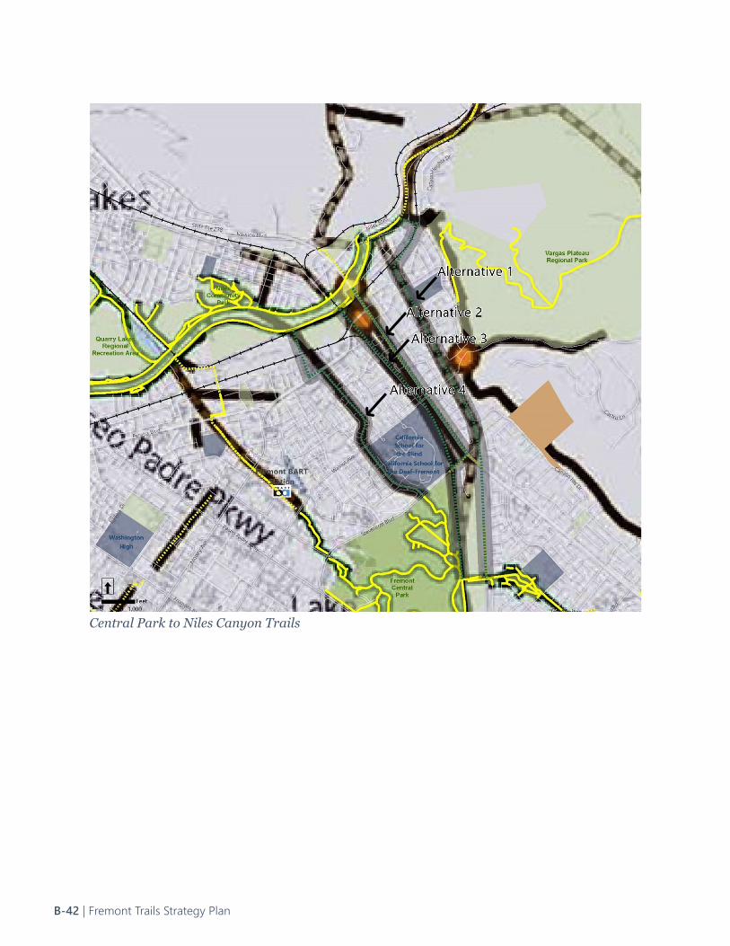
Central Park to Niles Canyon Trails
B-42 | Fremont Trails Strategy Plan
Community EmailsCity of Fremont received 13 emails from community members between August of 2020 and April of 2021. Most of these emails come from regular trail users and recommended improvements for specific trails. These recommendations are documented and summarized below.From: Arun (August 28, 2020)• Sabercat Historical Park Trail: Shelters and seats at intervals for rest and protection against sun, rain, and
wind• Sabercat Historical Park Trail: One or two rest rooms for the entire length of trail• Sabercat Historical Park Trail: Widening and repaving in some portions for a smooth walk or run
From: Reza (August 31, 2020)• Sabercat Historical Park Trail: Adding light amenities for evening walk.
From: Jeneva (August 29, 2020)• Support Fremont Trails Strategy Plan and Fremont Bicycle Master Plan.
From: Harlon (September 1, 2020)• Mission Creek Trail: Complete the unimproved section between Palm Avenue and northwest of I-680/
Mission Boulevard interchangeFrom: Gerald (September 23, 2020)• Hetch-Hetchy East-West Trail: Current Azeveda Park does not have any formally improved trails, while
students at Kennedy High School use it as a short cut to school. In addition, the Azeveda Park has some drainage issue during rainy season. Gerald recommended that formal trails to be added to Azeveda Park.
From: Steve (October 2, 2020)• General comments (not location specific): City should collect public comments regarding identifying
types of trails. From: Olga and Louis (October 21, 2020)• Alameda Creek Trail: The community member expressed their concern for safety issues. They mentioned
that they stopped walking the Alameda Creek Trail between Isherwood Drive and Dominici Drive because of the presence of needles litter, unleashed dogs, and homeless people walking with a machette.
From: Jim (November 3, 2020)• Connection to Morrison Canyon Road: make a connection to Morrison Canyon Road from Canyon
Heights Drive via the former rail line.
Appendix B Community Outreach Details | B-43
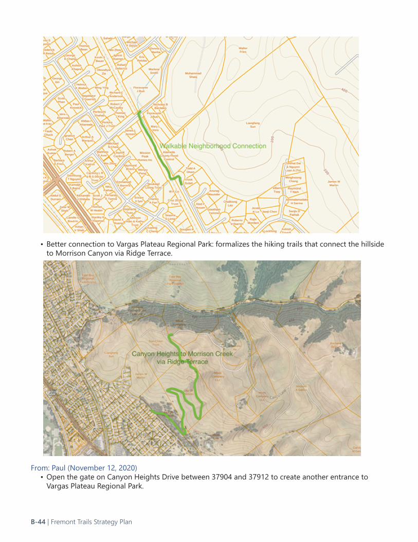
• Better connection to Vargas Plateau Regional Park: formalizes the hiking trails that connect the hillside to Morrison Canyon via Ridge Terrace.
From: Paul (November 12, 2020)• Open the gate on Canyon Heights Drive between 37904 and 37912 to create another entrance to
Vargas Plateau Regional Park.
B-44 | Fremont Trails Strategy Plan
From: Christina (November 16, 2020)• Fremont Central Park: Make it mandatory to wear face mask and practice social distancing. Make the
Lake Elizabeth Lake trail one way to avoid overcrowding during Covid-19 Pandemic.• Fremont Central Park: Keep dogs on leash. Consider restricting bicyclists on Lake Elizabeth Look Trail. Put
more warning signs of “do not feed ducks, cats, and birds."From: Leila (December 27, 2020)• East Bay Greenway: Recommend that unused train tracks could be converted to a paved walking and
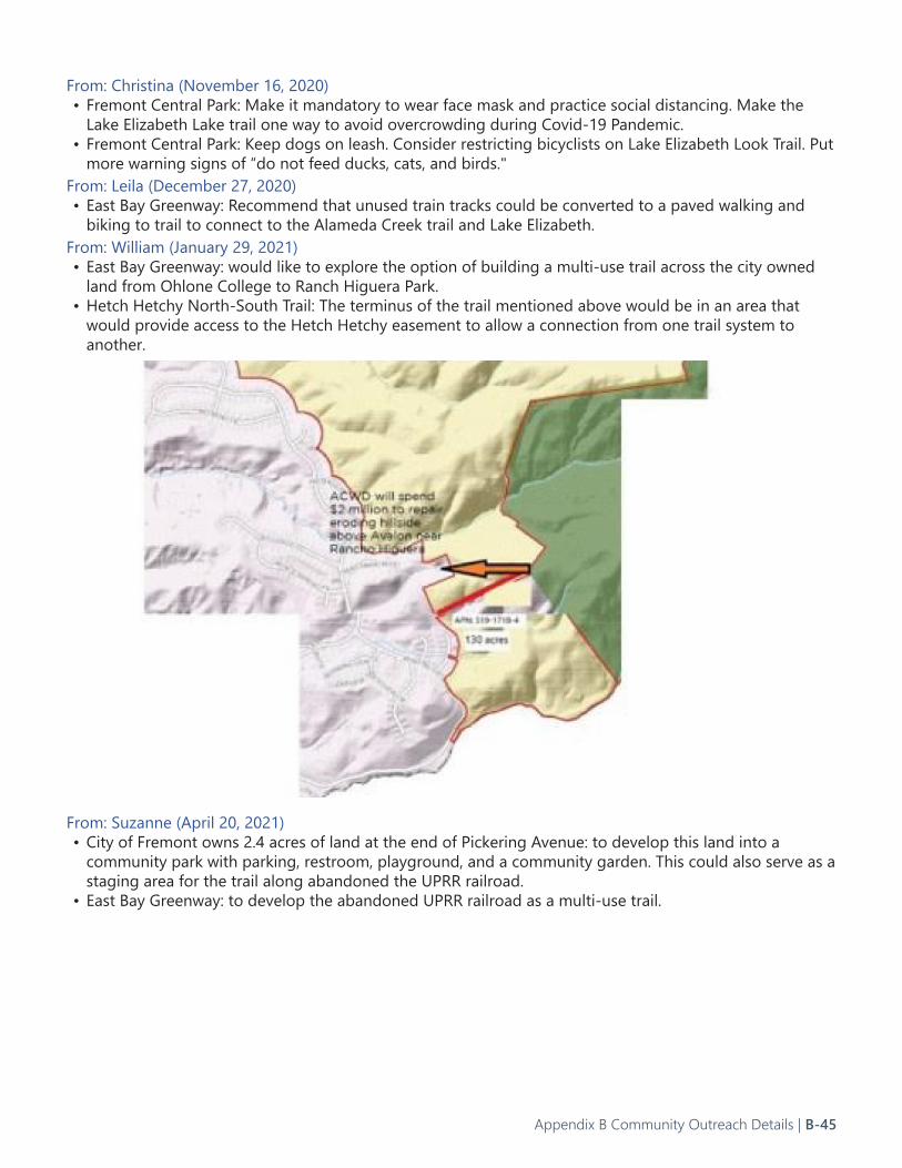
biking to trail to connect to the Alameda Creek trail and Lake Elizabeth.From: William (January 29, 2021)• East Bay Greenway: would like to explore the option of building a multi-use trail across the city owned
land from Ohlone College to Ranch Higuera Park. • Hetch Hetchy North-South Trail: The terminus of the trail mentioned above would be in an area that
would provide access to the Hetch Hetchy easement to allow a connection from one trail system to another.
From: Suzanne (April 20, 2021)• City of Fremont owns 2.4 acres of land at the end of Pickering Avenue: to develop this land into a
community park with parking, restroom, playground, and a community garden. This could also serve as a staging area for the trail along abandoned the UPRR railroad.
• East Bay Greenway: to develop the abandoned UPRR railroad as a multi-use trail.
Appendix B Community Outreach Details | B-45
value parks and trails: “Given the recent COVID-19/Coronavirus pandemic, how has your and your household's perception of the value of parks, trails, open spaces, and recreation changed?”
• 37% say the value has significantly increased, • 22% say the value has somewhat increased, • 25% say no change, • 5% say the value has somewhat decreased, • 6% say the value has significantly decreased, &• 6% did not provide a response.
The pandemic has inspired a heightened appreciation for parks, trails, open spaces, and recreation as well as an increased use of parks. Question 1 states, “Have you or any member of your household visited any parks or facilities offered by the City of Fremont during the last 2 years?”
• 97% of respondents said yes, compared to the national average of 79%.
Below is a summary of question responses directly related to trails and trailside elements:Question 1c. states: “If your household has NOT visited any City of Fremont parks/facilities during the last 2 years, please CHECK ALL of the following reasons you have NOT visited, before the COVID-19 Pandemic.” The top responses are:
• Lack of parking to access parks/trails (44%), • Not aware of parks' or trails' locations (39%), • Do not feel safe using parks/trails (33%) • Lack of restrooms (33%)
Although “do not feel safe using parks/trails” is too vague to offer a concrete solution, inadequate park or trail access (lack of parking), inadequate wayfinding, signage, and maps, and inadequate restrooms are significant deterrents to visiting Fremont’s parks. Question 4, “Most Preferred Methods of Communication For Information About
The following is a summary of the City of Fremont Parks and Recreation Needs Assessment as it directly relates to Fremont’s Trails Strategy Plan. The needs assessment was prepared by ETC Institute, a national firm that conducts community, organizational, and transportation surveys. In 2020, ETC Institute mailed a survey packet to a random sample of households in Fremont. The survey results will be used to help determine priorities for parks, recreation facilities, program offerings, special event offerings, and planning in Fremont. Since the parks needs assessment survey also addresses trails and trailside elements/amenities, the survey also provides important public input for the Trails Strategy Plan. The statistically valid survey received 527 responses, resulting in a precision of at least +/-4.2% at the 95% level of confidence. The survey respondents mirrored the demographics of Fremont’s residents. 50.4% of respondents were male, 49.4% female, and 0.7% non-binary. 20% of respondents were 18-34 years old, 19% were 35-44 years, 21% were 45-54 years, 20% were 55-64 years, and 21% were 65+ years. There was a wide range in the number of years respondents have lived in Fremont. 58% identified as Asian, 25% as White/Caucasian, 13% as Hispanic/Latino, 3% as African American/Black, 2% as Native American, and 1% as other. With this diverse array of ages, demographics, and years of residency in Fremont, and with the demographic breakdown of the survey respondents mirroring the census data for Fremont, the survey findings carry a lot of weight. The breakdown of responses for each question can also be scaled to the community’s actual size, unlike an online survey open to anyone regardless of their place of residence where the results can be skewed by a vocal interest group. This survey was conducted during the global Coronavirus pandemic. Question 18 speaks to the effect of the pandemic on how Fremont residents
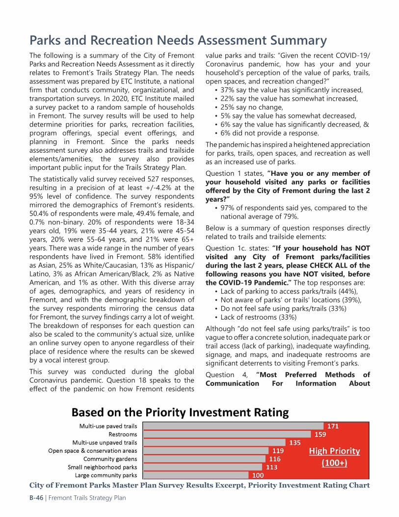
City of Fremont Parks Master Plan Survey Results Excerpt, Priority Investment Rating Chart
Parks and Recreation Needs Assessment Summary
B-46 | Fremont Trails Strategy Plan
Recreation Programs and Activities” affirms the importance of the City recreation guide, email/eblasts from City, the City website, and the Quarterly City newsletter as a news source. It is critical that the City provides detailed trail network maps and trail network updates on these preferred communication channels. Question 7, “Households’ Facility/Amenity Needs,” first reports the percentage of respondents who expressed a need for certain facilities/amenities. The respondents could select multiple facilities/amenities. The top 5 most needed facilities/amenities all relate to the Fremont Trails Strategy plan:
• 73% of respondents’ households need multi-use "paved" trails
• 73% need restrooms • 62% need large community parks• 61% need multi-use "unpaved" trails • 60% need open & conservation areas
Once the community facility needs were documented, Question 7 proceeds to assess “How Well Facility/Amenity Needs Are Being Met.” For multi-use “paved” trails:
• 27% of respondents reported their need was 100% met
• 30% said their need was 75% met • 30% said their need was 50% met, • 12% said their need was 25% met• 2% said their need was 0% met
The needs of the survey respondents as a whole were less met for facility/amenity multi-use “unpaved” trails:
• 25% of respondents’ needs were 100% met• 27% said their need was 75% met• 30% said their need was 50% met• 13% said their need was 25% met• 6% their need was 0% met
Extrapolating the number of Fremont households whose facility/amenity needs are 50% or less met by the existing conditions, for multi-use paved trails, the estimate is 26,011 households based on an estimated 81,652 households. 32% of Fremont households need for multi-use paved trails are 50% or less met
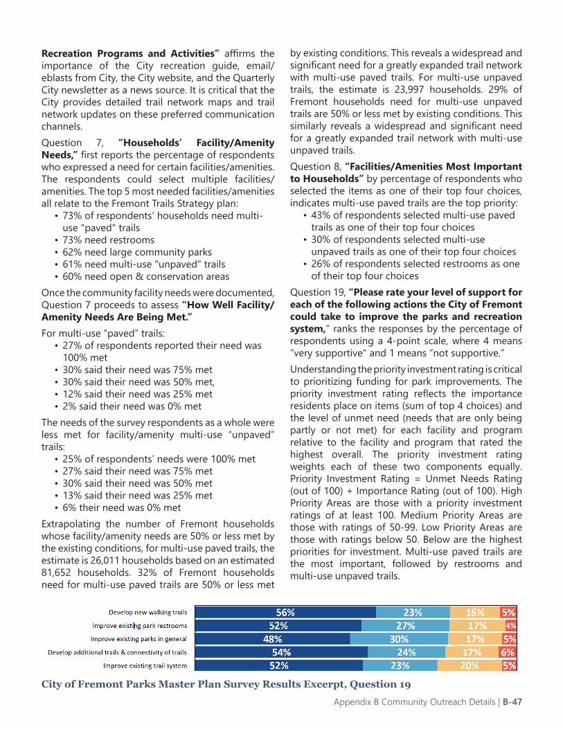
City of Fremont Parks Master Plan Survey Results Excerpt, Question 19
by existing conditions. This reveals a widespread and significant need for a greatly expanded trail network with multi-use paved trails. For multi-use unpaved trails, the estimate is 23,997 households. 29% of Fremont households need for multi-use unpaved trails are 50% or less met by existing conditions. This similarly reveals a widespread and significant need for a greatly expanded trail network with multi-use unpaved trails. Question 8, “Facilities/Amenities Most Important to Households” by percentage of respondents who selected the items as one of their top four choices, indicates multi-use paved trails are the top priority:
• 43% of respondents selected multi-use paved trails as one of their top four choices
• 30% of respondents selected multi-use unpaved trails as one of their top four choices
• 26% of respondents selected restrooms as one of their top four choices
Question 19, “Please rate your level of support for each of the following actions the City of Fremont could take to improve the parks and recreation system,” ranks the responses by the percentage of respondents using a 4-point scale, where 4 means “very supportive" and 1 means “not supportive.”Understanding the priority investment rating is critical to prioritizing funding for park improvements. The priority investment rating reflects the importance residents place on items (sum of top 4 choices) and the level of unmet need (needs that are only being partly or not met) for each facility and program relative to the facility and program that rated the highest overall. The priority investment rating weights each of these two components equally. Priority Investment Rating = Unmet Needs Rating (out of 100) + Importance Rating (out of 100). High Priority Areas are those with a priority investment ratings of at least 100. Medium Priority Areas are those with ratings of 50-99. Low Priority Areas are those with ratings below 50. Below are the highest priorities for investment. Multi-use paved trails are the most important, followed by restrooms and multi-use unpaved trails.
Appendix B Community Outreach Details | B-47