AIP AD 2.1-VQPR -1 BHUTAN 01-Mar-18 - doat.gov.bt Aerodromes - VQPR.pdf · 4 De-icing facilities...
16
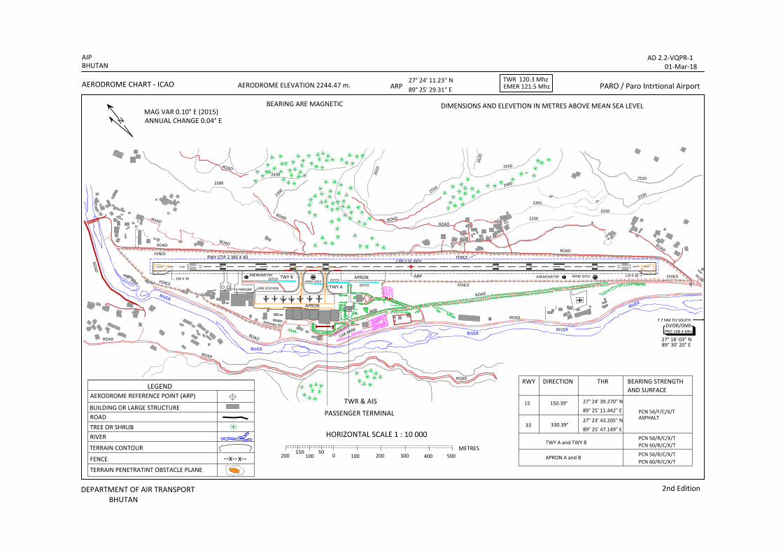
AIP AD 2.1-VQPR-1 BHUTAN 01-Mar-18 DEPARTMENT OF AIR TRANSPORT 2 nd Edition BHUTAN AD 2.1 AERODROMES VQPR AD 2.1 AERODROME LOCATION INDICATOR AND NAME VQPR - PARO/International VQPR AD 2.2 AERODROME GEOGRAPHICAL AND ADMINISTRATIVE DATA 1 ARP co-ordinates and site at AD 272411.23N 0892529.30E Centre of RWY 2 Direction and distance from(city) 48 Km SW from Thimphu 3 Elevation/Reference temperature 2 244.479M (7363.776ft) MSL/ 28C 4 MAG VAR/Annual changes 0.10˚ East changing by 0.04 ˚E 5 AD Administration, address, telephone, telefax, telex. AFS Department of Air Transport, Paro: Bhutan. Tel No.(975)-8- 271403,271751 Email: [email protected] 6 Type of traffic permitted (IFR/VFR) IFR in VMC is permitted due to high terrain 7 Remarks AD PPR VQPR AD 2.3 OPERATIONAL HOURS 1 AD Administration Available MON - FRI 0300 – 1100 (UTC) 2 Customs and immigration Available during sked operations 3 Health and sanitation Available during sked operation & as and when required 4 AIS Briefing Office Available during operations and MON - FRI 0300 – 1100 (UTC) 5 ATS Reporting Office Available during operations and MON - FRI 0300 – 1100 (UTC) 6 MET Briefing Office Available during operations and MON - FRI 0300 – 1100 (UTC) 7 ATS During Operational Hrs 8 Fuelling Available during sked operations 9 Handling Available during sked operations 10 Security 24 hours 11 De-icing Not available 12 Remarks Out side those hours, service available O/R. Request to be submitted to the AD 24hrs before intended operation. VQPR AD 2.4 HANDLING SERVICES AND FACILITIES 1 Cargo-handling facilities Available with airline operator, Druk-air 2 Fuel/oil types Aviation Turbine Fuel only – Jet A1 3 Fuelling facilities/capacity 1 truck, 9000 litres, 500ltrs/Sec. 4 De-icing facilities Manual by sweeping 5 Hanger space for visiting aircraft Limited, by prior arrangement with operator, Druk-air. 6 Repair facilities for visiting A/C Available by prior arrangement with operator, Druk-air. 7 Remarks NIL VQPR AD 2.5 PASSENGER FACILITIES 1 Hotels Near AD and in the city. 2 Restaurants At AD and in city. 3 Transportation Taxi from the AD to Thimphu 4 Medical facilities First aid at AD. Hospital in the Paro town 8 Km. 5 Bank and Post Office Bank & Post office at AD. Open within AD HR 6 Tourist Office Office in the city :Tel: 975 – 2- 323251,fax: 975-2- 323695 7 Remarks Nil VQPR AD 2.6 RESCUE AND FIRE FIGHTING SERVICES 1 AD category for fire fighting Within AD HR: CAT 6 2 Rescue equipment Rescue Tools with CFT 3 Capability for removal of disabled aircraft NIL 4 Remarks NIL
Transcript of AIP AD 2.1-VQPR -1 BHUTAN 01-Mar-18 - doat.gov.bt Aerodromes - VQPR.pdf · 4 De-icing facilities...

AIP AD 2.1-VQPR-1 BHUTAN 01-Mar-18
DEPARTMENT OF AIR TRANSPORT 2nd Edition BHUTAN
AD 2.1 AERODROMES VQPR AD 2.1 AERODROME LOCATION INDICATOR AND NAME
VQPR - PARO/International
VQPR AD 2.2 AERODROME GEOGRAPHICAL AND ADMINISTRATIVE DATA
1 ARP co-ordinates and site at AD 272411.23N 0892529.30E Centre of RWY 2 Direction and distance from(city) 48 Km SW from Thimphu 3 Elevation/Reference temperature 2 244.479M (7363.776ft) MSL/ 28C 4 MAG VAR/Annual changes 0.10˚ East changing by 0.04 ˚E 5 AD Administration, address, telephone, telefax,
telex. AFS Department of Air Transport, Paro: Bhutan. Tel No.(975)-8- 271403,271751 Email: [email protected]
6 Type of traffic permitted (IFR/VFR) IFR in VMC is permitted due to high terrain 7 Remarks AD PPR
VQPR AD 2.3 OPERATIONAL HOURS
1 AD Administration Available MON - FRI 0300 – 1100 (UTC) 2 Customs and immigration Available during sked operations 3 Health and sanitation Available during sked operation & as and when required 4 AIS Briefing Office Available during operations and MON - FRI 0300 – 1100 (UTC) 5 ATS Reporting Office Available during operations and MON - FRI 0300 – 1100 (UTC) 6 MET Briefing Office Available during operations and MON - FRI 0300 – 1100 (UTC) 7 ATS During Operational Hrs 8 Fuelling Available during sked operations 9 Handling Available during sked operations 10 Security 24 hours 11 De-icing Not available 12 Remarks Out side those hours, service available O/R. Request to be submitted to the AD
24hrs before intended operation.
VQPR AD 2.4 HANDLING SERVICES AND FACILITIES
1 Cargo-handling facilities Available with airline operator, Druk-air 2 Fuel/oil types Aviation Turbine Fuel only – Jet A1 3 Fuelling facilities/capacity 1 truck, 9000 litres, 500ltrs/Sec. 4 De-icing facilities Manual by sweeping 5 Hanger space for visiting aircraft Limited, by prior arrangement with operator, Druk-air. 6 Repair facilities for visiting A/C Available by prior arrangement with operator, Druk-air. 7 Remarks NIL
VQPR AD 2.5 PASSENGER FACILITIES
1 Hotels Near AD and in the city. 2 Restaurants At AD and in city. 3 Transportation Taxi from the AD to Thimphu 4 Medical facilities First aid at AD. Hospital in the Paro town 8 Km. 5 Bank and Post Office Bank & Post office at AD. Open within AD HR 6 Tourist Office Office in the city :Tel: 975 – 2- 323251,fax: 975-2- 323695 7 Remarks Nil
VQPR AD 2.6 RESCUE AND FIRE FIGHTING SERVICES
1 AD category for fire fighting Within AD HR: CAT 6 2 Rescue equipment Rescue Tools with CFT 3 Capability for removal of disabled
aircraft NIL
4 Remarks NIL

AD 2.1-VQPR-2 AIP 01-Mar-18 BHUTAN
2nd Edition DEPARTMENT OF AIR TRANSPORT BHUTAN
VQPR AD 2.7 SEASONAL AVAILABILITY - CLEARING 1 Type of clearing equipment Manually Sweeping 2 Clearance priorities 1. RWY 33/15 and associated TWY to Apron
3 Remarks Information on snow clearance published from November - April
through NOTAM . See also snow plan in section AD 1.2.2
VQPR AD 2.8 APRON, TAXIWAYS AND CHECK LOCATION DATA 1 Apron surface and strength 1. Apron A Surface : Concrete, Strength: PCN 56/R/C/X/T
2. Apron B Surface : Concrete, Strength: PCN 60/R/C/X/T 2 Taxiway width, surface and strength 1. Taxiway: A Width:15 M Surface: Concrete
Strength: PCN 56/R/C/X/T 2. Taxiway B Width: 18 M Surface: Concrete
Strength: PCN 60/R/C/X/T 3 ACL location and elevation Location: At Apron
Elevation: 2 243.69M 4 VOR checkpoints Point A – Taxiway A Holding Points
27°24’20.97N 089°25’20.84E DVOR 324.4° DME 7.7NM Point B – Threshold RWY15 27°24’39N 089°25’11E DVOR 325.1° DME 8.2NM
5 INS check points - 6 Remarks NIL
VQPR AD 2.9 SURFACE MOVEMENT GUIDANCE AND CONTROL SYSTEM AND MARKINGS
1 Use of aircraft stand ID signs, TWY guide lines and visual docking/parking guidance system of aircraft stands
Nose-in guidance at aircraft stand
2 RWY and TWY markings and LGT Markings Available 3 Stop bars Stop bars where appropriate. 4 Remarks NIL.
VQPR AD 2.10 AERODROME OBSTACLES
In approach/TKOF areas In Circling area ad at AD Remarks Obstacle type Elevation RWY/Area affected Markings/LGT Coordinates
Obstacle type Elevation Markings/LGT Coordinates
a b c a b RWY 15 SEE AD 2.3 VQPR -1 RWY33 SEE AD 2.3 VQPR -2
TO BE DEVELOPED
VQPR AD 2.11 METEOROLOGICAL INFORMATION PROVIDED
1 Associated MET Office Paro Airport 2 Hours of service
MET Office outside hours During Flight operations only
3 Office responsible for TAF preparation Periods validity
TO BE DEVELOPED
4 Type of landing forecast Interval of issuance
Current Weather half hourly during flight operations (in Plain Language)
5 Briefing/consultation provided Personal consultation During flight operation(on demand) 6 Flight documentation
Language (s) used TO BE DEVELOPED, English
7 Charts and other information available for briefing or consultation
TO BE DEVELOPED/ satellite images/significant WX chart/upper charts are downloaded and provided prior departure.
8 Supplementary equipment available for providing information
NIL
9 ATS unit provided with information Paro Control Tower 10 Additional information (limitation of service, etc.) Presently limited to providing METAR and local current
valley WX in plain language only during flight operations.

AIP AD 2.1-VQPR-3 BHUTAN 01-Mar-18
DEPARTMENT OF AIR TRANSPORT 2nd Edition BHUTAN
VQPR AD 2.12 RUNWAY PHYSICAL CHARACTERISTICS Designations RWY NR
TRUE & MA BRG
Dimensions of RWY (M)
Strength (PCN) and surface of RWY and SWY
THR coordinates
THR elevation and highest elevation of TDZ of precision APP RWY
1 2 3 4 5 6 15
33
150.38°
331.50°
2265 X 30 M
2265 X 30 M
PCN 56/F/C/X/T
272439.270N 0892511.442E 272343.205N 0892547.149E
2 243.759 M AMSL
2 227.812 M AMSL
Slope of RYW-SWY
SWY Dimensions (M)
CWY Dimensions (M)
Strip Dimensions (M)
OFZ
Remarks
7 8 9 10 11 12
0.81% 160M X 30M
120M X 30M
NIL
2385 M X 30 M
NIL End of RWY15 272443.785N 0892508.560E (2244.479 M) End of RWY33 272339.802N 0892549.306E (2226.805 M) RWY Turn pad available at the both end of RWY
VQPR AD 2.13 DECLARED DISTANCES
RWY Designator
TORA (M)
TODA (M)
ASDA (M)
LDA (M)
Remarks
1 2 3 4 5 6 15 33
2265 2265
2265 2265
2265 2265
2105 2145
NIL
VQPR AD 2.14 APPROACH RUNWAY LIGHTNING
RWY Designator
APCH LGT Type LEN INTST
THR LGT Colour WBAR
VASIS (MEHT) PAPI
TDZ, LGT LEN
RWY Centre Line LGT Length, spacing, Colour, INTST
RWY edge LGT
LEN, spacing colour INTST
RWY END LGT colour INTST
RWY END LGT Colour WBAR
Remarks
NIL
VQPR AD 2.15 OTHER LIGHTING, SECONDARY POWER SUPPLY
1 ABN/IBN location, characteristics and hours of operation
Not established
2 LDI location and LGT Anemometer location and LGT
LDI: 50 M NW and 700 M SW of ARP, unlighted Anemometer : 300 M from THR 15 and THR 33, unlighted
3 TWY edge and centre line lighting NIL 4 Secondary power supply/switch-over time Secondary power supply to all lighting at AD 500KVA
Switch-over time : 60 sec 5 Remarks NIL
VQPR AD 2.16 HELICOPTER LANDING AREA
1 Coordinates TLOF of THR of FATO TO BE DEVELOPED 2 TLOF and/or FATO elevation M/FT TO BE DEVELOPED 3 TLOF and FATO are dimensions, surface,
strength, marking TO BE DEVELOPED
4 True and MAG BRG of FATO TO BE DEVELOPED 5 Declared distance available TO BE DEVELOPED 6 APP and FATO lightning TO BE DEVELOPED 7 Remarks

AD 2.1-VQPR-4 AIP 01-Mar-18 BHUTAN
2nd Edition DEPARTMENT OF AIR TRANSPORT BHUTAN
VQPR AD 2.17 ATS AIRSPACE
1 Designation and lateral limits PARO CTR* 273222N 0892730E 271956N 0893516E 270159N 0893515E 270159N 0892606E 271522N 0892606E 272747N 0891819E 273222N 0892730E
2 Vertical limits 17 500 MSL 3 Airspace classification Class D* 4 ATS unit call signLanguage(s) PARO Tower English 5 Transition altitude 18 000 ft 6 Remarks Two ways communication
Clearance – ATC & ADC required * Proposed CTR for Paro AD
VQPR AD 2.18 ATS COMMUNICATION FACILITIES
Service
Designation
Callsign
Frequency
Hours of operation
Remarks TWR
RADIO
Paro Tower
Paro Radio
120.3 Mhz (EXTN) 120.3 Mhz (STBY) 121.5 EMER. Freq.
8921 Khz 13342 Khz
HO
HO
As per sked flight operations
-do-
VQPR AD 2.19 RADIO NAVIGATION AND LANDING AIDS
Type of aid, CAT
of ILS/MLS (forVOR/ILS/ML
S, give VAR)
ID
Frequency
Hours of operation
Site of
transmitting antenna
coordinates
Elevation of DME
transmitting antenna
Remarks
DVOR/DME
PRO
108.4 MHz
HO 7.7 NM south of aerodrome 271803N 0893020E
3 469M
DME Channel 21X

AIP AD 2.1-VQPR-5 BHUTAN 01-Mar-18
DEPARTMENT OF AIR TRANSPORT 2nd Edition BHUTAN
VQPR 2.20 LOCAL TRAFFIC REGULATIONS 1. Airport regulations 1.1 At Paro Airport a number of local regulations apply, in accordance with ICAO Annex 2,11,14 Doc. 4444. See
GEN 1.2. 1.2 Marshaller assistance can be requested. 1.3 When a local regulation is of importance for the safe operation of aircraft on the apron, the information will be
given to each aircraft by the TWR on VHF R/T. 2. Taxiing to and from stands. 2.1 Arriving aircraft will be allocated a stand number by the TWR 2.2 Assistance from the “FOLLOW ME” vehicle can be requested from the TWR. 2.3 Departing flights shall contact the TWR to obtain ATC and ADC clearance before commencing Pushback & Start
up. Request for ATC clearance may take place at the earliest 5 minutes prior to Pushback & start-up. Frequency 120.3Mhz is to be used. Departing aircraft shall obtain taxi instruction from Paro TWR on 120.3 Mhz.
3. Parking for small aircraft (General aviation) General aviation small aircraft shall be guided by marshallers to the parking area. 4. Parking area for helicopters The parking area for helicopters will always be guided by a marshaller on the stand or on R/T from TWR.
5. Apron Taxiing during winter conditions
“Follow me” vehicle can be provided on request.
6. Taxiing Limitations
No limitations
7. School and Training Technical test flight – use of runways
Subject to permission from tower 8 Helicopter traffic
8.1 Request ARO during the hours of service and, if possible, not later then 24 hrs before the flight is to be carried
out. 8.2 Any request for approval of traffic shall contain the following information: a) Owner/Operator
b) Type of helicopter, registration/call sign
c) Date, arrival time/departure time, destination(s).
8.3 Furthermore, other details relevant to the evaluation of the request shall be given as required. 9. Removal of disable aircraft from runways 9.1 When an aircraft is wrecked on a runway, it is the duty of the owner or user of such aircraft to have it removed
from the runway as quickly as possible. If a wrecked aircraft is not removed from the runway as quickly as possible by the owner or user, the aircraft will be removed by the DoAT at owner’s or user’s expense.
VQPR AD 2.21 NOISE ABATEMENT PROCEDURES
TO BE DEVELOPED
AD 2.1-VQPR-6 AIP 01-Mar-18 BHUTAN
2nd Edition DEPARTMENT OF AIR TRANSPORT BHUTAN
VQPR AD 2.22 FLIGHT PROCEDURES 1 General Flight within Paro air traffic circuit shall be in accordance with the Visual Meteorological Conditions (VMC).
a) Prior operating into Paro airport the pilot in- command should be briefed and visit the aerodrome
as an observer.
- or should Undertake instruction in a simulator approved by the authority for that purpose. - or Request guide pilot (navigator) from the Authorised Clearing Agent.
- Clearances on behalf of private airlines and for additional logistics can be arrange by the
Local Clearing Agent. For contact see GEN 1.1 para 7
Note:- Bhutan Air Services (BAS) is the authorized Clearing agent on behalf of Department of Air Transport responsible for coordinating and collecting document for onward submission to the DG BCAA for seeking approval of clearances for private aircraft/helicopter that fly to Bhutan. All fees and charges for Private flight operated at Paro Aerodrome are also collected by the Bhutan Air Service on Behalf of DoAT.
b) In order to avoid unnecessary delay while departing from Paro, relevant clearances (YANKEE
ALPHA NUMBER) from DGCA India and other relevant clearances from the respective authority must be obtained to over fly/transiting through the respective airspaces.
c) Specific date & time of arrival/departure or over flying/transiting should be clearly mentioned
while obtaining such clearances. d) Last minute change in flight plan could lead to DELAY OF FLIGHT TO OBTAIN NEW
ADC/FIC. Therefore, it is recommended that all flights are to adhere with planned flight plan or inform to ARO regarding the changes in flight plan at least one day prior. DoAT Bhutan shall not be responsible for the delay of flight.
e) Flight wishing to depart early morning from Paro (BTN 0000–0400 UTC), is recommended to file
the flight plan at least one day prior to departure from Paro to avoid delay in obtaining ADC/FIC from INDIA FIR/FIC.
f) Flight plan can be filed during operational hours or during office hours (03:00 – 10:00 UTC) at the
following address.
ARO, CONTROL TOWER, 1st FLOOR, PARO AIRPORT. Tel No. 975-8-272306/272895 Fax No. 975272307 Email:- [email protected] AFTN:- VQPRZPZX
2 Radar Procedures No Radar facilities are available at Paro Aerodrome. 3 Communication failure In the event of a communication failure, the pilot shall act in accordance with the communication failure
procedures in ICAO Annex 10 Vol. II and Annex 2 general rules para 3.6.52 4 Procedures for IFR flights with in Paro air traffic circuit Due to high terrain and steep mountains adjacent to the aerodrome, only flight in VMC is permitted.
AIP AD 2.1-VQPR-7 BHUTAN 01-Mar-18
DEPARTMENT OF AIR TRANSPORT 2nd Edition BHUTAN
5 Procedures for flights to/from Paro AD 5.1 ATC clearance for flights will be given under the conditions described below:
a) A flight plan containing items 7 to 18 and indicating the purpose of the flight, shall be submitted to Paro ATC.
b) ATC and ADC/FIC clearance number shall be obtained before the aircraft Taxi out. c) Position reports shall be submitted in accordance with 3.6.3 of ICAO Annex 2. d) Deviation from the ATC clearance may only be made when prior permission has been obtained. e) Two-ways radio communication shall be maintained on the frequency 120.3 MHz.
5.2 With the high terrain and rapid phenomenon change of weather in and around the Paro aerodrome, all
flights are operated in VMC, therefore any aircraft operating in Bhutanese territory are required to obtain weather information from Paro aerodrome at least one hour prior to departure.
5.3 Paro weather will available on HF Radio on freq. 8921Khz and 13342Khz, call sign Paro radio or can
be requested on AFTN i.e. On VQPRYMYX, VQPRZTZX, VQPRZPZX. 5.4 Arrival Instruction 5.4.1 Flight plan should be filed on AFTN/Fax prior one hour departure followed by status of flight, in the
event of any delay or cancellation of flight likely to occur. 5.4.2 Airborne call is must as soon as the aircraft departs from the departure aerodrome with the ATD and
ETA over Paro. Airborne time & ETA should be informed to Paro radio on HF. 5.4.3 Entry/Exit from/to Bhutan to Indian airspace is on positive R/T contact with Hasimara (IAF
130.4MHz) Bagdogra (IAF 131.2MHz) and Guwahati (Civil ACC 120.5MHz or Civil APP 123.9MHz) as applicable ( See AIP India for latest Frequency).
5.4.4 Entry/Exit into circuit area is via Chhuzom (confluence of rivers Paro Thimphu) at safety altitude.
Descend below safety altitude only in VMC. All arriving aircraft to contact Paro tower atleast 38 NM before reaching confluence.
5.4.5 TA18,000, TL will be passed by ATC
(a) Circuit area/pattern is generally to the west of airfield. Aircraft on circuit may not be visible to
ATC, due to hills, descending circuit. (b) Towards North/North East of the airfield the Dupshare valley is unsafe and not Permitted for
circuit. 5.4.6 Final approach track for both runway is curved due to hilly terrain, “EXERCISE CAUTION”.
Approach on final is above 3ºGP. No visual guidance like VASI. PAPI. ILS, Runway lights e.t.c., available on final.
5.4.7 Surface winds conditions at different positions of runway can be requested. Surface winds increase in
intensity usually in the afternoon hours. 5.4.8 Severe turbulence may experience when entering the valley. 5.4.9 Strong anabatic wind in the afternoon (Feb – May) may give raise to moderate to severe turbulence; it
is recommended to restrict flight movement to the morning. 5.4.10 Only one aircraft at a time is permitted to Descend in a valley.
AD 2.1-VQPR-8 AIP 01-Mar-18 BHUTAN
2nd Edition DEPARTMENT OF AIR TRANSPORT BHUTAN
5.4.11 Holding point is over TAKTI 180º/15 NM from VOR/DME at altitude cleared by Paro ATC.
Minimum altitude 16 000ft. 5.4.12 Helicopters operating as a domestic flight/mountain flight within Bhutan territory shall contact Paro
tower on fixed line/mobile for Paro weather and the departure information (ETA/ETD). This shall be applied only to those helicopter not equipped with HF radio facilities on board
5.5 Departure Instruction 5.5.1 No SIDS (Standard Instrument Departure) is established for Paro airport. Therefore, all aircraft shall
strictly follow in visual meteorological conditions (VMC). 5.5.2 After departure climb initially 18 000ft on QNH maintaining visual to terrain/obstacle and report over
Confluence/VOR”PRO”. An estimates time over designated compulsory reporting points and destination shall be passed to TWR.
5.5.3 When reaching altitude 18 000 ft and/or before crossing Bhutan airspace, aircraft shall contact the
following adjacent ACC/APP for higher level and position report.
a) BOGOP (R598) Contact Hashimara on freq 130.4mhz & also with Gauhati on freq 120.5 Mhz (Approach) 123.9 Mhz (Area)
b) SUBSU (G348)
Contact Baghdora on freq 131.2Mhz & also with Gauhati on freq 120.5 Mhz (Approach) 123.9 Mhz (Area)
c) For further Information and other Frequency see India AIP.
5.5.4 After establishing contact with the adjacent ACC, aircraft shall report back to Paro tower with their assigned level and position before leaving Bhutan airspace/crossing transfer point i.e. Over BOGOP/SUBSU
3 Communication failure In the event of a communication failure, the pilot shall act in accordance with the communication failure
procedures in ICAO Annex 10 Vol. II and Annex 2 general rules para 3.6.52 4 Procedures for IFR flights with in Paro air traffic circuit Due to high terrain and steep mountains adjacent to the aerodrome, only flight in VMC is permitted. 5 Procedures for flights to/from Paro AD 5.1 ATC clearance for flights will be given under the conditions described below:
a) A flight plan containing items 7 to 18 and indicating the purpose of the flight, shall be submitted to Paro ATC.
b) ATC and ADC/FIC clearance number shall be obtained before the aircraft Taxi out. d) Position reports shall be submitted in accordance with 3.6.3 of ICAO Annex 2. d) Deviation from the ATC clearance may only be made when prior permission has been obtained. e) Two-ways radio communication shall be maintained on the frequency 120.3 MHz.
5.2 With the high terrain and rapid phenomenon change of weather in and around the Paro aerodrome, all
flights are operated in VMC, therefore any aircraft operating in Bhutan territory are required to obtain weather information from Paro aerodrome at least one hour prior to departure.
5.3 Paro weather will available on HF Radio on freq. 8921Khz and 13342Khz, call sign Paro radio or can
be requested on AFTN i.e. On VQPRYMYX, VQPRZTZX, VQPRZPZX.
AIP AD 2.1-VQPR-9 BHUTAN 01-Mar-18
DEPARTMENT OF AIR TRANSPORT 2nd Edition BHUTAN
5.4 Arrival Instruction 5.4.1 Flight plan should be filed on AFTN/Fax prior one hour departure followed by status of flight, in the
event of any delay or cancellation of flight likely to occur. 5.4.2 Airborne call is must as soon as the aircraft departs from the departure aerodrome with the ATD and
ETA over Paro. Airborne time & ETA should be informed to Paro radio on HF. 5.4.3 Entry/Exit from/to Bhutan to Indian airspace is on positive R/T contact with Hasimara (IAF
130.4MHz) Bagdogra (IAF 131.2MHz) and Guwahati (Civil ACC 120.5MHz or Civil APP 123.9MHz) as applicable ( See AIP India for latest Frequency).
5.4.4 Entry/Exit into circuit area is via Chhuzom (confluence of rivers Paro Thimphu) at safety altitude.
Descend below safety altitude only in VMC. All arriving aircraft to contact Paro tower atleast 38 NM before reaching confluence.
5.4.5 TA18,000, TL will be passed by ATC
(a) Circuit area/pattern is generally to the west of airfield. Aircraft on circuit may not be visible to
ATC, due to hills, descending circuit. (b) Towards North/North East of the airfield the Dupshare valley is unsafe and not Permitted for
circuit. 5.4.6 Final approach track for both runway is curved due to hilly terrain, “EXERCISE CAUTION”.
Approach on final is above 3ºGP. No visual guidance like VASI. PAPI. ILS, Runway lights e.t.c., available on final.
5.4.7 Surface winds conditions at different positions of runway can be requested. Surface winds increase in
intensity usually in the afternoon hours. 5.4.8 Severe turbulence may experience when entering the valley. 5.4.9 Strong anabatic wind in the afternoon (Feb – May) may give raise to moderate to severe turbulence; it
is recommended to restrict flight movement to the morning. 5.4.10 Holding point is over TAKTI 180º/15 NM from VOR/DME at altitude cleared by Paro ATC.
Minimum altitude 16 000ft. 5.4.11 Helicopters operating as a domestic flight/mountain flight within Bhutan territory shall contact Paro
tower on fixed line/mobile for Paro weather and the departure information (ETA/ETD). This shall be applied only to those helicopter not equipped with HF radio facilities on board
5.5 Departure Instruction 5.5.1 No SIDS (Standard Instrument Departure) is established for Paro airport. Therefore, all aircraft shall
strictly follow in visual meteorological conditions (VMC). 5.5.2 After departure climb initially 18 000ft on QNH maintaining visual to terrain/obstacle and report over
Confluence/VOR”PRO”. An estimates time over designated compulsory reporting points and destination shall be passed to TWR.
5.5.3 When reaching altitude 18 000 ft and/or before crossing Bhutan airspace, aircraft shall contact the
following adjacent ACC/APP for higher level and position report.
a) BOGOP (R598) Contact Hashimara on freq 130.4mhz & also with Guwahati on freq 120.5 Mhz (Approach) 123.9 Mhz (Area)

AD 2.1-VQPR-10 AIP 01-Mar-18 BHUTAN
2nd Edition DEPARTMENT OF AIR TRANSPORT BHUTAN
b) SUBSU (G348)
Contact Baghdora on freq 131.2Mhz & also with Gauwahati on freq 120.5 Mhz (Approach) 123.9 Mhz (Area)
c) For further Information and other Frequency see India AIP.
5.5.4 After establishing contact with the adjacent ACC, aircraft shall report back to Paro tower with their assigned level and position before leaving Bhutan airspace/crossing transfer point i.e. Over BOGOP/SUBSU
6 RESTRICTION-
a) Only Day operations in visual meteorological conditions (VMC) is permitted b) No night landing/bad weather facilities c) Altitudes to be maintained as per ICAO Annex 2 - Rules of the Air. d) Avoid flying over yellow rooftop i.e., (dzongs, monastery, temples) e) Flight shall be permitted to take-off & land between sunrise & sunset for all types of flight
operations.
VQPR AD 2.23 ADDITIONAL INFORMATION 1. Bird concentrations in the vicinity of the airport As far as practicable, Aerodrome Control will inform pilots of the bird activity and the estimated heights AGL,
when situation warrants.
VQPR AD 2.24 CHARTS RELATED TO AN AERODROME
page Aerodrome chart..................................................................... ..........................................…..AD 2.2-VQPR-1 Aerodrome Obstacle Chart - ICAO Type- A runway 15….................................................... AD 2.3-VQPR-1 Aerodrome Obstacle Chart - ICAO Type -A runway 33….................................................... AD 2.3 -VQPR-2
33
15v v v vv
DIMENSIONS AND ELEVETION IN METRES ABOVE MEAN SEA LEVELMAG VAR 0.10° E (2015)ANNUAL CHANGE 0.04° E
AERODROME ELEVATION 2244.47 m.
LEGENDAERODROME REFERENCE POINT (ARP)
BUILDING OR LARGE STRUCTUREROAD
PARO / Paro Intrtional AirportAERODROME CHART - ICAO
HORIZONTAL SCALE 1 : 10 000
DEPARTMENT OF AIR TRANSPORT 2nd Edition
RIVER
27° 24' 11.23" N
TREE OR SHRUBPCN 56/R/C/X/T
PCN 56/F/C/X/T
BEARING STRENGTHDIRECTION
33 330.39°
RWY
15 150.39°89° 25' 11.442" E
27° 24' 39.270" N
THR
89° 25' 47.149" E
27° 23' 43.205" N
ARP
BEARING ARE MAGNETIC
TERRAIN CONTOUR
--x--x--FENCE 100 200 300 400 5000100METRES
20050150
-x-x-x-x-x- x-x-x-x-x-x-x-x-x-x-x-x-x-x-x-x-x-x-x-x-x-x-x-x-x-x-x-x-x-x-x-x-x-x-x-x-x-x-x-x-x-x-x-x-x-x-x-x-x-x-x-x-x-x-x-x-x-x-x-x-x-x-x-x-x-x-x-x-x-x-x-x-x-x-x-x-x-x-x-x-x-x-x-x-x-x-x-x-x-x-x-x-x-x-x-x-x-x-xx-x-x-x-x-x-x-x-x-x-x-x-x-x-x-x-x-x-x-x-x-x-x-x-x-x-x-x-x-x-x-x-x-x-x-x-x-x-x-x-x-x-x-x-x-x-x-x-x-x-x-x-x-x-x-x-x-x-x-x-x-x-x-x-x-x-x-x-x-
x-x-
x-x-
-x-x-x-x-x-x-x-x-x-x-x-x-x-x-x-x-x-x-x-x-x-x-x-x-x-x-x-x-x-x-x-x-x-x-x-xx-x-x-x-x-x-x-x -x-x-x-x-x-x-x-x-x-x-x-x-x-x-x-x-x -x -x -x -x-x-x-x-x-x -x-x
-x
-x-x-x-x -x-x
vv
TERRAIN PENETRATINT OBSTACLE PLANE
89° 25' 29.31" E
TWY A and TWY B
APRON A and B
TWY A
TWY BDITCH DITCHDITCH
APRON
TWR & AIS
PASSENGER TERMINAL
FIRE STATIONHANGAR
ASPHALT
AND SURFACE
PCN 60/R/C/X/T
PCN 56/R/C/X/TPCN 60/R/C/X/T
TWR 120.3 Mhz
ROAD
RIVER
ROADROAD
ROAD
ROAD
ROADROAD
ROAD
RIVER
RIVER
RIVER
RIVER
CAR PARK
EMER 121.5 Mhz
ARP160 X 30120 X 30WIND SOCKANEMOMETER
WIND SOCK
ANEMOMETER
1 985 X 30 ASPH
APRON
RWY STIP 2 385 X 40
BHUTAN
FENCEFENCE
FENCEFENCE
FENCE
AD 2.2-VQPR-101-Mar-18
AIP
ROAD
ROAD ROADROAD
ROAD
ROAD
ROAD
ROAD 2250
2265
2250
2330
25202400
2300
2280
2430 2650
2620
2550
2550
N
27° 18' 03" N89° 30' 20" E
PRO 108.4 MhzDVOR/DME
v7.7 NM TO SOUTH
BHUTAN

INTENTIONALLY LEFT BLANK

IDENTIFICATION NUMBERTREE OR SHRUB
POLE, TOWER, SPIRE, ANTENNA, ETC
LEGEND1
01000 500
300 150 0
143°
15
0
323°
HORIZONTAL SCALE 1 : 30 000
20001000
300
3000
1 985 X 30 ASPH
50004000 FEET
METRES
180
TO 12 KM
2300 2600 3800
SLOPE 1.2%
2900 3200
SLOPE 1.2%
3500
0.8%
4100 4400 56004700 5000 5300 5900 6200 74006500 6800 7100 7700 8000 8300 95008600 8900 9200
2227
.73
(730
9.18
')
25002440
2000
2300
2600
Bhutan
DIMENSIONS AND ELEVATIONS IN METRES ABOVE MEAN SEA LEVELMAGNETIC VARIATION 0.10° E (2015)
AIP
TYPE A (OPERATING LIMITATIONS)AERODROME OBSTACLE CHART - ICAO
AD-2.3-VQPR-1
ANNUAL RATE OF CHANGE 0.04° E
RWY 152265
RWY 33TAKE-OFF RUN AVAILABLETAKE-OFF DISTANCE AVAILABLE
LANDING DISTANCE AVAILABLEACCELERATE STOP DISTANCE AVAILABLE
DECLARED DISTANCES
SCALEVERTICAL
FEETMETRES
150
0
300
450
600
750
300600900
0
12001500180021002400
600 900 1200 1500(TERRAIN CONTOUR)TERRAIN PENETRATING OBSTACLE PLANE
ROAD
RIVER
PARO / Paro International Airport
226522652105
2265226522652145
9800
N
ROAD
ROAD
RIVER
RIVER
RIVER
70006000
1800
8000 100009000
2100 2400 2700 3000
2nd Edition
6
DEPARTMENT OF AIR TRANSPORT
2235
2300
2570
2360
2540
2430
2700
2400
2250
2480
2390
2360
2360
2400
2450
2500
2400
2500
2500
2400
2275
3200
2900
v v v vv
120 X 30
160 X 30
2400
2700
2700
2700
2600
2400
26002300
2000
2300
2600
3200
2900
RIVER
THR 15
THR 33
2243
.70
(736
1.58
')
7
2460
62250
7
2500
01-Mar-18
2235
.21
(733
3.72
')
33
(6562')
(7546')
(8531')
(9515')
(10499')
RUNWAY 15
Mount 5 (2573)
Mount 4 (2485.8)
Mount 1 (2614.22)
Mount 2 (2854.95)
House 1 (2339.72)
Mount 3 (2997.86)
3
1
2
4
5
89
10
11
Tower Communication 1 (2321.88)Tower Communication 2 (2351.85)
Mount 6 (2570.59)
Wind Cone (2237.86)
DVOR/DME (3459.84)12.8 km. FM THR33
BHUTAN

INTENTIONALLY LEFT BLANK

IDENTIFICATION NUMBER
POLE, TOWER, SPIRE, ANTENNA, ETC
LEGEND
1
TO 12 KM
01000 500
300 150 0
180
SLOPE 1.2%
3200 2900 23002600
HORIZONTAL SCALE
20001000
300
3000 50004000 FEET
METRES
0
2000
2300
2600
3800 3500
2900
4400 410047005300 50006500 6200 560059007100 58007700 740080008600 830089009500 920010100 98001040011000 10700
3200
3500
5
SLOPE 1.2%
Bhutan
DIMENSIONS AND ELEVATION IN METRES ABOVE MEAN SEA LEVEL MAGNETIC VARIATION 0.10° E (2015)
AIP
TYPE A (OPERATING LIMITATIONS)AERODROME OBSTACLE CHART - ICAO
ANNUAL RATE OF CHANGE 0.04° E
SCALEVERTICAL
FEET METRES
150
0
300
450
600
750
300600900
0
12001500180021002400
600 900 1200 1500
(TERRAIN CONTOUR)TERRAIN PENETRATING OBSTACLE PLANE
ROAD
RIVER
N
RIVER
70006000
1800
8000 100009000
2100 2400 2700 3000
RUNWAY 33
2000
2300
2600
3900
TREE OR SHRUB
DEPARTMENT OF AIR TRANSPORT 2nd Edition
2300
2430
2380
2320
2530
2900
3000
2600
2350
2420
2300
2300
2300
2300
2800
2560
143°
15
323°
1 985 X 30 ASPH
33v v v vv
120 X 30
2275
24002280
2920
2420
2420
2730
2940
3260
2920
3050
3050
3320
2900
2700
2700
RIVE
R
ROAD
RIVER
0.8%
2227
.73
(730
9.18
)
THR 15 THR 33
2243
.70
(736
1.58
')
5
2235
.21
(733
3.72
')
AD 2.3-VQPR-2
PARO / Paro International Airport
01-Mar-18
RWY 15 RWY 33
DECLARED DISTANCES
SCALE 1 : 30 000
(6562')
(7546')
(8531')
(9515')
(10499')
(11484')
SLOPE 1.2%
Control Tower (2256.69)
Hanga (2260.67)Water Tank Catering (10.20)
House 1 (2267.79)Electric Pole (2432.28)
House 2 (2332.30)
Mount 1 (3459.67)
House 3 (2710.71)
Dzong (2355.82)
Museum (2442.52)
House 4 (2255.95)
Mount 2 (2487.33)
Tower (2257.68)
2420
142
160 X 30
133
116
8
10
9
7
12
3150
3700
2900
28002265 TAKE-OFF RUN AVAILABLE
TAKE-OFF DISTANCE AVAILABLE
LANDING DISTANCE AVAILABLEACCELERATE STOP DISTANCE AVAILABLE
226522652105
2265226522652145
BHUTAN

INTENTIONALLY LEFT BLANK