Part 3 Aerodromes (AD) - NAV CANADA · AD 1.4 Grouping of Aerodromes and Heliports All registered...
25
EFFECTIVE 0901Z 24 MAY 2018 TO 0901Z 19 JULY 2018 AIP CANADA (ICAO) Part 3 Aerodromes (AD)
Transcript of Part 3 Aerodromes (AD) - NAV CANADA · AD 1.4 Grouping of Aerodromes and Heliports All registered...
EFFECTIVE 0901Z 24 MAY 2018TO 0901Z 19 JULY 2018
AIP CANADA (ICAO)
Part 3
Aerodromes (AD)

Published by NAV CANADA in accordance with ICAO Annexes 4 and 15 of the Convention on International Civil Aviation
© 2018 NAV CANADA All rights reserved
Source of Charts and Maps: © 2018 Her Majesty the Queen in Right of Canada
Department of Natural Resources
AIP CANADA (ICAO) PART 3 – AERODROMES (AD)
Publication Date: 01 FEB 18 AD 0–1
PART 3 – AERODROMES (AD) AD 0.
AD 0.1 Preface
Not Applicable
AD 0.2 Record of AIP Canada (ICAO) Amendments
Not Applicable
AD 0.3 Record of AIP Canada (ICAO) Supplements
Not Applicable
AD 0.4 Checklist of AIP Canada (ICAO) Pages
Not Applicable
AD 0.5 List of Hand Amendments to AIP Canada (ICAO)
Not Applicable
AD 0.6 Table of Contents to Part 3 (AD)
AD 0. ...................................................................................................................... 0–1 AD 0.1 Preface .......................................................................................................... 0–1 AD 0.2 Record of AIP Canada (ICAO) Amendments .................................................. 0–1 AD 0.3 Record of AIP Canada (ICAO) Supplements .................................................. 0–1 AD 0.4 Checklist of AIP Canada (ICAO) Pages ......................................................... 0–1 AD 0.5 List of Hand Amendments to AIP Canada (ICAO) .......................................... 0–1 AD 0.6 Table of Contents to Part 3 (AD) .................................................................... 0–1
AD 1. Aerodromes and Heliports – Introduction ............................................... 1–1 AD 1.1 Aerodromes and Heliports – Availability ......................................................... 1–1 AD 1.2 Rescue and Firefighting Services and Snow Plan .......................................... 1–1
1.2.1 Rescue and Firefighting Services ........................................................................... 1–1 1.2.2 Snow Plan .............................................................................................................. 1–1
AD 1.3 Index to Aerodromes and Heliports ................................................................ 1–1 AD 1.4 Grouping of Aerodromes and Heliports .......................................................... 1–2
PART 3 – AERODROMES (AD) NAV CANADA
AD 0–2 Publication Date: 01 FEB 18
AD 2. Aerodromes ............................................................................................... 2–1 AD 2.1 Aerodrome Location Indicator and Name ....................................................... 2–1 AD 2.2 Aerodrome Geographical and Administrative Data ........................................ 2–1 AD 2.3 Operational Hours .......................................................................................... 2–1 AD 2.4 Handling Services and Facilities .................................................................... 2–2 AD 2.5 Passenger Facilities ....................................................................................... 2–2 AD 2.6 Rescue and Firefighting Services ................................................................... 2–2 AD 2.7 Seasonal Availability – Clearing ..................................................................... 2–2 AD 2.8 Aprons, Taxiways and Check Locations or Positions Data ............................. 2–3 AD 2.9 Surface Movement Guidance and Control System and Markings ................... 2–3 AD 2.10 Aerodrome Obstacles .................................................................................. 2–3 AD 2.11 Meteorological Information Provided ............................................................ 2–4 AD 2.12 Runway Physical Characteristics ................................................................. 2–4 AD 2.13 Declared Distances ...................................................................................... 2–5 AD 2.14 Approach and Runway Lighting ................................................................... 2–5 AD 2.15 Other Lighting, Secondary Power Supply ..................................................... 2–5 AD 2.16 Helicopter Landing Area............................................................................... 2–6 AD 2.17 Air Traffic Services Airspace ........................................................................ 2–6 AD 2.18 Air Traffic Services Communication Facilities ............................................... 2–6 AD 2.19 Radio Navigation and Landing Aids ............................................................. 2–6 AD 2.20 Local Traffic Regulations.............................................................................. 2–7 AD 2.21 Noise Abatement Procedures ...................................................................... 2–7 AD 2.22 Flight Procedures ......................................................................................... 2–7
2.22.1 Duplicate Approach Procedure Identification .......................................................... 2–7 2.22.2 Management of Avionics Databases: Limited Storage Capability .......................... 2–8 2.22.3 Required Navigation Performance Authorization Required .................................... 2–8
AD 2.23 Additional Information .................................................................................. 2–9 AD 2.24 Charts Related to an Aerodrome ................................................................ 2–10
AD 3. HELIPORTS ................................................................................................ 3–1 AD 3.1 Heliport Location Indicator and Name ............................................................ 3–1 AD 3.2 Heliport Geographical and Administrative Data .............................................. 3–1 AD 3.3 Operational Hours .......................................................................................... 3–1 AD 3.4 Handling Services and Facilities .................................................................... 3–2 AD 3.5 Passenger Facilities ....................................................................................... 3–2 AD 3.6 Rescue and Firefighting Services ................................................................... 3–2 AD 3.7 Seasonal Availability – Clearing ..................................................................... 3–2 AD 3.8 Aprons, Taxiways and Check Locations or Positions Data ............................. 3–3 AD 3.9 Markings and Markers ................................................................................... 3–3 AD 3.10 Heliport Obstacles........................................................................................ 3–3 AD 3.11 Meteorological Information Provided ............................................................ 3–4
AIP CANADA (ICAO) PART 3 – AERODROMES (AD)
Publication Date: 01 FEB 18 AD 0–3
AD 3.12 Heliport Data ................................................................................................ 3–4 AD 3.13 Declared Distances ...................................................................................... 3–5 AD 3.14 Approach and FATO Lighting ....................................................................... 3–5 AD 3.15 Other Lighting, Secondary Power Supply ..................................................... 3–5 AD 3.16 Air Traffic Services Airspace ........................................................................ 3–5 AD 3.17 Air Traffic Services Communication Facilities ............................................... 3–5 AD 3.18 Radio Navigation and Landing Aids ............................................................. 3–6 AD 3.19 Local Traffic Regulations .............................................................................. 3–6 AD 3.20 Noise Abatement Procedures....................................................................... 3–6 AD 3.21 Flight Procedures ......................................................................................... 3–6
3.21.1 Duplicate Approach Procedure Identification ......................................................... 3–7 3.21.2 Management of Avionics Databases: Limited Storage Capability ......................... 3–7
AD 3.22 Additional Information .................................................................................. 3–7 AD 3.23 Charts Related to a Heliport ......................................................................... 3–8
AIP CANADA (ICAO) PART 3 – AERODROMES (AD)
Publication Date: 05 MAR 15 AD 1–1
AD 1. AERODROMES AND HELIPORTS – INTRODUCTION
AD 1.1 Aerodromes and Heliports – Availability
For the general conditions under which aerodromes, heliports and associated facilities are available for use, and the regulations concerning civil use of military air bases, refer to the following publications:
Canada Flight Supplement or Water Aerodrome Supplement, Section B, “Aerodrome/Facility Directory”
The International Civil Aviation Organization (ICAO) documents on which the aerodrome and heliport services are based include Annex 14, Volume I, Aerodrome Design and Operations, and Volume II, Heliports.
For the general conditions under which the low visibility procedures applicable to Category II/III operations at aerodromes are applied, refer to the following publications:
Canada Air Pilot, Volumes 1–7, or Restricted Canada Air Pilot
The Canadian Runway Friction Index (CRFI) is used in Canada. For more information refer to the following publication:
Canada Flight Supplement, Section A, “General Section – Runway and/or Heli Data”
Tables 1 and 2 in the above subsection provide details of the application of the CRFI. In Section B, “Aerodrome/Facility Directory,” the table for each aerodrome has a subheading RWY DATA (runway data) that contains information on the availability of the CRFI for the runway.
AD 1.2 Rescue and Firefighting Services and Snow Plan
1.2.1 Rescue and Firefighting Services
For information on the rules governing the establishment of rescue and firefighting services at aerodromes and heliports, refer to Canadian Aviation Regulations (CARs) Part III, Subpart 3 – Aircraft Rescue and Firefighting at Airports and Aerodromes on Transport Canada's CARs website:
<http://www.tc.gc.ca/eng/acts-regulations/regulations-sor96-433.htm> Part III – Aerodromes and Airports Subpart 3 – Aircraft Rescue and Firefighting at Airports and Aerodromes
See also Canada Flight Supplement, Section A, “General Section – Services.”
1.2.2 Snow Plan
Canada does not publish snow plans. Snow removal is a standard operation in Canada for all aerodrome operators.
AD 1.3 Index to Aerodromes and Heliports
For a list of aerodrome and heliport names, and ICAO location indicators, refer to the following publications:
Canada Flight Supplement or Water Aerodrome Supplement, Section A, “General Section – Cross Reference of Aerodrome Location Indicator & Name,” and Section B, “Aerodrome/Facility Directory”
PART 3 – AERODROMES (AD) NAV CANADA
AD 1–2 Publication Date: 13 APR 06
For the type of traffic permitted to use the aerodrome or heliport, refer to the following publications:
Canada Flight Supplement or Water Aerodrome Supplement, Section B, “Aerodrome/Facility Directory”
In Section B, “Aerodrome/Facility Directory,” the table for each aerodrome has a subheading REF (reference) that contains reference information, including the type of traffic permitted. If the heading CUST (customs) appears in an aerodrome table, the aerodrome is an airport of entry (AOE) with customs service for international flights.
Further aerodrome and heliport details are listed in AD 2, “Aerodromes,” and AD 3, “Heliports.”
AD 1.4 Grouping of Aerodromes and Heliports
All registered and certified civil aerodromes and military aerodromes within Canada are listed in the Canada Flight Supplement or Water Aerodrome Supplement, Section B, “Aerodrome/Facility Directory.” All registered and certified civil aerodromes and military aerodromes with instrument procedures are listed in the Canada Air Pilot, Volumes 1–7, or the Restricted Canada Air Pilot.
AIP CANADA (ICAO) PART 3 – AERODROMES (AD)
Publication Date: 13 APR 06 AD 2–1
AD 2. AERODROMES
AD 2.1 Aerodrome Location Indicator and Name
For the ICAO location indicators used for Canadian aerodromes, refer to the following publications:
Canada Flight Supplement or Water Aerodrome Supplement, Section A, “General Section – Cross Reference of Aerodrome Location Indicator & Name”
AD 2.2 Aerodrome Geographical and Administrative Data
In the Canada Flight Supplement and the Water Aerodrome Supplement, Section B, “Aerodrome/Facility Directory,” the table for each aerodrome has a subheading REF that contains reference information, including the following geographical and administrative data:
• The aerodrome reference point or the aerodrome geometric centre coordinates, as applicable (geographical coordinates in degrees, minutes and seconds), and its site;
• The direction and distance of the aerodrome reference point or the aerodrome geometric centre coordinates, as applicable, from the centre of the city or town that the aerodrome serves;
• The aerodrome elevation;
• The magnetic variation to the nearest degree (Canada does not currently provide date of information and annual change for magnetic variation); and
• The types of traffic permitted to use the aerodrome (instrument flight rules (IFR) or visual flight rules (VFR) or both).
For reference temperature, refer to the weather office on Environment Canada’s website:
<weatheroffice.ec.gc.ca/canada_e.html>
In the Canada Flight Supplement and the Water Aerodrome Supplement, Section B, “Aerodrome/Facility Directory,” the table for each aerodrome has a subheading OPR (operator) that contains operator information, including the name of the aerodrome’s administration and its contact information.
Canada does not currently provide geoid undulation at the aerodrome elevation position.
AD 2.3 Operational Hours
In the Canada Flight Supplement and the Water Aerodrome Supplement, Section B, “Aerodrome/Facility Directory,” the table for each aerodrome contains information on the hours of operation for the services at the aerodrome, if they are provided, under the indicated subheadings:
• For aerodrome administration, refer to the subheading OPR;
• For customs and immigration, refer to the subheading CUST;
• For health and sanitation, refer to the subheading PF (Public Facilities);
• For air traffic services (ATS) reporting office (ARO), refer to the subheading FLT PLN (Flight Planning);
• For the meteorological (MET) briefing office, refer to the subheading FLT PLN;
PART 3 – AERODROMES (AD) NAV CANADA
AD 2–2 Publication Date: 13 APR 06
• For ATS, refer to the subheadings FLT PLN and COMM (communications);
• For fuelling and handling, refer to the subheading SERVICES; and
• For de-icing, refer to the subheading SERVICES; also refer to the Canada Air Pilot, Volumes 1–7, or the Restricted Canada Air Pilot.
The hours of operation for security can be obtained by contacting the operator of the aerodrome. For contact information, refer to the Canada Flight Supplement or the Water Aerodrome Supplement, Section B, “Aerodrome/Facility Directory,” under the subheading OPR. The hours of service of the aeronautical information service (AIS) briefing office can be obtained by contacting the AIS head office at NAV CANADA. For contact information, refer to the following publications:
Canada Flight Supplement or Water Aerodrome Supplement, Section A, “General Section – Corrections (Civil)”
AD 2.4 Handling Services and Facilities
In the Canada Flight Supplement and the Water Aerodrome Supplement, Section B, “Aerodrome/Facility Directory,” the table for each aerodrome may have a subheading SERVICES that contains a description of the handling services and facilities available at the aerodrome.
AD 2.5 Passenger Facilities
In the Canada Flight Supplement and the Water Aerodrome Supplement, Section B, “Aerodrome/Facility Directory,” the table for each aerodrome may have a subheading PF that contains information on hotels, restaurants, transportation services, and medical facilities at the aerodrome. For information on banking and post office services, and whether there is a tourist office at the aerodrome, contact the operator. For contact information, refer to the subheading OPR.
AD 2.6 Rescue and Firefighting Services
In the Canada Flight Supplement, Section B, “Aerodrome/Facility Directory,” if the table for an aerodrome has a subheading SERVICES and the aerodrome has rescue and firefighting services and equipment, they will be listed under the ARFF (Aircraft Rescue and Firefighting) entry. If the subheading SERVICES does not appear or does not contain an ARFF entry, then rescue and firefighting services and equipment may not be available at the aerodrome. Contact the aerodrome operator for further information. For contact information, refer to the subheading OPR.
AD 2.7 Seasonal Availability – Clearing
Information on the equipment and operational priorities established for the clearance of aerodrome movement areas is not currently provided by NAV CANADA. This information may be available by contacting the aerodrome operator listed in the Canada Flight Supplement, Section B, “Aerodrome/Facility Directory,” under the OPR subheading.
AIP CANADA (ICAO) PART 3 – AERODROMES (AD)
Publication Date: 13 NOV 14 AD 2–3
AD 2.8 Aprons, Taxiways and Check Locations or Positions Data
With the exception of the differences filed with ICAO by Canada, information related to the physical characteristics of aprons, taxiways and locations or positions of designated checkpoints at aerodromes can be found on the aerodrome sketches in the following publications:
Canada Air Pilot, Volumes 1–7, or the Restricted Canada Air Pilot
Canada Flight Supplement, Section B, “Aerodrome/Facility Directory”
Canadian Airport Charts
The latest version of the Canadian Airport Charts is available in portable document format (PDF) on the Aeronautical Information Products section of the NAV CANADA website:
<www.navcanada.ca> Products & Services Aeronautical Information Products Canadian Airport Charts Current Issue
AD 2.9 Surface Movement Guidance and Control System and Markings
For information on the surface movement guidance and control system, and runway and taxiway markings at aerodromes, refer to the aerodrome sketches in the following publications:
Canada Air Pilot, General, and Volumes 1–7, or Restricted Canada Air Pilot
Canada Flight Supplement, Section B, “Aerodrome/Facility Directory”
Canadian Airport Charts
The latest version of the Canadian Airport Charts is available in PDF on the Aeronautical Information Products section of the NAV CANADA website:
<www.navcanada.ca> Products & Services Aeronautical Information Products Canadian Airport Charts Current Issue
AD 2.10 Aerodrome Obstacles
Obstacle data is currently available through the visual flight rules (VFR) chart program, including VFR navigation charts, VFR terminal area charts (VTA), and world aeronautical charts. The provision of obstacle data through the VFR chart program is supplemented by the "VFR Chart Updating Data" subsection in the Canada Flight Supplement or Water Aerodrome Supplement, Section C, “Planning.”
PART 3 – AERODROMES (AD) NAV CANADA
AD 2–4 Publication Date: 13 APR 06
Additional obstacle data is available by contacting NAV CANADA. Please note that there is a charge to access this data.
NAV CANADA Customer Relations 77 Metcalfe Street Ottawa, ON K1P 5L6 Canada
Tel.: 1-800-876-4693-4 (disregard the last digit if in North America) Fax: +1 613-563-3426 E-mail: [email protected]
The following information can be provided:
• Obstacle identification;
• Type of obstacle;
• Community;
• Latitude (nearest second);
• Longitude (nearest second);
• Height above sea level (ASL) (nearest foot);
• Height above ground level (AGL) (nearest foot); and
• Status of obstacle lighting and painting.
AD 2.11 Meteorological Information Provided
In the Canada Flight Supplement and the Water Aerodrome Supplement, Section B, “Aerodrome/Facility Directory,” the table for each aerodrome has a subheading FLT PLN that contains information on the meteorological information provided for the aerodrome.
For more information, including weather radar and satellite images, refer to the Aviation Weather Web Site on the NAV CANADA website:
<www.navcanada.ca> Aviation Weather Web Site
AD 2.12 Runway Physical Characteristics
In the Canada Flight Supplement, Section B, “Aerodrome/Facility Directory,” the table for each aerodrome has a subheading RWY DATA that contains runway designations, magnetic bearings (true if in NDA), and dimensions for runways and strips. Strength of pavement of each runway may be available by contacting the aerodrome operator in the Canada Flight Supplement, Section B, “Aerodrome/Facility Directory,” under the OPR subheading.
Canada Air Pilot, Volumes 1–7, and Restricted Canada Air Pilot, provide the following information:
• Runway designations;
• Surface of each runway;
AIP CANADA (ICAO) PART 3 – AERODROMES (AD)
Publication Date: 13 APR 06 AD 2–5
• Elevations of thresholds of non-precision approach (NPA) runways and elevations of thresholds and the highest elevation of the touchdown zone of precision approach runways; and
• Slope of each runway, when available.
Runway threshold coordinates (nearest hundredth of a second) are available by contacting NAV CANADA. Please note that there is a charge to access this data.
Please contact:
NAV CANADA Customer Relations 77 Metcalfe Street Ottawa, ON K1P 5L6 Canada
Tel.: 1-800-876-4693-4 (disregard the last digit if in North America) Fax: +1 613-563-3426 E-mail: [email protected]
AD 2.13 Declared Distances
For a description of declared distances for each direction of each runway, refer to the following publications:
Canada Air Pilot, Volumes 1–7, or Restricted Canada Air Pilot
AD 2.14 Approach and Runway Lighting
In the Canada Flight Supplement, Section B, “Aerodrome/Facility Directory,” the table for each aerodrome has a subheading LIGHTING that contains a description of approach and runway lighting.
AD 2.15 Other Lighting, Secondary Power Supply
In the Canada Flight Supplement, Section B, “Aerodrome/Facility Directory,” the table for each aerodrome has a subheading LIGHTING that contains a description of other lighting, including the following information:
• Location, characteristics and hours of operation of the aerodrome beacon or identification beacon (if any);
• Location and lighting (if any) of the landing direction indicator; and
• The taxiway edge and taxiway centre line lights.
For information on the secondary power supply, contact the operator of the aerodrome. In the Canada Flight Supplement, Section B, “Aerodrome/Facility Directory,” the table for each aerodrome has a subheading OPR that contains contact information.
PART 3 – AERODROMES (AD) NAV CANADA
AD 2–6 Publication Date: 13 NOV 14
AD 2.16 Helicopter Landing Area
For an indication as to whether the aerodrome has a heliport landing area, refer to the aerodrome sketches in the following publications:
Canada Flight Supplement or Water Aerodrome Supplement, Section B, “Aerodrome/Facility Directory”
Canada Air Pilot, Volumes 1–7, or Restricted Canada Air Pilot
Also in the Canada Flight Supplement and the Water Aerodrome Supplement, Section B, “Aerodrome/Facility Directory,” the table for an aerodrome may have a subheading REF that contains the aerodrome’s geographical coordinates, which coincide with the helicopter landing area’s coordinates.
AD 2.17 Air Traffic Services Airspace
For the designation, geographical coordinates, classification and vertical limits of air traffic services (ATS) airspace organized at aerodromes in Canada, see the Designated Airspace Handbook (TP 1820E), available in PDF format on the Aeronautical Information Products section of the NAV CANADA website:
<www.navcanada.ca> Products & Services Aeronautical Information Products Designated Airspace Handbook Current Issue
For the call signs and languages of the ATS units providing service to ATS airspace organized at aerodromes in Canada, see the enroute low altitude, enroute high altitude and terminal area charts (see ENR Figure 3.1, “Index to Low Altitude Charts,” and ENR Figure 3.2, “Index to High Altitude Charts”).
In the Canada Flight Supplement and the Water Aerodrome Supplement, Section B, “Aerodrome/Facility Directory,” when a visual flight rules (VFR) Terminal Procedures Chart is published for an aerodrome, it contains transition altitudes for the airspace organized at the aerodrome. See also the following publications:
The appropriate terminal area chart or VFR terminal area chart (VTA)
AD 2.18 Air Traffic Services Communication Facilities
In the Canada Flight Supplement and the Water Aerodrome Supplement, Section B, “Aerodrome/Facility Directory,” the table for each aerodrome has a subheading COMM that contains information on air traffic services (ATS) communication facilities established at the aerodrome.
AD 2.19 Radio Navigation and Landing Aids
In the Canada Flight Supplement and the Water Aerodrome Supplement, Section B, “Aerodrome/Facility Directory,” the table for each aerodrome has a subheading NAV (navigation) that contains information on radio navigation and landing aids associated with the instrument approach and the terminal area procedures at the aerodrome. See also the following publications:
Canada Air Pilot, Volumes 1–7, or Restricted Canada Air Pilot
The appropriate terminal area chart
AIP CANADA (ICAO) PART 3 – AERODROMES (AD)
Publication Date: 6 FEB 14 AD 2–7
AD 2.20 Local Traffic Regulations
In the Canada Flight Supplement and the Water Aerodrome Supplement, Section B, “Aerodrome/Facility Directory,” the table for an aerodrome may contain the subheadings PRO (procedures) or CAUTION or both, and these contain information on regulations applicable to the traffic at the aerodrome, including standard routes for taxiing aircraft, parking regulations, training flights, and similar information.
AD 2.21 Noise Abatement Procedures
In the Canada Flight Supplement and the Water Aerodrome Supplement, Section B, “Aerodrome/Facility Directory,” the table for an aerodrome may have a subheading PRO, which may contain information on the noise abatement procedures established at the aerodrome. See also the following publications:
Canada Air Pilot, General, Volumes 1–7 and Restricted Canada Air Pilot
AD 2.22 Flight Procedures
In the Canada Flight Supplement or the Water Aerodrome Supplement, Section B, “Aerodrome/Facility Directory,” when a visual flight rules (VFR) Terminal Procedures Chart is published for an aerodrome, it contains information on conditions and flight procedures, including radar procedures, established on the basis of airspace organization at the aerodrome. See also the following publications:
Canada Air Pilot, Volumes 1–7 and Restricted Canada Air Pilot
The process documentation concerning the submission of instrument procedures by external instrument procedure design organizations can be found on the NAV CANADA website:
<www.navcanada.ca> Products & Services Aeronautical Information Products Aeronautical Information Submissions External Design Organization Documents P-IPD-101 IPD Submission Manual
Submissions will be accepted for both public procedures to be published in the CAP and restricted procedures to be published in the RCAP.
2.22.1 Duplicate Approach Procedure Identification
With the increase in instances of published duplicate approach procedures (same approach type to the same runway), changes were made to the Aeronautical Radio Incorporated (ARINC) 424 document to accommodate a duplicate approach procedure suffix in the procedure identifier record of an avionics database. This allows for all duplicate approach procedures to be coded and made available onboard aircraft with suitable avionics equipment.
However, many existing avionics units cannot accept this suffix in their procedure identification records. These units only allow for a four-character approach procedure identifier. For this reason, when duplicate approach procedures are published for an aerodrome, only one of the approach procedures can be coded into the databases of these particular avionics units.
PART 3 – AERODROMES (AD) NAV CANADA
AD 2–8 Publication Date: 27 JUN 13
To ensure the appropriate approach procedure is coded into avionics databases in these cases, NAV CANADA has developed and implemented a system for designating the predominant approach procedure. Duplicate approach procedures are differentiated using alpha characters starting with the last letter and continuing backward through the alphabet (Z, Y, X, etc.). The predominant approach procedure will be identified using the “Z” suffix (i.e., RNAV (GNSS) Z RWY 25). It is intended that the approach procedure identified with the “Z” suffix be the one procedure coded in an avionics database when only one duplicate approach procedure can be coded in the system. NAV CANADA assigns the “Z” suffix in accordance with the following priority:
1. Approach procedure intended for all/most customers vs. some customers.
2. Public approach procedure vs. restricted approach procedure.
3. Lower minima vs. higher minima.
Circling-only procedures are designated in Canada using alpha characters starting with the first letter of the alphabet (A, B, C, etc.). If similar database limitations exist with respect to circling-only procedures at the same aerodrome (i.e., NDB A, NDB B), the predominant approach procedure will be the procedure that has the first letter within the sequence (i.e., “A” predominant over “B”).
When an avionics database can accommodate duplicate approach procedures, all instrument procedures provided by NAV CANADA will be inserted into the database.
2.22.2 Management of Avionics Databases: Limited Storage Capability
To ensure the suitability of the available instrument procedures in general avionics databases that have limited storage capability, database providers shall only reduce the database inventory of available procedures on a whole aerodrome basis. When eliminating instrument procedures from a general avionics database for limited storage capacity reasons, all procedures existing for a given aerodrome (or aerodromes) must be removed. A general avionics database shall never contain only some of the instrument procedures for a specific aerodrome in Canada, unless this is necessary for reasons related to duplicate approach procedure identification. This practice may be applied in a larger scale by removing all procedures from all aerodromes within a specified area, region, or province.
Customized databases may continue to be compiled as requested by the customer for whom the custom database is intended. The rules described above pertaining to general avionics databases are not intended to be applicable to customized avionics databases.
Database coding providers and avionics manufacturers with questions or suggestions can contact NAV CANADA AIM Development at ncrga_ais_standards&@navcanada.ca.
2.22.3 Required Navigation Performance Authorization Required
Special authorization from Transport Canada is required to conduct required navigation performance (RNP) authorization required (AR) approaches in Canada. For more information, refer to Transport Canada Advisory Circular 700-024.
AIP CANADA (ICAO) PART 3 – AERODROMES (AD)
Publication Date: 13 NOV 14 AD 2–9
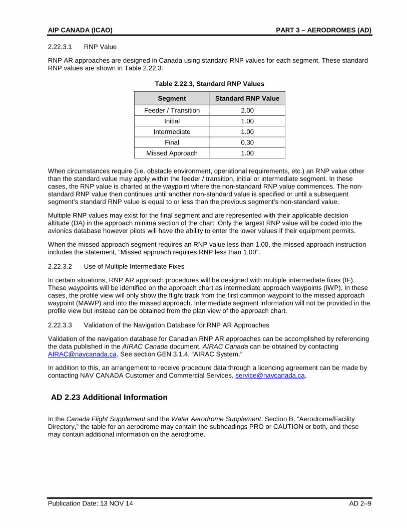
2.22.3.1 RNP Value
RNP AR approaches are designed in Canada using standard RNP values for each segment. These standard RNP values are shown in Table 2.22.3.
Table 2.22.3, Standard RNP Values
Segment Standard RNP Value
Feeder / Transition 2.00 Initial 1.00
Intermediate 1.00 Final 0.30
Missed Approach 1.00
When circumstances require (i.e. obstacle environment, operational requirements, etc.) an RNP value other than the standard value may apply within the feeder / transition, initial or intermediate segment. In these cases, the RNP value is charted at the waypoint where the non-standard RNP value commences. The non-standard RNP value then continues until another non-standard value is specified or until a subsequent segment’s standard RNP value is equal to or less than the previous segment’s non-standard value.
Multiple RNP values may exist for the final segment and are represented with their applicable decision altitude (DA) in the approach minima section of the chart. Only the largest RNP value will be coded into the avionics database however pilots will have the ability to enter the lower values if their equipment permits.
When the missed approach segment requires an RNP value less than 1.00, the missed approach instruction includes the statement, “Missed approach requires RNP less than 1.00”.
2.22.3.2 Use of Multiple Intermediate Fixes
In certain situations, RNP AR approach procedures will be designed with multiple intermediate fixes (IF). These waypoints will be identified on the approach chart as intermediate approach waypoints (IWP). In these cases, the profile view will only show the flight track from the first common waypoint to the missed approach waypoint (MAWP) and into the missed approach. Intermediate segment information will not be provided in the profile view but instead can be obtained from the plan view of the approach chart.
2.22.3.3 Validation of the Navigation Database for RNP AR Approaches
Validation of the navigation database for Canadian RNP AR approaches can be accomplished by referencing the data published in the AIRAC Canada document. AIRAC Canada can be obtained by contacting [email protected]. See section GEN 3.1.4, “AIRAC System.”
In addition to this, an arrangement to receive procedure data through a licencing agreement can be made by contacting NAV CANADA Customer and Commercial Services, [email protected].
AD 2.23 Additional Information
In the Canada Flight Supplement and the Water Aerodrome Supplement, Section B, “Aerodrome/Facility Directory,” the table for an aerodrome may contain the subheadings PRO or CAUTION or both, and these may contain additional information on the aerodrome.
PART 3 – AERODROMES (AD) NAV CANADA
AD 2–10 Publication Date: 01 FEB 18
AD 2.24 Charts Related to an Aerodrome
Canada Air Pilot, Volumes 1–7, and Restricted Canada Air Pilot, contain the following types of charts:
• Aerodrome and heliport charts,
• Aircraft parking and docking charts,
• Aerodrome taxi charts,
• Standard departure charts – instrument,
• Standard arrival charts – instrument,
• Instrument approach charts, and
• Visual approach charts.
Aerodrome obstacle charts (ICAO Type A) can be obtained by contacting the Aeronautical Publications Sales and Distribution Unit of NAV CANADA. For contact information, refer to GEN 3.2.3, “Purchase Arrangements.”
For area charts with departure and transit routes, and area charts with arrival and transit routes, refer to the following publications:
The appropriate enroute low altitude, enroute high altitude and terminal area charts (see ENR Figure 3.1, “Index to Low Altitude Charts,” and ENR Figure 3.2, “Index to High Altitude Charts”)
Canada does not currently provide precision approach terrain charts or radar minimum altitude charts.
For information on bird concentrations in the vicinity of aerodromes, refer to ENR 5.6, “Bird Migration and Areas with Sensitive Fauna.” This information can also be obtained from the aerodrome automatic terminal information service (ATIS). If the aerodrome has ATIS, it will be listed in the Canada Flight Supplement or the Water Aerodrome Supplement, Section B, “Aerodrome/Facility Directory,” table for the aerodrome under the subheading COMM.
AIP CANADA (ICAO) PART 3 – AERODROMES (AD)
Publication Date: 13 APR 06 AD 3–1
AD 3. HELIPORTS
AD 3.1 Heliport Location Indicator and Name
For the ICAO location indicators used for Canadian aerodromes, refer to the following publication:
Canada Flight Supplement, Section A, “General Section – Cross Reference of Heliport Names” and “Cross Reference of Aerodrome Location Indicator & Name”
AD 3.2 Heliport Geographical and Administrative Data
In the Canada Flight Supplement, Section B, “Aerodrome/Facility Directory,” the table for each heliport has a subheading REF that contains reference information, including the following geographical and administrative data:
• The heliport reference point (equivalent to aerodrome reference point) or the aerodrome geometric centre coordinates, as applicable (geographical coordinates in degrees, minutes and seconds), and its site;
• The direction and distance of the heliport reference point (equivalent to aerodrome reference point) or the aerodrome geometric centre coordinates, as applicable, from the centre of the city or town that the heliport serves;
• The heliport elevation;
• The magnetic variation to the nearest degree (Canada does not currently provide date of information and annual change for magnetic variation); and
• The types of traffic permitted to use the heliport (instrument flight rules [IFR] or visual flight rules [VFR] or both).
For reference temperature, refer to the weather office on Environment Canada’s website:
<weatheroffice.ec.gc.ca/canada_e.html>
In the Canada Flight Supplement, Section B, “Aerodrome/Facility Directory,” the table for each heliport has a subheading OPR that contains operations information, including the name of the heliport’s administration and its contact information.
Canada does not currently provide geoid undulation at the heliport elevation position.
AD 3.3 Operational Hours
In the Canada Flight Supplement, Section B, “Aerodrome/Facility Directory,” the table for each heliport contains information on the hours of operation for the services at the heliport, if they are provided, under the indicated subheadings:
• For the heliport administration, refer to the subheading OPR;
• For customs and immigration, refer to the subheading CUST;
• For health and sanitation, refer to the subheading PF;
• For the ARO, refer to the subheading FLT PLN;
• For the MET briefing office, refer to the subheading FLT PLN;
PART 3 – AERODROMES (AD) NAV CANADA
AD 3–2 Publication Date: 13 APR 06
• For air traffic services (ATS), refer to the subheadings FLT PLN and COMM;
• For fuelling and handling, refer to the subheading SERVICES; and
• For de-icing, refer to the subheading SERVICES; also refer to the Canada Air Pilot, Volumes 1–7, or the Restricted Canada Air Pilot.
The hours of operation for security can be obtained by contacting the operator of the heliport. For contact information, refer to the Canada Flight Supplement, Section B, “Aerodrome/Facilities Directory,” under the subheading OPR. The hours of service of the AIS briefing office can be obtained by contacting the AIS head office at NAV CANADA. For contact information, refer to the following publication:
Canada Flight Supplement, Section A, “General Section – Corrections (Civil)”
AD 3.4 Handling Services and Facilities
In the Canada Flight Supplement, Section B, “Aerodrome/Facility Directory,” the table for each heliport may have a subheading SERVICES that contains a description of the handling services and facilities available at the heliport.
AD 3.5 Passenger Facilities
In the Canada Flight Supplement, Section B, “Aerodrome/Facility Directory,” the table for each heliport may have a subheading PF (public facilities) that contains information on hotels, restaurants, transportation services, and medical facilities at the heliport. For information on banking and post office services, and whether there is a tourist office at the heliport, contact the operator. For contact information, refer to the subheading OPR.
AD 3.6 Rescue and Firefighting Services
In the Canada Flight Supplement, Section B, “Aerodrome/Facility Directory,” if the table for a heliport has a subheading SERVICES and the heliport has rescue and firefighting services and equipment, they will be listed under the ARFF entry. If the subheading SERVICES does not appear or does not contain an ARFF entry, then rescue and firefighting services and equipment may not be available at the heliport. Contact the heliport operator for further information. For contact information, refer to the subheading OPR.
AD 3.7 Seasonal Availability – Clearing
Information on the equipment and operational priorities established for the clearance of heliport movement areas is not currently provided by NAV CANADA. This information may be available by contacting the aerodrome operator in the Canada Flight Supplement, Section B, “Aerodrome/Facility Directory,” under the subheading OPR).
AIP CANADA (ICAO) PART 3 – AERODROMES (AD)
Publication Date: 13 NOV 14 AD 3–3
AD 3.8 Aprons, Taxiways and Check Locations or Positions Data
With the exception of the differences filed with ICAO by Canada, information related to the physical characteristics of aprons, taxiways and locations or positions of designated checkpoints at heliports can be found on the aerodrome sketches in the following publications:
Canada Air Pilot, Volumes 1–7, or Restricted Canada Air Pilot
Canadian Airport Charts
The latest version of the Canadian Airport Charts is available in PDF on the Aeronautical Information Products section of the NAV CANADA website:
<www.navcanada.ca> Products & Services Aeronautical Information Products Canadian Airport Charts Current Issue
AD 3.9 Markings and Markers
Refer to the aerodrome sketches in the following publications:
Canada Flight Supplement, Section B, “Aerodrome/Facility Directory”
Canada Air Pilot, Volumes 1–7, or Restricted Canada Air Pilot
Canadian Airport Charts
The latest version of the Canadian Airport Charts is available in PDF on the Aeronautical Information Products section of the NAV CANADA website:
<www.navcanada.ca> Products & Services Aeronautical Information Products Canadian Airport Charts Current Issue
AD 3.10 Heliport Obstacles
Obstacle data is currently available through the visual flight rules (VFR) chart program, including VFR navigation charts, VFR terminal area charts (VTA), and world aeronautical charts. The provision of obstacle data through the VFR chart program is supplemented by the "VFR Chart Updating Data" subsection in the Canada Flight Supplement or Water Aerodrome Supplement, Section C, “Planning.”
Additional obstacle data is available by contacting NAV CANADA. Please note that there is a charge to access this data.
Please contact:
NAV CANADA Customer Relations 77 Metcalfe Street Ottawa, ON K1P 5L6 Canada
PART 3 – AERODROMES (AD) NAV CANADA
AD 3–4 Publication Date: 13 APR 06
Tel.: 1-800-876-4693-4 (disregard the last digit if in North America) Fax: +1 613-563-3426 E-mail: [email protected]
The following information can be provided:
• Obstacle identification;
• Type of obstacle;
• Community;
• Latitude (nearest second);
• Longitude (nearest second);
• Height above sea level (ASL) (nearest foot);
• Height above ground level (AGL) (nearest foot); and
• Status of obstacle lighting and painting.
AD 3.11 Meteorological Information Provided
In the Canada Flight Supplement, Section B, “Aerodrome/Facility Directory,” the table for each heliport has a subheading FLT PLN that contains information on the meteorological information provided for the heliport.
For more information, including weather radar and satellite images, refer to the Aviation Weather Web Site on the NAV CANADA website:
<www.navcanada.ca> Aviation Weather Web Site
AD 3.12 Heliport Data
In the Canada Flight Supplement, Section B, “Aerodrome/Facility Directory,” the table for each heliport contains information on the heliport dimensions and related information, under the indicated subheadings:
• For the heliport type, whether it is surface-level, elevated or a helideck, refer to the subheading REF;
• For the dimensions and surface of the touchdown and liftoff (TLOF) area, refer to the subheading PAD DATA; and
• For the dimensions of the safety area, refer to the subheading PAD DATA.
Canada Air Pilot, Volumes 1–7, and Restricted Canada Air Pilot, provide the following information:
• Geographical coordinates and the slope and elevation of the TLOF or the final approach and takeoff (FATO) area or both (Canada does not provide geoid undulation); and
• Dimensions of helicopter clearway and the existence of an obstacle-free zone.
For the magnetic bearings (true if in NDA) and dimensions of the FATO area, refer to the aerodrome sketches in the following publications:
Canada Air Pilot, Volumes 1–7, or Restricted Canada Air Pilot
Canada Flight Supplement, Section B, “Aerodrome/Facility Directory”
AIP CANADA (ICAO) PART 3 – AERODROMES (AD)
Publication Date: 13 NOV 14 AD 3–5
AD 3.13 Declared Distances
For a description of declared distances, where relevant for a heliport, refer to the following publication:
Canada Air Pilot, Volumes 1–7, or Restricted Canada Air Pilot
AD 3.14 Approach and FATO Lighting
In the Canada Flight Supplement, Section B, “Aerodrome/Facility Directory,” the table for each heliport has a subheading LIGHTING that contains a description of approach and FATO lighting.
AD 3.15 Other Lighting, Secondary Power Supply
In the Canada Flight Supplement, Section B, “Aerodrome/Facility Directory,” the table for each heliport has a subheading LIGHTING that contains a description of other lighting, including the following information:
• Location, characteristics and hours of operation of the heliport beacon;
• Location and lighting of the wind direction indicator (WDI); and
• The taxiway edge and taxiway centre line lights.
For information on the secondary power supply, contact the operator of the heliport. In the Canada Flight Supplement, Section B, “Aerodrome/Facility Directory,” the table for each heliport has a subheading OPR that contains contact information.
AD 3.16 Air Traffic Services Airspace
For the designation, geographical coordinates, classification and vertical limits of air traffic services (ATS) airspace organized at heliports in Canada, see the Designated Airspace Handbook (TP 1820E), available on the following website:
<www.navcanada.ca> Products & Services Aeronautical Information Products Designated Airspace Handbook Current Issue
For the call signs and languages of the ATS units providing service to ATS airspace organized at heliports in Canada, see the enroute low altitude, enroute high altitude and terminal area charts (see ENR Figure 3.1, “Index to Low Altitude Charts,” and ENR Figure 3.2, “Index to High Altitude Charts”).
In the Canada Flight Supplement, Section B, “Aerodrome/Facility Directory,” when a visual flight rules (VFR) Terminal Procedures Chart is published for a heliport, it contains transition altitudes for the airspace organized at the heliport. See also the appropriate terminal area chart or VFR terminal area chart (VTA).
AD 3.17 Air Traffic Services Communication Facilities
In the Canada Flight Supplement, Section B, “Aerodrome/Facility Directory,” the table for each heliport has a subheading COMM that contains information on air traffic services (ATS) communication facilities established at the heliport.
PART 3 – AERODROMES (AD) NAV CANADA
AD 3–6 Publication Date: 6 FEB 14
AD 3.18 Radio Navigation and Landing Aids
In the Canada Flight Supplement, Section B, “Aerodrome/Facility Directory,” the table for each heliport has a subheading NAV that contains information on radio navigation and landing aids associated with the instrument approach and the terminal area procedures at the heliport. See also the following publications:
Canada Air Pilot, Volumes 1–7, or Restricted Canada Air Pilot
The appropriate terminal area chart
AD 3.19 Local Traffic Regulations
In the Canada Flight Supplement, Section B, “Aerodrome/Facility Directory,” the table for a heliport may contain the subheadings PRO or CAUTION or both, and these contain information on regulations applicable to the traffic at the heliport, including standard routes for taxiing helicopters, parking regulations, training flights and similar information.
AD 3.20 Noise Abatement Procedures
In the Canada Flight Supplement, Section B, “Aerodrome/Facility Directory,” the table for a heliport may have a subheading PRO, which may contain information on the noise abatement procedures established at the heliport. See also the following publications:
Canada Air Pilot, General, Volumes 1–7, or Restricted Canada Air Pilot
AD 3.21 Flight Procedures
In the Canada Flight Supplement, Section B, “Aerodrome/Facility Directory,” when a visual flight rules (VFR) Terminal Procedures Chart is published for a heliport, it contains information on conditions and flight procedures, including radar procedures, established on the basis of airspace organization at the heliport. See also the following publications:
Canada Air Pilot, Volumes 1–7, or Restricted Canada Air Pilot
The process documentation concerning the submission of instrument procedures by external instrument procedure design organizations can be found on the NAV CANADA website:
<www.navcanada.ca> Products & Services Aeronautical Information Products Aeronautical Information Submissions External Design Organization Documents P-IPD-101 IPD Submission Manual
Submissions will be accepted for both public procedures to be published in the CAP and restricted procedures to be published in the RCAP.
AIP CANADA (ICAO) PART 3 – AERODROMES (AD)
Publication Date: 27 JUN 13 AD 3–7
3.21.1 Duplicate Approach Procedure Identification
With the increase in instances of published duplicate approach procedures (same approach type to the same runway), changes were made to the ARINC 424 document to accommodate a duplicate approach procedure suffix in the procedure identifier record of an avionics database. This allows for all duplicate approach procedures to be coded and made available onboard aircraft with suitable avionics equipment.
However, many existing avionics units cannot accept this suffix in their procedure identification records. These units only allow for a four-character approach procedure identifier. For this reason, when duplicate approach procedures are published for an aerodrome, only one of the approach procedures can be coded into the databases of these particular avionics units.
To ensure the appropriate approach procedure is coded into avionics databases in these cases, NAV CANADA has developed and implemented a system for designating the predominant approach procedure. Duplicate approach procedures are differentiated using alpha characters starting with the last letter and continuing backward through the alphabet (Z, Y, X, etc.). The predominant approach procedure will be identified using the “Z” suffix (i.e., RNAV (GNSS) Z RWY 25). It is intended that the approach procedure identified with the “Z” suffix be the one procedure coded in an avionics database when only one duplicate approach procedure can be coded in the system. NAV CANADA assigns the “Z” suffix in accordance with the following priority:
1. Approach procedure intended for all/most customers vs. some customers.
2. Public approach procedure vs. restricted approach procedure.
3. Lower minima vs. higher minima.
Circling-only procedures are designated in Canada using alpha characters starting with the first letter of the alphabet (A, B, C, etc.). If similar database limitations exist with respect to circling-only procedures at the same aerodrome (i.e., NDB A, NDB B), the predominant approach procedure will be the procedure that has the first letter within the sequence (i.e., “A” predominant over “B”).
When an avionics database can accommodate duplicate approach procedures, all instrument procedures provided by NAV CANADA will be inserted into the database.
3.21.2 Management of Avionics Databases: Limited Storage Capability
To ensure the suitability of the available instrument procedures in general avionics databases that have limited storage capability, database providers shall only reduce the database inventory of available procedures on a whole aerodrome basis. When eliminating instrument procedures from a general avionics database for limited storage capacity reasons, all procedures existing for a given aerodrome (or aerodromes) must be removed. A general avionics database shall never contain only some of the instrument procedures for a specific aerodrome in Canada, unless this is necessary for reasons related to duplicate approach procedure identification. This practice may be applied in a larger scale by removing all procedures from all aerodromes within a specified area, region, or province.
Customized databases may continue to be compiled as requested by the customer for whom the custom database is intended. The rules described above pertaining to general avionics databases are not intended to be applicable to customized avionics databases.
Database coding providers and avionics manufacturers with questions or suggestions can contact NAV CANADA AIM Development at ncrga_ais_standards&@navcanada.ca.
AD 3.22 Additional Information
In the Canada Flight Supplement, Section B, “Aerodrome/Facility Directory,” the table for a heliport may contain the subheadings PRO or CAUTION or both, and these may contain additional information on the heliport.
PART 3 – AERODROMES (AD) NAV CANADA
AD 3–8 Publication Date: 13 JAN 11
AD 3.23 Charts Related to a Heliport
Canada Air Pilot, Volumes 1–7, and Restricted Canada Air Pilot contain the following types of charts:
• Aerodrome and heliport charts,
• Aircraft parking and docking charts,
• Aerodrome taxi charts,
• Standard departure charts – instrument,
• Standard arrival charts – instrument,
• Instrument approach charts, and
• Visual approach charts.
For area charts with departure and transit routes, and area charts with arrival and transit routes, refer to the following publications:
The appropriate enroute low altitude, enroute high altitude and terminal area charts (see ENR Figure 3.1, “Index to Low Altitude Charts,” and ENR Figure 3.2, “Index to High Altitude Charts”)
Canada does not currently provide radar minimum altitude charts.
For information on bird concentrations in the vicinity of heliports, refer to ENR 5.6, “Bird Migration and Areas with Sensitive Fauna.” This information can also be obtained from the automatic terminal information service (ATIS). If the heliport has ATIS, it will be listed in the Canada Flight Supplement, Section B, “Aerodrome/Facility Directory,” table for the heliport under the subheading COMM.