


Languages
Pages
Legal


DACD / IST / Latest Activities @ Division of Geomatics
SITGAP 2.0 Comprehensive system for risk management
M. Cannata, M. Antonovic
ICA-OSGeo-ISPRS lab

SITGAP 2.0 MANAGEMENT, ALARM AND EVACUATION SYSTEM FOR LOCARNO
AND VALLEMAGGIA CIVIL PROTECTION
Object of the Study:
DESIGN AND IMPLEMENTATION OF NEW SOLUTIONS FOR THE
IMPLEMENTATION OF AN EASY-TO-UPDATE SYSTEM SUPPORTING
CIVIL PROTECTION ACTIVITIES
04/12/2014
2
04/12/2014 04/12/2014
Data providers:

DACD / IST / SITGAP 2.0
Why is the Lake Verbano exposed to flood risk?
04/12/2014
3
Basin = 6,386 km2
Lake = 213 km2
Discharge
max = ca. 2,000 m3/s
medio pre-alarm alarm 5
Lake Levels 193.66 194.85 195.75

DACD / IST / SITGAP 2.0
Considerable economic costs

DACD / IST / SITGAP 2.0
Flood of the 12-21.11.2014 max lake level 196.42
04/12/2014
5
DACD / IST / SITGAP 2.0
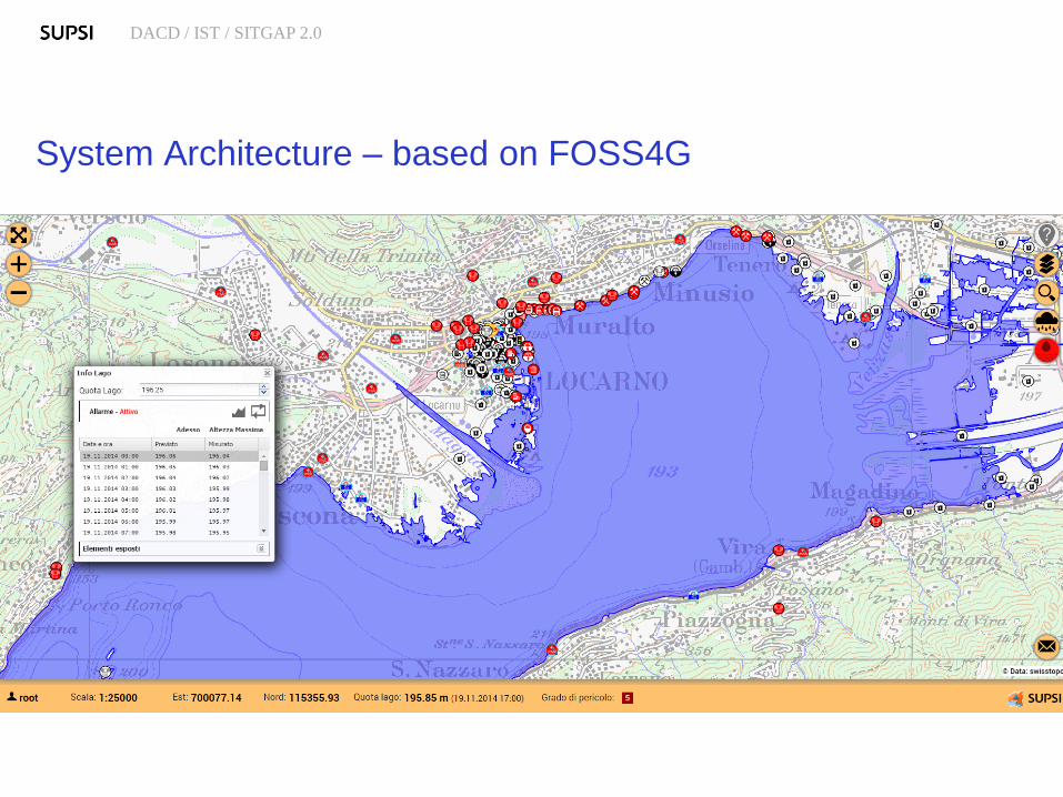
System Architecture – based on FOSS4G

DACD / IST / SITGAP 2.0
EWS components
WORKFLOW
Meteorological
Forecasts
Hydrological
modelling
Data Validation
Data Sharing
Early Warning
DSS:
SITGAP 2.0
Hydro-meteo
monitoring
network
Sensor Data
GIS Data SOA

DACD / IST / SITGAP 2.0
EWS components
with open standard
and open software
Meteorological
Forecasts
PostGIS &
WPS
Hydrological modelling
pyWPS
Data Validation
istSOS, WPS
Data Sharing
SOS, JSON,
ASCII
Early Warning DSS
OpenLayers &
PostGIS &
Python REST
Hydro-meteo
monitoring network
Python scripts
ASCII to SOS
Sensor Data
istSOS
GIS Data
Geoserver WMS /
WFS

04/12/2014
9 Mode «Regular»: access to
data and funtions for
resources management (search for parcel, address or person,
query and eventually edit elements
details, etc.)
Mode «Alarm»: access to
forecasted lake levels and
exposed elements data (detect exposed elements with a given
lake level, see plots of forecasted lake
level, access instructions to secure
exposed elements, etc.)
Mode «Evacuation»: access
to datails of population to
manage evacuation (create evacauation event, search and
locate person, count people in an area,
assign people an evacauatio status,
etc.)
Mode «Dams»: access to
dam-break hazard zones and
wave arrival times

Unique Visitors: 50
Requests / Second: 2.5 - 30
REQUESTS Requests Bandwidth
SITGAP Web Services 25’372 0.83 GB
WMS 190’112 2.57 GB
Total 215’484 3.4 GB
REQUESTS % ERROR CODE
205132 95.20 OK - The request sent by the client was successful 200
9568 4.44 Not Modified - Resource has not been modified 304
401 0.19 Unauthorized - Request needs user authentication 401
365 0.17 Bad Request - The syntax of the request is invalid 400
5 0.002 Document Not Found - Requested resource could not be
found
404
10 0.004 Internal Server Error 500
Average Daily Statistics during the last flood

DACD / IST / SITGAP 2.0
What’s next
• Perform loading test (even if during the recent alarm
the civil protection stated the system worked really
great!!)
• Improve the system feature with capability to draw,
save and print evacuation indication for different
cases (dam break, etc.)
• Idea to extend the Management System to landslide
risk (partner search..) and possibly export to other
regions/districts

DACD / IST / SITGAP 2.0
Thanks
www.supsi.ch/ist [email protected]
04/12/2014
12
http://geomatica-supsi.blogspot.ch/
http://geoservice.ist.supsi.ch/+geomatics
12
Top Related