


Languages
Pages
Legal


Proposing a Framework for NSDI Stakeholder Analysis:
A Case Study in Indonesia
Ta n d a n g Yu l i a d i D w i P u t ra ( ta n d a n g @ i i s . u - to k yo . a c . j p / ta n d a n g .y u l i a d i @ b i g . go . i d )
18-21 September 2018Antwerp, Belgium
Session: National approaches, strategies and international cooperation Room: Okapi 3 Time: Friday, 21 September 2018

A Mindmap of Spatial Data Infrastructure
2

3
The role of actors is a source of SDI complexity
SDI Stakeholders refer to individual or group with an interest in the success of an SDI in delivering its intended results and maintaining the viability of its products. Stakeholders either affect the SDI or are affected by it (Hjelmager et al., 2008)
Proposing a Framework for NSDI Stakeholder Analysis: A Case Study in Indonesia

4
Problem of NSDI stakeholders involvement in Indonesia
Central Government Agencies (64)
Provinces (34)
Municipalities/Districts (514)
National Armed Force
State Institutions (8)
NSDI
National Police
Type of Institution Number of
Institutions
Connected
to NSDI*
Connected
to NSDI (%)
State Institutions 8 0 0%
Central Government
Agencies, Police &
Armed Force
66 11 16.7%
Provinces 34 17 50%
Municipalities/Districts 514 10 1.9%
TOTAL 622 38 6.1%
*Source: www.tanahair.go.id as per April 2018
Proposing a Framework for NSDI Stakeholder Analysis: A Case Study in Indonesia

5
Low availability of data providers and datasets
12 15
778
340
0
200
400
600
800
1000
Sep 2016 Sep 2017
NSDI Data Providers & Datasets Availability
Number of Data Providers (services are accessible)
Number of Datasets Available (to download or as web services)
5 Institutions were quit providing services:- Ministry of Tourism (58)- BMKG (96 services)- BNPB (46) - Aceh Province (257)- South Kalimantan Province (44)
8 new data providers: - Ministry of Energy & MR (29)- Ministry of Home Affairs (14) - West Java Province (2)- Depok City (2)- Balikpapan City (33)- Bontang City (34)- Klaten Municipality (15)- Sumbawa Municipality (9)
Proposing a Framework for NSDI Stakeholder Analysis: A Case Study in Indonesia

6
Why do problems of NSDI Stakeholders occur?
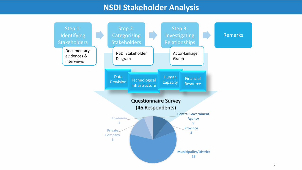
Step 1:Identifying
Stakeholders
Step 2:Categorizing Stakeholders
Step 3:Investigating Relationships
Remarks
Documentary evidences & interviews
NSDI Stakeholder Diagram
Actor-Linkage Graph
7
NSDI Stakeholder Analysis
Data Provision Technological
Infrastructure
Human Capacity
Financial Resource
Questionnaire Survey (46 Respondents)
Central Government Agency
5
Province4
Municipality/District28
Private Company
6
Academia3

Stakeholders of Indonesia NSDI
1. Geospatial Information Agency (BIG)
2. Central Government Agencies
3. State Institutions
4. Provincial Government
5. Municipal/District Government
6. National Police
7. National Armed Force
8. Center of SDI Development in university (PPIDS)
9. Survey & Mapping Companies
10. Geospatial Application Developers
11. GIS Software Providers
12. NGOs/NPOs
13. Lecturers/Researchers
14. Students
15. Citizens
Step 1: Identifying Stakeholders
8

NSDI Stakeholders Table
9
Step 2: Categorizing Stakeholders
Stakeholders Interests Resources Influence
Geospatial Information Agency (BIG)
• Disseminate basic geospatial information
• Collect thematic data• Establish network nodes connection• Access web services
• Annual budget allocation• Data center• GIS software, surveying tools, CORS
infrastructure• Nation-wide topographic maps• Human resources
High
Central GovernmentAgencies
• Collect topographic maps• Share thematic data• Access web services
• Budget allocation• GIS software, computer, and Internet network• Thematic data• Human resources
High
Geospatial Application Developers
• Collect basic and thematic data• Access web services
• GIS software, computer, and Internet network• Human resources
Low
Lecturers/ Researchers • Collect basic and thematic data• Access web services
• GIS software, computer, and Internet network Low
Proposing a Framework for NSDI Stakeholder Analysis: A Case Study in Indonesia

Power-Interest Grid
10
Step 2: Categorizing Stakeholders
1. Geospatial Information Agency (BIG)2. Central Government Agencies3. State Institutions4. Provincial Government5. Municipality/District Government6. National Police7. National Armed Force8. Center of SDI Development in university (PPIDS)9. Survey & Mapping Companies10. Geospatial Application Developers11. GIS Software Providers12. NGOs/NPOs13. Lecturers/Researchers14. Students15. Citizens
4
low
high
low high
Power
Interest
Key PlayersContext Setters
Crowd Subjects
1
2
35
6
7
8
910
1112
13
14
15
Proposing a Framework for NSDI Stakeholder Analysis: A Case Study in Indonesia

11
Step 2: Categorizing Stakeholders
Features of Stakeholder CapabilitiesData Provision
Scale Indicator
1 No geospatial data available
2 Non-GIS data format available
3 Basic geospatial data available
4 Basic & thematic data available
5 Basic & thematic data conform with the national catalogue
Human Capacity
Scale Indicator
1 No GIS workers available
2 Small number of GIS workers (1-5 people)
3 Several GIS workers available (6-10 people)
4 Large number GIS workers available (>10 people)
5 Large number and Professional GIS workers
Financial Resource
Scale Indicator
1 No budget for data provision & dissemination
2 Incidental (non-routine) budget
3 Annually small budget (< 1 Billion IDR)
4 Annually medium budget ( 1-5 Billion IDR)
5 Annually large budget (>5 Billion IDR)
Technological Infrastructure
Scale Indicator
1 No GIS software/hardware & Internet network
2 GIS Software or Internet network available
3 GIS Software/hardware & Internet network available
4 GIS Software/hardware, Server & Internet network
5 Geoportal & dedicated data center available

Survey Results
12
Step 2: Categorizing Stakeholders
0%
20%
40%
60%
80%
100%
Technological Infrastructure
1-No GIS software/hardware & Internet network 2-GIS Software or Internet network available
3-GIS Software/hardware & Internet network available 4-GIS Software/hardware, Server & Internet network available
5-Geoportal & dedicated data center available
BIG and 80% of central gov
agencies have good
infrastructure
Most of Municipalities/
Districts do not have resource for data
publication
Private sectors & PPIDS are capable
in publishing services
Proposing a Framework for NSDI Stakeholder Analysis: A Case Study in Indonesia

NSDI Stakeholder Diagram
13
Step 2: Categorizing Stakeholders
1. BIG2. Central Government Agencies3. State Institutions4. Provincial Government5. Municipality/District
Government6. National Police7. National Armed Force8. Center of SDI Development in
university (PPIDS)9. Survey & Mapping Companies10. Geospatial Application
Developers11. GIS Software Providers12. NGOs/NPOs13. Lecturers/Researchers14. Students15. Citizens
Crowd Subjects
Context Setters Key Players5
1
Data Provision
Financial Resource
Technological Infrastructure
Human Capacity
1
36
7
2
2
3
4
8
4
910
111213
14
15
5
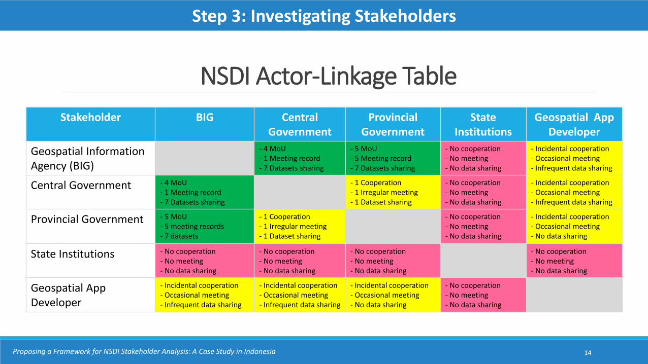
NSDI Actor-Linkage Table
14
Stakeholder BIG Central Government
ProvincialGovernment
State Institutions
Geospatial AppDeveloper
Geospatial Information Agency (BIG)
- 4 MoU- 1 Meeting record- 7 Datasets sharing
- 5 MoU- 5 Meeting record- 7 Datasets sharing
- No cooperation- No meeting- No data sharing
- Incidental cooperation- Occasional meeting- Infrequent data sharing
Central Government - 4 MoU- 1 Meeting record- 7 Datasets sharing
- 1 Cooperation- 1 Irregular meeting- 1 Dataset sharing
- No cooperation- No meeting- No data sharing
- Incidental cooperation- Occasional meeting- Infrequent data sharing
Provincial Government - 5 MoU- 5 meeting records- 7 datasets
- 1 Cooperation- 1 Irregular meeting- 1 Dataset sharing
- No cooperation- No meeting- No data sharing
- Incidental cooperation- Occasional meeting- No data sharing
State Institutions - No cooperation- No meeting- No data sharing
- No cooperation- No meeting- No data sharing
- No cooperation- No meeting- No data sharing
- No cooperation- No meeting- No data sharing
Geospatial App Developer
- Incidental cooperation- Occasional meeting- Infrequent data sharing
- Incidental cooperation- Occasional meeting- Infrequent data sharing
- Incidental cooperation- Occasional meeting- No data sharing
- No cooperation- No meeting- No data sharing
Step 3: Investigating Stakeholders
Proposing a Framework for NSDI Stakeholder Analysis: A Case Study in Indonesia

NSDI Actor-Linkage Graph
15
Step 3: Investigating Stakeholders
4
low
high
high
Power
Interest
1
2
35
6
7
8
9
10
1112
13
14
15
Strong relation
Weak relation
Unconnected
Proposing a Framework for NSDI Stakeholder Analysis: A Case Study in Indonesia
1. Geospatial Information Agency (BIG)2. Central Government Agencies3. State Institutions4. Provincial Government5. Municipality/District Government6. National Police7. National Armed Force8. Center of SDI Development in university (PPIDS)9. Survey & Mapping Companies10. Geospatial Application Developers11. GIS Software Providers12. NGOs/NPOs13. Lecturers/Researchers14. Students15. Citizens

Remarks
16
● The key players ( , , , ) of Indonesia NSDI are mainly from government agencies that have resources on data, budget and technological infrastructure
● Municipalities/Districts ( ) have limitations in publishing their geospatial data hence resulted in lack of participation
● The awareness of geospatial information benefits need to be raised to the context setters ( , , )
● Strong collaboration is required between private sectors ( , , ) and government institutions to enlarge NSDI
NSDI Stakeholder Analysis
1 2 4 5
5
3 6 7
9 10 11
Proposing a Framework for NSDI Stakeholder Analysis: A Case Study in Indonesia

Conclusion
● Indonesia NSDI effectively provide data sharing and reduce data duplication among government agencies however other actors is passively influence the implementation
● NSDI Stakeholder Diagram and NSDI Actor-Linkage Graph can be used as a framework for categorizing and defining stakeholder’s interactions
● Collaboration with business sector, academia and community is essential to broaden NSDI scope and usage
● Future study is necessary to verify NSDI Stakeholder Analysis in different NSDI setting
17Proposing a Framework for NSDI Stakeholder Analysis: A Case Study in Indonesia

Thank you for your attention...
Top Related