


Languages
Pages
Legal


Appendix R. . . . . . . . . . . . . . . . . . . . . . . . . . . . . . . . . . . . . . . . . . . . . . . . . . . . . . . . . . . . . . . . . . . . . . . . . . .Baseline turtle survey. . . . . . . . . . . . . . . . . . . . . . . . . . . . . . . . . . . . . . . . . . . . . . . . . . . . . . . . . . . . . . . . . . . . . . . . . . .
Baseline turtle survey
Phoenix Environmental Sciences, February 2011. Long-necked Turtle Baseline Survey for Roe Highway Extension Project. Unpublished report prepared for South Metro Connect, Perth, WA.

Long-necked Turtle Baseline Survey for the Roe Highway Extension Project South Metro Connect
Final Report
Phoenix Environmental Sciences Pty Ltd i
4
Long-necked Turtle Baseline Survey for Roe Highway Extension Project
Prepared South Metro Connect
Final Report
February 2011

Long-necked Turtle Baseline Survey for the Roe Highway Extension Project South Metro Connect
Final Report
Phoenix Environmental Sciences Pty Ltd ii
Long-necked Turtle Baseline Survey for the Roe Highway Extension Project
Prepared for South Metro Connect
Final Report
Authors: Mary-Anne Clunies-Ross
Reviewers: Jarrad Clark, Karen Crews
Date: February 2011
Submitted to: Jamie Shaw and Peter Magaro (AECOM Australia Ltd)
© Phoenix Environmental Sciences Pty Ltd 2011.
The use of this report is solely for the Client for the purpose in which it was prepared. Phoenix
Environmental Sciences accepts no responsibility for use beyond this purpose.
All rights are reserved and no part of this publication may be reproduced or copied in any form without
the written permission of Phoenix Environmental Sciences Pty Ltd or AECOM Pty Ltd.
Phoenix Environmental Sciences Pty Ltd
1/511 Wanneroo Road
BALCATTA WA 6023
P: 08 9345 1608
F: 08 6313 0680
Project code: 967-ROE-AEC-FAU

Long-necked Turtle Baseline Survey for the Roe Highway Extension Project South Metro Connect
Final Report
Phoenix Environmental Sciences Pty Ltd iii
TABLE OF CONTENTS
EXECUTIVE SUMMARY ........................................................................................................................ 5
1 INTRODUCTION ............................................................................................................................. 6
1.1 Background ............................................................................................................................... 6
1.2 Scope of Work and Survey Objectives ..................................................................................... 8
2 EXISTING ENVIRONMENT ............................................................................................................ 9
2.1 Interim Biogeographic Regionalisation of Australia (IBRA) Region ......................................... 9
2.2 Landforms and Vegetation ....................................................................................................... 9
2.3 Climate .................................................................................................................................... 12
2.4 Land Use ................................................................................................................................ 12
2.5 Previous Surveys .................................................................................................................... 13
3 LIFE HISTORY AND ECOLOGY ................................................................................................... 14
3.1 Habitat .................................................................................................................................... 14
3.2 Breeding and Nesting ............................................................................................................. 14
3.3 Threatening Processes ........................................................................................................... 15
4 METHODOLOGY ........................................................................................................................... 16
4.1 Consultation ............................................................................................................................ 16
4.2 Habitat Assessment and Site Selection.................................................................................. 16
4.3 Survey Effort ........................................................................................................................... 16
4.3.1 Hand Collection and Net Scooping ................................................................................. 16
4.3.2 Active Searching.............................................................................................................. 17
4.4 Biological Parameters Recorded ............................................................................................ 17
4.5 Limitations ............................................................................................................................... 18
5 RESULTS ...................................................................................................................................... 20
5.1 Local Distribution .................................................................................................................... 20
5.2 Population Density Estimates ................................................................................................. 20
5.3 Population Dynamics and Structure ....................................................................................... 20
5.3.1 Condition Index................................................................................................................ 21
5.3.2 Ecological Indicators ....................................................................................................... 23
5.4 Movements ............................................................................................................................. 23
5.4.1 Weather Conditions ......................................................................................................... 23
5.4.2 Accesss To Suitable Nesting Habitat .............................................................................. 25
6 DISCUSSION AND CONCLUSION ............................................................................................... 27
7 REFERENCES .............................................................................................................................. 28
APPENDIX 1 TURTLES RECORDED IN BIBRA LAKE DURING THE OCTOBER 2010 SURVEY .... 30
LIST OF TABLES
Table 4-1 Location of Oblong Turtle survey areas. ........................................................................ 16

Long-necked Turtle Baseline Survey for the Roe Highway Extension Project South Metro Connect
Final Report
Phoenix Environmental Sciences Pty Ltd iv
Table 4-2 Limitations of the Oblong Turtle baseline survey ........................................................... 18
Table 5-1 Basic population statistics (carapace length) for turtles caught in Bibra Lake ............... 21
Table 5-2 Ecological Indictors on Male and Female turtles caught in Bibra Lake ......................... 23
LIST OF FIGURES
Figure 1-1 Location of the Roe Highway Extension Project .............................................................. 7
Figure 2-1 Soil types and vegetation complexes of the Roe Highway Extension Project ............... 11
Figure 2-2 Daily minimum and maximum temperatures at Jandakot Airport during the survey period
(4-8 October 2010) ......................................................................................................... 12
Figure 5-1 Size structure of male turtles caught from Bibra Lake ................................................... 21
Figure 5-2 Size structure of female turtles caught from Bibra Lake ................................................ 21
Figure 5-3 Linear regression comparing carapace length to body mass for male turtles caught in
Bibra Lake ...................................................................................................................... 22
Figure 5-4 Linear regression comparing carapace length to body mass for female turtles caught in
Bibra Lake ...................................................................................................................... 22
Figure 5-5 Barometric pressure and rainfall recorded during the month of October 2010 .............. 24
Figure 5-6 Minimum and maximum temperatures recorded during the month of October 2010 .... 25
LIST OF PLATES
Plate 1 Oblong Turtle caught in Bibra Lake ................................................................................. 6
Plate 2 Lake habitats surveyed (wet and dry) ............................................................................ 17
Plate 3 Algal and fungal growth present on an individual. ......................................................... 23
Long-necked Turtle Baseline Survey for the Roe Highway Extension Project South Metro Connect
Final Report
Phoenix Environmental Sciences Pty Ltd 5
EXECUTIVE SUMMARY
South Metro Connect commissioned Phoenix Environmental Sciences Pty Ltd (Phoenix) to
undertake a baseline survey for the Long-necked Turtle (Chelodina Oblonga) (herein referred
to as the ‘Oblong Turtle’), within the project area (‘the project area’) of the Roe Highway
Extension Project (‘the proposed project’).
The Oblong Turtle is not listed as a species of conservation significance but considered to be
of local significance. The survey aimed to collect baseline information on Oblong Turtle
populations within the project area, in particular population estimates, dynamics, health and
local distribution. It also aimed to identify any potential upland nesting movements.
Twenty three adult Oblong Turtles (16 females and 7 males) and no juveniles were captured
at Bibra Lake, representing the minimum population size at the lake. Thirty-seven turtles were
seen within the lake but not captured. There were no recaptures. No turtles were seen or
captured in North Lake.
The size structure (carapace length) for both male and female captures were within normal
ranges based on results from previous surveys. Carpace length in male turtles ranged from
18-23cm (average of 20.5cm) and in female turtles ranged from 18-25cm (average of
22.3cm). No gravid females were caught within this survey.
More than half of the individuals captured (52.1%) had ecological indicators, with algal growth
the most prevalent indicator. Eighty five percent of males had ecological indicators present
compared with 43% of females. Strong to moderate positive correlations were evident
between carapace length and body mass in both sexes. Generally, the turtles sampled were
in good to very good condition with only one individual considered to be in satisfactory
condition.
The turtle population in Bibra Lake is likely to be substantially larger than the sample size
captured, given limitations with sampling, lack of recaptures and lack of juvenile captures.
Based on the available data, the minimum population density estimate for the Oblong Turtle
within Bibra Lake is approximately 168 turtles in 157ha, approximately 1.058 turtles per ha.
This suggests that an area of 0.93ha needs to be surveyed before one turtle is expected to be
caught.
The presence of adult turtles suggests that the long-term viability of this population is
possible, but also dependant on other habitat requirements. Although no turtles were captured
in North Lake anecdotal evidence and opportunistic findings (turtle remains) suggest that they
have been previously present in this area.
Terrestrial habitat assessments suggest that turtle populations within these lakes may be
restricted in their upland nesting movements due to the presence of retaining walls, steep lake
side banks, thick non-native grasslands and the presence of dense Typha sp. fringing these
wetlands. Increased fragmentation of upland habitats, weed invasion, road mortality and
predation are also existing threats to this species which may limit their dispersal and breeding
success.

Long-necked Turtle Baseline Survey for the Roe Highway Extension Project South Metro Connect
Final Report
Phoenix Environmental Sciences Pty Ltd 6
1 INTRODUCTION
South Metro Connect commissioned Phoenix Environmental Sciences Pty Ltd (Phoenix) to
undertake a baseline survey for the Long-necked Turtle (Chelodina Oblonga) (herein referred
to as the ‘Oblong Turtle’), within the project area (‘the project area’) of the Roe Highway
Extension Project (‘the proposed project’).
1.1 BACKGROUND
The Government of Western Australia (Main Roads WA) is planning to extend Roe Highway
from its current connection to Kwinana Freeway in Jandakot to Stock Road in Coolbellup.
The proposed alignment for the highway between the Kwinana Freeway and North Lake Road
is within the existing Primary Regional Roads Metropolitan Regional Scheme (MRS) boundary
that divides the Beeliar Regional Park between Bibra Lake and North Lake (Figure 1-1).
The project area is considered to be of high environmental value and as such, extensive
biological surveys are required as part of the environmental impact assessment for the
proposed project.
This baseline survey was developed in response to local community concern about the
potential impact of the proposed project on the Oblong Turtle and to contribute to local
knowledge of the Oblong Turtle in the North Lake/Bibra Lake area (Plate 1). The species is
not of conservation significance but is of local significance to the project area.
Plate 1 Oblong Turtle caught in Bibra Lake

Datum: GDA94 Projection: MGA z50
Figure 1-1Location of theRoe Highway
Extension Project
Swan River
BooragoonLake
North Lake
Bibra Lake
South Lake
Little Rush Lake
Yangebup Lake
Kogolup Lake
ThomsonsLake
Market GardenSwamp
Manning Lake
Canning River
K w
i n
a n
a F
w y
S o u t h S t
C o
c k
b u
r n
R d
C a n n i n g H w y
L e a c h H w y
N o r t h
L a k eR d
S to
ck
Rd
R o e
H w y
Ka
r e l
Av
S o u t hS t
M a n n i n g R d
!!
!!
!!
!!
!! !!
!!
!!
Perth
Morley MidlandStirling
Armadale
Fremantle
Cannington
Rockingham
0 1 2 3
Kilometres
Project Area
Date Modified: 15/02/2011Author: unknown J:\Client_Data\Main_Roads\60100953_Roe_Extension\Workspaces\#2011\Technical_Reports\SRE and Inverts Baseline Survey\Figure 1-1 - Location of the Roe Highway Extension Project.mxd
°°°

Long-necked Turtle Baseline Survey for the Roe Highway Extension Project South Metro Connect
Final Report
Phoenix Environmental Sciences Pty Ltd 8
1.2 SCOPE OF WORK AND SURVEY OBJECTIVES
Survey design for this baseline study is consistent with the Environmental Protection
Authority’s (EPA) Guidance Statement No. 56: Terrestrial Fauna Surveys for Environmental
Impact Assessment in Western Australia (EPA 2004) and EPA Position Statement No. 3:
Terrestrial Biological Surveys as an Element of Biodiversity Protection (EPA 2002).
The aim of this project was to conduct a baseline survey for the North Lake/Bibra Lake
Oblong Turtle population. The specific objectives of the baseline survey were to:
Estimate the number of individuals (population size at Bibra Lake and North Lake),
the population dynamics, health, local distribution;
Identify any movement patterns within the project area;
Determine the significance of the results; and
Identify any management considerations.

Long-necked Turtle Baseline Survey for the Roe Highway Extension Project South Metro Connect
Final Report
Phoenix Environmental Sciences Pty Ltd 9
2 EXISTING ENVIRONMENT
2.1 INTERIM BIOGEOGRAPHIC REGIONALISATION OF AUSTRALIA
(IBRA) REGION
The project area lies within the Swan Coastal Plain (SWA2) subregion of the Interim
Biogeographic Regionalisation of Autralia v. 6.1 (IBRA) (Thackway and Cresswell 1995).
Landforms within the region are composed of colluvial and aeolian sands, alluvial river flats
and coastal limestone. The vegetation of the region broadly consists of Banksia and Jarrah-
Banksia woodlands on Quaternary marine dunes of various ages and Marri on colluvial and
alluvial substrates (Mitchell et al 2002). The subregion includes a complex series of seasonal
wetlands associated with low-lying interdunal areas (WAPC 2000a; Mitchell et al 2002).
Rare features of the subregion include Holocene dunes and wetlands and, because it is part
of the South West Botanical Province, the subregion is characterised by high species and
ecosystem diversity compared to other areas.
2.2 LANDFORMS AND VEGETATION
The region in which the project area resides consists of several interacting landform elements,
including Bassendean Sands of the Bassendean Dunes landform, Sands derived from
Tamala Limestone (Spearwood Dune System) and Holocene Swamp Deposits (peaty silts
within the Spearwood Bassendean Dune interface (Figure 2-1). Vegetation complexes such
as plant communities or patterns of vegetation are associated with landforms and soil types
that exist at a regional scale (Tingay 1998).
Vegetation complexes within the project area comprise of Bassendean, Herdsman, Karrakatta
and Cottlesloe complexes (Heddle et al 1980). These complexes and their associated
geological soil types are further described as follows:
Bassendean Complex (central, west and south) – Woodland of Eucalyptus marginata,
Corymbia calophylla with well defined second storey of Calytrix fraseriana and
Banksia species on the deeper soils and a closed scrub on the moister sites. Soil
type is S8 (Sand) - very light grey at surface, yellow at depth, fine to medium-grained,
sub-rounded quartz, moderately well sorted, of aeolian origin.
Herdsman Complex (North Lake and Bibra Lake) - Sedgelands and fringing woodland
of Eucalyptus rudis and Melaleuca preissiana, M. rhaphiophylla and Banksia ilicifolia
forest to woodland with Kunzea glabrescens, Acacia saligna and Agonis linearifolia;
Melaleuca teretifolia tall shrubland; and Baumea articulata and Typha orientalis
sedgelands. Soil type is Mps (Peaty Silt) - black, friable silt with abundant organic
material, variable fine quartz sand content, soft, of lacustrine origin.
Karrakatta Complex (central and south) - Open forest of Eucalyptus gomphocephala,
E. marginata, Corymbia calophylla and woodland of E. marginata and Banksia
species. Soil type is S7 (Sand) - pale yellowish brown, medium to coarse-grained
sub-angular quartz, trace of feldspar, moderately sorted, of residual origin.
Cottesloe Complex (central and west) - Open woodland of Eucalyptus
gomphocephala, E. marginata and Corymbia calophylla; closed heath on the
limestone outcrops. Soil type is LS1 (Limestone) - pale yellowish brown, fine to
coarse-grained, sub-angular to well rounded, quartz, trace of feldspar, shell debris,
variably lithified, surface kankar of aeolian origin.
In terms of remnant vegetation surrounding the proposed project, vegetation linkages include
adjacent bushland to the north and south (Piney Lakes Reserve, Booragoon Lake, Blue Gum
Reserve, Samson Park, Wireless Hill, Little Rush Lake, Yangebup and Thompsons Lakes
which also form part of Greenways 82 and 90) west (Manning Lake, Coogee Lake) east (Ken
Hurst Park and Jandakot Airport)(Tingay 1998).

Long-necked Turtle Baseline Survey for the Roe Highway Extension Project South Metro Connect
Final Report
Phoenix Environmental Sciences Pty Ltd 10
The project area also forms part of three regionally significant ‘ecological linkages‘, which
connect Bush Forever sites, Department of Environment and Conservation (DEC) managed
estate and adjacent local natural areas. The first linkage lies in a north-south direction east of
the Beeliar Wetlands. The second linkage starts in the south-west of the project area and
connects the North Lake and Bibra Lake area to the west of the Beeliar Regional Park (Lake
Coogee). The third linkage connects the North-Bibra Lake area to remnant bushland to the
west.

S8
S7
LS1
Mps
S8
S10
Water
Water
Ms5
S10
Water
Ms5
S7
S10
S7
Water
Ms5
Mps
Mps
Ms5
Ms5
Mps
Ms5
S10
Ms5
S7
Water
Cps
Mps
Ms5
Cps
Ms5
Water
Water
Cps
°0 0.25 0.5 0.75 1
Kilometres
1:35,000 (A4)
Datum: GDA94 Projection: MGA z50
Project Area
Study Area
Geological Landforms
Cps - Peaty clay
Mps - Peaty silt
Ms5 - Sandy silt
S7 - Pale yellow-brownsand
LS1 - Limestone
S8 - Light grey sand(LGS)
S10 - LGS over brownsilt/clay
Water
Vegetation Complexes
Bassendean complex
Cottesloe complex
! ! !
! ! !
Herdsman complex
Karrakatta complex
Figure 2-1Soil Types and
Vegetation Complexesof the Roe HighwayExtension Project
Date Modified: 15/02/2011Author: unknown J:\Client_Data\Main_Roads\60100953_Roe_Extension\Workspaces\#2011\Technical_Reports\Verts Fauna Survey Report\Figure 2-1 - Soil types and vegetation complexes of the Roe Highway Extension Project.mxd

Long-necked Turtle Baseline Survey for the Roe Highway Extension Project South Metro Connect
Final Report
Phoenix Environmental Sciences Pty Ltd 12
2.3 CLIMATE
Climate conditions for the survey period can be surmised from recordings at Jandakot Airport,
approximately 3km to the east of the project area (BOM 2010) (long term data not shown).
The mean daily maximum temperature of 31.3°C occurs in February, along with the highest
minimum of 16.8°C. July is the coldest month on average, reaching a maximum temperature
of 17.8°C. The lowest minimum is shared between July and August, both of which average
6.9°C. Rainfall occurs mainly during the cooler winter months between May and August,
peaking in July with an average rainfall of 180.3mm. Annual rainfall is 837mm.
During the survey period, the lowest maximum temperature was 22.9°C (04 October) and the
highest was 30.2°C (08 October) Minimum temperatures ranged from a low of 5°C (04
October) to a high of 9.1°C (06 October). The average minimum and maximum temperatures
for the survey period were 7.4°C and 25.7°C respectively. No rainfall was recorded during the
survey period (Figure 2-2).
Data sourced: Bureau of Meterology, January 3rd 2011.
Figure 2-2 Daily minimum and maximum temperatures at Jandakot Airport during
the survey period (4-8 October 2010)
2.4 LAND USE
Land use on the Swan Coastal Plain, specifically the Perth Metropolitan area, includes urban,
rural residential, roads, other easements and infrastructure, agriculture and plantations,
forestry-plantations, conservation land, unallocated crown land, crown reserves, cultivation –
irrigated horticulture and dry land agriculture, and grazing (Mitchell et al 2002). Smaller areas
are also used for mining and defence.
The impacts of these varying land uses, specifically urbanisation and the subsequent creation
of road networks, can have a profound impact on native wildlife. Impacts may occur through
habitat loss and fragmentation, the loss of native species and decreases in abundance. In
2000, it was found that only seven out of 33 species of mammals previously recorded on the
Swan Coastal Plain during the first 150 years of settlement, still existed (Kitchener et al 1978;
How 2000). A subsequent study undertaken in 2009 (WAM 2010) determined avian, mammal
and reptile diversity to be relatively low in the Perth Metropolitan area compared to the greater
south-west of Western Australia (WAM 2010).
0
5
10
15
20
25
30
35
Tem
pe
ratu
re
Maximum (°C) Minimum (°C)
Long-necked Turtle Baseline Survey for the Roe Highway Extension Project South Metro Connect
Final Report
Phoenix Environmental Sciences Pty Ltd 13
2.5 PREVIOUS SURVEYS
No previous Oblong Turtle surveys have been conducted within North Lake and Bibra Lake. A
number of biological surveys on the Oblong Turtle have been conducted in other suburban
areas of Perth by academic researchers. These include:
A survey within close proximity, approximately 3-5km north east of the study area in
Blue Gum, Booragoon and Piney Lakes (Giles et al 2008);
A study in Thompson Lake, approximately 7km south of the study area (Clay 1981);
A survey in Shenton and Perry Lakes, approximately 14km north and 16km north
west of the study area respectively (Guyot and Kuchling 1998); and
A survey in Lake Joondalup, approximately 38km north of the study area (Giles
2009).
Long-necked Turtle Baseline Survey for the Roe Highway Extension Project South Metro Connect
Final Report
Phoenix Environmental Sciences Pty Ltd 14
3 LIFE HISTORY AND ECOLOGY
The Oblong Turtle (Chelodina Oblonga) is endemic to the south-west of Western Australia,
where its distribution occurs from Hill River north of Badgingarra, inland to Toodyay, Pingelly
and Katanning and south-east to Fitzgerald River National Park (DEC 2009). The Oblong
Turtle can be distinguished from the only other freshwater tortoise (or turtle) confined to the
south-west, the Western Swamp Tortoise, as its neck is equal to or longer than the length of
its shell (Burbidge and Kuchling 2003). This species is carnivorous and has been known to
forage on fish, frogs and invertebrates (DEC 2009).
Male turtles are generally smaller than females and have longer and thicker tails. Sexual
maturity is deemed to have been reached when carapace length approximates 160-170mm in
females (Kuchling 1989) and 130-140mm in males at (Kuchling 1988). Turtles are slow to
mature and it may take a decade to reach these particular size classes (Giles 2009).
3.1 HABITAT
The Oblong Turtle is known to reside in permanent and seasonal freshwater rivers, lakes
swamps and damplands throughout the south-west region (Guyot and Kuchling 1998; Giles et
al 2008). Within the Perth region, the species is commonly found in wetlands/lakes with
permanent water, and will migrate to nearby wet, water bodies during dry periods or will
aestivate1 within the sediments at the deepest part of the wetland (Giles et al 2008; Wilson
and Swan 2008).
Different habitat types are required by freshwater water turtles to meet their life requirements
(Giles et al 2008). These include:
Adequate depths of water for mating and swimming;
Sufficient terrestrial buffers surrounding the wetland/lake to provide for nesting and
shelter of hatchlings and juveniles;
Access to food resources within safe foraging areas; and
Basking and aestivation sites for some species such as the OblongTurtle.
3.2 BREEDING AND NESTING
The Oblong Turtle generally breeds in July/August with nesting occuring between
September/early October (spring) and February (summer) each year (Clay 1981)(G Kuchling
2010 pers. comm., July 9). During nesting season females leave the water in search of
suitable sandy soils to lay their eggs with some females laying 2-3 clutches during this time
(DEC 2009). In Perth, nesting takes place when temperatures are warm and associated with a
low pressure system moving in from the west (Clay 1981)(G Kuchling 2010 pers. comm., July
9). Half of the females of a population may move to nesting sites at the same time (mass
movement). Usually, the second half will move to nesting sites approximately two weeks later
under similar weather conditions (G Kuchling 2010 pers. comm., July 9). More isolated
nesting events by single females can occur later in the year (November to February)(G
Kuchling 2010 pers. comm., July 9).
Female freshwater turtles tend to use all available vegetation cover for protecting/hiding when
moving to nest sites (possibly to avoid attacks from avifauna) but choose to nest in open
areas devoid of dense vegetation (Clay 1981). Nesting has been recorded at an average
distance of 87m from the waters edge, with a maximum distance of 105m and minimum
distance of 20m (Clay 1981). In Thompson Lake Nature Reserve, this species has been
recorded nesting 16m above the lake water level (Clay 1981).
1 an induced state of reduced metabolic activity and dormancy associated with warm, dry periods.
Long-necked Turtle Baseline Survey for the Roe Highway Extension Project South Metro Connect
Final Report
Phoenix Environmental Sciences Pty Ltd 15
Approximately 2-16 leathery eggs are laid, with eggs hatching in 3-6 months depending on
weather conditions and hatchlings aestivating inside the egg until conditions are suitable for
hatching (DEC 2009)(G Kuchling 2010 pers. comm., July 9). Most hatchlings emerge from the
nests and move to wetlands in August (Clay 1981), however some may emerge as early as
May (G Kuchling 2010 pers. comm., July 9).
3.3 THREATENING PROCESSES
More than 75% of permanent wetlands on the Swan Coastal Plain have been in-filled or
significantly modified (Gole 2006) for the purposes of land development and urbanisation.
Many wetlands in the Perth metropolitan area occupied by the Oblong turtle have been
modified for recreational purposes such as gardens, golf courses and parkland areas (Guyot
and Kuchling 1998).
Existing threats to the Oblong Turtle within the survey area include:
Limited access to terrestrial upland nesting habitat;
Increased fragmentation of upland habitat resulting in the loss of terrestrial buffers and
reduction of available nest sites;
Increased ‘edge effect – weed invasion’;
Road mortality;
Predation of turtles and eggs by European Foxes and Australian Ravens and possibly
wetland birds (particularly Herons, Commorants, Ibis hatchlings);
Inappropriate use of fire (vandalism) in remnant habitats which may lead to the
permanent local extinction of Oblong turtles where recolonisation from other lakes is not
possible; and
Inbreeding (loss of genetic diversity and fitness).
Long-necked Turtle Baseline Survey for the Roe Highway Extension Project South Metro Connect
Final Report
Phoenix Environmental Sciences Pty Ltd 16
4 METHODOLOGY
4.1 CONSULTATION
Community concern regarding the potential impact of the proposed project on the local
Oblong Turtle populations, specifically Bibra Lake, was identified during community
consultation undertaken for the project. The baseline investigations were initiated in response
to this concern.
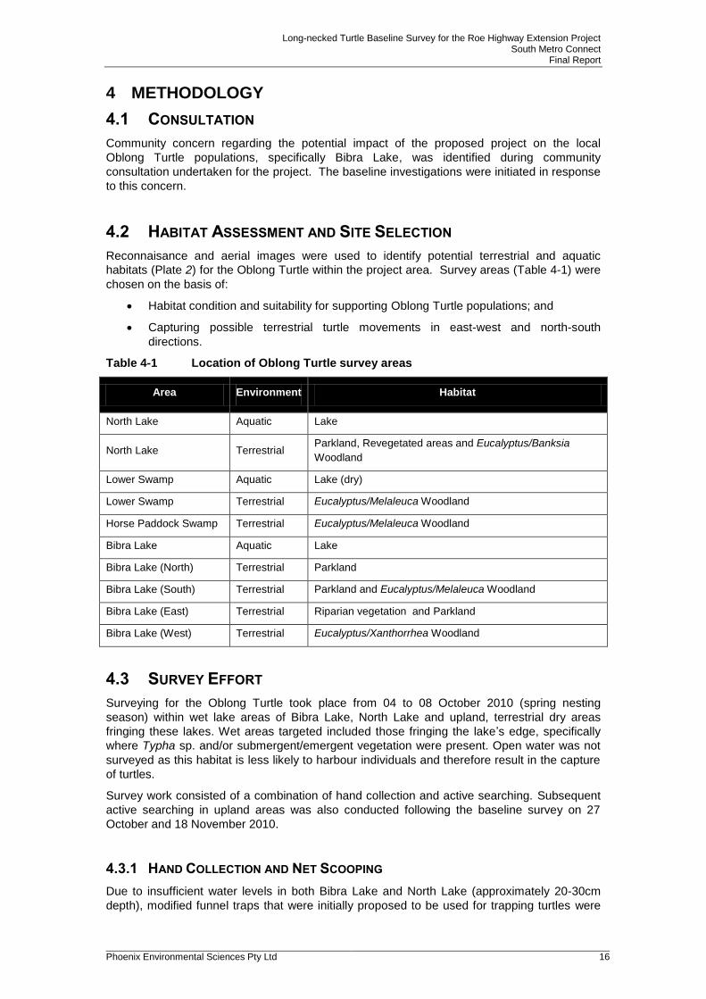
4.2 HABITAT ASSESSMENT AND SITE SELECTION
Reconnaisance and aerial images were used to identify potential terrestrial and aquatic
habitats (Plate 2) for the Oblong Turtle within the project area. Survey areas (Table 4-1) were
chosen on the basis of:
Habitat condition and suitability for supporting Oblong Turtle populations; and
Capturing possible terrestrial turtle movements in east-west and north-south
directions.
Table 4-1 Location of Oblong Turtle survey areas
Area Environment Habitat
North Lake Aquatic Lake
North Lake Terrestrial Parkland, Revegetated areas and Eucalyptus/Banksia
Woodland
Lower Swamp Aquatic Lake (dry)
Lower Swamp Terrestrial Eucalyptus/Melaleuca Woodland
Horse Paddock Swamp Terrestrial Eucalyptus/Melaleuca Woodland
Bibra Lake Aquatic Lake
Bibra Lake (North) Terrestrial Parkland
Bibra Lake (South) Terrestrial Parkland and Eucalyptus/Melaleuca Woodland
Bibra Lake (East) Terrestrial Riparian vegetation and Parkland
Bibra Lake (West) Terrestrial Eucalyptus/Xanthorrhea Woodland
4.3 SURVEY EFFORT
Surveying for the Oblong Turtle took place from 04 to 08 October 2010 (spring nesting
season) within wet lake areas of Bibra Lake, North Lake and upland, terrestrial dry areas
fringing these lakes. Wet areas targeted included those fringing the lake’s edge, specifically
where Typha sp. and/or submergent/emergent vegetation were present. Open water was not
surveyed as this habitat is less likely to harbour individuals and therefore result in the capture
of turtles.
Survey work consisted of a combination of hand collection and active searching. Subsequent
active searching in upland areas was also conducted following the baseline survey on 27
October and 18 November 2010.
4.3.1 HAND COLLECTION AND NET SCOOPING
Due to insufficient water levels in both Bibra Lake and North Lake (approximately 20-30cm
depth), modified funnel traps that were initially proposed to be used for trapping turtles were
Long-necked Turtle Baseline Survey for the Roe Highway Extension Project South Metro Connect
Final Report
Phoenix Environmental Sciences Pty Ltd 17
disregarded. Hand collection and net scooping, using crab scoops was used instead. A total
of 29.4hours was spent surveying via these methods.
Lake Photographs - Bibra Lake
North Lake Lower Swamp (Dry)
Plate 2 Lake habitats surveyed (wet and dry)
4.3.2 ACTIVE SEARCHING
Active searching was used in an attempt to capture upland movement by turtles during the
nesting season survey period. This comprised searches of any observable habitats likely to
support nesting turtles. Such habitats included upland areas of parkland, remnant bushland
and dry lakes/swamps. Where possible, a series of transects 10 meters apart were traversed
on foot to inspect these potential nesting habitats. A total of 23.5hours was spent forgaing.
4.4 BIOLOGICAL PARAMETERS RECORDED
In order to investigate and interpret population dynamics, health and breeding conditions, the
following measurements were taken:

Long-necked Turtle Baseline Survey for the Roe Highway Extension Project South Metro Connect
Final Report
Phoenix Environmental Sciences Pty Ltd 18
Body mass (kg);
Carapace - length, width and depth (cm);
Plastron - length, width and depth (cm);
Ecological Indicators (EI) that provide a relative indication of how well individuals are
managing in their wetland environment e.g the external presence of injuries, scars,
leech infestations, algal cover on carapace, spot softening on carapace, lethargic or
vigourous movement;
Sex; and
Sexual condition: gravid (with eggs).
All captured individuals were marked for recapture identification purposes..
4.5 LIMITATIONS
Limitations of the Oblong Turtle baseline survey are outlined in (Table 4-2).
Table 4-2 Limitations of the Oblong Turtle baseline survey
Limitations Relevant? Comments
Competency / experience of the consultant
carrying out the survey.
No All personnel involved in the field surveys
are competent, experienced zoologists.
Scope (what faunal groups were sampled and
were some sampling methods not able to be
employed because of constraints such as
weather conditions, e.g. pitfall trapping in
waterlogged soils or inability to use pitfall
traps.)
No Scope was adequate. Urban related
constraints determined upfront and worked
around. This was a species-specific
targeted survey.
Proportion of fauna identified, recorded and/or
collected.
No These surveys recorded 23 individuals.
Other Oblong Turtle surveys conducted in
the nearby vicinity recorded more
individuals, however this could be attributed
to longer survey periods. Ongoing surveys
are likely to support this finding.
Sources of information e.g. previously available
information (whether historic or recent) as
distinct from new data.
No Several monitoring programs have been
undertaken in the near vicinity of the project
area (Blue Gum, Booragoon and Piney
Lakes). Findings from these surveys have
supplemented this baseline survey.
Timing/weather/season/cycle. No The timing of the field survey was based on
potentially capturing any seasonal upland
nesting movements.
The proportion of the task achieved and further
work which might be needed.
No The program was implemented as planned
with no further investigations required.
Disturbances (e.g. fire, flood, accidental human
intervention etc.) which affected results of
survey.
No No disturbance occurred during the surveys.
However the project area is located in an
urban bushland, which is subject to
numerous ongoing pressures and historic
degradation.

Long-necked Turtle Baseline Survey for the Roe Highway Extension Project South Metro Connect
Final Report
Phoenix Environmental Sciences Pty Ltd 19
Limitations Relevant? Comments
Intensity (in retrospect, was the intensity
adequate?)
No Survey intensity is adequate for
investigating baseline information on the
resident Oblong Turtle populations within
Bibra Lake and North lake.
Completeness (was relevant area fully
surveyed?)
No All habitat areas specific to the Oblong Turtle
were sampled. Windy and overcast
conditions and murky, shallow lake areas
restricted lake survey sampling. The
relatively small data set has limited the
interpretations presented in this report. This
survey delivered satisfactory results.
Remoteness and/or access problems. No n/a
Availability of contextual (e.g. biogeographic)
information on the region.
No Adequate information exists.
Long-necked Turtle Baseline Survey for the Roe Highway Extension Project South Metro Connect
Final Report
Phoenix Environmental Sciences Pty Ltd 20
5 RESULTS
5.1 LOCAL DISTRIBUTION
There are many previous records of the Oblong Turtle within the project area, surrounding
lakes approximately 3-7km north east and south of the project area (Blue Gum, Booragoon
Piney and Thompsons) and other lakes (Shenton, Perry, and Joondalup, amongst others)
throughout the Perth Metropolitan area.
Anecdotal evidence from conversations with local people and opportunistic findings (turtle
remains) from Phoenix vertebrate surveys and project walkovers within the area suggest that
the Oblong Turtle is a common resident within the project area (Phoenix 2010). Anecdotal
evidence in 2010 suggested that no turtles have been seen crossing roads within the project
area during the current nesting season compared to 2009, where a few turtles were seen. It
was also noted that in the last four years no turtles were seen in horse paddock swamp, as
opposed to previous years.
Further, anecdotal evidence suggests that Oblong Turtles have been known to move into
neighbouring residential properties perhaps in search of nesting sites.
5.2 POPULATION DENSITY ESTIMATES
A total of 23 individuals were captured in Bibra Lake. The southern and northeastern sections
of Bibra Lake captured the most individuals, possibly due to degree of submergent/emergent
vegetation cover fringing these areas. In addition to the 23 turtles captured, 37 turtles were
seen whilst surveying in Bibra Lake that were not able to be captured due to poor water
column visibility and their fast movements. As they were not captured, it was not possible to
determine if they were additional individuals to those recorded.
Based on the aquatic area surveyed (21.6ha or 216,000 m2) and the number of captures, the
minimum population density estimate of Oblong turtles in Bibra Lake is 167.9 or 168 turtles in
157 ha with approximately 1.058 turtles per ha. However, there were no recaptures during
the survey period, suggesting the Bibra Lake population and population density is
considerably larger than that recorded.
No live individuals were seen or captured in North Lake. Four turtle shells were found on the
shoreline of North Lake with no clear evidence of the cause of mortality. Population estimates
of the Oblong turtle in North Lake are unable to be attained based on these results.
5.3 POPULATION DYNAMICS AND STRUCTURE
Of the 23 individuals captured at Bibra Lake, 16 were adult females (69.5%) and seven were
adult males (30.4%). No juveniles were recorded. Within the population sampled female
turtles outnumbered males by more than two to one (2.2:1).
The size structure (carapace length) for both males and females were within normal ranges
based on results from previous surveys. Adult male and female turtles were quite similar in
size with the carpace length in male turtles ranging from 18-23cm (Figure 5-1), with an
average carapace length of 20.5cm, and female turtles 18-25cm (Figure 5-2), with an average
carapace length of 22.3cm (Table 5-1). The standard deviation in carapace length was similar
for both sexes; 1.89 for males and 1.79 for females. There was no evidence of recruitment
(juveniles) within the population sampled. There was also no evidence of reproduction, with
no gravid (with eggs) females captured.

Long-necked Turtle Baseline Survey for the Roe Highway Extension Project South Metro Connect
Final Report
Phoenix Environmental Sciences Pty Ltd 21
Figure 5-1 Size structure of male turtles caught from Bibra Lake
Figure 5-2 Size structure of female turtles caught from Bibra Lake
Table 5-1 Basic population statistics (carapace length) for turtles caught in Bibra
Lake
Minimum Carapace
Length (cm)
Maximum Carapace
Length (cm)
Average Carapace
(mean) Length
(cm)
Standard Deviation
Carapace Length
(cm)
Males 18 23 20.5 1.892969
Females 18 25 22.3 1.793507
5.3.1 CONDITION INDEX
In order to assess the general condition of the turtles captured, a condition index based on
carapace length in relation to body mass was used. A strong positive correlation exists in
male turtles (R² = 0.935) with the minimum body mass (0.770 kg) recorded at 18cm carapace
length and maximum body mass of 1.301 kg recorded at 23cm carapace length (Figure 5-3).
0
1
2
3
18 19 20 20.5 23
Nu
mb
er
of
in
div
idu
als
cau
gh
t
Carapace Length (cm)
Males
0
1
2
3
4
18 20 21 22 22.5 23 23.5 24.5 25Nu
mb
er
of
in
div
idu
als
cau
gh
t
Carapace Length (cm)
Females

Long-necked Turtle Baseline Survey for the Roe Highway Extension Project South Metro Connect
Final Report
Phoenix Environmental Sciences Pty Ltd 22
A moderate positive correlation exists between carapace length and body mass in females (R²
= 0.6082) with the minimum body mass (0.910 kg) recorded at 18cm and maximum 25cm at
1.813 kg (Figure 5-4). The extent of scatter in the graphs may be attributed to the relatively
small sample size. Two females and one male were shedding plates (12.5% and 14.2% of the
population respectively) which is a general indication of growth.
Figure 5-3 Linear regression comparing carapace length to body mass for male
turtles caught in Bibra Lake
Figure 5-4 Linear regression comparing carapace length to body mass for female
turtles caught in Bibra Lake
R² = 0.9351
0.000
0.200
0.400
0.600
0.800
1.000
1.200
1.400
18 18.5 19 19.5 20 20.5 21 21.5 22 22.5 23
Bo
dy m
ass (
kg
)
Carapace length (cm)
R² = 0.6082
0.000
0.200
0.400
0.600
0.800
1.000
1.200
1.400
1.600
1.800
2.000
18 19 20 21 22 23 24 25
Bo
dy m
ass (
kg
)
Carapace length (cm)

Long-necked Turtle Baseline Survey for the Roe Highway Extension Project South Metro Connect
Final Report
Phoenix Environmental Sciences Pty Ltd 23
5.3.2 ECOLOGICAL INDICATORS
Of the 23 turtles captured 12 turtles (52.1%) had ecological indicators (EI’s) present, with algal
growth on the carapace the most common EI. Generally males had the greatest degree of EI’s
present, with 85% displaying EI’s compared with 43% of females (Table 5-2). In total,
approximately 57.1% of males and 25.0% of females had a thin layer of algal coverage
greater than 80.0%.
One male and two females had a medium layer of algal growth present with the male
considered to be in a satisfactory condition, despite recording a combination of two ecological
indictors (algal and fungal growth) (Plate 3). Only one male had 20% algal coverage on his
carapace. Of the females, 56.2% had clean carapaces, whereas only one of seven males had
a clean carapace (14.3%). Consequently, the population is considered to be in good to very
good condition.
Table 5-2 Ecological Indictors of male and female turtles caught in Bibra Lake
Sex
No Algal Coverage %
Thin layer algal coverage (20-79% coverage)
Thin layer algal coverage (greater than 80% coverage)
Medium layer algal coverage (greater than 80% coverage) Fungal Growth
Total number of individuals with Ecological Indicators present (%)
Male 14.2 14.2 57.1 14.2 14.2 85
Female 56.2 n/a 25 12.5 n/a 43
Plate 3 Algal and fungal growth present on an individual.
5.4 MOVEMENTS
5.4.1 WEATHER CONDITIONS
A study by Clay 1981 showed that a decrease in barometric pressure caused by an
approaching low pressure system was known to initiate the movement of females to nest
sites. The lowest barometric pressure recorded during the month of October occured on the
1st, 9-10
th and 27
th of the month of which none oocurred within the survey period (Figure 5-5).
Rainfall followed some of these low pressure systems on the 10-11th and 28-29
th. Clay (1981)

Long-necked Turtle Baseline Survey for the Roe Highway Extension Project South Metro Connect
Final Report
Phoenix Environmental Sciences Pty Ltd 24
also found that females move to nest sites when maximum daily temperatures remain above 17.5°C, however maximum temperatures above 25°C may hinder movements/observations
due to increased desiccation and potential mortality (Figure 5-6). During the survey period, daily maximum temperatures were consistently above 17.5°C and on two of the survey days
were above 25°C. No upland nesting movements were recorded during the survey period.
Data sourced: Bureau of Meterology, January 3rd 2011.
Figure 5-5 Barometric pressure and rainfall recorded during the month of October
2010
0
1
2
3
4
5
6
7
8
9
995
1000
1005
1010
1015
1020
1025
1030
1035
1 3 5 7 9 11 13 15 17 19 21 23 25 27 29 31
Rain
fall (
mm
)
Baro
metr
ic P
ressu
re (
hP
a)
Date in October 2010
Survey Period Rainfall 9am 3pm

Long-necked Turtle Baseline Survey for the Roe Highway Extension Project South Metro Connect
Final Report
Phoenix Environmental Sciences Pty Ltd 25
Data sourced: Bureau of Meterology, January 3rd 2011.
Figure 5-6 Minimum and maximum temperatures recorded during the month of
October 2010
5.4.2 ACCESSS TO SUITABLE NESTING HABITAT
A number of factors have been identified as limiting access to potentially suitable upland
nesting habitat for the Oblong Turtle within the survey area. These include retaining walls,
steep lake side banks, thick non-native grasslands and the presence of dense Typha sp.
fringing wetlands.
Bibra Lake
The retaining wall situated in the central, western shore of Bibra Lake was identified as
restricting turtle movements into bushland areas directly west of the lake. Turtles may enter
the southern extent of this bushland although the distance to reach this particular upland area
is approximately 150m from the lake itself and based on previous literature turtles are unlikely
to travel those distances (Clay 1981).
In the southern end of the lake, banks are steep in sections with pockets of thick Typha sp.
and other fringing lakeside vegetation potentially preventing turtles from accessing upland
areas beyond the lake. Oblong turtles are generally good climbers on angled slopes,
particularly surfaces that are covered with lawn or even over shrubs (G Kuchling 2010 pers.
comm., November 26). It is however uncertain if they will climb the steep banks (>45º)
situated in this area. Some areas in this southern section have gently sloping banks allowing
potential access to the dry, open swamp area south-west of the lake (south of Adventure
World) and also the adjacent parkland.
Generally, any potential northern movements from Bibra Lake to Horse Paddock Swamp are
restricted by the 30-160m wide, dense patch of Typha fringing the northern tip of Bibra Lake.
Oblong turtles are unlikely to cross over these dense areas, especially if there are no
openings, clearings or animal tracks present (G Kuchling 2010 pers. comm., November 26).
Only one small, open, relatively flat section (north-eastern corner) exists which may allow
turtles to potentially cross to upland areas east of Horse Paddock Swamp.
0
5
10
15
20
25
30
35
40
1 2 3 4 5 6 7 8 9 10 11 12 13 14 15 16 17 18 19 20 21 22 23 24 25 26 27 28 29 30 31
Tem
pera
ture
(C
°)
Date in October 2010
Survey Period Daily maximum temperatureDaily minimum temperature

Long-necked Turtle Baseline Survey for the Roe Highway Extension Project South Metro Connect
Final Report
Phoenix Environmental Sciences Pty Ltd 26
North Lake
Thick non-native grassland and riparian vegetation/sedges fringing the north-western corner
of the lake restrict any potential movement to upland areas. The steep banks situated in the
central, western side of the lake also restrict westward movements.
Some sections in the south-western and north-eastern upland areas of the lake may be
suitable for nesting. These areas are easily accessible from the lake (no thick fringing
grasslands preventing access) and they consist of open revegetated patches or pockets of
Eucalyptus/Banksia woodlands on loose sand.
Horse Paddock Swamp
Horse Paddock Swamp is dense with non-native grasses, with a few bare sand patches
present. It is unlikely that turtles will nest in this area or move from Bibra Lake into this area
based on their habitat requirements for open, sandy areas, void of dense vegetation. It is also
unlikely that turtles will move from North Lake into this area due to the large distances
required to traverse (over 215m) (Clay 1981).

Long-necked Turtle Baseline Survey for the Roe Highway Extension Project South Metro Connect
Final Report
Phoenix Environmental Sciences Pty Ltd 27
6 DISCUSSION AND CONCLUSION
Population estimates for the Oblong Turtle within Bibra Lake are approximately 168 turtles in
157 ha which amounts to approximately 1.058 turtles per ha. This suggests that a rather large
area of over 1ha needs to be surveyed before one turtle is expected to be caught. The
relatively fast maneuverability/mobility of this species may contribute to this result.
The minimum population size of Oblong Turtles in Bibra Lake is twenty-three individuals (16
adult females and 7 adult males) with an additional 37 individual’s seen within the lake but not
captured. Based on the lack of recaptures, it is likely that the size of this population is
considerably larger than that recorded. Further surveys could potentially clarify this
assumption.
The presence of adult turtles suggests that the long-term viability of the Bibra Lake population
is possible, but is also dependant on other habitat requirements such as access to suitable
upland nesting habitats, terrestrial buffers, adequate foraging areas and basking and
aestivation sites. The lack of juveniles seen and caught may be attributed to their elusive
nature and ability to hide easily within the water and amongst the submergent/emergent lake
vegetation. The change in survey methodologies from modified funnel traps to hand
collection/net scooping as a result of low lake water levels has contributed to the relatively
small sample size and the lack of juveniles captured.
Population estimates for the Oblong turtle in North Lake could not be determined based on
the lack of captures resulting from this survey effort. This may be attributed to the survey
technique (net scooping) within this shallow water body
The size structure in male and female carapace sizes (cm) was comparable to previous turtle
surveys in the Perth Metropolitan area (Giles et al 2008; Giles 2009; Guyot and Kuchling
1998). Correlation analysis found strong and moderate, positive correlations between
carapace length (cm) and body mass (kg) in male and female sexes, respectively.
Of the sampled population, 52.1% recorded the presence of ecological indicators, with males
recording the highest number of indicators present. Overall the data and observations suggest
that the Oblong turtles of Bibra Lake are in good to very good condition.
Although the survey was timed to record upland nesting movements, none were observed. It
is likely that the weather was too warm during the survey with movements potentially
occurring later in the season based on the subsequent weather conditions that occurred in
lateOctober 2010.
Limited access to areas of suitable upland nesting habitat may be a risk to the viability of the
turtle population in the long-term. Access is restricted in parts of Bibra Lake and North Lake
by retaining walls, steep lake side banks, thick non-native grasslands and the presence of
dense Typha thickets fringing the shoreline in some areas. Management of both lakes should
consider the modification (or removal) of sections of the existing retaining walls to create
gently sloping banks allowing easy access for turtles into upland areas. Management of non-
native grasses and clearing of small pockets of Typha would also increase access into these
terrestrial nesting habitats.
Threatening processes such as increased fragmentation of upland habitats, weed invasion,
road mortality and predation remain within the project area and will continue to limited
dispersal and disrupt breeding success and recruitment.
The potential impacts from the proposed Roe Highway Extension on the Oblong Turtle within
North Lake are negligible and within Bibra Lake negligible to low. The current, limited access
to upland nesting areas, particularly the area south of Horse Paddock Swamp may already
inhibit any turtle movements into this area. The proposed alignment may cause further habitat
loss and fragmentation of upland habitat in this particular area, however the extent of this is
minor.
If water quality in Bibra Lake is affected by the project, there may be some effects on the food
chains for this species.
Long-necked Turtle Baseline Survey for the Roe Highway Extension Project South Metro Connect
Final Report
Phoenix Environmental Sciences Pty Ltd 28
7 REFERENCES
Burbidge, A. A. and Kuchling, G. (2003). Western Swamp Tortoise Recovery Plan Wildlife
Management Program, Department of Conservation and Land Management. 3rd edition.
Clay, B. T. (1981). Observations on the breeding biology of the longnecked tortoise,Chelodina
oblonga. Journal of the Royal Society of Western Australia 4(1): 27-32.
DEC (2009). Fauna notes No. 37 Oblong turtle and exotic red-eared slider turtle, Department
of Environment and Conservation.
EPA (2002). Position Statement No. 3 Terrestrial Biological Surveys as an element of
Biodiversity Protection. Perth, Environmental Protection Authority.
EPA (2004). Guidance for the Assessment of Environmental Factors No. 56: Terrestrial Fauna
Surveys for Environmental Impact Assessment in Western Australia. Perth, Environmental
Protection Authority: 40.
Giles, J. C. (2009). Baseline study of the longnecked, freshwater Turtles (Chelodina oblonga)
at Lake Joondalup, Friends of Yellagonga.
Giles, J. C., Kuchling, G. and Davis, J. A. (2008). Populations of the snakenecked turtle
Chelodina oblonga in three suburban lakes of Perth, Western Australia Urban herpetology,
Mitchell, J.C., Jung Brown, R.E. and Bartholomew (eds) Herpetological Conservation No. 3:
275- 283.
Gole, C. (2006). The Southwest Australia Ecoregion: Jewel of the Australian Continent,
Southwest Australia Ecoregion Initiative.
Guyot, G. and Kuchling, G. (1998). Some ecological aspects of populations of Oblong Turtles
(Chelodina oblonga) in the suburbs of Perth (Western Australia). Le Bourget Du Lac, edited
by C. Miaud, and R. Guyetant (Societas Europaea Herpetologica, France): 173-181.
Heddle, E. M., Loneragan, O. W. and Havel, J. J. (1980). Land Use in the Darling System,
Western Australia, Department of Environment and Conservation.
How, R. A. a. D., J. (2000). Ground vertebrate fauna of Perth’s vegetation remnants: impact of
170 years of urbanization. Pacific Conservation Biology. 6: 198-217.
Kitchener, D. J., Chapman, A., Dell, J., Muir, B.G. and Palmer, M. (1978). Mammals of the
northern Swan Coastal Plain. In Faunal Studies of the Northern Swan Coastal Plain - a
Consideration of Past and Future Changes. Perth, Western Australian Museum: pp. 54-92.
Kuchling, G. (1988). Gonadal cycles of the Western Australian long-necked turtles Chelodina
oblonga and Chelodina steindachneri (Chelonia: Chelidae). Records of the Western
Australian Museum 14: 189-198.
Kuchling, G. (1989). Assessment of ovarian follicles and oviductual eggs by ultra-sound
scanning in live freshwater turtles, Chelodina oblonga. Herpetologica 45(1): 89-94.
Mitchell, D., Williams, K. and Desmond, A. (2002). Swan Coastal Plain 2 (SWA2 - Swan
Coastal Plain subregion) in A biodiversity audit of Western Australia’s 53 Biogeographical
subregions in 2002. Perth, Department of Conservation and Land Management. 2003.
Phoenix Environemntal Sciences (2010) Vertebrate Fauna Survey for the Roe Highway
Extension Project (Interim report) prepared for South Metro Connect. Perth, Western
Australia.

Long-necked Turtle Baseline Survey for the Roe Highway Extension Project South Metro Connect
Final Report
Phoenix Environmental Sciences Pty Ltd 29
Thackway, R. and Cresswell, I. D. (1995). An Interim Biogeographic Regionalisation for
Australia, Australian Nature Conservation Agency, Reserve System Unit,Canberra.
Tingay, A. A. (1998). A Strategic Plan for Perth’s Greenways. Prepared for Ministry for
Planning.
WAM (2010) Vertebrate biodiversity in Perth's urban bushlands. 05/08/2010).
WAPC (2000a). Bush Forever: Volume 1: Polices, Principles and Processes Perth, Western
Australian Planning Commission. 1.
Wilson, S. and Swan, G. (2008). A complete guide to reptiles of Australia
Sydney, New Holland Publishers.

Long-necked Turtle Baseline Survey for the Roe Highway Extension Project South Metro Connect
Final Report
Phoenix Environmental Sciences Pty Ltd 30
APPENDIX 1 TURTLES RECORDED IN BIBRA LAKE DURING THE OCTOBER 2010 SURVEY

Long-necked Turtle Baseline Survey for the Roe Highway Extension Project South Metro Connect
Final Report
Phoenix Environmental Sciences Pty Ltd 31
Date Number Sex Sexual
Condition: Gravid
Body Mass(kg) Carapace
Length (cm) Carapace Width (cm)
Carapace Depth (cm)
Plastron Length
(cm)
Plastron Width (cm)
Plastron Depth (cm)
Health Ecological Indicators
Survey areas (Bibra Lake)
Notes
4/10/2010 1 Female No 1.200 23.5 12.5 1.5 18 7 3.5 Very Good
South 10 tutles seen but
not caught
4/10/2010 2 Female No 1.000 22 15 1.4 16.5 11.6 3.5 Very Good shedding plates South
5/10/2010 3 Male n/a 0.910 19 11.5 1 14.5 9.5 3.3 Good thin layer of algae
cover (100%) South
4/10/2010 4 Male n/a 0.900 20 11.6 1.5 15.5 6 3 Good thin layer of algae
cover (20%) South
5/10/2010 5 Male n/a 0.770 18 10.5 1 13.4 9 3 Good shedding plates,
thin layer of algae cover (80%)
South
7/10/2010 6 Female No 1.398 22.5 13 1.5 17 7 3.4 Good thin layer of algae
cover (80%) South
7 others seen, but not caught
7/10/2010 7 Male n/a 965.000 20.5 11.5 1 15 6 3 Good thin layer of algae
cover (80%) East
7/10/2010 8 Male n/a 1.195 23 13 1.2 17 7 3.4 Good thin layer of algae
cover (80%) East
4/10/2010 9 Female No 0.900 20 12.5 1 15.6 11.5 3.8 Good thin layer of algae
cover (100%) South
4/10/2010 10 Female No 1.000 22.5 12.5 1.5 16.5 7 3.7 Good shedding plates,
thin layer of algae cover (100%)
South 12 tutles seen but
not caught
7/10/2010 11 Female No 1.135 23 11 1.4 17 7 3 Very Good Clean plates North East
7/10/2010 12 Female No 1.105 21 12 1.2 15 6.5 3.4 Very Good Clean plates North East
7/10/2010 13 Female No 1.270 22 12.5 1.2 16.5 7 3 Very Good Clean plates North East
7/10/2010 14 Female No 0.910 18 11 1.1 15 6.1 2.9 Very Good Clean plates North East

Long-necked Turtle Baseline Survey for the Roe Highway Extension Project South Metro Connect
Final Report
Phoenix Environmental Sciences Pty Ltd 32
Date Number Sex Sexual
Condition: Gravid
Body Mass(kg) Carapace
Length (cm) Carapace Width (cm)
Carapace Depth (cm)
Plastron Length
(cm)
Plastron Width (cm)
Plastron Depth (cm)
Health Ecological Indicators
Survey areas (Bibra Lake)
Notes
7/10/2010 15 Female No 1.525 23.5 13.5 1 18 7.5 3.5 Very Good Clean plates North East
7/10/2010 16 Female No 1.721 24.5 14.1 1.2 18.5 7.9 3.7 Good thin layer of algae
cover (80%) South
8/10/2010 17 Female No 1.813 25 12.5 1.4 17.5 7 4 Good Medium layer
algae cover (80%) South
8 other seen, but not caught
8/10/2010 18 Male n/a 1.301 23 13 1.1 16.5 6.9 3.5 Satisfactory Fungal growth, Medium layer
algae cover (80%) South
8/10/2010 19 Female No 1.360 22 13 1.5 17.5 7.3 3.3 Very Good
South
8/10/2010 20 Female No 1.545 24.5 13 1.3 18 7.5 3.5 Very Good
North East
8/10/2010 21 Female No 1.321 21 13 1 16 7 3.5 Very Good
North East
8/10/2010 22 Male n/a 0.921 20 13 1.3 15.5 6.5 3.5 Very Good
East
8/10/2010 23 Female No 1.269 23 12 1.7 17.5 6.5 3.5 Good Medium layer
algae cover (80%) North East

Top Related