Ws sde tab_relslides
24
CPPresenter: Keldah Hedstrom ESRI Redlands, California Understanding ArcSDE Table Relationships Understanding ArcSDE Table Relationships
-
Upload
bangalore-techie -
Category
Technology
-
view
208 -
download
0
Transcript of Ws sde tab_relslides

The presentation will begin at 3PM Pacific Time
Crossword PuzzleClue
Presenter: Keldah Hedstrom ESRI Redlands, California
Understanding ArcSDE Table Relationships
Understanding ArcSDE Table Relationships

Copyright © 2002 ESRI. All rights reserved.
Seminar OverviewTopics
Overview of table relationships in ArcGISChoosing a join type Optimizing table relationships
FormatSlide shows followed by software demonstrationsEach topic followed by brief review and question and answer period
Copyright © 2002 ESRI. All rights reserved.
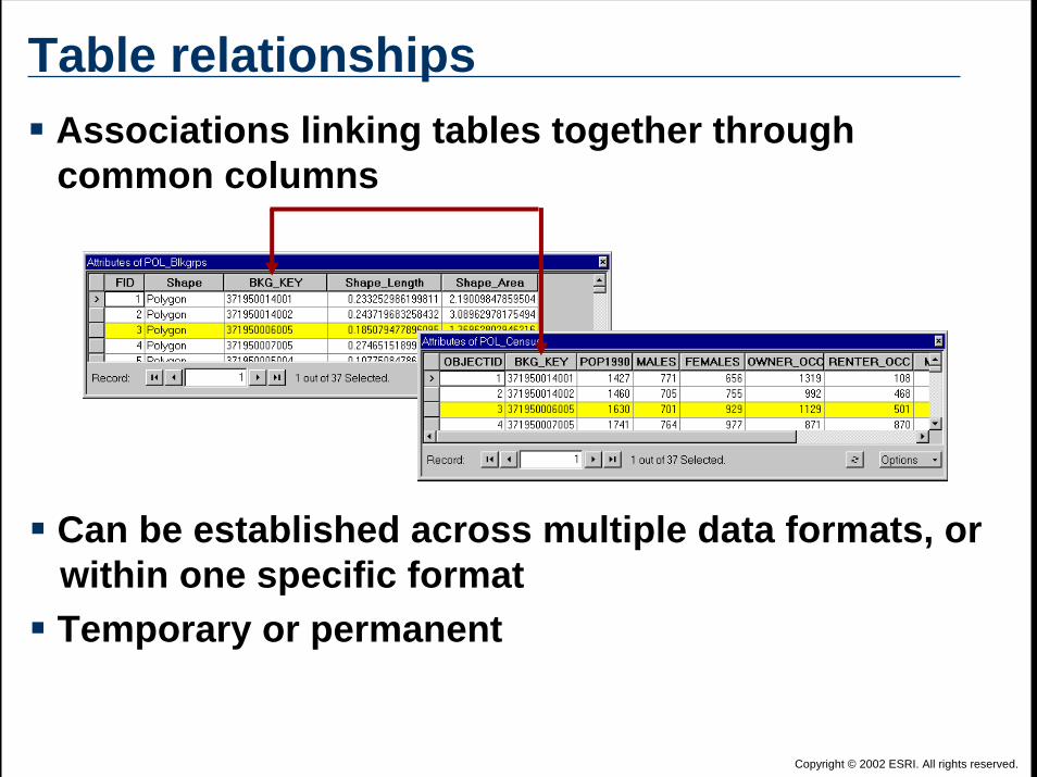
Table relationships
Can be established across multiple data formats, or within one specific formatTemporary or permanent
Associations linking tables together throughcommon columns

Copyright © 2002 ESRI. All rights reserved.
Relationship types in ArcGISArcMap
JoinsRelatesRelationship classes
ArcIMS<QUERY> tag<SPATIALQUERY> tag
ArcSDESpatial and non-spatial views

Copyright © 2002 ESRI. All rights reserved.
Joining tablesColumns appended together virtually, but source files remain separate
Temporary association created in ArcMap
Applied to multiple data formats

Copyright © 2002 ESRI. All rights reserved.
Tables not appended together
Tables viewed separately
Relating tables
Manually update selectionsTemporary association created in ArcMapApplied to multiple data formats
Copyright © 2002 ESRI. All rights reserved.
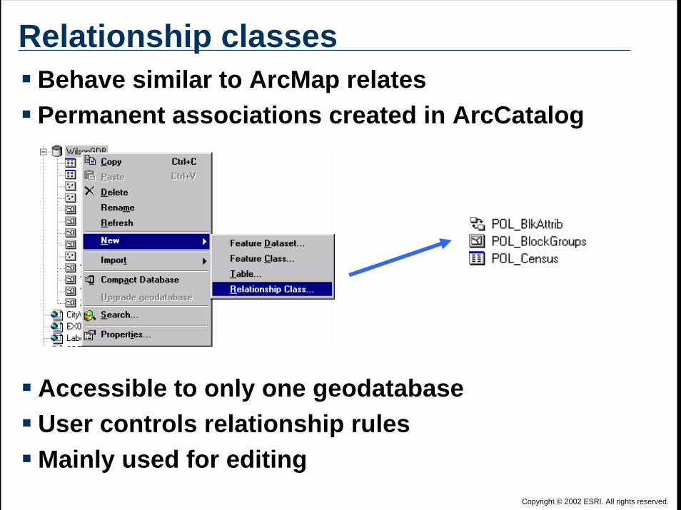
Relationship classes
Accessible to only one geodatabaseUser controls relationship rulesMainly used for editing
Behave similar to ArcMap relatesPermanent associations created in ArcCatalog

Copyright © 2002 ESRI. All rights reserved.
Joining and selecting dataSQL: Structured Query Language
Used to query multiple database tables to retrieve dataCan be used to select features or table records in any data format supported by ArcGIS
SELECT wilson.coffee.NAME, wilson.coffee.Coffee_ID, wilson.coffee.Own_ID, wilson.owner.Own_ID, wilson.owner.OWNER_NAMEFROM wilson.coffee, wilson.ownerWHERE wilson.coffee.Own_ID = wilson.owner.Own_ID
SELECT, FROM, and WHERE clauses

Copyright © 2002 ESRI. All rights reserved.
ArcIMS joins
<SPATIALQUERY where=”DB.CITY.FIPS = DB.SCHOOLS.FIPS”jointables=”DB.SCHOOLS” />
<QUERY where=”FOO.PARCELS.ZONE_CODE = FOO.ZONING.ZONE_CODE” jointables=”FOO.ZONING” />
Created using ArcXMLUse <SPATIALQUERY> or <QUERY> tags
Used with SQL WHERE statement attributeUsed with jointables attribute
Across only one data formatShapefile DBF to DBF tableArcSDE feature class to ArcSDE table

Copyright © 2002 ESRI. All rights reserved.
ArcSDE views
Read-onlyMust be created on non-versioned tables
Associate multiple ArcSDE tables Permanent SQL query stored in database
View including spatial column behaves like feature classCan change query to get different data
sdetable -o create_view -T road_view –troad_geometry,road_info -c shape,name -w”road_geometry.road_id = road_info.road_id”-D wilson -u myusername -p mypassword
Syntax to create a spatial view

Copyright © 2002 ESRI. All rights reserved.
Software Demonstration

Copyright © 2002 ESRI. All rights reserved.
Topic Review and Q & ATypes of table relationships in ArcGIS
JoinsRelatesRelationship classesSQL statementsArcIMS joinsArcSDE views

Copyright © 2002 ESRI. All rights reserved.
Inner join
ArcMap: “Keep only matching records”
SELECT *FROM parcelsINNER JOIN zoningON parcels.zone_code = zoning.zone_code
SQL join syntax
PARCELSZone_Code
RES2RES2RES1RES1RES2RES1RES2COM
ZONINGZone_Code
RES1RES2
INNER JOINZone_Code
RES2RES2RES1RES1RES2RES1RES2
PARCELS + ZONING =
ArcSDE view default type of join

Copyright © 2002 ESRI. All rights reserved.
Outer join
Left Outer join supported by ArcMap, and is default join
ArcMap join: “Keep allrecords (default)”
ArcSDE views support:Left Outer joinRight Outer joinFull Outer join
SELECT *FROM parcelsLEFT OUTER JOIN zoningON parcels.zone_code =
zoning.zone_code
SQL join syntax

Copyright © 2002 ESRI. All rights reserved.
Inner and Outer joins
Inner Join 2 23 3
Left Outer Join 12 23 3
Right Outer Join 2 23 3
4
Full Outer Join 12 23 3
4
Source DataTable 1 Table 2
12 23 3
4
ArcMap joinsArcSDE views

Copyright © 2002 ESRI. All rights reserved.
CardinalityDetermines how many features in a feature class are related to how many records in an attribute table
One-to-Many Many-to-ManyMany-to-OneOne-to-One
One parcelhas one owner
Many parcelshave many owners
Many parcelshave one owner
One parcelhas many owners
Must follow rules for connecting tables together

Copyright © 2002 ESRI. All rights reserved.
Supported ArcGIS cardinalityDifferent types of relationships have different cardinality choices
Join Relate RelationshipClass
ArcSDE View ArcXML
1 to 1 x x x x x1 to M x x x * x *
M to 1 x x x x
M to M x x x * x *Car
dina
lity
Type of Relationship
* Not supported in ArcMap

Copyright © 2002 ESRI. All rights reserved.
Software Demonstration

Copyright © 2002 ESRI. All rights reserved.
Topic Review and Q & ADifferent options available for joining with ArcMap and ArcSDE Join types
Inner joinOuter join: Left, Right, and Full
CardinalityOne-to-one, one-to-many, many-to-one, many-to-many

Copyright © 2002 ESRI. All rights reserved.
Joins processed by ClientTypes
ArcMap join with “Keep all records” optionArcMap join across connectionsArcMap relateGeodatabase relationship class
ClientClient
RDBMS
ArcSDE
BenefitsEnables advanced functionality
Joins across database connections
DrawbacksPotentially slow

Copyright © 2002 ESRI. All rights reserved.
Joins processed by ServerTypes
ArcMap join with:“Keep only matching records” optionSame database connection
ArcIMS <QUERY> and <SPATIALQUERY>ArcSDE view
AND
Client
RDBMSRDBMS
ArcSDE
BenefitsBest performance
Use DBMS join algorithmsServer hardware typically faster
DrawbacksMay require advanced knowledgeor additional DBMS privileges

Copyright © 2002 ESRI. All rights reserved.
Use indexesQuickly search attribute or spatial data Create with:
ArcCatalogArcSDE
sdetable –o create_index
DBMS tools Recommendations for creating indexes
Always index join columnsIndex join columns on both tables

Copyright © 2002 ESRI. All rights reserved.
Create DBMS statisticsEnable DBMS to choose best execution plan
Stores number of rowsStores number of unique values
Create with:ArcCatalog
Right-click and choose AnalyzeArcSDE
sdetable -o update_dbms_statistics
DBMS Varies depending on DBMS
Update when data changes significantlyLoading dataCompressing a versioned database

Copyright © 2002 ESRI. All rights reserved.
Topic Review and Q & AOptimize table relationships by:
Joining on client vs. server Using indexesCreating DBMS statistics