WOODGATE HOUSE, AYLSHAM, GEOPHYSICS PHASE 4 · PDF filewoodgate house, aylsham, geophysics...
20
WOODGATE HOUSE, AYLSHAM, GEOPHYSICS PHASE 4 DETAILED MAGNETOMETER SURVEY Report Number: 1139 February 2017
Transcript of WOODGATE HOUSE, AYLSHAM, GEOPHYSICS PHASE 4 · PDF filewoodgate house, aylsham, geophysics...

WOODGATE HOUSE, AYLSHAM, GEOPHYSICS
PHASE 4
DETAILED MAGNETOMETER SURVEY
Report Number: 1139 February 2017
© Britannia Archaeology Ltd 2015 all rights reserved Report Number: 1139
WOODGATE HOUSE, AYLSHAM, GEOPHYSICS PHASE 4
DETAILED MAGNETOMETER SURVEY
Prepared for: Suffolk County Council Archaeology Services
Bury Resource Centre Hollow Road
Bury St Edmunds IP32 7AY
By:
Matthew J. Baker MA, BA (hons)
Britannia Archaeology Ltd Unit 2, The Old Wool Warehouse
St Andrews Street South Bury St Edmunds
Suffolk IP33 3PH
T: 01449 763034 [email protected] www.britannia-archaeology.com
Registered in England and Wales: 7874460
September 2016
Site Code - NGR
618200 326000
Event Number -
Planning Ref.
n/a
OASIS
pending
Approved By:
Date
February 2017

Woodgate House, Aylsham, Geophysics Phase 4 Detailed Magnetometer Survey
Project Number 1167
3 ©Britannia Archaeology Ltd 2017 all rights reserved Report Number: 1139
DISCLAIMER
The material contained within this report was prepared for an individual client
and solely for the benefit of that client and the contents should not be relied
upon by any third party. The results and interpretation of the report cannot be
considered an absolute representation of the archaeological or any other
remains. Britannia Archaeology Ltd will not be held liable for any error of fact
resulting in loss or damage, direct, indirect or consequential, through misuse
of, or actions based on the material contained within by any third party.

Woodgate House, Aylsham, Geophysics Phase 4 Detailed Magnetometer Survey
Project Number 1167
4 ©Britannia Archaeology Ltd 2017 all rights reserved Report Number: 1139
CONTENTS
1.0 INTRODUCTION
2.0 SITE DESCRIPTION
3.0 ARCHAEOLOGICAL BACKGROUND
4.0 PROJECT AIMS
5.0 METHODOLOGY
6.0 RESULTS
7.0 CONCLUSIONS
8.0 PROJECT ARCHIVE AND DEPOSITION
9.0 ACKNOWLEDGEMENTS
BIBLIOGRAPHY
Figure 1 General Location Plan 1:5000
Figure 2 Grid Plan 1:2000
Figure 3 Grayscale Data Unprocessed 1:2000
Figure 4 Trace Plot 1:2000
Figure 5 Grayscale Processed 1:2000
Figure 6 Interpretation Plan 1:2000

Woodgate House, Aylsham, Geophysics Phase 4 Detailed Magnetometer Survey
Project Number 1167
5 ©Britannia Archaeology Ltd 2017 all rights reserved Report Number: 1139
1.0 INTRODUCTION From 2014 to 2017 Britannia Archaeology Ltd (BA) undertook four phases of geophysics, with the latest phase being run as a community project, on land at Woodgate House, Cawston Road, Aylsham, Norfolk (NGR 618200 326000). 2.0 SITE DESCRIPTION
The site is located 1km to the south west of Aylsham town centre, between Cawston
Road and Stonegate Lane. It lies within the parish boundary of Aylsham and the
Broadland District of Norfolk. The site straddles the east-west orientated valley of Mary’s
Beck, which is a tributary of a larger stream called The Mermaid. Mary’s Beck has its
source 40m north of the western boundary of the site, and the size of the valley suggests
it was more substantial at some point in the past. The northern half of the site slopes
down to the south; the southern half slopes down to the north. The centre of the site is
situated just below 30m aOD and the far northern and south-western extents just touch
35m aOD.
The north-east corner of the site is currently used for arable farming and a large kitchen
garden is present north of the main house. The site is bounded to the north and west by
Cawston Road. A new housing development is under construction to the north, but the
western boundary remains woodland. Stonegate (Lane) forms the eastern boundary with
agricultural fields beyond, and the southern boundary comprises a chain-link fence and
hedgerow with agricultural fields beyond.
The underlying bedrock is described as Wroxham Crag Formation sand and gravel,
sedimentary bedrock formed up to 2 million years ago during the Quaternary Period
when the local environment was dominated by swamps, estuaries and deltas periodically
inundated by the sea (BGS, 2016).
The superficial deposits are described as mid-Pleistocene glaciofluvial deposits of sand
and gravel when the local environment was dominated by ice age conditions (BGS,
2016).

Woodgate House, Aylsham, Geophysics Phase 4 Detailed Magnetometer Survey
Project Number 1167
6 ©Britannia Archaeology Ltd 2017 all rights reserved Report Number: 1139
3.0 ARCHAEOLOGICAL BACKGROUND
A full desk-based assessment was undertaken for the site in November 2014 by Britannia
Archaeology, Land at Woodgate House, Cawston Road, Aylsham, Norfolk – Desk-Based
Assessment, (Adams, MC. 2014: R1069). The summary of this investigation was as
follows:
The assessment has identified a very high potential for Roman remains relating to high
status villa settlement activity on the site. The quantity and quality of Roman material
recovered by Mr Purdy over the years, suggests the presence of a substantial, high
status villa complex, probably focused in the area of the Kitchen Garden and immediate
surroundings, with outlying industrial areas to the north-east and agricultural areas to
the south and north.
The potential for all other periods is considered to be low, however the site appears to lie
on the periphery of the town’s medieval field system and so the potential here is
moderate. It has also been subject to significant landscaping as well as farming activity
during the post-medieval period so the potential for features or finds dating to this
period is considered high.
The wider area shows evidence of occupation activity since the Neolithic period with
significant settlement activity identified to the north-west of Aylsham in the Bronze Age
(outside the search area), at Brampton to the south-east in the Roman period, and in
Aylsham itself from the Anglo-Saxon period onwards.
The cartographic sources suggest significant remodelling of the plots around Woodgate
House between the late 18th and late 19th century AD. A system of old track ways are
clearly visible in both the cartographic sources and the geophysics results in the southern
half of the site.
4.0 PROJECT AIMS
The aims of this phase of the Aylsham Roman Project are to undertake non-intrusive
geophysical survey to expand on previous surveys, conducted in the north-east and

Woodgate House, Aylsham, Geophysics Phase 4 Detailed Magnetometer Survey
Project Number 1167
7 ©Britannia Archaeology Ltd 2017 all rights reserved Report Number: 1139
south-east fields, to further define magnetic anomalies identified in previous geophysical
surveys.
• To further enhance our understanding of the archaeological potential of the site;
• To characterise the development, phasing, spatial organisation, character,
function, and the nature of social, economic and industrial activities on site;
• Place the evidence for Roman activity at the site in context with known remains of
a similar date around Aylsham and the wider region;
• Undertake analysis of the survey data leading to appropriate forms of public
dissemination.
5.0 METHODOLOGY
The survey grid was be set out to the Ordnance Survey OSGB36 datum to an accuracy of
±0.01m using a Leica Viva Glonnass Smart Rover GS08.
A Bartington Dual Grad 601-2 fluxgate gradiometer was used to undertake the survey,
because of its high sensitivity and rapid ground coverage. The soils and underlying
geology are receptive to magnetometer survey, but good results are heavily dependent
on the contrast between the fills of a feature (with humic and charcoal rich deposits
providing the best results) and the relative weakness of the local magnetic background
field.
Only minimal processing of the datasets has been undertaken, data processing allows for
the correction of errors introduced during the survey and instrument errors. The survey
data has been processed using TerraSurveyor software V3, where the following data
processes were applied:
Destripe: Removes striping effects from the raw data caused by discrepancies
between different sensors and walking directions caused by alternate zig-zag
traverses.
Destagger: Corrects the displacement of anomalies caused by alternate zig-zag
traverse.
Clip: The range of the data can be set to specified maximum and minimum values
in order to improve the contrast of weaker anomalies within the data.

Woodgate House, Aylsham, Geophysics Phase 4 Detailed Magnetometer Survey
Project Number 1167
8 ©Britannia Archaeology Ltd 2017 all rights reserved Report Number: 1139
Compress: Weak anomalies were further enhanced by applying an arctangent
weighing to the data.
Grad. Shade: The overall appearance of the data was improved
The raw and processed greyscale plots have been produced for comparison. An XY trace
plot consisting of the processed data will be used in combination with raw and processed
greyscale data. An interpretation plan characterising the anomalies has been produced
based on the evidence collated from the greyscale and XY trace plots.
6.0 RESULTS (Figs. 2-6)
The unprocessed data from the magnetic surveys are shown in figure 2. Figure 2 is
displayed as a greyscale plot with the maximum and minimum readings for each survey
highlighted in red and blue. The processed data, following the application of the data
processing methodology described above. The processed data has revealed a number of
responses of archaeological significance, the interpretation of which is described below.
6.1 Interpretation
Kiln Field (FIG.5)
The most notable features within this field are 1000 which are two discrete positive
anomalies with negative responses, there is no separation between the two polarities.
These two anomalies are the two kilns excavated during the 2016 summer excavation,
the magnetic signal produced by the two kilns has masked the presence of features in
the immediate area.
The majority of anomalies identified in the survey of the kiln field have been low
amplitude positive linear anomalies, which are indicative of infilled ditch type features.
Which possibly represent some form of field boundary. Immediately to the south of the
two kilns are a series of positive linear anomalies with associated negative anomalies
1001. Which could represent bank and ditch type features. Possibly relating to the
ditches excavated in area 2 (1002).
The kiln field data has revealed several discrete positive anomalies, ranging in size from
c.1-3m. The anomalies are present through the survey area, with a concentration of six

Woodgate House, Aylsham, Geophysics Phase 4 Detailed Magnetometer Survey
Project Number 1167
9 ©Britannia Archaeology Ltd 2017 all rights reserved Report Number: 1139
anomalies in the eastern area of the survey 1003. The shape and size of these
anomalies are consistent with those resulting from infilled pit type features.
Modern disturbance
Three areas of increased magnetic noise can be seen in the data 1002, 1004 and 1005.
Anomaly 1002 corresponds with the location of area 2 and relates to the backfilling of
this excavated area. Anomaly 1004 is located to the south-west of the kiln excavation
area and is the result of some brick debris on the ground close to the excavation area 1.
The origin of disturbance 1005 is currently unknown, however, due to the high
amplitude of the signal it is most likely the spread is modern in origin.
Around the perimeter of the survey area are several areas of increased magnetic
disturbance 1006, these have been produced by a fence surrounding the field. The ‘halo’
effect produced by the fence has the possibility to mask magnetic anomalies.
Numerous high amplitude magnetic spikes can be seen in the data 1007. Each of these
discrete magnetic spikes consists of a well defined dipolar response. There high
amplitudes suggests the presence of ferrous debris in the topsoil.
North-east field (FIG.5)
The anomalies present within the survey are very weak positive linear anomalies. On the
western limit of the survey three low amplitude positive trending linear anomalies 2000
were identified, these anomalies run parallel to one another for c.14-24m with a north-
west to south-east orientation. On the eastern edge of the survey area, two more low
amplitude positive trending linear anomalies can be seen, these run parallel to one
another c.14m apart, with an east to west orientation and are visible in the data for
c.30-42m.
A concentration of discrete low amplitude positive anomalies, the shapes of anomalies
are largely irregular suggesting that these anomalies could be natural in origin, possibly
tree root boles. However, the more regular oval shaped anomalies could be
archaeological in origin.
The low signal strength of the positive anomalies in this field suggests the features have
been heavily truncated by modern ploughing.
Woodgate House, Aylsham, Geophysics Phase 4 Detailed Magnetometer Survey
Project Number 1167
10 ©Britannia Archaeology Ltd 2017 all rights reserved Report Number: 1139
Along the eastern edge of the survey area is a negative trending linear anomaly which is
c.120m in length with a north to south orientation. The anomaly follows the edge of the
field and is most likely the result of modern ploughing in the field.
Modern disturbance
The northern-most corner a fence and trackway have produced a slight distortion to the
earth’s magnetic field 2004. The northern half of the survey area has identified
numerous discrete magnetic spikes 2005, their high amplitude suggests ferrous debris in
the ploughsoil.
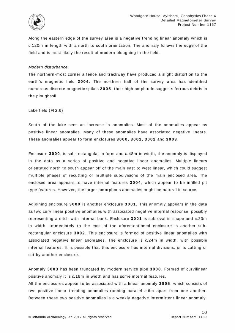
Lake field (FIG.6)
South of the lake sees an increase in anomalies. Most of the anomalies appear as
positive linear anomalies. Many of these anomalies have associated negative linears.
These anomalies appear to form enclosures 3000, 3001, 3002 and 3003.
Enclosure 3000, is sub-rectangular in form and c.48m in width, the anomaly is displayed
in the data as a series of positive and negative linear anomalies. Multiple linears
orientated north to south appear off of the main east to west linear, which could suggest
multiple phases of recutting or multiple subdivisions of the main enclosed area. The
enclosed area appears to have internal features 3004, which appear to be infilled pit
type features. However, the larger amorphous anomalies might be natural in source.
Adjoining enclosure 3000 is another enclosure 3001. This anomaly appears in the data
as two curvilinear positive anomalies with associated negative internal response, possibly
representing a ditch with internal bank. Enclosure 3001 is sub-oval in shape and c.20m
in width. Immediately to the east of the aforementioned enclosure is another sub-
rectangular enclosure 3002. This enclosure is formed of positive linear anomalies with
associated negative linear anomalies. The enclosure is c.24m in width, with possible
internal features. It is possible that this enclosure has internal divisions, or is cutting or
cut by another enclosure.
Anomaly 3003 has been truncated by modern service pipe 3008. Formed of curvilinear
positive anomaly it is c.18m in width and has some internal features.
All the enclosures appear to be associated with a linear anomaly 3005, which consists of
two positive linear trending anomalies running parallel c.6m apart from one another.
Between these two positive anomalies is a weakly negative intermittent linear anomaly.

Woodgate House, Aylsham, Geophysics Phase 4 Detailed Magnetometer Survey
Project Number 1167
11 ©Britannia Archaeology Ltd 2017 all rights reserved Report Number: 1139
The negative response given by anomaly 3005 may represent a metalled surface.
Therefore 3005 could be a form of trackway that enclosures 3000 – 3002 are aligned
off of. Running north-east to south-west is another anomaly 3006 which is similar in
appearance to anomaly 3005. This may be the remnants of another trackway.
To the north of the lake another survey area has discovered more positive and negative
linear anomalies 3007, these anomalies have a similar form and orientation to the
anomalies south of the lake. These anomalies have been truncated by the construction of
the lake.
Modern disturbance
A strong magnetic liner anomaly 3008 has been identified running north-west to south-
east in the southern survey area. This anomaly is a buried fence. This anomaly has
masked part of enclosure 3003.
An area of increased magnetic noise has been identified in the southern survey area.
This area has been interpreted as an area of disturbed ground 3009, possibly relating to
the construction of the lake. Several areas of magnetic disturbance can be seen on the
edges of the southern survey area, these have been caused by a metal fence which has
produces a distortion in the local magnetic field.
The most numerous anomaly in the southern most survey area were discrete magnetic
spikes. These consist of a high amplitude magnetic spike in the data which most likely
represent buried ferrous debris within the topsoil.
Conclusion
The geophysical surveys have so far identified numerous anomalies which appear to be
of archaeological origin. The majority of anomalies present within the survey areas have
been positive linear anomalies, which are synonymous with infilled ditch type features. A
large quantity of these anomalies have associated negative linears, which may indicate
the presence of remnant bank material, possibly indicating bank and ditch type features.
The varying signal strengths of some of these anomalies, particularly in the two northern
fields, is suggestive of the features being intermittently truncated or disturbed at the
source.
The survey area south of the lake has revealed numerous anomalies which appear to
form enclosures. These enclosures appear as positive responses with associated low
Woodgate House, Aylsham, Geophysics Phase 4 Detailed Magnetometer Survey
Project Number 1167
12 ©Britannia Archaeology Ltd 2017 all rights reserved Report Number: 1139
amplitude negative responses, which is indicative of ditches and banks. These enclosures
appear to be related to a linear anomaly formed of a low amplitude negative response
between two low amplitude positive linear anomalies suggesting that this anomaly could
be a trackway with a metalled surface.
The magnetic contrasts seen in the data indicates the underlying geology was suited to
magnetic geophysical survey. However, the magnetic contrast is clearer in the
southernmost survey areas where the land has not been subjected to modern ploughing.
8.0 PROJECT ARCHIVE AND DEPOSITION
A full archive will be prepared for all work undertaken in accordance with guidance from
the Selection, Retention and Dispersion of Archaeological Collections, Archaeological
Society for Museum Archaeologists, 1993. Arrangements will be made for the archive to
be deposited with the relevant museum/HER Office, in this case will be the Norwich
Castle Museum.
9.0 ACKNOWLEDGEMENTS
Britannia Archaeology Ltd would like to thank Mr Peter Purdy for commissioning the work
and for allowing access to the land. Britannia Archaeology would also like to thank the
volunteers of the Aylsham Roman Project for their help in conducting the surveys.
The survey was undertaken by volunteers of the Alysham Roman Project and Britannia
Archaeology.

Woodgate House, Aylsham, Geophysics Phase 4 Detailed Magnetometer Survey
Project Number 1167
13 ©Britannia Archaeology Ltd 2017 all rights reserved Report Number: 1139
Bibliography Ayala. G. et al. 2004. Geoarchaeology; Using Earth Sciences to Understand the Archaeological Record. English Heritage. Chartered Institute for Archaeologists. 2014. Standard and Guidance for Geophysical Survey Clark. A. J. 1996. Seeing Beneath the Soil, Prospecting Methods in Archaeology. BT Batsford Ltd, London. David. A. 1995. Geophysical Survey in Archaeological Field Evaluation: Research and Professional Services Guidelines. No.1. English Heritage. David. A. et al. 2008. Geophysical Survey In Archaeological Field Evaluation, Second Edition. English Heritage. Department for Communities and Local Government, 2012.National Planning Policy Framework (NPPF) English Heritage, 2008. Geophysical Survey in Archaeological Field Evaluation. Research and Professional Service Guideline No 1, 2nd edition. Gaffney. C, Gater. J. and Ovenden. S. 2002. The Use of Geophysical Techniques in Archaeological Evaluations. IFA Technical Paper No. 6. Gaffney. C. and Gater. J. 2003. Revealing the Buried Past, Geophysics for Archaeologists. Tempus Publishing Ltd. Gurney, D. 2003. Standards for Archaeology in the East of England, East Anglian Archaeology Occasional Paper 14. Institute for Archaeologists. 2011. Standard and Guidance for Archaeological Geophysical Survey. Linford. N. 2006. Notes from an English Heritage Seminar. Schmidt. A. 2001. Geophysical Data in Archaeology: A Guide to Good Practice. Archaeology Data Service. Oxbow Books. Whitten. D.G.A. 1978. The Penguin Dictionary of Geology. Penguin Books Ltd. London. Witten. A.J. 2006. Handbook of Geophysics and Archaeology. Equinox Publishing Ltd. London.

Woodgate House, Aylsham, Geophysics Phase 4 Detailed Magnetometer Survey
Project Number 1167
14 ©Britannia Archaeology Ltd 2017 all rights reserved Report Number: 1139
Websites The British Geological Survey, 2016, (Natural Environment Research Council) – Geology of Britain Viewer - www.bgs.ac.uk/opengeoscience/home.html?Accordion2=1#maps

33.3m
Nursery
The
Lodge
C
a
w
s
t
o
n
R
o
a
d
Dra
in
Woodgate Cottages
30.6m
Path (um)
Woodgate
House
B
1
1
4
5
ST
ON
EG
AT
E
Water
The Round
Pond
Pond
33.3m
Pond
Path
(um
)
30.1m
T
r
a
c
k
M
a
rrio
tt's
W
a
y
Nursery
The
Lodge
FB
2
1
T
r
a
c
k
T
ra
c
k
ESS
PEABODY ROAD
W
O
O
D
G
A
T
E
W
A
Y
8
10
15
2
12 17
1
11
2
11
12
Ppg Sta
14
20
H
O
BA
R
T LA
N
E
4
2
8
16
40
50
PUMPHREY WAY
17
19
5
9
Nelson
Close
1
4
7
6
1
8
5
6
11
9
25
7
23
ST
ON
EG
AT
E
ST
ON
EG
AT
E
UNIT 2
THE OLD WOOL WAREHOUSE
ST ANDREWS STREET SOUTH
BURY ST EDMUNDS
SUFFOLK
IP33 3PH
1
MJB
N
FIGURE:
326000
Norfolk
Suffolk
Essex
Cromer
Kings
Lynn
Thetford
SITE
NORWICH
Reproduced on plans supplied by the client
from the Ordnance Survey map with the
permission of the controller of Her Majesty’s
Stationery Office. Licence number:
100052663.
© CROWN COPYRIGHT 2017.
SITE
BRITANNIA ARCHAEOLOGY LTD
T: 01449 763034
W: www.britannia-archaeology.com
AUTHOR:
APPROVED:
DATE: PLOT: VERSION:
FEB 2017
DPM
DESCRIPTION:
GENERAL LOCATION AND GRID PLAN
PROJECT:
CLIENT:
© Copyright Britannia Archaeology Ltd 2017
WOODGATE HOUSE, AYLSHAM,
GEOPHYSICS PHASE 4
AYLESHAM ROMAN PROJECT
618200 326000
NGR: REF:
P1167
A3 1
618200
Site Boundary
0 100m
1:2500
1:2500

33.3m
Nursery
The
Lodge
C
a
w
s
t
o
n
R
o
a
d
Drain
Woodgate Cottages
30.6m
Woodgate
House
B
1
1
4
5
ST
ON
EG
AT
E
Water
Pond
Pond
33.3m
Pond
30.1m
T
r
a
c
k
Nursery
The
Lodge
FB
2
1
T
ra
c
k
ESS
PEABODY ROAD
W
O
O
D
G
A
T
E
W
A
Y
8
10
15
2
12 17
1
11
2
11
12
Ppg Sta
14
20
H
O
BA
R
T LA
N
E
4
2
8
Close
9
23
The Round
UNIT 2
THE OLD WOOL WAREHOUSE
ST ANDREWS STREET SOUTH
BURY ST EDMUNDS
SUFFOLK
IP33 3PH
2
MJB
N
FIGURE:
Reproduced on plans supplied by the client
from the Ordnance Survey map with the
permission of the controller of Her Majesty’s
Stationery Office. Licence number:
100052663.
© CROWN COPYRIGHT 2016.
BRITANNIA ARCHAEOLOGY LTD
T: 01449 763034
W: www.britannia-archaeology.com
AUTHOR:
APPROVED:
DATE: PLOT: VERSION:
NOV 2016
DPM
DESCRIPTION:
NON-PROCESSED DATA PLAN
PROJECT:
CLIENT:
© Copyright Britannia Archaeology Ltd 2016
WOODGATE HOUSE, AYLSHAM,
GEOPHYSICS PHASE 4
AYLSHAM ROMAN PROJECT
618200 326000
NGR: REF:
P1167
0 100m
1:2000
A3 1
Site Boundary
1:2000
+100nT
-100nT

33.3m
Nursery
The
Lodge
C
a
w
s
t
o
n
R
o
a
d
Drain
Woodgate Cottages
36.5m
30.6m
Woodgate
House
B
1
1
4
5
ST
ON
EG
AT
E
Water
Pond
Pond
33.3m
Pond
30.1m
T
r
a
c
k
Nursery
The
Lodge
2
1
T
ra
c
k
FB
ESS
PEABODY ROAD
W
O
O
D
G
A
T
E
W
A
Y
8
10
15
2
12 17
1
11
2
11
12
Ppg Sta
14
20
H
O
BA
R
T LA
N
E
4
2
8
40
Nelson
Close
1
46
9
23
The Round
UNIT 2
THE OLD WOOL WAREHOUSE
ST ANDREWS STREET SOUTH
BURY ST EDMUNDS
SUFFOLK
IP33 3PH
3
MJB
N
FIGURE:
+ nT
- nT
Reproduced on plans supplied by the client
from the Ordnance Survey map with the
permission of the controller of Her Majesty’s
Stationery Office. Licence number:
100052663.
© CROWN COPYRIGHT 2017.
BRITANNIA ARCHAEOLOGY LTD
T: 01449 763034
W: www.britannia-archaeology.com
AUTHOR:
APPROVED:
DATE: PLOT: VERSION:
FEB 2017
DPM
DESCRIPTION:
PROCESSED DATA PLAN
PROJECT:
CLIENT:
© Copyright Britannia Archaeology Ltd 2017
WOODGATE HOUSE, AYLSHAM,
GEOPHYSICS PHASE 4
AYLSHAM ROMAN PROJECT
618200 326000
NGR: REF:
P1167
0 100m
1:2000
A3 1
Site Boundary
1:2000

33.3m
Nursery
The
Lodge
C
a
w
s
t
o
n
R
o
a
d
Drain
Woodgate Cottages
36.5m
30.6m
Woodgate
House
B
1
1
4
5
ST
ON
EG
AT
E
Water
The Round
Pond
Pond
33.3m
Pond
30.1m
T
r
a
c
k
Nursery
The
Lodge
2
1
T
ra
c
k
FB
ESS
PEABODY ROAD
W
O
O
D
G
A
T
E
W
A
Y
8
10
15
2
12 17
1
11
2
11
12
Ppg Sta
14
20
H
O
BA
R
T LA
N
E
4
2
8
Close
9
23
UNIT 2
THE OLD WOOL WAREHOUSE
ST ANDREWS STREET SOUTH
BURY ST EDMUNDS
SUFFOLK
IP33 3PH
4
MJB
N
FIGURE:
Reproduced on plans supplied by the client
from the Ordnance Survey map with the
permission of the controller of Her Majesty’s
Stationery Office. Licence number:
100052663.
© CROWN COPYRIGHT 2017.
BRITANNIA ARCHAEOLOGY LTD
T: 01449 763034
W: www.britannia-archaeology.com
AUTHOR:
APPROVED:
DATE: PLOT: VERSION:
FEB 2017
DPM
DESCRIPTION:
INTERPRETATION PLOT
PROJECT:
CLIENT:
© Copyright Britannia Archaeology Ltd 2017
WOODGATE HOUSE, AYLSHAM,
GEOPHYSICS, PHASE 4
AYLSHAM ROMAN PROJECT
618200 326000
NGR: REF:
P1167
0 100m
1:2000
A3 1
Site Boundary
1:2000
Kiln
Negative Anomaly
Positive Anomaly
Service pipe
Magnetic disturbance
Strong magnetic noise
Discrete magnetic spike

Nursery
C
a
w
s
t
o
n
R
o
a
d
ST
ON
EG
AT
E
The Round
Nursery
UNIT 2
THE OLD WOOL WAREHOUSE
ST ANDREWS STREET SOUTH
BURY ST EDMUNDS
SUFFOLK
IP33 3PH
5
MJB
N
FIGURE:
Reproduced on plans supplied by the client
from the Ordnance Survey map with the
permission of the controller of Her Majesty’s
Stationery Office. Licence number:
100052663.
© CROWN COPYRIGHT 2016.
BRITANNIA ARCHAEOLOGY LTD
T: 01449 763034
W: www.britannia-archaeology.com
AUTHOR:
APPROVED:
DATE: PLOT: VERSION:
FEB 2017
DPM
DESCRIPTION:
INTERPRETATION PLOT
PROJECT:
CLIENT:
© Copyright Britannia Archaeology Ltd 2016
WOODGATE HOUSE, AYLSHAM,
GEOPHYSICS, PHASE 4
AYLSHAM ROMAN PROJECT
618200 326000
NGR: REF:
P1167
A3 1
Site Boundary
1000
1001
1002
1003
1005
1004
1006
1006
1006
1007
1007
1007
2000
2001
2002
2003
2004
2005
2005
2005
2005
2005
0 50m
1:1000
1:1000
Kiln
Negative Anomaly
Positive Anomaly
Magnetic disturbance
Strong magnetic noise
Discrete magnetic spike

30.6m
Pond
UNIT 2
THE OLD WOOL WAREHOUSE
ST ANDREWS STREET SOUTH
BURY ST EDMUNDS
SUFFOLK
IP33 3PH
6
MJB
N
FIGURE:
Reproduced on plans supplied by the client
from the Ordnance Survey map with the
permission of the controller of Her Majesty’s
Stationery Office. Licence number:
100052663.
© CROWN COPYRIGHT 2017.
BRITANNIA ARCHAEOLOGY LTD
T: 01449 763034
W: www.britannia-archaeology.com
AUTHOR:
APPROVED:
DATE: PLOT: VERSION:
FEB 2017
DPM
DESCRIPTION:
INTERPRETATION PLOT
PROJECT:
CLIENT:
© Copyright Britannia Archaeology Ltd 2017
WOODGATE HOUSE, AYLSHAM,
GEOPHYSICS, PHASE 4
AYLSHAM ROMAN PROJECT
618200 326000
NGR: REF:
P1167
A3 1
Site Boundary
3000
3002
3003
3001
3004
3005
3005
3006
3008
3007
0 50m
1:1000
1:1000
Negative Anomaly
Positive Anomaly
Service pipe
Magnetic disturbance
Strong magnetic noise
Discrete magnetic spike