Virginia Department of Transportation · Virginia Department of Transportation . ... to the noise...
82
Virginia Department of Transportation Route 17 Bridge over I-95 to Hospital Boulevard in Spotsylvania County State Project Number: 0017-088-R72, B616, P101 UPC 107140 From: Intersection with US Route 1 (Jefferson Davis Highway) To: 0.90 Miles South of Intersection with US Route 1 Spotsylvania County, Virginia Fredericksburg District PRELIMINARY NOISE ANALYSIS Virginia Department of Transportation Environmental Division 1401 East Broad Street Richmond, Virginia 23219 June 2017
Transcript of Virginia Department of Transportation · Virginia Department of Transportation . ... to the noise...

Virginia Department of Transportation
Route 17 Bridge over I-95 to Hospital Boulevard in Spotsylvania County
State Project Number: 0017-088-R72, B616, P101
UPC 107140 From: Intersection with US Route 1 (Jefferson Davis Highway)
To: 0.90 Miles South of Intersection with US Route 1 Spotsylvania County, Virginia
Fredericksburg District
PRELIMINARY NOISE ANALYSIS
Virginia Department of Transportation
Environmental Division 1401 East Broad Street Richmond, Virginia 23219
June 2017

i
TABLE OF CONTENTS
I. Executive Summary ....................................................................................................................... i
II. Introduction and Background ................................................................................................... 1
III. Noise Analysis Methodology, Terminology and Criteria ...................................................... 1
IV. Noise Monitoring Methodology ................................................................................................ 2
V. Undeveloped Lands ..................................................................................................................... 3
VI. Validation and Existing Conditions ......................................................................................... 3
VII. Evaluation of Design Year Noise Levels and Noise Impact Assessment ............................ 5 CNE 1.......................................................................................................................................... 6
CNE 2.......................................................................................................................................... 6
CNE 3.......................................................................................................................................... 6
CNE 4.......................................................................................................................................... 6
CNE 5.......................................................................................................................................... 7
VIII. Noise Abatement Evaluation ................................................................................................. 7
IX. Construction Noise Considerations ........................................................................................ 11
X. Conclusion .................................................................................................................................. 14

ii
TABLES
Table 1 – FHWA Noise Abatement Criteria Table 2 – Field Measurement Data Table 3 – TNM Validation Table 4 – Noise Impact Summary by CNE Table 5 – CNE Specific Noise Contours
FIGURES
Figure 1 – Regional Area Map Figure 2 – Project Area Map Figure 3 – Project Improvements Figure 4 – Detailed Study Area Figure 5 – Modeled Locations Figure 6 – 66 dB(A) Contour
APPENDICES
Appendix A – Short-Term Measurements Field Data Sheets Appendix B – Noise Meters Calibration Certificates Appendix C – Spotsylvania County Planning Department Correspondence Appendix D – Traffic Data Appendix E – Warranted, reasonable and feasible worksheets Appendix F – References Appendix G – List of Preparers and Reviewers

i
I. Executive Summary This report addresses the noise evaluation performed for widening Route 17 from two lanes to four lanes and replacement of the structurally deficient bridge over Interstate 95 in Spotsylvania County, Virginia. The new bridge and associated approaches would accommodate four lanes on Route 17 with a shared use path on the north side of the bridge and a sidewalk on the south side. The design year for the project is 2040. The project location and the study area are depicted in Figure 1 and Figure 2.
Noise abatement was evaluated for the noise sensitive receptors based on the Virginia Department of Transportation (VDOT) and Federal Highway Administration (FHWA) criteria for Type I noise abatement. All noise modeling was performed using Version 2.5 of the FHWA Traffic Noise Model (FHWA TNM) and are in accordance with the VDOT Highway Traffic Noise Impact Analysis Guidance Manual, dated July 14, 2015 (Version 7).
For analysis purposes, the project study area was divided into five (5) Common Noise Environments (CNEs). CNEs include representative noise sensitive receptors within 500 feet of the project area. The analysis includes evaluating noise sensitive receptors in all five CNEs for the Existing Year (2014), the Design Year (2040) Build and the Design Year (2040) No Build scenarios. A field visit was conducted at the project site to perform noise measurements at 14 locations and document field parameters to include in the Traffic Noise Model (TNM). An additional 11 sites were included in the model to further represent the noise sensitive sites within the five (5) CNEs. Noise modeling was completed for Existing Year (2014) and Design Year (2040) Build and No Build conditions. Design Year (2040) Build noise levels were predicted at each modeled receptor site under the proposed widening scenario. For purposes of validating the FHWA TNM, noise measurements and concurrent traffic counts were conducted in all CNEs and are reported in Table 2. Normal traffic growth can be expected to generally increase noise levels by from one to three dB(A) in the project area. Noise levels were predicted at all modeled and measured receivers representing 87 single family residences and two large multi-family developments for all modeling scenarios (Activity Category B and C – Table 1). Under Design Year (2040) Build conditions a total of two receptors representing one residence and one residential complex swimming pool are predicted to experience noise impacts. These two impacts are predominately from I-95 and not attributed to widening of the Route 17 project. Based on the evaluation of existing and future noise levels and the noise abatement criteria (NAC) described in Table 1, project-related noise impacts were considered negligible in all CNEs with the exception of one receptor in each of CNEs 1 and 3. Noise barriers were evaluated and determined not to be feasible or reasonable. A detailed discussion of the noise abatement evaluation follows in Section VIII of this report. No considerable, long-term construction related noise impacts are anticipated. Any noise impacts that do occur as a result of roadway construction measures are anticipated to be temporary in nature and would cease upon completion of the project construction phase.

Route 17 Bridge over I-95 at Hospital Blvd 1 Preliminary Noise Analysis Spotsylvania County
II. Introduction and Background Noise impacts are often a concern for roadway improvement projects when noise sensitive environments are located adjacent to the project area. Noise analysis methodology and noise level criteria established by Federal Highway administration (FHWA) and Virginia Department of Transportation (VDOT) are utilized to assess the potential noise impacts of the transportation improvement projects.
This report addresses the noise evaluation performed for widening Route 17 from two lanes to four lanes and to replace the structurally deficient bridge over Interstate 95 in Spotsylvania County, Virginia. The new bridge and approaches would accommodate four lanes on Route 17 with a shared use path on the north side of the bridge and a sidewalk on the south side. The project location and the study area are depicted in Figure 1 and Figure 2. The land use along the corridor is mainly residential. The planned project area improvements are depicted in Figure 3.
Noise monitoring, noise modeling and impact evaluation were performed for noise sensitive receptors based on the Virginia Department of Transportation (VDOT) and Federal Highway Administration (FHWA) criteria for Type I noise abatement; generally within 500 feet of the construction limits depicted in Figure 4.
III. Noise Analysis Methodology, Terminology and Criteria The methodologies applied to the noise analysis for the widening of Route 17 is in accordance with
VDOT’s “State Noise Abatement Policy” effective July 13, 2011 and the “Highway Traffic Noise Impact Analysis Guidance Manual”, updated July 14, 2015. VDOT guidelines are based on Title 23 of the Code of Federal Regulations, Part 772 and the Procedures for Abatement of Highway Traffic Noise and Construction Noise, (23 CFR 772). To determine the degree of highway noise impact, Noise Abatement Criteria (NAC) have been established for a number of different land use categories that are considered to be sensitive to highway traffic noise. Table 1, located at the end of this report, documents the NAC for the associated activity land use category shown in the adjacent column. The project is considered developed with dense areas of residential development. For the purposes of this analysis, the majority of the land uses are considered Category B (residential), with one Category C (an apartment pool) land use within the project study area. The NAC are given in terms of an hourly, A-weighted, equivalent noise level. The A-weighted noise level frequency is used for human use areas because it is comprised of the noise level frequencies that are most easily distinguished by the human ear within the noise level spectrum. Highway traffic noise is categorized as a linear noise source, where varying noise levels occur at a fixed point during a single vehicle pass by due to the Doppler effect and is affected by physical barriers between the noise source and the receptor location as well as weather conditions. It is acceptable to characterize these fluctuating noise levels with a single number known as the equivalent noise level (Leq). The Leq is the value of a steady noise level that would represent the same acoustic energy as the actual time-varying sound evaluated over the same time period. For highway noise assessments, Leq is typically evaluated over a one-hour period.

Route 17 Bridge over I-95 at Hospital Blvd 2 Preliminary Noise Analysis Spotsylvania County
Noise abatement determination is based on VDOT’s three-phased approach. The first phase (Phase 1) distinguishes if a sensitive receptor within a project corridor warrants highway traffic noise abatement. The following describes the Phase 1 warranted criterion, as discussed in VDOT policy. Receptors that satisfy either condition warrants consideration of highway traffic noise abatement.
• Predicted highway traffic noise levels (for the design year) approach or exceed the highway traffic noise abatement criteria in Table 1. “Approach” has been defined by VDOT as 1 dB(A) below the noise abatement criteria.
~or~ • A substantial noise increase has been defined by VDOT as a 10 dB(A) increase above existing noise levels for all noise sensitive exterior activity categories. A 10 dB(A) increase in noise reflects the generally accepted range of a perceived doubling of the loudness.
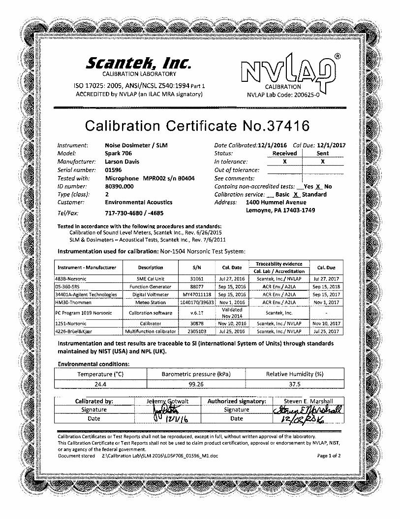
If a traffic noise impact is identified within the project corridor, then consideration of noise abatement measures is necessary. The final decision on whether or not to provide noise abatement along a project corridor will take into account the feasibility of the design and overall cost weighted against the benefit. Phase 2 and Phase 3 of the three-phased approach are discussed in the noise abatement evaluation section of this report. IV. Noise Monitoring Methodology The identification of noise sensitive land uses with aerial imagery and local government parcel data guided the selection of noise monitoring locations along the project corridor. In order to validate the noise models, noise monitoring was conducted at 14 representative noise sensitive receptor sites. Figure 3 shows an overview of the build alternative and Figure 4 shows the locations of the 14 noise monitoring sites. Short-term noise monitoring is not a process to determine design year noise impacts or barrier locations. Short-term noise monitoring provides a level of consistency between what is present in real-world situations and how that is represented in the computer noise model. Common Noise Environments (CNEs) are groupings of receptor sites that, by location, form distinct communities within the project area and are exposed to similar noise sources and levels; traffic volumes, traffic mix, and speed; and topographic features. These areas are used to evaluate traffic noise impacts and potential noise mitigation options to residential developments or communities as a whole, as well as for consideration of feasibility and reasonableness of possible noise abatement measures for specific communities. Monitoring was performed at 14 noise sensitive receptors using Type I Rion NA-28 sound level meters on the A-weighted scale and reported in decibels (dB(A)). The sound level meters (SLM) were calibrated with a Rion NC-74 calibrator. The SLMs meet the American National Standard Specifications for Sound Level Meters, ANSI S1.4-1983 (R1991) Type 1 requirements as well as those defined by FHWA. The SLMs were used to measure typical ambient background levels at each site in accordance with the methodologies contained in FHWA-PD-96-046, Measurement of Highway-Related Noise (FHWA, May 1996). See Appendix A for the field data sheets. Calibration certificates related to noise meters and calibrators are contained in Appendix B.

Route 17 Bridge over I-95 at Hospital Blvd 3 Preliminary Noise Analysis Spotsylvania County
Ambient noise measurements were conducted throughout the project study area. Short-term noise monitoring was performed on March 23rd of 2017 during hours of free flow conditions. Within each of the CNEs, short-term (20-minute duration) noise readings were taken along with concurrent traffic counts at 14 locations. Readings were taken on the A-weighted scale and reported in decibels (dB(A)). It should be noted that short-term measurements were taken at various times during the day on March 23rd, 2017 and did not necessarily represent the noisiest condition at any particular measurement site (receptor). However all roads had free flow traffic conditions during measurement periods. In addition, measurement sites (receptors) were positioned in order to enable validation of the noise prediction model and to assist in defining existing noise levels for second-row residences and for receivers located within approximately 500 feet of Route 17 or the connection of Glenwood Drive and Germanna Point Drive. Data collected included, Leq, Lmin, Lmax, and SEL as well as site geometry, unusual noise events, ambient weather conditions (including temperature, humidity and wind speeds) and latitude and longitude. Traffic was counted on local roads, as well as Route 17 and I-95 during each measurement period and grouped by autos, medium trucks, heavy trucks, buses, and motorcycles. Measured existing Leq noise levels at short-term measurement sites (receptors) ranged from 43 to 69 dB(A). This data was use in FHWA’s Traffic Noise Model (TNM 2.5) to validate the project site model. V. Undeveloped Lands Highway traffic noise analyses are performed for developed lands as well as undeveloped lands if they are considered “permitted”. Undeveloped lands are deemed to be permitted when there is a definite commitment to develop land with an approved specific design of land use activities as evidenced by the issuance of at least one building permit. In accordance with the VDOT State Noise Policy, an undeveloped lot is considered to be planned, designed, and programmed if a building permit has been issued by the local authorities prior to the Date of Public Knowledge for the relevant project. The Spotsylvania County Planning Department has no current record of planned or pending development upon the undeveloped land included in the Project Area (Tax Map# 36-14-1 or TM 36-14-2) as of April 2017. There are no prior approved or active re-zoning, special use permits, site plans, plats, building permits in the Spotsylvania system. Correspondence from Spotsylvania County Planning Department is included in Appendix C. VDOT considers the Date of Public Knowledge as the date that the final National Environmental Policy Act (NEPA) approval is made. VDOT has no obligation to provide noise mitigation for any undeveloped land that is permitted or constructed after the date of Public Knowledge. As a result of the above coordination with Spotsylvania County, no ongoing permitted land uses appear to be present within the project corridor. VI. Validation and Existing Conditions The FHWA Traffic Noise Model (TNM 2.5) is the approved highway noise prediction model for predicting the Existing (2014) and Design Year (2040) noise levels associated with traffic-induced noise. The modeling process begins with model validation, as per VDOT requirements. The short-term noise measurements concurrently with the traffic data, site specific topography and existing

Route 17 Bridge over I-95 at Hospital Blvd 4 Preliminary Noise Analysis Spotsylvania County
characteristics were modeled and compared to measured noise levels. A difference of 3 dB(A) or less between the monitored and modeled level is considered acceptable. This comparison ensures that reported changes in noise levels between Existing (2014) and Design Year (2040) conditions are due to changes in traffic conditions and not to discrepancies between monitoring and modeling techniques. Existing conditions include terrain lines based on site topography, barriers from buildings, local roads, and existing traffic. Existing short-term measured noise levels and hourly traffic data based on concurrent traffic counts are summarized in Table 4, with field measurement data sheets contained in Appendix A. Validation results are shown in Table 5. The measured versus modeled noise levels were within the acceptable 3 dB(A) range for all sites evaluated, therefore the FHWA TNM is considered to be validated for this project. The results of the validation process were used to help model the FHWA TNM used for purposes of modeling existing and future year noise levels, determining future year impacts, and evaluating potential noise abatement options. There are many factors that influence the measured noise levels that may cause differences with computed noise levels of several decibels. Such factors included atmospheric conditions (upwind, neutral or downwind), shielding by structures, and the representation of louder vehicles passing during the measurement period. The validated noise model was the base noise model for the remainder of the noise analysis. Modeling sites were added to the validated model to thoroughly predict Existing (2014) noise levels throughout the project area. Additional noise modeling was then performed for existing conditions using 2014 traffic data supplied by VDOT (see Appendix D). This modeling step was performed to predict Existing (2014) worst-case noise levels associated with existing worst-case traffic volumes and composition. Table 4 provides a summary of the modeled Existing (2014) predicted worst-case noise levels in the project area. Analysis locations were grouped into five CNEs which are groupings of receptor sites that, by location, form distinct communities within the project area and have a common noise environment. These areas were used to evaluate traffic noise impacts and potential noise abatement options and to assess the feasibility and reasonableness of potential noise abatement measures for specific communities. Where residential communities or groupings of noise sensitive land use areas exist, both noise monitoring and noise modeling-only sites were grouped into a CNE. A description of each CNE is provided below. For noise analysis purposes, the project study area was divided into the following CNEs as shown in Figure 2:
CNE 1 Activity Category B land uses located adjacent to the eastbound travel lanes (south side) of Route 17, including multi-family (Overlook Terrace apartments) residential dwellings on Lookout Lane (Figure 3). The modeled existing (2014) worst-case noise level within CNE 1 is predicted to range from 54-68 dB(A). Modeled existing (2014) noise levels exceed the NAC in this CNE with noise impacts at one receptor representing the pool at Overview Terrace Apartments, as shown in Figures 2 and 3 and Table 5.

Route 17 Bridge over I-95 at Hospital Blvd 5 Preliminary Noise Analysis Spotsylvania County
CNE 2 Activity Category B land uses located adjacent to the westbound travel lanes (north side) of Route 17 and to the east of Glenwood Drive, including Glenwood Manufactured Home Community (Figure 3). The modeled existing (2014) worst-case noise level within CNE 2 is predicted to range from 52-62 dB(A), with no noise impacts modeled, as shown in Figures 2 and 3 and Table 5. Modeled existing (2014) noise levels do not approach or exceed the NAC in this CNE.
CNE 3 Activity Category B land uses located to the west of Glenwood Drive (Figure 4). The modeled existing (2014) worst-case noise level within CNE 3 is predicted to range from 64-66 dB(A). Modeled existing (2014) noise levels exceed the NAC in this CNE with noise impacts at receptor 3-1 on Gleewood Drive, as shown in Figure 2 and 3 and Table 5.
CNE 4 Activity Category B land uses located adjacent to the northbound travel lanes (west side) Germanna Point Drive, including multi-family (Matti Hill Ct) residential dwellings (See Figure 3). The modeled existing (2014) worst-case noise level within CNE 4 is predicted to range from 50-52 dB(A), with no noise impacts modeled, as shown in Figures 2 and 3 and Table 5. Modeled existing (2014) noise levels do not approach or exceed the NAC in this CNE.
CNE 5 Activity Category B land uses located on Lee Hill School Drive near the corner of Route 17 and Germanna Point Drive (Figure 3). The modeled existing (2014) worst-case noise level within CNE 4 is predicted to range from 57-60 dB(A), with no noise impacts modeled, as shown in Figures 2 and 3 and Table 5. Modeled existing (2014) noise levels do not approach or exceed the NAC in this CNE.
VII. Evaluation of Design Year Noise Levels and Noise Impact Assessment The model used to predict worst case existing and future noise levels and to evaluate noise abatement options was the FHWA’s TNM, Version 2.5. The FHWA TNM predicts noise levels at selected locations based on traffic data, roadway design, topographic features, and the relationship of the analysis site (receiver) to nearby roadways. ENTRADA is not currently available for this project, VDOT has provided preliminary traffic number that they indicated will for the preliminary study. However, ENTRADA will be developed for the Final Design Noise Analysis which will include hourly volumes, compositions, and operational speeds. Existing and future traffic data used were based on design hourly volume, D and T factors provided by VDOT. The traffic data used for modeling was approved by VDOT noise specialist. Traffic data used for prediction of existing (year 2014) and future (year 2040) noise levels for both no-barrier and barrier conditions is contained in Appendix D. The percentages of automobiles, medium trucks, and heavy trucks used in the FHWA TNM modeling process were developed from review of traffic classification data obtained from VDOT. The modeled speed of 35 mph on Route 17 was based on the information provided by VDOT (see Appendix D).
The modeled sites included in the existing model were used to predict the Design Year (2040) noise levels throughout the project area. Additional noise modeling was then performed for existing conditions using 2040 traffic data supplied by VDOT (see Appendix D). This modeling

Route 17 Bridge over I-95 at Hospital Blvd 6 Preliminary Noise Analysis Spotsylvania County
step was performed to predict Design Year (2040) worst-case noise levels associated with existing worst-case traffic volumes and composition. This modeled analysis was performed with the planned project improvements (Design Year Build Alternative). Table 4 provides a summary of the modeled Design Year (2040) predicted worst-case noise levels in the project area for the Build Alternative. The following describes the locations and predicted sound levels of each CNE in the Route 17 Bridge Improvement Projects study area. CNE 1 is located in the southern project area while the remaining CNEs (2 through 5) are located in the northern project area. The CNEs are shown in Figures 2 and 3. All CNEs are located east of the Route 17 Bridge and are all residential. CNE 1 The dominant noise source within CNE 1 is I- 95. The Design Year (2040) Build sound levels are predicted to range from 59-69 dB(A), with noise impacts at one receptor representing the Overview Terrace Apartment pool attributed to noise levels from I-95 and are not related to the widening of Route 17. CNE 1 is comprised of four (4) measurement sites and five (5) modeled sites representing approximately 10 single family residences and two (2) multifamily residences. Due to Design Year (2040) Build sound levels exceeding the NAC, noise abatement is considered warranted and will be discussed in Section VIII. CNE 2 The dominant noise source within CNE 2 is I- 95. The Design Year (2040) Build sound levels are predicted to range from 53-62 dB(A), with no noise impacts modeled. As such, consideration of noise abatement within this CNE was not warranted. CNE 2 is comprised of five (5) measurement sites and three (3) modeled sites representing approximately 70 single family residences. CNE 3 The dominant noise sources within CNE 3 are I-95 and Route 17. The Design Year (2040) Build sound levels are predicted to range from 65-67 dB(A), with noise impacts modeled at receptor 3-1 on Glenwood Drive attributed to noise levels from I-95 and are not related to the widening of Route 17. CNE 3 is comprised of one (1) measurement site and one (1) modeled site representing two residences. Due to Design Year (2040) Build sound levels exceeding the NAC, noise abatement is considered warranted and will be discussed in Section VIII. CNE 4 The dominant noise source within CNE 4 is Route 17 and local roads. The Design Year (2040) Build sound levels are predicted to range from 50-54 dB(A), with no noise impacts modeled. Traffic data was not available for the new road addition connecting Glenwood Drive to Germanna Point Drive although the volume is expected to be low. As such, consideration of noise abatement within this CNE was not warranted. CNE 4 is comprised of three (3) measurement sites and one (1) modeled site representing 6 multifamily residences.

Route 17 Bridge over I-95 at Hospital Blvd 7 Preliminary Noise Analysis Spotsylvania County
CNE 5 The dominant noise source within CNE 5 is Route 17. The Design Year (2040) Build sound levels are predicted to range from 59-62 dB(A), with no noise impacts modeled. As such, consideration of noise abatement within this CNE was not warranted. CNE 5 is comprised of one (1) measurement site and one (1) modeled site representing two residences. VIII. Noise Abatement Evaluation The appropriate level of highway traffic noise analysis must be completed to adequately address whether noise abatement measures are warranted, feasible, and reasonable. Consideration of noise abatement is required if noise levels approach or exceed the NAC (example: 66 dB(A) or higher for Activity Category B and C land uses) or create a substantial noise increase 10 dB(A) over existing levels. Under 23 CFR 772, if the predicted noise level approaches or exceeds the Noise Abatement Criteria, there is a traffic noise impact regardless of whether or not the proposed project is the cause and noise abatement must be considered. The noise levels for the future year were compared to the NAC levels and to the increases over existing year noise levels to determine if there would be any noise impacts. The Design year (2040) Build noise levels are also predicted to exceed NAC at receivers R1-1 and R3-1. These receivers can be seen in Figure 4 and Figure 5. Phase 2 and Phase 3 of VDOT’s three-phased approach to considering noise abatement and determining the feasibility and reasonableness of noise barriers is discussed below in detail. Phase 2: Feasibility Criteria for Noise Barriers All receptors that meet the warranted criterion must progress to the “feasible” phase. Phase 2 of the noise abatement criteria requires that both of the following acoustical and engineering conditions be considered:
• At least a 5 dB(A) highway traffic noise reduction at impacted receptors. Per 23 CFR 772, FHWA requires the highway agency to determine the number of impacted receptors required to achieve at least 5 dB(A) of reduction. VDOT requires that fifty percent (50%) or more of the impacted receptors experience 5 dB(A) or more of insertion loss to be feasible; and • The determination that it is possible to design and construct the noise abatement measure. The factors related to the design and construction include: safety, barrier height, topography, drainage, utilities, maintenance of the abatement measure, maintenance access to adjacent properties, and general access to adjacent properties (i.e. arterial widening projects). • The noise abatement measure is said to be feasible if it meets both criteria.
FHWA and VDOT guidelines recommend a variety of abatement measures that should be considered in response to transportation-related noise impacts. While noise barriers and/or earth berms are generally the most effective form of noise abatement, additional abatement measures exist that have the potential to provide considerable noise reductions, under certain circumstances. A brief description of VDOT-approved noise abatement measures is provided below:

Route 17 Bridge over I-95 at Hospital Blvd 8 Preliminary Noise Analysis Spotsylvania County
Traffic Control Measures (TCM): Traffic control measures, such as speed limit restrictions, truck traffic restrictions, and other traffic control measures that may be considered for the reduction of noise emission levels are not practical for this project. Reducing speeds will not be an effective noise mitigation measure since a substantial decrease in speed is necessary to provide adequate noise reduction. Typically, a 10 mph reduction in speed will result in only a 2 dB(A) decrease in noise level, which is not considered a sufficient level of attenuation to be considered feasible. Likewise, a 2 dB(A) change in noise is not perceptible to the human ear. Additionally, a reduction in speed is not practical for this project since the posted speed is already 55 miles per hour. Alteration of Horizontal and Vertical Alignments: The alteration of the horizontal and vertical alignment has been considered to reduce or eliminate the impacts created by the proposed project. Because residential development is located adjacent to the project corridor over much of its length, it does not allow for meaningful alterations in the horizontal or vertical alignment without significant impacts. Shifting the horizontal alignment to the east or west of its existing location to reduce noise impacts to receptors will create undesirable impacts such as extensive right-of-way acquisition and potentially relocations. Additionally, shifting the roadway alignment away from one group of receptors to reduce noise impacts will cause noise levels to increase at the receptors the alignment is being moved closer to. By maintaining the existing alignment, the project balances impacts to receptors on both sides of the corridor. Further, altering the vertical alignment is not practical because there is a minimum required clearance for I-95 as it passes under Route 17. Acoustical Insulation of Public-Use and Non-Profit Facilities: This noise abatement measure option applies only to public and institutional use buildings. Since no public use or institutional structures are anticipated to have interior noise levels exceeding FHWA’s interior NAC, this noise abatement option will not be applied. Acquisition of Buffering Land: The purchase of property for noise barrier construction or the creation of a “buffer zone” to reduce noise impacts is only considered for predominantly unimproved properties because the amount of property required for this option to be effective would create significant additional impacts (e.g., in terms of residential displacements), which were determined to outweigh the benefits of land acquisition. Construction of Berms / Noise Barriers: Construction of noise barriers can be an effective way to reduce noise levels at areas of outdoor activity. Noise barriers can be wall structures, earthen berms, or a combination of the two. The effectiveness of a noise barrier depends on the distance and elevation difference between roadway and receptor and the available placement location for a barrier. Gaps between overlapping noise barriers also decrease the effectiveness of the barrier, as opposed to a single continuous barrier. The barrier’s ability to attenuate noise decreases as the gap width increases. Noise walls and earth berms are often implemented into the highway design in response to the identified noise impacts. The effectiveness of a freestanding (post and panel) noise barrier and an earth berm of equivalent height are relatively consistent; however an earth berm is perceived as a more aesthetically pleasing option. In contrast, the use of earth berms is not always an option due

Route 17 Bridge over I-95 at Hospital Blvd 9 Preliminary Noise Analysis Spotsylvania County
to the excessive space they require adjacent to the roadway corridor. In these situations, implementation of earth berms can require significant property acquisitions to accommodate noise mitigation, and the cost associated with the acquisition of property to construct a berm can significantly increase the total costs to implement this form of noise mitigation and make it unreasonable. Availability of fill material to construct the berm also needs to be considered. On proposed projects where proposed grading yields excess waste material, earth berms can often be a cost effective mitigation option. On balance or borrow projects the implementation of earth berms is often an expensive solution due to the need to identify, acquire, and transport the material to the project site. Earth berms may be considered a viable mitigation option throughout the project area, and would be evaluated further where possible in the final design stage. Additionally, the Code of Virginia (§33.1-223.2:21) states: “Whenever the Commonwealth Transportation Board or the Department plan for or undertake any highway construction or improvement project and such project includes or may include the requirement for the mitigation of traffic noise impacts, first consideration should be given to the use of noise reducing design and low noise pavement materials and techniques in lieu of construction of noise walls or noise barriers. Vegetative screening, such as the planting of appropriate conifers, in such a design would be utilized to act as a visual screen if visual screening is required.” Based on the noise analysis, there are two noise impacts at one residence and one swimming pool complex in CNE 1 and CNE 3, respectively. The predicted impacts are due to noise from I-95 and are not related to the widening of Route 17. The receptors are elevated and are significantly exposed to traffic for I-95. It is not likely any barrier, built on I-95 right of way, is feasible and reasonable. Noise mitigation is not recommended for this project. Therefore, there is no need for HB 2577 documentation that inquire about the possibility of noise reducing design, the usage of low noise pavement, and visual screening. In summary, due to right-of-way constraints, noise barriers were considered the only form of abatement having the potential to reduce Design Year (2040) Build noise levels. Phase 3: Reasonableness Criteria for Noise Barriers A determination of noise barrier reasonableness will include the consideration of the parameters listed below. The parameters used during the NEPA process are also used during the final design phase when making a determination of noise barrier reasonableness. All of the reasonableness factors must collectively be achieved in order for a noise abatement measure to be deemed reasonable.
• Viewpoints of the benefited receptors VDOT shall solicit the viewpoints of all benefited receptors through certified mailings and obtain enough responses to document a decision as to whether or not there is a desire for the proposed noise abatement measure. Fifty percent (50%) or more of the respondents shall be required to favor the noise abatement measure in determining reasonableness. Community views in and of themselves are not sufficient for a barrier to be found reasonable if one or both of the other two reasonableness criteria are not satisfied.

Route 17 Bridge over I-95 at Hospital Blvd 10 Preliminary Noise Analysis Spotsylvania County
• Cost-effectiveness
Typically, the limiting factor related to barrier reasonableness is the cost effectiveness value, where the total surface area of the barrier is divided by the number of benefited receptors receiving at least a 5 dB(A) reduction in noise level. VDOT’s approved cost is based on a maximum square footage of abatement per benefited receptor, a value of 1,600 square feet per benefited receptor. Where multi-family housing includes balconies at elevations that exceed a 30-ft high barrier or the topography causes receptors to be above the elevation of a 30-ft barrier, these receptors are not assessed for barrier benefits and are not included in the computation of the barrier’s reasonableness. For non-residential properties such as parks and public use facilities, a special calculation is performed in order to quantify the type and duration of activity and compare to the cost effectiveness criterion. The determination is based on cost, severity of impact (both in terms of noise levels and the size of the impacted area and the activity it contains), and amount of noise reduction.
• Noise Reduction Design Goals
The design goal is a reasonableness factor indicating a specific reduction in noise levels that VDOT uses to identify that a noise abatement measure effectively reduces noise. The design goal establishes a criterion, selected by VDOT, which noise abatement must achieve. VDOT’s noise reduction design goal is defined as a 7 dB(A) insertion loss for at least one impacted receptor, meaning that at least one impacted receptor is predicted to achieve a 7 dB(A) or greater noise reduction with the proposed barrier in place. The design goal is not the same as acoustic feasibility, which defines the minimum level of effectiveness for a noise abatement measure. Acoustic feasibility indicates that the noise abatement measure can, at a minimum, achieve a discernible reduction in noise levels.
Noise reduction is measured by comparing the future design year build condition pre-and post-barrier noise levels. This difference between unabated and abated noise levels is known as “insertion loss” (IL). It is important to optimize the noise barrier design to achieve the most effective noise barrier in terms of both noise reduction (insertion losses) and cost. Although at least a 5 dB(A) reduction is required to meet the feasibility criteria, the following tiered noise barrier abatement goals are used to govern barrier design and optimization.
• Reduction of future highway traffic noise by 7 dB(A) at one (1) or more of the impacted receptor sites (required criterion).
• Reduction of future highway traffic noise levels to the low-60-decibel range when
practical (desirable). • Reduction of future highway traffic noise levels to existing noise levels when practical
(desirable).
The following is a discussion of the potential abatement measures for the impacted CNEs under the worst-case Design Year (2040) Build Alternative. These areas will be identified and described as such. Noise abatement was evaluated where noise impacts are predicted to occur. Where a noise barrier was evaluated, the effectiveness was measured in terms of achievable insertion loss. Noise
Route 17 Bridge over I-95 at Hospital Blvd 11 Preliminary Noise Analysis Spotsylvania County
abatement measures in the project area were evaluated at heights ranging from 10 to 30 feet, at two-foot increments. Tables 5 and 6 list the Design Year (2040) Build noise levels, the abated noise levels, and the net insertion losses for the barriers and barrier systems that were determined to be feasible and reasonable. Feasible and reasonable noise abatement was evaluated based on constructability and the VDOT acoustic design goals. Noise abatement was determined to be feasible and not reasonable for CNE 1 and CNE 3. Appendix E provides completed warranted, feasible, and reasonable worksheets. CNE 1 Design Year (2040) Build noise levels are predicted to exceed the NAC at one modeling site representing a multifamily dwelling units pool within this portion of CNE 1. A noise barrier was evaluated for this specific impact within CNE 1 along the elevated right of way travel lanes of I-95. In total, the preliminary barrier system evaluated for this project has a length of 746 feet (see Figure 5), with an average height ranging from 10 to 30 feet. The noise barrier achieves feasible (>5 dB(A)) noise reductions at the one impacted receptor only with a 30 feet high barrier. The barrier does not meet the design goal of an insertion loss (IL) of 7 dB(A) at the one impacted receptor at the evaluated height. The total area for the barrier is 22,386 square feet. It is considered not reasonable due to its Maximum Square Footage of Abatement per Benefited Receptor (MaxSF/BR) value of 22,386, which exceeds the allowable (MaxSF/BR) value of 1,600. Therefore, CNE 1 noise barrier is considered feasible, but not reasonable at this time. A summary of the abatement for this barrier is shown in Table 5. CNE 3 Design Year (2040) Build noise levels are predicted to exceed the NAC at one modeling site representing a residential dwelling unti within this portion of CNE 3. A noise barrier was evaluated for this specific impact within CNE 3 along the elevated right of way travel lanes of I-95. In total, the preliminary barrier system evaluated for this project has a length of 652 feet (see Figure 5), with an average height ranging from 10 to 20 feet. The noise barrier achieves feasible (>5 dB(A)) noise reductions at the one impacted receptor with a 18 feet high barrier. The barrier does meet the design goal of an insertion loss (IL) of 7 dB(A) at the one impacted receptor at the evaluated height. The total area for the barrier is 11,736 square feet. It is considered not reasonable due to its Maximum Square Footage of Abatement per Benefited Receptor (MaxSF/BR) value of 11,736, which exceeds the allowable (MaxSF/BR) value of 1,600. Therefore, CNE 3 noise barrier is considered feasible, but not reasonable at this time. A summary of the abatement for this barrier is shown in Table 6. IX. Construction Noise Considerations VDOT is also concerned with noise generated during the construction phase of the proposed project. While the degree of construction noise impact will vary, it is directly related to the types and number of equipment used and the proximity to the noise sensitive land uses within the project area. Land uses that are sensitive to traffic noise are also potentially sensitive to construction noise. Any construction noise impacts that do occur as a result of roadway construction measures are anticipated to be temporary in nature and will cease upon completion of the project construction

Route 17 Bridge over I-95 at Hospital Blvd 12 Preliminary Noise Analysis Spotsylvania County
phase. A method of controlling construction noise is to establish the maximum level of noise that construction operations can generate and ensure construction operations stay below that level. In view of this, VDOT has developed and FHWA has approved a specification that establishes construction noise limits. This specification can be found in VDOT's 2016 Road and Bridge Specifications, Section 107.16(b.3), “Noise”. The contractor will be required to conform to this specification to reduce the impact of construction noise on the surrounding community. The specifications have been reproduced below:
• The Contractor’s operations shall be performed so that exterior noise levels measured during a noise sensitive activity shall not exceed 80 decibels. Such noise level measurements shall be taken at a point on the perimeter of the construction limit that is closest to the adjoining property on which a noise sensitive activity is occurring. A noise sensitive activity is any activity for which lowered noise levels are essential if the activity is to serve its intended purpose and not present an unreasonable public nuisance. Such activities include, but are not limited to, those associated with residences, hospitals, nursing homes, churches, schools, libraries, parks, and recreational areas. • VDOT may monitor construction-related noise. If construction noise levels exceed 80 decibels during noise sensitive activities, the Contractor shall take corrective action before proceeding with operations. The Contractor shall be responsible for costs associated with the abatement of construction noise and the delay of operations attributable to noncompliance with these requirements. • VDOT may prohibit or restrict to certain portions of the project any work that produces objectionable noise between 10 PM and 6 AM. If other hours are established by local ordinance, the local ordinance shall govern. • Equipment shall in no way be altered so as to result in noise levels that are greater than those produced by the original equipment. • When feasible, the Contractor shall establish haul routes that direct construction related vehicular traffic away from developed areas and ensure that noise from hauling operations is kept to a minimum. • These requirements shall not be applicable if the noise produced by sources other than the Contractor’s operation at the point of reception is greater than the noise from the Contractor’s operation at the same point.
FHWA and VDOT policies require that VDOT provides certain information to local officials within whose jurisdiction the highway project is located to minimize future traffic noise impacts of Type I projects on currently undeveloped lands (Type I projects involve highway improvements with noise analysis). This information must include details on noise-compatible land-use planning and noise impact zones for undeveloped lands within the project corridor. The aforementioned details are provided below and shown in Figure 6. Additional information about VDOT’s noise

Route 17 Bridge over I-95 at Hospital Blvd 13 Preliminary Noise Analysis Spotsylvania County
abatement program has also been included in this section. Sections 12.1 and 12.2 of VDOT’s 2011 Highway Traffic Noise Impact Analysis Guidance Manual outline VDOT’s approach to communication with local officials, and provide information and resources on highway noise and noise-compatible land-use planning. VDOT’s intention is to assist local officials in planning the uses of undeveloped land adjacent to highways to minimize the potential impacts of highway traffic noise. Entering the Quiet Zone is a brochure that provides general information and examples to elected officials, planners, developers, and the general public about the problem of traffic noise and effective responses to the noise. The following is a link to this brochure on FHWA’s website: http://www.fhwa.dot.gov/environment/noise/noise_compatible_planning/federal_approach/land_use/qz00.cfm. A wide variety of administrative strategies may be used to minimize or eliminate potential highway noise impacts, thereby preventing the need or desire for costly noise abatement structures such as noise barriers in future years. There are five broad categories of such strategies:
• Zoning, • Other legal restrictions (subdivision control, building codes, health codes), • Municipal ownership or control of the land, • Financial incentives for compatible development, and • Educational and advisory services.
The Audible Landscape: A Manual for Highway and Land Use is a very well-written and comprehensive guide addressing these noise-compatible land use planning strategies, with detailed information. This document is available through FHWA’s website, at http://www.fhwa.dot.gov/environment/noise/noise_compatible_planning/federal_approach/audible_landscape/al00.cfm. Also required under the revised FHWA and VDOT noise policies is information on the noise impact zones adjacent to project roadways in undeveloped lands. To determine these zones, noise levels are computed at various distances from the edge of the project roadways in each of the undeveloped areas of the project study area. The distances from the edge of the roadway to the NAC noise levels are then determined through interpolation. Distances vary in the project corridor due to changes in traffic volumes or terrain features. The distances for this project are summarized in Table 7. Any noise sensitive sites within these zones should be considered noise impacted if no barrier is present to reduce noise levels. Noise level contours are lines of equal noise exposure that typically parallel roadway alignments. Highway traffic noise is considered a linear noise source and noise levels can drop considerably over distance. The degree that noise levels decrease can vary based on a number of different factors including objects that shield the roadway noise, terrain features and ground cover type (e.g., pavement, grass or snow). The use of noise level contours has become increasingly popular over the last several years, as they have been implemented in planning programs for undeveloped areas with roadway noise influence. Through conscious planning efforts and noise contour generation,

Route 17 Bridge over I-95 at Hospital Blvd 14 Preliminary Noise Analysis Spotsylvania County
municipal officials can restrict future development inside the noise impact zone (i.e., the area within the 66 dB(A) noise contour). Figure 6 shows the approximate 66 dB(A) noise level contours when considering the improvements made to Route 17 with the Design Year (2040) Build traffic volumes, speeds and composition.
X. Conclusion This report addresses the noise evaluation performed for the widening of Route 17, the replacement of the bridge of Route 17 over I-95 and the addition of a local road connecting Glenwood Drive and Germanna Point Drive in Spotsylvania County. The design year for the project is 2040.
Normal traffic growth can be expected to generally increase noise levels by from one to three dB(A) in the project area. Such increases are typically perceived as ranging from not noticeable to somewhat noticeable. Based on the analysis of noise reported herein, sound levels were below the noise impact criteria for all CNEs except for two noise impacts at one residence and one swimming pool complex in CNE 1 and CNE 3, respectively. Noise barriers were examined along the right of way of I-95 up to 20 feet in height and resulted in less than 3 dB(A) of attenuation (Figure 5). The steep elevation of the area east of I-95 hinders barriers from being an effective abatement solution. The predicted impacts are due to noise from I-95 and are not related to the widening of Route 17. It is unlikely any noise barriers are feasible and reasonable as the receptors are elevated and are significantly exposed to traffic from I-95. Therefore noise mitigation is not recommended for this project.

TABLES

Table 1- FHWA Noise Abatement Criteria Hourly Equivalent A-Weighted Sound Levels (Decibels dB(A))
Activity Category
Activity Criteria1 Leq(h) 2
Activity Description
A 57 (exterior)
Lands on which serenity and quiet are of extraordinary significance and serve an important public need and where the preservation of those qualities is essential if the area is to continue to serve its intended purpose.
B 3 67 (exterior) Residential
C 3 67 (exterior)
Active sport areas, amphitheaters, auditoriums, campgrounds, cemeteries, day care centers, hospitals, libraries, medical facilities, parks, picnic areas, places of worship, playgrounds, public meeting rooms, public or nonprofit institutional structures, radio studios, recording studios, recreation areas, Section 4(f) sites, schools, television studios, trails, and trail crossings.
D 52 (interior)
Auditoriums, day care centers, hospitals, libraries, medical facilities, places of worship, public meeting rooms, public or nonprofit institutional structures, radio studios, recording studios, schools, and television studios.
E 3 72 (exterior)
Hotels, motels, offices, restaurants/bars, and other developed lands, properties or activities not included in A – D or F.
F --
Agriculture, airports, bus yards, emergency services, industrial, logging, maintenance facilities, manufacturing, mining, rail yards, retail facilities, shipyards, utilities (water resources, water treatment, electrical), and warehousing.
G -- Undeveloped lands that are not permitted.
1 The Leq(h) Activity Criteria values are for impact determination only, and are not design standards for noise abatement measures. 2 The equivalent steady-state sound level which, in a stated period of time, contains the same acoustic energy as the time-varying sound level during the same time period, with Leq(h) being the hourly value of Leq. 3 Includes undeveloped lands permitted for this activity category.

Table 2: Current Conditions for Validation
CNE
Site
Address of Measurement Site Date
Time
Period
Hourly Traffic Based on Concurrent Traffic Counts Measured
Noise Level dB(A) Roadway Autos Medium
Trucks Heavy Trucks Buses Motor-
cycles
Total
CNE 1
R1-1 Overview Terrace Apartments 3/23/2017 7:43-8:03am
NB I-95 624 26 113 1 0 764 68.2
SB I-95 640 20 122 8 0 790
R1-2 4705 Overview Drive 3/23/2017 9:23-9:43am NB I-95 643 23 175 2 0 843
62.7 SB I-95 567 17 133 14 0 731
R1-3 Overview Terrace Apartments 3/23/2017 8:15-8:35am
NB I-95 698 24 136 5 2 865 52.2
SB I-95 588 19 115 7 0 729
R1-4 4609 Overview Drive 3/23/2017 8:56-9:16am NB I-95 622 19 157 3 0 801
56.4 SB I-95 552 15 109 6 0 682
CNE 2
R2-1 Glenwood Circle 3/23/2017 1:31-1:51pm NB I-95 761 31 169 3 1 965
59.9 SB I-95 860 25 188 3 0 1076
R2-2 4736 Glenwood Circle 3/23/2017 3:40-4:00pm NB I-95 771 19 147 9 0 946
57.2 SB I-95 879 18 128 1 0 1026
R2-3 4634/4633 Glenwood Circle 3/23/2017 2:02-2:22pm NB I-95 688 37 144 8 0 877
59.9 SB I-95 898 28 193 3 0 1122
R2-4 4639 Glenwood Circle 3/23/2017 2:26-2:46pm NB I-95 741 26 126 5 0 898
50.4 SB I-95 878 21 172 1 0 1072
R2-5 4701 Glenwood Circle 3/23/2017 2:51-3:11pm NB I-95 726 26 157 5 1 915
47.9 SB I-95 934 24 159 6 0 1123
CNE 3 R3-1 9733 Gleenwood Drive 3/23/2017 4:05-4:25pm
NB I-95 782 23 117 7 0 929 61.6
SB I-95 944 21 106 2 1 1074
CNE 4
R4-1 Matti Hill Court 3/23/2017 11:02-11:22am NB I-95 614 12 165 3 3 797 43.0 SB I-95 721 18 181 2 2 924
R4-2 9921/9929 Matti Hill Court 3/23/2017 11:59am-12:19pm NB I-95 636 15 174 4 0 829
48.5 SB I-95 741 18 203 1 0 963
R4-3 Matti Hill Court 3/23/2017 11:33-11:52am NB I-95 704 10 172 2 1 889
49.8 SB I-95 721 17 188 0 0 926
CNE 5 R5-1 Lee Hill School Drive 3/23/2017 10:21-10:41am
NB I-95 707 11 167 5 0 890 52.4
SB I-95 742 19 174 0 0 935

Table 3: TNM Validation
CNE
Site ID
Address of Measurement Site Date
TNM Model Calibration Noise Levels in dB(A)
Time
Period
Modeled Measured Difference Validated Leq(h) Leq
CNE 1
R1-1 Overview Terrace Apartments 3/23/2017 10:21-10:41am 67.0 68.6 -1.6 Yes
R1-2 4705 Overview Drive 3/23/2017 10:21-10:41am 62.3 62.7 -0.4 Yes
R1-3 Overview Terrace Apartments 3/23/2017 9:48-10:08am 54.2 52.2 2.0 Yes
R1-4 4609 Overview Drive 3/23/2017 9:14-9:34am 57.8 56.4 1.4 Yes
CNE 2
R2-1 Glenwood Circle 3/23/2017 9:14-9:34am 58.2 59.9 -1.7 Yes
R2-2 4736 Glenwood Circle 3/23/2017 10:57-11:17am 59.1 57.2 1.9 Yes
R2-3 4634/4633 Glenwood Circle 3/23/2017 10:57-11:17am 58.4 59.9 -1.5 Yes
R2-4 4639 Glenwood Circle 3/23/2017 3:43-4:03pm 52.8 50.4 2.4 Yes
R2-5 4701 Glenwood Circle 3/23/2017 3:43-4:03pm 50.9 47.9 3.0 Yes
CNE 3 R3-1 9733 Gleenwood Drive 3/23/2017 5:15-5:35pm 64.3 61.6 2.7 Yes
CNE 4
R4-1 Matti Hill Court 3/23/2017 5:15-5:35pm 42.4 43 -0.6 Yes
R4-2 9921/9929 Matti Hill Court 3/23/2017 3:11-3:31pm 51.1 48.5 2.6 Yes
R4-3 Matti Hill Court 3/23/2017 3:09-3:29pm 50.3 49.8 0.5 Yes
CNE 5 R5-1 Lee Hill School Drive 3/23/2017 4:41-5:01pm 54.7 52.4 2.3 Yes

Table 4: TNM Sound Level Results ID D.U. Address Existing (2014) Future Build (2040) Increase over Existing
CN
E 1
R1-1 1 Overview Terrace Apartments 68 69 1 R1-2 1 4705 Overview Drive 64 65 1 R1-3 1 Overview Terrace Apartments 57 59 2 R1-4 1 4609 Overview Drive 62 65 3 M1 1 Overview Terrace Apartments 54 56 2 M2 1 4621 Overlook Drive 59 61 2 M3 1 4619 Overlook Drive 58 60 2 M4 1 4614 Overlook Drive 57 58 1 M5 1 4610 Overlook Drive 56 58 2
CN
E 2
R2-1 1 Glenwood Circle 59 61 2 R2-2 1 4736 Glenwood Circle 61 62 1 R2-3 1 4634/4633 Glenwood Circle 60 62 2 R2-4 1 4639 Glenwood Circle 55 57 2 R2-5 1 4701 Glenwood Circle 55 58 3 M6 1 Glenwood Circle 58 60 2 M7 1 Glenwood Circle 52 53 1 M8 1 Glenwood Circle 55 57 2
CN
E
3 R3-1 1 9733 Glenwood Drive 68 70 1 M9 1 9735 Glenwood Drive 61 62 1
CN
E 4
R4-1 1 Matti Hill Court 51 54 3 R4-2 1 9921/9929 Matti Hill Court 52 54 2 R4-3 1 Matti Hill Court 51 51 0 M10 1 9951 Matti Hill Ct 50 53 3
CN
E
5 R5-1 1 4601 Lee Hill School Drive 57 59 2 M11 1 4601 Lee Hill School Drive 60 62 2

Table 7: Distance from Centerline of Proposed Design (2040) to 66 dB(A) Contour
CNE Distance (feet) from Route 17
Distance (feet) from I-95
1 60 150
2 115 240
3 N/A 280
4 N/A N/A
5 70 N/A
Note:
N/A – Not Applicable. Contour from roadway is not near CNE.

FIGURES


Figure 3

Figure 4
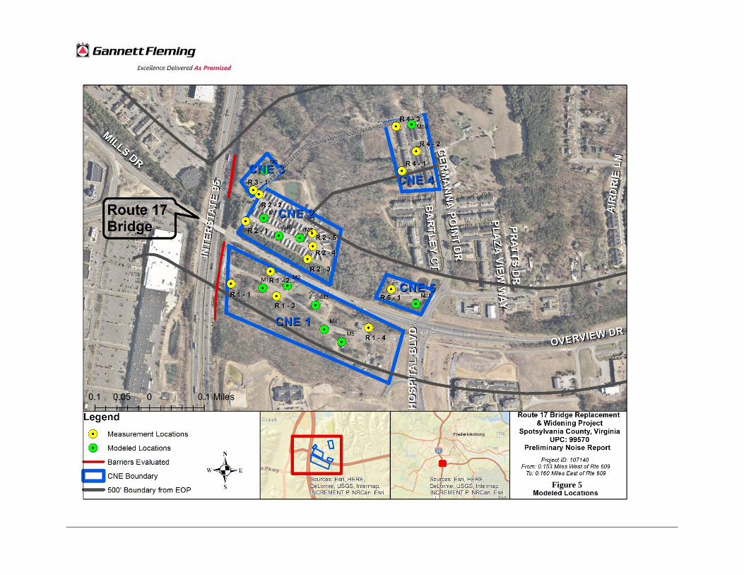
Figure 5

APPENDICES
Service Layer Credits: Sources: Esri, HERE,DeLorme, USGS, Intermap, INCREMENT P,NRCan, Esri Japan, METI, Esri China (HongKong), Esri Korea, Esri (Thailand),MapmyIndia, NGCC, © OpenStreetMapcontributors, and the GIS User Community
!.
!.
!.
!.
!.
!.
!.
!.
!.
!.
!.
!.
!.!. !.
!.
!.
!.
!.
!.
!.
!.
!.
!.
!.
MILLS DRMILLS DR
INTE
RSTA
TE 95
INTE
RSTA
TE 95
PRATTS DRPRATTS DR
OVERVIEW DR
OVERVIEW DR
GERMANNA POINT DRGERMANNA POINT DR
LOOKOUT LN
LOOKOUT LN
GLENWOOD CIR
GLENWOOD CIRBARTLEY CTBARTLEY CT
LEIGHANN LNLEIGHANN LNGL
ENWO
OD D
R
GLEN
WOOD
DR
LEE HILL SCHOOL DRLEE HILL SCHOOL DR
OVERVIEW DROVERVIEW DR
M9
M8
M7
M6
M5
M4
M3
M2M1
M11
0 250 500 750 1,000125Feet
Legend!. Impacted & Not Benefited!. Not impacted & Not Benefited
66 dB500' Boundary from EOPCNE Boundary
CNE 1CNE 1
CNE 2CNE 2
CNE 3CNE 3
CNE 5CNE 5
.Route 17 Bridge Replacement
& Widening ProjectSpotsylvania County, Virginia
UPC: 107140Preliminary Noise Report
Figure 666 dB(A) Contour
Project ID: 0017-088-R72From: Intersection with US Rte 1
To: 0.9 Miles S. of Intersection with US Rte 1
Sourc
e:Ae
rialIm
ageE
SRI
CNE 4CNE 4

APPENDICES

APPENDIX A
Short-term Measurements Field Data Sheets


APPENDIX B
Noise Meters Certification of Calibration

Seiln_A In&. CALIBRATION LABORATORY
ISO 17025: 2005, ANSI/NCSL Z540:1994 Part 1
ACCREDITED by NVLAP (an ILAC MRA signatory) NVLAP Lab Code: 200625-0
Calibration Certificate No.36373
Instrument: Acoustical Calibrator Date Calibrated: 5/31/2016 Cal Due: 5/31/2017 Model: NC-74 Status: Received Sent
Manufacturer: Rion In tolerance: X X Serial number: 01200033_80289.000 Out of tolerance:
Class (lEC 60942): 1 See comments:
Barometer type: Contains non-accredited tests: _Yes .lL No Barometer sin: Customer: Environmental Acoustics, Inc. Address: 1400 Hummel Avenue Tel/Fax: 717-737-4680/717-737-4685 Lemoyne, PA 17043
Tested in accordance with the following procedures and standards: Calibration of Acoustical Calibrators, Scantek Inc., Rev. 1/16/2015
Instrumentation used for calibration: Nor-1504 Norsonic Test System:
Instrument - Manufacturer Description SIN Cal. Date Traceability evidence
Cal. Due Cal. lab / Accreditation
483B-Norsonic SMECal Unit 31052 Oct 23,2015 Scantek, Inc./ NVLAP Oct 23,2016
,DS-360-SRS Function Generator 33584 Oct 20, 2015 ACR Env./ A2LA Oct 20, 2017
!344OlA-Agilent Technologies Digital Voltmeter US36120731 Oct 6, 2015 ACR Env.1 A2LA Oct 6, 2016
HM30-Thommen Meteo Station 1040170/39633 Oct 23, 2015 ACR Env./ A2LA Oct 23, 2016
140-Norsonic Real Time Analyzer 1406424 Oct 26,2015 Scantek / NVLAP Oct 26, 2016
PC Program 1018 Norsonic Calibration software v.6.n Validated Nov
2014 Scantek, Inc. -
4134-Briiel&Kjcer Microphone 173368 Nov 10, 2015 Scantek, Inc. I NVLAP Nov 10,2016
1203-Norsonic Preamplifier 14052 Aug 24,2015 Scantek, Inc./ NVLAP Aug24,2016
Instrumentation and test results are traceable to 51 (International System of Units) through standards maintained by NIST (USA) and NPL (UK)
Calibrated by: Signature
Date
Authorized signatory:
Signature
Date
Calibration Certificates or Test Reports shall not be reproduced, except in full, without written approval of the laboratory. This Calibration Certificate or Test Reports shall not be used to claim product certification, approval or endorsement by NVLAP, NIST, or any agency of the federal government. Document stored as: Z:\Calibration Lab\CaI2016\RiONNC74-O.Sin_01200033_Ml.doc Page 1 of 2

SCIInte1l1 Inc. CALIBRATION LABORATORY ~W~£@®
ISO 17025: 2005, ANSI/NCSL Z540:1994 Part 1 CALIBRATION ~ AeCREDITED by NVLAP (an ILAC MRA signatory) NVLAP Lab Code: 200625-0
Calibration Certificate NO.37417
Model: Spark 706 Status: Manufacturer: Larson Davis In tolerance: Serial number: 01595 Out of tolerance: Tested with: Microphone MPR002 sIn 80565 See comments:
Instrument: Noise Dosimeter I SLM Date Calibrated:11/30/2016 Cal Due: 11/30/2017
•
I
Received Sent x x
ID number: 80389.000 Contains non-accredited tests: _Yes lL No Type (class): 2 Calibration service: Basic lL Standard Customer: Environmental Acoustics Address: 1400 Hummel Avenue
Lemoyne, PA 17403-1749Tel/Fax: 717-730-4680 I -730-4685
Tested in accordance with the followlnR procedures and standards: Calibration of Sound Level Meters, Scantek Inc., Rev. 6/26/2015 SLM & Dosimeters - Acoustical Tests, Scantek Inc., Rev. 7/6/2011
Instrumentation used for calibration: Nor-1504 Norsonic Test System:
Instrument - Manufacturer Description SIN Cal. Date Traceability evidence
Cal. Lab I Accreditation Cal. Due
483B-Norsonic SME Cal Unit 31061 lui 27, 2016 Scantek, Inc./ NVLAP lui 27, 2017
DS-360-SRS Function Generator 88077 Sep 15, 2016 ACR Env./ A2LA Sep 15, 2018 i
34401A-Agilent Technologies Digital Voltmeter MY47011118 Sep 15, 2016 ACR Env./ A2LA Sep 15, 2017 I
HM30-Thommen Meteo Station 1040170/39633 Nov 1, 2016 ACR Env./ A2LA Nov 1, 2017
PC Program 1019 Norsonic Calibration software v.6.1T Validated Nov 2014
Scantek, Inc. i-
1251-Norsonic Calibrator 30878 Nov 10,2016 Scantek, Inc./ NVLAP Nov 10, 2017 I 4226-Bruel&Kj<er Multifunction calibrator 2305103 lui 25, 2016 Scantek, Inc./ NVLAP Jul 25, 2017
Instrumentation and test results are traceable to SI (International System of Units) through standards maintained by NIST (USA) and NPL (UK).
Environmental conditions:
Temperature (.C) Barometric pressure (kPa) Relative Humidity (%)
23.9 99.08 45.9
Calibrated by:
Signature
Date
Authorized signatory: Steven E. Marshall
Signature
Date
Calibration Certificates or Test Reports shall not be reproduced, except in full, without written approval of the laboratory, This Calibration Certificate or Test Reports shall not be used to claim product certification, approval or endorsement by NVLAP, NISI, or any agency of the federal government. Document stored Z:\Calibration Lab\SLM 2016\LDSP706_01595_M2.doc Page 1 of 2
SCilntell!l Inc. CALIBRATION LABORATORY ~W~£@®
ISO 17025: 2005, ANSI/NCSL Z540:1994 Part 1 CALIBRATION ~ ACCREDITED by NVLAP (an ILAC MRA signatory) NVLAP Lab Code: 200625-0
Calibration Certificate No.37416 Instrument: Noise Dosimeter I SLM Date Calibrated:12/1/2016 Cal Due: 12/1/2017 Model: Spark 706 Status: Received Sent Manufacturer: Larson Davis In tolerance: X X Serial number: 01596 Out of tolerance: Tested with: Microphone MPR002 sIn 80404 See comments: IDnumber: 80390.000 Contains non-accredited tests: _Yes lL No Type (class): 2 Calibration service: Basic lL Standard Customer: Environmental Acoustics Address: 1400 Hummel Avenue
Tel/Fax: 717-730-4680/-4685 Lemoyne, PA 17403-1749
Tested in accordance with the foliowinR procedures and standards: Calibration of Sound Level Meters, Scantek Inc., Rev. 6/26/2015 SLM & Dosimeters - Acoustical Tests, Scantek Inc., Rev. 7/6/2011
Instrumentation used for calibration: Nor-1504 Norsonic Test System:
Traceability evidence Instrument· Manufacturer Description Cal. Date Cal. Due SIN
Cal. Lab I Accreditation
483B-Norsonic Ju127,2016SME Cal Unit 31061 Scantek, Inc./ NVLAP Ju127,2017
DS-360-SRS Sep 15, 2016 Function Generator 88077 ACR Env./ A2LA
34401A-Agilent Technologies Digital Voltmeter MY47011118 Sep 15, 2016 ACR Env./ A2LA
HM30-Thommen Nov 1, 2016 ACR Env./ A2LA 1040170/39633
ValidatedPC Program 1019 Norsonic v.6.1T Scantek, Inc.
Nov 2014
1251-Norsonic Nov 10, 2016 30878 Scantek, Inc./ NVLAP
4226-Bruel&Kjaer JuI2S, 2016 Scantek, Inc./ NVLAP
Instrumentation and test results are traceable to SI (International System of Units) through standards maintained by NIST (USA) and NPL (UK).
Environmental conditions:
Temperature ("C) Barometric pressure (kPa) Relative Humidity (%)
24.4 99.26 37.5
Calibrated by:
Signature
Date
Authorized signatory:
Signature
Date
Calibration Certificates or Test Reports shall not be reproduced, except in full, without written approval of the laboratory. This Calibration Certificate or Test Reports shall not be used to claim product certification, approval or endorsement by NVLAP, NIST, or any agency of the federal government. Document stored Z;\Calibration Lab\SLM 2016\LDSP706_01S96_M1.doc Page 1 of 2

Sc.rnll!/£ In&. CALIBRATION LABORATORY
ISO 17025: 2005, ANSI/NCSL Z540:1994 Part 1
ACCREDITED by NVLAP (an ILAC MRA signatory)
NVLAP Lab Code: 200625-0
Calibration C~rtificate NO.36194 Instrument: Sound level Meter Date Calibrated: 5/10/2016 Cal Due: 5/10/2017
I :
Model: NA28 Status: Manufacturer: Rion In tolerance: Serial number: 00870496 ID Number: 80430.000 Out of tolerance:
Tested with: Microphone UC-59 sIn 04607 See comments:
Received Sent X X
Preamplifier NH23 sIn 70511 Contains non-accredited tests: Yes X No Type (class): 1 Calibration service: Basic lL Standard Customer: Environmental Acoustics Address: 1400 Hummel Avenue
Tel/Fax: 717-730-4680/-4685 lemoyne, PA. 17043
Tested in accordance with the following procedures and standards: Calibration of Sound Level Meters, Scantek Inc., Rev. 6/26/2015 SLM & Dosimeters Acoustical Tests, Scantek Inc., Rev. 7/6/2011
Instrumentation used for calibration: Nor-1504 Norsonic Test System:
Instrument· Manufacturer I Description SIN Cal. Date Traceability evidence #,10"Cal. Lab / Accreditation
483B-Norsonic SMECal Unit 31061 Jul 20, 2015 Scantek, Inc./ NVLAP 20,2016
DS-360-SRS Function Generator 88077 Sep 9, 2014 ACR Env./ A2LA Sep 9, 2016
34401A-Agilent Technologies Digital Voltmeter MY47011118 Sep 24, 2015 ACR Env./ A2LA I Sep 24, 2016
HM30-Thommen Meteo Station 1040170/39633 Oct 23, 2015 ACR Env./ A2LA Oct 23,2016
PC Program 1019 Norsonic Calibration software v.6.1T Validated Nov
2014 Scantek, Inc.
1251-Norsonic Calibrator 30878 Nov 10, 2015 Scantek, Inc./ NVLAP Nov 10, 2016
Instrumentation and test results are traceable to SI (International System of Units) through standards maintained by NIST (USA) and NPl (UK).
Environmental conditions:
Temperature rq Barometric pressure (kPa) Relative Humidity (%)
23.7 100.89 42.6
Calibrated by:
Signature
Date
Authorized signatory: Signature
Date
Calibration Certificates or Test Reports shall not be reproduced, except in full, without written approval of the laboratory. This Calibration Certificate or Test Reports shall not be used to claim product certification, approval or endorsement by NVLAP, NIST, or any agency of the federal government. Document stored Z:\Calibration Lab\SLM 2016\Riona28_00870496_Ml.doc Page 1 of 2

SCllllell/£ III&. CALIBRATION LABORATORY
ISO 17025: 2005, ANSI/NCSL Z540:1994 Part 1
ACCREDITED by NVLAP (an I LAC MRA signatory)
NVLAP Lab Code: 20062$-0
Calibration Certificate NO.36371 Instrument: Sound Level Meter Date Calibrated:6/i/2016 Cal Due: 6/1/2017 Model: NA28 Status: Received Sent Manufacturer: Rion In talerance: X X Serial number: 01170630. Out of tolerance: IDnumber: 80427.000 Tested with: Microphone UC-59 sIn 04608 See comments:
Preamplifier NH23 sIn 70648 Contains non-accredited tests: Yes 1L No Type (class): 1 Calibration service: Basic 1L Standard Customer: Environmental Acoustics, Inc. Address: 1400 Hummel Avenue
Tel/Fax: 717-737-4680/717-737-4685 Lemoyne, PA 17043
Tested in accordance with the following procedures and standards: Calibration of Sound Level Meters, Scantek Inc., Rev. 6/26/2015 SLM & Dosimeters - AcousticalTests, Scantek Inc., Rev. 7/6/2011
Instrumentation used for calibration: Nor-1504 Norsonic Test System:
Instrument - Manufacturer Description SIN Cal. Date Traceability evidence
Cal. Due Cal. Lab I Accreditation
483B-Norsonic SME Cal Unit 31052 Oct 23,2015 Scantek, Inc./ NVLAP Oct 23,2016
DS-360-SRS Function Generator 33584 Oct. 20, 2015 ACR Env./ A2LA Oct 20,2017
34401A-Agilent Technologies Digital Voltmeter US36120731 Oct 6,2015 ACR Env. / A2LA Oct 6,2016
H M30-Thommen Meteo Station 1040170/39633 Oct 23,2015 ACR Env./ A2LA Oct 23,2016
PC Program 1019 Norsonic Calibration software v.6.1T Validated Nov
2014 Scantek, Inc. -
1251-Norsonic Calibrator 30878 Nov 10, 2015 Scantek, Inc./ NVLAP Nov 10,2016
Instrumentation and test results are traceable to SI (International System of Units) through standards maintained by NIST (USA) and NPL (UK).
Environmental conditions:
Temperature (oq Barometric pressure (kPa) Relative Humidity (%)
24.0 100.25 49.4
Calibrated by: Signature
Date
Authorized signatory: ga Signature
Date
Calibration Certificates or Test Reports shall not be reproduced, except in full, without written approval of the laboratory. This Calibration Certificate or Test Reports shall not be used to claim product certification, approval or endorsement by NVLAP, NIST, or any agency of the federal government. Document stored Z:\Calibration lab\SlM 2016\Riona28_01l70630_80427 OOO_M1.doc Page 1 of 2

APPENDIX C Spotsylvania County Planning Department Correspondence


APPENDIX D
Traffic Data

ADT DHV Peak Auto MT HT
2014 23000 1977 1980 1841 40 99
2040 38400 3300 3280 3050 66 164
ADT DHV Peak Auto MT HT
2014 97800 8383 8690 7387 174 1130
2040 140000 12000 11958 10164 239 1555
From the Traffic data
Rte 17
I‐95
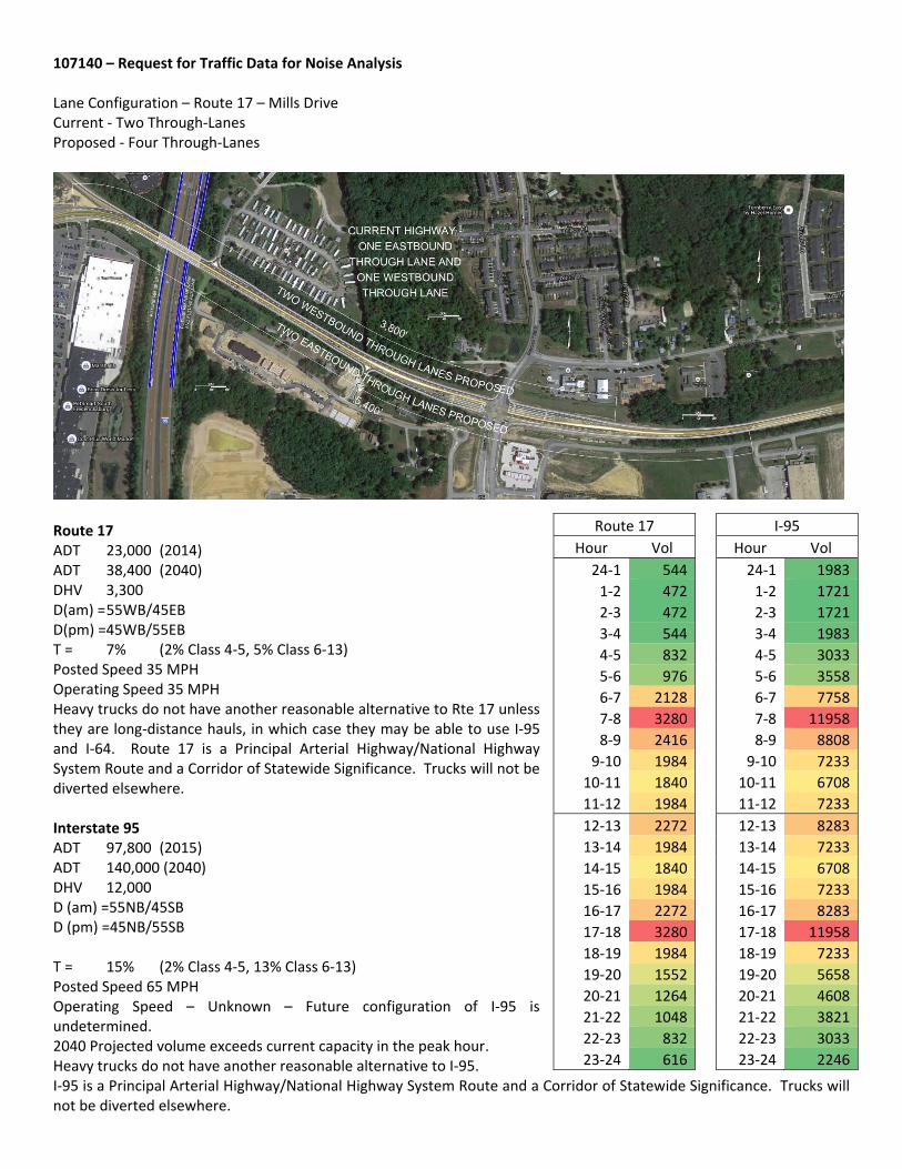
107140 – Request for Traffic Data for Noise Analysis Lane Configuration – Route 17 – Mills Drive Current ‐ Two Through‐Lanes Proposed ‐ Four Through‐Lanes
Route 17 ADT 23,000 (2014) ADT 38,400 (2040) DHV 3,300 D(am) = 55WB/45EB D(pm) =45WB/55EB T = 7% (2% Class 4‐5, 5% Class 6‐13) Posted Speed 35 MPH Operating Speed 35 MPH Heavy trucks do not have another reasonable alternative to Rte 17 unless they are long‐distance hauls, in which case they may be able to use I‐95 and I‐64. Route 17 is a Principal Arterial Highway/National Highway System Route and a Corridor of Statewide Significance. Trucks will not be diverted elsewhere. Interstate 95 ADT 97,800 (2015) ADT 140,000 (2040) DHV 12,000 D (am) =55NB/45SB D (pm) =45NB/55SB T = 15% (2% Class 4‐5, 13% Class 6‐13) Posted Speed 65 MPH Operating Speed – Unknown – Future configuration of I‐95 is undetermined. 2040 Projected volume exceeds current capacity in the peak hour. Heavy trucks do not have another reasonable alternative to I‐95. I‐95 is a Principal Arterial Highway/National Highway System Route and a Corridor of Statewide Significance. Trucks will not be diverted elsewhere.
I‐95
Hour Vol
24‐1 1983
1‐2 1721
2‐3 1721
3‐4 1983
4‐5 3033
5‐6 3558
6‐7 7758
7‐8 11958
8‐9 8808
9‐10 7233
10‐11 6708
11‐12 7233
12‐13 8283
13‐14 7233
14‐15 6708
15‐16 7233
16‐17 8283
17‐18 11958
18‐19 7233
19‐20 5658
20‐21 4608
21‐22 3821
22‐23 3033
23‐24 2246
Route 17
Hour Vol
24‐1 544
1‐2 472
2‐3 472
3‐4 544
4‐5 832
5‐6 976
6‐7 2128
7‐8 3280
8‐9 2416
9‐10 1984
10‐11 1840
11‐12 1984
12‐13 2272
13‐14 1984
14‐15 1840
15‐16 1984
16‐17 2272
17‐18 3280
18‐19 1984
19‐20 1552
20‐21 1264
21‐22 1048
22‐23 832
23‐24 616

Germanna Point Drive ‐ Southern End (near Rte 17) The Northern and Southern segments of Germanna Point Drive break at Colonnade Way ADT 5,100 (2014) ADT 7,400 (2040) DHV 700 Posted Speed 25 MPH Operating Speed 25 MPH Approximate Truck % is 3% (1% + 2%) D (am) = 60SB/40NB D (pm) = 40SB/60NB Germanna Point Drive – Northern End (near Community College) ADT 3,000 (2014) ADT 5,000 (2040) DHV 450 Posted Speed 25 MPH Operating Speed 25 MPH Approximate Truck % is 3% (1% + 2%) D = 60/40 No other data is available. No data is available for Hospital Blvd.
Germanna Pt Dr N
Hour Vol
24‐1 56
1‐2 45
2‐3 45
3‐4 56
4‐5 97
5‐6 118
6‐7 285
7‐8 451
8‐9 326
9‐10 264
10‐11 243
11‐12 264
12‐13 306
13‐14 264
14‐15 243
15‐16 264
16‐17 306
17‐18 451
18‐19 264
19‐20 201
20‐21 160
21‐22 128
22‐23 97
23‐24 66
Germanna Pt Dr S
Hour Vol
24‐1 82
1‐2 67
2‐3 67
3‐4 82
4‐5 144
5‐6 175
6‐7 421
7‐8 668
8‐9 483
9‐10 391
10‐11 360
11‐12 391
12‐13 452
13‐14 391
14‐15 360
15‐16 391
16‐17 452
17‐18 668
18‐19 391
19‐20 298
20‐21 236
21‐22 190
22‐23 144
23‐24 98

APPENDIX E
Warranted, Feasible and Reasonable Worksheets

73 Highway Traffic Noise Manual Updated: March 31, 2014
Appendix E Warranted, Feasible, and Reasonable Worksheet
Note: the answers provided in the worksheet may differ between preliminary and final design. This worksheet is available in a protected digital format upon request.
Date: 5/31/2017 Project No. and UPC: County: Facility: Barrier System ID: Noise Abatement Category(s) Community Name and/or CNE#
Design phase: Preliminary Design Final Design
Warranted 1. Community Documentation (if applicable)
a. Date community was permitted. (Per 23CFR 772 this isthe date the building permit was issued).
b. Date of approval for the Categorical Exclusion (CE),Record of Decision (ROD), or Finding of No SignificantImpact (FONSI):
c. Does the date in 1.a precede the date in 1.b? If yes,proceed to Warranted Item 2. If no, consideration ofnoise abatement is not warranted. Proceed to “Decision”block and answer “no” to warranted question. As thereason for this decision, state that “Community waspermitted after the date of approval of CE, ROD, orFONSI, as appropriate.”
Yes No
2. Criteria requiring consideration of noise abatementa. Project causes design year noise levels to approach or
exceed the Noise Abatement Criteria?b. Project causes a substantial noise increase of 10 dBA or
more?
Yes No
Yes No
Feasibility 1. Impacted receptor units
a. Number of impacted receptor units:b. Number of impacted receptor units receiving 5 dBA or
more insertion loss (IL):c. Percentage of impacted receptor units receiving 5 dB(A)
or more ILd. Is the percentage 50 or greater? Yes No
0017-088-R72, B616, P101 UPC 107140Spotsylvania
BCNE 1
X
X
X
1
1
100%
X
74 Highway Traffic Noise Manual Updated: March 31, 2014
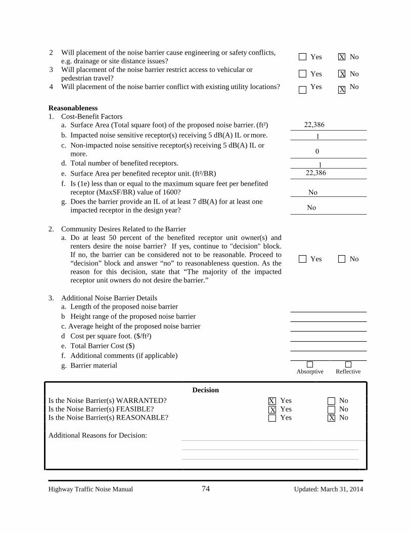
2 Will placement of the noise barrier cause engineering or safety conflicts, e.g. drainage or site distance issues?
3 Will placement of the noise barrier restrict access to vehicular or pedestrian travel?
Yes No
Yes No
4 Will placement of the noise barrier conflict with existing utility locations? Yes No
Reasonableness 1. Cost-Benefit Factors
a. Surface Area (Total square foot) of the proposed noise barrier. (ft²)b. Impacted noise sensitive receptor(s) receiving 5 dB(A) IL or more.c. Non-impacted noise sensitive receptor(s) receiving 5 dB(A) IL or
more.d. Total number of benefited receptors.e. Surface Area per benefited receptor unit. (ft²/BR)f. Is (1e) less than or equal to the maximum square feet per benefited
receptor (MaxSF/BR) value of 1600?g. Does the barrier provide an IL of at least 7 dB(A) for at least one
impacted receptor in the design year?
2. Community Desires Related to the Barriera. Do at least 50 percent of the benefited receptor unit owner(s) and
renters desire the noise barrier? If yes, continue to "decision" block.If no, the barrier can be considered not to be reasonable. Proceed to“decision” block and answer “no” to reasonableness question. As thereason for this decision, state that “The majority of the impactedreceptor unit owners do not desire the barrier.”
Yes No
3. Additional Noise Barrier Detailsa. Length of the proposed noise barrierb Height range of the proposed noise barrierc. Average height of the proposed noise barrierd Cost per square foot. ($/ft²)e. Total Barrier Cost ($)f. Additional comments (if applicable)g. Barrier material
Absorptive Reflective
Decision Is the Noise Barrier(s) WARRANTED? Yes No Is the Noise Barrier(s) FEASIBLE? Yes No Is the Noise Barrier(s) REASONABLE? Yes No
Additional Reasons for Decision:
X
X
X
22,3861
0
122,386
No
No
XX
X

73 Highway Traffic Noise Manual Updated: March 31, 2014
Appendix E Warranted, Feasible, and Reasonable Worksheet
Note: the answers provided in the worksheet may differ between preliminary and final design. This worksheet is available in a protected digital format upon request.
Date: 5/31/2017 Project No. and UPC: County: Facility: Barrier System ID: Noise Abatement Category(s) Community Name and/or CNE#
Design phase: Preliminary Design Final Design
Warranted 1. Community Documentation (if applicable)
a. Date community was permitted. (Per 23CFR 772 this isthe date the building permit was issued).
b. Date of approval for the Categorical Exclusion (CE),Record of Decision (ROD), or Finding of No SignificantImpact (FONSI):
c. Does the date in 1.a precede the date in 1.b? If yes,proceed to Warranted Item 2. If no, consideration ofnoise abatement is not warranted. Proceed to “Decision”block and answer “no” to warranted question. As thereason for this decision, state that “Community waspermitted after the date of approval of CE, ROD, orFONSI, as appropriate.”
Yes No
2. Criteria requiring consideration of noise abatementa. Project causes design year noise levels to approach or
exceed the Noise Abatement Criteria?b. Project causes a substantial noise increase of 10 dBA or
more?
Yes No
Yes No
Feasibility 1. Impacted receptor units
a. Number of impacted receptor units:b. Number of impacted receptor units receiving 5 dBA or
more insertion loss (IL):c. Percentage of impacted receptor units receiving 5 dB(A)
or more ILd. Is the percentage 50 or greater? Yes No
0017-088-R72, B616, P101 UPC 107140Spotsylvania
BCNE 2
X
X
X

74 Highway Traffic Noise Manual Updated: March 31, 2014
2 Will placement of the noise barrier cause engineering or safety conflicts, e.g. drainage or site distance issues?
3 Will placement of the noise barrier restrict access to vehicular or pedestrian travel?
Yes No
Yes No
4 Will placement of the noise barrier conflict with existing utility locations? Yes No
Reasonableness 1. Cost-Benefit Factors
a. Surface Area (Total square foot) of the proposed noise barrier. (ft²)b. Impacted noise sensitive receptor(s) receiving 5 dB(A) IL or more.c. Non-impacted noise sensitive receptor(s) receiving 5 dB(A) IL or
more.d. Total number of benefited receptors.e. Surface Area per benefited receptor unit. (ft²/BR)f. Is (1e) less than or equal to the maximum square feet per benefited
receptor (MaxSF/BR) value of 1600?g. Does the barrier provide an IL of at least 7 dB(A) for at least one
impacted receptor in the design year?
2. Community Desires Related to the Barriera. Do at least 50 percent of the benefited receptor unit owner(s) and
renters desire the noise barrier? If yes, continue to "decision" block.If no, the barrier can be considered not to be reasonable. Proceed to“decision” block and answer “no” to reasonableness question. As thereason for this decision, state that “The majority of the impactedreceptor unit owners do not desire the barrier.”
Yes No
3. Additional Noise Barrier Detailsa. Length of the proposed noise barrierb Height range of the proposed noise barrierc. Average height of the proposed noise barrierd Cost per square foot. ($/ft²)e. Total Barrier Cost ($)f. Additional comments (if applicable)g. Barrier material
Absorptive Reflective
Decision Is the Noise Barrier(s) WARRANTED? Yes No Is the Noise Barrier(s) FEASIBLE? Yes No Is the Noise Barrier(s) REASONABLE? Yes No
Additional Reasons for Decision:
X

73 Highway Traffic Noise Manual Updated: March 31, 2014
Appendix E Warranted, Feasible, and Reasonable Worksheet
Note: the answers provided in the worksheet may differ between preliminary and final design. This worksheet is available in a protected digital format upon request.
Date: 5/31/2017 Project No. and UPC: County: Facility: Barrier System ID: Noise Abatement Category(s) Community Name and/or CNE#
Design phase: Preliminary Design Final Design
Warranted 1. Community Documentation (if applicable)
a. Date community was permitted. (Per 23CFR 772 this isthe date the building permit was issued).
b. Date of approval for the Categorical Exclusion (CE),Record of Decision (ROD), or Finding of No SignificantImpact (FONSI):
c. Does the date in 1.a precede the date in 1.b? If yes,proceed to Warranted Item 2. If no, consideration ofnoise abatement is not warranted. Proceed to “Decision”block and answer “no” to warranted question. As thereason for this decision, state that “Community waspermitted after the date of approval of CE, ROD, orFONSI, as appropriate.”
Yes No
2. Criteria requiring consideration of noise abatementa. Project causes design year noise levels to approach or
exceed the Noise Abatement Criteria?b. Project causes a substantial noise increase of 10 dBA or
more?
Yes No
Yes No
Feasibility 1. Impacted receptor units
a. Number of impacted receptor units:b. Number of impacted receptor units receiving 5 dBA or
more insertion loss (IL):c. Percentage of impacted receptor units receiving 5 dB(A)
or more ILd. Is the percentage 50 or greater? Yes No
0017-088-R72, B616, P101 UPC 107140Spotsylvania
BCNE 3
X
X
X
1
1
100%
X

74 Highway Traffic Noise Manual Updated: March 31, 2014
2 Will placement of the noise barrier cause engineering or safety conflicts, e.g. drainage or site distance issues?
3 Will placement of the noise barrier restrict access to vehicular or pedestrian travel?
Yes No
Yes No
4 Will placement of the noise barrier conflict with existing utility locations? Yes No
Reasonableness 1. Cost-Benefit Factors
a. Surface Area (Total square foot) of the proposed noise barrier. (ft²)b. Impacted noise sensitive receptor(s) receiving 5 dB(A) IL or more.c. Non-impacted noise sensitive receptor(s) receiving 5 dB(A) IL or
more.d. Total number of benefited receptors.e. Surface Area per benefited receptor unit. (ft²/BR)f. Is (1e) less than or equal to the maximum square feet per benefited
receptor (MaxSF/BR) value of 1600?g. Does the barrier provide an IL of at least 7 dB(A) for at least one
impacted receptor in the design year?
2. Community Desires Related to the Barriera. Do at least 50 percent of the benefited receptor unit owner(s) and
renters desire the noise barrier? If yes, continue to "decision" block.If no, the barrier can be considered not to be reasonable. Proceed to“decision” block and answer “no” to reasonableness question. As thereason for this decision, state that “The majority of the impactedreceptor unit owners do not desire the barrier.”
Yes No
3. Additional Noise Barrier Detailsa. Length of the proposed noise barrierb Height range of the proposed noise barrierc. Average height of the proposed noise barrierd Cost per square foot. ($/ft²)e. Total Barrier Cost ($)f. Additional comments (if applicable)g. Barrier material
Absorptive Reflective
Decision Is the Noise Barrier(s) WARRANTED? Yes No Is the Noise Barrier(s) FEASIBLE? Yes No Is the Noise Barrier(s) REASONABLE? Yes No
Additional Reasons for Decision:
X
X
X
11,7361
0
111,736
No
Yes
XX
X

73 Highway Traffic Noise Manual Updated: March 31, 2014
Appendix E Warranted, Feasible, and Reasonable Worksheet
Note: the answers provided in the worksheet may differ between preliminary and final design. This worksheet is available in a protected digital format upon request.
Date: 5/31/2017 Project No. and UPC: County: Facility: Barrier System ID: Noise Abatement Category(s) Community Name and/or CNE#
Design phase: Preliminary Design Final Design
Warranted 1. Community Documentation (if applicable)
a. Date community was permitted. (Per 23CFR 772 this isthe date the building permit was issued).
b. Date of approval for the Categorical Exclusion (CE),Record of Decision (ROD), or Finding of No SignificantImpact (FONSI):
c. Does the date in 1.a precede the date in 1.b? If yes,proceed to Warranted Item 2. If no, consideration ofnoise abatement is not warranted. Proceed to “Decision”block and answer “no” to warranted question. As thereason for this decision, state that “Community waspermitted after the date of approval of CE, ROD, orFONSI, as appropriate.”
Yes No
2. Criteria requiring consideration of noise abatementa. Project causes design year noise levels to approach or
exceed the Noise Abatement Criteria?b. Project causes a substantial noise increase of 10 dBA or
more?
Yes No
Yes No
Feasibility 1. Impacted receptor units
a. Number of impacted receptor units:b. Number of impacted receptor units receiving 5 dBA or
more insertion loss (IL):c. Percentage of impacted receptor units receiving 5 dB(A)
or more ILd. Is the percentage 50 or greater? Yes No
0017-088-R72, B616, P101 UPC 107140Spotsylvania
BCNE 4
X
X
X

74 Highway Traffic Noise Manual Updated: March 31, 2014
2 Will placement of the noise barrier cause engineering or safety conflicts, e.g. drainage or site distance issues?
3 Will placement of the noise barrier restrict access to vehicular or pedestrian travel?
Yes No
Yes No
4 Will placement of the noise barrier conflict with existing utility locations? Yes No
Reasonableness 1. Cost-Benefit Factors
a. Surface Area (Total square foot) of the proposed noise barrier. (ft²)b. Impacted noise sensitive receptor(s) receiving 5 dB(A) IL or more.c. Non-impacted noise sensitive receptor(s) receiving 5 dB(A) IL or
more.d. Total number of benefited receptors.e. Surface Area per benefited receptor unit. (ft²/BR)f. Is (1e) less than or equal to the maximum square feet per benefited
receptor (MaxSF/BR) value of 1600?g. Does the barrier provide an IL of at least 7 dB(A) for at least one
impacted receptor in the design year?
2. Community Desires Related to the Barriera. Do at least 50 percent of the benefited receptor unit owner(s) and
renters desire the noise barrier? If yes, continue to "decision" block.If no, the barrier can be considered not to be reasonable. Proceed to“decision” block and answer “no” to reasonableness question. As thereason for this decision, state that “The majority of the impactedreceptor unit owners do not desire the barrier.”
Yes No
3. Additional Noise Barrier Detailsa. Length of the proposed noise barrierb Height range of the proposed noise barrierc. Average height of the proposed noise barrierd Cost per square foot. ($/ft²)e. Total Barrier Cost ($)f. Additional comments (if applicable)g. Barrier material
Absorptive Reflective
Decision Is the Noise Barrier(s) WARRANTED? Yes No Is the Noise Barrier(s) FEASIBLE? Yes No Is the Noise Barrier(s) REASONABLE? Yes No
Additional Reasons for Decision:
X

73 Highway Traffic Noise Manual Updated: March 31, 2014
Appendix E Warranted, Feasible, and Reasonable Worksheet
Note: the answers provided in the worksheet may differ between preliminary and final design. This worksheet is available in a protected digital format upon request.
Date: 5/31/2017 Project No. and UPC: County: Facility: Barrier System ID: Noise Abatement Category(s) Community Name and/or CNE#
Design phase: Preliminary Design Final Design
Warranted 1. Community Documentation (if applicable)
a. Date community was permitted. (Per 23CFR 772 this isthe date the building permit was issued).
b. Date of approval for the Categorical Exclusion (CE),Record of Decision (ROD), or Finding of No SignificantImpact (FONSI):
c. Does the date in 1.a precede the date in 1.b? If yes,proceed to Warranted Item 2. If no, consideration ofnoise abatement is not warranted. Proceed to “Decision”block and answer “no” to warranted question. As thereason for this decision, state that “Community waspermitted after the date of approval of CE, ROD, orFONSI, as appropriate.”
Yes No
2. Criteria requiring consideration of noise abatementa. Project causes design year noise levels to approach or
exceed the Noise Abatement Criteria?b. Project causes a substantial noise increase of 10 dBA or
more?
Yes No
Yes No
Feasibility 1. Impacted receptor units
a. Number of impacted receptor units:b. Number of impacted receptor units receiving 5 dBA or
more insertion loss (IL):c. Percentage of impacted receptor units receiving 5 dB(A)
or more ILd. Is the percentage 50 or greater? Yes No
0017-088-R72, B616, P101 UPC 107140Spotsylvania
BCNE 5
X
X
X

74 Highway Traffic Noise Manual Updated: March 31, 2014
2 Will placement of the noise barrier cause engineering or safety conflicts, e.g. drainage or site distance issues?
3 Will placement of the noise barrier restrict access to vehicular or pedestrian travel?
Yes No
Yes No
4 Will placement of the noise barrier conflict with existing utility locations? Yes No
Reasonableness 1. Cost-Benefit Factors
a. Surface Area (Total square foot) of the proposed noise barrier. (ft²)b. Impacted noise sensitive receptor(s) receiving 5 dB(A) IL or more.c. Non-impacted noise sensitive receptor(s) receiving 5 dB(A) IL or
more.d. Total number of benefited receptors.e. Surface Area per benefited receptor unit. (ft²/BR)f. Is (1e) less than or equal to the maximum square feet per benefited
receptor (MaxSF/BR) value of 1600?g. Does the barrier provide an IL of at least 7 dB(A) for at least one
impacted receptor in the design year?
2. Community Desires Related to the Barriera. Do at least 50 percent of the benefited receptor unit owner(s) and
renters desire the noise barrier? If yes, continue to "decision" block.If no, the barrier can be considered not to be reasonable. Proceed to“decision” block and answer “no” to reasonableness question. As thereason for this decision, state that “The majority of the impactedreceptor unit owners do not desire the barrier.”
Yes No
3. Additional Noise Barrier Detailsa. Length of the proposed noise barrierb Height range of the proposed noise barrierc. Average height of the proposed noise barrierd Cost per square foot. ($/ft²)e. Total Barrier Cost ($)f. Additional comments (if applicable)g. Barrier material
Absorptive Reflective
Decision Is the Noise Barrier(s) WARRANTED? Yes No Is the Noise Barrier(s) FEASIBLE? Yes No Is the Noise Barrier(s) REASONABLE? Yes No
Additional Reasons for Decision:
X

APPENDIX F
References

References
• Procedures for Abatement of Highway Traffic Noise and Construction Noise 23 CFR 772. 2011.
• U.S. Department of Transportation, Federal Highway Administration, Highway
Traffic Noise: Analysis and Abatement Guidance, FHWA Report No. FHWA- HEP-10-025, December 2011.
• U.S. Department of Transportation, Federal Highway Administration,
Measurement of Highway-Related Noise FHWA Report No. FHWA-PD-96-046, May 1996.
• Virginia State Noise Abatement Policy
• Code of Virginia Noise Abatement Practices and technologies, Section 33.1-
223.2:21. 2013, (HB 2577).
• Virginia Department of Transportation, Highway Traffic Noise Impact Analysis Guidance Manual, approved March 15, 2011, effective July 13, 2011, updated July 14th, 2015.
• Virginia Department of Transportation, 2016 Road and Bridge Specifications,
Section 107.16(b.3) “Noise.”

APPENDIX G
List of Preparers/Reviewers
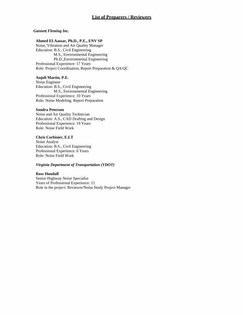
List of Preparers / Reviewers Gannett Fleming Inc.
Ahmed El-Aassar, Ph.D., P.E., ENV SP Noise, Vibration and Air Quality Manager Education: B.S., Civil Engineering
M.S., Environmental Engineering Ph.D.,Environmental Engineering
Professional Experience: 17 Years Role: Project Coordination, Report Preparation & QA/QC
Anjoli Martin, P.E. Noise Engineer Education: B.S., Civil Engineering
M.S., Environmental Engineering Professional Experience: 10 Years Role: Noise Modeling, Report Preparation
Sondra Peterson Noise and Air Quality Technician Education: A.S., CAD Drafting and Design Professional Experience: 19 Years Role: Noise Field Work
Chris Corbisier, E.I.T Noise Analyst Education: B.S., Civil Engineering Professional Experience: 6 Years Role: Noise Field Work Virginia Department of Transportation (VDOT)
Ross Hundall Senior Highway Noise Specialist Years of Professional Experience: 11 Role in the project: Reviewer/Noise Study Project Manager