Planning - Virginia Department of Transportation
136
Planning 1 | Virginia Department of Transportation 1 1- Planning Introduction Planning is the first step and key ingredient of any successful transportation system. In order for bicycling to become a viable mode of transportation at local, regional, and statewide levels, comprehensive bicycle plans need to be developed and adopted at the local or MPO level to gain regional and statewide significance. This chapter presents the bicycle planning process. Localities can use this chapter as a guide for creating a local bicycle plan or for updating an existing plan. It focuses on: ❚ What is a bicycle plan? ❚ Need for a plan ❚ Understanding bicycle facilities ❚ Developing a bicycle plan Some of the topics covered in this chapter are discussed in greater detail in following chapters of this resource guide. What is a Bicycle Plan? A bicycle plan needs to be recognized as a tool to incorporate bicycling into the transportation system. The plan describes how a locality or region intends to accommodate, encourage, and promote bicycling within its jurisdiction. It draws on a blend of existing and future bicycle facilities and programs to ensure a successful bicycle network. Bicycle plans in Virginia and elsewhere have historically varied widely in terms of content and format. While differences are to be expected, certain elements should be consistent among all plans. Ideally, a bicycle plan should be prepared to include the following information: ❚ goals and objectives ❚ existing bicycle facilities and roadway network ❚ planned bicycle and roadway improvements ❚ significant attractions and destination points ❚ routes and/or locations of proposed bicycle facilities, including ancillary facilities such as bike storage and racks ❚ indication of preferred facility type, such as wide outside lane, bike lane, and shared use path
Transcript of Planning - Virginia Department of Transportation

Planning 1
| Virginia Department of Transportation 11-
Planning
Introduction
Planning is the first step and key ingredient of any successful transportation system.In order for bicycling to become a viable mode of transportation at local, regional,and statewide levels, comprehensive bicycle plans need to be developed and adoptedat the local or MPO level to gain regional and statewide significance. This chapterpresents the bicycle planning process. Localities can use this chapter as a guide forcreating a local bicycle plan or for updating an existing plan. It focuses on:
❚ What is a bicycle plan?
❚ Need for a plan
❚ Understanding bicycle facilities
❚ Developing a bicycle plan
Some of the topics covered in this chapter are discussed in greater detail in followingchapters of this resource guide.
What is a Bicycle Plan?
A bicycle plan needs to be recognized as a tool to incorporate bicycling into thetransportation system. The plan describes how a locality or region intends toaccommodate, encourage, and promote bicycling within its jurisdiction. It draws on ablend of existing and future bicycle facilities and programs to ensure a successfulbicycle network. Bicycle plans in Virginia and elsewhere have historically variedwidely in terms of content and format. While differences are to be expected, certainelements should be consistent among all plans. Ideally, a bicycle plan should beprepared to include the following information:
❚ goals and objectives
❚ existing bicycle facilities and roadway network
❚ planned bicycle and roadway improvements
❚ significant attractions and destination points
❚ routes and/or locations of proposed bicycle facilities, including ancillary facilitiessuch as bike storage and racks
❚ indication of preferred facility type, such as wide outside lane, bike lane, and shareduse path

Planning1
2| Virginia Department of Transportation 1-
❚ prioritization of projects (short-term versus long-term)
❚ strategies for implementation including identifying potential funding sources,developing conceptual maintenance plans, and assigning operational tasks to agencies
❚ documentation of public involvement activities
❚ definitions and acronyms
❚ appendices and bibliography
Clearly written text should describe each one of the above noted elements. Whereappropriate, maps with legends should accompany the text to depict existing andproposed features. An easy to read map illustrating the plan can be a powerfulplanning tool and can be very helpful to agencies supporting particular projects.Photographs within the text and maps provide a relatively easy way of highlightingkey community resources discussed in the plan. To become an official planningdocument, the bicycle plan must be adopted locally or by a Metropolitan PlanningOrganization (MPO). It is up to the discretion of each individual locality to determinein what form the plan will be adopted. Acceptable options include incorporating itinto a comprehensive plan or a transportation plan or presenting it as a stand-alonedocument.
Need for a Plan
Based on the results of a mail back survey completed in 2000, only 21 percent oflocalities within Virginia have an adopted bicycle plan. Faced with growing interestand demands for bicycling facilities, the vast majority of those localities without aplan indicated an interest in developing one.
With bicycles representing just one part of the overall transportation system, the keyquestion is: How to provide for the safe accommodation of bicycles? This is where theplanning process begins. Creating a bicycle plan is important for many reasons including:
❚ establishing a long-term strategy for bicycle accommodation
❚ increasing the ability to leverage funding for bicycle facilities
❚ generating community support and enthusiasm
❚ contributing to more healthy communities
Long-term StrategyCreating an interconnected and coherent bicycle network requires a long-termcommitment and a comprehensive vision that are beyond the often times ad-hoc,piecemeal approach. Just as localities plan for their network of roadways, parks,

Planning 1
| Virginia Department of Transportation 31-
utilities, etc., they should also plan for their bicycle network. An adoptedcomprehensive plan is typically the “blueprint” for localities as they plan for futureinfrastructure, transportation improvements, open space, recreation, demographicchanges, and land use changes. A bicycle plan can and should be considered animportant element of a locality’s comprehensive plan.
The defining elements of most plans are their goals and objectives. In an ideal world,each locality would have enough funding to implement every project desired by thecommunity. Given the reality of limited resources, goals and objectives serve as thelitmus by which localities are able to identify and prioritize projects and programs.With the direction provided by a bicycle plan, a locality can organize its efforts andexpenditures over the course of many years in order to reach the desired goals andobjectives for bicycle accommodation.
Leverage FundingA locality or MPO must have an adopted bicycle plan before the VirginiaDepartment of Transportation (VDOT) will consider constructingbicycle facilities as part of their highway construction projects withinthat jurisdiction. This policy is a reflection of VDOT’s desire to commitresources in a manner consistent with local policies and plans regardingbicycling. In addition, being identified as part of an adopted bicycleplan is a criteria used to select recipients of TEA-21 TransportationEnhancement and Recreational Trail Fund Programs funding for bicyclefacility design projects. Localities without a bicycle plan in place greatlydiminish their ability to obtain certain types of funding for bicycle projects.
There are many sources of federal, state, and local funding for theimplementation of bicycle projects. A bicycle plan allows the locality tomore readily match specific projects with applicable funding sources. In
addition, having a plan in place serves as an illustration to the funding agencies that alocality has given due thought and is committed to the establishment of a bicyclenetwork. Chapter 4: Funding will provide information on funding sources.
Community SupportA formal planning process provides an opportunity to involve the public in the futureof the locality’s bicycle network. Public involvement is essential for plan success. First,only through input from the public can the local needs of the community be trulyidentified, and the proper measures be taken to meet the needs. Bicyclists whocommute or run errands on their bikes typically desire a direct connection betweendestinations. It requires a local perspective to know what these important destinationsare and to recognize the most feasible routes for connecting these destinations.Recreational bicycling is no different in that it takes the local knowledge to identifywhere the historic and environmentally attractive locations are and how people wouldlike to access them via a bicycle network.

Planning1
4| Virginia Department of Transportation 1-
Another important benefit of public participation is to generate support and buy-infor the implementable bicycle program. The creation of a successful bicycle networkrequires a long-term commitment on the part of local governments. Without thesupport of the local citizens, efforts to create a successful bicycle network are likelyto languish. The most successful plans are based upon a process of consensus buildingbetween all of the relevant stakeholders. The citizens of a community are the largestgroup of stakeholders. If they are involved, the citizens can provide a steady andlong-term source of support and advocacy for the development of a comprehensivebicycle network. If they are not involved, a bicycle plan may eventually becomeshelved and lose favor with local officials and decision makers.
More Healthy CommunitiesAn increasingly growing concern of community leaders and plannersalike is how healthy our communities will be in the future. Education,infrastructure, health, and public safety needs are critical challenges atthe local level. Transportation and mobility are also key elements of thelivability index. Open space and recreational opportunities are otherimportant elements. Bicycle and pedestrian facilities are consistently
recognized as effective strategies to create more healthy communities, improve safety,and better the quality of life in localities that have embraced them.
Understanding Bicycle Facilities
Before beginning the actual development of a bicycle plan, it is important tounderstand the principles of bicycle planning. This section provides a brief introduction tokey bicycle facility concepts that affect the planning of a bicycle network:
❚ environment
❚ user groups
❚ facility types
❚ ancillary facilities
The purpose of this section is to provide an overview of essential information prior tositting down to develop a plan.
EnvironmentThe development of a local bicycle network is largely dependent upon the natureof the locality. The environment for bicycle facilities can range from urban torural settings.

Planning 1
| Virginia Department of Transportation 51-
Urban Setting
In an urban area, where development is relatively dense, there may be manydestinations within short distances of one another. The density of developmentcreates a great potential for bicycling as a means of commuting, running errands, etc.Accordingly, the focus of an urban bicycle plan may be to create a network of safeand convenient routes for bicyclists to use in traveling to and from work, accessingtransit stations, and traveling to other popular destinations.
Suburban Setting
In suburban environments where development is less dense, connections to manycommercial or other destinations may be more challenging due to the distancesencountered. Providing safe and convenient connections between destinations thatpromote efficient bicycle travel and encourage bicycling within a community are keygoals in suburban settings. Perhaps a focus could be in providing safe bicycleconnections between residential neighborhoods and nearby schools, activity centers,or parks. These settings also strike a balance between utilitarian (transportation) andrecreational bicycling. It is often in these settings, through recreational opportunities,that we teach our children the “rules of the road” and bicycle safety.
Rural Setting
In rural areas, distances betweenresidences and destinations may be largeenough to discourage bicycling as ameans of transportation for all but themost avid bicyclists.
The lesser density of development is often accompanied by greater open space, parks,etc. that are ideal for recreational bicycling. The primary focus of a bicycle plan in arural setting may be on providing recreational bicycling opportunities that take advantageof the natural or historical assets of a locality with connections provided largely bymeans of low-volume country roads or highways. In particular, long-distance recreationalbicyclists with a focus on touring may be the target user group for this type of setting.
In addition to affecting the focus of the overall bicycle plan, urban, suburban, and ruralenvironments generally suggest different design treatments to ensure that bicyclists aresafe and comfortable when using a particular bicycle facility.
User GroupsWhile the type of environment shapes the focus of the bicycle plan, the targeted usersof the bicycle facility influence the design. The Federal Highway Administration hasdefined three types of bicycle users (A, B, and C) to assist in determining the impact ofdifferent facility types and roadway conditions on bicyclists. Most recently, theAmerican Association of State Highway and Transportation Officials (AASHTO) hasprovided the following definitions:
Environment vs. Bicycle Use

Planning1
6| Virginia Department of Transportation 1-
Group A
Advanced or experienced riders generally using their bicycles as they would a motorvehicle. They are riding for convenience and speed and want direct access todestinations with a minimum of detour or delay. They are comfortable riding withmotor vehicle traffic; however, they need sufficient operating space on the traveledway or shoulder to eliminate the need for either themselves or a passing motor vehicleto shift position.
Group B
Basic or less confident adult riders using their bicycles for transportation, but prefer toavoid roads with fast and busy motor vehicle traffic unless there is ample roadwaywidth to allow easy overtaking by faster motor vehicles. Thus, basic riders arecomfortable riding on neighborhood streets and shared used paths and preferdesignated on-road facilities such as bike lanes or wide shoulders.
Group C
Children, riding on their own or with their parents, may not travel as fast as their adultcounterparts but still require access to key destinations in the community, such asschools, libraries, parks, and recreational facilities. Residential streets with low motorvehicle speeds, linked with shared used paths and busier streets with well-definedpavement markings between bicycles and motor vehicles, can accommodate childrenwithout encouraging them to ride in the travel lane of major arterials.
For the purposes of bicycle network planning and design, Group B and Group Cbicyclists are often grouped together. This allows for a two-tiered approach to meetingbicyclists’ needs.
Group A riders are best served by making every street as “bicycle-friendly” as possible.This may be accomplished by utilizing highway design standards that include wideoutside lanes and paved shoulders to accommodate shared use by bicycles and motorvehicles throughout the roadway network. “Share the Road” signage can also be aneffective measure to inform motorists of the presence of bicyclists within the corridor.This signage should only be used when appropriate roadway conditions are met.Chapter 2: Design will further address the use of “Share the Road” signage.
Group B/C riders are best served by a network of neighborhood streets and designatedbicycle facilities that provide more protected access through key travel corridors andmake significant connections to help encourage bicycling as a viable mode oftransportation.
Facility TypesThe choice of facility type derives from an examination of the environment and thetargeted user group as well as the corridor conditions and the facility cost. In theGuide for the Development of Bicycle Facilities, AASHTO provides an excellent
AASHTO Guide, 1999

Planning 1
| Virginia Department of Transportation 71-
overview of the most common facility types. The two major bicycle facility categoriesare on-street and off-street. These facility types are illustrated below. A morethorough discussion of bicycle facility design is included in Chapter 2: Design.
Shared Use Path
Definition:A bikeway physically separated from motorizedvehicular traffic by an open space or barrier.
Typical Users:Group B and C bicyclists, pedestrians, skaters,wheelchair users, joggers, and other non-motorized users.
Suitable Environment:Urban, suburban, and rural.
Minimum Width:10 feet.
These facilities have been very successful inreintroducing communities to bicycling as a form oftransportation and recreation. Many times shared usepaths are the catalysts for developing a bicycle networkconnecting a variety of attractions in the community.
Bike Lane
Definition:A portion of roadway which has been designatedby striping, signing, and pavement markings forthe preferential or exclusive use of bicyclists.
Typical Users:Group A, B and, under certain conditions, B/C bicyclists.
Suitable Environment:Urban and suburban environments where there issignificant bicycle demand.
Minimum Width:4 feet. Certain edge conditions, such as on-streetparking, curbing, guardrail, and longitudinal jointsdictate additional bike lane width.
Because of their pavement markings, bike lanes canalso be an effective means of encouraging bicyclists touse particular corridors in lieu of others.
Planning1
8| Virginia Department of Transportation 1-
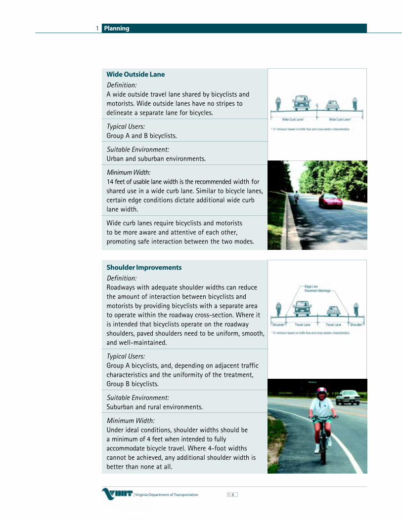
Wide Outside Lane
Definition:A wide outside travel lane shared by bicyclists andmotorists. Wide outside lanes have no stripes todelineate a separate lane for bicycles.
Typical Users:Group A and B bicyclists.
Suitable Environment:Urban and suburban environments.
Minimum Width:14 feet of usable lane width is the recommended width forshared use in a wide curb lane. Similar to bicycle lanes,certain edge conditions dictate additional wide curblane width.
Wide curb lanes require bicyclists and motoriststo be more aware and attentive of each other,promoting safe interaction between the two modes.
Shoulder Improvements
Definition:Roadways with adequate shoulder widths can reducethe amount of interaction between bicyclists andmotorists by providing bicyclists with a separate areato operate within the roadway cross-section. Where itis intended that bicyclists operate on the roadwayshoulders, paved shoulders need to be uniform, smooth,and well-maintained.
Typical Users:Group A bicyclists, and, depending on adjacent trafficcharacteristics and the uniformity of the treatment,Group B bicyclists.
Suitable Environment:Suburban and rural environments.
Minimum Width:Under ideal conditions, shoulder widths should bea minimum of 4 feet when intended to fullyaccommodate bicycle travel. Where 4-foot widthscannot be achieved, any additional shoulder width isbetter than none at all.

Planning 1
| Virginia Department of Transportation 91-
✔
✔
✔
Ancillary FacilitiesAncillary facilities are the supporting facilities thathelp contribute to the success of a bicycle network.These facilities can include secure bicycle parking,bicycle lockers, and even shower and lockerfacilities in the workplace. Facility andinfrastructure needs do not stop with arrival at thework site or other destination. Many bicyclists arediscouraged from becoming bicycle commuters
because once at work they have no place to park their bicycle securely or to showerand change. Shower and locker room facilities should be encouraged and arebecoming more common place in office and commercial space.
Secure bicycle parking deserves special attention. Theavailability of parking is a prerequisite for automobile use;the same holds true for bicycling. Bicyclists also face possibletheft of or vandalism to their bicycles. Even when parkedsecurely, bicycles are frequently exposed to damage from rainand other environmental conditions. Parking facilities canvary from the simple U-Rack to a separate parking areadesignated for the exclusive use of bicycles. Secure bicycleparking is necessary before bicycle use will increase.
These facilities not only encourage employees to commuteby bicycle and be more physically active, they can also beconsidered an important element of a comprehensiveTransportation Demand Management (TDM) Plan bypotentially reducing peak period traffic congestion. Throughthis reduction in traffic congestion, air quality benefits canalso be obtained.
Understanding Bicycle FacilitiesEnvironment User Groups
Urban Group A — Advanced BicyclistsSuburban Group B — Basic BicyclistsRural Group C — Children Bicyclists
Facility Types Ancillary FacilitiesShared Use Path Bicycle RacksBike Lane Bicycle LockersWide Outside Lane Shower FacilitiesShoulder Improvements Water Fountains
Rest AreasBenches
✔
✔
✔
✔
✔
✔
✔
B E S T P R A C T I C E S 2
✔
✔
✔
✔
✔
✔
The U-Rack
B E S T P R A C T I C E S 1

Planning1
10| Virginia Department of Transportation 1-
Developing a Bicycle Plan
The bicycle planning process can be divided into seven steps. The remainder of thischapter provides a description of each of these steps.
At the beginning of the planning process, the appropriate staff members within thelocality should be assigned to the plan development and their role clearly identified:are they lead role, support role, or main point of contact. Depending on the locality,the responsibility for plan development may reside with the planning director, transportationstaff, engineering staff, public works director, parks and recreation director, or acombination thereof. Regardless, members from each department should participate atsome level to ensure that the plan addresses the multitude of issues that arise.
Define Public Involvement ProcessA vital component of the bicycle planning process is publicinvolvement. Public involvement occurs throughout theplanning process. To be truly effective, the process shouldinclude representatives from all of the relevant stakeholdergroups. The nucleus of the public outreach process shouldconsist of a strong Bicycle Advisory Committee supplementedby ongoing coordination with the general public, otherstakeholders, and elected officials. The following brieflydescribes this process.
Bicycle Advisory Committee (BAC)
Early in the planning process, a Bicycle Advisory Committeeshould be established by the locality. This committee serves asthe nucleus of the planning process, providing guidance andinput to local planning, engineering, and/or recreation staffassigned the responsibility of developing the plan. It issuggested that the BAC be generally comprised ofrepresentatives from the local planning commission, citizens atlarge, transit operators where applicable, and the bicyclingcommunity.
The representative from the planning commission or planningdepartment serves two important roles by bringing both anunderstanding of local government and planning experienceto the committee. The citizen representatives should be
selected in such a way that a broad range of community interests are represented. Thisis an ideal opportunity to actively engage minority and low-income sectors of thecommunity in accordance with Executive Order 12898, Federal Actions to AddressEnvironmental Justice in Minority and Low-Income Populations. Similarly, it isimportant to consider that the bicycling community is a diverse group and it would beuseful to invite a mix of bicyclists with different backgrounds as to age and bicycling
Seven Step Planning Process

Planning 1
| Virginia Department of Transportation 111-
interests. Throughout the planning process, the committeemust remain cognizant of the fact that its actions andrecommendations are meant to reflect the needs of the entirecommunity.
Prior to the appointment of an advisory committee, a charge andoutline of expectations should be prepared. This outline mayinclude a description of the purpose of the committee; adescription and requirements of membership, appointment, terms ofmembers, and methods to fill vacancies; a description of thepowers and duties of the committee; and recommended meetingschedule. While the above provides a good example, plannersneed to adapt the committee to their own local area and needs.
Coordination with Elected Officials
Some communities may also find it valuable to have a member of the localgoverning body (board of supervisors, city and town councils, etc.) serve on theBAC to act as an official liaison to the body. Such a representative can also keepthe local governing body informed of what the Bicycle Advisory Committee is doingand bring the reality of necessary political considerations to the committee. If no suchmember is on the BAC, periodic briefings on the plan’s development should be made tothe local governing body prior to the plan being presented for adoption. This will helpbuild local and political support for the plan before the adoption process begins.
Public Workshops and Meetings
In addition to the direct involvement of a Bicycle AdvisoryCommittee, opportunities should be made for other membersof the public to review and comment upon the proposedplan. Special efforts should be made to contact and involvegroups with a potential interest such as school boards,bicycle clubs, citizens in economically deprived areas, thelocal traffic safety commission, the business community,neighborhood civic associations, and directly affectedproperty owners. Public meetings should be widelyadvertised through local newspapers, cable television,government bulletins, or other media accessible to thegeneral public.
The general public and various public and private agencies can be involved at variouspoints in the process to provide input. At least one public meeting should be held earlyin the plan preparation process to increase understanding and support for the plan andseek public input. For example, an open public workshop or charrette could beorganized relatively early in the process to:
❚ Local Staff ❚ Stakeholder Groups❚ Elected Officials (schools, health, recreation)❚ Business Community ❚ Citizens at Large
❚ Advocacy Groups
Typical BAC Representation
Starting the Process

Planning1
12| Virginia Department of Transportation 1-
❚ define what a bicycle plan is
❚ brainstorm goals and objectives for the plan
❚ identify important attractions, connections, and corridors that could be part of thebicycle network
❚ offer input on the overall plan process
Subsequent workshops should be held to solicit input on a draft plan.
Public Involvement Process ChecklistDevelop outline of expectations and operations of a Bicycle Advisory Committee (BAC)Invite potential BAC members and obtain commitment to participateConduct an open public workshop or charrette in order to brainstorm goals andobjectives and to identify important attractions, connections, and corridors that shouldbe a priority in the bicycle networkLocal staff and BAC develop draft goals and objectives of the plan for submission tolocal officials and decision makersHold additional public workshops or charrettes as needed to address specific topicsimportant to the communityLocal staff and BAC develop draft plan and present to local officials and decision makersHold public information meeting to solicit input on draft planFinalize the plan based on input from elected officials and the publicSubmit the plan to local board of supervisors or city and town councils for formal adoption
The local staff and BAC would continue the planning process with regularly scheduledworkshops; the staff would carry out the work with input from the BAC. Representativesfrom various departments or agencies could be invited to particular workshops of theBAC in order to provide additional input. The following participants could be considered:
❚ Planning District Commission to understand the regional significance of a local planand its role in a regional plan
❚ Public Works Department to help develop a maintenance program for shareduse paths and bike lanes
❚ community leaders to address environmental justice issues and gain anunderstanding of the varying bicycle needs of diverse communities
❚ Virginia Department of Transportation to discuss upcoming constructionprojects that may complement the community’s bike plan
❚ Department of Health, local hospital representatives, and the police departmentto help develop a bicycle safety plan targeting children
❚ Department of Education to help devise programs for the inclusion of bicycleeducation into the school curriculum
✔
✔
✔
✔
✔
✔
✔
✔
✔

Planning 1
| Virginia Department of Transportation 131-
It should be noted that these are simply guidelines for a public outreach process. Somecommunities may only need limited involvement of the general public, whereas somemay require significant involvement.
Set Goals and ObjectivesIn terms of technical work, the first step in the planning process is to set the goals andobjectives of the bicycle plan. Goals and objectives complement one another and serveas the “blueprint” for the plan to follow. The goals and objectives can be drafted bylocal staff in conjunction with the Bicycle Advisory Committee or can be the productof a workshop or charrette open to the general public.
Goals and objectives need to be clearly defined, yet remain somewhat flexible to meetunforeseen challenges and needs in the future. Defining goals and objectives can sometimes beconfusing. A goal is a vision or an ideal future condition to which a community aspires.An objective is an intermediate step towards attaining a goal and is more tangible andspecific. Objectives represent concrete measurable actions in support of the overall goal.
Example Goal:
Foster a healthy community by supporting and encouraging bicycling as a viable modeof transportation through infrastructure improvements, intermodal connectivity, andeducation and enforcement programs.
Examples of Objectives:
Develop a comprehensive bicycle network by providing linear connections to keyattractionsConstruct 5 miles of shared-use path to encourage bicycling in the communityEncourage partnerships of public and private agencies through a defined publicoutreach processConstruct 10 miles of bicycle lanes in areas of significant bicycle demandReduce bicycle/motor vehicle crashesEnsure all children in the community have access to a bicycle helmetHeighten awareness of bicycling activities and benefits through publicity, includingattractive brochures and maps to inform citizens and to encourage their support inimplementing the bicycle facilities planEncourage private developers to include bicycle facilities in new construction projects
Establish Performance MeasuresPerformance measures need to be established during the initial stages of plandevelopment. Performance measures help define important qualitative and quantitativevariables to be considered in determining the desirability and effectiveness of a bicyclefacility. These variables need to be discussed and generally agreed to by local staff,public officials, and interested citizens to ensure synergy throughout the planningprocess. Some of the key variables are described on the following pages.
✔
✔
✔
✔
✔
✔
✔
✔

Planning1
14| Virginia Department of Transportation 1-
Accessibility
Readily accessible connections need to be considered a key component of any bicyclenetwork. Accessibility is measured by the distance a bike facility is located from aspecified attraction, the ease by which this distance can be traveled by bicycle, and theextent to which all likely origins and destinations are served. For example, someprogressive communities in other states have adopted a criterion of having a bicyclefacility within one mile of every residence.
Directness
Bicyclists and motorists both desire a direct and quick route to destination points.Studies have shown that most bicyclists will not even use the best bicycle facilityif it greatly increases the travel distance or trip time over that provided by lessdesirable alternatives. Generally speaking, Group A bicyclists prefer directness whileGroup B/C bicyclists prefer comfort and perceived safety as the key characteristics ofthe bicycle facility.
Continuity
A proposed bicycle network should be viewed as a transportation system and providecontinuous, direct connections to numerous attractions throughout the community. Ifgaps exist in the network, measures should be taken to provide safe and efficientshort-term alternatives and long-term permanent solutions.
Consistency
Providing consistent bicycle facility types should be a goal when planning anddesigning bicycle networks. To the extent possible, bicycle facilities should providebicyclists with a relatively consistent facility type (i.e. shared use path, bicycle lane,shoulder improvement) within key corridors. Switching between facility types cancreate conflict points, be confusing, and leave bicyclists with a sense of abandonmentwithin the overall network.
Route Attractiveness
Bicycle networks or portions of the network should encompass such factors asseparation from motor traffic, proximity of visual aesthetics, connections toemployment centers, major passive and active recreation areas, and the real orperceived threat to personal safety along the facility. These factors tend to encouragenovice and recreational bicyclists to view the bicycle as a mode of transportation andenhance the overall bicycle network.
Low Conflict
Bicycle networks should consist of routes that minimize conflicts between bicyclistsand motorists and between bicyclists and pedestrians. In addition, areas of high crashincidents should be avoided or addressed directly through intersection improvementsand/or other safety improvement measures.
BEST PRACTICES 3

Planning 1
| Virginia Department of Transportation 151-
✔
✔
✔
✔
Ease of Implementation/ Costs
Right-of-way, environmental, historical, and funding constraints, as well as thepolitical climate, must all be considered during the planning process to ensure thatimplementation of the plan is actually feasible. For example, land acquisition costsand historical and environmental impacts need to be carefully considered to determinethe feasibility of a project.
Multimodal Coordination
The integration of bicycling with other modes of transportation, particularly publictransit, benefits the entire transportation network. It has been well demonstrated inmany United States, European, and Asian communities that with the proper facilitiesand policies, bicycles can have a significant complementary effect on transit systems,resulting in increased ridership. Bicycles provide the on-demand, door stop service thatmost bus and rail systems are unable to provide. Buses and trains will usually travelfaster and farther than most bicyclists. The combination has a synergistic effectamplifying the market area and effectiveness of each. Park and ride facilities alsocomplement bicycle facilities by providing bicyclists and motorists with mode transferopportunities. Finally, multimodal connections help reduce traffic congestion byproviding alternatives to the single occupant vehicle (SOV).
Multi-jurisdictional Coordination
Providing and anticipating connections across jurisdictional boundaries are necessaryin developing a comprehensive plan. Communities need to look outside their bordersto ensure there is a level of regional connectivity associated with the local plan. Theregional Planning District Commission or Metropolitan Planning Organization canprovide insight and assistance during this process.
Safety and Security of Bicyclists
The design of bicycle facilities needs to be treated as any other transportation project,with personal and traffic safety as key design elements. Safety is an important part ofany plan and includes education, enforcement, encouragement, and design of facilities.The concepts of safety, such as safe intersection treatments, must guide the developmentof all bicycle facilities. In addition, the bicyclist needs to be educated about safebicycling practices. Finally, personal security issues need to be addressed, especially whendealing with shared use paths. Appropriate landscaping, lighting, safety call boxes,and frequent patrols are common measures to improve bicycling safety and security.
Performance Measures Checklist
Accessibility Ease of Implementation/CostsDirectness Multimodal CoordinationContinuity Multi-jurisdictional CoordinationRoute Attractiveness Safety and Security of BicyclistsLow Conflict
✔
✔
✔
✔
✔
BEST PRACTICES 4
BEST PRACTICES 5

Planning1
16| Virginia Department of Transportation 1-
Develop Local NetworkThe development of the local and regional network represents the heart of the planningprocess. It is divided into several intermediate steps as follows, each of which will bedescribed in greater detail below:
❚ inventorying existing systems
❚ identifying land opportunities and constraints
❚ identifying and selecting potential corridors
❚ selecting specific routes and facility types
❚ evaluating the overall bicycle network
The inventory of existing conditions and identification of potential corridors andconstraints can occur at the same time. The information from these steps is thencombined in order to select and evaluate potential routes for the bicycle network. Thefinal step is an evaluation of the overall bicycle network based upon generalperformance measures established earlier in the planning process.
Maps of the locality are central to developing a bicycle plan and can illustrate acomprehensive network of bicycle facilities connecting key attractions throughout thecommunity. Various types of base mapping can be used ranging from a local streetatlas to USGS quadrangle maps to a fully integrated geographical information system(GIS) database. The primary features needed on the base mapping include significantattractions (schools, neighborhoods, parks, employment centers, etc.), the existing roadsystem, physical barriers (rivers, active rail lines, etc.), and potential land corridors(abandoned rail lines, canal systems, utility lines, etc.).
Anytown, VA (see next page) was developed to help visualize the planning process fora bicycle network. Keeping Anytown in mind while reviewing the following sectionswill help illustrate the planning process.
Inventorying Existing Conditions
A crucial step in the planning process is to examine the existing transportation systemand major origin and destination points within the locality. The examination shouldinclude a review of the significant activity centers, existing bicycle facilities, existingroadway system, and planned roadway improvements.
Significant Activity Centers
Activity centers are locations where a significant number of bicycle trips start or maypotentially start (origins) and locations that may draw a significant number ofbicyclists (destinations). Local staff, the Bicycle Advisory Committee, local bicyclingadvocates, as well as the general public, can help identify these points of origin anddestination. Examples of key attractions include:

Planning 1
| Virginia Department of Transportation 171-
INTERSTATE
INTERSTATE
95
95
55
55
60
60
611
611
High CrashLocation
PlantationOffice Park
PlantationCommunityCollege
WashingtonRegional Mall
IntermodalCenter
SeniorCenter
HighSchool
SkylineRecreationCenter
RiversideCommunity
MissingRailroadTrestle
Running RiverState Park
FutureDevelopmentSite
Running River
Blue RidgeReservoir
Anytown Railroad
Aban
done
d Ra
ilroa
d
Main Street
Center Street
Middle Turnpike
Middle Turnpike
TownGreen
TownHall
PostOffice
Library
Garden Street
chec
kin\30
936\r
esou
rce g
uide
\conc
ept2
.dwg
Running River Bike Trail Rail
Trai
l
Simmers
Lantz
Anytown, VA
Plantation CommunityCollege
Plantation Office Park
Washington RegionalMall
Intermodal Center
Simmers Senior Center
Lantz High School
Skyline Recreation Center
Central Business District
Future Development Site
Riverside Community
Running River Bike Trail
Arterial Roads
Collector Roads
Local Roads
Residential Roads
Transit Corridors
PlannedTransportationImprovements
Abandoned Railroad
Running River
Anytown Railroad
I-95 Right-of-Way
Running River StatePark
Skyline RecreationCenter
Future DevelopmentSite
PlantationCommunity College
Plantation Office Park
Anytown, VA Inventory
I-95 Corridor
Anytown Railroad
Running River
I-95/Route 60 RampSystem
High Crash Location
Missing trestle
❚
❚
❚
❚
❚
❚
❚
❚
❚
❚
❚
❚
❚
❚
❚
❚
❚
❚
❚
❚
❚
❚
❚
❚
❚
Land OpportunitiesPotential ConstraintsTransportation NetworkActivity Centers

Planning1
18| Virginia Department of Transportation 1-
BEST PRACTICES 6
❚ residential areas — neighborhoods, especially those with large populations ofchildren and college students who will make up the majority of utilitarianbicycle trips
❚ schools, community colleges, and universities — bicycles are a common mode oftransportation for many elementary, middle, and high school students, as well ascollege and university students
❚ commercial centers — shopping centers, malls and plazas, downtown areas, andother commercial locations are common trip destinations
❚ employment areas — even if there are not currently a large number of bicyclecommuters, large employment areas and industrial parks for both white collar and bluecollar working areas should be included as destinations to encourage bicycle commuting
❚ public facilities — parks, libraries, museums, municipal buildings, and other publicservice facilities
❚ modal transfer stations — bus stops, commuter parking lots, and rail stations thatmay serve as trip destinations for the commuting bicyclist
❚ regional attractions — places outside of the jurisdiction, but within five miles
❚ unique features — historic, natural, and scenic points in the community forconsideration as present or future bicycle trip generators.
When identifying these attractions, it is important to keep in mind special subsets ofthe population that may depend upon the bicycle as a means of transportation. Forexample, in suburban environments teenagers and children may be especiallydependent upon bicycles to bridge the distance between their homes and populardestinations such as school, parks, or friends’ homes. Seniors may rely on bicycling,walking, and connections to transit as primary means of personal transportation to getto shopping areas, community centers, and other key destinations. Special care andconsideration should be taken to include these population subsets in identifying keyattractions and ensuring they are well served by a potential bicycle network.
Existing Bicycle Facilities
The location, condition, and level of use of existing bicycle facilities should berecorded. It is important to reiterate that the term bicycle facilities is meant to include

Planning 1
| Virginia Department of Transportation 191-
INTERSTATE
INTERSTATE
95
95
55
55
60
60
611
611
bikeways such as lanes, routes, shared use paths, shared roadways, as well as parkingfacilities such as bicycle parking racks, areas, lockers, and secured fenced areas such asmay be found at some schools.
Existing bikeway facilities may already be properly designed or designated to providesome of the connections desired by the community. For instance, both InterstateBicycle Routes 1 and 76 cross Virginia. Other existing facilities may simply require minorimprovements, an extension, or spur. Similarly, the existence of heavily used bicycleparking facilities may help to identify favorable routes and attractions. In any case,the locality’s existing bicycle facilities should not be overlooked as a foundation uponwhich a comprehensive bicycle network can be built.
As a final note, identifying destinations that are “bicycle friendly” is important. Anexample is an employment center that currently encourages bicycle commuting byproviding showers, locker rooms, bicycle parking, or any other incentive programs.
Existing Roadway System
The existing roadway system in most localities will provide general connections tothe majority of the attractions highlighted. In order to assess the effectiveness andappropriate treatment of a potential bicycle route within a roadway corridor, certaintraffic flow and roadway geometric characteristics need to be identified. For example,a high-speed, congested highway with limited right-of-way and numerous curb-cutswould not be appropriate for Group B/C bicyclists, and might be discounted as apotential bicycle route.
Traffic flow and roadway geometric characteristics can typically be obtained fromlocal planning and engineering staff or from VDOT. The Transportation PlanningDivision of VDOT maintains a comprehensive database of roadway characteristicsavailable to localities.
Planned Roadway Improvements
A variety of planning tools can be consulted to identify planned roadwayimprovements in a given locality, including:
❚ Virginia Transportation Development Plan
❚ regional transportation plans developed by the Metropolitan Planning Organizationor the Planning District Commission
❚ local comprehensive plan
❚ capital improvement plan
Planned roadway improvements can be an important element of an overall bicyclenetwork. These improvements may be ready for immediate implementation withfunding mechanisms in place. In some cases, minor enhancements to planned highwayor street improvements can significantly improve bicycle accommodation within aroadway corridor.
BEST PRACTICES 7
Anytown Roadways

Planning1
20| Virginia Department of Transportation 1-
✔
✔
✔
✔
✔
✔
✔
✔
✔
Minor Roadway Improvements
Minor shoulder wideningSpeed limit reductionsBicycle sensitive loop detectors at signalized intersections“Share the Road” signage as appropriate
Significant Roadway Improvements
A shared use path within the right-of-wayBike lanesFour-foot paved shouldersBicycle accommodation on bridges and through underpassesConnections to adjacent bicycle facilities and attractions
In some cases, major highway and street improvements could make a potential bicycleroute less desirable by introducing additional travel and turning lanes, center medians,increased travel speeds, and an increase in heavy vehicle traffic.
VDOT recognizes the importance of an adopted bicycle plan and strives to includebicycle facilities identified in the plan as part of new roadway construction orreconstruction. In fact, as part of its roadway design process, VDOT has incorporatedprocesses to address the need for bicycle facilities. Chapter 2: Design providesexamples of some of these programs and procedures in support of bicycling.
Identifying Land Opportunities and Constraints
Public and private land opportunities and constraints need to be identified and shouldalso be considered in the early stages of developing a potential bicycle network. Potentialconstraints when developing a bicycle network can include land barriers, environmentalimpacts, historical impacts, funding shortfalls, lack of public support, and politicalwill. The following section identifies some potential land opportunities and barriers.
Linear Rights-of-Way
Potential linear corridors with intact right-of-ways and/or consistent ownershipprovide an excellent opportunity for shared use paths that could be viewed as a spineor trunk line of a bicycle network. The following are some examples of corridors thatcould be used for this purpose:
❚ abandoned railroad corridors — abandoned railroad corridors often connecttown centers with local attractions and reflect historical attributes of thecommunity. In addition, railroad corridors are generally direct, consist of gentlegrades, and bridge and tunnel structures remain in place requiring minimalimprovements. “Rail-to-Trail” is typically used to describe these corridors whenconverted to a shared use path.
❚ active railroad corridors — land adjacent to active rail corridors can be consideredfor shared use paths if there is sufficient separation between the two uses. Speed and

Planning 1
| Virginia Department of Transportation 211-
frequency of the trains within the corridor need to be carefully considered duringthe design of these facilities. “Rail-with-trail” is typically used to describe an activerail corridor with a shared use path within the right-of-way. Extensive coordinationwith the railroad companies is necessary to determine the feasibility and necessarysafety measures to develop a rail-with-trail.
❚ highway rights-of-way — highway and roadway rights-of-way are commonly usedfor shared use paths because the roadway corridors already provide connections tomany attractions. Shared use paths adjacent to congested highways and roadwayscan also be considered as part of an incident management plan for emergencyvehicle access to the roadway network.
❚ utility corridors — utility corridors (water, electric, sewer, etc.) can provide arelatively unobstructed corridor for the development of shared use paths. Inaddition, utility companies sometimes welcome the development because it not onlyprovides a community benefit, it also improves access to the utilities for routinemaintenance and emergency service.
❚ canal tow paths — similar to railroads, canal tow paths many times connect towncenters with local attractions and reflect historical attributes of the community. Canaltow paths also provide gradual grades that can be easily converted to shared use paths.
❚ riverways — river corridors can provide an attractive location for bicyclefacilities due to the relatively low impact of bicycles on the river system and theattraction of nature and scenic vistas for the bicyclists. Development patterns alongsignificant rivers often vary in uses and provide for unique connections, such astown centers to recreational areas, residential areas, industrial areas, etc.
❚ oceanfronts — oceanfronts can provide an attractive location for bicycle facilitiesand provide increased access to beaches and other recreational activities along theshore. Shared use paths can be especially successful along oceanfronts whenconnecting hotels, restaurants, and other attractions.
Public and Private Lands
In many cases, the corridors mentioned above may not be available or exist within alocality. Localities have existing land uses that present opportunities for incorporationinto a local bicycle network. The table on the following page identifies some differentland uses that may be considered potential opportunities to help round out a bicyclenetwork by providing key connections or full bicycle facilities.
Public lands are often available for improvements that benefit the entire community,such as sidewalk and bicycle facilities. Private developers would also be interested inincorporating bicycle facilities into development plans if appropriate land use policyand zoning incentives were in place. A discussion on land use and zoning strategiessupporting bicycling activity is presented later in this chapter.

Planning1
22| Virginia Department of Transportation 1-
Public Lands Private Lands
Public parks and recreation areas Office parksAccessible wildlife refuges Commercial centersHigh, middle, and elementary schools Regional mallsUniversities and colleges Corporate campusesMunicipal buildings — libraries, town Residential developmentshalls, post offices, etc. Hospitals, continuum care centers
Senior centers
Barriers
Physical barriers, both man-made and natural, that hamper bicycle passage needto be identified and should also be considered in the early stages of developing abicycle network. Many of these barriers are within the same corridors that offerpotential opportunities for the development of bicycle facilities presented in theprevious section. Examples of major barriers include:
❚ the cross-section for an existing bridge over a major river may not have beendesigned to accommodate both bicycles and motor vehicles
❚ an active rail line may restrict opportunities to connect bicycle facilities on eitherside of the corridor
❚ overpasses, underpasses, and ramp systems of roadways intersecting majorhighways may reduce the cross-section of the roadway, creating a squeeze point forthe bicyclists. In addition, high speed weaves between motor vehicles and bicyclistscan be problematic at ramp systems
❚ motor vehicle high crash locations can compound safety issues for bicyclists
In addition to physical barriers, there may also be state or local regulatory barriers.For example, for intrinsic conflicts between high-speed traffic and bicycling andother safety issues, Virginia state law allows the Commonwealth TransportationBoard to prohibit bicycles, and other motorized and non-motorized activity, onselected controlled access highways, including interstates. If a potential travel corridorruns along an interstate, an alternate route would need to be identified. A list offacilities in Virginia on which bicycle use is prohibited is available from theState Bicycle/Pedestrian Coordinator.
The presence of a barrier does not necessarily preclude bicycle travel through apotential corridor. As particular routes are examined within the travel corridor,it may prove feasible to eliminate the barrier through actions such as the widening ofa bridge, other structural improvement, or a change in a local regulation.
✔
✔
✔
✔
✔
✔
✔
✔
✔
✔
✔
✔

Planning 1
| Virginia Department of Transportation 231-
BEST PRACTICES 8
Identifying Initial Corridors for Consideration
Identifying the corridors of existing and potential bicycle use based on current andanticipated attractions is the next step in the process. These corridors are thenevaluated and screened as part of the following steps in the development of the plan.
Connecting the Attractions
Once points of trip origination and destination are marked on the map, lines can bedrawn to connect them. These lines represent potential travel corridors or “desire lines”for bicyclists. Although drawn as lines, these corridors should be envisioned as broaddesire bands that are not necessarily limited to a particular existing roadway. Thisexercise will help define a preliminary framework for a system of desired bicycle routes.
In order to avoid a confusing and unrealistic “spider web” of lines, carefulconsideration must be given to various connections. For example, connecting aresidential area with a park is reasonable; whereas connecting a park with anindustrial park may not be a reasonable connection considering the overall goals andobjectives of the plan. It is also reasonable to screen out some of the potentialconnections based on previously established performance measures to minimize anovercomplicated network of potential bicycle facilities.
Selecting Specific Routes and Facility Types
The corridor identification process identified preferred lines for bicycle travel betweenvarious locations. The next step is the identification of specific routes within thesecorridors that can be designed or adapted to accommodate the anticipated user group.As a starting point, Group B/C users should be considered the “design vehicle.”3 Inaddition, the facility type (on-road accommodations or shared use paths) needs to beconsidered when evaluating an overall network.
The two general types of bicycle facilities can be classified as shared use paths (off-road)and on-road accommodations. While roads and shared use paths are both important tobicycle travel, roads are the key element because the road network is established, moreextensive, and already provides access to most attractions. The following descriptionhighlights key parameters that need to be considered when reviewing and evaluatingshared use paths and on-road accommodations as part of a bicycle network.
❚ Shared Use Paths (Off-road Facilities)
Shared use paths are facilities on continuous right-of-way that serve all bicycle usergroups, as well as a variety of other users including walkers and roller skaters. Thesefacilities are typically a minimum of ten feet wide, with appropriate shouldertreatments, to allow for safe passing and multiple user types. They can be used forshort connections, such as a neighborhood to a school, or as a key corridor spinethrough an entire community, such as an abandoned railroad line providing a seriesof connections to key attractions and other bicycle facilities.
3 As discussed earlier, Group A bicyclists in many cases are best served by adopting highway design standards to make every streetas “bicycle-friendly” as possible. This approach is discussed more thoroughly in the Chapter 2: Design.
BEST PRACTICES 9

Planning1
24| Virginia Department of Transportation 1-
4 Guide for the Development of Bicycle Facilities, AASHTO, 1999.
Availability of public right-of-way is often a key factor when considering shared usepaths. Unless adequate right-of-way is available, shared use paths can require morefunding and land coordination than on-road accommodations. In addition, thesefacilities can be controversial because of perceived safety and security impacts toadjacent property owners. Shared use paths can be considered as a catalyst forintroducing communities to bicycling as a viable mode of transportation and a formof recreation. Shared use paths also boast many non-measurable benefits such as asense of community pride, a place for physical fitness, and tourism and economicbenefits. Many communities throughout Virginia are currently experiencing suchbenefits from these facilities.
As with any other transportation corridor, shared use path facilities need to beappropriately planned and designed to ensure user safety. Design guidelines havebeen developed by AASHTO4 to help planners and engineers apply appropriatedesign criteria for the variety of users and uses of these facilities. Specificinformation on the design of these facilities is presented in Chapter 2: Design.
❚ On-road Facilities
The existing roadway system offers a variety of opportunities for bicycle travel andprovides many of the connections to key attractions needed to support a successfulbicycle network. Roadway characteristics that affect bicycle travel need to becarefully considered when identifying on-road bicycle routes. Traffic flow androadway geometrics are the two characteristics that affect bicycle travel the most.These characteristics can be further broken down into the following variables: trafficvolumes, travel speeds, outside-lane width, and percentage of heavy vehicles. Thesevariables need to be considered collectively when identifying and evaluating aroadway as a potential bicycle route. The following describe these variables:
❚ traffic volumes — the amount of motor vehicle traffic a bicyclist is exposed toduring a trip can considerably impact the trip experience. Higher motor vehicletraffic substantially increases potential conflicts between bicyclists and motorvehicles. As traffic volumes approach a roadway’s capacity, these conflicts increase.
❚ travel speeds — wind turbulence caused by high motor vehicle speeds can causebicyclists traveling within the roadway to become unstable and lose control. Thiswind turbulence is referred to as “truck blast” and significantly increases withheavy motor vehicles (i.e. trucks, buses, and RVs) traveling at higher speeds. Inaddition to high travel speeds, wide variations in posted speed limits within aroadway corridor can mislead a bicyclist’s expectations of the corridor.
❚ outside-lane width — the overall cross-section of a roadway corridor is one of themost important variables in evaluating a roadway as a potential bicycle route. The totalwidth of the outside travel lane and the adjacent usable shoulder dictates the availableoperating space for the bicyclist and motorist. This width is referred to as the outside-lane width and should not include gravel or unpaved shoulders or gutter pans.

Planning 1
| Virginia Department of Transportation 251-
✔
✔
✔
✔
✔
✔
✔
✔
✔
✔
✔
✔
✔
✔
✔
✔
✔
✔
✔
✔
✔
The adjacent tablepresents the typicalparameters affectingpotential bicycleaccommodation. Thewidth of the roadwayand traffic flowcharacteristics tend tobe the most critical,with “other” factorscontributing to thecomfort of thebicyclists.
❚ heavy vehicles — trucks and other heavy vehicle traffic, such as buses, within theoutside travel lane affect bicyclists’ safety and comfort as a result of “truck blast,”aggressive inside wheel tracking, and blind spots in the operator’s field of vision.In addition, buses and trucks generally require additional width within a lane.Roadways with high truck volumes should be avoided as preferred routes.
Parameters Affecting Potential Bicycle AccommodationPhysical Traffic Flow Other Factors
Total roadway width Traffic volumes Curb cutsOutside lane width Traffic speeds Intersection spacing
Heavy vehicles On-street parkingSight distance restrictionsGradeEnvironmental featuresBarrier curbingRumble stripsPavement condition
Many localities complete this element of the route assessment from a qualitative,more intuitive perspective, working with local bicycle clubs and relying on thegeneral “feel” of a roadway. In contrast to the intuitive approach, analysis toolshave been developed to help assess the “suitability” or “level-of-service” ofroadways to accommodate bicycle travel based on the parameters presented above.These analysis tools can be based on an existing regional or local transportationmodel or be developed as an independent model. In many cases, an existinggeographic information database can form the baseline for creating such a model.These tools can be helpful in selecting preferred on-road bicycle routes and canassist in identifying structural and non-structural improvements that may improvebicycle accommodation for specific roadways. Some of these structural andnon-structural improvements may include:
Improvements to Better Accommodate Bicyclists
Shoulder improvements Minor roadway wideningsAccess management (curb-cut Speed limit reduction and uniformityconsolidation) Heavy vehicle restrictionsRelocation of on-street parking Sight distance improvements
In addition, VDOT has identified guidelines within the Road Design Manual thatindicate appropriate design treatments based on operating speeds, average annualdaily traffic volumes, heavy vehicles, and sight distance. This information ispresented in Chapter 2: Design and can be used to identify general thresholds forthe variables affecting bicycle travel described in this section.

Planning1
26| Virginia Department of Transportation 1-
Demand Forecasting
It is important to note that the resulting map may not be a representation of wherebicyclists are, but instead is a reflection of where bicyclists wish to go. Understandingboth existing and projected demands is helpful in the evaluation and prioritization ofbicycle facilities being considered. The actual travel patterns of bicyclists (especiallythe non-commuter) are heavily influenced by their perception of safety and personalsecurity. Uncomfortable or threatening bicycling conditions, as well as personal safetyissues, may cause bicyclists to choose or alternate their route from their preferred one,to choose a different travel mode, or not to make the trip at all. Thus, the task of thebicycle planner is to ask:
❚ “Where are the bicyclists now?”
❚ “Where would they be if they could go where they preferred?”
❚ “What are the impediments preventing them from going where they prefer?”
Although the use of existing traffic flows is a useful overall predictor of bicyclistpreferred routes, key attractions are still the best indicators of where bicyclists want tobe. A few common examples to illustrate this thought process follow:
❚ schools, especially colleges and universities, and military bases can generate a largeshare of bicycle trips. This is especially true for campuses where motor vehicleparking is limited
❚ parks, beaches, libraries, greenways, rivers and lakesides, scenic roads, and otherrecreational facilities attract a proportionately higher percentage of bicycle trips
❚ significant barriers such as limited access highways and rivers with a limitednumber of bridges can “force” use of certain routes over, perhaps, more desiredconnections
Most localities address this element of the plan from a qualitative perspective. Thisapproach is certainly acceptable. There are also transportation models that have beenadapted to forecast potential bicycle use based on demographic information, trafficinformation, development patterns, and key origins and destinations (attractions). Inconcert with local knowledge, these tools can be helpful in establishing preferredbicycle routes throughout a locality.
Evaluating the Overall Bicycle Network
Within a corridor there may be several potential routes that could serve the purpose ofconnecting key attractions. These routes should be evaluated based on theperformance measures previously discussed, especially the ability to serve the targeteduser group and the ease of implementation of the proposed facility. Ease ofimplementation of a facility evaluates order of magnitude costs, impacts to sensitivenatural or cultural features, local support, available funding, political climate, etc.
BEST PRACTICES 10

Planning 1
| Virginia Department of Transportation 271-
Typically, selecting specific routes andfacility types is a highly interactive process.The practicality of adopting a particularroute to accommodate Group B/C bicyclistsmay vary widely depending upon the typeof facility selected. For example, a lessdirect route may become the best option ifcomparatively few, inexpensive, and easilyimplemented design improvements arerequired.
This step should be approached as aninteractive process in which both routeselection and facility type are consideredtogether to achieve a network that is highlyadvantageous to the user, is affordable, hasfew negative impacts on neighbors andother nonusers, and can be readilyimplemented.
The team needs to evaluate the proposed network plan using the establishedperformance criteria. The proposed network should meet the design and performancecriteria established at the start of the planning process. If it does not meet most ofthese criteria or inadequately meets a few critical goals, either the proposal will requirefurther work or the performance measures must be modified. In the latter case,previously discarded routes should be reconsidered. These routes may now be morepreferred options in light of the newly modified performance measures. This realitycheck is important. Many well-considered proposals flounder when it is determinedthat the finished project no longer meets established goals and objectives for the plan.
Identify Potential Support ProgramsIt is important to recognize that planning for physical facilities is only part of thebicycle planning process. In order to achieve a successful bicycle transportationsystem, additional support programs are necessary. These programs can be groupedinto three categories that are often called the three E’s of bicycle planning: education,encouragement, and enforcement. A brief description of the three E’s is providedbelow. A more detailed treatment of these aspects of a comprehensive bicycle programis provided in Chapter 3: Three E’s.

Planning1
28| Virginia Department of Transportation 1-
Education
Comprehensive public information and education programs are needed to raise thecommunity awareness of the need for and ways to improve both bicyclists’ ridingskills and community culture or attitude toward bicyclists. Part of the planningprocess should enlist the support of schools, civic associations, bike shops, clubs(i.e. boy scouts, girl scouts, etc.), local police departments, and others to help in theeducation of the general public on the benefits of bicycling.
Encouragement
Although the bicycle has become common place in many homes and bicycling isone of the nation’s most popular recreational activities, few adults regularly bicyclefor transportation purposes. While a lack of facilities and land use planning canmake certain trips quite difficult by bicycle, most people are capable of usingbicycles for at least some of their trips. Getting people to bicycle more oftenrequires not only education, but also, encouragement and special incentives.
Enforcement
Bicycles ridden on public roads in Virginia are classified as vehicles and arerequired to obey all traffic rules just like motor vehicles. Similarly, motor vehicleoperators have certain responsibilities in respect to bicycles on the roadways.Enforcement programs complement educational programs in ensuring the safetyof all users of the transportation system.
Land Use and Zoning Policies
Current land use and zoning policies need to be reviewed for consistency withestablished goals and objectives of the bicycle plan. The relationship between land useand zoning is important because land use patterns influence transportation choices.Updates of land use and zoning policies and practices can create many opportunitiesfor considering bicycle travel as a viable transportation choice. These policies andpractices typically guide all development through statewide regulations and local landuse controls and can be effective mechanisms to improve bicycling conditions. Thefollowing typical regulatory activities should reflect strong support in order for abicycle plan to realize its full potential.
Master Plans
The effectiveness of land use planning as an approach to promote bicycle use restspartly on how much a locality is willing to focus on increased bicycle use as a statedcommunity goal. The most direct way for a locality to address such a goal is toclearly state it in the context of a master plan or comprehensive plan. This can bedone within a master plan, through a specific objective, a stand-alone section of theplan, and/or be woven throughout the entire plan.

Planning 1
| Virginia Department of Transportation 291-
A reasonably current master plan generally provides a locality with ample opportunityto state policies aimed at bicycle use, and, more importantly, to convert these policiesinto law through local government. In addition, it is important to ensure local bicycleplans/guidelines are clearly stated in master plans in such a manner that their impactson development decisions are clearly understood. The goal should be to informproject proponents, at the earliest practical point, of the importance of bicyclefacilities, ancillary bicycle facilities, and supporting programs in local land usedecisions. Practical incentives fostering creative compliance or participation by theprivate sector should also be encouraged.
Long Range Transportation Plans
Long Range Transportation Plans (LRTP) are required to address walking and bicycling.According to Title 23 — United States Code, both metropolitan and statewide planningefforts must address pedestrian walkways and bicycle transportation facilities as anintegral part of an intermodal transportation system for the state and United States.LRTP’s also offer an additional opportunity to incorporate a locality’s willingness andinterest in bicycle travel at the regional level. The Metropolitan PlanningOrganizations address existing and anticipated transportation needs within the region,including bicycle travel, as part of the LRTP. This planning activity allows for theidentification, coordination, and prioritization of localized and multi-jurisdictionalbicycle facilities. Through this process localities are encouraged to reach outside theirjurisdictional boundaries to ensure local bicycle plans reflect regional cohesiveness.Similarly, regional bicycle plans need to reflect the desires and intent of the local plans.
Zoning Bylaws and Ordinances
At the local level, zoning bylaws and ordinances can help stimulate bicycle facilitiesthrough a variety of mechanisms. The following present some examples:
❚ zoning requirements — in a simple requirement situation, a zoning bylaw coulddefine how many bicycle parking spaces would be required per 1,000 square feet ofspace (or other relevant measure, such as seats, beds, or classrooms). Theserequirements would have to be met before the regulatory body grants an occupancypermit. For example, both Gloucester and York Counties have developedrequirements for bicycle parking facilities within their parking ordinances.
❚ development guidelines — within the zoning process, design guidelines provide amechanism for a locality to discuss adjustments to a proposed development plan withthe developer. These discussions and negotiations generally occur when the developersubmits site plans for approval and/or requests a special permit. During this process thelocality can suggest and/or require measures to accommodate bicycle travel and use.
❚ subdivision regulations — subdivision regulations could include specificrequirements for inclusion of bicycle facilities depending on the size and density ofthe proposed development. These requirements could vary from inclusion of ashared use path through the development to bicycle lanes on proposed streets.

Planning1
30| Virginia Department of Transportation 1-
Develop Implementation StrategiesA plan is of little value unless steps are taken to ensure that the ideas contained in theplan will be translated into action. An implementation strategy serves this purpose by:
❚ identifying the organizations with responsibility for enacting the plan
❚ detailing the approximate costs for enacting the various projects in the plan
❚ identifying sources of funding for projects
❚ prioritizing projects
The objectives established for the plan must be reflected in the development of animplementation strategy to ensure the success of the plan. In addition, animplementation strategy should address maintenance issues for both existing facilitiesand new facilities resulting from the plan.
Priorities need to be developed for the implementation of the recommendations. TheBicycle Advisory Committee should be involved in developing criteria (i.e., preferredfacility types, target user groups, etc.) used to set priorities. To be most effective, thebicycle plan should include both short-term and long-term components.
The short term plan, developed as a list of priorities, must be carefully based on andcoordinated with available resources and may consist of such actions as physicalimprovements, changes in code and ordinances, changes in policy, educationalprograms, safety programs, and bicycle use promotion activities as well as a numberof other recommendations. The short-term plan must be designed in conjunction withcapital programming and coordinated with ongoing efforts that may impact identified actionitems. The short-term plan also needs to be an active, flexible plan that can respond to thechanging needs of the community.
The long-range plan should list potential sources of funds to carry out the physicalimprovements it proposes. While costs are factored into the evaluation of the planelements, there is no need to express dollar amounts in great detail because of thechanging nature of such projections. The plan must have flexibility to adapt to theavailability of funds. Including detailed projected costs simply assures that the planwill all too quickly become out of date or is too rigid to be broken down into smallerelements. It is better to leave the consideration of improvement programming to themore detailed short term planning efforts.
Create and Adopt Final Plan DocumentOnce the implementation strategy is complete, the final step is the actual creation andadoption of the plan document.
The importance of accurate and clear mapping in the plan cannot be overemphasized.Base mapping should include major roadways and landmarks that are clearly labeled.The different types of bicycling facilities should be coded on top of such a base map,preferably using a system of colors or line types to denote various bicycle facility

Planning 1
| Virginia Department of Transportation 311-
types. Depending on the extent of the proposed network, short-term and long-termpriority projects can either be identified on one map or displayed on separate maps.Supporting documentation demonstrating the process, including public outreach, routeselection, and plan adoption should also be included.
An adopted plan indicates community buy-in and political support, increasing thepotential success of the plan. In Virginia, bicycle plans can take various forms and arecommonly seen as:
❚ a stand-alone bicycle plan or bicycle and pedestrian plan
❚ a component of a transportation plan
❚ a component of a parks and recreation plan
❚ a component of a comprehensive plan
A locality’s governing body (board of supervisors, city council, or town council) canformally adopt the bicycle plan in any one of these forms or variations thereof. Forpurposes of considering funding, VDOT does not distinguish between the various typesof plans as long as the local governing body or an MPO adopts the plan.
While the bicycle plan can be adopted in various forms, it is recommended that theplan be adopted as a component of the locality’s comprehensive plan. A localcomprehensive plan is truly a locality’s “blueprint” for future development and landuse and zoning policies. Incorporating the local bike plan into the comprehensive planindicates that a locality is committed to bicycling. Specific requirements set by statelaw specify procedures for comprehensive plan adoption, amendment, and review.Appropriate adoption ensures the bicycle plan is tailored to meet the locality’sexpectations through the adoption of the comprehensive plan.
It is important to note that even when the plan is created and adopted by the localgoverning body, the planning process does not end. At this stage the plan becomes alive document, guiding the actions and decisions of the locality so that the goals
and objectives outlined in the plan are realized. The plan must beupdated periodically to keep it current to the needs of the community.While the short-term elements of the plan may be updated asfrequently as once a year as part of a capital programming plan,long-range elements may not need to be updated more then once everyfive years. Finally, consistent local support is critical in the success ofany adopted bicycle plan. This support provides the foundation forquick implementation and future development of the plan.
B E S T P R A C T I C E S 11

Bicycle Parking Facilities
BEST PRACTICES 1
P L A N N I N G
Bike Lockers
contact
Washington
Metropolitan Area
Transit Authority
600 Fifth Street, NW
Washington, DC 20001
www.wmata.com/metrorail/BIKRKS.HTM
Bicycle security is
one of the biggest
concerns expressed
by the bicycle
commuter or “would be” bicycle commuter.
The average cost of bicycles has significantly
increased, yet most bike locks can be
easily broken with the right tools. Taking
your bike into the office or locking it in a
common bike room are both popular
solutions. Bike lockers are becoming a
more common solution because of the
increased security and flexibility they
provide. Bike lockers benefit bicyclists by
providing a secure environment for their
bicycle and accessories, as well as protection
from inclement weather.
Many private and public organizations in
Virginia have taken initiatives to install
bike lockers. The U.S. Patent & Trademark
Office installed 10 bike lockers for its
employees in an unsecured parking
garage. VDOT installed bicycle lockers
adjacent to the W&OD Trail and a park
and ride lot in the City of Reston. The
lockers are still highly sought after and
sometimes require a waiting list. Along
the same lines, VDOT is in the process of
installing almost 100 bike lockers at eight
“Park & Ride” locations. The Washington
STATE WIDE
Metropolitan Area Transit Authority has
780 bike lockers at its Metrorail stations
and charges a yearly fee of $70.00.
Commuters are able to combine biking
and rapid transit to greatly expand the
opportunities for those who live too far
from the office to commute by bike. The
program has been very successful and well
received.
More people commuting by bike benefits
others by reducing congestion and freeing
up more parking space for cars. The
amount of space needed for bike lockers is
relatively small — 18 bicycle lockers
occupy the space of one car.

BEST PRACTICES 2
Bicycle Parking Facilities
P L A N N I N G
VDOT Northern Virginia Bike Rack Program(NOVARacks)
contact
VDOT
Northern Virginia District
3975 Fair Ridge Dr.
Fairfax, VA 22033
703.383.2231
Safe and secure
bicycle parking is
a critical issue
for those traveling
by bicycle. To
encourage bicycling
as a viable mode of
transportation, the VDOT Northern Virginia
District office is using $200,000 from
Congestion Management and Air Quality
(CMAQ) funds to purchase and install
1,000 bike racks in different communities.
The bike rack program was part of a
regional Transportation Emissions Reduction
Measure (TERM) adopted through the
Metro-Washington Council of Governments
(MWCOG) Transportation Planning Board.
Working with various communities in the
area, VDOT, local officials, and business
owners identified key locations where the
bike racks would be of most benefit to
encourage bicycling as an alternative mode
of transportation.
The racks chosen by VDOT were the inverted
U-shape, popular with bicyclists and localities
because they allow almost any style bike to
be locked securely, have low maintenance
needs, and are aesthetically pleasing. They
can be placed individually or in clusters as
needed, allowing a degree of flexibility.
Not surprisingly, the program has drawn
praise from area bicyclists. It not only has
provided nearly 1,000 needed new bike
racks; it also clearly shows VDOT’s intent to
help create a seamless mobility chain that
includes bicyclists and their special needs.

BEST PRACTICES 3
Local Comprehensive Planning
P L A N N I N G
Virginia Beach On-Road andOff-Road Facilities
contact
City of Virginia Beach
Department of Planning
Operations Building
Room 115
2405 Courthouse Drive
Virginia Beach, VA
23456-9019
757.427.8593
www.vbgov.com
The City of Virginia
Beach has made
great strides towards
accommodating
bicyclists whether they be residents of the
city or one of the many tourists that visit
the area each year. In fact, Virginia Beach’s
Boardwalk along the city’s renowned beach
has been recognized in national tourism
magazines as a premier urban bike trail.
Many tourists to the area take advantage
of the numerous bicycle rental shops to
make bicycling their preferred mode of
travel in and around Virginia Beach.
In addition to the Boardwalk, the city has
provided on-road and off-road facilities to
enable bicycle travel in other areas of the
city. For example, the city has developed a
bicycle facility network linking the many
hotels along the oceanfront with the
Virginia Marine Science Center and other
attractions. The city has also provided an
off-road facility for its bayside community
that provides access off the main road
both to shopping facilities and First
Landing State Park. Through the proper
planning of these facilities, bicycling has
become a regular activity throughout
Virginia Beach for tourists and residents
alike. A cornerstone of this planning effort
is the Virginia Beach Outdoors Plan
(VBOP). The plan forms the framework for
continued expansion of on-road and off-
road bicycle facilities, recreation facilities,
beach access, and preservation activities.

BEST PRACTICES 4
Bikes on Buses
P L A N N I N G
Charlottesville Transit Service:Bikes and Buses Sharing the Road
contact
Charlottesville Transit Service
P.O. Box 911
Charlottesville, VA 22902
804.970.3794
www.ci.charlottesville.va.us
Linking bicycles
and transit is a
win-win proposition.
Studies have shown
that most people
will consider
traveling by bike
for distances of
five miles or less.
Development patterns often require travel
distances much farther than five miles.
The combination of biking and taking the
bus can increase the utilization of these
two alternative modes of transportation by
expanding the market areas of these services.
Charlottesville began its Bikes on Buses
program in 1997. The City of Charlottesville
Transit Service (CTS) has outfitted all of its
buses, trolleys, and vans with bike racks.
The racks, attached to the front of each
bus, hold two bikes and are easy to use.
The rider simply flips the rack down,
places the bike in the rack, and gets on
the bus. It’s that simple! As part of an
interactive training program in support of
the Bikes on Buses program, CTS has
representatives from the local bicycle
advocacy group, CHABA, work with bus
drivers regarding a bicyclist’s needs. In
turn, bus drivers share their perspective of
effectively supporting bicycling throughout
the city.
Using grant money from the Virginia
Department of Rail and Public Transportation,
Charlottesville Transit Service has produced
a video documenting the success of the
Bikes on Buses program. “Bikes and Buses:
Sharing the Road” premiered in October
2000 and is available to the public. To
promote the use of alternative transportation,
CTS and the City of Charlottesville continue
to sponsor events, such as “Bike to Work
Day,” and plan to install bike lockers at key
bus stops to further support the connection
of these two modes.

BEST PRACTICES 5
P L A N N I N G
East Coast Greenway
contact
Barbara Nelson
Executive Director
Virginia Trails Association
P.O. Box 1132
Ashland, VA 23005
www.greenway.org
Virginia sits midway
along one of the
most ambitious
trail projects for
non-motorized
travelers in the
United States.
Designated as a “National Millennium
Trail,” the East Coast Greenway is being
developed along the eastern seaboard,
connecting cities from Maine to Florida.
It is envisioned as a multi-use and urban
compliment to the Appalachian Trail; the
greenway is a unique bicycle and pedestrian
facility, both off-road and on-road, that will
serve as a linear park and travel corridor through
our nation’s densest region. Beginning as
a vision ten years ago, it is becoming a
reality segment by
segment through
the efforts of
citizens at national,
regional, state,
and local levels
collaborating as
partners.
In Virginia, the
East Coast Greenway
is largely in the
planning phase.
STATE WIDERegional Trail Planning
Various state agencies, localities, regional
planning commissions, trail advocates, and
the Virginia Trails Association are all
working together to help identify and
develop trail segments. For planning
purposes, the corridor generally follows
the I-95 corridor from Washington D.C. to
Richmond, including the existing Mount
Vernon Trail along the Potomac River.
From Richmond, the main spine would
follow the I-95 and I-85 corridors to the
North Carolina border towards Raleigh. An
alternate route corridor under development
is from Richmond to Williamsburg via the
Route 5 Capital to Capital Bikeway, with
continuation on to the Hampton Roads
area and the outer banks of North Carolina.

BEST PRACTICES 6
State Bicycle Routes
P L A N N I N G
Interstate Bicycle Routes 1 and 76
contact
VDOT-SBPP
1401 E. Broad Street
Richmond, VA 23219
The Commonwealth
of Virginia is
crisscrossed by
two American
Association of
Highway and
Transportation
Officials (AASHTO)
designated Interstate
Bicycle Routes that
provide bicyclists with an opportunity to
travel on-road with relatively low vehicular
traffic volumes and decent pavement
conditions. Interstate Bicycle Route 1
starts in Arlington and passes through
Mt. Vernon, Occoquan, Fredericksburg,
Ashland, and Richmond before heading
south towards Mecklenburg County to
connect with the continuation of the
route towards Raleigh, North Carolina.
Interstate Bicycle
Route 76 starts in
Yorktown and
travels through
Williamsburg, Richmond, Ashland,
Charlottesville, Lexington, and many of
the scenic counties of southwestern
Virginia before continuing on into Kentucky
and Illinois. Interstate Bicycle Route 76 is
based on the TransAmerica Trail, which
STATE WIDE
crosses the United States before ending at
the Pacific Ocean in Oregon. These two
routes were originally designated in the
early 1980s as part of a nationwide push
for bicycle facilities. As described by
AASHTO, the purpose of the U.S. bicycle
route numbering and marking system is to
facilitate travel between the states over routes
which have been identified as being more
suitable than others for bicycling.
VDOT recently completed an inventory of
the roadways that make up the bicycle
routes and will soon be implementing
minor maintenance and routing upgrades
that will better accommodate bicycle
travel on these facilities.

BEST PRACTICES 7
P L A N N I N G
Coleman Bridge Between Yorktown and Gloucester
contact
VDOT-Williamsburg
Residency
4451 Ironbound Rd.
Williamsburg, VA 23188
757.253.4832
Virginia’s rivers
often create
barriers for both
commuting and
recreational
bicyclists. The York
River, forming the
boundary between
Gloucester and York Counties, posed one
such barrier for many years. The Coleman
Bridge, a swing span bridge on U.S. Route
17, is located near the mouth of the York
River and is the only York River crossing for
45 miles. Crossing the bridge by bicycle
was impossible given the narrow two lanes,
traffic conditions, lack of shoulders, and the
steep grade. For many years, a commercial
bicycle touring company offering bike
tours in the Williamsburg/Yorktown area
was forced to transport its guests across
the bridge in a van.
All of this changed in 1996 when VDOT
widened and improved the Coleman
Bridge. As part of the bridge upgrade, wide
shoulders in each direction were added to
better accommodate bicycle travel. Today,
bicyclists can cross the York River safely
for commuting purposes and recreation.
The Virginia Institute of Marine Science, a
major employer situated at the base of the
Incorporating Bicycle Facilities intoBridge Reconstruction
bridge in Gloucester County, now participates
in the Bike to Work efforts ongoing around
the state. These bike accommodations also
allow for a seamless bike route between
the Lower Peninsula (York County, Hampton,
and Newport News) and the Middle
Peninsula (Gloucester, King and Queen,
Mathews, Middlesex, and Essex Counties).
Incorporating these bicycle accommodations
during bridge improvements also provided
bicyclists access to the Colonial National
Historical Park and the 23-mile Colonial
Parkway between Yorktown and Jamestown.

BEST PRACTICES 8
Partnering with theNational Park Service
P L A N N I N G
Pedal the Parkway
contact
Colonial National
Historical Park
www.nps.gov/colo
Administered by
the National Park
Service, the Colonial
National Historic Park
includes two of the
most historically
significant sites in
English North
America. Jamestown,
the first permanent English settlement in
North America in 1607, and Yorktown
Battlefield, the final major battle site of
the American Revolutionary War in 1781,
are major tourism destination points.
These two sites represent the beginning
and end of English colonial America. They
are connected by the 23-mile scenic
Colonial Parkway.
Since 1998, the National Park Service has
opened the 9-mile stretch of the Colonial
Parkway between Williamsburg and
Jamestown for the exclusive use of bicyclists
from 8:00 AM – 1:00 PM on the first
Saturday in May. The free bike event has
been a tremendous success for families,
young children, and adult riders who
normally are not comfortable bicycling
alongside motor vehicle traffic. Over 800
riders came out in intermittent rain for the
inaugural year, and last year over 1,400
people enjoyed biking car-free along the
Colonial Parkway while experiencing a
variety of natural and historic resources.
This event is a great example of a successful
collaborative effort between the National
Park Service, local government, community
health and education institutions, and the
local bike club. It stemmed from a vision
proposed by the local citizen bike advisory
committee, and each player said, “Why
not?” The citizens have responded
positively, and the event has grown each
year. More and more school and community
groups from around Virginia are participating
because it is a safe, car-free event for all ages.

BEST PRACTICES 9
Rails to Trails
P L A N N I N G
Virginia Creeper Trail
contact
Washington County
Planning Office
205 Academy Drive
Abingdon, VA 24210
www.ehc.edu/vacreeper
The 34-mile long
Virginia Creeper
Trail, which runs
from Abingdon to
the North Carolina
line near Whitetop Mountain, is one of
the most popular rail trails in Virginia. The
trail is both a regional and local success,
with multiple agencies working together
(i.e. towns, national forests) to ensure the
trail’s longevity.
Each year the trail is visited by more than
25,000 bicycles, hikers, horseback riders,
fisherman, bird-watchers, railroad buffs,
and folks just out for a stroll. The trail
offers a convenient and scenic getaway
from the stresses of modern life and
provides an estimated annual economic
boost of over $2.4 million to the communities
of Abingdon and Damascus. In these
communities the trail is also used for
local in town trips.
Named for the way trains had to “creep”
their way up the mountainous terrain, the
Virginia Creeper Trail is considered a
highly successful rail-to-trail project. The
trail would not have happened without
the grass roots support and efforts of many
different interests. Much of the trail actually
traverses private property; cooperation
from the landowners and courteous trail
users are both essential to the trail’s success.
The Virginia Creeper Trail Club, a private
non-profit corporation with a host of
volunteers, acts as trail advocate and
steward. The club members help maintain,
promote, and preserve the trail corridor
as well as educate the public on the
historical, cultural, and natural beauty of
the trail. Local bicycle shops, outfitters,
visitors bureau, lodging proprietors, and
many others contribute to help make this
trail an enjoyable experience for users
and thereby bring economic vitality to
the region.

BEST PRACTICES 10
Regional Planning
P L A N N I N G
Northern Virginia Regional Park Authority
contact
Northern Virginia
Regional Park Authority
5400 Ox Road
Fairfax Station, VA 22039
703.352.5900
www.nvrpa.org
The Northern
Virginia Regional
Park Authority
(NVRPA) is a prime
example of multi-jurisdictional cooperation
to achieve ambitious regional goals that
may otherwise never happen. By pooling
their resources and their funds, the
participating localities are able to undertake
larger projects and programs. Organized in
1959 under the Virginia Park Authorities
Act, the NVRPA is responsible for planning,
acquiring, developing, constructing,
operating, and maintaining a regional park
system. Today, it provides almost 2 million
Northern Virginian residents (as well as
many others) with some of
Virginia’s finest recreational
opportunities within 19
regional parks, including
the popular Washington &
Old Dominion Railroad
Regional Park.
NVRPA represents three counties and
three cities — Arlington County, Fairfax
County, Loudoun County, the City of
Alexandria, the City of Falls Church, and
the City of Fairfax. While full-time professional
staff carries out day-to-day operations, a
12-member board composed of two
“Photographer Stoff Smulson courtesy of Rails-to-Trails Conservancy” BD
representatives from each jurisdiction
governs NVRPA. Volunteers and friends of
the regional parks (i.e. Friends of the
Washington & Old Dominion Trail) from
the community actively participate in
maintenance efforts and park promotion.
This participation has proven to be an
important element to the success of the
regional park system.

BEST PRACTICES 11
P L A N N I N G
A Master Plan for Alexandria, Virginia
contact
The City of Alexandria Virginia
Department of Parks,
Recreation, and
Cultural Activities
1108 Jefferson Street
Alexandria, VA 22314
703.838.4340
http://ci.alexandria.va.us/rpca/bike-maps/index.html
Municipal bicycleand trail planningresults in a broadarray of benefitsfor communitiesranging fromproviding localofficials withalternatives toaddress trafficcongestion toproviding added
recreational options. After a comprehensiveplanning process that began in 1992, theAlexandria City Council adopted a BicycleTransportation and Multi-Use Trail MasterPlan in 1998, which then became anelement of the transportation chapter ofthe city’s Master Plan. Sponsored by theAlexandria Department of Recreation,Parks and Cultural Activities and fundedby the City of Alexandria, the plan wasprepared by a Bicycle Study Committee,composed of interested citizens.
To develop the plan, the Alexandria BicycleStudy Committee took to the streets ofAlexandria to gain a first hand look atpotential bike routes. Some of the keycriteria used when considering bicycleroutes for inclusion in the master planwere safe accommodation, connection toemployment centers for commutingpurposes, recreational opportunities, andneighborhood streets with access tostores, schools, libraries, etc. Whiledeveloping the plan, the Bicycle StudyCommittee collaborated with manyentities such as city transportationofficials, the city’s Environmental Policy
Commission and Archaeological Commission,neighboring localities, local bicycle groups,VDOT, civic associations, the general public,and many more. In addition to the plan, auser friendly bicycle map was producedshowing current and proposed bike routes,Alexandria’s recreational facilities, thelocation of bike shops, places to eat,municipal facilities, and trail connectionsto adjacent communities. The first printingof 10,000 maps distributed in bike shops,recreation centers, and libraries wasexhausted in six months.
The adopted plan serves as a blueprint forcity planners, highway engineers, developers,and decision makers in the planning,design, construction, and maintenance ofbicycle facilities. In addition, the adoptedplan meets the VDOT requirement whichstipulates that a locality have an adoptedbicycle plan in order for VDOT to considerparticipating in the development of bicyclefacilities. Through the plan, developersare encouraged to offer transportationalternatives when proposing new projectsand to rely on the bike plan and map tosupport these alternatives.
Implementable Bike Plan

Design 2
| Virginia Department of Transportation 12-
Introduction
Bicycle facility design has been refined over the past decade with the increase in newfacilities and the growing interest in bicycling as a viable form of transportation andrecreation. Today’s bicycle design guidelines may vary based on the type of useanticipated on the facility and environment in which it is to be built. For instance, anon-road bicycle facility serving a transportation function within a downtown area willrequire a different set of design guidelines than a mountain bike trail in a state park.
On-road bicycle facilities are considered part of the overall transportation systemand need to be designed to ensure user safety for both the bicyclists and motorists.Off-road bicycle facilities include many types of “paths” that have varying designelements depending on the intended use and surroundings. This resource guide focuseson bicycle facilities designed for transportation that require specific guidelines toensure uniformity, safety, and consistency in the overall system.
This chapter provides general design information for both on-road and off-roadbicycle transportation facilities. Also covered in this chapter are the selection ofroadway design treatments to accommodate bicycles, as well as the VDOT designprocess and programs supporting good bicycle design practices. The majority of theinformation presented in the chapter has been drawn directly from:
❚ VDOT Road Design Manual, Section A-5-Bicycle Facility Guidelines
❚ Guide for the Development of Bicycle Facilities, AASHTO, 1999
❚ Selecting Roadway Design Treatments to Accommodate Bicycles, FHWA, 1994
❚ Manual on Uniform Traffic Control Devices, FHWA, 2000
Only summary information from these publications is contained in this document.Individuals involved in the planning and design of bicycle facilities should befamiliar with and adhere to the latest VDOT Road Design Manual1 and AASHTOdesign guidelines. AASHTO criteria are generally considered as “minimum criteria”by designers. The appendix of this guide identifies other manuals and publications thatprovide excellent design guidance for bicycle facilities.
VDOT/AASHTO Design GuidelinesOver the years, the Virginia Department of Transportation has been developing andrefining its bicycle facility guidelines and policies, as well as general roadway designguidelines and policies, to better accommodate bicycling. These design guidelinesconsider six types of bicycle facilities.
www.VirginiaDOT.org
AASHTO Guide, 1999
Design
http://mutcd.fhwa.dot.gov
1 Available at www.VirginiaDOT.org

Design2
2| Virginia Department of Transportation 2-
On-road Bicycle Facilities Off-road Bicycle Facilities
Shared Roadway Shared Use PathPaved ShoulderWide Outside LaneSigned Shared RoadwayBike Lane
The following sections describe each of these facilities, illustrate each facility type, andprovide information on key design considerations.
Key Parameters Affecting Bicycle AccommodationKey parameters affecting bicycle travel need to be quantified and evaluated whenidentifying roadway treatments to better accommodate bicycling. These keyparameters should include:
User Groups
The “design bicyclist” needs to be identified based on the three types of bicycle users:A-Advanced, B-Basic, and C-Children. Group A riders can generally be accommodated on themajority of roadways by making these facilities more “bicycle friendly.” Whereas, GroupB/C riders can generally be accommodated by identifying select travel corridors (oftenthose with lower traffic demands or slower speeds) and by providing designated bicyclefacilities on these routes. For a further description of each user group see Chapter 1: Planning.
Environment
Urban and rural areas may need different design treatments to appropriately reflecttheir surroundings. For instance, distinctive pavement markings identifying bike lanesare generally more appropriate in urban settings than in rural settings. In ruralsettings wide shoulders to accommodate bicycling should be considered.
On-street Parking
The presence of on-street parking increases the width needed in the adjacent travellane or bike lane to accommodate bicycles. Extended mirrors, poor sight lines, andopening car doors can pose potential hazards for bicyclists.
Average Annual Daily Traffic (AADT) Volume
Higher motor vehicle traffic volumes represent greater potential risk for bicyclists.The more frequent overtaking situations are less comfortable for Group B/C bicyclistsunless special design treatments are provided.
Average Motor Vehicle Operating Speed
The average motor vehicle operating speed is more important than the posted speed limitand better reflects local conditions. Wind turbulence caused by high motor vehicle speedscan cause bicyclists traveling within the roadway to become unstable and lose control.
✔
✔
✔
✔
✔
✔

Design 2
| Virginia Department of Transportation 32-
Sight Distance
“Inadequate sight distance” relates to situations where bicycles are being overtaken bymotor vehicles and where the sight distance is less than that needed for a motorvehicle operator to see the bicyclist and either change lane positions or slow to thebicyclist’s speed. This situation is primarily associated with rural roadways.
Heavy Vehicles
The regular presence of trucks, buses, and/or recreational vehicles can increase riskand have a negative impact on the comfort of bicyclists. At high speeds, the windblast from such vehicles can create a serious risk of falls. Even at lower operatingspeeds, shared lane use is less compatible. Bicyclists prefer extra roadway width toaccommodate greater separation from such vehicles.
Other parameters affecting bicycle travel need to be considered when evaluatingvarious design treatments. These parameters may include curb-cut frequency, highcrash locations, rumble strips, and grade. Each roadway is unique, and propermeasures need to be taken to identify all potential obstacles and opportunities forbicycle travel to ensure the appropriate design treatment for the given conditions.
On-Road Bicycle Facilities
On-road bicycle facilities have the most potential in providing key connections in abicycle network because of traditional development patterns most communities haveundergone. Generally, the most critical variable affecting the ability of a roadway toaccommodate bicycle traffic is width. Sufficient roadway width significantly dampensthe impacts of adjacent traffic characteristics (i.e., traffic volumes, travel speeds, heavyvehicles) on the bicyclists. Adequate roadway width for bicycle travel may be achievedby providing paved shoulders, wide outside lanes, or bike lanes.
Shared Roadway — Paved ShouldersPaved shoulders should be at least 4 feet wide to accommodate bicycle travel. Where4-foot widths cannot be provided, any additional shoulder width is better than noneat all. A shoulder width of 5 feet is recommended when side obstructions are presentat the right side of the roadway, such as guardrails, barrier curbing, utility poles, andother static obstructions. Additional shoulder width may also be appropriate under thefollowing conditions:
❚ high bicycle usage is expected
❚ motor vehicle speeds exceed 50 mph
❚ steep grades are present (bicycles need additional width when traveling uphill)
❚ percentage of trucks, buses, and recreational vehicles is high

Design2
4| Virginia Department of Transportation 2-
AASHTO’s recommendations for roadway shoulder width as described in A Policy onGeometric Design of Highways and Streets benefit bicycling as well, since widershoulders are recommended on heavily traveled and high-speed roads and thosecarrying large numbers of trucks. Paved shoulders under these conditions facilitatebicycle travel and provide additional maintenance and safety benefits such as pullover areas, recovery areas, and increased pavement structure durability.
Shared Roadway — Wide Outside LaneWide outside lanes (or wide curb lanes) are outside vehicle travel lanes that provideadequate width for both motor vehicle and bicycle travel. On roadway sections without adesignated bicycle facility, an outside or curb lane wider than 12 feet can better accommodatebicycles and motor vehicles in the same lane. Wide curb lanes for bicycle use are usuallypreferred where paved shoulders are typically not provided, such as in restricted urban areas.
In general, 14 feet of usable lane width is recommended for shared use in a wide outsidelane. Usable width is defined from edge stripe to lane stripe or from the longitudinaljoint of the gutter pan to lane stripe. The gutter pan should not be included as usable width.
A slightly wider outside lane width (15 feet) may be necessary under the following conditions:
❚ on stretches of roadway with steep grades where bicyclists need more maneuvering space
❚ adjacent to on-street parking where hazardous conditions for passing bicyclists exist
❚ where drainage grates and raised reflectors reduce the effective width of the outside lane
With these exceptions in mind, widths much greater than 14 feet that extend continuouslyalong a stretch of roadway may encourage the undesirable operation of two motor vehicles inone lane, especially in urban areas, and are not recommended. In situations where more than 15feet of pavement width exists, consideration should be given to striping bike lanes or shoulders.

Design 2
| Virginia Department of Transportation 52-
Signed Shared RoadwaySigned shared roadways are roadways that have been identified by signing aspreferred bike routes. Signed shared roadways can include a variety of differentbicycle facilities including paved shoulders, wide outside lanes, and bike lanes. Thereare several reasons for designating signed bike routes:
❚ the route provides continuity to other bicycle facilities such as bike lanes andshared use paths
❚ the road is a common route for bicyclists through a high demand corridor
❚ in rural areas the route is preferred for bicycling due to low motor vehicle trafficvolume or paved shoulder availability
❚ the route extends along local neighborhood streets and collectors that lead to aninternal neighborhood destination such as a park, school, or commercial district
Signing of shared roadways indicates to bicyclists that there are particular advantages tousing these routes compared to alternate routes. While these routes are preferred overother routes, signed shared routes may not represent ideal conditions for all bicyclists.The signage makes motorists more aware of potential bicycle activity along aparticular roadway and heightens the overall presence of bicycling within the corridor.
Bike LanesBike lanes are incorporated into a roadway design when it is desirable to delineateand separate available road space for use by bicyclists and motorists. Bike lanes aretypically appropriate for urban and suburban settings, whereas rural areas willnormally make use of a 4-foot minimum paved shoulder to accommodate bicyclists.Delineating bike lanes is not recommended within a required paved shoulder area.Drainage grates, railroad crossings, traffic control devices, etc. must be evaluatedand modified, if necessary, when considering bike lanes.
Bike lanes should be one-way facilities and carry bike traffic in the same directionas adjacent motor vehicle traffic. Two-way bike lanes on one side of the roadway arenot recommended when they result in bicycle riding against the flow of motor vehicletraffic. In general, on one-way streets, a bike lane should be placed only on the right

Design2
6| Virginia Department of Transportation 2-
side of the street. Where this occurs, one-way roadway couples should be provided toensure bicycle travel is accommodated in both directions.
If on-street parking is permitted, the bike lane should be placed between the parkingarea and the travel lane. Bike lanes should never be placed between the parking laneand curb line. Thirteen feet of combined bike lane and parking width should be theminimum considered for this type of shared use. Striping should be provided todelineate the parking stalls.
Bike Lane Width
The recommended width for bike lanes can vary depending on the roadway cross-section, edge treatment, and traffic characteristics. The following are minimum widthsfor bicycle lanes:
❚ 4-foot minimum for bike lanes on roadways with gutter pan and curb
❚ 5-foot minimum for bike lanes adjacent to barrier curb or other static side obstruction
❚ 5-foot minimum for bike lanes with adjacent on-street parking
❚ 6-foot bike lanes are desirable where substantial truck traffic is present or wheremotor vehicle speeds exceed 50 mph
Bike Lanes and Turning Lanes
Bike lanes can complicate bicycle and motor vehicleturning movements at intersections. Appropriate signageand pavement markings need to be used to assist bicyclistsand motorists through the intersection. The width of theapproaching bike lane should remain consistent and beplaced to minimize potential conflicts between the twomodes.
At intersections with exclusive right-turn lanes, the bikelane should continue along the left side of the right turnlane. In addition, the approach shoulder width shouldcontinue through the intersection, where feasible, toaccommodate right turning bicyclists or bicyclists whoprefer to use crosswalks to negotiate intersections. Right Turn Only Lane

Design 2
| Virginia Department of Transportation 72-
Other On-Road Design ConsiderationsThe following factors should be reviewed during the design process for all sharedroadway and signed shared roadway bicycle facilities.
Pavement Condition
Bicyclists tend to ride a distance of 32 to 40 inches from a curb face, and it isimportant that the surface in this area be smooth and free of debris. The smoothnessof the riding surface affects the comfort, safety, and speed of bicyclists. Wide cracks,joints, or drop-offs at the edge of the traveled way can trap a bicycle wheel and causeloss of control. Holes and bumps in the paved surface can cause bicyclists to swerveinto the path of adjacent motor vehicle traffic. Drain inlets and utility covers thatextend into the travelway may also cause bicyclists to swerve and have the effect ofreducing the usable width for bicycling. In areas where these pavement conditionsexist, either the obstacles need to be addressed or the intended width of the bicycleaccommodation adjusted to maintain a uniform usable pavement width.
On-Street Parking
On-street parking increases the potential for conflicts between motor vehicles andbicyclists. The preferred bicycle riding location on urban roadways is in the areabetween parked cars and moving motor vehicles. Here, bicyclists are subjected toopening car doors, vehicles exiting parking spaces, extended mirrors that narrow thetravel space, and obscured views of intersecting traffic. To minimize these impacts,12 feet of combined bicycle travel and parking width should be the minimumconsidered for this type of shared use (where bike lanes are not delineated).
Traffic Signals
At signalized intersections where bicycle traffic exists or is anticipated, the timing of thetraffic signal cycle, as well as the method of detecting the presence of the bicyclists, should beconsidered. In mixed traffic flow the bicyclist normally can cross the intersectionunder the same signal phase as motor vehicles. The greatest risk to bicyclists is duringthe clearance interval. For signalized intersections with relatively high bicycle traffic,signals should be designed to provide an adequate clearance interval for bicyclists whoenter at the end of the green interval to safely clear the intersection. Another problemexists when bicyclists approach an intersection on a low volume roadway wheremotor vehicle traffic may not be present to trigger the green light. In this case, loopdetectors can be adjusted to detect and actuate a signal when a bicyclist is present.
Rumble Strips
Rumble strips or raised pavement markers, where installed to discourage or warnmotorists that they are driving on the shoulder, are not recommended where shouldersare used by bicyclists. When rumble strips are necessary within corridors with highbicycle travel, a 4-foot paved shoulder between the rumble strip and the outside edgeof shoulder (or 5 feet to adjacent guardrail, curb, or other obstacle) should beconsidered. In addition, a rumble strip requires a minimum clear path of one foot from
BEST PRACTICES 12

Design2
8| Virginia Department of Transportation 2-
the rumble strips to the traveled way. If existing conditions preclude achieving theminimum desirable clearance, the width of the rumble strip should be decreased orother appropriate alternative solutions should be considered.
Railroad Crossings
Railroad-highway grade crossings should be at aright angle to the rails. The greater the crossingdeviates from this ideal crossing angle, thegreater is the potential for a bicyclist’s front wheelto be trapped in the flangeway causing the bicyclistto lose control and crash. Consideration shouldbe given to the crossing surface materials and tothe flangeway depth and width.
Bicycle Facilities Through Interchange Areas
Ingress and egress points at interchange rampsoften require bicyclists to perform merging, weaving,or crossing maneuvers with other vehicles. Theseconflict points are made challenging when a widedisparity in speed exists between traffic on theramp and bicycle traffic crossing the ramp andwhen grade separations create significant gradechanges. If a bike lane or route must traverse aninterchange area, these intersection or conflictpoints should be designed to limit the conflict areasand define the crossing/weaving area withappropriate signage and striping. Unnecessaryuncontrolled ramp connections to urban roadwayscould also be eliminated to minimize the conflicts.
Restripe Existing Pavement
Some roadway corridors can be readily transformed to better accommodate bicycle travelby restriping lanes and/or redefining medians. Travel lanes that are over 11 feet in widthcan sometimes be restriped as 10-foot travel lanes to provide a wider shoulder for bicycleuse. For multi-lane roadways, the benefits of reducing travel lane widths can result inthe ability to provide more shoulder width or a wider outside lane. Before reducing travellanes to better accommodate bicycle travel, traffic flow characteristics and operations need tobe carefully evaluated to ensure that safe and efficient motor vehicle operations are maintained.
“Share the Road” Signs
To enhance safety, “Share the Road” signs may be installed at selected locations withknown bicycle usage. Such locations could include areas around colleges, schools,playgrounds, and resort areas. They may also be appropriate along some bike routeswhere there are no designated bike lanes and/or poor roadway geometrics exist.
Bicycle Crossing of Interchange Ramps
Railroad Crossing Treatment

Design 2
| Virginia Department of Transportation 92-
Off-Road Facilities
Off-Road Facilities — Shared Use PathsA shared use path is a bikeway physically separated from motorized vehicle traffic byopen space or a barrier. Shared use paths are typically developed on a continuousright-of-way and experience minimal cross flow by motor vehicles. Users may includebicyclists, inline skaters, roller skaters, wheelchair users (both non-motorized andmotorized), and pedestrians including walkers, runners, people with baby strollers, andpeople walking dogs. Shared use paths are most commonly designed for two-waytravel. Some of the design elements of a shared use path follow.
Width and Clearance
The paved width and the operatingwidth required for a shared use path areprimary design considerations. Undermost conditions, a recommended pavedwidth for a two-directional shared usepath is 10 feet. Under certain conditionsit may be necessary or desirable toincrease the width of a shared use pathto 12 feet, or even 14 feet due tosubstantial use by bicycles, joggers, skaters, and pedestrians; use by large maintenancevehicles; and steep grades. In some cases it may be desirable to provide multipletreadways as part of a shared use path to separate user types to reduce potential conflicts.Multiple treadways can be a successful design approach for heavily used corridors.
A minimum 2-foot wide graded area should be maintained adjacent to both sides ofthe path. A minimum 3-foot clearance should be maintained from the edge of the path tosigns, trees, poles, walls, fences, guardrail, or other lateral obstructions. Where the path isadjacent to canals, ditches, or slopes steeper than 1:3, a wider separation should beconsidered. A minimum 5-foot separation from the edge of the path to the top of slopeis desirable. Where a slope of 1:2 or greater exists within 5 feet of a path and the fill isgreater than 10 feet, a physical barrier such as dense shrubbery, railing, or chain linkfence should be provided along the top of slope. Other situations may also dictate aphysical barrier, such as the height on the embankment and condition at the bottom.
The vertical clearance to obstructions should be a minimum of 8 feet. Vertical clearancemay need to be greater to permit passage of maintenance and emergency vehicles. Inundercrossings and tunnels, 10 feet is desirable for adequate vertical shy distance.
In rare instances, a reduced width of 8 feet can be adequate. This reduced widthshould be used only where the following conditions prevail:
❚ bicycle traffic is expected to be low, even on peak days or during peak hours
❚ pedestrian use of the facility is not expected to be more than occasional
Courtesy of Rails-to-Trails Conservancy
BEST PRACTICES 13
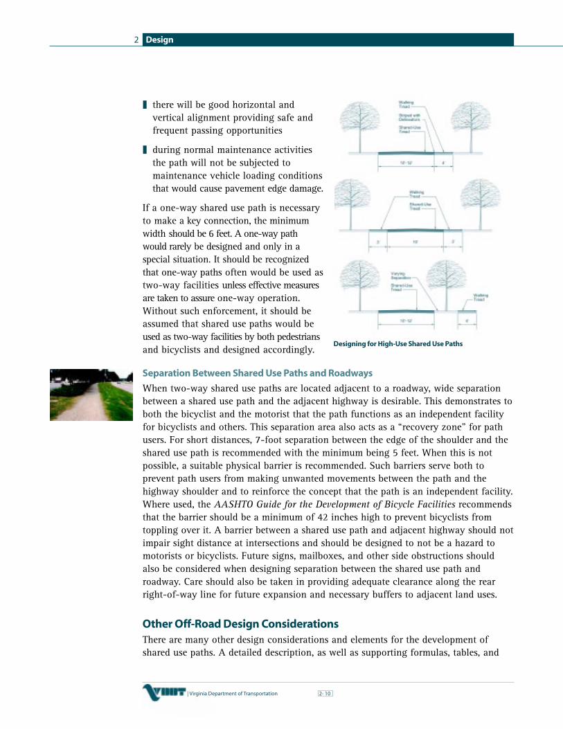
Design2
10| Virginia Department of Transportation 2-
❚ there will be good horizontal andvertical alignment providing safe andfrequent passing opportunities
❚ during normal maintenance activitiesthe path will not be subjected tomaintenance vehicle loading conditionsthat would cause pavement edge damage.
If a one-way shared use path is necessaryto make a key connection, the minimumwidth should be 6 feet. A one-way pathwould rarely be designed and only in aspecial situation. It should be recognizedthat one-way paths often would be used astwo-way facilities unless effective measuresare taken to assure one-way operation.Without such enforcement, it should beassumed that shared use paths would beused as two-way facilities by both pedestriansand bicyclists and designed accordingly.
Separation Between Shared Use Paths and Roadways
When two-way shared use paths are located adjacent to a roadway, wide separationbetween a shared use path and the adjacent highway is desirable. This demonstrates toboth the bicyclist and the motorist that the path functions as an independent facilityfor bicyclists and others. This separation area also acts as a “recovery zone” for pathusers. For short distances, 7-foot separation between the edge of the shoulder and theshared use path is recommended with the minimum being 5 feet. When this is notpossible, a suitable physical barrier is recommended. Such barriers serve both toprevent path users from making unwanted movements between the path and thehighway shoulder and to reinforce the concept that the path is an independent facility.Where used, the AASHTO Guide for the Development of Bicycle Facilities recommendsthat the barrier should be a minimum of 42 inches high to prevent bicyclists fromtoppling over it. A barrier between a shared use path and adjacent highway should notimpair sight distance at intersections and should be designed to not be a hazard tomotorists or bicyclists. Future signs, mailboxes, and other side obstructions shouldalso be considered when designing separation between the shared use path androadway. Care should also be taken in providing adequate clearance along the rearright-of-way line for future expansion and necessary buffers to adjacent land uses.
Other Off-Road Design ConsiderationsThere are many other design considerations and elements for the development ofshared use paths. A detailed description, as well as supporting formulas, tables, and
Designing for High-Use Shared Use Paths

Design 2
| Virginia Department of Transportation 112-
figures are well documented in AASHTO’s Guide for the Development of BicycleFacilities and the VDOT Road Design Manual. The following summarize some of thesekey elements:
Design Speed
Shared use paths should be designed for aselected speed that is at least as high as thepreferred speed of the faster bicyclists. Ingeneral, a minimum 20 mph design speedshould be used. When a downgrade exceeds4 percent or where strong prevailingtailwinds exist, a design speed of 30 mphor more is advisable.
Horizontal Alignment
Most shared use paths built in the United States must meet the requirements of theAmericans with Disabilities Act (ADA). ADA guidelines require that cross slopes notexceed 2 percent to 3 percent to avoid the severe difficulties that greater cross slopescan create for people using wheelchairs, walkers, canes, etc. Thus, for most shared usepaths, the maximum superelevation rate will be 3 percent. When transitioning a 3percent superelevation, a minimum 25 foot transition distance should be providedbetween the end and beginning of consecutive and reversing horizontal curves.
Grade
In keeping with ADA guidelines, grades on shareduse paths should be kept to a minimum, especiallyon long inclines. Grades greater than 5 percent areundesirable because the ascents are difficult formany bicyclists to climb and the descents causesome bicyclists to exceed the speeds at which theyare competent or comfortable. On some shared use paths, where terrain dictates,designers may need to exceed the 5 percent grade recommended for bicycles for someshort sections.
Sight Distance
To provide bicyclists with an opportunity to see and react to the unexpected, a shareduse path should be designed with adequate stopping sight distances. Minimum stoppingsight distance for various design speeds, vertical and horizontal curves, and grades needto be considered to ensure safe breaking distance on a shared use path.
Bicyclists frequently ride side-by-side on shared use paths, and on narrow pathsbicyclists have a tendency to ride near the middle of the path. For these reasons, andbecause of the higher potential for bicycle crashes, lateral clearances on horizontalcurves should be calculated based on the sum of the stopping sight distances for
Desirable Minimum Radii for Paved Shared Use PathsBased on 15° Lean Angle
Design Speed (V) Minimum Radius®mph feet
12 36
20 100
25 156
30 225
Maximum Grade Lengths
5 to 6% For up to 800 feet7% For up to 400 feet8% For up to 300 feet9% For up to 200 feet10% For up to 100 feet11+% For up to 50 feet

Design2
12| Virginia Department of Transportation 2-
bicyclists traveling in opposite directions around the curve. Where this is not possibleor feasible, consideration should be given to widening the path through the curve,installing a yellow center line stripe, installing a “Curve Ahead” warning sign inaccordance with the MUTCD, or some combination of these alternatives.
Path-Roadway Intersections
Intersections between paths and roadways are often the most critical issue in shared usepath design. Shared use paths should cross roadways as close to an intersecting roadas practical. This allows for good sight distances for both motor vehicle operators and bicyclists.In addition, a minimum buffer of 4 feet from the edge of the parallel travelway is requiredto provide the necessary separation between motor vehicles and bicyclists at intersections. Asthe path approaches the crossing it should be aligned with the destination of thecrossing on the other side of the road. Curb cuts should be appropriately aligned and bethe same width as the path. The crossing should also be as perpendicular as possibleto the road being crossed. Normally, two curb cuts are recommended at each cornerwhere a path crosses an intersection. Sight distance should be evaluated and soundengineering judgment must be used in locating crossings.
Due to the potential conflicts at these junctions, careful design is of paramountimportance to the safety of path users and motorists. Each intersection is uniqueand will require sound engineering judgment on the part of the designer as to theappropriate solution. The AASHTO guide provides examples and guidelines forvarious intersection treatments.
Signing and Marking
Adequate signing and marking are essential on shared use paths, especially to alertbicyclists to potential conflicts and to convey regulatory messages to both bicyclistsand motorists at highway intersections. Both advanced crossing and crossing warningsigns are needed on roadways to provide appropriate warning to the motorists of theupcoming path intersection. In addition, guide signing on a path, such as to indicatedirections, destinations, distances, route numbers, and names of crossing streets,should be used in the same manner as they are used on highways. In general, uniformapplication of traffic control devices, as described in the MUTCD, provides minimumtraffic control measures that should be applied.
Pavement Structure
The pavement structure should be designed to accommodate occasional maintenanceand emergency vehicles. Hard, all weather pavement surfaces are sometimes preferredover those of crushed aggregate, sand, clay, or stabilized earth since these materialsprovide a much lower level of service and require higher maintenance. Some surfacetreatments may be appropriate to introduce a particular theme or gain a certain aestheticquality for a shared use path. Finally, where the path intersects gravel roadways anddriveways, 3-foot paved aprons on the roadway or driveway approaches arerecommended to keep debris off the path and minimize pavement damage.

Design 2
| Virginia Department of Transportation 132-
Structures
On new structures, the minimum clear width should be the same as the approachshared use path plus the minimum 2-foot wide clear areas on both sides of the path.The AASHTO Guide for the Development of Bicycle Facilities recommends railings,fences, or barriers on both sides of a path on a structure be a minimum of 42 inches(3.5 feet) high. In situations where the structure crosses a high speed or high volumeroad or objects are subject to being thrown off the structure, it is recommended thatthe path be totally enclosed with fencing. Totally enclosing a path may also bedesirable in other areas such as a waterway crossing.
Drainage
The recommended minimum pavement cross slope of 2 percent adequately providesfor drainage. Sloping in one direction instead of crowning is preferred and usuallysimplifies the drainage and surface construction. A smooth surface is essential toprevent water ponding and ice formation. On unpaved shared use paths, particularattention should be paid to drainage to avoid erosion.
Lighting
Lighting for shared use paths is important and should be considered where nightusage is expected, such as paths serving college students or commuters, and athighway intersections. Lighting should also be considered through underpasses ortunnels and when nighttime security could be an issue.
Restriction of Motor Vehicle Traffic
Shared use paths may need some form of physical barrier at highway intersections toprevent unauthorized motor vehicles from using the facilities. Provisions can be madefor a lockable, removable (or reclining) barrier post to permit entrance by authorizedvehicles. Other entrance treatments can be designed to discourage motor vehicle access,maintain emergency access, and act as an entrance treatment to a shared use facility.
Maintenance
A well cared for facility is usually a well-used facility. Maintenance is an importantconsideration for all transportation facilities including on-road bicycle facilities andshared use paths. Good maintenance practices, such as periodic sweeping, surfacerepairs, tree pruning, mowing, trash removal, litter pick-up, new pavement markings,etc. are critical in the success of bicycle facilities. Maintenance operations are usuallyundertaken by the locality or governing agency. In some instances, nonprofit groups,civic groups, and private organizations (i.e. bike clubs) partner with the locality byassisting in the smaller maintenance tasks.
BEST PRACTICES 14

Design2
14| Virginia Department of Transportation 2-
Selecting Bicycle Facility Types
Selecting the most appropriate bicycle facility type is dependent on many factors, includingtargeted user group, specific corridor conditions, potential impacts, and facility cost.The Federal Highway Administration developed procedures to assist transportationengineers and planners in making appropriate recommendations for on-road bicyclefacilities in its publication Selecting Roadway Design Treatments to Accommodate Bicycles.VDOT has incorporated the majority of these recommendations into the VDOT Road DesignManual. The following information has generally been drawn directly from the FHWApublication.
Selecting a Design TreatmentThe FHWA report recommends the use of the following five basic types of facilities toaccommodate bicyclists depending on the design parameters of the roadway being evaluated:
Shared Lane
Shared motor vehicle/bicycle use of a “standard” width travel lane.
Wide Outside Lane
Also knows as wide curb lane, an outside travel lane with a width of at least 14 feet.
Bike Lane
A portion of the roadway designated by striping, signing, and/or pavement markingsfor preferential or exclusive use of bicycles. On urban projects the bike lane width isconsidered the distance from the face of the curb to the bike lane stripe or the distancebetween the parking stall delineation and the bike lane stripe.
Shoulder
A paved portion of the roadway to the right of the edge stripe on which bicyclists mayride. These areas are not marked or signed as bike lanes.
Separate Bike Path
A facility physically separated from the roadway and intended for bicycle use.
Bicycle Facilities Terms
The shared lane, wide outside lane, or shoulders types may be appropriate designswithin AASHTO’s shared roadway (no bikeway designation) categoryThe bike lane types are the sameAll on-road treatments may be supplemented with a route designation and signage(the signed shared roadway category)The separate bike path correlates to AASHTO’s shared use path
✔
✔
✔
✔

Design 2
| Virginia Department of Transportation 152-
The “look-up” tables on the following pages have been directly taken from SelectingRoadway Design Treatments to Accommodate Bicycles and are also presented in theVDOT Road Design Manual. Tables 1 through 6 suggest appropriate design treatmentsgiven various sets of traffic operational and design factors and environment. Thedesign treatments are considered “desirable widths” by the FHWA. There are threebasic types of roadway environments presented in the tables:
Basic Roadway Environments
Urban Urban Ruralwithout parking with parking
Controlled-access freeways are not addressed by the tables and require specialconsideration. In these cases the traffic parameters affecting bicycle travel may be toooverwhelming for Group B/C bicyclists and may dictate the selection of an alternativeroute or consideration of an adjacent shared use path.
✔ ✔ ✔

Design2
16| Virginia Department of Transportation 2-
Table 1: Group A Bicyclists, Urban Section, No Parking
average average annual daily traffic (AADT) volumemotor less than 2,000 2,000–10,000 over 10,000vehicle adequate inadequate adequate inadequate adequate inadequateoperating sight sight sight sight sight sightspeed distance distance distance distance distance distance
truck, bus, rv truck, bus, rv truck, bus, rvless than sl sl wc wc sl wc wc wc wc wc wc wc30mph 12 12 14 14 12 14 14 14 14 14 14 14
30-40 wc wc wc wc wc wc wc wc wc wc wc wcmph 14 14 15 15 14 15 15 15 14 15 15 15
41-50 wc wc wc wc wc wc sh sh wc wc sh shmph 15 15 15 15 15 15 6 6 15 15 6 6
over sh sh sh sh sh sh sh sh sh sh sh sh50 mph 6 6 6 6 6 6 6 6 6 6 6 6
Table 2: Group A Bicyclists, Urban Section, With Parking
average average annual daily traffic (AADT) volumemotor less than 2,000 2,000–10,000 over 10,000vehicle adequate inadequate adequate inadequate adequate inadequateoperating sight sight sight sight sight sightspeed distance distance distance distance distance distance
truck, bus, rv truck, bus, rv truck, bus, rvless than wc wc wc wc wc wc wc wc wc wc wc wc30mph 14 14 14 14 14 14 14 14 14 15 15 14
30-40 wc wc wc wc wc wc wc wc wc wc wc wcmph 14 14 15 15 14 15 15 15 14 15 15 15
41-50 wc wc wc wc wc wc sh sh wc wc sh shmph 15 15 15 15 15 16 16 16 15 15 16 16
over50 mph na na na na na na na na na na na na
wc and sl widths represent
“usable widths” of outer
lanes, measured from lane
stripe to edge of gutter pan,
rather than to the face of
curb. If no gutter pan is
provided, add 1 ft. minimum
for shy distance from the
face of curb.
wc widths represent “usable
widths” of outer travel lanes,
measured from the left edge
of the parking space (8 to 10
ft. minimum from the curb
face) to the left stripe of the
travel lane.
wc and sl widths represent
“usable widths” of outer
lanes, measured from lane
stripe to edge of the
pavement if a smooth, firm,
level shoulder is adjacent. If
rough or dropped pavement
edges or a soft shoulder
exists, add 1 ft. minimum for
shy distance from the edge
of the pavement.
Table 3: Group A Bicyclists, Rural Section
average average annual daily traffic (AADT) volumemotor less than 2,000 2,000–10,000 over 10,000vehicle adequate inadequate adequate inadequate adequate inadequateoperating sight sight sight sight sight sightspeed distance distance distance distance distance distance
truck, bus, rv truck, bus, rv truck, bus, rvless than sl sl wc wc sl wc wc wc wc wc sh sh30mph 12 12 14 14 12 14 14 14 14 14 4 4
30-40 wc wc sh sh wc wc sh sh sh sh sh shmph 14 14 4 4 14 15 4 4 4 4 4 4
41-50 sh sh sh sh sh sh sh sh sh sh sh shmph 4 4 4 4 6 6 6 6 6 6 6 6
over sh sh sh sh sh sh sh sh sh sh sh sh50 mph 4 6 6 4 6 6 6 6 6 6 6 6

Design 2
| Virginia Department of Transportation 172-
wc widths represent “usable
widths” of outer lanes, measured
from lane stripe to edge of
gutter pan, rather than to the
face of curb. If no gutter pan
is provided, add 1 ft. minimum
for shy distance from the face
of curb. bl widths represent the
minimum width from the curb
face. For VDOT projects, the bike
lane stripe will lie 4 feet minimum
from the edge of the gutter pan.
The bike lane stripe will lie 5 feet
minimum from the face of curb.
wc and sl widths represent
“usable widths” of outer
lanes, measured from the left
edge of the parking space (8
to 10 ft. minimum from the
curb face) to the left stripe of
the travel lane.
K E Y
widths are in feet
wc = wide curb lane
sh = shoulder
sl = shared lane
bl = bike lane
na = not applicable
Table 4: Group B/C Bicyclists, Urban Section, No Parking
average average annual daily traffic (AADT) volumemotor less than 2,000 2,000–10,000 over 10,000vehicle adequate inadequate adequate inadequate adequate inadequateoperating sight sight sight sight sight sightspeed distance distance distance distance distance distance
truck, bus, rv truck, bus, rv truck, bus, rvless than wc wc wc wc wc wc wc wc bl bl bl bl30mph 14 14 14 14 14 14 14 14 5 5 5 5
30-40 bl bl bl bl bl bl bl bl bl bl bl blmph 5 5 5 5 5 6 6 5 5 6 6 5
41-50 bl bl bl bl bl bl bl bl bl bl bl blmph 5 5 5 5 6 6 6 6 6 6 6 6
over bl bl bl bl bl bl bl bl bl bl bl bl50 mph 6 6 6 6 6 6 6 6 6 6 6 6
Table 5: Group B/C Bicyclists, Urban Section, With Parking
average average annual daily traffic (AADT) volumemotor less than 2,000 2,000–10,000 over 10,000vehicle adequate inadequate adequate inadequate adequate inadequateoperating sight sight sight sight sight sightspeed distance distance distance distance distance distance
truck, bus, rv truck, bus, rv truck, bus, rvless than wc wc wc wc wc wc wc wc bl bl bl bl30mph 14 14 14 14 14 14 14 14 5 5 5 5
30-40 bl bl bl bl bl bl bl bl bl bl bl blmph 5 5 5 5 5 6 6 5 6 6 6 6
41-50 bl bl bl bl bl bl bl bl bl bl bl blmph 6 6 6 6 6 6 6 6 6 6 6 6
over50 mph na na na na na na na na na na na na
Table 6: Group B/C Bicyclists, Rural Section
average average annual daily traffic (AADT) volumemotor less than 2,000 2,000–10,000 over 10,000vehicle adequate inadequate adequate inadequate adequate inadequateoperating sight sight sight sight sight sightspeed distance distance distance distance distance distance
truck, bus, rv truck, bus, rv truck, bus, rvless than sh sh sh sh sh sh sh sh sh sh sh sh30mph 4 4 4 4 4 4 4 4 4 4 4 4
30-40 sh sh sh sh sh sh sh sh sh sh sh shmph 4 4 4 4 4 6 6 4 6 6 6 6
41-50 sh sh sh sh sh sh sh sh sh sh sh shmph 6 6 6 6 6 6 6 6 6 6 6 6
over sh sh sh sh sh sh sh sh sh sh sh sh50 mph 6 6 6 6 8 8 8 8 8 8 8 8

Design2
18| Virginia Department of Transportation 2-
VDOT Design Process and Programs
In addition to developing bicycle design guidelines, the Virginia Department ofTransportation is committed to improving bicycling throughout the Commonwealththrough a defined design process and series of supporting programs. This sectionbriefly illustrates the design process and identifies these programs.
VDOT Design ProcessVDOT has an established design process for all roadway design projects including bicyclefacilities. VDOT’s Location and Design Division (L&D) designs or oversees the design of bicyclefacilities funded by VDOT and/or bicycle facilities within VDOT rights-of-way whetherthey be on-road or off-road. The roadway design process provides the opportunity for bicyclefacilities to be appropriately considered for all projects overseen by VDOT. As presented inChapter 1: Planning, only bicycle projects that are included in an adopted bicycle planwill be considered for inclusion in a highway project by VDOT. The design processprovides for continuous collaboration between VDOT, designers, localities, and the public.
VDOT Shoulder ImprovementsVDOT roadway design standards have recently been revised to specify pavedshoulders for construction of some new collector and local roadways thereby betteraccommodating bicycles. Designers are directed to provide a minimum 4-foot widepaved shoulder when the graded shoulder is 5 feet wide or greater and:
❚ the design year average daily traffic (ADT) is greater than 2,000 vehicles per day(VPD), with 5 percent or more truck and bus usage or
❚ the route is an AASHTO approved Interstate Bicycle Route or designated as abicycle route on a locality’s thoroughfare plan and the minimum graded shoulderwidth is 6 feet or greater.
Designers are directed to provide a 3-foot wide paved shoulder when the gradedshoulder is 4 feet wide and the design year ADT is greater than 2,000 VPD with5 percent or more truck and bus usage.
It is intended that the additional shoulder width will better accommodate bicyclingwithin the roadway corridor, as well as improve safety and reduce maintenance costsfor the overall corridor.
VDOT Bicycling Support
VDOT Bicycling Support
Bicycle Advisory Review Team State Bicycle/Pedestrian CoordinatorInternal Bicycle Task Force District Bicycle CoordinatorsBicycle Advisory Committee
✔
✔
✔
✔
✔
BEST PRACTICES 15

Design 2
| Virginia Department of Transportation 192-
Bicycle Accommodation Review Team (BART)
The Bicycle Accommodation Review Team (BART) is a multi-disciplinary team withinVDOT with extensive knowledge in aspects of bicycle planning, design, and safety.This team serves a quality control function by reviewing proposed plans to ensureconsistency and adequacy in bicycle facility design. Whether the plans are preparedinternally by VDOT or by an engineering firm, BART reviews:
❚ roadway plans for state-maintained roads that include a bicycle accommodation
❚ ISTEA or TEA-21 funded projects that include a bicycle component
Comprised of representatives from the State Bicycle and Pedestrian Program and theLocation and Design and Traffic Engineering Divisions, the Bicycle AccommodationReview Team meets regularly to review and comment on pending plans and recommendchanges as appropriate. If necessary, the team will meet on-site (with designers andlocalities) to review special site conditions and discuss and resolve design issues.
Internal Bicycle Task Force (ITF)
The Department’s Internal Bicycle Task Force (ITF) is responsible for ensuringconsistent implementation of the bicycle program within VDOT. The ITF periodicallyreviews, evaluates, and recommends modifications to VDOT’s bicycle policies andpractices. It is the primary venue by which information on bicycle facility designissues is disseminated internally through VDOT. The ITF consists of one representativefrom each of VDOT’s nine construction districts as well as representatives from thefollowing VDOT divisions:
Internal Bicycle Task Force
Transportation Planning Maintenance Structure and BridgeLocation and Design Secondary Roads EnvironmentalTraffic Engineering Urban Programming and Scheduling
Bicycle Advisory Committee (BAC)
VDOT established a Bicycle Advisory Committee (BAC) in 1989 as a forum for opencommunication and information exchange between the Department, other state/federalagencies, local/national bicycle advocates, and citizens regarding bicycling issuesacross the Commonwealth. Members of this committee meet periodically to discussVDOT policies, standards, and practices that affect the bicycling community. Thecommittee members, in turn, are asked to share this information with their respectiveorganizations, local officials, and other interested parties. In addition to keeping thebicycling community informed on VDOT’s activities and federal legislation/policiesthat affect VDOT, it provides an opportunity for committee members to address avariety of issues and foster mutual understanding. The committee works together onspecific projects as well. Together, the BAC has completed projects involving bicyclerace permits, “Share the Road” signs, and information material. Overall, the goal of thecommittee is to help provide a positive experience for bicycling in the Commonwealth.
✔
✔
✔
✔
✔
✔
✔
✔
✔

Design2
20| Virginia Department of Transportation 2-
State Bicycle/Pedestrian Coordinator
VDOT has had a designated State Bicycle/Pedestrian Coordinator since 1978 to overseeand coordinate all activities related to bicycle and pedestrian issues for theDepartment. The State Bicycle/Pedestrian Coordinator is with the TransportationPlanning Division and has one full-time assistant who is primarily dedicated to theDepartment’s Bicycle and Pedestrian Program. Responsibilities of the StateBicycle/Pedestrian Coordinator and the Assistant Coordinator include the following:
❚ administer the Bicycle and Pedestrian Program within the Department
❚ provide training to VDOT personnel on bicycle planning and design issues
❚ provide training and education to localities, planning district commissions, andothers on bicycle planning and design issues
❚ assist with the development of promotional and educational material regardingbicycling in Virginia
❚ develop and maintain the VDOT bicycle program web site and toll free number
❚ serve as primary liaison with other agencies, planning organizations, localities,and the public on bicycle activities and programs
❚ lead intradepartmental efforts to shape bicycling related policies and practiceswithin the Department
❚ coordinate extensively with other VDOT divisions to ensure statewide consistencywith VDOT’s bicycling policies and practices
❚ coordinate bi-monthly and annually with state bicycle/pedestrian coordinators fromother states
❚ coordinate and participate in the Bicycle Advisory Committee (BAC)
❚ coordinate and participate in the Internal Bicycle Task Force (ITF)
❚ serve as an active participant in the internal Bicycle Accommodation Review Team (BART)
❚ represent VDOT at state and national conferences on bicycle programs
District Bicycle Coordinators
Each of Virginia’s nine construction districts has a designated Bicycle/PedestrianCoordinator to assist with implementation of the Department’s Bicycle and PedestrianProgram. The coordinators also have other responsibilities within the district whetherit is transportation planning, traffic engineering, or roadway design. In general, theirrole in the bicycle and pedestrian program is to provide local support as needed toencourage, educate, and implement bicycling related efforts within their respectivedistricts. Responsibilities of the district bicycle coordinators include:
❚ act as liaison with the local bicycling community and local municipalities
VDOT Bicycle/Pedestrian Program
Phone:800-835-1203
Email:[email protected]

Design 2
| Virginia Department of Transportation 212-
❚ provide planning and design information and technical assistance
❚ coordinate with other VDOT districts and divisions to ensure safeaccommodations are provided and maintained for bicyclists and pedestrians
❚ participate in and support the State Bicycle and Pedestrian Program
❚ participate in the Internal Bicycle Task Force (ITF)
❚ review and comment on VDOT’s bicycle and pedestrian policies and practices
Contact the VDOT Bicycle/Pedestrian Coordinator for the most up to date list of VDOTDistrict Bicycle/Pedestrian Coordinators.

BEST PRACTICES 12
Intersection Improvement to BetterAccommodate Bicycles
D E S I G N
Bicycle Detection in Alexandria, VA
contact
City of Alexandria
Transportation and
Environmental Services
301 King St. City Hall
Rm 4130
Alexandria, VA 22314
703.838.4328
Under the Code of
Virginia, bicycles are
vehicles and need
to follow the same
laws as motor
vehicles. This can
be difficult for bicyclists at signalized
intersections as many loop detectors,
embedded in the pavement to detect the
presence of vehicles, do not detect the
presence of bicycles. VDOT and the City of
Alexandria have taken note!
With the construction of a new connector
road between the Capital Beltway and
Eisenhower Avenue in Alexandria, VDOT
and city traffic engineers not only set the
sensors for bicycles, they also installed
signs directing bicyclists to stop on a “T”
painted on the roadway to assist the
bicyclists in locating the detectors. This
small improvement has made a significant
difference for bicyclists using this popular
bicycle commuter route connecting
Alexandria and Fairfax County.
Based on the success of this one intersection
improvement, the City of Alexandria has
instituted a program to adjust the sensitivity of
the detector settings at other intersections
heavily used by bicyclists. Taking a hands-on
approach, members of the Alexandria
Bicycle Study Committee assist the city in
several ways. Not only do they identify
intersections in need of improvement,
they even assist city traffic technicians
adjust the detector settings by riding their
bicycles to an intersection and providing
real life conditions. These modifications
have contributed to an improvement in
the overall bicycling experience and truly
support bicycling as a mode of transportation.

BEST PRACTICES 13
Rails to Trails
D E S I G N
New River Trail State Park
contact
New River Trail
State Park
176 Orphanage Drive
Foster Falls, VA 24360
540.699.6778
www.dcr.state.va.us
Virginia’s longest
linear park and a
prime example of
an abandoned rail
corridor being
reinvigorated as a
recreational
greenway is the
New River Trial State Park. The 57 mile
converted rail trail meanders along the
banks of the New River, Chestnut Creek,
and Claytor Lake through the heart of the
Blue Ridge Mountains. Named as one of
50 Millennium Legacy Trails by the White
House, the New River Trail runs through
remote mountainous areas from Pulaski to
Galax in southwestern Virginia. The trail
features 28 trestles and 3 bridges, which
crisscross the New River and its tributaries.
The longest bridge, located at Fries Junction,
is 1,089 feet long. The majority of these
structures have been retrofitted to meet
the new transportation and recreational
needs of the corridor. Much of the trail
meanders along the New River with many
opportunities to enjoy its historic and
scenic characteristics. Over 700,000
visitors use the trail annually, making it
one of the highest use rail-trails in
the country.

BEST PRACTICES 14
D E S I G N
City of Lynchburg Adopt-A-Trail Program
contact
City of Lynchburg
Division of Parks
and Recreation
301 Grove Street
Lynchburg, VA 24501
www.ci.lynchburg.va.us/parksandrec/
The City of
Lynchburg is
located in the
center of Virginia
and has a population
of over 60,000. To
the east of the city are the beautiful Blue
Ridge Mountains that provide an abundance
of recreational opportunities including
bicycling. The City of Lynchburg Parks and
Recreation Department recognizes the
importance of maintaining bicycling and
hiking facilities to ensure the prosperity of
trails for years to come. Maintenance costs
can add up and become a deterrent to the
successfulness of a trail system. To that
end, the Department implemented an
“Adopt-A-Trail Program” to enlist the help
of trail volunteers to participate in the
maintenance of the facilities.
The first group of
volunteers was the
Linkhorne Middle
School Science
Club. The club used the Adopt-A-Trail
program for “hands on training” in ecology and
environmental responsibility. Since then, the
Boy Scouts have also taken an active role in
the program and account for almost
seventy-five percent of the volunteers. The
Adopt-A-Trail
volunteers spend a few hours a day, two or
more times a year, cleaning their designated
section of the trail, generally a half mile.
Some volunteers participate in additional
trail work, such as mowing, tree and shrub
pruning, and special projects if needed. The
Park and Recreation Department provides
volunteers with all the necessary equipment,
supplies, training, guidelines, and registration
materials. The Adopt-A-Trail program has
capitalized on a partnership with the trail
users and successfully reinforced a sense of
community pride for the City of Lynchburg.

BEST PRACTICES 15
In 1997, the
Virginia General
Assembly passed
a resolution
recommending that VDOT designate a bicycle
and pedestrian coordinator for each of its nine
districts. VDOT’s Hampton Roads District built
on this resolution by establishing a district
bicycle and pedestrian advisory committee
— the Hampton Roads District Pedestrian
and Bicycle Advisory Committee (PABAC).
The committee is composed of citizens and
public officials with an interest in encouraging
bicycle and pedestrian projects and programs.
The committee’s mission statement is:
“To foster reduced traffic congestion and
more livable communities by encouraging
the safe and continued use of bicycle and
pedestrian facilities through the multi-faceted
education of the pedestrian and bicycling
community, vehicle operators, policy makers,
and facility designers for the purposes of
ensuring the recognition of pedestrians
and bicyclists as necessary components of
an intermodal transportation system.”
Since its inception, the committee has been
busy working with localities, Planning District
Commissions, and local citizens to address
the interest and needs of the bicycle and
D E S I G N
PABAC — Hampton Roads DistrictPedestrian and Bicycle Advisory Committee
contact
VDOT Hampton Roads District
1700 North Main Street
Suffolk, VA 23434
757.925.2481
Regional Design Approach
pedestrian community regarding issues of
planning, design, and maintenance of
facilities at both the local and regional
levels. The regional cooperation among
municipalities fostered by the formation of
this committee has helped plan and implement
many bicycle projects and programs within
the Tidewater area. Projects with a regional
scope often have a greater chance of
receiving federal enhancement monies.
Two current projects spearheaded by the
Advisory Committee include: (1) the creation
of a Hampton Roads District Bicycle Plan
and (2) creation of a project development
process that will assist localities and users
provide input on specific projects. PCBAC
has been a tremendous asset to VDOT’s
Hampton Roads District and continues to
blaze the way for bicycling in this region.

Education, Encouragement, Enforcement 3
| Virginia Department of Transportation 13-
BEST PRACTICES 16
Education, Encouragement, Enforcement
Introduction
The overall success of integrating bicycling into the local transportation network notonly depends on good planning, design, and the ability to obtain funding, but alsorelies heavily on supporting education, encouragement, and enforcement programs(the “3Es”). In many instances these are grassroots programs that generate localinterest in bicycle safety and promote the many benefits of bicycling. Localgovernment agencies (i.e., police, parks and recreation departments, etc.) and privateindustry (i.e. local hospitals) sponsor programs. Many state agencies in Virginia alsoplay an important role in these programs. Some of the key agencies include:
❚ Virginia Department of Transportation
❚ Virginia Department of Rail and Public Transportation
❚ Virginia Department of Education
❚ Virginia Department of Health
❚ Virginia Department of Motor Vehicles
❚ Virginia Department of Conservation and Recreation
❚ Virginia Tourism Corporation
This chapter identifies education, encouragement, and enforcement programs thatsupport a comprehensive bicycle plan. Checklists of popular 3E programs are providedthroughout this chapter. When developing bicycling education or encouragementprograms, it is important to keep the fundamental benefits of bicycling in mind.
Transportation Benefits
Bicycling can play an important role in the overall transportation system.It is an easy way to complete short trips, such as errands orcommuting, while helping to reduce traffic congestion. In addition,people without a driver’s license (i.e., teenagers and seniors) or access toa motor vehicle may need to rely on bicycle travel as their mainmode of transportation.
Health Benefits
Bicycling is recognized as an excellent form of physical activity, and it can helpprevent and/or control the chronic conditions that lead to cardiovascular disease,including diabetes, obesity, high blood pressure, and high blood cholesterol, throughincreased physical fitness. The health benefits associated with bicycling should behighlighted to encourage bicycling at the local level.
Education, Encouragement, Enforcement3
2| Virginia Department of Transportation 3-
Economic Benefits
Organized bicycle tours and bicycle facilities can economicallybenefit communities. When touring, bicyclists and their familiesoften spend money for food, accommodations, and souvenirs.Bicycle tours bring tourists to communities that may otherwise not seea great deal of tourism. Bicycle facilities, especially popular shareduse paths, have also proven to attract tourists and related businessessuch as bicycle shops, restaurants, and bed-and-breakfast inns.
Community Benefits
Bicycling can help define a community’s character. A communitywith an extensive bicycle network will tend to generate a significantamount of local bicycle travel. This tends to translate to a morehealthy community. In addition, bicycling promotes moreinteraction among people in the community and helps create amore friendly environment.
Recreational Benefits
Bicycling as a form of recreation is important to Virginians. In the 2000 VirginiaOutdoors Survey, bicycling was rated the sixth most popular form of outdoorrecreation in the Commonwealth, with 39.2% of the population participating.Homebuyers and businesses often seek out communities offering bicycle facilitiesbecause of the transportation and/or recreation benefits.
Education
Bicycling education programs form the foundation of communities supportingbicycling. Comprehensive public information and education programs are often usedto raise community awareness and improve both bicyclists’ riding and traffic skills andmotorists’ attitude toward bicyclists. Ensuring that both bicyclists and motoristsunderstand and practice the fundamental “rules of the road” is one way of accomplishingthis goal. To ensure a safer bicycling experience, public education programs frequentlyaddress effective riding principles and the use of safety equipment such as helmets andreflectors. Common bicycle education programs include:
Education
“Bike Smart! Virginia” BikeWalk Virginia conferencesBicycle safety rodeos Public service announcementsHelmet programs Ride-Like-a-Pro safety eventsCommunity youth bicycle safety Adult bicycle programsinitiatives
✔
✔
✔
✔
B E S T P R AC T I C E S 1 7
B E S T P R AC T I C E S 1 8
BEST PRACTICES 19
✔
✔
✔
✔

Education, Encouragement, Enforcement 3
| Virginia Department of Transportation 33-
Education programs can be targeted towards an array of audiences including varyingage and bicycling skill levels (children, teens, and adults), as well as varyingsocioeconomic sectors of the community. Institutions such as universities and hospitalsoften provide bicycle safety and skill programs. Local government officials and stateagencies concentrate on providing information regarding the benefits of bicycling. Thefollowing examples demonstrate the range of educational programs in Virginia.
“Bike Smart! Virginia”
“Bike Smart! Virginia” is a comprehensive program to promotebicycle helmet use among children in Virginia. The cornerstoneof the program is a guide book that equips educators and othercommunity leaders with resources encouraging helmet use. Theresource guide provides injury facts and legislation, essentialcomponents of childhood bicycle helmet programs, safe ridingtips, sample classroom activities, and national, state, and localresources. This program is currently funded by a 402 FederalHighway Safety Grant. The guidebook is distributed by theVirginia Department of Health.
BikeWalk Virginia Conferences
The BikeWalk Virginia Conference is an annual event organized by BikeWalk Virginiafor citizen advocates; local, state, and federal agency officials; educators; public safetyofficials; transportation and recreation planners; and others who want to makeVirginia “biking and walking friendly.” The conference provides a series of workshopsand presentations promoting current programs in support of bicycling and walking inVirginia and elsewhere.
Bicycle Safety Rodeos
Bicycle rodeos are conducted across the state and provide a fun environment for teachingthe benefits of bicycling and bicycling safety skills to the entire community. Rodeos canbe developed and organized for small or very large groups, and they provide a forumfor other community programs such as bicycle registration, health fairs, book fairs, motorvehicle driver’s license renewal, etc. Area hospitals and other health care providers arefrequently involved in sponsoring bicycle rodeos as a measure to help reduce headtrauma injuries through the proper use of bicycle helmets and safe bicycling practices.
Public Service Announcements
Public service announcements can be an effective way to educate the community on theimportance of bicycle safety. For example, during the summer of 2000, the VirginiaDepartment of Health sponsored local public service announcements about bicycle helmetuse which were broadcast on local radio stations. Public television stations may be willingto broadcast pre-recorded educational messages as well. Using local and nationalrole models, such as sports heroes, can be an effective way to gain the attention ofchildren and adolescents and deliver a positive message regarding bicycle safety.

Education, Encouragement, Enforcement3
4| Virginia Department of Transportation 3-
BEST PRACTICES 22
Helmet Programs
Helmet use is an important consideration in bicycle safety.Bicycle helmet programs can include demonstrations on properfit, public service announcements, reduced helmet prices, andfree helmet giveaways. Local hospitals, health care providers,state agencies, private organizations, and local police departmentsoften play an active role in promoting, organizing, andparticipating in safe helmet programs.
Ride Like a Pro Safety Events
“Ride Like A Pro” safety events are part of a national program to promote measuresthat reduce crash-related bicycle fatalities and injuries suffered by children andadolescents. The premise of this program is to increase bicycle safety awareness andskills through a variety of training events and to promote bicycle safety by generatingmedia interest. These events depend on collaboration between local, regional, andstate organizations, as well as the private sector, to deliver high impact and highlyvisible media events. Professional athletes often play a tremendous role in these eventsand provide the much needed “link” to deliver the message to today’s youth.
Community Youth Bicycle Safety Initiatives
Bicycle safety can also be targeted locally through communityyouth bicycle safety initiatives. These programs are on-goingand continually reinforce bicycle safety through local youthgroups, school groups, local recreation programs, andcommunity police programs. Helmet use, “rules of the road,”and local bicycle rides are often organized by youth groupsand local volunteers.
Adult Bicycle Programs
Bicycle programs targeted to adults are needed to educate adult bicyclists on today’s“rules of the road” for bikes and the importance of helmet use for all bicyclists. Thereare many programs and organizations that have materials and courses targetedtowards adult bicyclists. For example, the League of American Bicyclists offers aNational Bicycle Education Program for adults.
Encouragement
Programs and initiatives that encourage bicycling are also an important element ofcreating a bicycle friendly community. One way to promote and encourage bicycling isto provide assistance in the form of maps, brochures, and/or travel guides to makebicycling more approachable and enjoyable for novice and advanced bicyclists alike.Another effective technique is to highlight the multitude of benefits bicycling provides.
BEST PRACTICES 23
B E S T P R A C T I C E S 21
B E S T P R A C T I C E S 20

Education, Encouragement, Enforcement 3
| Virginia Department of Transportation 53-
Ways to encourage bicycling include:
Encouragement
Bicycle maps/brochures Statewide or regional bicycle guidesWeb site information Bike to Work WeekBikes with transit Bicycle toursBicycle clubs Health benefits
Descriptions of these programs and examples from Virginia are highlighted below.
Bicycle Maps/Brochures
Bicycle maps can provide a variety ofinformation to encourage bicycling. Specificbicycle routes are often highlighted in regionaland local bicycle brochures, as well as otherattractions or destinations such as scenic roads,intermodal connections, historic sights, and recreational areas. Area accommodationsand unique events are often featured within a bicycling brochure as well.
The 2001/2002 Virginia Bicycling Guide
The 2001/2002 Virginia Bicycling Guide is a comprehensivesummary of bicycling opportunities in Virginia. The guide isorganized into seven geographic regions, presents briefdescriptions of popular road and mountain bike rides alongwith directions and contacts for further information withineach region, and offers general tips for safe bicycling. Theguide is jointly developed and sponsored by the VirginiaDepartment of Transportation and the Virginia Tourism Corporation.
Web Site Information
The Internet can be an excellent source of information to encourage bicycling.Established bicycle routes, local bike programs, and upcoming bicycle events such asorganized rides and bicycle rodeos can be periodically posted on the web. Forexample, VDOT currently maintains a web page for its bicycle and pedestrian programand provides a variety of bicycle-related information and resources. In addition, manybike clubs in Virginia maintain web sites to encourage participation and keep membersinformed on upcoming events. The appendix provides some popular websites forbicycling resources.
Bike to Work Week
Bike to Work Week is a national event encouraging commuters to bike to work duringa designated week in May. Bike to Work Week is intended to demonstrate that bicyclecommuters have the potential to help alleviate traffic congestion, reduce parkingproblems, and support healthy communities. At the local level, communities can
www.VirginiaDOT.org
✔
✔
✔
✔
✔
✔
✔
✔
BEST PRACTICES 24

Education, Encouragement, Enforcement3
6| Virginia Department of Transportation 3-
BEST PRACTICES 28
BEST PRACTICES 26
sponsor special events to generate awareness of Bike to WorkWeek. These events can include breakfast receptions with localofficials, organized rides, and raffles for bicyclists participating inBike to Work Week. Out of the success of Bike to Work Week, somecommunities have designated a particular day per month, week permonth, or entire month for bicycle awareness.
Bikes with Transit
Provisions for bicycles on transit services help encourage bicycling and transit asalternative modes of transportation. Bicycle racks on buses and bicycle access to rapidtransit passenger cars will encourage some commuters to consider bicycling tostations instead of driving. Providing secure and safe bicycle parking at intermodalstations, bus stops, and train stations also reinforces bicycling as a viable mode ofaccess to transit.
Bicycle Tours
Organized bicycle tours are a popular means to encouragebicycling in Virginia. Tours vary from short local rides for allbicyclist levels to major multi-day events. Virginia has a seriesof well known bicycle tours including Bike Virginia, Pedal theParkway, the Great Peanut Festival, Fun Day on the Bay, andthe Fall Foliage Festival. These tours have been extremelysuccessful and not only showcase great biking in Virginia, butencourage the many communities that the tours go through tobecome actively involved in bicycling.
Bicycle Clubs
Local and regional bicycle clubs are often very active in bicycle education andencouragement. Bicycle clubs are a key advocacy group in developing local andregional bicycle networks. In addition to bicycle advocacy, bicycle clubs are oftendedicated to promoting health and fitness benefits of bicycling, as well as the sport ofbicycle racing. Bicycle clubs are also involved with volunteer efforts for traildevelopment, promotion, and maintenance.
Spot Improvement Programs
Bicycle spot improvement programs can assist in maintaining(trash removal, sweeping, pruning, etc.) a bicycle network andthus increase the potential use of the facility. Too often thelack of proper maintenance turns the best-designed bikefacility into one that is underused. Spot improvement programsprovide a mechanism for the public to inform the locality and/or facility manager about maintenance issues or problems.Successfully used in Virginia, this can be done via hotline,Internet, or mail-back post cards.
B E S T P R A C T I C E S 25
B E S T P R A C T I C E S 29
B E S T P R A C T I C E S 27

Education, Encouragement, Enforcement 3
| Virginia Department of Transportation 73-
✔
✔
✔
Enforcement
Enforcement of Virginia’s bicycle laws and local bicycle regulations is an importantelement in providing a safe bicycling environment. Like any other transportation system,uniform rules and regulations define user expectations and reduce the risk of injury. Rulesand regulations need to be easily accessible and taught through education andencouragement venues to ensure that bicyclists and motorists are aware of and followthe “rules of the road.” In Virginia, a bicycle is considered a vehicle when operated on aroadway. Thus, bicyclists and motorists basically have the same rights and duties, and thelaws governing traffic regulation apply equally to both. Bicyclists must obey the sametraffic laws as those who are operating motor vehicles and follow traffic signs, signals,lane markings, directions, etc. Bicycle laws and regulations must be readily enforced ina manner to encourage bicycle use.
Enforcement
Police on bikes Park rangers on bikesBicycle rules of the road Helmet ordinancesBicycle ticketing programs Bicycle crash reporting
Bicycle “Rules of Road”
Developing, adopting, and publicizing easy to understand “rules of the road” at thelocal level is the first step in any enforcement program. The VDOT web site providesa summary of state laws concerning bicycles and their use and safety tips that shouldbe incorporated into local bicycle programs. Bicycle “rules of the road” shouldtarget a wide audience including children, adolescents, adults, and seniors fromvarying backgrounds.
Example Safety Tips
Be a responsible bicyclist — obey all traffic control devices and use proper handsignals. Always ride with the flow of traffic.Dress safely — wear a helmet, wear bright colored clothing, and secure loose pant legs.Ride defensively — anticipate the actions of other road users and watch for road hazards.Pass vehicles with extreme care — turning vehicles may not see you.Be aware of motor vehicle blind spots whether riding or stopped at an intersection.Maximize your visibility at night — wear reflective clothing and apply reflectivetape to your bicycle.Walk your bicycle when you get into traffic situations beyond your cycling abilities.Exercise great caution when riding in bus traffic — watch out for busespulling to and from curbs and passengers getting on and off buses.Park your bicycle so you do not block sidewalks, handicap and building accesses, oremergency drives.Lock your bicycle — secure both wheels and the frame to a stationary object using a sturdy lock.Register or license your bicycle if required or provided by your community.
✔
✔
✔
✔
✔
✔
✔
✔
✔
✔
✔
✔
✔
✔
Education, Encouragement, Enforcement3
8| Virginia Department of Transportation 3-
Police on Bikes
Numerous police departments throughoutthe Commonwealth have successfullyintroduced bike patrols as part of theiroverall patrol efforts. These patrols haveproven to be a particularly positive wayfor police officers to interface with the community. Police on bikes can readily enforcelaws and regulations by quickly and effectively addressing bicycle infractions. Bicyclepolice patrols have an added responsibility of following the “rules of the road” anddemonstrating proper bicycling etiquette by setting an example for other bicyclists inthe community. As far as crime fighting goes, the bicycle has become known to someas the “stealth” vehicle of police departments. An officer can ride up to a crime inprogress without being as readily detected and easily chase down fleeing perpetratorsin areas where vehicles cannot travel. Bike patrols have also proven effective ineducational, encouragement, and community outreach efforts.
Park Rangers and Others on Bikes
Park rangers on bikes can be instrumental in enforcing many of the rules andregulations at state and national parks. Parks with shared use bicycle facilities canparticularly benefit from this type of enforcement. Park rangers on bikes can educateshared use path users on proper use of the bike facility and increase the overall safetyof the facility. Emergency response staff have also adopted the bicycle as an effectivemeans of transportation at gatherings. For instance, Emergency Medical Technicians(EMT’s) use bicycles to patrol during major events, such as fairs, road races, and parades.
Helmet Ordinances
Bicycle helmet ordinances requiring young bicyclists to wear approved helmetscan help to ensure bicycle safety. Helmet programs that provide free or reduced pricebicycle helmets may be needed to support a helmet ordinance to make sure helmetsare easily available to everyone. The Code of Virginia allows jurisdictions to passordinances to require every person fourteen years of age or younger to wear aprotective helmet whenever riding or being carried on a bicycle on any highway,sidewalk, or public bicycle path.
Virginia Jurisdictions with Helmet Ordinances
Arlington County Fairfax CountyPrince William County York CountyCity of Alexandria Town of BlacksburgCity of Falls Church City of ManassasCity of Newport News City of Virginia Beach
✔
✔
✔
✔
✔
✔
✔
✔
✔
✔
BEST PRACTICES 30
BEST PRACTICES 31

Education, Encouragement, Enforcement 3
| Virginia Department of Transportation 93-
Bicycle Ticketing Programs
Ticketing illegal bicycle operations is sometimes needed to reinforce the importance ofthe “rules of the road.” Warnings may be more appropriate in most cases, allowing thebicyclist to recognize their mistake without paying a fine. At the national level, somepolice departments administer “tickets” that are coupons redeemable for discounted orfree bicycle helmets for youth that are spotted without a helmet. Other communitiesdistribute leaflets with the “rules of the road” or “safety tips” as a warning to bicyclistsnot obeying the traffic laws and bicycle regulations.
Bicycle Crash Reporting
Reporting, cataloging, and analyzing high bicycle crash locations can help determineappropriate mitigating measures to improve bicycle travel. Bicycle crashes are oftennot reported unless they involve serious injury and the deployment of emergencyresponse units. Efforts to report all bicycle crashes can assist in identifying potentialsafety hazards for other bicyclists. The bicycling community and local bike clubs canassist localities in identifying these areas.

Health Benefits
BEST PRACTICES 16
Lack of physicalactivity is one ofthe major risk factorsfor cardiovasculardiseases and manyother chronicdiseases. Lifestylemodifications, suchas increasingphysical activity, can
help prevent these diseases and are a toppriority for the Centers for Disease Control andPrevention (CDC). Bicycling is recognized as anexcellent form of physical activity and canhelp prevent and/or control the chronicconditions that lead to cardiovascular disease,including diabetes, obesity, high blood pressure,and high blood cholesterol through increasedphysical fitness. The Virginia Department ofHealth (VDH) has taken note and has beenactively promoting lifestyle modificationsand infrastructure improvements toreinforce a healthy lifestyle.
“In 1998, 37 percent of all deaths in Virginia,almost 19,500 people, resulted fromcardiovascular disease”.
— Virginia Department of Health
VDH, throughfunding providedby the CDC, hasundertaken the“Virginia Cardio-vascular HealthProject” (VCHP)to quantify thedisease and
identify implementable strategies to reducethe risk of cardiovascular diseases. As part of
E D U C A T I O N • E N C O U R A G E M E N T • E N F O R C E M E N T
Cardiovascular Healthy Hickory HillsCommunity Project
contact
Virginia Department
of Health
Division of Chronic Disease
Prevention and Nutrition
1500 E. Main Street
Richmond, VA 23219
this project, VDH provided funding to RichmondCity Health Department for the “CardiovascularHealthy Hickory Hills Community Project.”This project is an ongoing pilot project withan eye on implementing environmental,policy, and social strategies to increase thecardiovascular health of the citizens in thesurrounding communities.
The initial focal point of the project quicklybecame the Hickory Hills CommunityCenter, which rests in the middle of tenlow-income communities with a highminority population. The community centerprovides a central gathering location andpresents an excellent forum for educationaland recreational programs. One of the keyresolutions of the project is to provideincreased bicycle and pedestrian opportunitiesin and around the community center withkey connections to each of the surroundingcommunities. These enhancements wouldencourage bicycling and walking as formsof transportation and recreation forresidents and visitors, in essence improvingthe overall quality of life of the community.

Economic and Social Benefits
BEST PRACTICES 17
E D U C A T I O N • E N C O U R A G E M E N T • E N F O R C E M E N T
Shenandoah Valley Fall Foliage Bike Festival
contact
Shenandoah Fall
Foliage Bike Festival
P.O. Box 3187
Staunton, VA 24402
540.885.2668
www.bikevirginia.org
www.ShenandoahBike.org
The Shenandoah
Fall Foliage Bike
Festival draws over
1,200 bicyclists to
the incomparable
Shenandoah Valley
each autumn. The
festival draws
people of all walks of life for a memorable
weekend of on-road and off-road bicycling
and leaf peeping. The City of Staunton and
Augusta County partnered with the Bicycling
Education Association to begin the event;
beginning in 2001 the City of Staunton,
through the non-profit Tour de Shenandoah,
will organize and fund the festival to
ensure a successful event each year.
The tour is designed for bicyclists of all
abilities, and participants can choose routes
from 10 to 100 miles in length. Families are
also encouraged to attend with their young
children to participate in specially designed
ten-mile routes. Either along this route or
the lunch stop, children and adults can
learn bicycle safety tips taught by BikeSmart
Virginia instructors certified by the League
of American Bicyclists. All routes have rest
stops along the way, mechanical assistance,
and volunteer bike safety monitors to
ensure that everyone has a safe ride.
Since its inception, over 10,000 bicyclists
have enjoyed an active, healthy weekend
biking under a canopy of fall colors in the
Shenandoah Valley. As a side benefit, the
City of Staunton and Augusta County enjoy
tourism revenue year after year from this
event. It has been estimated the 1999
tour’s direct economic impact on the local
community was $186,000.

Touring — A Learning Experience
BEST PRACTICES 18
E D U C A T I O N • E N C O U R A G E M E N T • E N F O R C E M E N T
The Great Peanut Tour
contact
Emporia Bicycle Club
P.O. Box 668
Emporia, VA 23847
800.449.2453
The Great Peanut
Tour started in
1978 with 15 riders
and has grown to
over 1,100 riders from at least 20 states.
The purpose of the ride is to encourage
people to learn about the production and
harvesting of peanuts and to enjoy the
beautiful south side Virginia scenery. Each
of the rides is a circular route, starting
and ending at Cattail Creek Campground.
The distances vary from 13 to 81 miles
on moderately rolling to flat terrain. The
uniqueness of the ride comes from the
unusual water stops manned by over
40 volunteer families. At these stops, a
large variety of snacks are served including
cucumbers and pickled watermelon rinds.
Each night a campfire with entertainment
and marshmallow roasts is held.
In 1999, it was estimated each participant
generally spent, on an average, $105 in
surrounding communities as part of the
event. This represents over $100,000 as a
direct economic boost for the communities
that participate in the Great Peanut Tour.

BEST PRACTICES 19
Exploring the Chesapeake Bay by Bike
E D U C A T I O N • E N C O U R A G E M E N T • E N F O R C E M E N T
Tour de Chesapeake
contact
Tour de Chesapeake
P.O. Box 522
Mathews, VA 23109
www.tourdechesapeake.org
Special events help
promote bicycling in
the Commonwealth
and emphasize
healthy lifestyles.
The Tour de
Chesapeake is one
such event that began in May of 1997. Over
600 bicyclists converged on Mathews County
on the shore of Chesapeake Bay to enjoy
miles of flat, meandering, scenic back roads.
The event was born as a partnership
between Bike Virginia and local supporters.
The 4th Annual Tour de Chesapeake drew over
1,300 bicyclists wanting to explore this scenic
area at the slow pace of a bicycle ride. The
5th annual event in 2001 was organized and
run by Mathews County Sustainable Economic
and Environmental Development (MCSEED).
Many factors contribute to the success of
this event. The infectious hospitality of the
citizens of Mathews, well-stocked rest stops,
delicious meals, mileage options tailored for
all abilities, a bike safety rodeo for children,
bike safety workshops, and a chance to
take a river cruise all enhance this annual
bike event. The Tour de Chesapeake is a
model for the creation of other bicycling
events that can be managed entirely by the
local community.

BEST PRACTICES 20
Helmet Safety and Distribution
E D U C A T I O N • E N C O U R A G E M E N T • E N F O R C E M E N T
Bike Virginia Helmet Distribution Program
contact
Bike Virginia
P.O. Box 203
Williamsburg, VA 23187
757.229.0507
www.bikewalkvirginia.org
One of the mostimportant safetyfeatures forbicyclists of allages is a properlyfitted and approvedhelmet specificallydesigned for
bicycling. Bike Virginia has been doing itspart to help spread the word. The BikeVirginia helmet program gives helmets toyouths under age 17 in the towns, cities,and counties it visits when sponsoringbicycle events such as the annual BikeVirginia ride. Event registration fees coupledwith Virginia Department of Motor Vehiclemini-grants fund the helmet distributionprogram, a clear commitment of BikeVirginia and its participants to give back tothe communities through which they bike.
The helmets aredistributed by thelocal community,most often duringbike safety rodeosheld by parks andrecreation depart-ments, policedepartments, andother groups. BellSports makesavailable the previous
year’s models at a discounted price to groupsaffiliated with SAFEKIDS Coalitions. Thispartnership with Bell Sports has providedover 5,000 helmets for children in Virginia.
Many Virginia localities have adopted an“under 14 mandatory helmet” ordinance,
STATE WIDE
which makes this program even moreimportant. In some communities, policeofficers carry a few helmets in their carsand give them to children they see bikingwithout a helmet. Bike Virginia began thisprogram with the City of WilliamsburgPolice Department and is promoting itstatewide. In addition, many area hospitalssupport safe bicycling by providing helmetsat a discounted price or for free. Finally,adult helmet use is encouraged for not onlysafety purposes, but for the unmeasurable“role model” benefits.

BEST PRACTICES 21
Grass Roots-Youth Program
E D U C A T I O N • E N C O U R A G E M E N T • E N F O R C E M E N T
Spratley Middle SchoolBike Education Program
contact
Spratley Middle School
339 Woodland Road
Hampton, VA 23669
757.850.7248
Spratley Middle School, in Hampton, formed
the Spratley Middle School Bicycle Club in
January 1999. The club developed a nationally
recognized bicycle program called “Bicycle
Chain Reaction” which seeks to teach
others in this urban community safe
bicycling habits through education and
example. The program was originally funded by
grants and contributions from local and state
agencies, including Hampton Youth Commission,
Virginia Department of Health, Virginia
Department of Motor Vehicles, Virginia
Power, Hampton Parks and Recreation
Department, Virginia Department of
Education, and Hampton Neighborhood
Commission. Membership in the popular
club is limited, with a waiting list of 6th, 7th,
and 8th graders vying to get in. The members
take seriously their preeminence as role
models in the community and advocates
for bicycle safety. This program has since
been viewed as a model program for the
Commonwealth of Virginia.
The club has received numerous state and
national awards for its contributions. For
example, the club updated the bike route
maps for the City of Hampton and promoted
the posting of signs designating the routes.
The club presented a resolution to the
Hampton City Council requesting the
adoption of a mandatory bicycle safety
helmet ordinance. The resolution was
approved in July 1999 by the city council.
The club was instrumental in the passage
of another bicycle safety ordinance permitting
bicycles on sidewalks under certain conditions.
Through a “Celebrate Community Safety
Day,” club members conducted a bike rodeo
and distributed free helmets to Hampton
residents. These youth of Hampton have
certainly recognized the benefits and the
fun of bicycle travel!

BEST PRACTICES 22
E D U C A T I O N • E N C O U R A G E M E N T • E N F O R C E M E N T
Bicycling Safety Tips
contact
Bike Virginia
P.O. Box 203
Williamsburg, VA 23187
757.229.7969
www.bikewalkvirginia.org
Promoting Safe Bicycling
Virginia is on the
move. Each year
over 4,000 bicyclists
attend organized
bike events sponsored
by Bike Virginia.
Added to the sheer
enjoyment of
bicycling in these events, Bike Virginia
integrates learning sessions to educate new
and veteran bicyclists on bike safety.
The concept is simple. Three “bike safety” or
“better biking” topics are covered during
each event. Specific topics might be: helmet
fitting, brake safety checks, proper bike
handling, flat tire repair, and proper gearing
for climbing. Information is presented in a
lecture format at “Bike Smart” workshops
during registration and then reinforced
during the event with on-the-road skill
building at selected rest stops. Most large
bike events have rest stops every 15 miles,
making this approach a perfect hands-on
opportunity to cover bike safety and skill
improvement while bicyclists take a break from
riding. Once back on their bikes, bicyclists
can immediately apply what they have learned.
Participation in the safety program during
the event is entirely voluntary, but incentives
STATE WIDE
are given to encourage participation. Each
bicyclist completing the workshops receives
an official Bike Virginia hand towel and,
more importantly, bicycle safety tips that
last a lifetime.

Ped and Bike Access for a Day“Fun Day on the Bay” — Chesapeake Bay Bridge
contact
CBBTA
P.O. Box 111
Cape Charles, VA 23310
www.cbbt.com/cbbevent.html
Since 1998, the 17-mile Chesapeake Bay
Bridge-Tunnel (CBBT) has been transformed
for one day out of the year into a unique
bicycling and walking experience across
the Chesapeake Bay. Spectacular views
of the Chesapeake Bay, bird life, and
pristine marsh can be enjoyed first hand
while walking or bicycling on one of the
longest bridge spans in Virginia. Other than
on this day, pedestrians and bicyclists
cannot use the bridge-tunnel facility.
By diverting vehicular traffic onto the newly
constructed parallel bridge structure,
walkers and bicyclists are given exclusive
use of the original structure. Starting at
the northern toll plaza on the Eastern
Shore, bicyclists can ride 8½ miles to the
fourth island and take a shuttle back to the
toll plaza or enjoy the full 17 mile round trip.
In addition, walkers can enjoy the carefree
environment and the incredible views of the
Chesapeake Bay from Virginia Beach to the
first island. CBBTA runs a well planned and
organized event with plenty of parking and
shuttle buses available for participants.
Since 1998, an estimated 15,000 people
have participated in this event.
BEST PRACTICES 23
E D U C A T I O N • E N C O U R A G E M E N T • E N F O R C E M E N T

BEST PRACTICES 24
Arlington’s Bike Trails and Bus Route Maps
The City of Arlington is located in northern
Virginia and is a progressive community
when it comes to alternative modes of
transportation. Arlington has a bicycle
network system in place consisting of
on-street and off-street bicycle facilities,
as well as “unofficial bicycle routes,” in
support of bicycle commuting. In addition,
Arlington’s Metrobus and Metrorail
System provide numerous opportunities
for bicyclists to make connections to
public transit in order to complete work
and non-work trips. Arlington Metrobus
carries more than 40,000 riders per day.
Service is provided within the county on
18 major bus lines with approximately
99 route variations. Arlington Metrobus
operates seven days a week with frequent,
dependable, economical service through
the entire Arlington area.
To promote transit and bicycle commuting,
Arlington Metrobus developed “Arlington’s
Bike Trails & Bus Route Maps.” The
four-page brochure provided bicycle and bus
route information, bicycle locker and rack
information, periods of operation when
bikes are permitted on Metrorail, bicycle
safety tips, and other commuting services
for the greater Arlington area. As part of
the brochure, four free ride coupons were
contact
The Commuter StoreTM
at Crystal City
1615-B Crystal Square Arcade
Arlington, VA 22202
703.413.4287
Fax 703.413.4291
Intermodal Connections
E D U C A T I O N • E N C O U R A G E M E N T • E N F O R C E M E N T
offered. The coupons also served as entry
forms for an all expenses paid trip to
Holland. This brochure is an excellent
example of providing and promoting
intermodal opportunities in a congested
metro area.

BEST PRACTICES 25
Grass Roots-Local Bike Club
E D U C A T I O N • E N C O U R A G E M E N T • E N F O R C E M E N T
Charlottesville Albemarle Bicycling Association
contact
www.homestead.com/chaba
Local bicycle advocacy
groups are often a
valuable community
resource for
promoting bicycle
programs, providing
information, and organizing efforts related
to bicycling in the community. Most metropolitan
areas in Virginia have at least one bicycle
advocacy group. The Charlottesville
Albemarle Bicycling Association (CHABA) in
central Virginia is considered to be an
effective community bicycling advocacy
group in the Commonwealth. Their primary
purpose is “to promote the bike as everyday
transportation; and to educate politicians,
planners, engineers, and educators about
bicycles.” Through their web site, CHABA
provides a wealth of information on bicycle
routes, transit accommodations, Virginia
traffic laws for motorists and bicyclists, and
national resources, manuals, and guides.
Serving as the voice of citizens in the
community who travel by bicycle, CHABA is
actively involved in working on issues that
affect bicycling. For example, they were
instrumental in convincing local transit
operators to carry bicycles on buses. They
also work closely with local law enforcement
officials to educate the community on
bicycle safety and the rules of the road.
Using successful examples in other cities as
models (Portland OR, Princeton NJ, St. Paul MN),
CHABA is currently developing a Free Bike
Program for Charlottesville. The program
would provide free bicycles for local use at
designated locations for use by anyone in
the community.

BEST PRACTICES 26
Bikes on Board
E D U C A T I O N • E N C O U R A G E M E N T • E N F O R C E M E N T
Amtrak’s Bicycle Initiatives Supportthe East Coast Greenway
contact
East Coast Greenway
Alliance
135 Main Street
Wakefield, RI 02879
401.789.4625
www.greenway.org
All Aboard!!!Sometimes youneed to go furtherthan a local trip.Amtrak and the
East Coast Greenway Alliance have formed apartnership to develop easy-to-use bicyclecarrying capacity on a Amtrak NortheastCorridor regional train service as part ofthe East Coast Greenway’s auto-freetransportation network. This type ofpartnership recognizes the importance ofintermodal travel and the natural extensionof mass transportation services to thebicyclist. The program will connectAmtrak’s passenger trains to 2,600 milesof bikeways and trails in 15 states,including Virginia, which is at the heart ofthe greenway. The East Coast Greenway,which will link cities from Maine toFlorida through a continuous network oftrails, bikeways, and recreational paths, hasbeen designated a “National MillenniumTrail” by the White House.
Amtrak plans to begin a pilot program oflimited service between Newport Newsand Boston, MA on the Twilight Shoreliner.Current plans call for equipping baggagecars with bike racks on selected trainsthat serve cities in the South and theNortheast. Amtrak is also consideringincorporating bicycle facilities into new oroverhauled equipment used in non-expressand regional service. During the next 10years, Amtrak will work closely with theGreenway Alliance to plan for and phasein more accommodations for travelerswith bicycles on regional trains that servethe East Coast.
“We want to be as inviting as possible forpeople who want to use rail. This is awonderful opportunity to get people outof their cars and onto trails and trainswhen they are vacationing. It makesgood sense for Amtrak to respond to agrowing eco-tourism market andadventure travel.”
— Michael Dukakis,Vice Chair of the Amtrak Board
STATE WIDE

BEST PRACTICES 27
Virginia — A Bicyclists Destination
E D U C A T I O N • E N C O U R A G E M E N T • E N F O R C E M E N T
Bike Virginia — The Annual Adventure
contact
Bike Virginia
P.O. Box 203
Williamsburg, VA
23187-0203
www.bikevirginia.org
For the past 14
years, the third
week in June has
found over 1,500
Bike Virginia
bicyclists pedaling
the scenic roadways
of Virginia. Covering
an average of 50 miles each day, the
bicyclists visit different towns, cities, and
counties during their five-day journey
undertaken entirely by human power. The
event becomes a rolling festival as
communities along the route organize rest
stops, meals, and entertainment for bicyclists
to enjoy. The participants have an opportunity
to explore each of these communities while
supporting the local economy. Bike Virginia
has truly become
an annual Virginia
tradition and is
recognized as a
major tourism
attraction for
Virginians and
visitors alike.
Since it began, more
than 25,000 bicyclists
have pedaled over 6
million miles during
STATE WIDE
the past 14 events on Virginia’s historic
back roads. The event, which raises awareness
of the transportation opportunities and
recreation associated with bicycling, highlights
the economic benefits for host towns of
major bicycling events. After a visit by a Bike
Virginia tour, many host towns have applied
for TEA-21 Transportation Enhancement grants
to make facility improvements for bicyclists
in their town or county. As these facility
improvements become reality, the bicycling
infrastructure is improving across the state.
Hundreds of Bike Virginia and host town
volunteers work for over a year to plan all
of the logistics for this event. The unique
needs of a Bike Virginia event have never
daunted the host towns. Each Virginia
town or city has rolled out the red carpet to
welcome bicyclists from around the state,
the country, and the world. This is what
many consider Virginia tourism at its best.

BEST PRACTICES 28
Grass Roots Support
E D U C A T I O N • E N C O U R A G E M E N T • E N F O R C E M E N T
Williamsburg Area Bicyclists
contact
Williamsburg Area Bicyclists
P.O. Box 2222
Williamsburg, VA 23185
757.229.2017
www.WABonline.org
Williamsburg Area Bicyclists is an example of
a local bike club that does much more than
simply hold rides for its members. It is involved in
local advocacy, events for the entire community,
and developing new bike facilities in the
Williamsburg area through the implementation
and support of local bicycle plans.
Formed in January 1998, the club grew to
over 300 members by its third anniversary.
The club promotes both on-road and off-road
biking to appeal to all types of bicyclists.
Three activities organized by the group have
been especially successful — Casual Rides,
Women on Wheels, and the annual Capital
to Capital ride from Richmond to Williamsburg.
The Casual Rides are leisurely, slow paced
rides where no one is left behind. New
riders are encouraged to come out and just
have fun! The Women on Wheels program
includes a Wednesday evening ride for
women only and several bike repair and
technical workshops given by and for
women. Each spring, members of the club
receive the Governor’s “May is Bike Month”
proclamation at the Capitol in Richmond
and deliver it by bike to the mayor of
Williamsburg. In 2001, the annual event
was expanded to include bike clubs from
across the state whose members rode back
to their communities and presented the
proclamation to elected officials to promote
bicycling and support bicycling projects
throughout Virginia. To show their support
for the proposed Capital to Capital Bikeway
currently under development by VDOT, the
club members ride over 50 miles along
scenic Route 5, the route of the proposed
bikeway.
Working with local police departments, the
Williamsburg Area Bicyclists also sponsor
and conduct several bike safety rodeos for
children. This young club has had an
immediate impact throughout the
Williamsburg area and beyond.

BEST PRACTICES 29
Spot Improvement Program
E D U C A T I O N • E N C O U R A G E M E N T • E N F O R C E M E N T
Alexandria’s Bicycling ImprovementRequest Program
contact
City of Alexandria
Park Planning
1108 Jefferson Street
Alexandria, VA 22314
703.838.5040
www.AlexRide.org/bikeped.html
www.bicycle.alexandria.va.us
Maintenance is an
important consid-
eration for the
success of any
transportation
corridor, including
bicycle facilities. Too often the lack of proper
maintenance turns the best designed bike
facility into one that is underused. The City
of Alexandria’s “Bicycling Improvement
Request” form is an innovative approach at
the local level to identify and address specific
maintenance needs. Recognizing that the
bicycling public is often the best source of
information, the program relies on people
using the bike facilities to identify problems
that need attention. Self-addressed postcards
to the Park Planning Department are distributed
to bike shops, community centers, and
other places bicyclists might frequent.
Individuals provide the location and description
of the problem, along with their name and
daytime phone number. When the form is
received, city staff investigate the situation
and determine a course of action. The
sender is then notified that the problem:
(1) will be fixed, (2) will require further
investigation, or (3) is something that the
city cannot solve at this time. The city’s
commuter website has also added a link for
people to report a problem on the trail.
This is a popular program with citizens
because they have direct input into the
ongoing maintenance of the bike facilities
they use. Bicyclists can be a part of the
solution by spotting minor maintenance
problems before they become major, and in
so doing, promote safety for all bicyclists.

BEST PRACTICES 30
Police on Bikes
E D U C A T I O N • E N C O U R A G E M E N T • E N F O R C E M E N T
Community Policing
contact
Martinsville Police
Department
55 W. Church Street
P.O. Box 1101
Martinsville, VA 24114
540.656.5300
www.ci.martinsville.va
Community policing
has become an
effective way to
build partnerships
between communities
and local police
forces. Numerous
police departments throughout the
Commonwealth have successfully introduced
bike patrols to provide better interface
between police officers and citizens. Bicycle
officers on patrol seem to “bridge the gap”
between foot beat officers and officers in
cruisers. People are generally friendlier and
are more apt to approach an officer on a
bicycle. As far as crime fighting goes, the
bicycle has become known as the “stealth”
vehicle of police departments. Often an
officer will ride right up on a crime in
progress without being detected. These bike
patrols have proven to be successful
educational, enforcement, and community
outreach tools.
For example, the Martinsville Police Department
started its bicycle patrol unit on July 1,
1994. Utilizing five fully equipped patrol
bicycles, the Community Oriented Policing
Unit rely on bicycles rather than cars to
patrol. Martinsville has successfully utilized
the bike patrols in several target areas as
STATE WIDE
well as for many special events requiring
police interaction with the public. The
Martinsville Police Department sponsors an
annual bike rodeo that is designed to teach
good, safe bicycling practices. The Community
Oriented Policing Unit teaches these good
practices by example on a year-round basis.

BEST PRACTICES 31
Capitol Police on Bikes
E D U C A T I O N • E N C O U R A G E M E N T • E N F O R C E M E N T
Increase Access and Maneuverability
contact
Capitol Police
Richmond, Virginia
804.786.1689
Restaurants, clubs
and other
entertainment spots
make the historic
Shockoe Slip area
of downtown
Richmond a
popular destination
on Friday and
Saturday nights. Helping to keep area
residents and patrons of these establishments
safe, the Capitol Police are now able to
patrol the area in an even more effective
manner by bike. The Capitol Police have
recently joined the City of Richmond Police
Department in using bicycles for community
enforcement in the Commonwealth’s capitol
area. Ten bicycles are in use year-round to
patrol the capitol grounds and surrounding
areas in downtown Richmond. On bicycles,
the police officers are able to access areas
not suitable for vehicular traffic and readily
maneuver through streets congested with
cars. This increased access gives officers
higher visibility in areas that may otherwise
not be patrolled.
The program started in October 1999 and
has been considered a success. Many of the
bicycle officers from the Capitol Police have
supported community programs including
fundraising activities for fellow police
officers, Special Olympics, and other events
sponsored by non-profit organizations.

Funding 4
| Virginia Department of Transportation 14-
BEST PRACTICES 32
Funding
Introduction
All aspects of bicycle facility planning and implementation require varying amountsof financial and human resources. The ultimate cost of building and maintainingbicycle facilities can vary tremendously depending on the type of facility, thecomplexity of the project, the degree to which volunteer labor is used, and manyother factors. Apart from the planning, design, construction, and maintenancecomponents, there are also costs associated with programs aimed at promotingbicycling and ensuring a safe bicycling experience: bicycle education,encouragement, and enforcement programs.
This chapter will briefly describe some of the factors that affect the cost of bicyclefacility planning and implementation. It will also highlight potential sources of stateand federal funding that are available for a variety of activities from planningthrough the 3E’s. While there are other sources of funding, this guide will focus onmonies most readily available from state and federal sources. Although notspecifically discussed below, other sources of funding include private funds fromfoundations or citizen donations, and money from local jurisdictions through theircapital improvement program or other such programs.
The Cost of Bicycling
Knowing how much money to ask for is the first step when seeking funding. Beforedelving into the commitment of financial resources and the realm of grantapplications, it is important to estimate the amount of money needed for a project,whether it is for planning, design, construction, or maintenance phases. This estimateis an important piece of information for anyone reviewing a request for funding or agrant application. Input from a variety of people including planners, engineers, andcontractors may be necessary to develop a cost estimate. This section will describesome of the key factors to take into consideration when estimating costs for theplanning, design, and construction of bicycle facilities.
PlanningPlanning activities may include the actual preparation of a bicycle plan, completing afeasibility study for a particular bike facility, or developing bike facility concepts.When developing a cost estimate, factors to take into consideration include:
❚ Who is completing the activity? Labor cost to complete the assignment will varydepending on whether it is being completed by local/regional staff, a consultant, acitizen group, or a combination thereof.

Funding4
2| Virginia Department of Transportation 4-
❚ How much public involvement is necessary and with whom? Determine the extent ofoutreach most appropriate for the project including coordination with the generalpublic, special interest groups, local/state/federal officials, neighborhoodassociations, local elected officials, etc. Meetings and other outreach methods canbecome costly.
❚ What will the mapping and/or graphics requirements be, who will produce them, andhow? Having clear mapping and graphics is often an important part of theplanning process. Determine the type of graphics the planning effort will requiresuch as mapping, renderings, brochures, or other graphical products. Consider thetype of software to be used and whether or not mapping will utilize GeographicalInformation System (GIS) data.
❚ What is the level of complexity of the activity? The length of the project, the levelof public acceptance, corridor constraints, and political climate can all impactplanning costs.
❚ Is this project starting from scratch or has work been previously completed?The cost to complete the planning effort may also vary depending on how muchlegwork has already been completed.
DesignOnce all aspects of facility planning are complete, the project enters into the designpreparation phase. By this point in time, the general location and type of facilityshould be relatively certain.
Gross Cost Estimate
A common way to roughly estimate design fees is to say “Design=10% of constructioncosts.” When using this method of estimating, keep in mind that certain activities arenot considered part of the design effort and need to be added on separately. The costfor the following types of activities, if needed for a project, must be added onto thedesign cost estimate:
❚ environmental services such as the preparation of federal National EnvironmentalPolicy Act (NEPA) documents and wetland permitting
❚ additional public involvement beyond a design public hearing
Cost Estimate
Although it is usually acceptable to grossly estimate design fees using the abovemethod, it is often advantageous to develop a more accurate estimate of cost based onthe specifics of the project.

Funding 4
| Virginia Department of Transportation 34-
Cost Estimate Check List
Type and length of facilitySurface treatment: asphalt, crushed stone, otherNumber, length, and type of bridge structures (including boardwalks)Topographic conditions affecting any grading or bridging requirementsSetting: urban, suburban, ruralNeed for aerial photography and surveyPlan development and type of plans needed: No-Plan, Minimum Plan, Full Plan setDrainageRetaining walls to reduce right-of-way impactsSignage, including development of special route signs if desiredPavement markingsTraffic control devices: signals, easy-bike-access buttons, etc.Environmental requirements: NEPA, wetland permitting, etc.Public involvement
ConstructionConstruction costs are influenced by many of the same factors noted above as theyhave direct bearing on the type and amount of materials needed for construction.Other factors to consider when estimating construction cost include:
❚ right-of-way acquisition
❚ utility relocation
Virginia Department of Transportation
Virginia has the third largest state-maintained highway system in the country. TheVirginia Department of Transportation is responsible for building, maintaining, andoperating over 56,500 miles of the state’s roads, bridges, and tunnels. VDOT also playsa very important role in terms of bicycle accommodation as it directly funds oradministers programs that fund a large portion of the state’s bicycle facilities.
With few exceptions, the appropriation of funding is largely driven by the locality.With limited highway construction funds available throughout the state to satisfyoverall transportation needs, VDOT relies heavily on local governments to makedecisions on how transportation money will be spent within their jurisdiction,including which modes of transportation should receive funding and how projectsshould be prioritized. When awarding funds, VDOT gives preference to projects inlocalities with a bicycle plan adopted by the local governing body.
This section provides information on the primary sources of funding available throughVDOT for bicycle facilities or bicycle related programs:
✔
✔
✔
✔
✔
✔
✔
✔
✔
✔
✔
✔
✔
✔
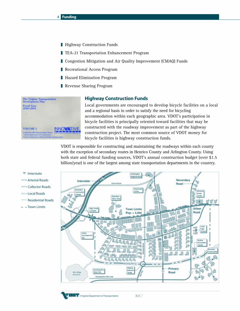
Funding4
4| Virginia Department of Transportation 4-
❚ Highway Construction Funds
❚ TEA-21 Transportation Enhancement Program
❚ Congestion Mitigation and Air Quality Improvement (CMAQ) Funds
❚ Recreational Access Program
❚ Hazard Elimination Program
❚ Revenue Sharing Program
Highway Construction FundsLocal governments are encouraged to develop bicycle facilities on a localand a regional basis in order to satisfy the need for bicyclingaccommodation within each geographic area. VDOT’s participation inbicycle facilities is principally oriented toward facilities that may beconstructed with the roadway improvement as part of the highwayconstruction project. The most common source of VDOT money forbicycle facilities is highway construction funds.
VDOT is responsible for constructing and maintaining the roadways within each countywith the exception of secondary routes in Henrico County and Arlington County. Usingboth state and federal funding sources, VDOT’s annual construction budget (over $1.5billion/year) is one of the largest among state transportation departments in the country.
Interstate
Arterial Roads
Collector Roads
Local Roads
Residential Roads
Town Limits

Funding 4
| Virginia Department of Transportation 54-
With this source, bicycle facilities are built in conjunction with the construction of newroadways and roadway improvements. Of course, the roadway improvement projectitself must first be in the Virginia Transportation Development Plan. Since the funding doesnot distinguish between the amount used for the roadway improvement and the amountused for the bicycle facility, it is not possible to estimate the amount of money allocatedspecifically to bicycle projects.
How roadway projects actually get onto the Virginia Transportation DevelopmentPlan can be somewhat confusing. Depending on the administrative system of theroadway (interstate, primary, secondary, or urban), the process is slightly different assummarized below.
All capital improvement projects are annually adopted by the CommonwealthTransportation Board as part of the Virginia Transportation Development Plan.
Getting the roadway project in the Virginia Transportation Development Plan is justthe first step towards constructing bicycle facilities with highway construction funds.In order for VDOT to consider using highway construction funds for the constructionof bicycle facilities, each of the following conditions must be met.

Funding4
6| Virginia Department of Transportation 4-
✔
✔
✔
✔
✔
✔
VDOT Participation Conditions
The bicycle facility is designed to meet current AASHTO and/or VDOT guidelinesThe bicycle facility is located or designed pursuant to a bicycle plan that has beenadopted by the local jurisdiction or MPO or is part of the Interstate Bicycle Route systemThe bicycle facility will have sufficient use in relation to cost to justify expenditureof public funds, or it is a significant link in a bicycle system that is needed for routecontinuityVDOT will initiate the construction of a bicycle facility only at the request of theaffected local government, with the exception of the Interstate Bicycle RoutesBicycle facility design plans must be coordinated with the affected local governmentand approved by VDOT prior to implementationConstruction of the bicycle facility must be concurrent with the highway construction
As evidenced by these conditions, it is important that localities take an active andproactive role in providing bicycle accommodation with roadway improvementprojects. VDOT will not construct bicycle facilities without the approval and supportof local governments. Perhaps the most important indication of that support is theexistence of a bicycle plan adopted by the local governing body.
TEA-21 Transportation Enhancement ProgramThe Transportation Enhancement Program is funded through the 1997Transportation Equity Act for the 21st Century, more commonly knownas TEA-21 (preceded by the Intermodal Surface Transportation EfficiencyAct of 1991). Unlike other federal discretionary funding programs(see Federal Highway Administration Section), this federal program isactually managed and administered by VDOT at the state level. Inorder to be eligible for funding, a project must meet certainrequirements including:
❚ a relationship to the surface transportation system
❚ qualifies under one of the Enhancement Program categories
❚ formally endorsed by a local jurisdiction or public agency as evidenced by aresolution and commitment of 20% minimum local match
❚ it must be endorsed by the MPO if within a Metropolitan Planning Organization(MPO) area
❚ a duly advertised public hearing must have been held on the project
Currently, there are twelve Transportation Enhancement Program categories eligiblefor funding, including “bicycle and pedestrian facilities” and “bicycle and pedestriansafety and educational activities.” Between 1993 and 2001, the Enhancement Programhas provided a total of over $104 million to all categories of projects across Virginia.
B E S T P R A C T I C E S 3 3

Funding 4
| Virginia Department of Transportation 74-
✔
✔
✔
✔
✔
✔
✔
✔
✔
✔
✔
✔
✔
Of that amount, approximately $59 million has been awarded to bicycle andpedestrian related projects. In order to be funded, a minimum 20% match is requiredin the form of money, labor, donations of land or materials, or a combination thereof.Historically, the match provided by Virginia project sponsors has far exceeded the 20%minimum. Approximately $124 million in local matches has been provided across thestate in the same time period from 1993 to 2001.
Bicycle and Pedestrian Facilities
Examples of types of projects eligible and not eligible for funding in the category ofBicycle and Pedestrian Facilities include:
Eligible Non-Eligible
Paved shoulders/wide outside lanes Maintenance activitiesBicycle paths Bicycle facilities that serve a recreationalBike lanes function onlyBicycle lockers and racks Widening of roadway to VDOT standards
Incidental element of new highwayproject to accommodate routine use(paved shoulders, wide curb lanes)
Bicycle and Pedestrian Safety and Educational Activities
Examples of types of projects eligible and not eligible for funding in this categoryinclude:
Eligible Non-Eligible
Development of educational materials Activities currently funded and providedSafety campaigns and programs by the community such as police bicycleSafety training patrols and school safety patrolsActivities related to safety enforcement
Who is Eligible?
Applicants for TEA-21 Transportation Enhancement money may include local governments,non-profit organizations, federal agencies, Planning District Commissions, stateagencies, and even private citizens. If a project is within VDOT right-of-way, VDOTmay administer the project and provide assistance if requested by the sponsor.Otherwise, the project may be administered directly by the applicant.
Application Process
Prior to completing an application, applicants need to obtain the required endorsementsfrom the locality, and the MPO as appropriate, and hold a public hearing. Conductedon an annual basis, the application process for this funding is shown on the following page.

Funding4
8| Virginia Department of Transportation 4-
Evaluation Criteria
Scoring criteria used to evaluate projects include:
❚ relationship to surface transportation
❚ inclusion in state, regional, or local plans
❚ demonstrable need and community improvement
❚ community support
❚ public accessibility
❚ compatibility with adjacent land use
❚ public/private venture
❚ environmental/air quality benefit
❚ aesthetic value
❚ impact on community economy and tourism
❚ educational impact
❚ safety impact
❚ originality and number of enhancement categories
❚ historic value
❚ strategy for maintenance
❚ relationship to previously funded project

Funding 4
| Virginia Department of Transportation 94-
Transportation Enhancement Program
Type: Annual competitive application process; reimbursable funds
Local Match: 20%; the federal share is 80% for selected projects
Due date: Applications due to VDOT by January 31
Contact: VDOT Enhancement Program: (800) 444-7832In Richmond area: (804) 786-2872 or (804) 786-2264
Website: www.VirginiaDOT.org
Example: Thomas Jefferson Memorial Parkway TrailAlbemarle County, Virginia: Awarded 1993
Congestion Mitigation and Air Quality Improvement ProgramCertain urbanized areas in Virginia are designated as being in non-attainment fornational air quality standards or in air quality maintenance areas: the Richmondmetropolitan area, Hampton Roads, and Northern Virginia. Localities within theseurban areas are eligible for funding through the Congestion Mitigation and Air QualityImprovement Program (CMAQ).
These federal funds, in the amount of approximately $37 million a year in Virginia,are available for a wide variety of projects aimed at reducing congestion andimproving air quality in those areas. To be funded, projects must be able todemonstrate an air quality benefit. Projects eligible for funding include theconstruction of bicycle facilities.
Who is Eligible?
Localities and regional entities within certain urban portions of the state are eligiblefor funding. In order to be eligible, an urban area must be designated as being“in non-attainment” or “in maintenance for attainment” in terms of meeting airquality standards.
Application Process
Each year, money is allocated to each Metropolitan Planning Organizations (MPO)within a non-attainment or maintenance urban area. The MPO then decides how todistribute the money among the various projects.

Funding4
10| Virginia Department of Transportation 4-
CMAQ Improvement Program
Type: Annual process, competitive within an MPO
Local Match: Urban: 0.4% Counties: No match required
Due date: Varies
Contact: VDOT Programming and Scheduling Division: (804) 786-2921
Website: www.VirginiaDOT.org
Example: Oyster Pointe Commercial Center bike path, Newport News
Note: May vary slightly by Metropolitan Planning Organization
Recreational Access ProgramThe Recreational Access Program is funded through an annual appropriation of up to$3 million from the state’s Transportation Trust Fund. The purpose of the program isto provide adequate access to public recreational facilities or historic sites operated bya state agency, a locality, or a local authority. Projects involving access to privateparks or recreational facilities operated by a federal agency are not eligible forfunding. “Access” can either be provided by an access road or a bicycle facility.Projects eligible for funding include the construction, reconstruction, maintenance, orimprovement of bikeways that provide access to such public areas. Activities noteligible for funding include the acquisition of right-of-way or utility adjustments.
The program is administered by VDOT’s Secondary Roads Division in conjunction withthe Virginia Department of Conservation and Recreation.
Who is Eligible?
Applications for Recreational Access Program funding may only be made by the governingbody of the county, city, or town in which the access road or bike facility is to be located.
Application Process
Prior to proceeding through the formal application process, several steps need to betaken by prospective applicants:
❚ If the recreational facility or historic site is not already established, prepare aplan for development and funding for the site. Adequate assurance must beprovided that the attraction will be operational at the approximate time theaccess facility is proposed for completion.
❚ Contact the Department of Conservation and Recreation to verify eligibility ofthe recreation facility or historic site to make sure it meets the funding criteria.
❚ Prepare the preliminary design of the access facility. Contact the appropriateResident Engineer for advice and assistance. A list of VDOT Residencies and phonenumbers is provided in the Appendix.

Funding 4
| Virginia Department of Transportation 114-
Once these items are completed, the formal application process, completed on ayear-round basis, is as shown below.
Funding Limitations
❚ State facilitiesUp to $75,000 may be awarded for bicycle facilities operated by a state agency.
❚ Local facilitiesUp to $60,000 may be awarded for bicycle facilities operated by a locality or localauthority. An additional $15,000 may be awarded if matched dollar for dollar by thelocality from other than highway sources.
Recreational Access Program
Type: Year-round competitive application process; reimbursable funds
Local Match: None; except as noted above in funding limitations
Due date: None; applications can be submitted anytime
Contact: VDOT Secondary Roads Division: (804) 786-2744
Website: www.VirginiaDOT.org
Example: Bikeway to Sherando Park, Frederick County

Funding4
12| Virginia Department of Transportation 4-
Hazard Elimination Safety ProgramThe Hazard Elimination Safety (HES) portion of the federal Highway Safety ImprovementProgram (HSIP) provides funding to improve areas where there are an abnormally highincidence of crashes, including railroad crossings. Many different types of safetyprojects are considered for the HES program, and projects often include installing turnlanes, traffic signals, or signs, and improving sight distance or roadway geometry.Given the increased concern with bicycle crashes and fatalities in Virginia, areas with bicyclinghazards are included in the list of eligible activities for this program. Since the focus ofthis program is related to safety, enhancement type projects are not appropriate for thistype of funding.
Potential locations are analyzed using a benefit-cost ratio (B/C) by comparing theanticipated reduction of crashes to the total cost of the project. A location must have a B/Cgreater than 1.0 to qualify for the HES program. Qualifying projects are ranked by B/Cfrom highest to lowest and funded until the federal allocation amount is reached. Due tothe limited amount of HES funds, not all the qualifying projects may receive funding. HESfunds are limited to $500,000 per project and projects costing more than $500,000 willbe considered only if they are jointly funded. Multiple improvements within a corridor mayqualify as one project if certain criteria are met. VDOT’s Traffic Engineering Division,administrator of the program, can provide program guidelines, application forms, andB/C calculation information.
Who is Eligible?
Applications for Hazard Elimination Safety Program funds may be submitted bylocalities and Planning District Commissions.
Application Process
❚ An application form can be obtained from VDOT’s Traffic Engineering Division.
❚ The application must be complete and should include detailed information on thelocation of the project and a description of the proposed improvement, the estimatedcost, and the number of bicycle crashes. Crash data can be obtained from VDOT orthe police. The last three complete years of crash data are used to analyze theapplications. Applicants submitting projects in cities and towns must submit crashdata in the form of police accident reports (FR-300).
❚ The application must be signed by an individual with the authority to expend thenecessary 10% matching funds.
❚ Applications for this funding may be submitted to VDOT between May 1 and June 30each year. Cities and towns should submit their applications to the State UrbanEngineer. All other applications must be submitted through the appropriateVDOT Residency or District office.
❚ For secondary road and urban projects, a local resolution is required uponnotification of program approval.

Funding 4
| Virginia Department of Transportation 134-
Hazard Elimination Safety Program
Type: Annual competitive application process; reimbursable funds
Local Match: 10%; the federal share is 90% for selected projects
Due date: Applications are due to VDOT by June 30 or sooner
Contact: VDOT Traffic Engineering Division: (804) 786-0132
Website: www.VirginiaDOT.org
Example: None
Revenue Sharing ProgramVDOT’s state funded Revenue Sharing Program provides additional funding toconstruct, improve, or maintain primary and secondary roadways within the countiesof the Commonwealth, including the former Nansemond County portion of the City ofSuffolk. Towns and cities that maintain their own roadway system are not eligible forthis program except as noted above for that portion of the City of Suffolk formerlydesignated as Nansemond County. Also not eligible are secondary road improvementsin Arlington and Henrico Counties. In 2000, $15 million in state funds was awardedthroughout the state. A maximum of $500,000 is available for each county. TheRevenue Sharing Program requires a 1:1 match from the locality, and this match mustcome from the county’s General Fund.
Projects eligible for funding through this program include:
❚ deficits on completed construction or improvements
❚ supplemental funding for ongoing construction or improvements
❚ supplemental funding for future construction or improvements listed in the adoptedVirginia Transportation Development Plan
❚ construction or improvements not included in the adopted Virginia TransportationDevelopment Plan
❚ unprogrammed maintenance whose accomplishment is consistent with theDepartment’s operating policies
Bicycle facilities are most often funded through the Revenue Sharing Program as partof a roadway widening project not included in the Virginia TransportationDevelopment Plan.
Who is Eligible?
Applications for Revenue Sharing funding may only be submitted by the governingbody of counties or the City of Suffolk for projects within the area formerly designatedas Nansemond County.

Funding4
14| Virginia Department of Transportation 4-
Application Process
❚ In January or February of each year, VDOT’s Secondary Roads Engineer sends aninvitation letter to all county governments to participate in the program.
❚ Interested counties prepare a prioritized plan requesting funds for eligible projectsand submit to the appropriate VDOT Resident Engineer.
❚ The Resident Engineer submits prioritized plan to the VDOT Secondary Roads Division.
❚ The Secondary Roads Division reviews plans and notifies the Resident Engineer ofthe amount of state matching funds available for use.
❚ VDOT develops a statewide plan based on acceptable individual county plans andsubmits it to the Commonwealth Transportation Board for approval.
Revenue Sharing Program
Type: Annual competitive application process
Local Match: 50%; the state share is 50% for selected projects
Due date: Varies per year; due date noted on invitation letter
Contact: VDOT Secondary Roads Division: (804) 786-6663
Website: www.VirginiaDOT.org
Example: Airport Road widening and bike lanes, Albemarle County, Virginia
Federal Highway Administration
Under the umbrella of the U.S. Department of Transportation, the Federal HighwayAdministration (FHWA) administers a variety of programs with money available forbicycle related projects. Perhaps the best known federal program often used for bicycleprojects is the TEA-21 Enhancement Program. In Virginia, the Enhancement Program isadministered by the Virginia Department of Transportation (VDOT) and is discussed in theVDOT section of this chapter. Three other federal programs are described below. Each oneis part of FHWA’s overall discretionary funds program which distributes money over twelvecategories including the three noted below. For all three programs, FHWA manages andadministers the funding process. In two cases VDOT acts as a clearinghouse for FHWA.
TEA-21 Scenic Byways ProgramUnder the Scenic Byways Program, the Federal Highway Administration recognizes the value ofnational and state designated scenic byways, roads with special scenic, historic, recreational,cultural, archaeological and/or natural qualities. In Virginia, designated scenic byways arereferred to as Virginia Byways and marked with the familiar blue sign with a red cardinal
BEST PRACTICES 34

Funding 4
| Virginia Department of Transportation 154-
and dogwood blossoms. Discretionary funding is available for a variety of categories related toscenic byways including the construction of facilities along a scenic byway for the use ofbicyclists and pedestrians. Approximately $25 million a year is available through thisgrant program for scenic byway projects nationwide through federal fiscal year 2003.Virginia has approximately $400,000 available each fiscal year through FY 2003.
Who is Eligible?
Eligible applicants include local governments, state agencies, MPO’s, and PDC’s.
Application Process
❚ Applicants, including localities, must complete a specific application form.
❚ Applicants must submit their application to VDOT, which acts a central clearinghouse.
❚ VDOT then submits the applications to the Federal Highway Administration, whichreviews and selects the projects for funding.
Evaluation Criteria
Criteria used by FHWA when evaluating applications include:
❚ state and byway priorities
❚ project benefits
❚ timely expenditure of previously awarded scenic byway funds
❚ leveraging of private or other public funding
Scenic Byways Program
Type: Annual competitive application process; reimbursable funds
Local Match: 20%; the federal share is 80% for selected projects
Due date: Application to VDOT no later than June 15
Contact: VDOT Byway Coordinator: (804) 371-6820
Information: www.byways.org and www.fhwa.dot.gov/discretionary
Example: Route 5 Capital to Capital Bikeway: multiple grants awardedbetween 1993–1997
TEA-21 Public Lands Highways ProgramThe Public Lands Highways Program was originally established in 1930 with funds provided bythe General Fund of the U.S. Treasury. The program has continued with each transportation actsince then, currently the Transportation Equity Act for the 21st Century (TEA-21). Approximately$65–$70 million is available from the Public Lands Highways Program for candidateprojects nationwide for each federal fiscal year through 2003. The intent of the program is

Funding4
16| Virginia Department of Transportation 4-
to improve access to and within the nation’s federal lands. Any type of transportationproject, including provision for pedestrians and bicycles, is eligible as long as it providesor improves access to federal lands that are also served by a public lands highway.
According to FHWA, “public lands highways” are defined as “a forest road under thejurisdiction of and maintained by a public authority and open to public travel or anyhighway through unappropriated or unreserved public lands, nontaxable Indian lands,or other Federal reservations under the jurisdiction of and maintained by a publicauthority and open to public travel.”
Who is Eligible?
Eligible applicants include localities, federal agencies, state agencies, and others.
Application Process
❚ Applicants must prepare a summary of the project (limited to two pages) thataddresses 16 specific items requested by FHWA.
❚ Applicants must submit their application (the two-page summary) to VDOT, whichacts a central clearinghouse.
❚ VDOT then submits the applications to the Federal Highway Administration, whichreviews and selects the projects for funding.
Evaluation Criteria
Criteria used by FHWA when evaluating applications include:
❚ equitable distribution of funding among states — preference is given to those states“behind” in their fair share of the funding
❚ leveraging of private or other public funding — the commitment of other fundingsources is viewed very favorably
❚ expeditious completion of project — preference given to the completion of viable projectsover requests for initial funding of projects dependent on future commitment offunding, and preference is given to construction projects over planning or design projects
❚ amount of money requested — for states with a relatively small amount of federallands, moderately sized project requests (< $500,000) are viewed more favorablythan requests for large amounts of money
❚ state priorities — for states which submit more than one project, consideration isgiven to that state’s priorities
❚ special federal public lands transportation needs — consideration of special orunique needs that merit additional consideration or satisfy a particular emphasis area
❚ congressional direction or guidance — Congress often specifies that funding bedirected to particular projects

Funding 4
| Virginia Department of Transportation 174-
Public Lands Highway Program
Type: Annual competitive application process; reimbursable funds
Local Match: None; the federal share is 100% for selected projects
Due date: Application to VDOT by mid-June
Contact: VDOT Secondary Roads Division: (804)786-2744
Website: www.fhwa.dot.gov/discretionary
Example: Chincoteague National Wildlife Refuge/Assateague Islandimprovements including trail construction for bicycles (2000)
TEA-21 Transportation and Community System Preservation Pilot ProgramIntroduced in 1998, the Transportation and Community and System Preservation (TCSP)pilot program was designed to encourage governments to integrate transportation serviceswith community needs such as community development, environmental protection,preservation of green space, and access to jobs and services. Consistent with livablecommunities concepts, it is designed to encourage activities that meet the following goals:
❚ improve the efficiency of the transportation system
❚ reduce the impact of transportation on the environment
❚ reduce the need for costly future infrastructure investments
❚ provide people with better access to jobs, services, and trade centers
❚ encourage private-sector development patterns that achieve these goals
While “bicycling” is not specifically mentioned, projects that provide bicycleaccommodation as part of overall community planning are certainly eligible for thistype of funding since they can help achieve many of these goals. Bicycle facilities mayalso be an integral component of a larger and multi-faceted proposal aimed at meetingthe above stated goals. The types of projects eligible for funding are broad and, unlikethe Transportation Enhancement Program, requirements are not specified. Activitieseligible for TCSP funding include:
Eligible Activities
those activities eligible for federal highway and transit fundingother activities determined by the U.S. Secretary of Transportation to be appropriate
Administered and managed by FHWA, the TCSP is a collaborative effort betweenFHWA and other federal agencies including the Federal Transit Administration and theU.S. Environmental Protection Agency. A total of $120 million is authorized for thisprogram for fiscal years 1999–2003.
✔
✔

Funding4
18| Virginia Department of Transportation 4-
Who is Eligible?
State agencies, local governments, and Metropolitan Planning Organizations.
Application Process
❚ Applicants must prepare a proposal that describes the project and addresses the fivegoals of the program described above.
❚ Proposals are sent directly to FHWA.
❚ FHWA reviews the proposals and selects the projects to be funded.
Evaluation Criteria
Criteria used when evaluating the proposals include:
❚ how well the project meets the above noted goals
❚ demonstrated commitment of non-federal resources with priority given to projectsthat leverage other sources of funding and take advantage of in-kind contributions
❚ effectiveness of the proposal’s project evaluation component that should includea description of activities to disseminate project results
❚ equitable distribution of grants with respect to a diversity of populations
❚ proposed involvement of non-traditional partners in the project team such as non-profitorganizations, health agencies, private land developers, environmental groups, etc.
A comprehensive discussion of this program and the application requirements can befound on FHWA’s TCSP web site noted below.
TCSP Pilot Program
Type: Annual competitive application process; reimbursable funds
Local Match: None; the federal share is 100% for selected projects
Due date: January 31 to FHWA in Richmond
Contact: FHWA Division Office: (804) 775-3320
Website: www.fhwa.dot.gov/tcsp/ and www.fhwa.dot.gov/discretionary
Example: Virginia Beach bike trail: grant awarded 2001

Funding 4
| Virginia Department of Transportation 194-
Virginia Department of Rail and Public Transportation
TEA-21 Transit Enhancement ProgramSimilar to the TEA-21 Transportation Enhancement Program, TEA-21 legislation alsoprovides money for enhancements to transit systems including the accommodation ofbicycles, bicycle access, and multi-modal connections. Projects typically fundedinclude the installation of bicycle storage facilities and the installation of equipmentfor transporting bicycles on mass transit vehicles.
Transit Enhancement Program
Type: Annual competitive application process; reimbursable funds
Local Match: 5%; the federal share is 95% for selected projects
Due date: Applications due to DRPT by January 31
Contact: Virginia Department of Rail and Public Transportation (DRPT):(804) 786-8135
Website: www.drpt.state.va.us
Example: Charlottesville Transit Service production of educational video“Buses and Bikes: Sharing the Road.”
State Aid Transit GrantsThe Virginia Department of Rail and Public Transportation also administers state aidgrant programs. Approximately $100 million in state grant money is available eachyear for transit systems including bicycle accommodation. A local match is required inorder to receive state transit grants. Although there is no minimum match requirement,a project with a 20% local match is more likely to receive funding than a project withonly a 5% match.
State Aid Transit Grants
Type: Annual competitive application process; reimbursable funds
Local Match: Varies per program
Due date: Applications due to DRPT by March 1 of each year
Contact: DRPT: (804) 786-8135
Website: www.drpt.state.va.us/business/grants/stateaid/stateaid.htm

Funding4
20| Virginia Department of Transportation 4-
Virginia Department of Conservation and Recreation
Virginia Recreational Trails FundFederally funded through TEA-21 using monies primarily from the Federal HighwayAdministration, the Virginia Recreation Trails Fund is administered in Virginia by theVirginia Department of Conservation and Recreation (DCR). Grant money through thisprogram is available for the purposes of providing and maintaining recreational trailsand trails-related facilities. While the emphasis of the TEA-21 TransportationEnhancement Program is on “transportation” projects, the focus of the RecreationalTrails Fund is “recreation.” In order to be eligible, a project must involve a trail ortrail-related facility that is open to the public. With significantly less money availablethrough this program, the focus is towards projects involving implementation andconstruction. It is important to note that planning activities for future trails or trailfacilities are not eligible, i.e. the development of a bicycle master plan. Eligibleactivities include, but are not limited to:
❚ development of urban trail linkages near homes and workplaces
❚ maintenance and restoration of existing recreational trails
❚ easement acquisition and development for trails/trail corridors in a state or local trail plan
❚ construction of new trails that meet identified needs on state, county, municipal, orprivate lands
❚ construction of new trails on federal lands if certain conditions are met
Approximately $1 million is available per year in Virginia through this highlycompetitive program. In order to spread the money as far as possible, projects ofsmaller scope typically have a greater chance of receiving funds. In previous years, theaverage award per project has been $55,000. As mandated by the federal guidelines,the pool of available money is split between projects involving motorized andnon-motorized trail use as follows:
❚ 30% of the program funds are for motorized recreational trail use
❚ 30% are for non-motorized recreational trail use
❚ 40% of the funds are for projects (either motorized or non-motorized use) with thegreatest number of compatible recreational purposes or that provide for innovativetrail corridor sharing
Who is Eligible?
Funding is available to private organizations, some city, town, and countygovernments, or other governmental entities. Federal government entities are eligible,and they are encouraged to team with private trail groups or organizations.

Funding 4
| Virginia Department of Transportation 214-
Application Process
❚ Applications are available from the Virginia Department of Conservation andRecreation.
❚ The deadline for submissions is January 31 of each year.
❚ Applications are reviewed by a DCR review committee for eligibility.
❚ Applications for eligible projects are reviewed and evaluated by the DCR TrailAdvisory Board for recommendation to the Department of Conservation andRecreation Board and the DCR director.
❚ Upon recommendation of the DCR Board, the DCR director selects projects andnotifies successful applicants.
Evaluation Criteria
Applications are reviewed on the following criteria:
❚ project need — linkages, unique characteristics, expected usage, in a plan
❚ project innovation — shared usage, design/maintenance, conservation, safety
❚ design parameters — incorporation of user needs, safety issues, environmental issues
❚ population served — demographics, user groups, compatibility
❚ support of project — community support/opposition, partnerships, funding support from others
❚ provisions for continuing existence — maintenance/operations, education, availability
Virginia Recreational Trails Fund
Type: Annual competitive application process; reimbursable funds
Local Match: 20%; the federal share is 80% for selected projects (as of 2001)
Due date: Applications due to DCR by January 31
Contact: Department of Conservation and Recreation: (804) 786-3218
Information: www.dcr.state.va.us
Example: Washington & Old Dominion Railroad Trail rehabilitation project inLeesburg, Virginia
Virginia Department of Motor Vehicles
Federal money from the National Highway Traffic Safety Administration (NHTSA) andthe Federal Highway Administration is used to fund the 402 Federal Highway Safety

Funding4
22| Virginia Department of Transportation 4-
Grant Program. In Virginia, the grant program is administered by the VirginiaDepartment of Motor Vehicles (DMV). The goal of this program is to provide moneyfor projects or programs designed to reduce crashes, injuries, and fatalities on ourhighways. A wide range of transportation safety related activities is eligible to receivefunding through this program including bicycle safety. While the total fundingavailable varies from year to year, approximately $4 million in grants was available toVirginia in 2000. The 402 Highway Safety money is actually distributed through twodifferent types of grant programs — an “annual grant” program and a “mini-grant”program, both described below.
402 Highway Safety Program — Annual GrantsThe 402 annual grants can be obtained through a competitive grant process. Overall,the diversity of eligible programs ranges from drunk driving prevention to motorcyclesafety and child safety seat/safety belt use. Bicycle and pedestrian safety is also aneligible program. Each application must identify a specific safety issue (i.e. bicyclesafety) and present a plan to address that issue. To be considered, proposals may addressefforts to start a new program or they may look at expanding an existing program.
Who is Eligible?
Entities eligible for funding include non-profit organizations, local governments andany sub-unit of local government, and state agencies.
Application Process
❚ For state agencies and non-profit organizations, applications are due May 31 eachyear to DMV headquarters in Richmond.
❚ For localities or sub-units of local government, applications are due April 14 eachyear to the appropriate DMV district’s transportation safety field representative.
❚ For applications submitted by localities, the district field representative reviews theproposals, prioritizes the applications, and forwards them to DMV headquarters.
❚ The Virginia Transportation Safety Board approves the final list of grant recipients.
❚ Successful projects are funded for a one-year duration.
Evaluation Criteria
According to the DMV guidelines for submission of applications, proposals that meetthe following criterion receive more favorable consideration than those that do not:
❚ precise definition of the safety problem
❚ clearly stated project or program objectives that are measurable and relate directlyto the identified safety problem
❚ description of the proposed solution in sequential time frames, includingperformance indicators and cost

Funding 4
| Virginia Department of Transportation 234-
❚ a cost assumption plan that addresses funding and support after the 402 funds areexhausted
❚ description of how the proposed project fits into the applicant’s total highwaysafety problem
❚ the ability to evaluate effectiveness of the project or program includingdocumentation of results and achievements
Projects or programs that are innovative, with the potential for statewide or multi-jurisdictional application receive special attention during the review process. Also,projects that identify and seek to solve safety problems within “high emphasiscommunities” (areas with high crash incidents) also receive special attention.
402 Highway Safety Program — Annual Grants
Type: Annual competitive application process; reimbursable funds
Local Match: None
Due date: Applications are due to DMV district by April 14 for localities orother sub-units of government; applications are due to DMVheadquarters by May 31 for state agencies and non-profitorganizations
Contact: Department of Motor Vehicles Headquarters: (804) 367-1143Bristol District: (540) 228-8698Roanoke District: (540) 561-7408Staunton District: (540) 801-0374Fairfax District: (703) 313-9443Richmond District: (804) 378-3425Portsmouth District: (757) 416-1742
Website: www.DMVNOW.com
Example: Safe Routes to School Program in Norfolk, Virginia
402 Highway Safety Program — Mini GrantsDepartment of Motor Vehicle safety field representatives administer the 402 mini-grantprogram. Unlike the annual grant program, monies available through this program areavailable throughout the entire year while funds last. This enables localities and othersto react to safety issues that may suddenly arise in their communities. Funds areavailable for a wide variety of safety programs including bicycle safety and education.Each year, approximately $35,000 is awarded across the state specifically for bicycleand pedestrian programs. This grant program does have a maximum allowable amountper grant of $1,500.
BEST PRACTICES 35

Funding4
24| Virginia Department of Transportation 4-
Who is Eligible?
Entities eligible for funding include non-profit organizations, local governments andany sub-unit of local government, and state agencies.
Application Process
❚ Applications can be turned in any time of the year to the appropriate district DMV office
❚ DMV district transportation safety field representatives review the proposals,determine if the proposed program meets funding requirements, and evaluate theproposal’s potential effectiveness in addressing the local safety issue
Funding Limitation
Localities and organizations can apply for mini-grants grants of up to $1,500.
402 Highway Safety Program — Mini Grants
Type: Year-round application process; reimbursable funds
Local Match: None
Due date: None; applications can be submitted anytime
Contact: Bristol District: (540) 228-8698Roanoke District: (540) 561-7408Staunton District: (540) 801-0374Fairfax District: (703) 313-9443Richmond District: (804) 378-3425Portsmouth District: (757) 416-1742
Website: www.DMVNOW.com
Example: Richland’s Police Department bicycle education program toencourage children in rural southwest Virginia to wear helmets
Virginia Tourism Corporation
Bicycling and bicycling events are popular activities in Virginia, a fact that theVirginia Tourism Corporation (VTC) seeks to advertise and promote for tourismpurposes. Two sources of funding, briefly described below, are available through theVirginia Tourism Corporation to assist others in their tourism-related marketing efforts.
Cooperative Marketing FundEstablished by the General Assembly in 1994, the Cooperative Marketing Program providesstate funds for the purpose of promoting, marketing, and advertising Virginia’s tourism

Funding 4
| Virginia Department of Transportation 254-
✔
✔
✔
✔
✔
✔
✔
✔
opportunities. For the 2000-2001 fiscal year, the program was funded at $6 million.This fund is available for joint advertising between the VTC and others to share the cost ofproducing promotional materials. Under these arrangements, the travel attributes of Virginiaand the co-sponsor are presented in one advertisement, thus leveraging the advertisingmoney available in the Corporation’s budget. Co-sponsor’s for such funding may be awide variety of private and public entities including localities and state agencies.
Cooperative Marketing Fund EligibilityEligible Non-Eligible
Print media — newspapers, magazines, Administrative expenses — salaries,and directories rent, phone, etc.Broadcast media — radio and news spots Equipment purchase or rentalPrinted materials — brochures, visitorguides, etc.Information technology — developmentof web sitesTravel trade shows — booth space rentalFamiliarization tours
Who is Eligible?
Numerous public and private entities, either individually or in partnerships with each other.
Application Process
❚ Applicants must submit a Letter of Intent to VTC by August 31 of each year. Thisletter must include a brief description of the proposed program, a list of partners inthe program, and an estimate of funding to be provided by the partners.
❚ Applicants (at least one representative) must attend at least one of the three pre-application meetings conducted by VTC during September and/or October of each year.
❚ Final applications, including marketing plans, financial information, time-lines, etc.are due to VTC on the date specified by VTC for each year. In 2001, applicationswere due on February 5.
❚ VTC staff reviews all complete applications and submits a summary to the TourismDevelopment Committee of the VTC Board of Directors.

Funding4
26| Virginia Department of Transportation 4-
Cooperative Marketing Fund
Type: Annual competitive application process
Local Match: 50%; the state share is 50% for selected projects
Due date: Varies each year
Contact: Virginia Tourism Corporation: (804) 371-0048
Information: www.vatc.org Select “Tourism Development”
Matching Grants Marketing ProgramVTC’s Matching Grants Marketing program was created by the Virginia GeneralAssembly in 1997 to stimulate and create tourism marketing and provide assistance tosmall tourism programs. In 2001, this program was funded at $200,000 for projectsacross the state with a cap of $5,000 available per application. Money is awardedthrough a competitive grant application process that occurs two times during the year.All applications must be for future projects; programs underway prior to the fundingperiod will not be considered. A clear plan to measure the effectiveness of theproposed marketing campaign, also referred to as a Performance Measurement Plan,must be included with the application.
Who is Eligible?
At least three entities, (a lead applicant and two supporting partners) must join toapply for grant consideration. Eligible entities include towns, cities, chambers ofcommerce, private businesses, museums, visitors bureaus, etc.
Application Process
❚ Applicants must submit a detailed application available from the VTC by the datespecified for each grant cycle.
❚ Applications are reviewed by VTC staff and are awarded based on evaluationcriteria.
Matching Grants Marketing Program
Type: Competitive application process that occurs twice a year
Local Match: 50%; the state share is 50% up to a maximum of $5,000 forselected projects
Due date: Varies each year
Contact: Virginia Tourism Corporation: (804) 371-0048
Website: www.vatc.org

BEST PRACTICES 32
F U N D I N G
Blacksburg Round-Up for Bikeways
The Town of Blacksburg is located in
western Virginia and is the home of
Virginia Tech. Blacksburg has a very active
bicycle program and has approximately
15 miles of bicycle network connecting most
of Blacksburg with trails in neighborhoods,
on campus, and in commercial areas.
Initiated in 1992, the “Round-up for
Bikeways” program is a unique method of
funding bicycle programs in Blacksburg.
The citizens of Blacksburg are given the
option on their utility bills to contribute to a
dedicated bicycle fund by simply “rounding
up” their water bill to the next whole dollar
or five dollar increment. Customers who
participate in the town’s automatic direct
debit payment method (money deducted
directly from their bank account) can also
contribute a fixed sum every billing period as
specified on their enrollment form. This is a
voluntary program that generates between
$2,000 to $4,000 per year.
The purpose of the program is to promote,
enhance, and/or build new bike lanes and
trails. Money generated by the program
has been used to support a bicycling
safety and education program, promote
Bike-to-Work day, and produce educational
materials in support of bicycling in the
contact
Town of Blacksburg
Planning and Engineering
300 South Main Street
Blacksburg, VA 24062
540.961.1183
town. A greenway brochure is currently
under development that will feature trails
throughout Blacksburg. In addition, the
town is producing a bicycle etiquette and
safety brochure for distribution to local
trail users and advocates.
Innovative Local Funding

BEST PRACTICES 33
Transportation Enhancement Funds
F U N D I N G
Park Boulevard Pedestrian andBicycle Path — Town of Marion
contact
MRPDC
1021 Terrace Drive
Marion, VA 24354
540.783.5103
The Town of
Marion’s Park
Boulevard Pedestrian
and Bicycle Path is
a good example of a small community’s
efforts to secure funds available through
the Transportation Enhancement Program
to build a key bicycle facility linking to
important activity centers. The Smyth
County Grassroots Conservancy and
Friends of Hungry Mother State Park
shaped the vision of the project to not only
include a bicycle facility, but restore the
landscape features of the original Civilian
Conservation Core (CCC) project in the
1930’s. Funding was obtained through a
competitive application process that recognized
the cooperative and collaborative effort
between local advocacy group members,
local and regional planners, state officials,
and others.
Located in Smyth County, the Town of
Marion is just south of Hungry Mother State
Park. The County Grassroots Conservancy,
Friends of Hungry Mother State Park, and
local and regional officials identified a need
for direct bicycle and pedestrian connection
to the park from the town’s downtown
area. This key connection to Hungry Mother
State Park, a regular stop for touring
bicyclists, will provide easy access to the
town proper for residents and visitors alike.
It was recommended that an off-road
facility be constructed to meet this need.
Working with the community, local
planners and the Mount Rogers Planning
District Commission applied for and received
Transportation Enhancement funding for
the design of the path to make this critical
connection for bicyclists.

BEST PRACTICES 34
F U N D I N G
Route 5 Capital to Capital Bikeway
A Virginia Byway
is a roadway with
high aesthetic
and/or cultural
value that leads to or is within an area of
historical, natural, or recreational significance.
Roughly 1,500 miles of roadways have been
designated as Virginia Byways and are
marked by the familiar byway sign depicting
a cardinal and dogwood blossoms on a
deep blue background.
To assist people across the country in planning,
preserving, promoting, and managing scenic
byways, the Federal Highway Administration
(FHWA) administers the National Scenic
Byways Program through the Transportation
Equity Act for the 21st Century (TEA 21).
Between 1992 and 2001, the National Scenic
Byways Program has funded almost $6 million
in scenic byways projects in Virginia through a
competitive grant program. One of the many
categories of projects eligible for this type
of funding is the construction of bicycle
facilities. In order to be considered for funding,
the project must be along a National
Scenic Byway, an All-American Road, or a
state designated byway (a Virginia Byway).
One bikeway project that has been particularly
successful in obtaining National Scenic
contact
Virginia Department of
Transportation
Environmental Division
1401 E. Broad Street
Richmond, VA 23112
804.371.6749
National Scenic Byways Program
Byways Program funding is the 50-mile
Route 5 Capital to Capital Bikeway
planned along scenic Route 5. The two-lane
primary roadway links Virginia’s modern
capital, Richmond, to her colonial capital,
Williamsburg. Currently in the planning and
design phases (all funded by the Scenic
Byways Program), a bikeway along this route
will offer superb bicycling opportunities
for those seeking a unique Virginia experience.

BEST PRACTICES 35
Richmond Braves Bicycle Helmet Giveaway/Sport Night
The Virginia
Department of
Health, through
its Center of
Injury and Violence
Prevention Division, sponsored a “Bicycle
Helmet Giveaway/Sport Night“ at the
Diamond baseball stadium in conjunction
with a Richmond Braves AAA baseball
game on June 2, 2000. The evening was
organized to highlight the importance of
bicycle safety through helmet use and an
understanding of the “rules of the road”
for child bicyclists. The evening was a
great success. The first 500 children ages
12 and under received a free bicycle
helmet and a $25 bicycle coupon. Free
game tickets were also awarded to thirty
children’s groups based on the level of
participation in an earlier art safety contest.
In addition, a drawing was held for 25 free
VIP box seat tickets. Finally, the VIP Superbox
was available for all groups that sent in
ten entries to the art safety contest. This
program highlights the ability of Virginia
state agencies to leverage funding from
each other for bicycling education,
encouragement, and injury prevention.
The event was funded by a 402 Federal
Highway Safety Mini-grant administered by
the Virginia Department of Motor Vehicles.
contact
Virginia
Department of Health
P.O. Box 2448
Richmond, VA 23218
804.371.2434
Helmet Give-Away
F U N D I N G

Appendix 5
| Virginia Department of Transportation 15-
Bristol District Phone: 540.669.6151
Residency Phone Number Counties Within Residency
Abingdon 540.676.5503 Smyth, Washington
Jonesville 540.346.1911 Lee, Scott
Lebanon 540.889.7600 Buchanan, Russell
Tazewell 540.988.2566 Bland, Tazewell
Wise 540.328.9331 Dickenson, Wise
Wytheville 540.228.2153 Grayson, Wythe
Culpeper District Phone: 540.829.7500
Residency Phone Number Counties Within Residency
Charlottesville 434.293.0011 Albemarle, Greene
Culpeper 540.829.7620 Culpeper, Madison, Orange
Louisa 540.967.3710 Fluvanna, Louisa
Warrenton 540.347.6441 Fauquier, Rappahannock
Fredericksburg District Phone: 540.899.4288
Residency Phone Number Counties Within Residency
Bowling Green 804.633.5091 Caroline, Essex, King William
Fredericksburg 540.899.4300 King George, Spotsylvania, Stafford
Saluda 804.758.2321 Gloucester, King and Queen,Mathews, Middlesex
Warsaw 804.333.3696 Lancaster, Northumberland,Richmond, Westmoreland
VDOT Districts and Residencies

Appendix5
2| Virginia Department of Transportation 5-
Hampton Roads District Phone: 757.925.2500
Residency Phone Number Counties Within Residency
Accomac 757.787.5810 Accomack, Northampton
Franklin 757.562.3194 Greensville, Southampton
Norfolk 757.494.2451 Chesapeake, Norfolk, Virginia Beach
Suffolk 757.925.2274 Isle of Wight, Suffolk
Waverly 804.834.3994 Surry, Sussex
Williamsburg 757.253.4832 James City, Hampton, Newport News,Poquoson, Williamsburg, York
Lynchburg District Phone: 434.947.6559
Residency Phone Number Counties Within Residency
Amherst 434.946.7631 Amherst, Nelson
Appomattox 434.352.7135 Appomattox, Campbell
Chatham 434.432.7214 Pittsylvania
Dillwyn 434.983.2017 Buckingham, Cumberland, Prince Edward
Halifax 434.476.6342 Charlotte, Halifax
Northern Virginia District Phone: 703.383.8368
Residency Phone Number Counties Within Residency
Fairfax 703.383.8368 Arlington, Fairfax
Leesburg 703.737.2000 Loudoun
Manassas 703.366.1900 Prince William
Richmond District Phone: 804.524.6000
Residency Phone Number Counties Within Residency
Amelia 804.561.2411 Amelia, Lunenburg, Nottoway
Ashland 804.752.5511 Goochland, Hanover
Chesterfield 804.674.2800 Chesterfield, Powhatan
Petersburg 804.863.4000 Dinwiddie, Prince George
Sandston 804.328.3044 Charles City, Henrico, New Kent
South Hill 434.774.2300 Brunswick, Mecklenburg

Appendix 5
| Virginia Department of Transportation 35-
Salem District Phone: 540.387.5320
Residency Phone Number Counties Within Residency
Bedford 540.586.7910 Bedford
Christiansburg 540.381.7200 Giles, Montgomery, Pulaski
Hillsville 540.728.2813 Carroll, Floyd
Martinsville 540.629.2581 Henry, Patrick
Rocky Mount 540.483.5262 Franklin
Salem 540.387.5488 Botetourt, Craig, Roanoke
Staunton District Phone: 540.332.9075
Residency Phone Number Counties Within Residency
Edinburg 540.984.5600 Frederick, Shenandoah
Harrisonburg 540.434.2586 Rockingham
Lexington 540.463.3108 Alleghany, Bath, Rockbridge
Luray 540.743.6585 Clarke, Page, Warren
Verona 540.332.8991 Augusta, Highland

Appendix 5
| Virginia Department of Transportation 55-
Virginia State Agency Publications
Planning and Design
Connecting our Commonwealth — The Virginia Greenways and Trails Toolbox,Virginia Department of Conservation and Recreation.
Road Design Manual, Virginia Department of Transportation.
Education, Encouragement, Enforcement
2001/2002 Virginia Bicycle Guide, Virginia Department of Transportation and VirginiaTourism Corporation.
Bike Smart! Virginia, Virginia Department of Health.
Bicycling on Virginia Roads — Laws and Safety Tips, Virginia Department ofTransportation.
A Map of Scenic Roads in Virginia, Virginia Department of Transportation.
Put a Lid On It — Wear a Helmet, Videotape by the Virginia Department of Health.
Traffic Crash Facts, Virginia Department of Motor Vehicles, Annual.
FundingGuide to the Recreational Access Program of the Virginia Department ofTransportation, Virginia Department of Transportation.
Virginia Recreational Trails Fund Program, Department of Conservation andRecreation, Annual.
Transportation Enhancement Program — Application Guide, Virginia Department ofTransportation, Annual.
Transportation Enhancement Program — Guide Pamphlet, Virginia Department ofTransportation, Annual.
Transportation Enhancement Program — Procedural Manual, Virginia Departmentof Transportation, Annual.
Resource Publications

Appendix5
6| Virginia Department of Transportation 5-
Studies
Economic Benefits of Bicycle Trails and Events in Virginia, Virginia Department ofTransportation, June 2000.
Inventory Study of Interstate Bicycle Routes 1 and 76, Virginia Department ofTransportation, June 1999.
Route 5 Capital to Capital Bikeway Feasibility Study, Virginia Department ofTransportation, May 1999.
National Publications
Planning and Design
Bicycle and Pedestrian Data: Sources, Needs & Gaps, U.S. Department ofTransportation, 2000.
The Bicycle Compatibility Index: A Level of Service Concept, ImplementationManual, Federal Highway Administration, Publication No. FHWA-RD-98-095,1998.
Bicycle Lanes Versus Wide Curb Lanes: Operational and Safety Finding andCountermeasure Recommendations, Federal Highway Administration (FHWA),Publication No. FHWA-RD-99-035, 1999.
A Comparative Analysis of Bicycle Lanes Versus Wide Curb Lanes: Final Report,Federal Highway Administration (FHWA), Publication No. FHWA-RD-99-034, 1999.
Conflicts on Multiple-Use Trails: Synthesis of the Literature and State of thePractice, Federal Highway Administration (FHWA), Publication No. FHWA-PD-94-031, 1994.
Design Guidance – Accommodating Bicycle and Pedestrian Travel: ARecommended Approach, U.S. Department of Transportation, 2000.
Designing Sidewalks and Trails for Access: Part I of II: Review of Existing Guidelinesand Practices, Federal Highway Administration (FHWA), Publication No. FWHA-HEP-99-006.
Designing Sidewalks and Trails for Access: Part II of II: Best Practices Design Guide,Federal Highway Administration (FHWA), Publication No. FHWA-EP-01-027.
The Effects of Bicycle Accommodations on Bicycle Motor Vehicle Safety and TrafficOperations, Federal Highway Administration (FHWA), Publication No. FHWA - RD-92-069,1994.
Flexibility in Highway Design, Federal Highway Administration (FHWA), Publication No.FHWA-PD-97-062.
Guide for the Development of Bicycle Facilities, American Association of StateHighway and Transportation Officials (AASHTO), 1999.
Appendix 5
| Virginia Department of Transportation 75-
Guidebook on Methods to Estimate Non-Motorized Travel, Federal HighwayAdministration, Publication No. FHWA-RD-98-165, 1999.
Guidebook on Methods to Estimate Non-Motorized Travel: SupportingDocumentation, Federal Highway Administration, Publication No. FHWA-RD-98-166, 1999.
Implementing Bicycle Improvements at the Local Level, Institute of Traffic Engineers(ITE), 1999.
Implementing Bicycle Improvements at the Local Level, Federal HighwayAdministration (FHWA), Publication No. FHWA-RD-98-105, 1998.
Improving Conditions for Bicycling and Walking — A Best Practices Report, FederalHighway Administration (FHWA), January 1998.
Manual on Uniform Traffic Control Devices, U.S. Department of Transportation, 2000.
A Policy on Geometric Design of Highway and Streets, American Association of StateHighway and Transportation Officials, 1990.
Rails-With-Trails: Sharing Corridors for Recreation and Transportation, Brilliot,Michael and Julie A. Winterich, Rails to Trails Conservation, 1993.
Selecting Roadway Design Treatments to Accommodate Bicycles, Federal HighwayAdministration (FHWA), Publication No. FHWA-RD-92-073, 1994.
Technical Brief: Maintenance of Bicycling and Pedestrian Facilities, National Bicycleand Pedestrian Clearinghouse, 1995.
FHWA National Bicycling and Pedestrian Reports
Final Report: The National Bicycling and Walking Study, Transportation Choices fora Changing America, Federal Highway Administration (FHWA), Publication No. FHWA-PD-94-023, 1994.
Reasons Why Bicycling and Walking are Not Being Used More, Federal HighwayAdministration (FHWA), National Bicycling and Walking Study, Case Study #1, PublicationNo. FHWA-PD-92-041.
The Training Needs for Professionals, Federal Highway Administration (FHWA),National Bicycling and Walking Study, Case Study #2, Publication No. FHWA-PD-92-038.
What Needs to be Done to Promote Bicycling and Walking, Federal HighwayAdministration (FHWA), National Bicycling and Walking Study, Case Study #3, PublicationNo. FHWA-PD-93-039.
Measures to Overcome Impediments to Bicycling and Walking, Federal HighwayAdministration (FHWA), National Bicycling and Walking Study, Case Study #4, PublicationNo. FHWA-PD-93-031.

Appendix5
8| Virginia Department of Transportation 5-
An Analysis of Current Funding Mechanisms, Federal Highway Administration (FHWA),National Bicycling and Walking Study, Case Study #5, Publication No. FHWA-PD-93-008.
Analysis of Successful Grass-Roots Movements, Federal Highway Administration(FHWA), National Bicycling and Walking Study, Case Study #6, Publication No. FHWA-PD-93-024.
Transportation Potential and Other Benefits of Off-Road Bicycle and PedestrianFacilities, Federal Highway Administration (FHWA), National Bicycling and Walking Study,Case Study #7, Publication No. FHWA-PD-92-040.
Organizing Citizens Support and Acquiring Funding, Federal HighwayAdministration (FHWA), National Bicycling and Walking Study, Case Study #8, PublicationNo. FHWA-PD-93-007.
Linking Bicycle/Pedestrian Facilities with Transit, Federal Highway Administration(FHWA), National Bicycling and Walking Study, Case Study #9, Publication No. FHWA-PD-93-012.
Trading Off Among the Needs of Motor Vehicle Users, Pedestrians, Bikes, FederalHighway Administration (FHWA), National Bicycling and Walking Study, Case Study #10,Publication No. FHWA-PD-94-012.
Balancing Engineering, Education, Law Enforcement and Encouragement, FederalHighway Administration (FHWA), National Bicycling and Walking Study, Case Study #11,Publication No. FHWA-PD-93-09.
Incorporating Consideration of Bicyclists & Pedestrians into Education, FederalHighway Administration (FHWA), National Bicycling and Walking Study, Case Study #12,Publication No. FHWA-PD-92-06.
A Synthesis of Existing Bicyclist and Pedestrian Related Laws and EnforcementPrograms, Federal Highway Administration (FHWA), National Bicycling and WalkingStudy, Case Study #13, Publication No. FHWA-PD-93-018.
Benefits of Bicycling and Walking to Health, Federal Highway Administration (FHWA),National Bicycling and Walking Study, Case Study #14, Publication No. FHWA-PD-93-025.
The Environmental Benefits of Bicycling and Walking, Federal HighwayAdministration (FHWA), National Bicycling and Walking Study, Case Study #15,Publication No. FHWA-PD-93-015.
A Study of Bicycle and Pedestrian Programs in European, Federal HighwayAdministration (FHWA), National Bicycling and Walking Study, Case Study #16,Publication No. FHWA-PD-92-037.
Bicycle/Pedestrian Policies and Programs in Asia, Australia, New Zealand, FederalHighway Administration (FHWA), National Bicycling and Walking Study, Case Study #17,Publication No. FHWA-PD-93-016.

Appendix 5
| Virginia Department of Transportation 95-
Analyses of Successful Provincial, State, and Local Programs, Federal HighwayAdministration (FHWA), National Bicycling and Walking Study, Case Study #18,Publication No. FHWA-PD-93-010.
Traffic Calming, Auto-Restricted Zones and Other Traffic Management Techniques— Their Effects on Bicycling and Pedestrians, Federal Highway Administration (FHWA),National Bicycling and Walking Study, Case Study #19, Publication No. FHWA-PD-93-028.
The Effects of Environmental Design on the Amount and Type of Bicycling andWalking, Federal Highway Administration (FHWA), National Bicycling and Walking Study,Case Study #20, Publication No. FHWA-PD-93-037.
Incorporating Bicycle and Pedestrian Consideration Into State and LocalTransportation Planning, Design, and Operations, Federal Highway Administration(FHWA), National Bicycling and Walking Study, Case Study #21, Publication No. FHWA-PD-93-017.
The Role of State Bicycle/Pedestrian Coordinator, Federal Highway Administration(FHWA), National Bicycling and Walking Study, Case Study #22, Publication No. FHWA-PD-93-019.
Current Planning Guidelines and Design Standards Being Used By State and LocalAgencies for Bicycle and Pedestrian Facilities, Federal Highway Administration (FHWA),National Bicycling and Walking Study, Case Study #24, Publication No. FHWA-PD-93-006.
Education, Encouragement, Enforcement
Access 2000: Bicycle and Pedestrian Access to Rail Transit Stations in Maryland,Maryland Department of Transportation, 1997.
The Basics of Bicycling— A Curriculum for Elementary Level Bicyclists Training,Bicycle Federation of America, 1995.
Bicycle and Pedestrian Provisions of the Federal-Aid Program, U.S. Department ofTransportation, Publication # FHWA-PD-98-049, 1998.
Bicycling and Walking in Colorado — Economic Impact and Household SurveyResults, The Colorado Department of Transportation, April 2000.
Bicycling & Walking in the Nineties and Beyond: Applying ScandinavianExperience to America’s Challenge, Federal Highway Administration (FHWA), 1994.
Evaluation of the Burke-Gilman Trail’s Effect on Property Values and Crimes, City ofSeattle, Seattle Engineering Department, Office of Planning, Seattle Washington, 1987.
The Guide to Bicycle Rodeos, John Williams and Dan Burden, Outdoor EmpirePublishing Company, Inc., Third Edition, 1994.
The Impacts of Rail Trails, U.S. Department of the Interior, 1992.

Appendix5
10| Virginia Department of Transportation 5-
FHWA Study Tour for Pedestrian and Bicyclist Safety in England, Germany and theNetherlands, Federal Highway Administration (FHWA), 1994.
Rail-Trails and Safe Communities: The Experience of 372 Trails, Rails-to-TrailsConservancy, 1998.
Sourcebook for Federal, State, and Foundation Assistance, National Park Service, 1999.
Street Smarts — Bicycling’s Traffic Survival Guide, John Allen, 1995.
Trails for the 21st Century, Rails to Trails Conservancy, 1993.
Statewide Bicycle Plans Examples
Bicycle Facility Design Standards, City of Philadelphia Streets Department, 1998.
Idaho Bicycle and Pedestrian Transportation Plan, Idaho Transportation Department,January 1995.
Massachusetts Bicycle Transportation Plan, Massachusetts Highway Department, 1998.
North Carolina Bicycle Facilities Planning and Design Guidelines, North CarolinaDepartment of Transportation, 1994.
Oregon Bicycle and Pedestrian Plan, Oregon Department of Transportation, 1995.

Appendix 5
| Virginia Department of Transportation 115-
Resource Websites
Virginia
Agencies
Official Homepage of the Commonwealth of Virginia — The site maintains anelectronic gateway to public information, as well as assists Virginia government entitiesin providing information and services via the Internet.www.vipnet.org
Virginia Department of Conservation and Recreation — The website providesinformation on Virginia’s State Parks, recent greenways initiatives, and bicycling andbikeways standards.www.dcr.state.va.us
Virginia Department of Transportation Bicycle and Pedestrian Program — The websiteidentifies existing bicycling opportunities (events, trails, organizations, etc.) throughout thecommonwealth, defines bicycle laws and safety tips in support of safe bicycling in theCommonwealth, and acts as a clearing house for various bicycle information and products.www.VirginiaDOT.org
Organizations
BikeWalk Virginia — The site provides information and resources to promote responsibleand safe bicycling and walking for transportation, recreation, and health and fitness.www.bikewalkvirginia.org
Virginia Bicycling Federation (VBF) — The VBF is a bicycle advocacy group with thegoal to help build a bicycle-friendly Virginia by joining a statewide alliance of bicyclistsworking together to improve conditions on city streets, rural roads and off-road trails.www.vabike.org
National
Planning and Design
American Association of State Highway and Transportation Officials (AASHTO) —AASHTO is an advocate for multimodal and intermodal transportation and providesleadership, technical services, information and advice as well as contributing to nationalpolicy on transportation issues.www.aashto.org
Appendix5
12| Virginia Department of Transportation 5-
Association of Pedestrian and Bicycle Professionals — The Association ofPedestrian and Bicycle Professionals site promotes excellence in the emergingprofessional discipline of pedestrian and bicycle transportation and provides resourcesand information to leaders in the engineering, planning, landscape architecture,safety and promotion fields who specialize in improving conditions for bicyclingand walking.www.apbp.org
Federal Highway Administration (FHWA) — The site provides expertise, resources, andinformation to continually improve the quality of our nation’s highway system and itsintermodal connections.www.fhwa.dot.gov
Institute of Transportation Engineers (ITE) — The site provides information andresources for safe and efficient surface transportation through planning, designing,implementing, operating and maintaining surface transportation systems worldwide.www.ite.org/
Pedestrian and Bicycle Information Center (PBIC) — The site was established toprovide transportation engineers and planners, safety and health professionals, andadvocates, access to the best available information on improving conditions for bicyclingand walking in the United States.www.bicyclinginfo.org
Education, Encouragement, Enforcement
Adventure Cycling Association — The site promotes bicycling for exploration,discovery, and adventure and provides resources and information in support ofadvocacy and education for a bicycle-friendly America.www.adventurecycling.org
American Trails — The site provides trails and greenways information such as trail news,resources, contacts, advocacy, calendar of trail events, funding, legislation and links toother trails-oriented web sites for all trail users — including hiking, bicycling, mountainbiking, horseback riding, water trails, snowshoeing, cross-country skiing, trailmototcycling, ATVs, snowmobiling, and four wheeling.www.AmericanTrails.org
Bikes Belong Coalition — The Bikes Belong Coalition is a bicycle advocacy group withthe goal to put more people on bikes more often through the implementation of TEA-21.The websites primary focus is to assist local organizations, agencies, and citizens indeveloping bicycle facilities projects that will be funded by TEA-21. In addition, BikesBelong Coalition is the bicycle industry’s political lobbyist. www.bikesbelong.org

Appendix 5
| Virginia Department of Transportation 135-
Commuter Connections — The site provides information and resources to assistbusinesses and employees in the Washington metropolitan area with commuterservices.www.mwcog.org/commuter/ccindex.html
East Coast Greenways — The site provides information for walkers, cyclists, andother trail advocates in support of a 2,600 mile traffic-free path linking East Coastcities from Maine to Florida.www.greenway.org
Federal Highway Administration Bicycle and Pedestrian Program Office — The siteprovides information and resources for promoting bicycle and pedestrian transportationaccessibility, use, and safety.www.fhwa.dot.gov/environment/bikeped/
International Bicycle Fund — The International Bicycle Fund is a non-governmental,nonprofit organization, promoting sustainable transport and internationalunderstanding. Major areas of activity are non-motorized urban planning, economicdevelopment, bike safety education, responsible travel and cycle tourism, and cross-cultural, educational programs.www.ibike.org
League of American Bicyclists — The site promotes bicycling for fun, fitness andtransportation and provides resources and information in support of advocacy andeducation for a bicycle-friendly America.www.bikeleague.org
National Center for Bicycling and Walking — The site presents informationalresources and focuses on issues of public health, including physical activity promotion,chronic disease prevention and environmental health, as well as transportation, land use,and public safety and injury prevention.www.bikefed.org
National Highway Traffic Safety Administration Bicycle Safety Program — The sitehighlights education, enforcement, outreach and legislation towards reducing bicycleinjuries and fatalities. Some of the goals and programs include: increasing the use ofbicycle helmets, increasing awareness about sharing the road with cyclists and motorists,and promoting safe bicycle practices.www.nhtsa.dot.gov/people/injury/pedbimot/bike/index.htm
Trails and Greenways — The Trails and Greenways Clearinghouse provides technicalassistance, information resources and referrals to trail and greenway advocates anddevelopers across the nation. Services are free and available to individuals, governmentagencies, communities, grassroots organizations and anyone who is seeking to create ormanage trails and greenways.www.trailsandgreenways.org
Appendix5
14| Virginia Department of Transportation 5-
Funding
Transportation Equity Act for the 21st Century (TEA-21) — The site providesupdated information on TEA-21.www.tea21.org
National Scenic Byways Program — �The National Scenic Byways Program site isprovided by the U.S. Department of Transportation and provides information onAmerica’s Byways, funding opportunities, news releases and other information insupport of scenic byways.www.byways.org
FHWA Discretionary Programs — �This site presents FHWA special funding categoriesand provides information on various project categories, eligibility criteria, requiredapplication process, selection process, and on-going projects.www.fhwa.dot.gov/discretionary
Transportation and Community and System Preservation Pilot Program ��This siteprovides information on the Transportation and Community and System PreservationPilot Program. The program is sponsered by the U.S. Department of Transportation andprovides grants to states, local governments, and metropolitan planning organizations toinvestigate the relationships between transportation and community and systempreservation and private sector-based initiatives.www.fhwa.dot.gov/tcsp/

| Virginia Department of Transportation
Notes