V Circulation / Transportation A....
20
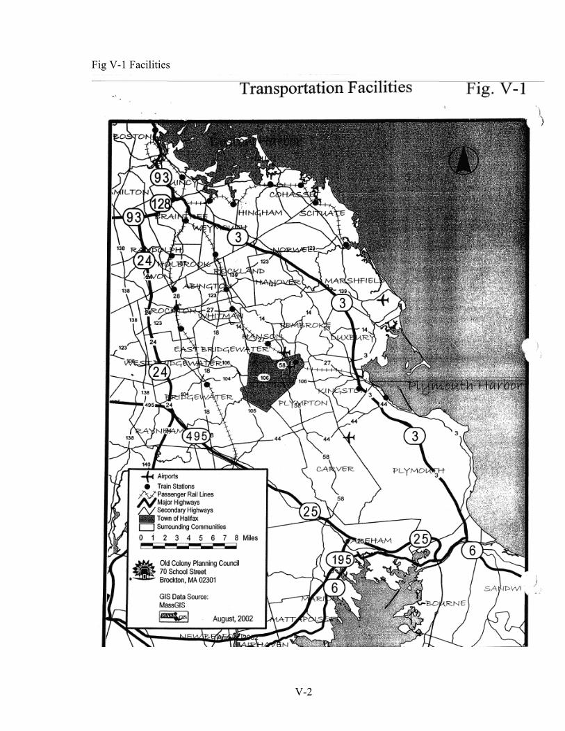
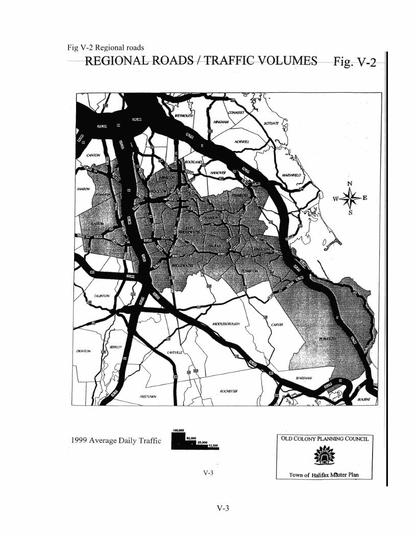
V-1 V Circulation / Transportation A. Background Halifax is in Southeastern Massachusetts, bordered by Bridgewater and East Bridgewater on the West, Middleboro on the South, Plympton on the East and Southeast, Pembroke on the Northeast, and Hanson on the North. It is 14 miles southeast of Rte. 24, 8 miles west of Rte. 3, and 27 miles by rail to Boston on the Plymouth line of the restored Old Colony Commuter rail system. With approximately 6000 acres of privately-owned vacant land it has much potential for development. Recent residential growth has been significant both in subdivisions and in approval-not- required lots, particularly along Thompson St. in the southeastern portion of the town. Major recent non-residential projects include a Wal-Mart store at the intersection of Rtes. 58 and 106 and the MBTA commuter rail station on Rte. 36 (Holmes St.) near the Pembroke line. Rail service was restored in the Fall of 1997 while the store opened in the Summer of 1998. The store draws on surrounding communities, thereby potentially attracting traffic to the town; the growing neighborhoods increase traffic within and through the town; and the station increases local traffic to the site, but reduces longer distance work trips. B. Structure The town is traversed by four numbered state routes. The major roads are Rte. 106 (Plymouth St.) which runs east-west from Kingston to Plainville, and Rte. 58 (Monponsett St.) running north and south from Weymouth to Rochester. It connects with the major east-west highway, Rte. 44, in Middleboro. In addition, Rte. 105 (Thompson St.) runs south from Rte. 106 to Lakeville. Finally the 3.2-mile Rte. 36 (Holmes St.) runs north from Rte. 106 in Halifax to Rte. 14 in Pembroke. This reputedly is the state’s shortest numbered route and was created to give friends of a former governor numbered routes all the way to South Shore recreational destinations. Halifax is less easily accessible than many towns, being 9-10 miles east of Rte. 24 and 7-8 miles west of Rte. 3, though only about 5 miles from the improved east-west Rte. 44 which connects with Rtes. 3, 24 and 495. On the other hand the town is right on the restored Old Colony commuter rail line, having a station on Holmes St. near the Pembroke line. This makes a Boston/Cambridge-oriented commute much easier than from towns which are limited to highway commuting. Figure V-2 shows the configuration and volumes of the town’s roads in the context of the regional highway network and Figure V-3 shows the town’s overall roadway system. Halifax’s circulation system is not as radial as in many towns. Rather it consists of a major east-west route (Rte. 106) connecting many north-south routes and local streets, most significantly Rte. 58, like ribs on a spine. There is a lesser, nearly discontinuous, east-west
Transcript of V Circulation / Transportation A....
V-1
V
Circulation / Transportation A. Background Halifax is in Southeastern Massachusetts, bordered by Bridgewater and East Bridgewater on the West, Middleboro on the South, Plympton on the East and Southeast, Pembroke on the Northeast, and Hanson on the North. It is 14 miles southeast of Rte. 24, 8 miles west of Rte. 3, and 27 miles by rail to Boston on the Plymouth line of the restored Old Colony Commuter rail system. With approximately 6000 acres of privately-owned vacant land it has much potential for development. Recent residential growth has been significant both in subdivisions and in approval-not-required lots, particularly along Thompson St. in the southeastern portion of the town. Major recent non-residential projects include a Wal-Mart store at the intersection of Rtes. 58 and 106 and the MBTA commuter rail station on Rte. 36 (Holmes St.) near the Pembroke line. Rail service was restored in the Fall of 1997 while the store opened in the Summer of 1998. The store draws on surrounding communities, thereby potentially attracting traffic to the town; the growing neighborhoods increase traffic within and through the town; and the station increases local traffic to the site, but reduces longer distance work trips. B. Structure The town is traversed by four numbered state routes. The major roads are Rte. 106 (Plymouth St.) which runs east-west from Kingston to Plainville, and Rte. 58 (Monponsett St.) running north and south from Weymouth to Rochester. It connects with the major east-west highway, Rte. 44, in Middleboro. In addition, Rte. 105 (Thompson St.) runs south from Rte. 106 to Lakeville. Finally the 3.2-mile Rte. 36 (Holmes St.) runs north from Rte. 106 in Halifax to Rte. 14 in Pembroke. This reputedly is the state’s shortest numbered route and was created to give friends of a former governor numbered routes all the way to South Shore recreational destinations. Halifax is less easily accessible than many towns, being 9-10 miles east of Rte. 24 and 7-8 miles west of Rte. 3, though only about 5 miles from the improved east-west Rte. 44 which connects with Rtes. 3, 24 and 495. On the other hand the town is right on the restored Old Colony commuter rail line, having a station on Holmes St. near the Pembroke line. This makes a Boston/Cambridge-oriented commute much easier than from towns which are limited to highway commuting. Figure V-2 shows the configuration and volumes of the town’s roads in the context of the regional highway network and Figure V-3 shows the town’s overall roadway system. Halifax’s circulation system is not as radial as in many towns. Rather it consists of a major east-west route (Rte. 106) connecting many north-south routes and local streets, most significantly Rte. 58, like ribs on a spine. There is a lesser, nearly discontinuous, east-west
V-2
Fig V-1 Facilities
V-3
Fig V-2 Regional roads

V-4
Fig V-3 Roadways
V-5
route (Walnut St./ Pratt St./River St./ Wood St./ and Cedar St.) in the southern end of town. There is no such route in the north, due to the Monponsett Ponds. The intersection of Rtes.58 and 106 is the busiest in town, being the junction of the two major routes at the town’s commercial center. It had the only traffic signal in town until a signal was added at the Wal*Mart entrance jus to the west. It also has the most accidents. The situation is becoming more complex with the recent addition of the Wal*Mart store with access points west and north of the intersection, and with a large grocery store planned just to the west. Halifax’s overall road system is becoming less flexible due to the development of large subdivisions with just one or two connections to the local road system. This gives privacy at the cost of isolation, and offers few alternative routes in case of emergencies. It increases traffic on the few through-roads and collectors, and requires round-about trips to many nearby destinations. It sometimes forces people to drive to destinations which could be walked or pedaled with a more complete system, that is, with fewer dead end roads, or with connecting pedestrian ways and bike ways. The town’s roads are generally two-lane minor arterials (classified as Rural Collectors by the Massachusetts Highway Department). They carry relatively low, but growing traffic volumes through sparsely developed areas at speeds higher than the posted limits of 35-45 mph. The roads are generally well-maintained, but some work is recommended as discussed below. Sidewalks have been added to some of the most important stretches, particularly along Rte. 106 from Cranberry Drive to Redwood St. in the Mobile Home Park, and on recently reconstructed portions of the southern end of Thompson St. The new sidewalks are well used and the Highway Surveyor’s policy is to add sidewalks whenever a major road is improved. Sidewalks to be added as part of the forthcoming resurfacing of Rte. 36 should ease pedestrian access to the T station. However there are few opportunities for pedestrian/ bicycle movement off of the roads or between developments. The desirability of increasing pedestrian / bicycle access ways between neighborhoods and from neighborhoods to other destinations is discussed below. C. Conditions Roads Pavement maintenance needs are partly indicated through Halifax’s participation in the Regional Pavement Management Program (PMP) administered by the Old Colony Planning Council. The program helps town and state decision makers to develop and implement cost-effective methods for maintaining pavement in a good serviceable condition. The system involves field checking pavement condition in great detail and entering the results in a data base for use with other information in defining and scheduling needed work.
The Massachusetts Highway Department and the Regional Planning Agency (OCPC) do field checking; OCPC evaluates the Federal Aid eligible roads; and the towns examine the more extensive local roads to the extent that resources allow.
V-6
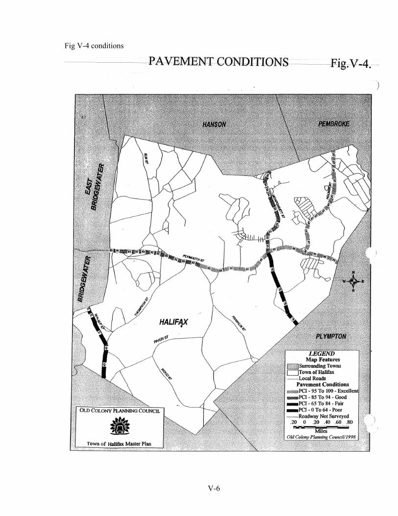
Fig V-4 conditions

V-7
Table V-1 Summary

V-8

V-9
Fig V-5 cost

V-10
Presently PMP data are being analyzed to develop strategies for effectively-timed road is derived through a synthesis of pavement distress factors (e.g., pot holes, cracking and slippage), average daily traffic and roadway classifications. It can range from 0 (worst) to 100 (best/excellent). Halifax’s major roads are in generally good condition with 87.3% rated over 65 and 74.0% rated over 94, and only 12.8 % scored under 65. The minor roads are also basically well-maintained. The only major roads studied and scored below 65 were the southern-most portion of Thompson St. (Rte.105) at 43, and Walnut St at 51. See Figure V-4. Table V-1 and Figures V-4 and V-5 summarize the findings. They indicate the good overall condition of the evaluated roads and suggest that rehabilitation is needed more often than reconstruction. However Thompson St. was judged to need full reconstruction. The Highway Department is seeking Federal Aid funds to resurface and improve the southern portion of Rte. 105 (Thompson St.) for $425,000, and to resurface and improve all of Holmes St. to the Pembroke line for $1,5000,000 to $2,000,000. Both are fully designed. The Rte. 105 work is expected to go out to bid this year while the Holmes St. work goes out next year subject to acceptable replication of affected wetlands. Bridges The town has three highway bridges over the Winnetuxet River and one over Bartlett Brook. None are considered to be structurally deficient or functionally obsolete. The River St. Bridge over the Winnetuxet was built in 1954 and has an ASHTO (America Society of Highway and Traffic Officials) rating of 64.2 while the South Street bridge over the River was built in 1985 and is rated 87. The two bridges on Rte. 105 were built in 1992. The one over the Winnetuxet River is rated 91.1 while that over Bartlett Brook is rated an even higher 91.4. D. Traffic Volumes Traffic volumes grew moderately between OCPC’s 1987 Rte. 106 Corridor Study and the mid-1990s, but now are increasing rapidly despite short-term fluctuations. See Figure V-6. These counts have been adjusted by seasonal factors to get probable Annual Average Daily Traffic (AADT) volumes. Route 105 had minimal Average Daily Traffic volumes (ADTs) of 987 in 1987 and 1000 in 1992, but these grew to 2,094 by 2000, for an overall increase of 112.2%. Similarly traffic along Elm St. to the north grew from 2488 to 3819 (53.5%) in the shorter period from in 1987 to 1996.
Traffic on Rte. 106 west of Rte. 58 went from 11,646 in 1987 to 12,700 in 1992, dropped to 11,924 by 1995, but reached 13,732 in May of 1998. It grew slightly more after the Wal-Mart store opened, reaching 14,077 by September 1998, and then rose to 16,400 by 2000, for an overall increase of 40.8%. In contrast the AADT on the less-trafficked portion Rte. 106, east of Rte. 58, grew from 9335 in 1987 to 12,126 by May 1998. It dropped slightly to 12,081 after the store’s opening in September 1998 but reached 13,614 by 2000 for an overall growth of 45.8%.

V-11
Fig. 10 volumes
V-12
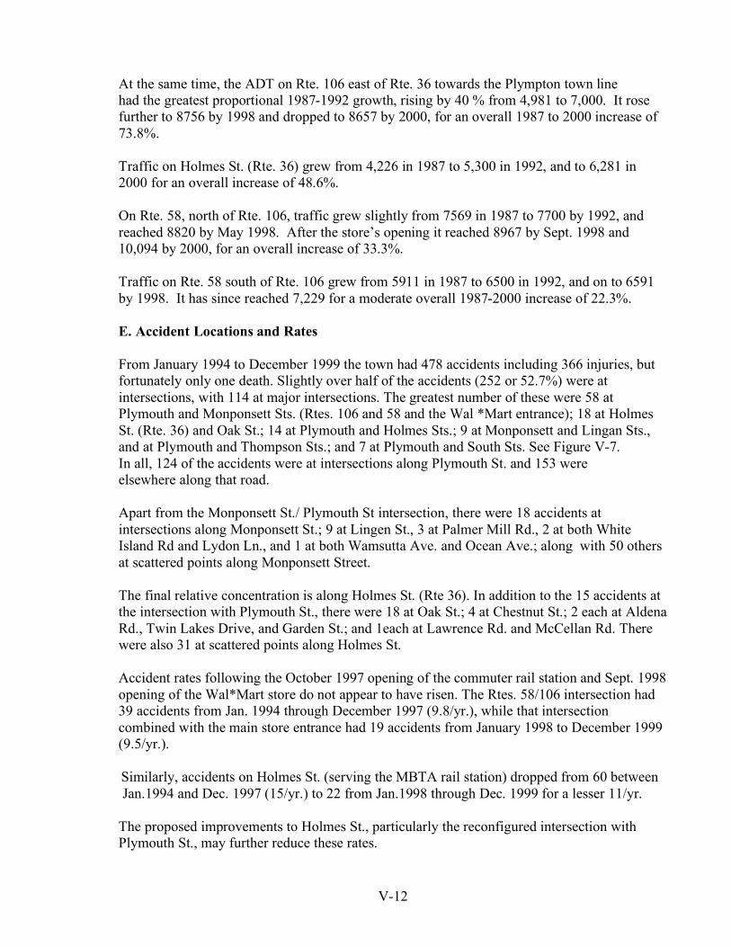
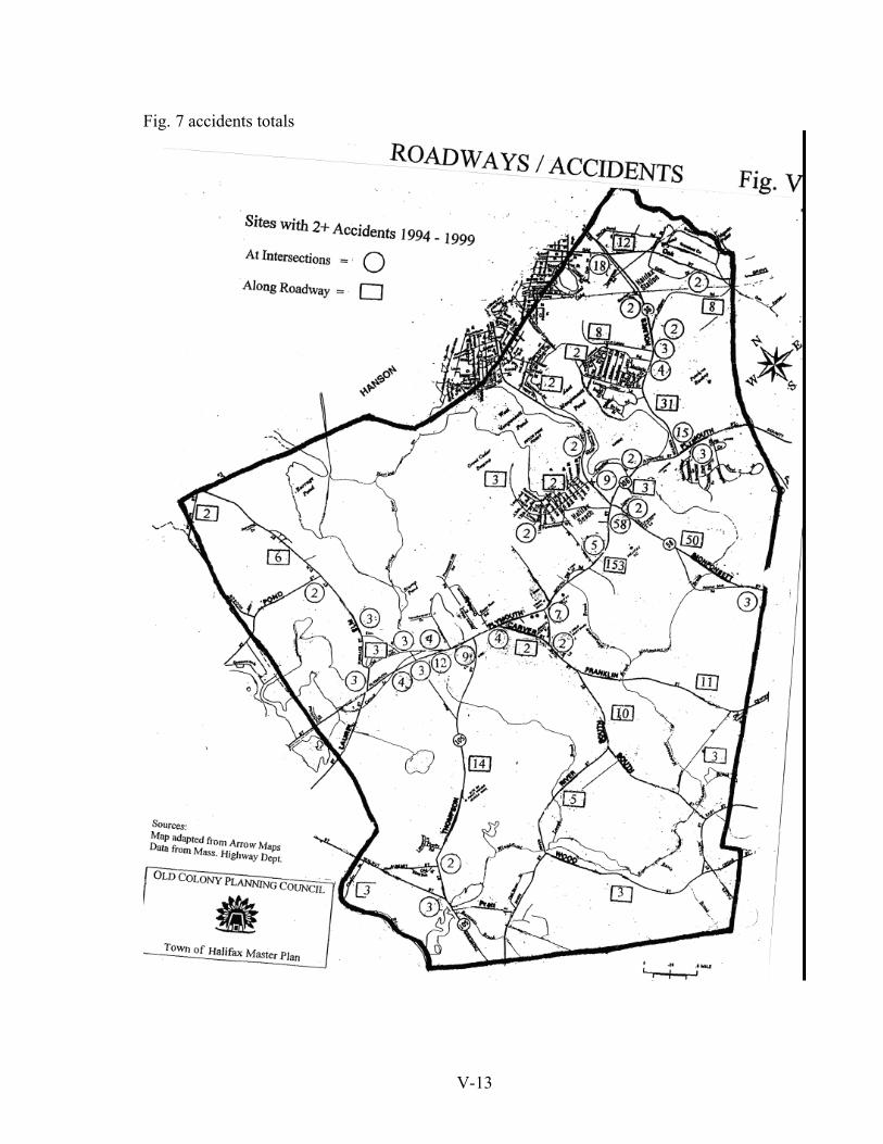
At the same time, the ADT on Rte. 106 east of Rte. 36 towards the Plympton town line had the greatest proportional 1987-1992 growth, rising by 40 % from 4,981 to 7,000. It rose further to 8756 by 1998 and dropped to 8657 by 2000, for an overall 1987 to 2000 increase of 73.8%. Traffic on Holmes St. (Rte. 36) grew from 4,226 in 1987 to 5,300 in 1992, and to 6,281 in 2000 for an overall increase of 48.6%. On Rte. 58, north of Rte. 106, traffic grew slightly from 7569 in 1987 to 7700 by 1992, and reached 8820 by May 1998. After the store’s opening it reached 8967 by Sept. 1998 and 10,094 by 2000, for an overall increase of 33.3%. Traffic on Rte. 58 south of Rte. 106 grew from 5911 in 1987 to 6500 in 1992, and on to 6591 by 1998. It has since reached 7,229 for a moderate overall 1987-2000 increase of 22.3%. E. Accident Locations and Rates From January 1994 to December 1999 the town had 478 accidents including 366 injuries, but fortunately only one death. Slightly over half of the accidents (252 or 52.7%) were at intersections, with 114 at major intersections. The greatest number of these were 58 at Plymouth and Monponsett Sts. (Rtes. 106 and 58 and the Wal *Mart entrance); 18 at Holmes St. (Rte. 36) and Oak St.; 14 at Plymouth and Holmes Sts.; 9 at Monponsett and Lingan Sts., and at Plymouth and Thompson Sts.; and 7 at Plymouth and South Sts. See Figure V-7. In all, 124 of the accidents were at intersections along Plymouth St. and 153 were elsewhere along that road. Apart from the Monponsett St./ Plymouth St intersection, there were 18 accidents at intersections along Monponsett St.; 9 at Lingen St., 3 at Palmer Mill Rd., 2 at both White Island Rd and Lydon Ln., and 1 at both Wamsutta Ave. and Ocean Ave.; along with 50 others at scattered points along Monponsett Street. The final relative concentration is along Holmes St. (Rte 36). In addition to the 15 accidents at the intersection with Plymouth St., there were 18 at Oak St.; 4 at Chestnut St.; 2 each at Aldena Rd., Twin Lakes Drive, and Garden St.; and 1each at Lawrence Rd. and McCellan Rd. There were also 31 at scattered points along Holmes St. Accident rates following the October 1997 opening of the commuter rail station and Sept. 1998 opening of the Wal*Mart store do not appear to have risen. The Rtes. 58/106 intersection had 39 accidents from Jan. 1994 through December 1997 (9.8/yr.), while that intersection combined with the main store entrance had 19 accidents from January 1998 to December 1999 (9.5/yr.).
Similarly, accidents on Holmes St. (serving the MBTA rail station) dropped from 60 between Jan.1994 and Dec. 1997 (15/yr.) to 22 from Jan.1998 through Dec. 1999 for a lesser 11/yr.
The proposed improvements to Holmes St., particularly the reconfigured intersection with Plymouth St., may further reduce these rates.
V-13
Fig. 7 accidents totals
V-14
A less dramatic drop occurred on Plymouth St. (Rte. 106) itself. This arterial road went from 200 accidents from 1994 through 1997 for 50/yr., to 95 from 1998 through 1999 for 47.5 /yr. This general decline in accidents despite growing traffic volumes and more complex activity presumably reflects local drivers’ attentiveness to changing conditions, as well as good visibility along the key section of Rte. 106 between Rtes. 105 and 58, the well- redesigned/signalized Rtes. 106/58 intersection and store access ways, and effective speed limit enforcement. F. Observations Traffic Growth Traffic growth has accelerated with the last two year’s growth often exceeding that for the previous 4-6 years. Growth caused by specific developments such as the Wal*Mart store, the Jordan Hospital Wellness Center on Rte. 106, and the proposed super market may level off once the facilities are established. However, overall traffic will continue to grow with continued residential development. This can be seen in the doubling of volumes on Thompson St. between 1992 and 2000. One concern is whether the recent decline in accidents can continue with further growth in traffic. The greatest volumes are along the central portions of Rte. 106 from the East Bridgewater line to Rte. 58 where some of it turns on to Rte. 36. Volumes here grew by 40.8% from 1987-2000 and this section had the greatest 1998-2000 absolute increase, going from ADTs of 14,304 to 16,040. The 48.6% 1987-2000 increase on Rte. 36 was the greatest of the north-south Rtes. except for that on Thompson St. which started from a much lower point. This presumably reflects the several hundred cars/day going to the Old Colony Railroad Station. The 112% 1987-2000 increase on Thompson St. reflects the extensive residential growth in that area. Impacts of recent and proposed Projects To date, the 93,000 sq. ft. (plus 10,000 sq. ft. garden center) Wal*Mart store has had less measured impact than expected and, reportedly, fewer disruptive impacts than feared. The proponents’ engineers expected 6500 new vehicle trips on a typical weekday, adding 1625 trips to Rte. 106 west of Rte. 58, 1300 trips to Rte. 106 east of Rte. 58, 1300 trips to Rte. 58 south of Rte. 106, 1170 trips to Rte. 58 north of Rte. 106 and 975 trips to Rte. 36. The 5/98– 9/98 period bracketing the opening did not show this increase anywhere. However, as noted earlier, the 5/98 figures may have been inflated by construction traffic, making comparison difficult, and store-generated traffic may not have reached its peak during the first month. Growth from the earlier base figures in 1992 or 1995 to Sept. 1998 appeared consistent with the expected increases except on Rte. 58 south of Rte. 106, and on Rte 36. Fig V-7 Accidents
V-15
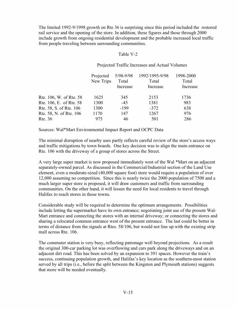
The limited 1992-9/1998 growth on Rte 36 is surprising since this period included the restored rail service and the opening of the store. In addition, these figures and those through 2000 include growth from ongoing residential development and the probable increased local traffic from people traveling between surrounding communities.
Table V-2
Projected Traffic Increases and Actual Volumes Projected 5/98-9/98 1992/1995-9/98 1998-2000 New Trips Total Total Total Increase Increase Increase Rte. 106, W. of Rte. 58 1625 345 2153 1736 Rte. 106, E. of Rte. 58 1300 -45 1381 983 Rte. 58, S. of Rte. 106 1300 -199 -372 638 Rte. 58, N. of Rte. 106 1170 147 1267 976 Rte. 36 975 46 501 286 Sources: Wal*Mart Environmental Impact Report and OCPC Data The minimal disruption of nearby uses partly reflects careful review of the store’s access ways and traffic mitigations by town boards. One key decision was to align the main entrance on Rte. 106 with the driveway of a group of stores across the Street. A very large super market is now proposed immediately west of the Wal *Mart on an adjacent separately-owned parcel. As discussed in the Commercial/Industrial section of the Land Use element, even a moderate-sized (40,000 square foot) store would require a population of over 12,000 assuming no competition. Since this is nearly twice the 2000 population of 7500 and a much larger super store is proposed, it will draw customers and traffic from surrounding communities. On the other hand, it will lessen the need for local residents to travel through Halifax to reach stores in those towns. Considerable study will be required to determine the optimum arrangements. Possibilities include letting the supermarket have its own entrance; negotiating joint use of the present Wal-Mart entrance and connecting the stores with an internal driveway; or connecting the stores and sharing a relocated common entrance west of the present entrance. The last could be better in terms of distance from the signals at Rtes. 58/106, but would not line up with the existing strip mall across Rte. 106. The commuter station is very busy, reflecting patronage well beyond projections. As a result the original 300-car parking lot was overflowing and cars park along the driveways and on an adjacent dirt road. This has been solved by an expansion to 391 spaces. However the train’s success, continuing population growth, and Halifax’s key location as the southern-most station served by all trips (i.e., before the split between the Kingston and Plymouth stations) suggests that more will be needed eventually.
V-16
As noted above, the increase in local traffic is less than projected despite the overflowing parking lot. The 501-trip growth from the 1992 ADT of 5300 to the late 1998 figure of 5801 is well below the 600-700 trips/day expected from the full parking and a moderate number of drop-offs. There reportedly are few drop-offs and much of the patronage probably comes from Pembroke to the North. A moderate increase could remain compatible with the surroundings. Residents of the Twin Lakes townhouses are within walking distance, but the apparent cart path between the development and the station appears to have no convenient access to the station. Needs Route Designations Route 105 stops at Rte. 106 leaving no numbered route from that point to Rte. 27. Drivers must know local roads in order to go directly via Elm St. Continuing the Rte. 105 designation north to Rte 27 via Pine St. and Elm St. would resolve this. The County layout of Pine St. is already 50’, apparently to accommodate improvements supporting such a change. . New Alignments As discussed earlier, the 1964 Master Plan proposed a re-aligned limited-access Rte.106 running south of the present road from Plymouth and Laurel Sts to the present alignment in Plympton, along with a new SW-NE semi-circumferential road from River St. to Rte. 36. These would have eased east-west movement through the region, particularly along the Rte. 106 corridor, and increased access to less developed portions of the town. The question is whether the improvements would be worth the effort. It may be more cost-effective to make incremental improvements at problem intersections, and to minimize commercial curb-cuts and related interruptions to traffic flow, while still allowing access to roadside uses. A more recent proposal is to straighten Rte. 106 from west of Indian Path Rd. to just before Rte 58. This would conflict with extensive commercial uses , especially on the north side of Plymouth St. In addition the time lost going between the old alignment and the new via signalized intersections could reduce the benefits to through traffic. Such proposals to increase west-west capacity along Rte 106 should be examined in the context of an overall study of east-west movement in the greater region. Local Movement The increasing number of subdivisions served by just one major road and having many cul de sacs creates a very inflexible road system and isolates non-drivers. Developments served by only one major road have no alternate routes available in an emergency. No one wants excessive through-traffic on local streets, but it is valuable to have an alternative when needed, or to be able to take local trips by the shortest route. As noted earlier, young people and other non-drivers on long dead-ends are particularly isolated, often having to go far around along major streets to reach a nearby destination. This suggests, at a minimum, having pedestrian / bicycle paths or easements between subdivisions and nearby neighborhoods or other destinations.
V-17
Appearance Subdivision roads which are wider than the roads that serve them, or are severely straight can degrade a rural neighborhood’s visual character. In contrast, a slightly narrower, curved road following the topography can work as well, while complement-ing the landscape and maintaining more of the traditional view from the road. E. Other Modes Other modes can range from regional commuter rail lines, transit bus service, and para- transit services, to bicycling and walking. Commuter Rail Halifax’s main alternate mode is the recently restored Old Colony Commuter rail service. This connects much of Southeastern Massachusetts with Boston, Cambridge and intermediate activity centers such as Quincy Center. It serves Halifax from a handicapped-accessible station on Garden Road off of Rte. 36 in the northeast corner of the town. It is easily accessible from all of the town, and from the adjacent communities of Pembroke and Plympton. The station’s location in the Northeast corner of the town requires most riders to drive or be driven to it, but no more central location was possible on the existing rail line. In addition Halifax riders approach the station while moving in their probable overall direction of travel. Depending on their location, some residents of the western and northwestern portions of the town might find the Hanson station to be more convenient and consistent with their direction of travel. There are 15 round trips/day between Halifax and South Station. Scheduled times range from 44 to 55 minutes in-bound, and from 39 to 52 minutes outbound. Since the rail service increases Halifax’s auto-free access to Boston and Cambridge it is expected to attract new higher-income professionals and skilled workers, thereby increasing the town’s Boston-area focused commuters well beyond the1990 figure of 225 (6.9&%). Bus Service The nearest commuter bus service is that provided by the Plymouth and Brockton Street Railway via local streets in Kingston and Pembroke, and Rte. 3. At its closest this service runs on Rte. 27 about a mile north of the northernmost part of Halifax. There are three morning trips passing through Kingston’s Kingsbury Plaza at 5:41, 6:36, and 7:16 AM, and arriving at South Station at 6:50, 8:00, and 8:40 AM. Return trips leave South Station at 3:10, 4:10, 5:05 and 6:25 PM and pass through Kingsbury Plaza at 4:07, 5:12, 6:22, and 7:42 PM. Scheduled times range from 69 minutes to 84 minutes. Para-Transit Service
V-18
• South Shore Community Action Council (CAC). The non-profit CAC provides service for the elderly and disabled from Monday through Saturday on a 24-hour advance reservation basis. It operates through contracts with various social service agencies and serves Halifax and the adjacent communities.
• Park Wheelchair Transit Co. of Avon. This firm provides demand-responsive service for
the elderly and disabled, and a subscription service for clients of social service agencies. The demand-responsive service operates 7 days a week with 24- hours advance reservation. It serves Halifax and many other Southeastern Massachusetts communities.
• Halifax Council on Aging The Halifax Council on Aging, like others in the region, can arrange to meet individual transit needs. Halifax does not have access to the two major para-transit services, the Brockton Area Transit Authority’s Dial-a Bat. or the MBTA’s The Ride. The town has not decided to join the BAT system to the degree required for Dial-a-Bat service, and the Ride is limited to communities in the basic MBTA district. Bicycling / Walking
The town’s growing sidewalk system has been observed to greatly increase walking from neighborhoods off of Rte. 106 toward the center, and the reported policy of adding sidewalks whenever a major road is improved should further increase this. Yet pedestrians and cyclists should not be forced to travel along major roads if shorter and safer routes are possible. As noted earlier, this suggests enforcing the provisions of the Subdivision Rules and Regulations requiring 20-foot wide easements for utilities, drainage systems or pedestrian/bicycle paths, preferably along rear or side lot lines when necessary. “Necessary” is not defined and few subdivisions are served by such routes. One problem may be that easements within one development may reach no useful destination unless they are tied to subsequent easements through adjacent properties. This suggests consistently requiring such paths, adopting a conceptual town-wide system indicating where new sections would tie into future development, and directly developing paths to allow movement through the town off of Rte. 106. Examples of such paths would be: • A series of path segments going from Thompson St. to River St. (possibly via Orchard
Circle ), then from the junction of River and South Sts. to Franklin St. , then along Palmer Brook to Palmer Brook Road, and on through the mapped cart path to the Mobile Home Park and the junction of Plymouth and Holmes Sts. This would allow riding or walking most of the width of the town off of major roads.
• Creation of a bike lane or a bike/pedestrian bi-way along Holmes St. from Plymouth St to
the T station, and on to the town line.

V-19
• Creation of a local route from the Ridge Road neighborhood, through the Annawon Drive neighborhood and the Twin Lakes development, and on to the MBTA station. This would give those three neighborhoods and points to the south access to the T without driving or riding along Holmes St.
F. Conclusions/Recommendations While Halifax’s roads have limited capacity and many irregular intersections, they appear to be adequate for the town’s probable continued low-density development. Hence they present no major constraints on such growth. However there are some perceived gaps in local east-west movement (e.g., the lack of a local connection between Rte. 58 and Franklin St.) which could be met by requiring such connections through future subdivisions in the area. This would be easier with a town-adopted “Official Map” laying out a coherent long-term roadway system binding on all developers. Recommendations 1. Study extending the Rte. 105 designation through Pine St. and Elm St. to Rte 27
and making required roadway improvements. 2. Require pedestrian / bicycle easements between subdivisions and nearby destinations,
unless explicitly waived during subdivision review.
3. Determine the feasibility of the pedestrian/bicycle ways described above and develop a program to build them.
4. Design/adopt a skeletal town-wide pedestrian/bicycle path system to which individual paths can be connected.
5. Consider adopting a town-wide Official Map laying out a required system of major roads to guide developers.
6 Develop design standards/policies relating subdivision roads to their context,
even things as simple letting roadways be narrower and encouraging them to be slightly curved.
7. Work to combine access roads for the Wal-Mart store and the proposed adjacent
supermarket.
8. Identify and make incremental improvements along Rte. 106 to help to improve East - west movement.
9. Encourage the Massachusetts Highway Dept., the Old Colony Planning Council and the
Southeastern Regional Planning and Economic Development District to study remaining (post Rte. 44 relocation) needs for more east – west capacity through the region.

V-20
10. Develop zoning revisions encouraging shared parking and common driveways
serving groups of stores in order to reduce curb cuts.
12. Seek to produce a more pedestrian–friendly environment by allowing reduced side-yards and front yards through special permits, and by designing intersections to make foot crossing safe and inviting.
13. Encourage pedestrian ways between neighborhoods and major destinations, e.g. between the Twin Lakes development and the nearby MBTA commuter rail station.
14. Identify and commit the resources needed to do the local road condition inventory needed
to complement State and Regional efforts and to fully benefit from the Pavement Management System.
15. Designate all or key parts of certain streets – Old Plymouth, Furnace, Elm, Pratt, River, Wood, South, Franklin, and Hayward – as Scenic Roods where tree-cutting, or stone wall removal require a Planning Board hearing.
16. Work to protect the view from Halifax’s most scenic road, the isthmus section of Monponsett St. between the two lakes.
17. Work with Pembroke to improve / clarify access to the west side of Crystal Lake / Muddy Pond.
18. Lessen the dependence of cul de sac neighborhoods on one connection to a major road. For example, extend Cedar Lane through to Annawon Drive, thereby giving the first neighborhood two ways in and out, and giving each a direct pedestrian / bicycle or auto connection for short trips to each other.
19. Seek to get pedestrian / bicycle connections between deep, unconnected neighborhoods, e.g., between the end of Cranberry Drive and Stoney Weir Road ,and between such neighborhoods and nearby open spaces or public facilities. 20. Cooperate with the town of Pembroke to place historic markers at the ends of Rte. 36, explaining the origin of the state’s shortest numbered route.