Using Technical Expertise at Ostia Antica (Leiden ... · 10 Using Technical Expertise at Ostia...
5
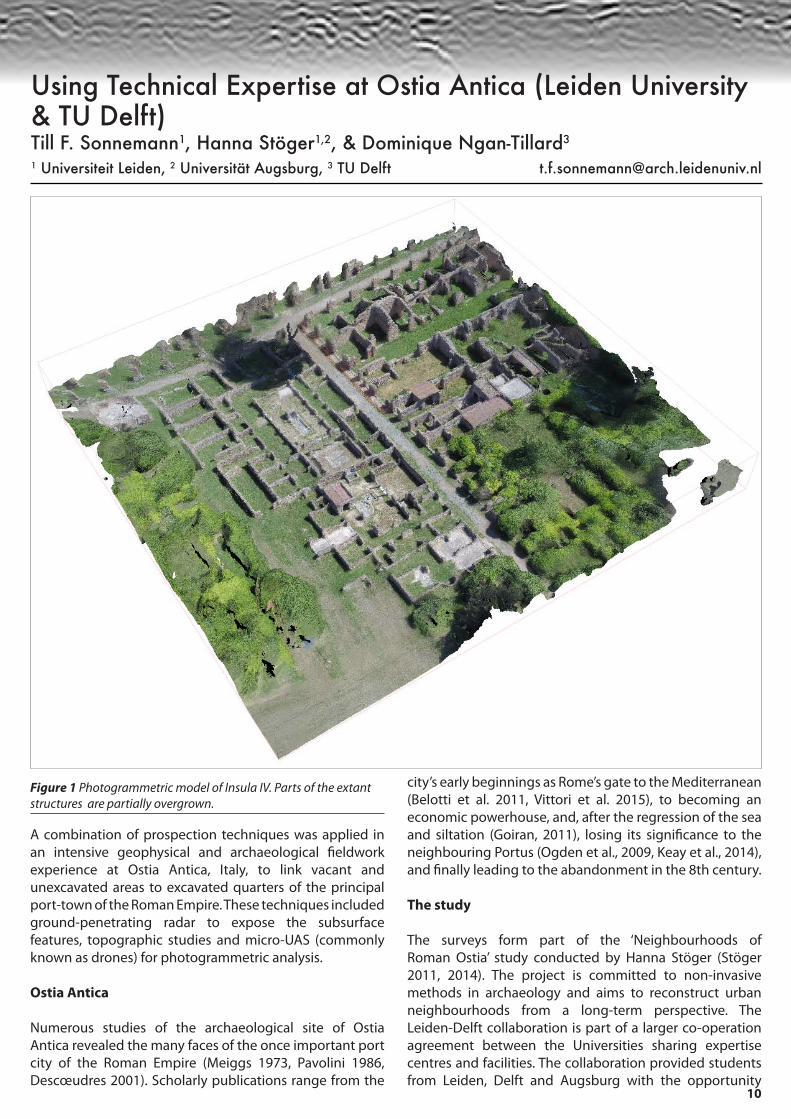
10 Using Technical Expertise at Ostia Antica (Leiden University & TU Delft) Till F. Sonnemann 1 , Hanna Stöger 1,2 , & Dominique Ngan-Tillard 3 1 Universiteit Leiden, 2 Universität Augsburg, 3 TU Delft [email protected] Figure 1 Photogrammetric model of Insula IV. Parts of the extant structures are partially overgrown. A combination of prospection techniques was applied in an intensive geophysical and archaeological fieldwork experience at Ostia Antica, Italy, to link vacant and unexcavated areas to excavated quarters of the principal port-town of the Roman Empire. These techniques included ground-penetrating radar to expose the subsurface features, topographic studies and micro-UAS (commonly known as drones) for photogrammetric analysis. Ostia Antica Numerous studies of the archaeological site of Ostia Antica revealed the many faces of the once important port city of the Roman Empire (Meiggs 1973, Pavolini 1986, Descœudres 2001). Scholarly publications range from the city’s early beginnings as Rome’s gate to the Mediterranean (Belotti et al. 2011, Vittori et al. 2015), to becoming an economic powerhouse, and, after the regression of the sea and siltation (Goiran, 2011), losing its significance to the neighbouring Portus (Ogden et al., 2009, Keay et al., 2014), and finally leading to the abandonment in the 8th century. The study The surveys form part of the ‘Neighbourhoods of Roman Ostia’ study conducted by Hanna Stöger (Stöger 2011, 2014). The project is committed to non-invasive methods in archaeology and aims to reconstruct urban neighbourhoods from a long-term perspective. The Leiden-Delft collaboration is part of a larger co-operation agreement between the Universities sharing expertise centres and facilities. The collaboration provided students from Leiden, Delft and Augsburg with the opportunity
Transcript of Using Technical Expertise at Ostia Antica (Leiden ... · 10 Using Technical Expertise at Ostia...
10
Using Technical Expertise at Ostia Antica (Leiden University & TU Delft)Till F. Sonnemann1, Hanna Stöger1,2, & Dominique Ngan-Tillard3
1 Universiteit Leiden, 2 Universität Augsburg, 3 TU Delft [email protected]
Figure 1 Photogrammetric model of Insula IV. Parts of the extant structures are partially overgrown.
A combination of prospection techniques was applied in an intensive geophysical and archaeological fieldwork experience at Ostia Antica, Italy, to link vacant and unexcavated areas to excavated quarters of the principal port-town of the Roman Empire. These techniques included ground-penetrating radar to expose the subsurface features, topographic studies and micro-UAS (commonly known as drones) for photogrammetric analysis.
Ostia Antica
Numerous studies of the archaeological site of Ostia Antica revealed the many faces of the once important port city of the Roman Empire (Meiggs 1973, Pavolini 1986, Descœudres 2001). Scholarly publications range from the
city’s early beginnings as Rome’s gate to the Mediterranean (Belotti et al. 2011, Vittori et al. 2015), to becoming an economic powerhouse, and, after the regression of the sea and siltation (Goiran, 2011), losing its significance to the neighbouring Portus (Ogden et al., 2009, Keay et al., 2014), and finally leading to the abandonment in the 8th century.
The study
The surveys form part of the ‘Neighbourhoods of Roman Ostia’ study conducted by Hanna Stöger (Stöger 2011, 2014). The project is committed to non-invasive methods in archaeology and aims to reconstruct urban neighbourhoods from a long-term perspective. The Leiden-Delft collaboration is part of a larger co-operation agreement between the Universities sharing expertise centres and facilities. The collaboration provided students from Leiden, Delft and Augsburg with the opportunity

11
Figure 2 (above) Photogrammetric DEM of the area, highlighting slight topographic changes.Figure 3 (below) GPR survey results (depth ~70-100cn), overlaying the UAS orthophotographs; highlighted in red are the structures identified so far.

12
to get hands-on experience in different field techniques, and to collect data for theses on topics ranging from geosciences to civil engineering and architecture.
The goal was to analyse the connection of the built-up insula IV, a set of city blocks in the southeast part of Ostia Antica, with the adjacent vacant, lower lying plots to the south that are now covered by grass. Under strict time constraints it was decided to survey about one hectare using the towing system of an S&S 250MHz antenna. The grid was set up in an angle to the orientation of the buildings. Starting from approximately 50 meters distance to the insula, using 50 cm row spacing over a 250 meters width, the survey terminated in front of the remaining structures. In addition, UAS flights for photogrammetry, processed using Agisoft Photoscan software, and DGPS surveys were conducted to create detailed topographic maps and orthophotographs of the area.
The 250MHz antenna received data to about 120cm, possibly caused either by a cover of rubble remaining from the once spread out city, or diffused by salt intrusion of the close sea. Data processing, using ReflexW software, included start time fix, max. phase correction, background removal and applying median filters and gain. Deep plowing has significantly affected the top soil, nevertheless the collected GPR data shows a number of significant features. Below an elevated area in the west (grids 1 & 2 - fig. 2), linear features give evidence of remains of built structures. To the east (particularly in grids 8 & 9) there is additional evidence of human landscape modifications; linear features speaking for masonry walls, and rectangular features indicating potential floors or cisterns. Further research is required to clarify whether the missing evidence is due to the environmental circumstances or the actual lack of built structures in this area.
The results of the surveys were processed as part of two jointly supervised bachelor theses at TU Delft and serve as the base for a master thesis at the University of Leiden. This multi-disciplinary research will hopefully lead to further successful collaborations in the near future.
Acknowledgements
The fieldschool in Ostia was organized within the EU-funded ArchaeoLandscape project. The Authors would like to thank Eraldo Brandimarte and Eric Dullart for providing their expertise. Members of the survey team were Tim Beerens, Thomas Dworschak, Alexander Jansen, Lars Schaarman, Martijn Warnaar and Thierry van ’t Westenende. Our gratitude goes to the Soprintendenza of Rome (Sede Ostia) and the staff at Ostia Antica, and particularly to Dean Goodman (gpr-survey.com) for allowing the Delft students to work with his software.
References
Belotti, P., Calderoni, G., Di Rita, F., D’Orefice, M., D’Amico, C., Esu, D., Magri, D., Preite Martinez, M., Tortora, P., and P. Valeri. 2011. “The Tiber River delta plain (central Italy): Coastal evolution and implications for the ancient Ostia Roman settlement.” The Holocene 21, 7: 1105-1116.
Descoeudres, J.-P. (Ed.). 2001. Ostia: port et porte de la Rome antique. Geneve: Ville de Geneve, Department des affaires culturelles.
Goiran, J., Salomon, F., Mazzini, I., Bravard, J., Pleuger, E., Vitorri, C., Boetto, G., Christiansen, J., Arnaud, P., Pellegrimo, A., Pepe C., and L. Sadori. 2014. “Geoarchaeology confirms location of the ancient harbour basin of Ostia (Italy).” J. Archaeol. Sci. 41: 389-398.
Keay, S., Parcak, S., and K. Strutt. 2014. “High resolution space and ground-based remote sensing and implications for landscape archaeology: the case from Portus, Italy.” J. of Archaeol. Sci. 52: 277–292
Meiggs, R. (1973, 1st edition 1960). Roman Ostia. Oxford: Clarendon Press.
Ogden, J., Keay, S., Earl, G., Strutt, K., and S. Kay 2009. “Geophysical Prospection at Portus: An Evaluation of an integrated Approach to the interpretation of Subsurface Archaeological Features.” In: Frischer, B., J. Webb Crawford and D. Koller (eds.): Making History Interactive. BAR International Series S2079: 273-284.
Stephani, M., Becker, H., Brand, R., and J. Fassbinder. 2000. “Fusion of aerial images and magnetic prospection for archaeology.” International Archives of Photogrammetry and Remote Sensing. Vol XXXIII, Part B5, Amsterdam: 764-771.
Stöger, H. 2011. Rethinking Ostia: A spatial enquiry into the urban society of Rome’s imperial Port-Town. Leiden: Leiden University Press.
Stöger, H. 2014. The spatial signature of an Insula neighbourhood of Roman Ostia. In: Paliou Elefteria, Lieberwirth Undine, Polla Silvia (Eds.) Spatial analysis and social spaces: Interdisciplinary Approaches to the Interpretation of Prehistoric and Historic Built Environments. no. 18. Berlin and Boston: De Gruyter: 297-316.
Vitorri, C., Mazzini, I., Salomon, F., Goiran, J., Panuzzi, S., Rosa C., and A. Pellegrimo. 2015. “Palaeonenvironmental evolution of the ancient lagoon of Ostia Antica (Tiber delta, Italy).” J. Archaeol. Sci. 54: 374–384.

1
The newsletter of the International Society for Archaeological Prospection Issue 44October 2015
New Surveysat Verulamium Magnitude Surveys’
Big Day OutCombined Survey at Ostia Antica

2
Welcome to the 44th issue of ISAP News! And welcome to Paul Johnson as ISAP News co-editor. It was nice to catch up with familiar and new faces
at the ICAP conference in Warsaw in September, and, of course, we hope you are feeling suitably inspired to write up your current projects for the next issue of ISAP News!
This issue has a slight community geophysics bias: firstly, we have an account of Magnitude Surveys’ experience hosting a community geophysics day;
secondly, we have some preliminary results of magnetic and radar surveys conducted at Verulamium by the Community Archaeology Geophysics Group there. Meanwhile, we also have details of intensive survey conducted using a combination of techniques at Ostia Antica, Italy.
Please send any contributions, notifications, and cover images for the next newsletter (ISAP News 45) to the email address below by the 31st December 2015. All
entries are gratefully received!
Hannah Brown & Paul Johnson
The Cover Photograph shows children of various ages using a multimeter to investigate the electrical properties of conducting clay during a geophysics open day run by Big Heritage and Magnitude Surveys. (Photo: Magnitude Surveys)
Below: delegates at the recent ICAP conference in Warsaw. (Photo: Robert Ryndziewicz)
Organizers of the AP2015 Conference would like to inform readers that the blank pages of the conference website (http://www.iaepan.vot.pl/ap2015/) (i.e. list of participants, list of authors and photographs) are currently being completed and will be activated by the end of October.
Our Big Day Out: #digblacon with Big HeritageChrys Harris, Graeme Attwood & Finnegan Pope-Carter
New Surveys at VerulamiumKris Lockyear
Using Technical Expertise at Ostia Antica(Leiden University & TU Delft)
Till F. Sonnemann, Hanna Stöger &Dominique Ngan-Tillard
Journal Notification
Academic Courses
3
6
10
13
14
Membership renewal £7 or €10 for the whole year. Please visit:http://www.archprospection.org/renew
Archaeological Prospection JournalTake advantage of the great deal offered to ISAP members by Wiley-Blackwell for this journal:http://www.archprospection.org/wiley
The views expressed in all articles are of the author, and by publishing the article in ISAP News, the ISAP management committee does not endorse them either positively or negatively. Members are encouraged to contact authors directly or to use the discussion list to air their views, should they have any comments about any particular article.