URBAN LAND USE PLANNING SCOPES IN POST-WAR CITY OF MONROVIA, REPUBLIC OF...
12
All rights reserved by www.ijaresm.net ISSN : 2394-1766 1 URBAN LAND USE PLANNING SCOPES IN POST-WAR CITY OF MONROVIA, REPUBLIC OF LIBERIA Edmond K. P. P. Lloyd 1 , Bhasker VijayKumar Bhatt 2 , Himanshu J. Padhya 3 PG Student (M. E. - Town & Country Planning), Sarvajanik Collage of Engineering & Technology, Surat, Gujarat, India 1 PG in charge (ME-TCP) and Assistance Professor in Civil Engineering Department, Sarvajanik Collage of Engineering & Technology, Surat, Gujarat, India 2 Associate Professor in Civil Engineering Department, Sarvajanik Collage of Engineering & Technology, Surat, Gujarat, India 3 Abstract: Sustainable development is a significant concern in the 21st century around the world. The world is becoming a global village. The top most priority is to use available resources without compromising the need for the future generations with an emphasis on social, economic and environmental parameters. In the context of urban land use planning, the sustainable term means to address major aspects of a city inclusive of the urban sprawl, transportation network, socio-economic development, city expansion, various land uses, and so on. It all contributes to improving the standards of living and make an urban environment livable. This paper focuses on identification of the need for formal land use planning using GIS tools. The paper discusses the situation on urban land use planning for a case from Post-War City of Monrovia, Republic of Liberia, which was ravaged by 14 years in civil conflicts. In the decade of 1980, by the then planners attempted to formalize land use. However, in the duration of the war, haphazard development evolved which need to be addressed in the post-war condition of present time. At the stage, research reveals that the efforts are essential to treat from scratch. Monrovia habitats a population of about 1.2 million wherein the density of population is very low spreading over a large space. A compact and sustainable planning considering the land use is emphases in the paper. For identification of current land use and to address diverse issues in relation, GIS tools are extensively used for deriving interventions and interpretations. Keywords: Civil conflict, GIS, Informal Settlement, Land use planning, Monrovia, Sustainable development INTRODUCTION Over 90% of urban growth is occurring in the developing world (Bank, 2011). The report estimated that 70 million new residents are added to cities each year. In the next two decades, the urban population of the world’s poorest regions, South Asia, and Sub-
Transcript of URBAN LAND USE PLANNING SCOPES IN POST-WAR CITY OF MONROVIA, REPUBLIC OF...

All rights reserved by www.ijaresm.net ISSN : 2394-1766 1
URBAN LAND USE PLANNING SCOPES IN POST-WAR
CITY OF MONROVIA, REPUBLIC OF LIBERIA Edmond K. P. P. Lloyd
1, Bhasker VijayKumar Bhatt
2, Himanshu J. Padhya
3
PG Student (M. E. - Town & Country Planning), Sarvajanik Collage of Engineering &
Technology, Surat, Gujarat, India1
PG in charge (ME-TCP) and Assistance Professor in Civil Engineering Department,
Sarvajanik Collage of Engineering & Technology, Surat, Gujarat, India2
Associate Professor in Civil Engineering Department, Sarvajanik Collage of Engineering &
Technology, Surat, Gujarat, India3
Abstract: Sustainable development is a significant concern in the 21st century around the
world. The world is becoming a global village. The top most priority is to use available
resources without compromising the need for the future generations with an emphasis on
social, economic and environmental parameters. In the context of urban land use
planning, the sustainable term means to address major aspects of a city inclusive of the
urban sprawl, transportation network, socio-economic development, city expansion,
various land uses, and so on. It all contributes to improving the standards of living and
make an urban environment livable. This paper focuses on identification of the need for
formal land use planning using GIS tools. The paper discusses the situation on urban land
use planning for a case from Post-War City of Monrovia, Republic of Liberia, which was
ravaged by 14 years in civil conflicts. In the decade of 1980, by the then planners attempted
to formalize land use. However, in the duration of the war, haphazard development evolved
which need to be addressed in the post-war condition of present time. At the stage, research
reveals that the efforts are essential to treat from scratch. Monrovia habitats a population
of about 1.2 million wherein the density of population is very low spreading over a large
space. A compact and sustainable planning considering the land use is emphases in the
paper. For identification of current land use and to address diverse issues in relation, GIS
tools are extensively used for deriving interventions and interpretations.
Keywords: Civil conflict, GIS, Informal Settlement, Land use planning, Monrovia,
Sustainable development
INTRODUCTION
Over 90% of urban growth is occurring in the developing world (Bank, 2011). The
report estimated that 70 million new residents are added to cities each year. In the next
two decades, the urban population of the world’s poorest regions, South Asia, and Sub-

IJARESM
All rights reserved by www.ijaresm.net ISSN : 2394-1766 2
Saharan Africa is expected to double. Approximately a quarter of the world’s urban
population lives in slums (UN-Habitat, Prosperity of Cities, 2013). In the State of the
World’s Cities 2012/2013, UN-Habitat estimated the number of residents in the slums of
the world’s developing regions as 863 million, in contrast to 760 million in 2000 and 650
in 1990. On increasing urbanization scenario, this figure is likely to have increased by
2016. These estimates suggest that one-third of the developing world’s urban population
is living in slums (Global Urban Observatory, 2012), representing 15%of all the
inhabitants of those regions.
Over half of the urban population (61.7%) lives in slums in Africa (UN-Habitat, 2013).
In Asia, 30% of the urban population also resides in slums ( (UN-Habitat, Prosperity of
Cities, 2013)), and half of the urban population of the world lives in Asia. In the Latin
America and Caribbean region, an area where slum upgrading and housing strategies
have historically contributed to providing housing solutions to its citizens, still the
problem prevails with a 24% rate of urban slum-dwellers (UN-Habitat, Prosperity of
Cities, 2013). Slums are instinctively evolving as a prevailing and distinct kind of
settlement in urban areas of the developing world. According to the State of the World’s
Cities Report (State of the World's Cities, 2010), every year, 10 million more people are
added to the urban population of Sub-Saharan Africa. Approximately one-third of
these, or 3 million, move to ‘formal’ urban areas. They act both as agents and
beneficiaries of formal urban and economic growth. The remaining two-thirds, or 7
million, move to informal settlements or slums. Of these, only 2 million can expect to lift
themselves out of slum conditions and the other 5 million will remain confined on the
wrong side of the urban divide. Improved global awareness is required to comprehend
adequately and plan for the massive expansion of cities in developing countries. Local
bodies and national governments, civic establishments, international groups, as well as
concerned citizens will need to take maximum responsibilities to cope with the changing
environments.
CHALLENGES FOR URBAN DEVELOPMENT IN DEVELOPING COUNTRIES
The latest Global Report on Human Settlements prepared by UN‐HABITAT, entitled
increasing synergy greater national ownership (UN-HABITAT, 2015) classifies seven current
and future global urban challenges. These are: climate change and resilience of cities, the
increase of inequalities in cities, emergence of new forms of urban poverty, risk and
marginalization in developed countries, unemployment: the youth and social unrest,
Demographic changes in cities: aging populations and the youth bulge, commodification of
land and housing, amplification of different types of crises. Many scholarly articles and
international publications have argued that urban planning in the 21st Century must take
place with the basic understanding of these challenges and emerging factors which lead to a
new urban spatial structure of large, multiple nuclei and polycentric regions.
DRIVERS OF LAND USE
Following the different land uses over time and space enable to understand a history of their
development. The know of the dynamics and urban morphology of cities can be useful for
future urban planning practices. Figure below depicts the factors that determine the land use
patterns for an urban area, once get developed. These contributing factors are: Natural

IJARESM
All rights reserved by www.ijaresm.net ISSN : 2394-1766 3
environment, demographics changes, economic activities, transportation system, consumer
preferences, land ownership and management, policy regulation and management. The
governance of these factors determine the urbanization extent.
Figure 1 Factors that determine land use patterns
EXPERIENCE FROM THE CITY OF MONROVIA, REPUBLIC OF LIBERIA
The city of Monrovia is the capital of Africa's oldest nation Liberia. As a result of the 14
years’ civil war, almost of the infrastructures facilities were destroyed. Apart from the
destruction was also stagnation regarding maintenance of existing infrastructure and a rapid
increase in the use of these infrastructures due to internal migration into Monrovia. The main
sewage system, initially built for a population of 400 was destroyed during the civil war
(Liberia Settlement and Shelter Rehabilitation Programme). Urban roads in Monrovia, power
generation network, distribution facilities, water supply network and such were greatly
affected due to this civil war. The population of Monrovia in 1984 was 421,053 people and
1,010,575 people in 2008. The first population census was executed in 1962, follow by 1974
and 1984. Nevertheless, the original drafts and data of the 1984 census were misplaced
during the civil war and detail results were never revealed. For that reason, the population
Census that was conducted in March 2008, the first time after 24 years, tremendously
characterizes critical data for this study.
Table 1 Population Concentration in Montserrado hosting Monrovia
Zone
Code
Zone Name Population 2008/1
984
Area
(ha)
Density
(persons/ha) 2008 1984
1 New Kru Town 73379 46561 1.576 515 142.4
2 Logan Town 58168 40754 1.427 627 92.8
3 Clara Town 55,462 16,181 3.428 244 227.8
4 West Point 29,516 22,499 1.312 53 558
5 Central Monrovia A 42,139 39,562 1.065 246 171.4
6 Central Monrovia B 40,688 54,770 0.743 213 191.5
7 Sinkor 43,780 321 136.6
8 Lakpazee 42,045 441 95.4
9 Old Road 48,274 554 87.2
10 Congo Town 25,217 784 32.2
Sub-Total 159,316 95,426 1.67 2,099 75.9
11 Paynesville 350998 46,477 7.552 9,130 38.4
12 Gardnesville 80,397 40,707 1.975 1,221 65.8
13 New Georgia 54,188 11,232 4.824 1,052 51.5
14 Barnesville 35,224 6,884 5.117 1,212 29.1

IJARESM
All rights reserved by www.ijaresm.net ISSN : 2394-1766 4
SUB-TOTAL 979475 421,05
3
2.326 16,612 59
15 Johnsonville 4,514 3,203 1.4
16 Caldwell 26,586 3,008 8.8
GREATER
MONROVIA
1010575 22,823 44.3
Figure 2 Political Map of Monrovia
Source: LIGISS (Census 2008)
According to the findings of the Census in June 2008, the population of Liberia in 2008 is
3,489,072, demonstrating an increase of 1.66 times from the figure of 2,101,628 in 1984.
This leads to an annual population growth rate of population 2.1% over this period. It is much
smaller than the growth rate of 3.3% in 1974 and 3.4% in 1984 (see Table below). It is
believed that the figure would have been similar to this if Liberia did not experience the civil
conflicts.
Figure 3 Population in Liberia
Index 1962 1974 1984 2008
Population 1016443 1503368 2101628 3489072
Population Change 486925 598260 1387444
Average annual increase 40577 59826 57810
Percentage increase 47.9 39.8 66
Annual rate of growth 3.3 3.4 2.1
Source: LIGISS (Census 2008)
Urban population growth rate is 5.65% (UN-Habitat 2009). Settlement comprising of 2000 or
more people is referred to as an "urban" settlement in Liberia. These urbanization criteria
propose that more than half of the population now live in distributed settlements showing
rapid urbanization from "rural to urban" and from "urban to urban." Furthermore, urban
description, functions, categorization and quality of human settlements in Liberia disclose
broad limitations in the management of urban areas in the field of urban governance, urban
policy formulation, and implementation, urban land management, finance, and
administration. Current policies, regulatory and legal frameworks and mechanisms for human
IJARESM
All rights reserved by www.ijaresm.net ISSN : 2394-1766 5
settlements and urban related matters are disjointed and dissimilated among weakly
harmonized ministries and agencies in Liberia.
Considerable urban issues have come out due to the rapid urbanization in Monrovia. The
majority of the housing stocks (at least 80%) has been destroyed by the 14 years of civil
unrest or a diverse situation of disrepair. Diversity of urban settlements in the ladder of
human settlement (from the lowest to the highest settlements), poor urban policy and weak
governance formation, inefficient decentralization policies, poor urban planning, lack of land
for housing project and weak housing policies for shelter delivery to the urban poor and
inadequate finance to undertake government schemes and policies are among the many other
problems as the result of rapid urbanization. Additionally, slums are rapidly escalating, and
there is little slum upgrading action being undertaken. More than 1.4 million inhabitants live
on less than USD 0.50 cents per day (UN-Habitat 2008). Extensive urban poverty is an
eminent attribute. Massive unemployment among urban population (especially youths) which
put a serious heaviness on the poor. There are inadequate urban infrastructures facilities
which pose a serious threat to the quality of life at all levels. Poor garbage collection
mechanisms for the disposal of solid wastes in urban areas.
There are huge gaps between human settlements and urban policies in Liberia, which has led
to rapid and haphazard urban sprawl settlements. When urban policies couple with
governance function in collaboration with a central government structure, uncontrolled
growth and improper management of urban land become controlled and planned. Liberia is in
a state of post-conflict rehabilitation and reconstruction. With the long years of civil conflict
Liberia have experienced, she has been gradually progressing for more than ten years of
peace. With this progress being made, there are still urban governance, urban land
management and policy formulation and implementation problems in Liberia. More than 50%
of the population in Liberia now live in cities. More than 1.2 million of the population live in
Monrovia. As a result of this rapid urbanization serious threat has been posed to the economy
and infrastructures in Liberia with more emphasis on the lack of housing stock. In Monrovia,
most of the population are prioritizing the periphery with the availability of land to meet their
housing needs. This rapid urbanization has also lead to the creation of informal settlements in
many parts of Monrovia
Poor land management was part of the reasons why Liberia experienced the extended period
of civil unrest. Land rights were poorly regulated in the past this led Liberia into a
predicament and a period of long-suffering and backwardness. Agrarian reform has taken a
shape in the administration of President Ellen Johnson Sirleaf because it has been given a
high priority. Issues of land management and administration of urban land discussed at a
national conference in 2009 in President Ellen Johnson Sirleaf emphasized on agrarian
reform as a national priority for the growth and development of Liberia. Monrovia being the
largest urban area in Liberia has experienced the most rapid urbanization. It has been
characterized by the following problems:
• Weak Legal and regulatory framework for land use planning
• Poor urban local governance administration
• Lack of coordination between Agencies and Ministries responsible for urban planning
in Monrovia
• Zoning Laws/regulations are out-dated

IJARESM
All rights reserved by www.ijaresm.net ISSN : 2394-1766 6
• Maximum increase in informal and unplanned settlements
• Damage infrastructures
• Rapid peri-urban growth
• Poor enforcement mechanisms
It has realized that the population is concentrated in Montserrado County which holds
Monrovia. That is empirical as a result of rural to urban migration to the civil war which led
people to seek a better life. According to the 2008 Census, the population of Montserrado
accounts for about one-third of the national population. Since this ratio was just under one-
quarter in 1984, it can be seen that population concentration into Montserrado is advancing.
The same conclusion may also be strained from the county separate population growth rates.
Figure 4 Population Concentration in Montserrado hosting Monrovia
Source: LIGISS (Census 2008)
From the above figures, it is noted that majority of the urban population is concentrated in
Montserrado County hosting Monrovia. Population density is moderately high in the CBD
area and high in the Clara Town and West Points Communities that comprise of the highest
slum populations in Monrovia.
A. Prospects in urban land use planning in Monrovia
The UN-Habitat and the Government of Liberia organized a National Urban Forum in
Monrovia, Liberia June 24 and 25 2015 under the theme "Towards a National Urban Policy"
to give advice on the roadmap towards sustainable urbanization in Liberia. The City
Government of Monrovia, the Ministry of Internal Affairs, the Land Commission, Cities
Alliance and the UN-Habitat organized the National Urban Forum. The population of Liberia
is a little over 4 million people. 2.1 of these people in urban areas and a significant portion of
1.5 million live in Monrovia. Presently, secondary cities next to Monrovia characteristically
have less than 100,000 people.
The National Urban Forum in Monrovia highlight that cities can be engines of growth and
well- managed urbanization can increase human welfare and the creation of wealth (UN-
Habitat, Country Programme Document, 2009). Globally cities produce about 70% of the
National GDP though they host only 50% of the national population or even fewer in some
Sub-Saharan African countries. Liberia has made progressive achievements towards
sustainable urbanization including the drafting of the Housing Policy, Urban Land
Inventories, Decentralisation and Deconcentration Policy and the political motivation to
prioritize urban development through a National Urban Policy. About 70% of the urban
population live in slums in Monrovia. After results gathered from slum profiling, availability
of and better water, sanitation facilities, housing and secure tenure are all insufficient and
IJARESM
All rights reserved by www.ijaresm.net ISSN : 2394-1766 7
barely available in slum communities. Putting slum communities at the center of upgrading
process and using participatory planning approaches for comprehensive urbanization is
necessary to improve the quality of life. The prevention of new slums through satisfactory
and affordable housing schemes improves the general prosperity of a city.
The National Urban Policy is the heart of sustainable urbanization as it forms a managerial
organization that strengthens the urbanization process, coordinates the affairs of different
sectors and the various levels of government, and establishes a more sustainable way to
manage resources. The National Urban Policy provides a national vision, principles, and
direction. An incorporated development policy connecting legal and regulatory frameworks,
monetary and urban planning framework that developed with the participation of all involves
stakeholders to change the approaches towards urbanization in Liberia. Slums and affordable
housing are also at the center of the National Urban Policy to provide better life and shelter
for the urban poor.
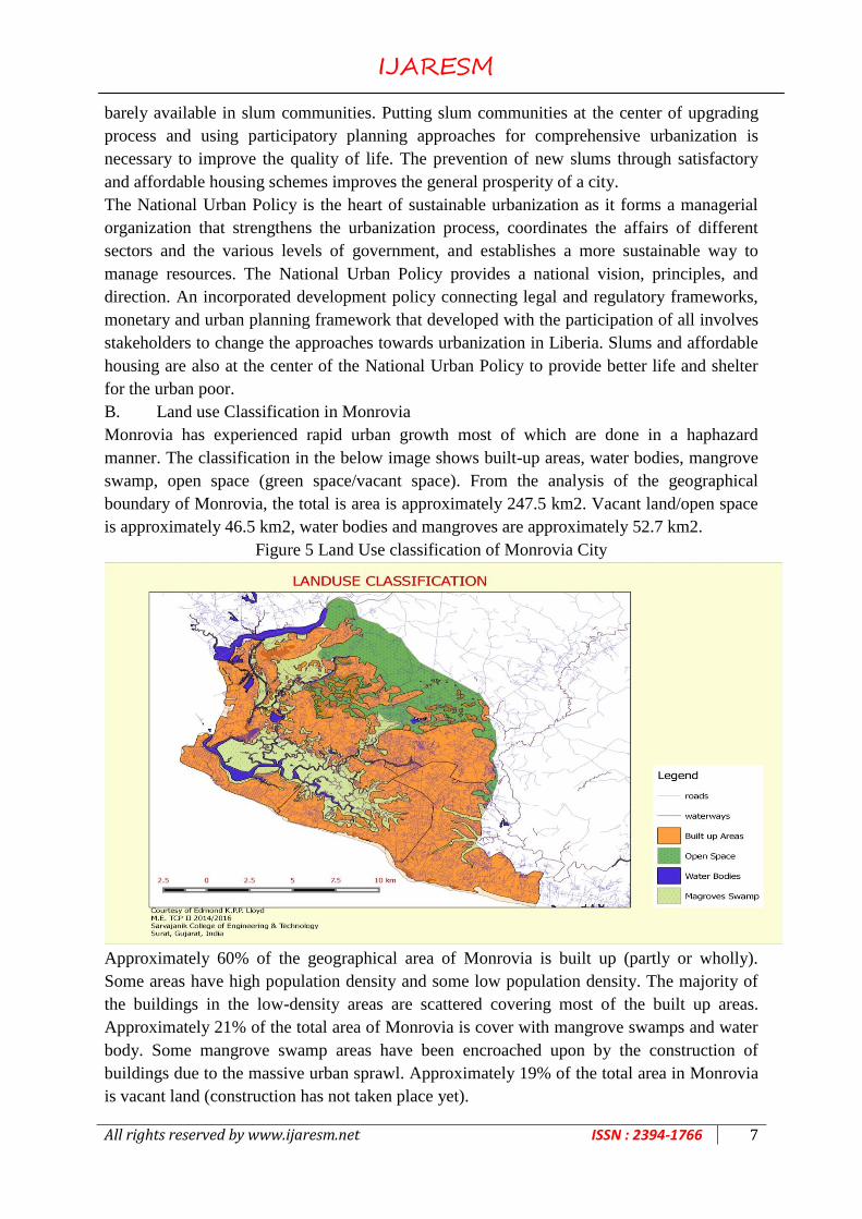
B. Land use Classification in Monrovia
Monrovia has experienced rapid urban growth most of which are done in a haphazard
manner. The classification in the below image shows built-up areas, water bodies, mangrove
swamp, open space (green space/vacant space). From the analysis of the geographical
boundary of Monrovia, the total is area is approximately 247.5 km2. Vacant land/open space
is approximately 46.5 km2, water bodies and mangroves are approximately 52.7 km2.
Figure 5 Land Use classification of Monrovia City
Approximately 60% of the geographical area of Monrovia is built up (partly or wholly).
Some areas have high population density and some low population density. The majority of
the buildings in the low-density areas are scattered covering most of the built up areas.
Approximately 21% of the total area of Monrovia is cover with mangrove swamps and water
body. Some mangrove swamp areas have been encroached upon by the construction of
buildings due to the massive urban sprawl. Approximately 19% of the total area in Monrovia
is vacant land (construction has not taken place yet).

IJARESM
All rights reserved by www.ijaresm.net ISSN : 2394-1766 8
Table 2 Planning problems in City of Monrovia
Description Present scenarios Planning problems
Urban
Sprawl Urban settlements and industries are sprawling in
mangrove swamp affecting mostly Paynesville,
Caldwell, Johnsonville, and Barnesville
Proper boundaries need
to be decided by
authorities to control the
urban sprawl in
Monrovia
Change in
Land uses Central Business District
Densely populated informal settlements due to
high opportunities in Monrovia
Unused high rise buildings in CBD area
Informal settlements
Approximately 90% of the settlements covering
the built-up area are rented houses
Electricity, water, road, utilities, and such has
not been restored properly since the civil
conflict, population inflow in Monrovia is also
worsening the situation
Large scale ongoing low rise settlements
Lack of integrated Local Plans for road network,
future sewerage and water supply systems not
undertaken Future growth of urban center not
established yet
There is a lack of
adequate Urban Master
Plan for Monrovia. The
weak intuitional
capacity of government
agencies responsible
planning, lack of trained
staff, lack of equipment,
and so on.
Local and Annual action
plans are needed to
address this growing
need
C. Present Land Use Pattern in Monrovia
The land use pattern of Monrovia shows that most of the built up areas are cover by low and
medium densities housing. It depicts that the built up areas will increase at a higher rate
because most people and are not high-income earners. They can only afford to build low
houses for the purpose of shelters.
Figure 6 Present Land Use Pattern in Monrovia

IJARESM
All rights reserved by www.ijaresm.net ISSN : 2394-1766 9
D. Road Transportation in Monrovia
Before the inauguration of the government in 2006, the transport management sector in
Liberia was divided among numerous Ministries. The Ministry of Transport (MOT) was
responsible for transport sector policy formulation, regulation, and implementation.
Managing national road network was divided between the Ministry of Public Works
(responsible for the primary and secondary roads) and the Ministry of Rural Development
(responsible for feeder and farm-to-market roads).
Figure 7 Transportation Network in Monrovia
Due to the Liberian civil conflict, these Ministries lost their capacities to manage their
relevant functions. Major data and documents were lost. In past, the ministries relied on
collective memory to establish road data. Ministries were unable to undertake regular road
condition and traffic assessments and confirm that approximately no road maintenance was
conducted between 1986 to 2006. As a result of this lack of maintenance, most roads are in
destitute conditions up to now. Transportation networks link all the main economic areas to
one another in Monrovia and also link the city to national highways in Liberia.
E. Existing Policies and Regulations
National Transportation Policy and Strategy (NTPS) The new National Transport Policy and
Strategy (NTPS) was officially approved in November 2008 by Government of Liberia with
technical and financial support from the World Bank. The NTPS defines the vision for
transport in Liberia. It is a guide to decision making by the Government and its various
agencies. It will provide a point of reference for local authorities, business, and communities.
The objectives of the NTPS are to make transport financially and economically sustainable;
accessible to all persons, including the physically challenged and elderly; affordable to all

IJARESM
All rights reserved by www.ijaresm.net ISSN : 2394-1766 10
strata of society; safe to ensure high standards of health and personal security for all
individuals, including users, workers, and operators; and environmentally sound.
F. Multi-Core Urban Corridor pattern
Monrovia comprises of Central Business District (CBD) which is located in Central
Monrovia is shown in red in the below figure. Most of the traffic are directed towards the
CBD area. There are also four core areas which have basic economic activities, and some of
the traffic are oriented towards these regions. Core Area 1 (ELWA Junction) holds traffic
from the Roberts International Airport, Central Monrovia, and Red light.
Figure 8 Multi Core Urban Corridor Pattern in Monrovia City
Core Area 2 (Red Light) holds major economic activities and has one of the largest markets
in Monrovia. It connects traffic from ELWA Junction; Somalia drives road and the national
highway to Kakata connecting most of the Liberia. Core Area 3 (Clara Town/Freeport Area)
comprise of economic activities which are mostly industrial. It is around the Freeport of
Monrovia and connects Central Monrovia, Red Light, and traffic from Logan Town. Core
Area 4 (Logan Town) is a populated business area which has many informal markets
activities. Along all the key roads, there are mixed-use (commercial and residential) land uses
which indicate that businesses are highly taking place along transportation corridors in
Monrovia.
CONCLUSION
Adequate urban planning and planning city expansion is of the most efficient ways to prevent
the formation of slums and improve urban life as it deals with urban space for future growth
and encouraging compact urban communities for sustainable development. To attain
sustainable development, all national development policies should aim at achieving the
IJARESM
All rights reserved by www.ijaresm.net ISSN : 2394-1766 11
sustainable development goals. In Monrovia, little attention has been paid to attaining
sustainable urban planning because the city was ravaged by 14 years’ civil conflicts which
destroyed major infrastructures and diminished the economy of Liberia.
Absence of Urban Planning Guidelines, lack of Development Control Regulations, lack of
coordination between Ministries and agencies responsible for urban planning in Monrovia,
low government enforcement mechanism, low budgetary allocation for Municipalities and
Agencies responsible for urban planning, lack of public awareness about zoning laws and
municipal regulations are among major factors serving as hindrances to Urban Planning in
Monrovia.
There have been recent policies framed by the government of Liberia and its International to
restored and improved the quality of life in Monrovia towards sustainable development
through the National Urban Policy. It will give way to improved planning mechanisms which
will enable a planned growth.
REFERENCES
[01] Afolabi Aribigbola, P. M. (2007). Urban Land Use Planning, Policies, and Management
in Sub-Saharan African Countries: Empirical Evidence from Akure, Nigeria. Fourth
Urban Research Symposium. 24.
[02] Badamdorj, C. (2004). Korean experiences on the urban functional zoning and land use
management: The case of Seoul. Journal of Mongolian Geographical Review, 13.
[03] Bank, W. (2011). Statistics for small states a supplement to the World Development
Indicators. World Bank.
[04] Burgess, E. W. (1925). The City. Chicago: THE UNIVERSITY OF CHICAGO PRESS
CHICAGO AND LONDON.
[05] Chryssy POTSIOU, I. B. (2012). Informal Development in Greece: New Legislation for
Formalization, the Chances for Legalization and the Dead Capital. 19.
[06] (2012). Global Urban Indicators Database. Kenya. doi: HS/637/01E
[07] Hughes, A. K. (2012). USING LAND POLICY TO IMPROVE LIFE FOR THE
URBAN POOR, LIBERIA. Monrovia. 12.
[08] Jenkins, P. (2000). Urban management, urban poverty, and urban governance: planning
and land management in Maputo. Environment&Urbanization Vol 12 No 1 April, 16.
[09] Liberia, G. o. (2006). The Liberian National Decentralization and Local Development
Program (LDLP). Monrovia.
[10] Liberia, U.-H. a. (2006-2010). Liberia Settlement and Shelter Rehabilitation Programme
2006-2010. Monrovia: United Nations Mission in Liberia.
[11] McAuslan, P. (2011). Urban planning law in Liberia: the case for a transformational
approach. 18.
[12] Murdie, R. A. (1971). Centre for Urban & Community Studies. CITIES CENTRE
UNIVERSITY OF TORONTO, 12.
[13] Nyei, I. (2014). Decentralizing the State in Liberia: The Issues, Progress and Challenges.
International Journal of Security & Development, 13.
[14] partners, G. o. (2015). RESOLUTION OF THE NATIONAL URBAN FORUM.
National Urban Forum . Monrovia: Government of Liberia.

IJARESM
All rights reserved by www.ijaresm.net ISSN : 2394-1766 12
[15] PAUL DE WIT, C. S. (2014). 100 YEARS OF COMMUNITY LAND RIGHTS IN
LIBERIA: LESSONS LEARNED FOR THE FUTURE. Annual World Bank Conference
on Land and Poverty. 28.
[16] Paul De Wit, W. V. (2013). LAND USE PLANNING FOR SUSTAINABLE
DEVELOPMENT. 28.
[17] Rachael Knight, J. A. (2012). Protecting Community Lands and Resources: Evidence
from Liberia, Mozambique, and Uganda. International Development Law Organization.
Monrovia.
[18] Satashia, A. (2014). Study of Urban Land Management Techniques Followed in India.
International Journal of Innovative Research in Science, Engineering, and Technology, 4.
[19] Smith, D. (2014). Takings and Property Rights in Liberia: A Basis for Policy Reform,
Land Use Planning and Development Regulation. Edward J. Bloustein School of
Planning and Policy Development, 19.
[20] (2010). State of the World's Cities 2010/2011 - Cities for All: Bridging the Urban
Divide. UN-HABITAT.
[21] Thompson, S. (2012). PRESENTATION TO UK-LIBERIA INVESTMENT FORUM. p.
16.
[22] UH-Habitat. (2008). Improving Urbanizing Planning through Localizing Agenda 21.
Cuba: United Nations.
[23] UN-Habitat. (1992). Agenda 21. Rio de Janeiro: United Nations.
[24] Un-Habitat. (2006). Annual Report. Nairobi: United Nations.
[25] UN-Habitat. (2009). COUNTRY PROGRAMME DOCUMENT 2008 - 2009. Monrovia:
UN-Habitat. p. 28.
[26] UN-Habitat. (2013). State of the World's Cities 2012/2013. World Bank.
[27] UN-HABITAT. (2015). UN-Habitat Global Activities Report. Kenya: United Nations.
[28] UN-Habitat. (2015). World Habitat Day. United Nations Human Settlement Programme.
Nairobi: United Nations.
[29] United Nations World Commission on Environment and Development. (1987). Our
Common Future. Oslo: Oxford University Press.
[30] Willis, J. (2006). Reform of Liberia’s Civil Law Concerning Land, A Proposed Strategy.
Monrovia. Monrovia.