URBAN ACCESSIBILITY AND SPATIAL SEGREGATION IN...
40
URBAN ACCESSIBILITY AND SPATIAL SEGREGATION IN BRAZILIAN CITIES: A CONFIGURATIONAL PERSPECTIVE Ana Paula Borba Gonçalves Barros Valério Augusto Soares de Medeiros Maria da Piedade Morais 227
-
Upload
truongtruc -
Category
Documents
-
view
216 -
download
0
Transcript of URBAN ACCESSIBILITY AND SPATIAL SEGREGATION IN...
URBAN ACCESSIBILITY AND SPATIAL SEGREGATION IN BRAZILIAN CITIES: A CONFIGURATIONAL PERSPECTIVE
Ana Paula Borba Gonçalves BarrosValério Augusto Soares de Medeiros
Maria da Piedade Morais
227

URBAN ACCESSIBILITY AND SPATIAL SEGREGATION IN BRAZILIAN CITIES: A CONFIGURATIONAL PERSPECTIVE1
Ana Paula Borba Gonçalves Barros2
Valério Augusto Soares de Medeiros3 Maria da Piedade Morais4
1. For earlier versions of this paper see Barros, Medeiros and Morais (2009, 2010 a, 2010 b e 2016). 2. Professor and Researcher in Centro Universitário de Brasilia (UniCEUB – Brazil, Former Research Assistant at Ipea. E-mail: <[email protected]>.3. Associate Researcher, University of Brasília (UnB), Architect/Chamber of Deputies of Brazil). E-mail: <[email protected]>.4. Researcher at Ipea. E-mail: <[email protected]>.
DISCUSSION PAPER
227B r a s í l i a , O c t u b e r 2 0 1 7
DISCUSSION PAPER
A publication to disseminate the findings of research
directly or indirectly conducted by the Institute for
Applied Economic Research (Ipea). Due to their
relevance, they provide information to specialists and
encourage contributions.
© Institute for Applied Economic Research – ipea 2016
Discussion paper / Institute for Applied Economic
Research.- Brasília : Rio de Janeiro : Ipea, 1990-
ISSN 1415-4765
1. Brazil. 2. Economic Aspects. 3. Social Aspects.
I. Institute for Applied Economic Research.
CDD 330.908
The opinions expressed in this publication are of exclusive
responsibility of the authors, not necessarily expressing
the official views of the Institute for Applied Economic
Research and the Ministry of Planning, Development
and Management.
Reproduction of this text and the data contained within
is allowed as long as the source is cited. Reproduction for
commercial purposes is prohibited.
JEL: R14; R20; R31; R38; R40; Z13.
Federal Government of Brazil
Ministry of Planning, Development and Management Minister Dyogo Henrique de Oliveira
A public foundation affiliated to the Ministry of Planning, Development and Management, Ipea provides technical and institutional support to government actions – enabling the formulation of numerous public policies and programs for Brazilian development – and makes research and studies conducted by its staff available to society.
PresidentErnesto Lozardo
Director of Institutional DevelopmentRogério Boueri Miranda
Director of Studies and Policies of the State, Institutions and DemocracyAlexandre de Ávila Gomide
Director of Macroeconomic Studies and PoliciesJosé Ronaldo de Castro Souza Júnior
Director of Regional, Urban and Environmental Studies and PoliciesAlexandre Xavier Ywata de Carvalho
Director of Sectoral Studies and Policies of Innovation and Infrastructure, InterimRogério Boueri Miranda
Director of Social Studies and PoliciesLenita Maria Turchi
Director of International Studies, Political and Economic RelationsSergio Augusto de Abreu e Lima Florencio Sobrinho
Chief Press and Communications OfficerRegina Alvarez
URL: http://www.ipea.gov.br Ombudsman: http://www.ipea.gov.br/ouvidoria
CONTENTS
ABSTRACT
SINOPSE
1 INTRODUCTION ......................................................................................................7
2 METHODOLOGICAL PROCEDURES ......................................................................11
3 ANALYSIS AND MAIN RESULTS ..............................................................................14
4 CONCLUSIONS......................................................................................................29
REFERENCES ............................................................................................................30

ABSTRACT
This article investigates the use of the configurational variable, which deals with the city form-space relations regarding transportation issues, to study spatial segregation and urban accessibility in four Brazilian cities (Belém, Manaus, Recife and São Paulo), with a focus in precarious settlements and in the location of social classes in the urban space and their relative degree of accessibility/integration to the city as a whole.
The study searches to verify to what extent such settlements are more segregated/isolated in the urban fabric as compared to the other areas of the city. For this purpose, we have used the classification of census tracts prepared by the Centro de Estudos da Metrópole (CEM) of the Ministry of Cities of Brazil (Marques et al. 2007), based upon data from the 2000 demographic census of the Brazilian Census Bureau (IBGE, 2003), as well as axial maps of these cities, according to the methodological tools of the Theory of the Social Logic of Space, also known as Space Styntax, which allows quantifying the configurational variable by means of the so-called “integration value”. The confronta-tion of the information, organized on a Geographical Informational System (GIS), has underpinned a series of interpretations over the existing process of “voluntary” and “in-voluntary” segregation in such cities, highlighting the importance of the configurational variable for urban studies of such nature.
Keywords: urban mobility; space syntax; spatial segregation; urban accessibility; integration.
SINOPSE
Este trabalho investiga o uso da variável configuracional, que trata das relações entre for-ma urbana-espaço no que se refere ao transporte, para estudar a segregação espacial e a acessibilidade urbana em quatro cidades brasileiras (Belém, Manaus, Recife e São Paulo), com foco nos assentamentos precários e na localização das classes sociais no espaço urbano e seu grau relativo de acessibilidade/integração à cidade como um todo.
O estudo busca verificar até que ponto tais assentamentos são mais segregados/isolados no tecido urbano em comparação com outras áreas da cidade. Para tanto, utilizamos a classificação de setores censitários elaborada pelo Centro de Estudos da Metrópole (CEM) para o Ministério das Cidades do Brasil (Marques et al. 2007), com base em dados do censo demográfico do Instituto Brasileiro de Geografia e Estatística-IBGE para o ano 2000
(IBGE, 2003) para o ano 2000, bem como em mapas axiais dessas cidades, de acordo com as ferramentas metodológicas da Teoria da Lógica Social do Espaço, também conhecida como Sintaxe Espacial, o que permite quantificar a variável configuracional por meio do chamado “valor de integração”. O confronto das informações, organizado em um Sistema de Informações Geográficas (SIG), possibilita uma série de interpretações sobre o pro-cesso de segregação “voluntária” e “involuntária” existente nessas cidades, destacando a importância da variável configuracional para estudos urbanos desta natureza.
Palavras-chave: mobilidade urbana; sintaxe espacial; segregação espacial; acessibilidade urbana; integração.
Discussion Paper
2 2 7
7
Urban Accessibility and Spatial Segregation in Brazilian Cities: a configurational perspective
1 INTRODUCTION
The research presents a preliminary approach on the insertion of the configurational vari-able in studies on the locational pattern, the residential segregation and the integration val-ue (road accessibility) of the precarious settlements in four Brazilian cities (Belém, Manaus, Recife and São Paulo) and their level of segregation/integration with the entire city.
In this study, precarious settlements are assumed to be the census tracts classified by IBGE (2000) as special sectors of substandard agglomerations,1 such as an “agglom-eration constituted by a minimum of 51 dwelling units (shacks, houses) occupying until recently, land belonging to others (either public or private), generally disposed in a dense and wayward manner and lacking essential infrastructure services. They are also designated as informal settlements, slums (“favelas”), “mocambos”, “alagados”, etc., together with those sectors classified by the CEM as precarious (“those sectors identified by IBGE as regular but very similar to substandard sectors, according to socioeconomic, demographic and housing characteristics” – Marques, et al. 2007).2
The results related to the different types of census tracts and income levels of the household head in the four cities are then compared with the indicators of road ac-cessibility (integration value). In the case of São Paulo we make a comparison of these indexes with the results of the integration indexes for the different neighborhoods of the city.
Our objective is to understand how the investigation of the different degrees of road accessibility distributed over the urban system, originated in the ways of articula-tion between the component elements of the city (spatial configuration), are able to reveal significant findings over the process of spatial segregation, what can contribute to the formulation, monitoring and evaluation of actions, projects and urban policies. In this sense we intend to insert the discussion of how the structure of the road network
1 For the 2000 census, IBGE divided Brazil in 215.811 census tracts (smaller spatial disaggregation for statistical informa-tion, that corresponds roughly to 300 households), classifying them as regular sectors and special sectors of substandard agglomerations, boats, camping, prisons, asylum, indigenous camps etc. In Brazil there were 7.9891 census tracts classified as special sectors of substandard agglomerations by IBGE, 98% considered by CEM, that realized the study considering the 56 municipalities with population over 150 thousand inhabitants in 2000 (Marques et al. 2007). 2 For more details over the methodology and the variables used in the CEM study see Ferreira et al. (2007).
8
B r a s í l i a , O c t u b e r 2 0 1 7
(design/layout of the roads), understood in its relational aspects, i.e., the interdepen-dence between the diverse component parts, is able to interfere in the circulation aspects (action of circulate), accessibility (capacity to reach a certain place) and spatial segrega-tion (distribution of individuals by income, social class, race or any other factor related to the physical separation of the distinct social groups in space, according to their local of residence/housing conditions).
It is well known that the rapid urbanization process in Brazil, especially in the last decades of 20th century, is due to a series of factors: i) great industrialization; ii) rural-urban migration; iii) substantial demographic growth; and iv) public policies, that, associated, favored the great transformation of the urban spaces in the country. The investigation of the Brazilian case reveals that this urbanization or growth had oc-curred in a very fast way, mainly between 1960 and 1980 (Rolnik, 1998; Villaça, 2001; Santos, 2005), producing a contemporaneous scenery that presents several challenges to the improvement of the quality of life in the Brazilian cities.
Of its consequences, maybe the most visible, one corresponds to the process of spatial segregation in the urban space: the less favored strata tends to localize in the city suburbs or in slums in risky prone areas or not suitable for edification thanks to the high value of the urban soil, what progressively provokes the apartheid between the periphery, the slums and the active centers – understood as that part of the city to where converge, in quantity and quality, diverse uses and different flows (Hillier and Hanson, 1984; Hillier, 1996; Trigueiro et al., 2001). In this Brazilian “sprawl”, the great distances, besides provoking an increase in average commuting distances, pro-gressively produce an urban space that, fragmented, puts the different social groups apart (Barros et al., 2009, 2010 a, 2010 b e 2016; Holanda et al., 2008; Medeiros, 2006). Besides, it ends up to cause serious externalities to the urban agglomerations, taking into account that they provoke: i) an increase in the economic, social and environmental costs of urban transportation (infrastructure, maintenance, prices, urban sprawl, pollution and carbon emissions etc.), connected to ii) the process of reduction in the citizens capacity to move/circulate. Due to promotion of gradu-ally greater distances, the movements to and from the central areas (but also to the diverse component parts of the city) are reduced, causing, then, serious implications to the urban mobility.
Discussion Paper
2 2 7
9
Urban Accessibility and Spatial Segregation in Brazilian Cities: a configurational perspective
The definition of urban mobility is comprehensive and includes meanings re-lated to the dynamics and permanence of the cities. Etymologically speaking, mobility relates to the movement or capacity to move what, in the end, includes the notions of circulation and accessibility in the urban space. So, above all, in the urban context, mobility is a mean, not an end. It incorporates a series of implications to mobility that enables the performance and the realization of social relations that exist in the city space. The analysis of the literature brings more specific meanings to urban mobility, that can be summarized by that one adopted by the Ministry Of Cities (Brasil, 2006), defining urban mobility as “an attribute of the cities that refers to the facility of move-ments of people and goods in the urban space. Such movements are made through vehicles, routes and all related infrastructure such as pavements, etc.”
By this vision of the Ministry of Cities (Brasil, 2006), the facility of movement seems to be exclusively a product of the elements of infrastructure that serve as support to circulation, what reveals a strong content of space geometry, such as, the urban mo-bility as a dependent variable of the organization, function and performance of routes and pavements, etc. As noticed, this concept is restricted to the transport field, and does not incorporate other features or variables that seem important to the evaluation of the capacity to move. According to Vasconcellos (2001), the interpretation of urban mobility needs to go beyond the questions that deal only with spatial geometry and space project and should incorporate variables such as land use, income, employment, age, gender, schooling, household size, etc., expanding the items that influence the performance of such movements.
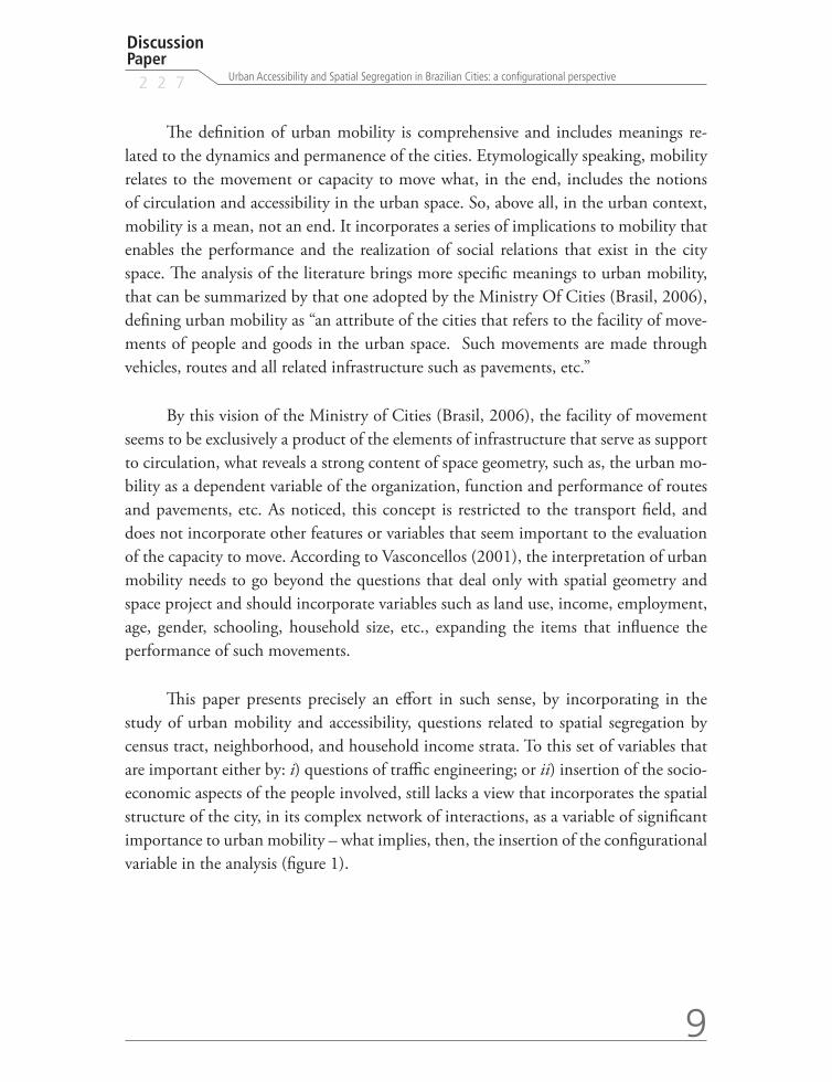
This paper presents precisely an effort in such sense, by incorporating in the study of urban mobility and accessibility, questions related to spatial segregation by census tract, neighborhood, and household income strata. To this set of variables that are important either by: i) questions of traffic engineering; or ii) insertion of the socio-economic aspects of the people involved, still lacks a view that incorporates the spatial structure of the city, in its complex network of interactions, as a variable of significant importance to urban mobility – what implies, then, the insertion of the configurational variable in the analysis (figure 1).
10
B r a s í l i a , O c t u b e r 2 0 1 7
FIGURE 1 Distinct spatial structures generate distinct patterns of movements
Elaborated by the authors.
Obs: above Pelotas-RS and its regular grid in a chess table format; below, Salvador-BA and the significant irregularity of its street network map – the colors represent the
potential movements: red colours means higher integration while blue colours means lower integration.
This first section presented a general introduction about the themes of precarious settlements, spatial structure of cities and urban mobility, in the light of the urbanization process in Brazil. The methodological considerations relative to the space syntax and the procedures adopted in the study are described in section 2. Section 3 presents the pre-liminary results of the research for the four cities selected in the study, besides showing in more detail the case of São Paulo municipality, considering the results of a previous study by one of the authors about the integration values among the neighbourhoods of São Paulo municipality. Last, section 4 presents the main conclusions of the article.

Discussion Paper
2 2 7
11
Urban Accessibility and Spatial Segregation in Brazilian Cities: a configurational perspective
2 METHODOLOGICAL PROCEDURES
2.1 About the theory of the social logic of space
As a theoretical and methodological tool to discuss spatial segregation and road map configuration/form, we have adopted the Theory of the Social Logic of Space, more well-known as space syntax, that investigates the space from the social logic incorpo-rated in it. For this research, it means to say that in the conception of urban space there are implicit (or explicit) social attributes that belong to the society that builds it, ac-cording to a series of expectations, including the ones of circulation.
The objective of the space syntax is to study the relations between the architectonic space – also understood as the urban space – and society – seen as a system of the possibilities of meetings (Holanda, 2002). The creation of this theory, supported by systemic and structural thoughts (Hillier, et al., 1993; Lefebre, 1999), derives from the worry that according to Hillier and Hanson (1997), “the (space) theories had been extremely normative and less analytic”.
We propose that, instead of postulating a formulation and try to fit it in the urban space at any cost, it will be necessary to study the subject till exhaustion, and try to find general properties of its related schemes (Medeiros, 2006). To the authors of this theory, the gradual development of the techniques had convinced them that there is, in the investigation of space, a very important relational property called “configuration” (Hillier and Hanson, 1997). Configuration, therefore, is a basic property found in the relations among city parts (blocks, streets, open spaces, etc.), revealing how different urban layout patterns produce dis-tinguished relational performances. Configuration, based on this point of view, is a complex of interdependency relations in space with two fundamental properties – the configuration is different when seem from: i) different points within the same system; and ii) only from a part of the system. Due to changes in one of the elements of system or in one relation, the entire system can be altered in various degrees. The interpretation of the variations in the con-figuration can reveal attributes derived from the interaction of the space form and different processes associated to circulation, accessibility and urban mobility.
The investigation of these associations can reveal new interpretations about the ur-ban phenomena, bringing information about the movement related questions that occur in the city. About this subject, engineers, architects and urban planners, when looking over the space, several times do not understand that their focus of action surge and is a product of a series of complex relations associating different components. Either the physical objects (buildings, neighborhoods, roads and circulation systems) or these relations are a product of the concept of space and represent properties closely related to their functioning.
12
B r a s í l i a , O c t u b e r 2 0 1 7
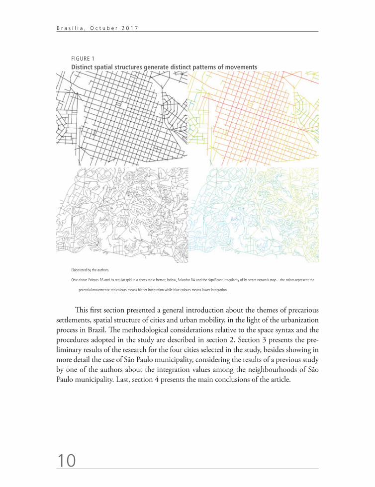
In terms of tools, the space syntax, offers instruments to understand and represent the urban space. Of the recommended strategies, the linear representation is useful to in-vestigate the movement and its related urban aspects and is the one that better applies to big systems and structures such as the city. The linear representation is obtained designing over the road network, from the available cartographic base, the smaller number of possible lines that represent the direct accesses through the urban space. After the processing of such lines, we can generate a matrix of intersections, from where are calculated, by especially programmed applications, values that correspond to their axial inter-relations (Hillier and Hanson, 1984; Hillier, 1996; Holanda 2002; Medeiros, 2006), representing the poten-tial of attraction of the flows and movements of a certain axis within the urban system, called the value or potential of integration, accessibility or permeability. Such values can be represented numerically or by a chromatic scale with graduation going from red, passing through orange, green until reaching blue – where the more integrated axis tend to red and the less integrated to blue – what produces the so called axial map (figure 2).
FIGURE 2
Axial map of the municipality of Belém – Pará
Elaborated by the authors.
Discussion Paper
2 2 7
13
Urban Accessibility and Spatial Segregation in Brazilian Cities: a configurational perspective
The more integrated axis are those more permeable and accessible to the urban space, from where it is easier to reach the others. They imply, on average, the shorter topological ways to be reached from any other axis of the system. More integrated axis tend to assume a position of control, once they can connected themselves to a higher number of axis and hierarchically present a higher potential of integration. To the set of the more integrated axis is given the name of integration core.
From this information, can be inferred that from the procedures that investigate the configuration of the road network of a city, the simulations done by the spatial syn-tax consist of an instrument able to measure, quantify and distinguish different levels of connections between each road and the system where it is inserted, establishing in such way correlations, connections and hierarchy between the roads and the urban complex (Medeiros, 2006). This permits, consequently, the visualization of the road network in several gradations of the potentials of flows and movements, that is, of integration. It be-comes perceptive the definition of areas with a predominance of axis with high potential of movement in opposition to those peripheral areas with less flows. We have, in such way, a valuable tool to study urban mobility by facilitating that factors related to urban configuration can be quantified mathematically and easily visualized and therefore can be correlated with several information that involves movement and circulation.
2.2 Social Data Procedures
After the survey of the information on accessibility of the axial maps (derived from the study by Medeiros, 2006) for i) the urban systems as a whole; ii) the census tracts classi-fied as substandard by IBGE; iii) the census tracts classified as precarious by CEM; and iv) the other urban sectors, the data was compared with information on head of house-hold income in minimum wages, collected at CEM data base. Our objective was, then, to verify what are the most common patterns of spatial segregation, according to GIST and FAVA classification (apud Villaça, 2001) in voluntary segregation (when the individual or the family opts for isolation) and involuntary segregation (when the individual or the family is forced to live in certain areas of the city). All the information was displayed in a GIS software, in order to help the visual and statistical correlation of the variables.
14
B r a s í l i a , O c t u b e r 2 0 1 7
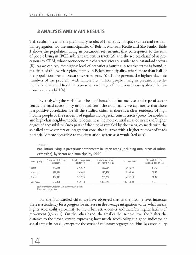
3 ANALYSIS AND MAIN RESULTS
This section presents the preliminary results of Ipea study on space syntax and residen-tial segregation for the municipalities of Belém, Manaus, Recife and São Paulo. Table 1 shows the population living in precarious settlements, that corresponds to the sum of people living in IBGE substandard census tracts (A) and the sectors classified as pre-carious by CEM, whose socioeconomic characteristics are similar to substandard sectors (B). As we can see, the highest level of precarious housing in relative terms is found in the cities of the North region, mainly in Belém municipality, where more than half of the population lives in precarious settlements. São Paulo presents the highest absolute numbers of the problem, with almost 1.5 million people living in precarious settle-ments. Manaus and Recife also present percentage of precarious housing above the na-tional average (14.1%).
By analyzing the variables of head of household income level and type of sector versus the road accessibility originated from the axial maps, we can notice that there is a positive correlation for all the studied cities, as there is a clear tendency of high income people or the residents of regular/ non-special census tracts (proxy for medium and high class neighborhoods) to locate near the more central areas or in areas of higher degree of accessibility. Such parts of the city, as revealed by the maps, coincide with the so called active centers or integration core, that is, areas with a higher number of roads potentially more accessible to the circulation system as a whole (red axis).
TABLE 1 Population living in precarious settlements in urban areas (including rural areas of urban extension), by sector and municipality- 2000
MunicipalityPeople in substandard
sectors (A)People in precarious
sectors (B)People in precarious settlements (A + B)
Total population% people living in
precarious settlements
Belém 447,915 205,039 652,954 1,268,230 51.49
Manaus 166,870 193,006 359,876 1,389,892 25.89
Recife 134,317 121,990 256,307 1,413,119 18.14
São Paulo 902,490 557,158 1,459,648 10,215,800 14.29
Source: CEM (2007), based on IBGE 2000 Census microdata. Elaborated by the authors.
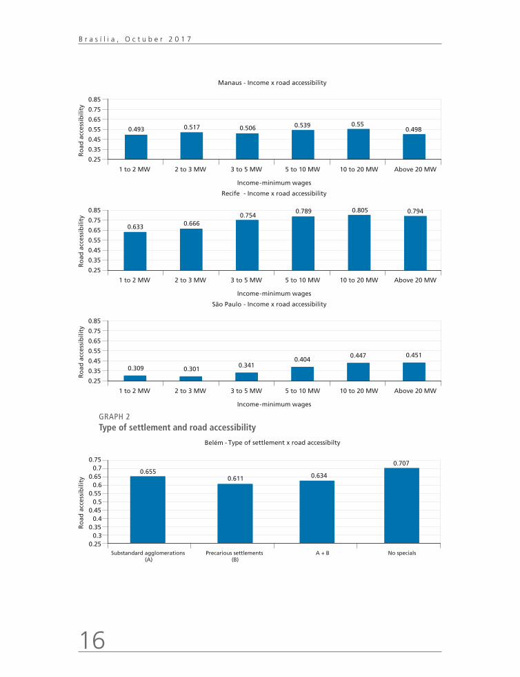
For the four studied cities, we have observed that as the income level increases there is a tendency for a progressive increase in the average integration value, what means higher accessibility/proximity to the urban active center and therefore higher facility of movement (graph 1). On the other hand, the smaller the income level the higher the distance to the urban center, expressing how much accessibility is a good indicator of social status in Brazil, except for the cases of voluntary segregation. Finally, accessibility

Discussion Paper
2 2 7
15
Urban Accessibility and Spatial Segregation in Brazilian Cities: a configurational perspective
is a good that is positively incorporated, especially by the real estate market and that is reflected in the price of housing.
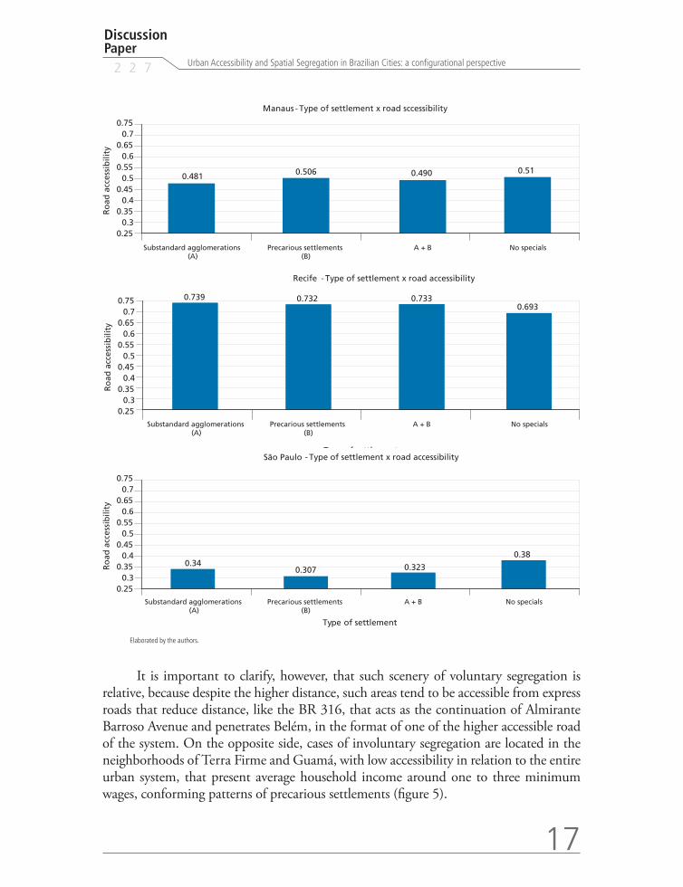
When we observe the average degree of integration for CEM precarious tracts (proxy for peripheral allotments) and IBGE substandard sectors (proxy for slums) in relation to the averages for the regular/non-special sectors (proxy for medium and high income neighborhoods) and for the city as a whole (figure 4), except for Recife, where the location pattern of precarious settlements is relatively more central, it is perceptive how much these spaces related to precarious settlement belonging to A and B groups are less accessible and present lower integration averages, except when located near the city center, in marginal areas with high level of inclination/slope and river and lakesides, mainly. On average, in general, the IBGE substandard sectors present more central locations when compared to CEM precarious sectors, reaffirming the results of other studies on the subject, that argue that the population living in slums search for locations near employment centers (Morais et al., 2003).
In Belém, for instance, the study confirms that medium and high income classes (head of household income above twenty minimum wages) are located in the noble areas of the city (Nazaré and Batista Campos neighborhoods), located near the integration core (figures 5 and 6). Even in smaller scale, there are also sectors of closed condominiums, with high household income level, located in peripheral areas such as Parque Verde neigh-borhood, what represents the scenery of voluntary segregation in the so called fortified enclaves or gated communities, as Caldeira (2000) defines.
GRAPH 1 Average head of household income and road accessibility(In minimum wages)
0.25
0.35
0.45
0.55
0.65
0.75
0.5520.635
0.719 0.742 0.757 0.7780.85
1 to 2 MW 2 to 3 MW 3 to 5 MW 5 to 10 MW 10 to 20 MW Above 20 MW
Ro
ad a
cces
sib
ility
Income -minimum wages
Belém - Income x road accessibility
16
B r a s í l i a , O c t u b e r 2 0 1 7
0.25
0.35
0.45
0.55 0.493 0.517 0.506 0.539 0.550.498
0.65
0.75
0.85
1 to 2 MW 2 to 3 MW 3 to 5 MW 5 to 10 MW 10 to 20 MW Above 20 MW
Ro
ad a
cces
sib
ility
Income -minimum wages
Manaus - Income x road accessibility
Recife
0.25
0.35
0.45
0.55
0.65 0.633 0.6660.754
0.789 0.805 0.7940.75
0.85
1 to 2 MW 2 to 3 MW 3 to 5 MW 5 to 10 MW 10 to 20 MW Above 20 MW
Ro
ad a
cces
sib
ility
Income -minimum wages
- Income x road accessibility
0.309 0.301 0.3410.404
0.447 0.451
0.25
0.35
0.45
0.55
0.65
0.75
0.85
1 to 2 MW 2 to 3 MW 3 to 5 MW 5 to 10 MW 10 to 20 MW Above 20 MW
Ro
ad a
cces
sib
ility
Income -minimum wages
São Paulo - Income x road accessibility
GRAPH 2Type of settlement and road accessibility
0.250.3
0.350.4
0.450.5
0.550.6
0.650.655
0.611 0.634
0.7070.7
0.75
Substandard agglomerations(A)
Precarious settlements (B)
A + B No specials
Type of settlement
Ro
ad a
cces
sib
ility
Belém Type of settlement x road accessibilty -
Discussion Paper
2 2 7
17
Urban Accessibility and Spatial Segregation in Brazilian Cities: a configurational perspective
0.250.3
0.350.4
0.450.5
0.550.6
0.650.7
0.75
0.481 0.506 0.490 0.51
Substandard agglomerations(A)
Precarious settlements (B)
A + B No specials
0.340.307 0.323
0.38
Type of settlement
Ro
ad a
cces
sib
ility
Manaus Type of settlement x road sccessibility -
0.6550.611 0.634
0.250.3
0.350.4
0.450.5
0.550.6
0.650.7
0.75 0.739 0.732 0.7330.693
Substandard agglomerations(A)
Precarious settlements (B)
A + B No specials
Recife Type of settlement x road accessibility
Type of settlement
Ro
ad a
cces
sib
ility
-
0.25
0.340.307 0.323
0.38
0.30.35
0.40.45
0.50.55
0.60.65
0.70.75
Substandard agglomerations(A)
Precarious settlements (B)
A + B No specials
Type of settlement
Ro
ad a
cces
sib
ility
São Paulo Type of settlement x road accessibility -
Elaborated by the authors.
It is important to clarify, however, that such scenery of voluntary segregation is relative, because despite the higher distance, such areas tend to be accessible from express roads that reduce distance, like the BR 316, that acts as the continuation of Almirante Barroso Avenue and penetrates Belém, in the format of one of the higher accessible road of the system. On the opposite side, cases of involuntary segregation are located in the neighborhoods of Terra Firme and Guamá, with low accessibility in relation to the entire urban system, that present average household income around one to three minimum wages, conforming patterns of precarious settlements (figure 5).

18
B r a s í l i a , O c t u b e r 2 0 1 7
FIGURE 3 Belém: average income of the head of household (In minimum wages)
Elaborated by the authors.
FIGURE 4Belém: axial map
Elaborated by the authors.
Discussion Paper
2 2 7
19
Urban Accessibility and Spatial Segregation in Brazilian Cities: a configurational perspective
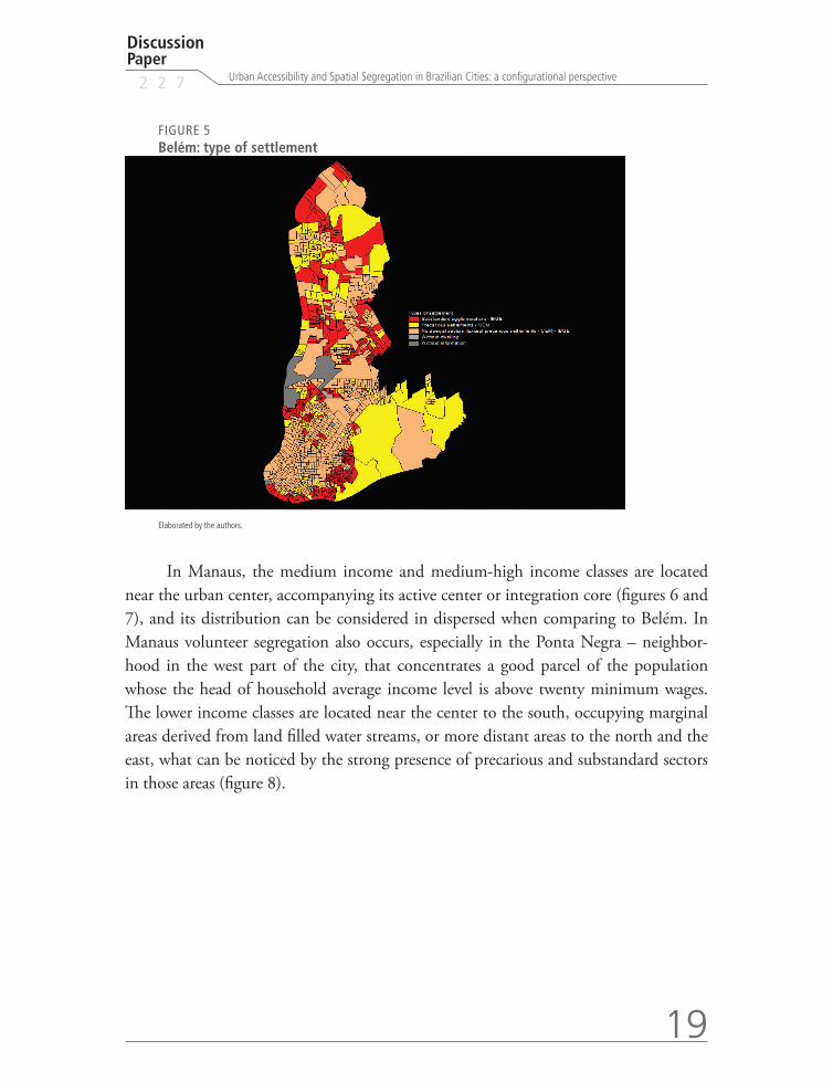
FIGURE 5Belém: type of settlement
Elaborated by the authors.
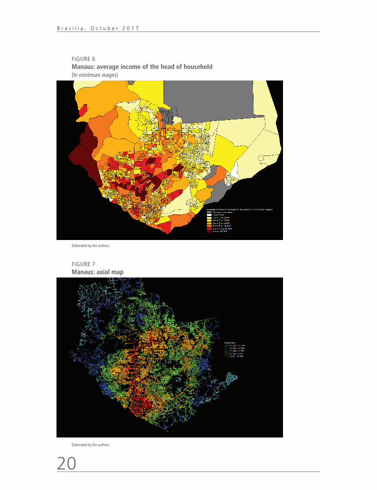
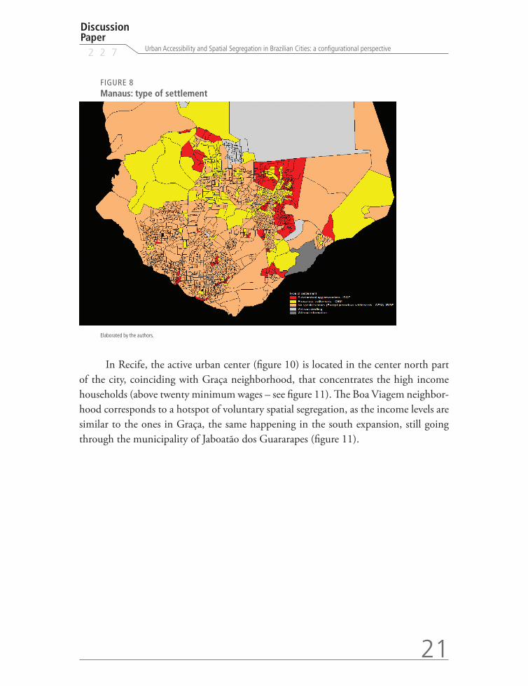
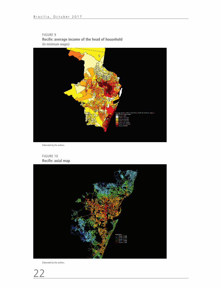
In Manaus, the medium income and medium-high income classes are located near the urban center, accompanying its active center or integration core (figures 6 and 7), and its distribution can be considered in dispersed when comparing to Belém. In Manaus volunteer segregation also occurs, especially in the Ponta Negra – neighbor-hood in the west part of the city, that concentrates a good parcel of the population whose the head of household average income level is above twenty minimum wages. The lower income classes are located near the center to the south, occupying marginal areas derived from land filled water streams, or more distant areas to the north and the east, what can be noticed by the strong presence of precarious and substandard sectors in those areas (figure 8).
20
B r a s í l i a , O c t u b e r 2 0 1 7
FIGURE 6 Manaus: average income of the head of household(In minimum wages)
Elaborated by the authors.
FIGURE 7 Manaus: axial map
Elaborated by the authors.
Discussion Paper
2 2 7
21
Urban Accessibility and Spatial Segregation in Brazilian Cities: a configurational perspective
FIGURE 8 Manaus: type of settlement
Elaborated by the authors.
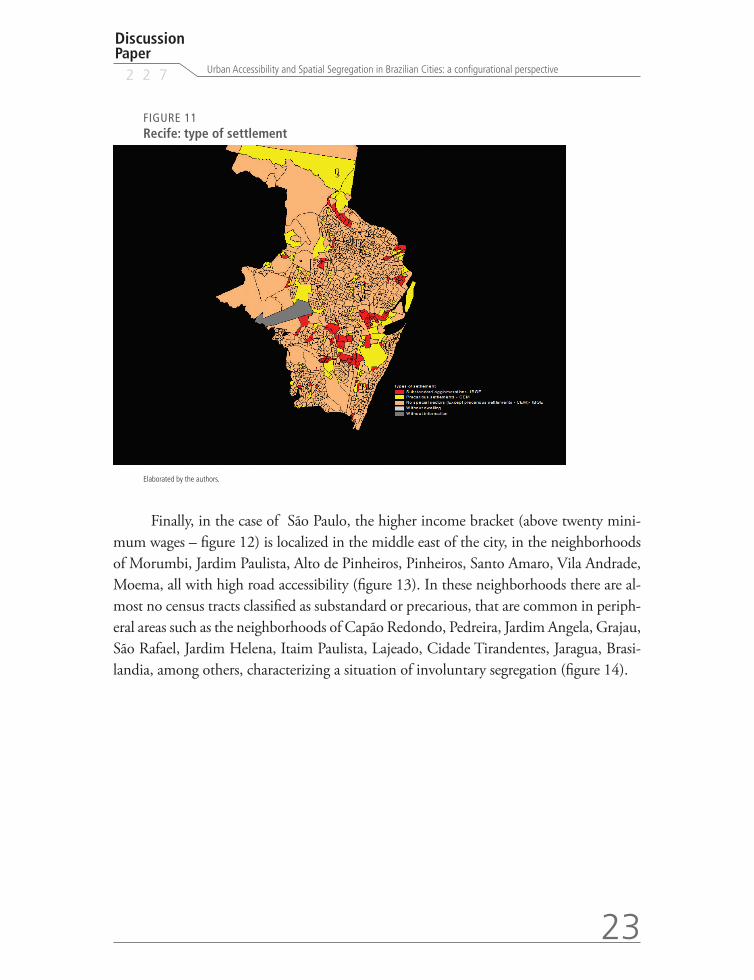
In Recife, the active urban center (figure 10) is located in the center north part of the city, coinciding with Graça neighborhood, that concentrates the high income households (above twenty minimum wages – see figure 11). The Boa Viagem neighbor-hood corresponds to a hotspot of voluntary spatial segregation, as the income levels are similar to the ones in Graça, the same happening in the south expansion, still going through the municipality of Jaboatão dos Guararapes (figure 11).
22
B r a s í l i a , O c t u b e r 2 0 1 7
FIGURE 9 Recife: average income of the head of household (In minimum wages)
Elaborated by the authors.
FIGURE 10 Recife: axial map
Elaborated by the authors.
Discussion Paper
2 2 7
23
Urban Accessibility and Spatial Segregation in Brazilian Cities: a configurational perspective
FIGURE 11Recife: type of settlement
Elaborated by the authors.
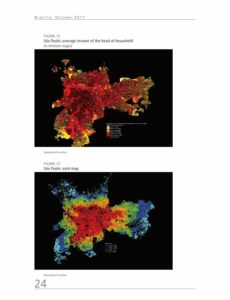
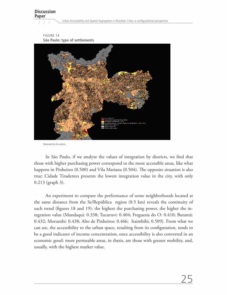
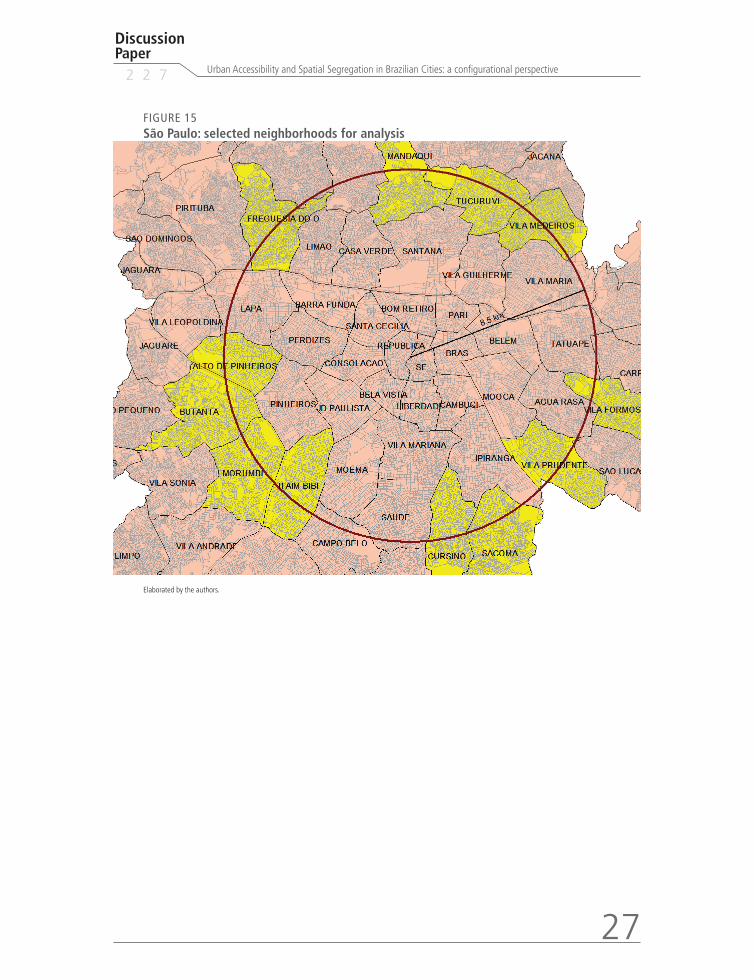
Finally, in the case of São Paulo, the higher income bracket (above twenty mini-mum wages – figure 12) is localized in the middle east of the city, in the neighborhoods of Morumbi, Jardim Paulista, Alto de Pinheiros, Pinheiros, Santo Amaro, Vila Andrade, Moema, all with high road accessibility (figure 13). In these neighborhoods there are al-most no census tracts classified as substandard or precarious, that are common in periph-eral areas such as the neighborhoods of Capão Redondo, Pedreira, Jardim Angela, Grajau, São Rafael, Jardim Helena, Itaim Paulista, Lajeado, Cidade Tirandentes, Jaragua, Brasi-landia, among others, characterizing a situation of involuntary segregation (figure 14).
24
B r a s í l i a , O c t u b e r 2 0 1 7
FIGURE 12 São Paulo: average income of the head of household (In minimum wages)
Elaborated by the authors.
FIGURE 13 São Paulo: axial map
Elaborated by the authors.
Discussion Paper
2 2 7
25
Urban Accessibility and Spatial Segregation in Brazilian Cities: a configurational perspective
FIGURE 14 São Paulo: type of settlements
Elaborated by the authors.
In São Paulo, if we analyze the values of integration by districts, we find that those with higher purchasing power correspond to the more accessible areas, like what happens in Pinheiros (0.500) and Vila Mariana (0.504). The opposite situation is also true: Cidade Tiradentes presents the lowest integration value in the city, with only 0.213 (graph 3).
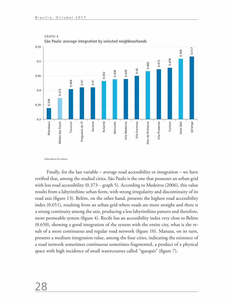
An experiment to compare the performance of some neighborhoods located at the same distance from the Se/República region (8.5 km) reveals the continuity of such trend (figures 18 and 19): the highest the purchasing power, the higher the in-tegration value (Mandaqui: 0.338; Tucuruvi: 0.404; Freguesia do O: 0.410; Butantã: 0.432; Morumbi: 0.438; Alto de Pinheiros: 0.466; Itaimbibi; 0.509). From what we can see, the accessibility to the urban space, resulting from its configuration, tends to be a good indicator of income concentration, once accessibility is also converted in an economic good: more permeable areas, in thesis, are those with greater mobility, and, usually, with the highest market value.

26
B r a s í l i a , O c t u b e r 2 0 1 7
GRAPH 3
São Paulo: road accessibility value of integration by district0.
213
0.26
3
0.26
8
0.28
7
0.29 0.
303
0.30
9
0.31
7
0.32
6
0.33
3
0.33
6
0.35
2
0.36
2
0.37
3
0.38
8
0.38
9
0.39
7
0.39
8
0.40
6
0.42
3
0.43
7
0.44
5
0.44
9
0.45
3
0.45
4
0.45
9
0.5 0.50
4
0.51
4
0.53
3
0.2
0.25
0.3
0.35
0.4
0.45
0.5
0.55
Cid
ade
Tira
den
tes
Gu
aian
ases
Peru
s
Itai
m P
aulis
ta
M´B
oi M
irim
Cam
po
Lim
po
São
Mat
eus
Trem
emb
é/Ja
çan
ã
Cid
ade
Ad
emar
Piri
tub
a
São
Mig
uel
Itaq
uer
a
Freg
ues
ia/B
rasi
lân
dia
Méd
ia S
ão P
aulo
Cas
a V
erd
e/C
ach
oei
rin
ha
Bu
tan
tã
San
tan
a/Tu
curu
vi
Erm
elin
o M
atar
azzo
Vila
Pru
den
te/S
apo
pem
ba
Jab
aqu
ara
Pen
ha
San
to A
mar
o
Ipir
ang
a
Lap
a
Vila
Mar
ia/V
ila G
uilh
erm
e
Ari
can
du
va
Pin
hei
ros
Vila
Mar
ian
a
Mo
oca Sé
Elaborated by the authors.
Discussion Paper
2 2 7
27
Urban Accessibility and Spatial Segregation in Brazilian Cities: a configurational perspective
FIGURE 15 São Paulo: selected neighborhoods for analysis
Elaborated by the authors.
28
B r a s í l i a , O c t u b e r 2 0 1 7
GRAPH 4 São Paulo: average integration by selected neighbourhoods
0.33
8
0.37
3
0.40
4
0.41
0.41
0.43
2
0.43
8
0.43
9
0.45
0.46
6
0.47
3
0.47
8
0.50
9
0.51
7
0.3
0.35
0.4
0.45
0.5
0.55M
and
aqu
i
Méd
ia S
ão P
aulo
Tucu
ruvi
Freg
ues
ia d
o Ó
Saco
ma
Bu
tan
tã
Mo
rum
bi
Vila
Med
eiro
s
Vila
Fo
rmo
sa
Alt
o d
e Pi
nh
eiro
s
Vila
Pru
den
te
Cu
rsin
o
Itai
m B
ibi
Ipir
ang
a
Elaborated by the authors.
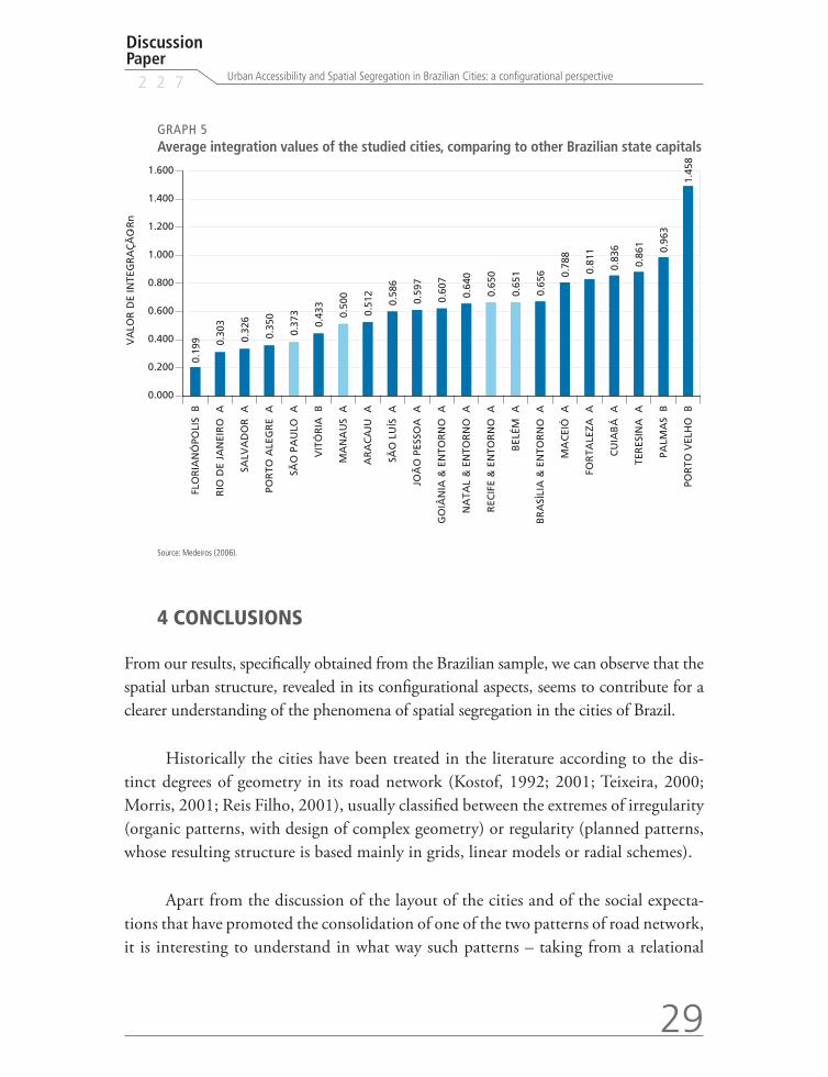
Finally, for the last variable – average road accessibility or integration – we have verified that, among the studied cities, São Paulo is the one that possesses an urban grid with less road accessibility (0.373 – graph 5). According to Medeiros (2006), this value results from a labyrinthine urban form, with strong irregularity and discontinuity of its road axis (figure 13). Belém, on the other hand, presents the highest road accessibility index (0.651), resulting from an urban grid where roads are more straight and there is a strong continuity among the axis, producing a less labyrinthine pattern and therefore, more permeable system (figure 4). Recife has an accessibility index very close to Belém (0.650), showing a good integration of the system with the entire city, what is the re-sult of a more continuous and regular road network (figure 10). Manaus, on its turn, presents a medium integration value, among the four cities, indicating the existence of a road network sometimes continuous sometimes fragmented, a product of a physical space with high incidence of small watercourses called “igarapés” (figure 7).
Discussion Paper
2 2 7
29
Urban Accessibility and Spatial Segregation in Brazilian Cities: a configurational perspective
GRAPH 5 Average integration values of the studied cities, comparing to other Brazilian state capitals
0.19
9 0.30
3
0.32
6
0.35
0
0.37
3
0.43
3
0.50
0
0.51
2
0.58
6
0.59
7
0.60
7
0.64
0
0.65
0
0.65
1
0.65
6 0.78
8
0.81
1
0.83
6
0.86
1 0.96
3
1.45
8
0.000
0.200
0.400
0.600
0.800
1.000
1.200
1.400
1.600
FLO
RIA
NÓ
POLI
S B
RIO
DE
JAN
EIR
O A
SALV
AD
OR
A
POR
TO A
LEG
RE
A
SÃO
PA
ULO
A
VIT
ÓR
IA B
MA
NA
US
A
AR
AC
AJU
A
SÃO
LU
ÍS A
JOÃ
O P
ESSO
A A
GO
IÂN
IA &
EN
TOR
NO
A
NA
TAL
& E
NTO
RN
O A
REC
IFE
& E
NTO
RN
O A
BEL
ÉM A
BR
ASÌ
LIA
& E
NTO
RN
O A
MA
CEI
Ó A
FOR
TALE
ZA A
CU
IAB
Á A
TER
ESIN
A A
PALM
AS
B
POR
TO V
ELH
O B
VA
LOR
DE
INTE
GR
AÇ
ÃO
-Rn
Source: Medeiros (2006).
4 CONCLUSIONS
From our results, specifically obtained from the Brazilian sample, we can observe that the spatial urban structure, revealed in its configurational aspects, seems to contribute for a clearer understanding of the phenomena of spatial segregation in the cities of Brazil.
Historically the cities have been treated in the literature according to the dis-tinct degrees of geometry in its road network (Kostof, 1992; 2001; Teixeira, 2000; Morris, 2001; Reis Filho, 2001), usually classified between the extremes of irregularity (organic patterns, with design of complex geometry) or regularity (planned patterns, whose resulting structure is based mainly in grids, linear models or radial schemes).
Apart from the discussion of the layout of the cities and of the social expecta-tions that have promoted the consolidation of one of the two patterns of road network, it is interesting to understand in what way such patterns – taking from a relational
30
B r a s í l i a , O c t u b e r 2 0 1 7
point of view, that is, in the relation of interdependence between all the component parts of the system – affect the urban accessibility in cities, according to the distinct composition of its spatial structure. It means to observe how the layout of the compo-nents of the circulation system (patterns of the circulation structures related to road design, forms of connections, existence of nodes, the size of the links, the high or low density of the roads, etc.) interferes in mobility, resulting in restrictions or enabling conditions for road accessibility. It has a direct impact on the aspects of the spatial segregation of social classes in space, as confirmed by our results, where the low in-come populations or the residents of precarious settlements have lower levels of urban mobility and, therefore, less access to the entire urban system, what represents a deny in their human right to the city.
We conclude, then, that the configurational approach verified by the use of axial maps, contributed to the study of spatial segregation and urban mobility in the four studied cities, showing that the configuration of the road network is a relevant aspect to explain some of the urban problems related to social apartheid/inclusion and physi-cal segregation /accessibility in the Brazilian cities. It happens that the spatial hierarchy depends directly on the modes of relationship among the different components of the circulation system, in their various degrees of regularity or irregularity in what regards to its spatial structure, what tends to be one of the most robust expressions of the dis-tribution of social classes in the city.
REFERENCES
BARROS, A. P. B. G.; MEDEIROS, V. A. S.; MORAIS, M. P. A. Configuração espacial para o diagnóstico dos assentamentos precários no Brasil. In: ENCONTRO ANUAL DA ANPOCS, 33., 2009, Caxambu, Minas Gerais. Anais... São Paulo: Anpocs, 2009. v. 1.
______. Spatial segregation and urban accessibility in Brazilian cities. In: ANNUAL CON-FERENCE ON PLANNING RESEARCH, 3., 2010, Porto, Portugal: Universidade do Porto, 2010a.
______. A new issue for transport mobility and spatial segregation agenda: the configurational focus. In: WORLD CONFERENCE ON TRANSPORT RESEARCH SOCIETY, 12., 2010, Lisboa. Portugal: Instituto Superior Técnico, 2010b.
______. A configuração espacial para o diagnóstico dos assentamentos precários no Brasil. In: MORAIS, M.P.; KRAUSE, C.; LIMA NETO, V. C. Caracterização e tipologia de assenta-mentos precários: estudos de caso brasileiros. Brasília: Ipea, 2016.
Discussion Paper
2 2 7
31
Urban Accessibility and Spatial Segregation in Brazilian Cities: a configurational perspective
BRASIL. Ministério das Cidades. Brasil acessível – Caderno 2. Brasília: Secretaria Nacional de Transporte e da Mobilidade Urbana. 2006.
______. Ministério das Cidades/ Secretaria Nacional de Habitação. Política Habitacional e a Integração Urbana de Assentamentos Precários: Parâmetros conceituais, técnicos e metodo-lógicos. (2ª reimpressão) Brasília: Ministério das Cidades. 2008.
CALDEIRA, T. Cidade de muros – crime, segregação e cidadania em São Paulo. Editora 34/EdUsp: São Paulo, 2000.
FERREIRA, M. P. et al. Uma metodologia para a estimação de assentamentos precários em ní-vel nacioanal In: BRASIL. Ministério das Cidades/Secretaria Nacional de Habitação. Política Habitacional e a Integração Urbana de Assentamentos Precários: parâmetros conceituais, técnicos e metodológicos. (2ª reimpressão) Brasília: Ministério das Cidades, 2008.
HILLIER, B. et al. Natural movement: or, configuration and attraction in urban pedestrian movement. Environment and Planning B, Londres: Pion Publication, 1993.
______. Space is the machine. Londres: CUP, 1996.
HILLIER, B.; HANSON, J. The reasoning art. In: 1st International Space Syntax Symposium 1997. Proceedings… Londres: SSL/UCL, 1997.
______. The social logic of space. Cambridge Press: Cambridge, 1984.
HOLANDA, F. O espaço de exceção. Brasília: Editora UnB, 2002.
HOLANDA, F. et al. Brasilia, Brazil: economic and social costs of dispersion. In: 44th. ISOCARP Congress, 2008. Proceedings… Dalian: ISCRP/UPSC. 2008.
IBGE – INSTITUTO BRASILEIRO DE GEOGRAFIA E ESTATÍSTICA. Censo Demográ-fico 2000: agregado por setores censitários dos resultados do universo. 2. ed. Rio de Janeiro: IBGE, 2003.
KOSTOF, S. The city assembled. Londres: Thames and Hudson, 1992.
______. The city shaped. Londres: Thames and Hudson, 2001.
LEFEBVRE, H. Writings on cities. Oxford: Blackwell, 1999.
MARQUES, E. et al. Assentamentos precários no Brasil urbano. Centro de Estudos da Metrópole/CEBRAP; Secretaria Nacional de Habitação; Ministério das Cidades, 2007. Disponível em: <http://www.centrodametropole.org.br/mc/assets/pdfs/assentamentos_web.pdf>. Acesso em: 20 Sep. 2009.
MEDEIROS, V. Urbis brasiliae ou sobre cidades do Brasil. 2006. Tese (Doutorado) – Faculdade de Arquitetura e Urbanismo; Universidade de Brasília, Brasília, 2006.
MORAIS, M. P. et al. Residential segregation and social exclusion in brazilian housing markets. Brasília: Ipea, 2003. (Texto para Discussão, n. 951).
32
B r a s í l i a , O c t u b e r 2 0 1 7
MORRIS, A. Historia de la forma urbana. Barcelona: GG, 2001.
REIS FILHO, N. Evolução urbana do Brasil 1500/1720. São Paulo: Pini, 2001.
ROLNIK, R. O que é cidade. São Paulo: Brasiliense, 1998.
SANTOS, M. A urbanização brasileira. São Paulo: Editora da USP, 2005.
TEIXEIRA, M. Imagens do arquivo virtual da cartografia urbana portuguesa. Lisboa: CEUA/ISCT, 2000.
TRIGUEIRO, E. B. F. et al. Disneyfication now?: assessing spatial correlates for heritage preserva-tion in Natal, Brazil. In: Space Syntax 3rd International Symposium. 2001, Atlanta, Proceedings… Atlanta: Georgia Institute of Technology, 2001.
VASCONCELOS, E. Transporte urbano, espaço e equidade. São Paulo: Annablume.
VILLAÇA, F. Espaço intra-urbano no Brasil. São Paulo: Nobel, 2001.

Ipea – Institute for Applied Economic Research
Press and Communications Office
PUBLISHING DEPARTMENT
CoordinationCláudio Passos de Oliveira
SupervisionEverson da Silva Moura
TypesettingBernar José VieiraCristiano Ferreira de AraújoDanilo Leite de Macedo TavaresHerllyson da Silva SouzaJeovah Herculano Szervinsk JuniorLeonardo Hideki Higa
Cover designDanielle de Oliveira AyresFlaviane Dias de Sant’ana
Graphic designRenato Rodrigues Buenos
The manuscripts in languages other than Portuguese published herein have not been proofread.
Ipea BookstoreSBS – Quadra 1 − Bloco J − Ed. BNDES, Térreo 70076-900 − Brasília – DF – BrazilTel.: + 55 (61) 2026 5336Email: [email protected]


Composed in Adobe Garamond 11/13.2 (text)Frutiger 47 (headings, graphs and tables)
Brasília – DF – Brazil

Ipea’s missionEnhance public policies that are essential to Brazilian developmentby producing and disseminating knowledge and by advisingthe state in its strategic decisions.