
Types of Slope Movement and Instabilities · 2019-04-17 · • Identify the factors that drive...
79
Types of Slope Movement and Instabilities
Transcript of Types of Slope Movement and Instabilities · 2019-04-17 · • Identify the factors that drive...

Types of Slope Movement and Instabilities

Learning Objectives
• Identify different characteristics and classifications of landslides.• Identify the factors that drive landslides.• Identify different types of slopes and the factors that make them
susceptible to failure. • Understand techniques that aid in identification of landslide
features in the field.

What is a Landslide?
• A general term for a wide variety of processes and landforms involving the downslope movement, under gravity, of masses of soil and rock material.
• Variety of landslide types, driven by different processes and geologic history.
• Classification of landslides often defined by failure mechanism, speed of movement, and geologic material.
• Different landslides require different mitigation and planning considerations.

Types of Movement
• Creep• Surficial Creep• Massive Creep
• Instability• Slides • Flows• Falls/Toppling
• Settlement• Embankment• Foundation

Types of Landslides

Classification

Terminology
Principal Slope, Escarpment, Headscarp
Tension Cracking in Accordance with the Shape of the Failure
Crest
Flank
Bottom
Toe
Head Cracks
Body Surface
Comparable to a Circle Arc

Surficial Creep
Possible Terracing
Possible Cracking
Direction of Growth of Trees Affected by Creep
Natural Direction of Growth of Trees
Possible Distribution of the Rate of Movement in the Hillside

What is happening
here?

What causes creep?
• Weather and climate cycling.• Freeze/thaw.• Expansion/contraction.• Temporary exposure to weakened conditions (i.e. wildfire/timber
harvest)• Characteristics:
• Bowed trees, tilting fence posts, compression ridges, hummocky terrain.
• Tension cracks.


Translational Slides
Cracking


What causes translational geometry?
• Bedding planes, weak seams and geology dictate failure geometry.
• Tendency to exhibit only displacement at failure with limited settlement/heave in body.
• Headscarp tends to be less curved.• Characteristics:
• Relatively shallow depth of failure – wide and long geometry with respect to depth.
• Clear failure at transition between subsurface materials.• Tends to occur in gentle terrain.

Rotational Slides
RO
R
Soft SoilFirm Stratum


What causes rotational geometry?
• Weak soils.• Tensile strength and/or presence of cohesion.• Relatively uniform soil deposits.• Low mobilized friction.• Gentle slope geometry.• Characteristics:
• Curvilinear shape, particularly at headscarp.• Concave rupture shape in plan view.• Rotation of body – settlement

Transition from Cut to Fill Failure


Flows


What causes flows?
• Large buildup of water.• Presence of loosely deposited, unstable sediment. • Contraction of debris during shear.• Steep, channelized downslope terrain.• Characteristics:
• Fluidization of debris. • Fast/long travel of debris. • Tendency to occur in gullys, ravines and seasonal stream channels.• Cirques or “headwall” morphology in catchment.

FALLS/TOPPLING
Initial Toppling or Sliding
Bouncing
Joints
Scree or Talus
Tension Crack
Sliding / Rolling


What causes rockfalls?
• Freeze/thaw and heavy precipitation.• Weathering rates, especially prevalent in fresh rockslopes. • Geologic characteristics, such as fractures, joints, dips, bedding
planes.• Characteristics:
• Debris is primarily rock or lithified soil.• Most rapidly occurring at overhangs and seeps.• Tends to retrogress in fractured sections.

Settlement/Compound Embankment Failure
SandSoft Clay
Sand & Gravel


Combined Stability and Settlement

What causes embankment failures?
• Soft soils, particularly clay underlying embankment.• Rapid loading, buildup of excess porewater pressure.• Settlement and eventually excessive shear softening and
failure.• Characteristics:
• Squeeze or heave at the toe of the slope.• Uneven settlement in centerline of embankment, lateral movement of
edges.

Time for a quiz!
• Name the type of failure. • Discuss possible causes.• Assess the kinematics.


Identifying Landslide Features and Landslide
Investigation

Learning Objectives
• Understand common features of landslides.• Understand what ground distress might signal.• Identify conventional techniques for monitoring landslides.

LANDSLIDE INVESTIGATION
• OBJECTIVE: Correctly identify cause for the instability and develop corrective measures that are appropriate for the remediation.
LANDSLIDE INVESTIGATION
• Step 1 – Preliminary Desk Study• Geology• Topography• Site History• Landslide History• Rainfall distribution
• Step II – Site Reconnaissance• Inspection of landslide• Landslide features• Landslide dimensions

B
6
B
A
A
5
43
7
71 2
Dimensions
1 Width of displaced mass
2 Width of surface of rupture
3 Length of displaced mass
4 Length of surface of rupture
5 Depth of displaced mass
6 Depth of surface of rupture
7 Total length

Landslide Volume
VOL ≈ 1/6 (π Dr WrLr )
Dr = Depth of Rupture Surface (#6)Wr = Width of Rupture Surface (#2)Lr = Length of Rupture Surface (#4)
VOLswell ≈ 4/3 VOL = 2/9 (π Dr Wr Lr )


LANDSLIDE INVESTIGATION• Step II - Site Reconnaissance (Surface Investigation)
(cont)• Equipment Needed to Access Site• Observe condition of existing slopes• Condition of existing vegetation• Groundwater seeps, streams, ponds, etc.• Geologic formations• From site reconnaissance develop list of potential causes of
failure and potential mode of failure• Create a subsurface model, then drill to confirm!

Estimating Shear Surface Geometry
Headscarp
Projection Angle of Scarp Toe
Projection Angle of Toe
?

LANDSLIDE INVESTIGATION
• Step III – Field Investigation (Subsurface)• Area of investigation• Depth of investigation• Duration of investigation• SPT & CPT tests• Surface-based geophysical methods

LANDSLIDE INVESTIGATION
What types of measurements are important in evaluating a landslide?
• Magnitude of movement, velocity, acceleration and shape of sliding mass.
• Pore water pressures.

LANDSLIDE INVESTIGATION
• Step IV - Field Instrumentation - Surface Measurement• Conventional surveying equipment• Differential global positioning system• LiDAR (Laser illuminated detection and ranging)• InSAR (Interferometric synthetic aperture radar)• In-situ Instrumentation
• Inclinometers/Extensometers• Piezoemeters• GPS/GNSS

LANDSLIDE INVESTIGATION• Step IV - Field Instrumentation - Ground Displacement
Measurement• Inclinometers

Confirming Shear Surface Geometry
Headscarp
Toe
Boring and Inclinometer
Boring and Inclinometer


LANDSLIDE INVESTIGATION• Step IV - Field Instrumentation - Ground Displacement
Measurement • Extensometers

LANDSLIDE INVESTIGATION• Step IV - Field Instrumentation
• Piezometers

GPS/GNSS-RTK
• Place survey monuments on landslide mass.• Collect repeat collection of GPS location over time. • Better supplemented with survey control (total station, etc.)

Inverse Velocity Prediction of Failure
• Measure landslide velocity, v, for a given set of time increments.
• Plot 1/v vs. time, check the projected intersection(s) of inverse velocity trajectory and x-axis (time). This intersection is the expected time of failure.

Field Methods
• More qualitative.• Essential for initial landslide investigation and important for
ongoing landslide monitoring.• Often, ground distress can be difficult to measure, so
supplementing field observations with quantitative monitoring efforts are important.
• However, there are several important signals that can be useful.

The Truth is in the Trees…
• Bowed or distorted trees (e.g. “pistol butting”, “drunken trees”) are a sign of distress, either recent or in the past.
• Limited to conifers that tend to grow straight.• Sometimes false positives may cause this:
• Snow levels.• Surficial soil creep.• Location on a steep but competent slope (e.g. cutslopes, cliffs).
• Location of bow might be reflective of timing.


Split Stumps –needle in the haystack…
• Upon significant shear or ground deformation, stumps or even live trees might be sheared apart.
• Difficult to find, not always found in landslide deposits.• However, this is a good indicator of how recent landslide activity
is.• Easiest to find in large, old growth stumps.• Example: If stumps or trees from the last rotation are sheared,
but the current trees are not, significant movement occurred between the last and current rotation.


Ground Distress
• Recent landslide activity often exhibits ground distress, exposing mineral soil in locations, commonly in the form of:
• Tension cracks (Slide Headscarp, Flanks, Body, Upslope Terrain)• Compression blocks/steps (Slide Body, Toe)• Ground subsidence (Slide Graben/Headscarp)• Surface heave (Slide Body/Toe)

Tension Cracks
• Widely variable in size.• The wider, the more worrisome.• Direct conduit for rainfall…

Compression Blocks
• As the slide moves downslope, it puts blocks of soil and rock in compression.
• Often manifests as compression blocks or “steps.”• These steps might be more than a few feet in height.
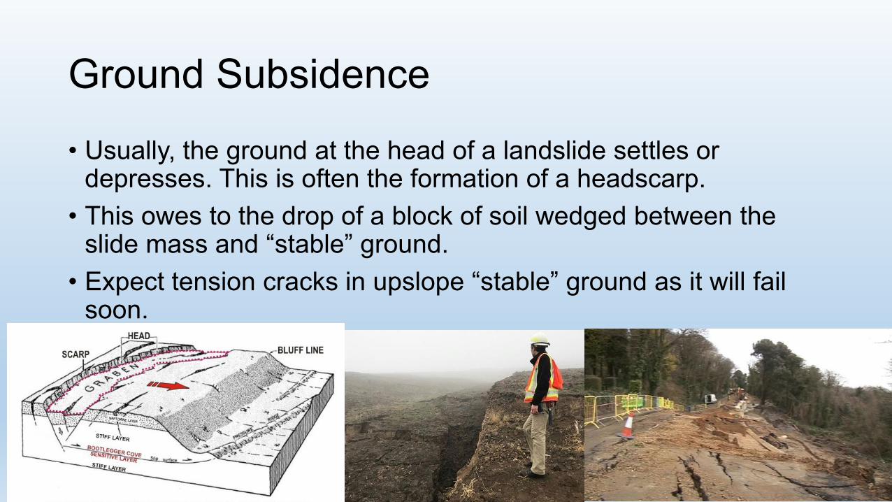
Ground Subsidence
• Usually, the ground at the head of a landslide settles or depresses. This is often the formation of a headscarp.
• This owes to the drop of a block of soil wedged between the slide mass and “stable” ground.
• Expect tension cracks in upslope “stable” ground as it will fail soon.

Surface Heave• Throughout the body of a
landslide and especially the slide toe, surface heave might occur from the upward movement of material along a slide plane. (Pressure ridge)
• Manifests as a rather gentle toe in comparison to the rest of the toe.
• Often results in churned, unstable soil at lower inflection of slide mass.

Hummocky Terrain
• Common identifier for unstable terrain, either now or in the past.• Catastrophic landslides (“fast-moving”) deposit landslide debris
in an uneven, undulating fashion.• Slow-moving slides often see significant distress throughout
body, results in uneven terrain that weathers over time.• Tell-tales: sagponds/strange puddles, oddly-placed boulders,
tortuous creeks through terrain.• In addition to identifying this terrain from a field visit, lidar is very
useful for this process.


Rockfall and Shallow Failures
• Often landslide movement causes significant local instability within the slide mass.
• This may result in the deposition of cobbles and boulders throughout the slide body from rockfall.
• Be on the lookout for odd boulders on a hillslope that do not “belong.”
• Similarly, look for very shallow, local failures throughout a slope. Might result from oversteepening of slope undergoing movement.

Signs of Debris Flows• Stripped bark, mangled trees, logs
and stumps at confluence of gullies and streams.
• Numerous boulders, coarse-grained material in gully or confluence of gullies and streams.
• Gentle, fanning ground that is relatively devoid of vegetation.
• Debris flows are relatively frequent in a given location. Especially susceptible after rain following fire.
• Tends to occur in gullies, especially at the base of cirques or “headwalls”


Questions?