The World Bank - Public Disclosure Authorized...
110
1 NATIONAL GANGA RIVER BASIN AUTHORITY (NGRBA) (Ministry of Environment and Forests, Government of India) Environmental and Social Assessment with Management Plan for Sewerage Works in Sewerage District ‘B’ of Allahabad City, Uttar Pradesh. March 2015 SFG1690 V10 Public Disclosure Authorized Public Disclosure Authorized Public Disclosure Authorized Public Disclosure Authorized
Transcript of The World Bank - Public Disclosure Authorized...

1
NATIONAL GANGA RIVER BASIN AUTHORITY (NGRBA)
(Ministry of Environment and Forests, Government of India)
Environmental and Social Assessment with
Management Plan for Sewerage Works in Sewerage
District ‘B’ of Allahabad City, Uttar Pradesh.
March 2015
SFG1690 V10P
ublic
Dis
clos
ure
Aut
horiz
edP
ublic
Dis
clos
ure
Aut
horiz
edP
ublic
Dis
clos
ure
Aut
horiz
edP
ublic
Dis
clos
ure
Aut
horiz
ed

2
Table of Contents Executive Summary ........................................................................................................ 9
Chapter 1 Introduction..................................................................................................... 1
1.1 Ganga Clean up Initiatives .......................................................................... 1
1.2 The Ganga River Basin Project................................................................... 2
1.2.1 World Bank Assistance ................................................................. 3
1.3 Project Components ................................................................................... 3
1.3.1 Component One: Institutional Development ................................. 3
1.3.2 Component Two: Priority Infrastructure Investments .................... 5
1.4 Structure of the Report ............................................................................... 7
Chapter 2 Project Description ........................................................................................ 10
2.1 About the City .............................................................................................. 10
2.2 Existing Sewerage Facilities in Allahabad City............................................. 11
2.2.1 Works Completed under Ganga Action Plan Phase – I (GAP-I) .... 12
2.2.2 Works Completed under Ganga Action Plan Phase II ................... 13
2.2.3 On-going works in Sewerage District ‘D’ Under JNNURM ............ 13
2.2.4 Works Approved Under NGRBA ................................................... 14
2.2.5 City Sewerage Plan ....................................................................... 15
2.3 Necessity of this project .............................................................................. 19
2.4 Location of Proposed Sewerage Project .................................................... 20
2.5 Proposed Sewerage System ...................................................................... 22
2.5.1 Components of Proposed Sewerage Work ................................... 23
2.5.2 Implementation Schedule .............................................................. 25
2.5.3 Financing....................................................................................... 25
Chapter 3 Approach and Methodology ......................................................................... 27
3.1 Methodology ............................................................................................... 27
3.2 Screening Activity for Project Impact Assessment ...................................... 30
3.3 Conclusion of Screening Activity ................................................................. 42
Chapter 4 Regulations and Legal Framework .............................................................. 44
4.1 Applicable Laws and Regulations – Environmental .................................... 44
4.1.1 Legal Framework of Government of India ..................................... 44
4.1.2 Key Environmental Laws and Regulations..................................... 44
4.2 Applicable Laws and Regulations - Social .................................................. 47

3
4.2.1 National Policies and Acts ............................................................. 47
4.2.2 National Resettlement and Rehabilitation Policy for Project Affected Families – 2007 ........................................................................ 48
4.2.3 Land Acquisition Act, 1894 (As Modified Until 1st September, 1985) 48
4.2.4 Forest Rights Act 2006 .................................................................. 49
4.3 Other Legislations applicable to Construction Projects under NGRBP ....... 50
Chapter 5 Baseline Status .............................................................................................. 52
5.1 Baseline Environmental ............................................................................... 52
5.1.1 Physiography and Topography ...................................................... 52
5.1.2 Climate ........................................................................................... 53
5.1.3 Geological and Geophysical features ............................................ 54
5.1.4 Ambient Air Quality ........................................................................ 55
5.1.5 Noise Environment ........................................................................ 58
5.1.6 Water Environment ....................................................................... 60
5.1.7 Storm Water Drainage .................................................................. 67
5.1.8 Waste Water Management ........................................................... 70
5.1.9 Solid Waste Management ............................................................. 72
5.1.10 Biological Environment ................................................................ 74
5.1.10.1Green cover ............................................................................... 74
5.2.1 Details of Social Survey............................................................................ 84
Chapter 6 Environmental and Social Impacts .............................................................. 89
6.1 Potential Environmental Impacts ................................................................ 89
6.1.1 Design and Development Phase .................................................. 89
6.1.2 Impacts during construction phase................................................ 89
6.1.3 Impacts during operation phase .................................................... 93
6.2 Potential Social Impacts ............................................................................. 93
6.3 Conclusion .................................................................................................. 99
Chapter 7 Mitigation and Management Plan ............................................................ ..... 100
7.1 Environmental Management Plan ............................................................... 100
7.2 Social Management Plan............................................................................. 115
7.2.1 Social mitigation plans during construction phase ........................ 115
7.2.2 Social mitigation plans during operation phase ............................. 117
7.2.3 Mitigation measures adopted by locals during similar nature of project activities ...................................................................................... 118

4
7.2.4 Consultation Framework for Participatory Planning and Implementation of Mitigation Plan............................................................ 120
7.2.5 Assess the Capacity of Institutions and Mechanisms for Implementing Social Development Aspects and Social Safeguard Plans; Recommend Capacity building measures ................................................................... 121
7.2.6 Develop Monitoring and Evaluation Mechanisms to Assess Social Development Outcomes ......................................................................... 122
7.3 Cost information of EMP ............................................................................. 123
Chapter 8 Social Development Outcomes and Issues ................................................ 128
8.1 Social Development Outcomes of the sub project ...................................... 128
Chapter 9 Conclusion ...................................................................................................... 131
Annexure 1: Questionnaire ............................................................................................. 132
Annexure 2: Minutes of meeting with key stakeholders .............................................. 136
Annexure 3: Census Data ............................................................................................... 141

5
List of Tables Table 2.1 District wise (A to G) arrangements and status of Sewage Treatment in Allahabad*..................................................................................................... 16
Table 2.2 Projected Populations for Allahabad Sewerage District ‘B’ .......................... 20
Table 2.3 Sewage Flow Generation (Capacities in MLD) ............................................ 20
Table 2.4 Size wise details of the sewers proposed for sewerage work in District ‘B’.. 23
Table 2.5 Overall Estimated Project Cost for proposed sewerage system project ...... 25
Table 3.1 Environment and Social information format for screening ........................... 31
Table 4.1 Environmental Regulations and Legislations ............................................... 44
Table 4.2 The Land Acquisition Process ..................................................................... 49
Table 5.1 Climatological Normal of Temperature, Humidity and Rainfall at Allahabad...................................................................................................... 53
Table 5.2 Generalized Stratigraphic Sequence Time .................................................. 54
Table 5.3 Quality of soil sample ................................................................................... 55
Table 5.4 Latest air quality data of two monitoring stations in Allahabad (March 2010 to April 2011) ................................................................................................ 56
Table 5.5 Summary of Noise Level Monitored Data Code Range of noise levels [Leq in dB (A)] .......................................................................................................... 59
Table 5.6 Water consumption in sewerage district ‘B’ ................................................. 61
Table 5.7 Discharge of the Ganga at Allahabad (Sangam) (m3/s) ............................... 61
Table 5.8 Water Quality of River Ganga and Yamuna at Allahabad (UP) during Maghmela / Kumbha 2013 ........................................................................... 65
Table 5.9 Water Quality data of Ganga and Yamuna river at Allahabad monitored during March 2010 to April 2011 .................................................................. 65
Table 5.10 Wastewater characteristics of Ghaghar Nala in sewerage district ‘B’ ...................................................................................................... 71
Table 5.11 Wastewater Characteristics measured at Numayadahi STP ....................... 71
Table 5.12 Solid waste generation in sewerage district ‘B’ ............................................ 72
Table 5.16 Ward wise details of the survey is enlisted below in the table ..................... 86
Table 7.1 Generic Environmental Guidelines / Management Plan for Low impact category Investments ................................................................................... 101
Table 7.2 Social Management Plan ............................................................................. 119
Table 7.3 Role of stakeholder in implementation and mitigation .................................. 121
Table 7.4 Cost information of EMP .............................................................................. 123

6
List of Figures Figure 2.1 City Sewerage Plan of Allahabad city ......................................................... 18
Figure 2.2 Location of Sewerage District ‘B’ in Allahabad City, Uttar Pradesh. ........... 22
Figure 3.1 Flowchart describing the steps adopted for Project Impact Assessment .... 27
Figure 3.2 Satellite image showing the alignment of trees along the sides of the roads in District ‘B’ ................................................................................................. 40
Figure 5.1 SO2, NO2, and PM10 concentration (mg/m3) in Allahabad during 2008- 2009 ............................................................................................................. 57
Figure 5.2 Monthwise variation of NO2 and RSPM at two monitoring stations in Allahabad (Source: UP Pollution Control Board, 2011) .............................. 58
Figure 5.3 Noise levels in Allahabad City monitoring during 2010 and 2011 ............... 60
Figure 5.4 BOD measured at various stretches of Ganga river for different years ...... 63
Figure 5.5 DO measured at various stretches of Ganga river for different years ......... 64
Figure 5.6 Map showing the drainage system in sewerage District ‘B’ ......................... 69
Figure 5.7 Map of parks in sewerage district ‘B’ ........................................................... 74
Figure 5.8 a) Mapping of eco-sensitive areas around Allahabad city ............................... 76
Figure 5.8 a) Map showing distance between the fort and the road from where sewer line will pass ................................................................................................ 77

7
List of Plates Plate 2.1 Anand Bhawan- house of Jawaharlal Nehru’s Family (left) and night view of New Yamuna bridge (right) ......................................................................... 11
Plate 2.2 Chanchar Nala (left) and Wastewater discharged behind the house (right). 12
Plate 3.1 Consultation with ambulatory vendors ........................................................ 28
Plate 3.2 Consultation with local community .............................................................. 29
Plate 3.3 Slum region near Yamuna bridge, where residents have had complaints related to flooding due to the low lying location. .......................................... 41
Plate 3.4 Typical sewage construction area with material (background) and re-instated road (foreground) ......................................................................................... 41
Plate 3.5 Image shows the good practice of fencing-off construction areas; this was followed in the JNNURM phase project in Allahabad .................................. 42
Plate 5.1 Storm water drains visibly clogged with waste in Civil Lines (top) and flooding upon rainfall in sewerage District ‘B’ (bottom) ............................... 68
Plate 5.2 Open sewage drain behind residence in Krishna Nagar. ............................ 70
Plate 5.3 Open waste dumping at Kydganj area (top) and Yamuna Bank (bottom).... 73
Plate 5.4 Road side trees in Civil line area ................................................................. 75
Plate 5.5 Auspicious bathing at Allahabad Kumbh mela 2013 (left) and Aarti pooja delivery during Kumbh mela ........................................................................ 84

8
Executive Summary
As a major first step in achieving the Ganga Clean up Initiatives, the Government of India (GoI) constituted the National Ganga River Basin Authority (NGRBA), on 20th February 2009, for the comprehensive management of the river. In regards to this initiative, the World Bank has been formally requested by GoI to provide long-term support to NGRBA through several phases of substantive financing and knowledge support. The first project of several phases of support aims at:
i. Establishing and operationalizing central and state level NGRBA institutions capable of planning and implementing a multi sectoral river water quality improvement program
ii. Reducing pollution loads into the river through selected investments.
In continuance with the pollution abatement programs by NGRBA, sewerage works for Allahabad sewerage District ‘B’ has been recently proposed, as this area has only 15% sewerage coverage. As per the Environmental and Social Management Framework (NGRBA, 2011), the implementation of such river pollution mitigation projects under the NGRBP is anticipated to encounter a variety of environmental and social issues/problems. Therefore the study of environment and social sector is required for analyzing the impacts of proposed project, and suggesting the management plans to handle any negative impacts. The Detailed Project Report for the above components has been prepared by UPJN.
Considering the density of population, absence of complete sewerage network, proximity to the Yamuna river and hence its impact at the point of confluence, it becomes more important to provide sewerage and treatment infrastructure in the District ‘B’. With the growing population, the total waste water generated in this district during the year 2035 would be 49.04 mld against the installed capacity of 50mld, thus additional unit is not needed. District Existing
STP Capacity
Required STP in 2035
Proposed Capacity for Subproject
Required in 2050
Augmentation Required for 2050
Total STP Capacity by 2050
District ‘B’ 50.00 49.04 - 59.94 10 60
Proposed project system is designed for 30 years period. The major components of the proposed project include:
Approximately 214.88 km long sewerage network along with 4.9 km new trunk sewer laid under NGRBA.
2 nos of Intermediate Sewage Pumping Stations for effective interception and diversion of flow from at Kalindipuram 1.8 mld & at Enuddinpur 4.10 mld.
Sewer cleaning equipment
As per DPR, the total cost of the proposed projects is estimated to be 265.86 crore Rupees.
The methodology adopted for the environmental and social assessment included secondary data analysis, carrying out scoping in the field, survey of the host population and discussion with key stakeholders including government officials and local residents. Based on these outcomes, a
9
screening activity was conducted with the help of the screening checklist format provided in Environmental and Social Management Framework of NGRBA. Thereafter, environmental and social impacts were identified and assessed and a mitigation plan was developed based on the aforementioned.
The screening checklist included criteria that detailed out the impact level of various activities during the construction and operation phases. These criteria included environmental factors such as the presence of eco-sensitive region in and around the project area, clearance of tree cover, improper storage of excavation spoils, flooding of adjacent areas, elevated noise and dust levels, damage to existing utilities. Social criteria included factors such as requirement for land acquisition, displacement of tribes, loss of livelihood and gender issues.
Based on the criteria-wise screening activity and the categorization of potential subprojects of the NGRBP, the present project of Sewerage work in Sewerage District ‘B’ in Allahabad City falls under low impact category, which do not have any fresh land acquisition and has a overall positive impact by tapping the wastewater which was earlier polluting the river Ganga.
As a part of ESAMP, baseline study of the sewerage District ‘B’ was prepared to understand the region's existing physical and biological characteristics along with cultural and social status of the residing community. The baseline information forms the basis to analyse the probable impacts of the proposed project vis-à-vis the present background environmental quality of the core study area. In environmental scenario it reflects the status of environmental entities like status of climate, geological features, air quality, water quality, waste management and existing green cover in the study area. As per the study, wastewater generated from sewerage District ‘B’ is observed to be mostly from residential with limited commercial and no industrial wastes. As mentioned earlier, most of sewerage District ‘B’ area has limited sewer system (15%) and wastewater flows to the river through drains. Summary of wastewater characteristics of Ghaghar and Sasur Khaderi River located in sewer District ‘B’ indicates that some of the wastewater quality parameters are exceeding the general discharges standards laid out by CPCB. They may worsen the water quality, causing direct impact not only on the drinking water sector but also other sectors such as fisheries, irrigation, and recreation.
While in baseline status of social section, it brings out the status of demographic composition of the population, general land-use feature of the wards and also details of the social survey outcomes at various consultations held in different wards of the sewerage district.
Although there would not be any permanent negative or adverse environmental or social impacts, but will have temporary impacts on water quality, air quality (impact on health), traffic blockages, safety hazards for pedestrians, possible damage to private property, possible interruption in commercial activity, and accidental breakage of other public infrastructure such as water pipes. The identified environmental impacts were further classified under the heads of low lying area near Enuddinpur, Karelabagh, Kareli etc. that are vulnerable to flooding and crowded/congested areas such as Atala, Lukerganj, Khushru Bagh, Chakiya area air quality, noise levels and water resources.
Social assessment clearly defines that no issue of land acquisition and livelihood loss is foreseen in the project. Hence, no compensation provision is required. However, if any loss of livelihood would be noticed during implementation of this project, then the affected party will be compensated according to Environment and Social Management Framework (ESMF) guidelines set by the NGRBA. Moreover, some inconvenience caused to the local public has been reported along with the local mitigation plan which they are adopting to overcome any nuisance in the ongoing JNNURM project. One strong suggestion which was identified from consultations was execution of

10
construction work within a scheduled time frame with provision of prior notice to residents, shop-owners. A public grievance mechanism (as prescribed by ESMF of NGRBA) is to be followed. There is a clear mention and highlighting if the social development issues and outcomes in this report. A section chalking out institutional mechanism, capacity building requirements and monitoring and evaluation mechanism is also present. Phase Component Key temporary Impacts Key Mitigation
Measures
Environmental
Construction Phase Environmental sensitive areas
There are no environmental sensitive areas in the
proposed project area. Further the small residential parks and road side trees,
will not be affected, since the sewers are planned to be
laid on the road and will not pass through these areas.
-
Air quality Probable increase in the
dust levels (RSPM and SPM), during the
construction may temporary deteriorate the air quality,
causing health problems of respiratory ailments, leading cause for eye, ear, nose and throat infections and related
discomfort.
Sprinkling of water at regular intervals to
control dust especially places where soil is
stockpiled and provision of top cover
for vehicles involved in disposal of the excess
soil material
Noise levels Increased noise levels due
to construction activities like plying of construction
vehicles, pumping machines, machinery such as cranes,
riveting machines, hammering etc, may cause general disturbances to the
human habitations like sleeplessness in case construction activity is extended into the night
hours.
Providing curtains or sound barriers
(polysheets/ sheets) all around the
construction site.
Proper maintenance of construction equipment
and vehicles
Water resources
Contamination of nearby water bodies via storm
drains (during rainfall) by un-managed construction
related material like suspended particles,
pollutants like oil, grease, cement etc, There may also be temporary blockage of
Suggestion to ensure proper handling and
disposing off construction wastes at identified refusal sites.
Proper stock piling of excavated soil and not
11
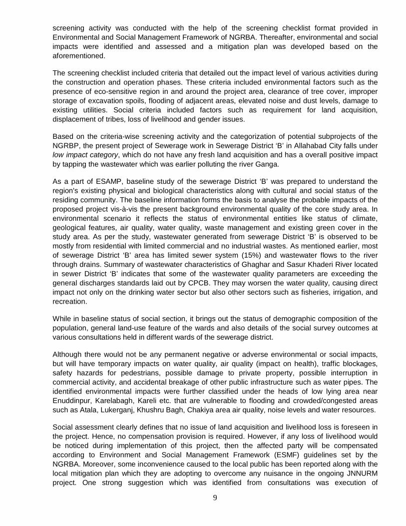
drains due to unmanaged material and construction
debris.
in any storm drains or any other areas where water would naturally accumulate causing
flooding. Operation Phase Noise and air
quality No air and noise problem
from sewer line as it will be laid underground.
Proper handling and regular maintenance of operating machines at SPS including pumps,
generators, air diffusers, etc.
Social
Construction Livelihood No impact, as there will be no impact on livelihood of
any permanent shop-owners, licensed kiosks
But suggested if noticed during
construction, then should be
compensated according to ESMF
Land acquisition No impact, as no major land
is required for any construction
Open land will be purchased from
construction of SPS
Inconvenience to public
There will be some minor inconveniences to the public
due to construction like access to their premises,
etc.
Public notice to be circulated, construction should be completed in the given time, debris should be cleared in
time
Health issues-due to dust, noise pollution
During construction dust and noise generated, can cause
nuisance to people especially elderly and
children, but impact is very limited.
Use of acoustics and water sprinkling
These temporary impacts can be mitigated with appropriate mitigation plans, which have been suggested as well, along with monitoring and evaluation of future projects. A lumpsum cost of probable environmental management plans, which is a part of DPR has been estimated to be approximately Rs. 9474622/-, which is about 0.36% of overall proposed project cost.
However, keeping in view, the temporary disruptions and impacts, it is concluded that the larger environmental value of the project greatly outweighs them. The project is expected to benefit the Allahabad City, as the wastewater that currently flows untreated into the Yamuna/Ganga river will be captured, treated and the remainder of the treated effluent will be allowed to flow into the river.

12
Chapter 1 Introduction The river Ganga has significant economic, environmental and cultural value in India. Rising in the Himalayas and flowing in to the Bay of Bengal, the river traverses a course of more than 2,500 km through the plains of north and eastern India. The Ganga main stem – which also extends into parts of Nepal, China and Bangladesh – accounts for 26 per cent of India’s landmass, 30 per cent of its water resources and more than 40 per cent of its population. The Ganga also serves as one of India’s holiest rivers whose cultural and spiritual significance transcends the boundaries of the basin.
Despite its importance, extreme pollution pressures from increasing population and industrialization pose a great threat to the biodiversity and environmental sustainability of the Ganga, with detrimental effects on both the quantity and quality of its flows. Discharge of untreated sewage and industrial wastewater, non-point pollution sources from religious activities along the river, agriculture and livestock as well as poor solid waste management are the main causes for pollution in river Ganga.
1.1 Ganga Clean up Initiatives
The Government of India (GoI) has undertaken clean-up initiatives in the past. The most prominent of such efforts was the Ganga Action Plan, launched in 1985 later complemented by a similar plan for the Yamuna, the biggest tributary of the Ganga. These programmes have faced significant public scrutiny and, despite some gains made in slowing the rate of water quality degradation, they have been widely perceived as failure. The main shortcomings of these initiatives were: (1) inadequate attention to institutional dimensions, including the absence of a long-tem-basin planning and implementation framework; (2) little effort made in addressing systemic weakness in the critical sectors of urban wastewater, solid waste management, environmental monitoring, regulation and water resources management; and (3) inadequate scale, coordination and prioritization of investments, with little emphasis on ensuring their sustainability. These programs also did not pay sufficient attention to the social dimensions of river clean-up, failing to recognize the importance of consultation, participation and awareness-raising. The lessons drawn from these prior experiences indicate that improving water quality in the Ganga cannot be achieved by plugging the infrastructure gap alone. Rather, any effective initiative will have to adopt a three-pronged approach:
Establishing a basin-level, multi-sectoral framework for addressing pollution in the river (including national/state policies and river basin management institutions);
Making relevant institutions operational and effective (e.g. with the capacity to plan, implement and manage investments and enforce regulations); and,
Implementing a phased program of prioritized infrastructure investments (with emphasis on sustainable operations and mobilization of community support)
1.2 The Ganga River Basin Project
As a major first step in achieving the above, the Government of India (GoI) constituted the National Ganga River Basin Authority (NGRBA), on 20th February 2009, for the comprehensive management of the river. The NGRBA will adopt a river-basin approach and has been given a multi-sector mandate to address both water quantity and quality aspects. The NGRBA has resolved that by year 2020, no untreated municipal sewage or industrial effluents will be discharged into River Ganga.

13
Building on the high-level dialogue with GoI on Ganga, The World Bank has been formally requested to provide long-term support to NGRBA, through several phases of substantive financing and knowledge support. While, the overall technical assistance and program development under the proposed project will focus on the entire Ganga main stem, the initial emphasis of the specific investments under the first project will focus on main stem of Ganga flowing through five basin states of Bihar, Jharkhand, Uttar Pradesh, Uttarakhand and West Bengal in India. Specifically, pollution abatement programs in cities on the banks of these States which would include a range of municipal investments such as sewer networks, waste water treatment facilities, industrial pollution control measures, river front management and solid waste disposal in the river through improved management in these cities and other required supportive improvements. This is expected to be enabled through several phases of substantive financing and knowledge support.
The first project of such several phases of support aims at;
i) Establishing and operationalizing central and state level NGRBA institutions capable of planning and implementing a multi sectoral river water quality improvement program and;
ii) Reducing pollution loads into the river through selected investments.
To achieve the above, the proposed World Bank assisted National Ganga River Basin Project (NGRBP) envisages two main components.
1.2.1 World Bank Assistance
World Bank is agreed to provide financial support the infrastructure projects for pollution abatement of river Ganga under NGRBA on the long term basis. This project is one of them under this agreement, and aims to support the NGRBA in establishing its operational-level institutions and implementing priority investments. Four projects for Allahabad town has already been approved by the NMGG for which tender is under process.
1.3 Project Components
The project will have two components relating to institutional development and priority infrastructure investments. The first component would seek to build the institutional capacity to effectively implement the overall NGRBA program, including infrastructure investments funded by the second component.
1.3.1 Component One: Institutional Development
1.3.1.1 Objective
The objectives of this component are to: (i) build functional capacity of the NGRBA’s operational institutions at both the central and state levels; and (ii) provide support to associated institutions for implementing the NGRBA program. The activities financed under this component are grouped under the following sub-components:
(a) Sub-component A: NGRBA Operationalization and Program Management
(b) Sub-component B: Technical Assistance for ULB Service Providers
(c) Sub-component C: Technical Assistance for Environmental Regulators

14
1.3.1.2 Sub Component A: NGRBA Operationalization and Program Management This sub-component is aimed at supporting the nascent operational institutions established for implementing the NGRBA program at the central and state levels on a full time basis.
The NGRBA’s operational institutions comprise the Program Management Group (PMG) at the central level, and SGRCA Program Management Groups (SPMGs) at the state level. The PMG is being established as a fully owned society of the Government of India, with suitable structure, staff, powers and leadership, to lead the planning and program management of the NGRBA program at the national level. It is supported and housed by the MOEF as the nodal Ministry. Similarly, the SPMGs are being established in the form of registered societies2, to ensure effective planning and program management at the state level.
Separating Program Management from Investment Execution: The rationale for establishing the PMG and SPMGs is to have institutions with single point responsibility for the NGRBA’s program planning, management and long-term sustainability.
Program Management for the Entire NGRBA Program: The sub-component will provide for initial setup costs of office infrastructure and equipment, as well as provision of critical consultancies, incremental staffing, training, and operation costs. Key NGRBA program management activities included under this sub-component are described below3:
(a) Enhancing Ganga Knowledge Resources
(b) Communications and Public Participation
(c) Innovative Pilots
(d) Program of Action for Carbon Credits
1.3.1.3 Sub component B: Technical Assistance for ULB Service Provider
The long term operation and maintenance of the NGRBA-funded assets is the responsibility of the ULBs and local service providers, and this sub-component is aimed at providing assistance that can gradually enable them to take on their role.
1.3.1.4 Sub-component C: Technical Assistance for Environmental Regulator
This sub-component is aimed at addressing the key constraints faced by the CPCB and SPCBs related to their functions regarding the Ganga. The subcomponent will support:
a) Capacity building of the CPCB and SPCBs
b) Up-gradation of Ganga Water Quality Monitoring System
1.3.2 Component Two: Priority Infrastructure Investments
1.3.2.1 Objective
The objective of this component is to finance demonstrative infrastructure investments to reduce pollution loads in priority locations on the river.
1.3.2.2 Four Investment Sectors

15
The majority of investments are expected to be in the wastewater sector, particularly in wastewater treatment plants and sewerage networks. Investments will also be supported in industrial pollution control and prevention (e.g. common effluent treatment plants), solid waste management (e.g. collection, transport and disposal systems), and river front management (e.g. improvement of the built environment along river stretches, improvement of small ghats and electric crematoria, and the conservation and preservation of ecologically sensitive sites). Many investments are likely to combine elements of more than one of these sectors.
1.3.2.3 The Framework Approach
In lieu of defining and appraising specific investments, the project preparation has focused on developing investments framework covering all four key sectors of intervention under the NGRBA program. This single framework will apply to all investments under the NGRBA program.
The objectives of the investments framework are to:
a) provide a filter for all the NGRBA investments, for ensuring that the selected investments are well-prepared and amongst the most effective in reducing the pollution loads;
b) make transparent the decision-making process on investments selection; and
c) ensure that the investments are implemented in a sustainable manner
1.3.2.3.1 Framework Criteria
The investments framework prescribes the criteria and quality assurance standards covering various aspects including eligibility, prioritization, planning, technical preparation, financial and economic analyses, environmental and social management, long term O&M sustainability, community participation, and local institutional capacity4.
1.3.2.4 Investment Execution
The investments program will be planned and managed by the NGRBA PMG and SPMGs, while the execution of specific infrastructure investments will be done by the selected existing and qualified state-level technical agencies. To foster competition and tap private sector efficiencies, the state governments with significant infrastructure investments are setting up a public-private joint venture infrastructure company, to execute NGRBA and other similar investments in the respective states in the medium to long term.
1.3.2.5 Rehabilitation of existing infrastructure Investments involving rehabilitation of existing infrastructure will be included on priority, due to their intrinsically higher returns in terms of reductions in pollution loads entering the Ganga.
1.4 Structure of the Report
The Detailed project Report is being prepared by UP Jal Nigam independently by carrying out environmental and social assessment. This report deals with the Environment and Social Assessment with Management Plan for the Sewerage works in Sewerage District ‘B’ of Allahabad, Uttar Pradesh. It rolls out the baseline status of the existing sewage situation and analyzes the situation if the proposed project is implemented, with its possible implications and to negate those

16
implications management plan is advised which is as per the Environment and Social Management Framework.
Report starts with the introduction of the programme to clean up River Ganga and various mechanisms to implement the project. This chapter details out the functionalities of the institutions involved in the project.
In second chapter specific project description is discussed pertaining to the proposed sewerage project in District ‘B’ of Allahabad. This chapter provides insight into the various components of the proposed project and briefly discusses the previous projects attempted for River Ganga in Allahabad.
Third chapter of the report talks about the methodology adopted for the environmental and social assessment included secondary data analysis and identifying information requirements and their sources, defining the project area and carrying out scoping in the field, survey of the host population and discussion with key stakeholders including government officials and local residents. Based on these outcomes, a screening activity was conducted with the help of the screening checklist format provided in ESMF report of NGRBA.
Chapter 4 of the report presents the applicable laws and guidelines related to such kind of projects and are in accordance with the ESMF report. It gives insight to applicable environmental and social laws including land acquisition act and forest act. While in chapter 5 detailed baseline scenario of the information available for city and for sewerage District ‘B’ is presented for both environmental and social aspects. Baseline scenario helps to assess the situation now and provides an indication of the scenario after the project execution. In environmental scenario it reflects the status of environmental entities like status of climate, geological features, air quality, water quality, waste management. As part of the social scenario, it brings out the status of demographic composition of the population, general land-use features of the wards and also details of the social survey outcomes at various consultations held in different wards of the sewerage district.
Thereafter, in chapter 6, environmental and social impacts were identified and assessed which details out the key issues related to safety, environmental concerns and livelihood. It identifies issues at various stages of the project cycle i.e. during design and development phase, construction as well as during the operation phase.
Although the project activities would not have any permanent negative or adverse environmental or social impacts, there will however be temporary, limited impacts on water quality, air quality (impact on health), traffic blockages, safety hazards, possible damage to private property, possible interruption in commercial activity, etc. The identified environmental impacts were further classified under the heads of environmentally sensitive areas, air quality, water resources and noise quality. The social impacts were further classified under impacts on human health, traffic congestion, impact on livelihood, land acquisition, impact on utilities and existing infrastructure, noise levels, safety hazards and failure to restore temporary construction sites.
These temporary impacts can be mitigated with appropriate mitigation plans, which have been focused upon in Chapter 7 of the report, along with monitoring and evaluation of future projects. However, keeping in view that the limited disruptions and impacts will only be temporary, it was concluded that the larger environmental value of the project greatly outweighs them.
It also chalks out management plan with specific environmental management plan and social management plan and also brings out cost issues related to it. For better execution of the project it

17
presents the consultation framework for participatory planning and also talks about the capacity of institutions involved.
Chapter 8 is a presentation of social development outcomes of the proposed project and related issues. It showcases the benefits of having this project and how this project can also benefit the marginalized sections of society. It suggests measures to extend the benefit of the proposed activities.
The final chapter concludes the inferences brought out from the environmental and social analysis of the project activities in Allahabad District ‘B’. It also highlights the conclusion based on the analysis which shows that the proposed project can be categorized as ‘Low Impact’.

18
Chapter 2 Project Description 2.1 About the City
Allahabad city lies on the 25°28’ North latitude and 81° 52’ East longitude. Main land of the city is surrounded by river Ganga and Yamuna in three directions i.e. North, South and east direction. The river Ganga flows on the north and east boundary of the old city while river Yamuna flows on south boundary of old city as shown in the Figure 2.1. Allahabad is among the largest cities in Uttar Pradesh. The city is situated at the auspicious confluence (Sangam) of three holy rivers 'Ganga', 'Yamuna' and the river of enlightenment, the mythical 'Saraswati'. There are very few places parallel to Allahabad not only in India but also around the world, which is described in ancient scriptures as Prayag -Prayagraj or Teerthraaj (the holiest pilgrimage centre). With the additional magnetism of Maha Kumbh Mela, hailed as the world's largest congregation of devotees, attended by millions of pilgrims, its importance can hardly be over emphasized. Over the centuries that followed, Allahabad remained on the forefront of national importance - more so, during the days of the Indian independence struggle. The chequered history of Allahabad with its religious, cultural and historical ethos also gave rise to several renowned scholars, poets, writers, thinkers, statesmen and leaders. The city being an important cantonment during the British Raj has some beautiful remnants of colonial architecture. In the early 20th century, Allahabad University was the foremost center of learning in the country. Allahabad, today has served as commercial, academic, tourism and industrial centre of eastern Uttar Pradesh and adjoining parts of the nearby States.
Plate 2.1 Anand Bhawan- house of Jawaharlal Nehru’s Family (left) and night view of New Yamuna bridge (right)5
2.2 Existing Sewerage Facilities in Allahabad City
The Sewerage system in the Allahabad city was first introduced in the year 1910. The facility was subsequently extended in a number of developing areas according to the need and financial position of the local body. The collection system covers about 45% of the city area and most of this is within the central core of the city. The total amount of wastewater measured in drains and at the STPs in the year 2013 is about 250 mld of which 211.50 mld was diverted into the sewer collection system. The wastewater flowing into the SPS (Sewage Pumping Station) is greater than the existing treatment capacity of STP, leading to overflow of untreated wastewater into the river as shown in Plate 2.2. Further the existing sewers have outlived their design life and suffer from insufficient hydraulic capabilities, heavy silt deposition, sewer choking due to ingress of solid waste and poor structural conditions in most of the stretches.

19
Presently there are 57 drains/ nalas which discharge into the rivers Ganga & Yamuna at Allahabad. Out of 57 drains, 2 drains fall in the cantonment area under the control of the defense ministry. Out of remaining 55 polluting drains, 7 major drains have been intercepted under Ganga Action Plan Phase I (GAP - I), 2 drains have been tapped under Ganga Action Plan Phase II (GAP - II), further 16 drains will be tapped under the ongoing scheme under JNNURM, 10 drains are proposed to be tapped under a scheme. DPR’s for tapping of the remaining 20 drains has recently been approved by the NMCG. UPJN (Uttar Pradesh Jal Nigam) is responsible for pollution prevention and planning capital projects for sewerage. UPJN also operates and maintains large pumping stations and the treatment plant. Jal Sansthan is responsible for maintenance of trunk sewers, lateral sewers and collection of revenue from house connections. The brief details about the completed/ on-going/ approved sewerage projects in Allahabad city are described below.
Plate 2.2 Ghaghar Nala (left) and Wastewater discharged behind the house (right)
2.2.1 Works Completed under Ganga Action Plan Phase – I (GAP-I)
With the objective of abatement of pollution to improve the river water quality and to reduce the environmental degradation, Ganga Action Plan was launched in 1985 by the Ministry of Environment & Forests, Government of India. The main focus of the Plan was on Interception & Diversion and treatment of sewage through 261 schemes spread over 25 Class I towns of U.P., Bihar and West Bengal. Nearly 34 Sewage Treatment Plants (STPs) with a treatment capacity of 869 mld have been set up under the Plan, which was completed in March 2000 at a cost of Rs. 452 crores.
The Schemes completed under GAP-I in the district of Allahabad city are summarized below: Renovation of Ghaghar nala Main Sewage Pumping Station
Renovation of Intermediate Sewage Pumping Stations
Relieving sewer in Kydganj area
Daraganj sewer and Sewage Pumping Station
Relieving sewer in Daraganj area
Tapping of Mumfordganj nala
Taping of Chachar nala & Partial taping of Ghaghar nala

20
60 mld sewage treatment works at Naini based on ASP technique.
2.2.2 Work completed under GAP II
Renovation/ Rehabilitation of Chachar nala SPS Tapping Salori nala and Construction of Sewage pumping station 29 mld Salori STP with land acquisition Construction of Morigate Sewage Pumping Station
2.2.3 BRIEF OF ONGOING SEWERAGE WORKS
i. Ongoing works Under GAP II (Approved Cost Rs. 34.51 Crore)
Dismantling of existing 36” & 27” worn-out rising mains laid over the girders of the Naini rail bridge. - Down side works completed.
Construction of steel lattice bridge over the space available on the both sides of the existing Naini rail bridge (2x930 m) - Currently 13 girder of down side of the lattice bridge has been launched and on site fabrication of 14th girder and fixing of PTFE bearings is in progress.
Laying of 2x 900 mm Ø rising mains over the newly constructed lattice bridge (2x 930m) – 930 m pipe for down side has been procured
Laying of 2x 900 mm Ø rising mains between bridge & Naini STP and between Gaughat SPS & bridge (2x 920 m) – Total 1600 m pipe has been procured.
Design & drawings of up side of the bridge has been approved by the railways and fabrications of girders are in progress. Work of up side will be taken up only after completion of the down side work to ensure proper functioning of the Naini STP.
ii. Ongoing works in Sewerage District ‘D’ Under JNNURM Approved Cost - Rs. 355.98 Crore (Original)
- Rs. 383.30 crore (Revised) Funds Released - Rs. 324.1045 Crore Expenditure (30.06.2014) - Rs 269.8522 Crore
Sl. No. Items Target Physical Progress
Remarks
1. Gravity Sewer 235 km 165.55 km 168.00 km Pipe Procured & 167.88 km length ranging from 150mm -1400 mm has been laid.
2. De-silting & rehabilitation of sewer
5. 47 km 3.425 km De-silting & CIPP lining in 4.708 km length is completed. Work is in progress.
3. Renovation of old SPS
i. Allahpur SPS 1 Job 90% Completed, Testing & trial run is in progress.
ii.Daraganj SPS 1 Job 90% Completed, Testing & trial run is in progress
iii. Alopibagh SPS 1 Job 90% Completed, Testing & trial run is in progress

21
4. Construction of new S.P.S.
I-Morigate 1 Job 90% Completed, Testing & trial run is in progress.
II-Rajapur 1 Job 75% Work is in progress, Testing & trial run is in progress with temporary arrangement due to Kumbh mela.
III-Mumfordganj 1 Job 905% Completed, Testing & trial run is in progress.
5. Rising mains 8.35 km 8.35 km Completed, Testing & trial run is in progress.
6. Construction of STP
60 mld 60% One stream of 30 mld is under testing & trial-run.
7. Construction of Ring Bund
2.25 km 50% Work is in progress. To be completed by June 2014.
iii. Sewerage & Non Sewerage works for pollution abatement of river Ganga at Allahabad Approved Cost (Total) - Rs. 305.34Crore Sewerage Component - Rs. 289.24 crore Non-Sewerage Component - Rs. 16.20 crore Funds Released - Rs. 276.57 Crore Expenditure (30.06.2014) - Rs. 222.15 Crore
Sl. No.
Items Unit Approved Quantity
Physical Progress
Commissioned
1 Trunk Sewer Km. 14.30 8.62 km 4.35 km
2 De-silting & Rehab. Of Sewer
Km. 5.72 4.43 km 4.05 km
3 Up-gradation of Existing old SPS
No/MLD 3/ 80, 35, 16 85% 2 Nos.
4 New SPS No/MLD 4/25+10+24+55 95% 3 Nos.
5 Rising Main Km 8.050 8.05 km 8.05 km
6 STP No/MLD 4/20+ 50+ 25+10 85% 4 Nos
7 Overall Physical Progress 77 % Non sewerage works including construction of 143 Nos. community toilets, renovation of 3
Nos. & construction of 2 Nos. Dhobighats and Public Awareness & Participation is being implemented by Allahabad Nagar Nigam. Community toilets – 48 completed, 9 work in progress Dhobighats - Completed

22
Public Awareness & Participation – In progress
iv. Ongoing Sewerage works in Sewerage District ‘E’ Under NGRBA
Approved Cost (Total) - Rs. 142.00 Crore Funds Released - Rs. 115.67 Crore Expenditure (30.06.2014) - Rs. 112.42 Crore
Sl. No.
Item / Description Unit Provision as per DPR
WIP Completed Comm
1 Trunk / Main/ Branch/ Lateral Sewers
Km. 110 109.00
2 New SPS No/MLD 2/15+10, 12% -
3 Rising Main Km 0.10 -
4 Overall Physical Progress 75% -
2.2.4 City Sewerage Plan For implementation of the sewerage works in the City, Allahabad is divided in seven Districts each with its own SPS and STP. Such Districts do not vary only in coverage area / size but also in the population living in the District. Also, the geographical locations of the Districts are varying which impacts on the population living in that District. The District-wise population has been worked out and documented. These seven sewerage Districts and Jhusi area on East of Allahabad city have been briefed as follows:
District A: District A covers central core conveying sewage to existing Ghaghar nala MPS and Naini STP. This area includes the old city core with an old sewerage network dating back to as early as 1910. Sewage from this area is collected at Ghaghar nala MPS and pumped through existing rising mains across the Yamuna railway bridge to Naini STP. Population densities in this area are generally greater than 300 persons per hectare and water distribution sufficiently good to support full coverage with sewerage. Sewage that does not enter the sewer system finds its way to Chachar nala, Ghaghar nala and many smaller tributary drains. Chachar nala flow is at present tapped and pumped to Ghaghar nala MPS. Renovation and up-gradation of Naini DTP by 20 mld has been done under NGRBA, MoEF, GoI. Comprehensive sewerage scheme comprising of 242 km sewer network along with 3 nos. of SPS amounting to Rs. 288.93 cr. has been approved by the NMCG vide letter dated 20.02.2014.
District B: From Lukerganj SPS to Ghaghar nala SPS, conveying sewage upstream of Yamuna River to Numaya Dahi STP. This District is west of District A from Ghaghar nala to Sasur Khaderi river. A small area lying north and west of Nurullah road is sewered and drains to Lukerganj SPS. The uninhabited area lying west towards Sasur Khaderi River is growing quickly. Sewage that does not enter the sewer system finds its way to Ghaghar nala, Sasur Khaderi River and its tributary drains. Scheme for Interception, Diversion & Treatment of 50 mld Domestic sewage is under execution under NGRBA, which is almost complete. DPR of sewerage network of 215 km sewer network along with 2 Nos. of SPS amounting to Rs. 265.86 Cr has been recommended by the Empowered Steering Committee of the MoEF GoI in its meeting held on 0502.2014 at New Delhi. Tendering of this works is under process.

23
District C: Area north of cantonment conveying sewage to Salori STP. At present the area has no sewers and waste water flow through the Salori, Allenganj and Buxibund nala which are intercepted and diverted to 29 MLD Salori STP constructed under GAP II. However, total sewage generated in this District in the is more than the capacity of the existing STP and DPRs for an additional unit of 14 MLD and 135 km sewer network has been approved by the National Mission for Clean Ganga (NMCG), Ministry of Environment and Forest (MoEF), Govt. of India. Tendering of these two works are under process.
District D: Alopibagh SPS area will convey sewage to proposed Rajapur STP. The District D is subdivided into two zones. Zone D1 is the large area south of cantonment lands that is collected at Alopibagh SPS and discharged to Ghaghar nala MPS. Zone D2 is the low-lying area north of GT road and west of Stanley road that drains to TV tower and Rajapur nalas. The existing sewerage facilities in Zone D1 are of relatively newer construction and include intermediate pumping stations at, Daraganj, Allahpur, and Morigate. This zone is experiencing rapid growth and projected populations indicate that densities will be much greater than 300 persons per hectare before 2025. Under JNNURM scheme, it is propose to redirect flows from Alopibagh SPS towards north of Allahabad for treatment at Rajapur STP via Mumfordganj MPS. A complete sewerage scheme amounting to Rs 383.30 Crore and comprising of sewerage net work, trunk sewers, sewage pumping stations, rising mains and 60 mld capacity Sewage Treatment Plant (STP) has been approved under JNNURM and construction of the same is in progress.
District E: West Allahabad conveying sewage to Kodara STP and Ponghat STP in Sulem Sarai area. This District is divided into three nala catchments, namely Ponghat nala to the west, Kodara nala (central), and Nehru Park nala to the east. Works for Interception, Diversion & Treatment of 35 mld Domestic sewage is going on under NGRBA. Construction of sewerage network along with two nos. SPS are going on under NGRBA. Sanctioned cost of the project is Rs. 142.00 Crore.
District F: Phaphamau area conveying sewage to Phaphamau STP. At present the area has no sewers but in future sewers will be laid as per requirement. Complete sewerage system along with interception, diversion and treatment facilities is proposed to be adopted under NGRBA.
District G: South of Yamuna river conveying sewage to proposed Mawaiya Nala. Proposed sewerage District G is largely un-sewered at present. Only a part of the area is covered by a network of small diameter sewers (6 to 12 inches) and a small pumping station that discharges in to the drain. The existing sewer network is inadequate in size and coverage therefore it will be completely reconfigured to accommodate future growth and to provide gravity flow to a new sewage treatment plant for which about 8 hectare near the new Yamuna bridge has been earmarked. Complete sewerage system along with interception, diversion and treatment facilities is proposed to be adopted under NGRBA.
Jhusi Area: Jhunsi District, a growth area outside the current Municipal Corporation limits to the east of Allahabad across the Ganga River. Development has occurred along both sides of the main road along the East-West axis. There are no sewers in this area. Most sewage is discharged to soak pits and septic tanks. Sewage & Sullage of this area finds its way into natural drains that discharge upstream & downstream of the Sangam. Although this area is outside the municipal corporation but construction of sewerage system along with interception, diversion and treatment facilities is essential as sewage of this area is discharged very near to the holy Sangam (Confluence of river Ganga & Yamuna).

24
Table 2.10 - Sewerage District wise sewage generation and status of STP is tabulated as under:
Sewer service area
Area (ha)
Population 2025
Sewage Production 2025 (mld)
Current Status of STP
District A 1,321 4,79,731 74.358 60+20=80 mld capacity STP is Operational
District B 874 2,79,169 43.27 50 mld capacity STP is operational
District C 647 2,67,180 41.41 29 mld capacity STP is operational 14 mld capacity STP has been recently approved by GoI
District D 1,709 3,61,352 56.01 30 mld capacity STP is operational 30 mld capacity STP is under construction
District E 928 2,23,789 34.69 25 mld at Kodra & 10 mld at Ponghat is operational and 12.5 mld at Kodra is under construction.
District F 186 65,196 10.11 DPR for 10 mld STP is to be prepared under NGRBA
District G 1,382 2,32,280 36.00 DPR for 40 mld STP is to be prepared under NGRBA
Total 7,048 19,08,697 295.85 Jhusi Area 1,08,018 16.75 DPR for 18 mld STP is to be prepared
under NGRBA
Population figures does not include daily floating population but do not include population of Kumb Mela.
2.3 Necessity of this project
Under the ‘Mission clean Ganga’ no untreated municipal sewage or industrial effluent would be allowed to be discharged in to the river Ganga by the year 2020. In Allahabad, total estimated sewerage generation of the town in the year 2025 is expected to be 295.85 mld against which only 89 mld treatment capacity is available (Naini 60+ Salori 29), 60 mld treatment capacity is under execution at Rajapur, Detailed Project Reports (DPRs) for construction of 105 mld treatment capacity (Numaya Dahi 50 mld + Kodra 25 mld + Ponghat 10 mld + Naini up-gradation by 20 mld = Total 105 mld) has been approved by the NRCD under NGRBA. Further DPR for 68 mld treatment is under preparation (Naini 40 mld +Phaphamau 10 mld + Jhunsi 18 mld) under National Ganga River Basin Authority (NGRBA).
Some part of the Sewerage District ‘B’ is the oldest & densely populated part of the city, whereas some part is newly developed area in south-west part of the city. Sewerage system exist in small and those sewers are very old, under capacity and are in deteriorated condition. Work of replacement & Laying of 4.90 km long trunk sewer is going on under NGRBA. It is evident from the above that for sewerage District ‘B’ of the city, trunk sewers are either available or created under the approved works, a 50 mld capacity STP is functional at Numayadahi.

25
For efficient utilization of the existing SPS & STPs, strengthening/ replacement of existing internal sewerage system is urgently required. Currently developments are coming up between the river & bund along the river Yamuna and waste water generated by this habitation cannot be intercepted in the sewerage system without laying & an interceptor sewer along with an intermediate sewage pumping station. For complete interception & diversion of waste water flowing through these drains, interceptor sewer & sewage pumping station is necessary. With the aim of providing complete sewerage facilities in the sewerage District ‘B’ of the city, 214.88 km long sewerage network along with 2 intermediate sewage pumping station are being proposed. Flow of this intermediate sewage pumping station will be diverted to Sasur Khaderi SPS from where it will be diverted to Numayadahi STP.
Table 2.2 Projected Populations for Allahabad Sewerage District ‘B’
Sewerage District Projected Population 2020 2035 2050
District ‘B’ 246088 316393 386700
Table 2.3 Sewage Flow Generation (Capacities in MLD)
Sewerage District Projected Sewage Flow (mld) 2020 2035 2050
District ‘B’ 38.15 49.04 59.94
District Existing
STP Capacity
Required STP in 2035
Proposed Capacity for subproject
Required in 2050
Augmentation Required for 2050
Total STP Capacity by 2050
District ‘B’ 50.00 49.04 - 59.94 10 60.00
2.4 Location of Proposed Sewerage Project
Sewerage District ‘B’ of the City of Allahabad covers south west part of the city and conveys sewage to existing Ghaghar Nala Main Pumping Station (MPS) and Numayadahi Sewage Treatment Plant (STP). This area includes the old city and also new developing areas. There are totally 12 wards falling under this project area, having a total population of 216176 as of 2011. The area is mostly residential with some main markets, institutes and hospitals.
The state of existing sewers is summarized below:
Most of the area is unsewered and existing sewers are discharging into the open drains.
Hydraulic capacities are insufficient even for the present flows
All existing lines have heavy silt deposition
Sewers are severely choked due to ingress of solid waste
All lines have large variations in constructed slopes

26
Wastewater from this area is collected at Ghaghar Nala MPS and pumped to Naini STP. The existing capacity of Ghaghar Nala MPS is sufficient to cater the flow anticipated in the year 2035.
The sewerage network has been reconfigured under the city sewerage plan to provide a smaller catchment area that will not exceed the maximum capacity of Ghaghar Nala MPS and Numayadahi STP (ultimate design capacity of 60 mld with expansion). Table 1 gives sewerage district wise projected population and wastewater production. As indicated in Table 1, population density in this area is greater than 300 persons per hectare and water distribution sufficiently good to support full coverage with sewerage. The sewer connection ratio in the district is only around 5%. Wastewater that does not enter the sewer system finds its way to Ghaghar nala and many smaller tributary drains.
Figure 2.1 Yellow Portion is Location of Sewerage District ‘B’ in Allahabad City, Uttar Pradesh.
Source: City Sewerage Plan
2.5 Proposed Sewerage System
UPJN has prepared this Detailed Project Report and also carried out environmental and social assessment. The proposed sub-project aim to provide complete sewerage facilities in the sewerage District ‘B’ of the Allahabad city. The project mainly includes:

27
Approximately 214.88 km long sewerage network along with 4.9 km trunk sewer already laid under the sewerage and non-sewerage scheme of NGRBA.
2 nos Intermediate Sewage Pumping Stations for effective interception and diversion of flow from Kalindipuram (1.8 mld) and Enuddinpur (4.1 mld).
Sewer cleaning equipment
2.5.1 Components of Proposed Sewerage Work
Comprehensive sewerage network is proposed for sewerage District ‘B’ to cover the remaining area with sewerage system, so that sewage flows can be collected in an integrated manner and conveyed to STP for treatment before discharge into Ganga river via Nallah. The proposed sewerage system is designed for 30 years period with base period of 2020 and design year 2050.
A. Sewer System
(i) Sewer Pipes: It is proposed to lay 214.88 km long sewer network in sewerage District ‘B’ of the city. Since existing trunk sewers of 4.9 km will be utilized. Therefore, only main/branch/ lateral sewers have been proposed.
Table 2.4 Size wise details of the sewers proposed for sewerage work in District ‘B’ Size/ Dia
(mm) Type of pipe Length in Zone I
(m) Length in Zone II
(m) Total Length (m)
150 HDPE 33427.3 31353.2 64780.5
200 HDPE 68569.7 55458.3 124028.0
250 HDPE 2343.9 2916.0 5259.9 300 HDPE 2224.8 2436.5 4661.3 400 RCC NP3 4436.7 2690.7 7127.4 500 RCC NP3 1843.3 2128.8 3972.1
600 RCC NP3 856.3 448.7 1305.0 700 RCC NP3 201.6 1484.5 1686.1 750 RCC NP3 447.3 363.4 810.7 800 RCC NP3 527.6 209.5 737.1
1000 RCC NP3 0.0 376.2 376.2 1100 RCC NP3 0.0 133.8 133.8
Total Length 114878.5 99999.6 214878.1
Considering the scarcity of small size RCC pipes as well as their handling problems at sites, HDPE pipes have been propose for diameter 150, 200, 250 & 300 mm. HDPE pipes are anticorrosive in sewage environment and would serve the basic purposes.
(ii) Manholes: Total 7885 Nos. of Circular/ rectangular RCC/ brick masonry manholes have been proposed in the sewer lines keeping the average distance between two manhole as less than 30 m in accordance with the provisions laid down in the IS 4111 (Part 1).

28
(iii) House connection: Sewer connection ratio of 90% is proposed to be achieved by year 14284.
B. Intermediate Sewage Pumping Stations
For effective interception and diversion of sewage flow from gate no. 9 and gate no. 13, a ghat interceptor sewer along with a sewage pumping station has been proposed along the city bank of river Yamuna. This arrangement will also take care of the habitation residing between river & Yamuna bund road and divert the flow to Gaughat SPS.
Civil works components of IPS will include
SPS comprising of screen channel, wet well and valve chamber of 10 mld
MEP room, transformer yard
Other facilities like water supply, firefighting arrangement, boundary wall, gate, approach and campus roads, information center/public relation office, 2 nos. of B type staff quarters, campus development etc.
Rising main of 250mm, 280 mm and 300 mm length
C. Sewer Cleaning Equipment
For proper maintenance of the sewerage system, provision has been made for one no. Jetting cum suction machine, one no. tractor trolley, mounted tanker and one no. submersible dredger pump.
2.5.2 Implementation Schedule
It is anticipated that entire work will be completed within 43 months from the date of approval and allotment of funds.
2.5.3 Financing
Detailed Project Report of Sewerage Works in Sewerage District ‘B’ has been prepared under National Ganga River Basin Authority (NGRBA) programme amounting to Rs. 265.86 Crores. Table 2.4 gives the summary of cost of the proposed sewerage work in sewerage District ‘B’ of Allahabad city.
Table 2.5 Overall Estimated Project Cost for proposed sewerage system project
Sl.No Description of Work Estimated Cost in Rs. Lacs
Civil Work E/ M Works
Total
1 2 6 A Sewerage work in Zone I
1 Sewer Laying by Open Excavation menthod
11941.42 0.00 11941.42
Sub Total Zone I 11941.42 0.00 11941.42

29
B Sewerage work in Zone II 1 Sewer Laying by Open Excavation
menthod 10300.37 0.00 10300.37
2 Eanuddinpur SPS 341.26 298.56 639.82 Rising main 33.59 33.59 3 Kalindipuram 300.98 274.46 575.44 Rising main 29.03 29.03
Sub Total Zone II 10976.20 573.02 11578.25 C Provision for sewer cleaning equipments 0.00 0.00 Total (A+B+C) 22917.62 573.02 23519.67 D Miscellenious Items 0.00
1 Communication & Public Outreach 95.00 0.00 20.00 2 GAAP 30.00 0.00 7.00 3 Environmental Mitigation Plan (EMP) 90.00 0.00 90.00 Sub Total D 215.00 0.00 117.00
E Contingencies @ 2% 0.00 F Labour cess @ 1% Total Work Cost 23636.67 G Centage @ 8% 1881.57 H Land Acquisition for SPS Grand Total Capital Works 25518.25 I Five Years O & M Cost 1067.56
Total Cost of DPR 26585.81

30
Chapter 3 Approach and Methodology 3.1 Methodology
As per Environmental and Social Management Frame work (NGRBA, 2011), the river pollution mitigation projects under the NGRBP is anticipated to encounter a variety of environmental and social problems. Hence, an environmental and social assessment with corresponding management plans for the proposed project of sewerage works in sewerage District ‘B’ of Allahabad City has been conducted using the following methodology.
a. Secondary Data analysis (Identify Information/Data Requirements and their Sources): All the available information and data (quantitative, qualitative) regarding the proposed project was collected mainly from the Detailed Project Report (DPR), consultation with stake-holders and other secondary sources including the water/air/noise monitoring reports of UP Pollution Board, Water Quality Management Plan of Ganga River Report of JICA and NRCD, City Development Plan of Allahabad and many others. Through this secondary information a brief description and analysis of the sub-project activities along with baseline environmental profile of the project influence was established. Based on initial understanding, the list of required information was drafted before conducting the field survey.
b. Defining the project area and carrying out scoping in the field: Team undertook the field survey and transect walk of the sewerage District ‘B’ area to develop the understanding of the proposed project. GPS surveying of the study area was also conducted for mapping the social and environmental issue. Field visits helped to understand the local knowledge and were valuable in finding alternatives that help avoid or at least reduce the magnitude and severity of adverse impacts.

31
Plate 3.1 Consultation with ambulatory vendors
c. Survey of the host population: With the help of questionnaires, local people were interviewed in groups. A wide range of potentially affected people were interviewed in District ‘B’ including street vendors, residents of households, residents of temporary settlements, shop keepers, hospital patients, hospital staff, etc. Both men and women were interviewed from different sections of the society. Team undertook three field visits to carry out the survey and understand the ground situation. The interviewees were asked about their awareness of the project, their response to it and the project is affecting them (during construction phase) and how it will affect them (after completion phase). Also they were asked about the mitigation plans they have adopted or are planning to adopt, suggestions for improvement and any public grievances. Surveys were conducted along the path of construction site. Questionnaire used for the survey is attached as Annexure (1).
Plate 3.2 Consultation with local community
d. Discussion with the key stakeholders: Most of the important key stakeholders were interacted during informal and formal discussions with them. All the associated government departments were visited to collect the relevant data and their feedback on the project activities. Minutes of meeting for all these discussions are attached as Annexure (2).
e. Conduct Screening: Screening is undertaken in the very beginning stages of project development. The purpose of screening is to screen out “no significant impacts” from those with significant impacts and get a broad picture of the nature, scale and magnitude of the

32
issues. Team conducted screening process using the screening checklist format provided in ESMF report of NGRBA, which is described in subsequent section.
f. Identify and assess the impacts: Based on the analysis of the data gathered from field survey, stakeholder interaction/ consultation and secondary sources, issues related to the environmental and social sectors were been identified. The impacts so identified were compared with the existing baseline environmental and social condition of the study region. The impacts of the activities are mostly positive with few adverse impacts.
g. Develop a mitigation plan: Based on the environmental and social issues identified, and recommend any measures needed to prevent, minimize, mitigate, or compensate for adverse impacts and improve environmental performance. The mitigation plans is suggested in all three stages: designing phase, construction phase and, operation and maintenance phase.
3.2 Screening Activity for Project Impact Assessment
Screening activity is undertaken in the very beginning stages of project development. The purpose of screening is to screen out “no significant impacts” from those with significant impacts and get a broad picture of the nature, scale and magnitude of the issues. Based on the secondary data analysis, field assessments and stakeholder interaction/ consultation, the screening activity was conducted as per the guidelines provided in Environmental and Social Management Framework of NGRBA (NGRBA, 2011) as given in the Table 3.1 below.
Table 3.1 Environment and Social information format for screening
Environment and Social information format for screening
Project Title: Sewerage Works in Sewerage District ‘B’ in Allahabad City of Uttar Pradesh Implementing agency: Ganga Pollution Control Unit, Allahabad Project cost: 265.86 lac Rupees Project components:
a). Sewer System (~214.88 km long) b). Intermediate Sewage Pumping Station d). Sewer Cleaning Equipment
Project location (Area/ district): Sewerage District ‘B’ in Allahabad
District ‘B’ covers area situated in the south west in the city, draining towards Ghaghar Nala and Sasur Khaderi river. Wastewater generated in this area is collected at Ghaghar Nala MPS and pumped through rising mains to Numayadahi STP.
Screening Criteria Assessment
of category Explanatory note for categorization
Evidence and references
Is the project in an ecosensitive area or adjoining an ecosensitive area? (Yes/No) If Yes, which is t h e area? Elaborate i m p a c t accordingly.
No There are no ecosensitive areas such as water bodies, or protected forested areas surrounding the project. The monuments in District ‘B’ will not be impacted as the sewage line will pass
Figure 5.8 Map showing the Ecosensitive areas closest to Allahabad District ‘B’.

33
through the road away from their boundary.
2 Will the project create significant/limited/no social impacts?
2.1 Land acquisition resulting in loss of income from agricultural land, plantation or other existing land-use.
No social impacts
Land acquisition is not required.
As per the first hand observation in the field and through interviews of key stakeholders, residents, local people, and other sources like DPR, CRR, it is clear that no private land would be acquired for either laying of sewer network or for SPS. Sewer line would be laid on the public roads. So there is no loss of income from agricultural land. Moreover there are no agricultural fields in the district. Also there exist no squatters or encroachers in and around the premises which will get affected due to it
Figure 5.10: indicating that the sewer line will pass through the residential colonies, commercial areas of the District ‘B’ and would not enter or pass through agricultural fields.
Field visits,
Consultation with stakeholders, like local peopl, local residents, government officials.
2.2 Loss of livelihood No Loss of livelihood would not take place and since mobile vendors can shift their position only minor disruption in terms of access to shops would occur.
Consultation with stakeholders, like DPR & CRR
2.3 Land acquisition resulting in relocation of households.
No social impacts
Land acquisition is not required. As per the first hand observation in the field and through interviews of key stakeholders, residents, local people, and other sources like DPR, CRR, it is clear that no private land would be acquired for either laying of sewer network or for building up new SPS. The project
Field survey, Consultations with stakeholders, like local people ,local residents, government officials. DPR & CRR

34
land is already available with the government and also Revenue department has confirmed the ownership. Also there exist no squatters or encroachers in and around the premises which will get affected due to it
2.4 Any reduction of access to traditional and river dependent communities (to river and areas where they earn for their primary or substantial livelihood).
No social impacts
No access problem to river
Field visits and consultations with the shop keepers, mobile vendors, expert opinions
2.5 Any displacement or adverse impact on tribal settlement(s).
No social impacts
There are no tribal settlements in the project area.
Consultations with stakeholders, like local people ,local residents, government officials.
2.6 Any specific gender issues.
No social impacts
No gender issues were reported during survey
Consultations, interviews, which were taken up with females specifically.
3 Will the project create significant / limited / no environmental impacts during the construction stage? (Significant / limited / no impacts)
3.1 Clearance of vegetation/ treecover
No environmenta l impacts
The major land use pattern of sewerage District ‘B’ is mostly residential and commercial, with no agricultural and no forested areas. Vegetation and tree cover were insignificant in the proposed project area. Also, sewer lines will be laid in the centre of the roads hence no impact on trees (which are aligned along the sides of roads) or on residential parks such as Habib Park, Guru Teg Bahadur Park, Tikona park
Field visits and Interaction with Nagar Nigam department. Figure 5.10 GIS map of ward localities in District ‘B’. Figure 3.2: Satellite image showing the alignment of trees along the sides of the roads in District ‘B’. Figure 5.7: GIS map of identified parks in District ‘B’.

35
3.3 Flooding of adjacent areas
Limited For sewerage works in the entire sewerage District ‘B’, flooding could be an issue during the monsoons, since the drainage system in sewerage District ‘B’ covers approximately 60--65 %, which is further ineffective due to blocked drains and poor solid waste management. The areas which are expected to face temporary flooding issues include slum area in Kydganj Additionally, if water pipes are inadvertently breached, flooding will result.
City Development Plan for Allahabad, Final Report by Feedback Ventures. Plate 5.1: Image showing flooded streets of Allahabad District ‘B’ after rainfall.
3.4 Improper storage and handling of substances leading to contamination of soil and water
Limited The storage of construction related material will not cause any contamination since these materials would typically include: Concrete, pipes, masonry, rubber pipes. There are no water bodies within the study area. However, with other finer materials such as powders, fluids and greases, if not appropriately managed or in the event of an accident, there may be potential for temporary contamination of the river Ganga via the various drains and nalas in sewerage District ‘B’, during rainfall.
Plate 3.4: Image showing a typical sewage construction area with material. Figure 5.6 highlights the drainage network. Section 5.1.10.1 provides details about agricultural land in sewerage District ‘B’. Additionally, there is a provision in the DPR for Allahabad Sewerage District ‘B’, Volume I, for clearance of site after construction period and unforeseen items
3.5 Elevated noise and dust emission
Limited For sewage works, construction is likely to increase dust and noise levels temporarily. Temporary impacts may especially be felt at educational facilities like schools/colleges Allahabd
Consultation with local residents, and interaction with Nagar Nigam and other Government officials

36
Degree College, Kesrvidyapith Inter College, Ewing Christian College, Shiv Charan Das, Kanhaiyalal Intermediate College Provided that construction works near schools and colleges are carried out during vacations and works near hospitals are completed on priority basis (in shorter time period with alternate provision of traffic, accessibility of exit/entry gates etc.), the impacts may be limited. If construction schedule is followed, then impacts will be temporary as 1 km of sewer line is approximated to be completed within 3 days.
3.6 Disruption to traffic movements
Limited Sewer construction leads to the temporary tearingup of roads and increase in large construction vehicles, which might impair traffic movement, especially in the narrower roads and lanes as seen mainly in Muthiganj, Rambagh.
Figure 6.1: GIS map distinguishing road network of District ‘B’ with majority of roads in the Narrow category (<=5 units). Plate 6.1: Image showing a typical busy street at Rambagh Chauraha in District ‘B’ Additionally, there is a provision in the DPR for Allahabad Sewerage District ‘B’, Volume-I for diversion of traffic/regulation during construction period
3.7 Damage to existinginfrastructure, public utilities, amenities etc.
Limited If not appropriately managed, there may be potential for temporarily affecting the existing public utilities like water supply, telephone, electricity cables etc. Records and layout plans
Interaction with Nagar Nigam and other Government officials. Additionally, there is a provision in the DPR for Allahabad Sewerage District ‘B’, Volumefor shifting &

37
of existing underground utilities and cable networks (like telephone, electricity water etc.) were unavailable.
reinstatement of utilities
3.8 Failure to restore temporary construction sites
Limited From field visits and as per JNNURM project reinstatement of dismantled roads after filling and proper compaction was observed. Although temporary, concerns regarding failure to restore construction sites including failure to close and appropriately fenceoff open pits were cited as safety concerns especially for children.
Field visits and interaction with Nagar Nigam and other Government officials and consultation with local residents. Plate 3.5: Image shows the good practice of fencing-off construction areas; this was followed in the JNNURM phase sewerage project in Allahabad. Additionally, there is a provision in the DPR for Allahabad Sewerage District ‘B’, Volume I, for clearance of site after construction period and unforeseen items
3.9 Possible conflicts with and/or disruption to local community
Limited For the laying of sewer works, there will be temporary disruption to the local community in terms of access to roads (narrow roads), shops and residences. Conflicts/disruption to local community was inferred as limited based on survey responses which indicated the community’s ability to adapt to temporary disruptions, and their overall preference for the project.
Consultation with local people
3.10 Health risks due to unhygienic conditions at workers camps
Limited Field visits and as per JNNURM project no worker camps were seen. However there might be small camps within which, if hygienic

38
conditions are not maintained, there may be temporary impacts.
3.11 Safety hazards during construction
Limited From field visits and as per JNNURM project practices for safety precautions such as fencing-off construction areas, sign posts etc. were observed. If not appropriately managed, there may be potential for temporary hazards such as injuries and damage to property during the construction phase.
Consultation with local residents of sewerage District ‘B’ and interaction with Nagar Nigam and other Government officials. Plate 3.5: Image shows the good practice of fencing-off construction areas; this was followed in the JNNURM phase sewerage project in Allahabad.
4 Will the project create significant / limited / no environmental impacts during the operational stage? (Significant / limited / no impacts)
4.1 Flooding of adjacent areas
Limited Due to the construction of sewer lines, raw sewage that currently flows into the river and/or overflows into the streets will now be routed to the STP. This will prevent flooding of adjacent areas. However, accidental leakages during the operational stage will lead to flooding. Additionally, overloading and blockage of sewage lines will also lead to backlogging of sewers and flooding of branch sewers.
Interaction with Nagar Nigam and other Government officials. Refer to Plate 5.1 for area which has been flooded
4.2 Impacts to water quality due to effluent discharge
No impacts There will be a significant improvement in water quality due to effluent discharge being treated.
Table 5.12: Sewage flow quality values before and after existing STP. section 5.1.8
4.3 Gas emissions No impacts There will be reduction in gas emissions from open sewage drains since the proposed sewage networks will be underground.

39
4.4 Safety hazards No impacts There will be minimum safety hazards since the pipes will be underground.
5 Do projects of this nature /type require prior environmental clearance either from the MOEF or from a relevant state Government department? (MOEF/ relevant State Government department/ No clearance at all)
No clearance at all
Project such as these have an overall positive impact for the environment and society. Hence no clearance would be required under the Environmental Impact Assessment Notification, 2006.
Refer to Figure 5.8 Refer to Figure 5.7
6 Does the project involve any prior clearance from the MOEF or State Forest department for either the conversion of forest land or for tree- cutting? (Yes/ No).If yes, which?
No As the project is in urban provinces and does not cover any forested area (protected nor reserved forest area), hence no prior clearance is required from relevant authorities (MoEF and State Forest departments) under the Forest (Conservation) Act, 1980.
Refer to Figure 3.2 Refer to Figure 5.8
The following figure/ pictures given below provide substantial insights into potential problems during construction which have been addressed in screening checklist.

40
Figure 3.2 Satellite image showing the alignment of trees along the sides of the roads in District ‘B’ (Source: Google Earth)
Plate 3.3 Slum region near Karela Bagh, where residents have had complaints related to flooding due to the low lying location.
Plate 3.4 Typical sewage construction area with material (background) and re-instated road (foreground)

41
3.3 Conclusion of Screening Activity
In order to facilitate effective management and mitigation of the any impacts arising from the proposed projects, the Environmental and Social Management Framework of NRGBA (Section # 4 of ESMF report, NGRBA 2011)11 has grouped the pollution abatement projects/ investments into the following two categories high and low
High: Mainly include the sub-projects which are likely to have adverse impact on the environmental and social aspects of the project influence area (including land acquisition). This category projects will also include mandatory environmental clearance as per the EIA notification.
Low: Projects which are likely to cause minimal or no adverse environmental impacts on human populations.
Based on the screening activity and the categorization of potential sub-projects of the NGRBP, the present project of Sewerage work in Sewerage District ‘B’ in Allahabad City falls under low impact category, which do not have any land acquisition. In view of the above, these projects would require preparation of an Environmental and Social Assessment, as part of the DPR, and implementation of Generic Safeguard Management Plan (SMP), relevant to the project.
Although there would not be any permanent negative or adverse environmental impacts, but will have temporary impacts like traffic blockages, dust, noise, safety hazards for pedestrians, possible damage to private property, possible interruption in commercial activity, and accidental breakage of other public infrastructure such as water pipes. These temporary impacts can be mitigated with appropriate mitigation plans. However, the large environmental benefit of the project greatly outweighs the temporary inconveniences.

42
Chapter 4 Regulations and Legal Framework 4.1 Applicable Laws and Regulations – Environmental
The following laws and regulations are applicable to the environmental and social aspects of the investments implemented under the programme:
Policy and Regulatory Framework of Government of India (GoI)
Environmental Policy and Regulations of the respective State Governments
Legislations applicable to construction activities
4.1.1 Legal Framework of Government of India
The Government of India has laid out various policy guidelines, acts and regulations pertaining to environment. The Environment (Protection) Act, 1986 is umbrella legislation for the protection of environment. As per this Act, the responsibility to administer the legislation has been jointly entrusted to the Ministry of Environment and Forests (MoEF) and the Central Pollution Control Board (CPCB)/ State Pollution Control Boards (SPCBs).
4.1.2 Key Environmental Laws and Regulations
The key environmental laws and regulations as relevant to the projects under the NGRBP are given in Table 4.1. The key environmental regulations can also be accessed at www.moef.nic.in/rules-and-regulations
Table 4.1 Environmental Regulations and Legislations S.No Act / Rules Purpose Applicable
Yes/ No Reason for
Applicability Authority
1 Environment Protection Act-1986
To protect and improve overall
environment
Yes As all environmental notifications, rules and schedules are
issued under this act.
MoEF, Gol, DoE, State
Gov. CPCB, SPCB
Environmental Impact Assessment Notification 14th Sep-2006
To provide environmental
clearance to new development
activities following
environmental impact
assessment
Yes This notification is applicable only for Sewage Treatment Facility and Solid waste Treatment
facility investments
MoEF, EIAA
Municipal Wastes(Management and Handling) Rules, 2000
To manage the collection,
transportation, segregation,
treatment, and disposal of
municipal solid wastes
Yes This notification is applicable only for
Municipal Solid waste Treatment
facility investments
MoEF, EIAA, CPCB, SPCBs
4 The Land Acquisition Set out rule for Yes This act will be Revenue

43
Act 1894 (As amended in 1985)
acquisition. of land by
government
applicable to as there will be acquisition of land for investments
Department State
Government 5 Air (Prevention and
Control of Pollution) Act, 1981
To control air pollution by controlling
emission of air pollutants as per the prescribed
standards.
Yes This act will be applicable during
construction.
SPCBs
6 Water ( Prevention and Control of Pollution) Act1974
To control water pollution by controlling
discharge of pollutants as per the prescribed
standards
Yes This act will be applicable during
construction.
SPCBs
7 The Noise Pollution (Regulation and Control) Rules, 2000
The standards for noise for day and night have been promulgated by
the MoEF for various land
uses.
Yes This act will be applicable for all
construction equipment deployed
at worksite.
SPCBs
8 Ancient Monuments and Archaeological Sites and Remains Act1958
Conservation of cultural and
historical remains found in India
Yes This act will be applicable, only if
any investment is in proximity to any
Ancient Monument, declared protected
under the act.
Archaeological Department Gol, Indian Heritage
Society and Indian National
Trust for Art and Culture
Heritage (INTACH).
9 Public Liability and Insurance Act 1991
Protection form hazardous
materials and accidents.
Yes Contractor need to stock hazardous
material like diesel, Bitumen, Emulsions
etc.
SPCBs
10 Central Motor Vehicle Act 1988
To check vehicular air and noise pollution.
Yes This rule will be applicable to vehicles
deployed for construction activities
and construction Machinery.
Motor Vehicle Department
11 National Forest Policy, 1988
To maintain ecological
stability through preservation and
restoration of biological diversity.
No This policy will be applicable if any eco
sensitive feature exists in and around
the investments
Forest Department,
State Government
and Ministry of Environment and Forests,
Government of India

44
4.2 Applicable Laws and Regulations - Social
All strategic interventions on human development, spread across all social issues, need directives of policies and legal support to operationalize the appropriate actions. These policies and legislations help to overcome the constraints and support administrator, implementer, community and individual in delivery of justice. This section includes the National policies and Acts as detailed under:
National Policies and Acts
i) National Tribal Policy, 2006 ii) National Resettlement and Rehabilitation Policy, 2007 iii) Land (Acquisition) Act 1894 (as amended)
4.2.1 National Policies and Acts
The National Tribal Policy (2006)
The Policy has the following objectives:
Regulatory Protection
Providing an environment conducive to the preservation of traditional and customary systems and regime of rights and concessions enjoyed by different ST communities, and reconciliation of modes of socio-economic development with these.
Preventing alienation of land owned by STs and restoring possession of wrongfully alienated lands.
Protection and vesting of rights of STs on forestlands and other forest rights including ownership over minor forest produce (MFP), minerals and water bodies through appropriate legislations and conversion of all forest villages into revenue villages.
Providing a legislative frame for rehabilitation and resettlement in order to minimize displacement, ensure that affected persons are partners in the growth in the zone of influence, provide for compensation of social and opportunity cost in addition to market value of the land and rights over common property (NPV).
Empowerment of tribal communities to promote self-governance and self-rule as per the provisions and spirit of the Panchayats (Extension to the Scheduled Areas) Act, 1996.
Protection of political rights to ensure greater and active participation of tribal peoples in political bodies at all levels.
4.2.2 National Resettlement and Rehabilitation Policy for Project Affected
Families – 2007
The national policy on resettlement and rehabilitation represents a significant milestone in the development of a systematic approach to addressing resettlement. The policy establishes a Guideline for extending additional assistance to project-affected families, over and above the compensation for affected assets provided under the Land Acquisition (LA) Act. This policy strikes a balance between the need for land for developmental activities and protecting the interests of land

45
owners and others. The benefits under the new policy are available to all Affected Persons (AP) and families whose land, property or livelihood is adversely affected by land acquisition, involuntary displacement due to natural calamities, etc.
4.2.3 Land Acquisition Act, 1894 (As Modified Until 1st September, 1985)
The Act is applicable to the whole of India except the state of Jammu and Kashmir. The policy provides a broad guideline of procedure of land acquisition. The Land Acquisition (LA) Act of 1984 is commonly used for acquisition of land for any public purpose. It is used at the State level with State amendments made to suit local requirements.
Expropriation of and compensation for land, houses and other immovable assets are carried out under the Land Acquisition (Amendment) Act, 1984. The Act deals with compulsory acquisition of private land for public purpose. The LA Act does not contain any provision specifically dealing with resettlement including income restoration aspects.
Table 4.2 The Land Acquisition Process
Legal Provision Legal Provision Actions
Section 4 Draft prepared by requiring body, verified by the Ministry of Law, printing and proof reading. Publish in official gazette and two local newspapers; post notice locality No further land sales, transfers or subdivisions after notice Appoint Land Acquisition Officer (LAO) to survey land Notices under section 4(1) issued to individual owners and interested parties (one month)
Declaration of Public purpose
Government certifies that land is required for a public purpose Declaration is published Collector / Deputy Commissioner receives order from Revenue Department, State Government Land appraisal begins (two weeks to a month)
Section 5(a) Enquiry Enquire objections to LA Land owners and interested parties appear before LAO Revenue commissioner calls for comments of acquiring agency if objections are raised – (one to three months)
Section 6 State government issues notices LAO serves individual notice on all interested parties of government’s intention to take possession of land Time and place set for claims to LAO Public notice given Collector or LAO investigate claims (12 months)
Section 9 LAO conducts on-site inquiry regarding area of LA and compensation payable LAO determines compensation (12 months)
Section 11 and 12 Declaration of final award by Collector/Commissioner/State Government after inquiry of total valuation Notice of awards given to interested parties for payment of compensation Government can take possession of land and hand over to implementing agency (14 months)

46
4.3 Other Legislations applicable to Construction Projects under NGRBP
Construction stage generally involves equity, safety and public health issues. The construction agencies therefore will be required to comply with laws of the land, which include inter alia, the following:
1. Workmen's Compensation Act 1923 (the Act provides for compensation in case of injury by accident arising out of and during the course of employment);
2. Payment of Gratuity Act, 1972 (gratuity is payable to an employee under the Act on satisfaction of certain conditions on separation if an employee has completed 5 years);
3. Employees PF and Miscellaneous Provision Act 1952 (the Act provides for monthly contributions by the employer plus workers);
4. Maternity Benefit Act, 1951 (the Act provides for leave and some other benefits to women employees in case of confinement or miscarriage, etc.);
5. Contract Labor (Regulation and Abolition) Act, 1970 (the Act provides for certain welfare measures to be provided by the contractor to contract labour);
6. Minimum Wages Act, 1948 (the employer is supposed to pay not less than the Minimum Wages fixed by the Government as per provisions of the Act);
7. Payment of Wages Act, 1936 (it lays down as to by what date the wages are to be paid, when it will be paid and what deductions can be made from the wages of the workers);
8. Equal Remuneration Act, 1979 (the Act provides for payment of equal wages for work of equal nature to Male and Female workers and not for making discrimination against Female employees);
9. Payment of Bonus Act, 1965 (the Act provides for payments of annual bonus subject to a minimum of 83.3% of wages and maximum of 20% of wages);
10. Industrial Disputes Act, 1947 (the Act lays down the machinery and procedure for resolution of industrial disputes, in what situations a strike or lock-out becomes illegal and what are the requirements for laying off or retrenching the employees or closing down the establishment);
11. Industrial Employment (Standing Orders) Act; 1946 (the Act provides for laying down rules governing the conditions of employment);
12. Trade Unions Act, 1926 (the Act lays down the procedure for registration of trade unions of workers and employers. The trade unions registered under the Act have been given certain immunities from civil and criminal liabilities);
13. Child Labour (Prohibition and Regulation) Act, 1986 (the Act prohibits employment of children below 14 years of age in certain occupations and processes and provides for regulation of employment of children in all other occupations and processes. Employment of child labour is prohibited in Building and Construction Industry);
14. Inter-State Migrant Workmen‟s (Regulation of Employment and Conditions of Service) Act, 1979 (the inter-state migrant workers, in an establishment to which this Act becomes

47
applicable, are required to be provided certain facilities such as housing, medical aid, travelling expenses from home to the establishment and back, etc.);
15. The Building and Other Construction Workers (Regulation of Employment and Conditions of Service) Act, 1996 and the Cess Act of 1996 (all the establishments who carry on any building or other construction work and employs 10 or more workers are covered under this Act; the employer of the establishment is required to provide safety measures at the building or construction work and other welfare measures, such as canteens, first-aid facilities, ambulance, housing accommodation for Workers near the workplace, etc.);

48
Chapter 5 Baseline Status The baseline environmental and social status is important to understand the region's existing physical and biological characteristics along with cultural and social status of the residing community. Information and data presented in this section is based on field surveys, stake-holder interaction/consultation and secondary data collection which majorly include the draft Detailed Project Report (DPR) of proposed sewerage work in Allahabad city, City Development Plan (CDP) report by Nagar Nigam, Water/ Air/ Noise quality monitoring report of UP Pollution Control Board, City census data and others. The information on the baseline environmental conditions forms the basis to analyse the probable impacts of the proposed project vis-à-vis the present background environmental quality of the core study area.
5.1 Baseline Environmental
5.1.1 Physiography and Topography
Allahabad city as a whole occupies the inter-fluvial belt of Ganga River in the north and the Yamuna in the south. The confluence (Sangam) of the two rivers lies in the south east of the city. These rivers are perennial rivers, which carry huge volumes of water during the rainy season. Sewerage District ‘B’ is located in the southern part of the city, adjoining the river Yamuna in the south side.
Allahabad district is mainly characterized with Ganga, Yamuna alluvial plain and Vindhyan Plateau. Geological Survey of India (2001) has identified the following geomorphic features,
Active Flood Plain: It is quite localized and confined only to the river system.
Older Alluvial Plain: It is characterized by depositional and erosional terraces found in patches along the active plain.
Rocky Surface (Denudational hills): These are prominent in trans-Yamuna area formed mainly of quartzitic nature.
Allahabad district may be divided into three distinct Physical parts, the trans-Ganga or the Gangapar Plain, the Doab and the trans-Yamuna or the Yamunapar tract which is formed by the Ganga and its tributary, the Yamuna, the latter joining the former at Allahabad, the confluence being known as Sangam. The master slope of trans-Ganga is towards east or south east, with the altitude ranging from 89.30 - 93.57m above MSL.
5.1.2 Climate
Climate of Allahabad district is continental. The climate of Allahabad is tropical with moderate winter and severe extended summer. The nearest large body of water i.e. the Bay of Bengal is more than 700 km eastward. Due to this, there is a large range of variation in temperatures of day and night. Allahabad experiences both very dry hot summers and very cold winters every year. Dust storms in summer and cold north winds in winter are common. The average normal maximum temperature has been observed as 41.8ºC during May and minimum of 8.9ºC during January. The highest relative humidity in the morning is 85% during August and the lowest being 32% in April. The district receives rainfall from the south-west monsoon from June to September. The average rainfall being 962.68 mm takes place normally in 53 days. The climate information of Temperature, Humidity and Rainfall at Allahabad is given in Table 5.1 below.

49
Table 5.1 Climatological Normal of Temperature, Humidity and Rainfall at Allahabad Month Temperature (oC) Mean rainfall
in mm Humidity (%)
Maximum Minimum 0830 Hrs 1730 Hrs
January 23.5 8.9 17.9 78 53 February 26.7 11.4 17.3 66 40
March 33.3 16.6 9.6 46 25 April 39 22.3 5.5 32 18 May 41.8 26.7 8.7 36 36 June 39.8 28.4 88.8 55 41 July 34 26.5 280.8 80 71
August 32.5 25.9 296.1 85 77 September 33 24.9 184.9 80 71
October 32.9 20.2 36.6 69 55 November 29.2 13.5 9.3 65 49 December 24.6 9.3 6.9 75 56
Source: India Metrological Department data from 1901-2000 (except Humidity data which is 1951-1980)
5.1.3 Geological and Geophysical features
The sewerage District ‘B’ and whole city of Allahabad occupies the inter-fluvial sediment of the Ganga River and Yamuna River. These sediments are essentially a sequence of clays, sands, silts with inter-spread bands of Kankar having limited extent. Broadly these fluvial sediments are grouped as younger and older alluvium. The younger alluvium is generally confined to a depth of 60 m below the ground and it occupies the present day flood plain area. The older alluvial sediments marginally differ in lithology from that of younger alluvium sediments, with presence of sandy clay and lenses of gravel/pebbles and Kankar. The older alluvium overlies the Siwalik group of formations, which in turn overlies the pre-Cambrian formation. The generalized stratigraphic sequence of the formations is given in Table 5.2. The age of these formations range from Proterozoic to recent. Granite of Bundelkhand massit group forms the basement in the area which is unconformably overlain by Quaternary alluvium.
Table 5.2 Generalized Stratigraphic Sequence Time
Time Unit Formation Rock Unit Thickness (m) Recent to 0.01 m year Newer Alluvium Sand & Clay
60-100 Holocene < 1m year Older Alluvium Sand, clay,
pebble, gravel and Kankar
100-200
------------------------------- Unconformity------------------------------- Pleistocene & Pleocene Siwalik Conglomerate,
sandstone shale etc.
Above 350 m
------------------------------- Unconformity------------------------------- Pre Cambrian Vindhyan Sand stone, Not known

50
Limestone
------------------------------- Unconformity------------------------------- Archean Bundelkhand
massit Granite Basement
Source: CGWB, 2009 and Final Report on Water Quality Management Plan for Ganga River, July 2005. Volume IV-3, Feasibility Study for Allahabad City, Part I, Sewerage Scheme 5.1.3.1 Soil
Soils in sewerage District ‘B’ usually comprises a layer of clay on the top surface, with a thickness ranging between 10-15 m. Thick sandy horizon occurs beneath the top clay layer having sufficiently large thickness. The soil in this area, i.e., Doab has three distinct types. Sandy soil is found on the the banks/ flood plain of the rivers (Yamuna bank of District ‘B’) , clay is found in the depressions and loam, a mixture of sand and clay that is usually a rich and rather dark soil, the less fertile variety. Chemical analysis study of the soil for Allahabad city carried out by JICA has been presented in the Table 5.3 below:
Table 5.3 Quality of soil sample
S. No. Parameters Range of test results 1 Type Silty Clay 2 pH
7.9-8.0 3 Bulk density (g/cm)
1.2-1.28 4 Conductivity (μmhos/cm)
390.5-371.6 5 Water holding capacity
(%by mass) 47.7-49.54 6 Organic matter (% by
mass) 1.08-1.16
Source: Final Report on Water Quality Management Plan for Ganga River, July 2005. Volume IV-3, Feasibility Study for Allahabad City, Part I, Sewerage Scheme
5.1.4 Ambient Air Quality
Air quality is a measure of the condition of air relative to the requirements of one or more biotic species and/or to any human need or purpose. Presently, air quality monitoring is conducted by the NAMP (National Air Monitoring Programme-CPCB) and UP Pollution Control Board at two locations: Bharat Yantra Nigam Limited office and Square crossing near Laxmi talkies in Allahabad City. Although, Allahabad city does not fall under the identified list of polluted cities in India, but the available data from NAMP monitoring shows that the dust levels, PM10 (RSPM and SPM) have violated the annual average standards of 60μg/m3 from 2007 to 2010. The sulphur-di oxide (SO2) concentration have gone down with reduced sulphur content in the fuels from 2007 to 2009 as shown in Figure 5.1 and is well within the permissible standards of 50 μg/m3. The nitrogen-dioxide (NO2) concentrations, though not violating the standards of 40μg/m3, may exceed in future due to urbanization and rise in vehicular activities.
Table 5.4 Latest air quality data of two monitoring stations in Allahabad (March 2010 to April 2011)
Location Landuse Sulphurdi- Nitrogendi- Respirable Suspended

51
oxide oxide Suspended particulate
matter (RSPM)
particulate matter (SPM)
Square crossing circle of Laxmi talkies
Mixed 5.7 23.6 237.7 469.4
Bharat Yantra Nigam Ltd.
Residential 5.4 23.7 232.6 459.4
Source: UP Pollution Control Board, 2011
Seasonal Variation
Month-wise variations of NO2 and RSPM concentrations at the two monitoring stations are presented in Figure 5.2. Both the stations violate the permissible standards of RSPM during all the months. Lowest pollutant concentrations are observed in monsoon months and maximum were observed during winters due to inversion conditions. The effects of inhaling particulate matter that have been widely studied in humans and animals now include asthma, lung cancer, cardiovascular issues, birth defects, and premature death.

52
.
Figure 5.2 Monthwise variation of NO2 and RSPM at two monitoring stations in Allahabad (Source: UP Pollution Control Board, 2011)
5.1.5 Noise Environment

53
Noise, in general, is sound that is composed of many frequency components of varying loudness distributed over the audible frequency range. Increasing ambient noise levels in public places from various sources, inter-alia, industrial activity, construction activity, fire crackers, sound producing instruments, generator sets, loud speakers, public address ystems, music systems, vehicular horns and other mechanical devices may have deleterious effects on human health and the psychological well-being of the people; hence it is considered necessary to regulate and control any such noise pollution. Limited noise level monitoring was carried out by JICA at three locations: Numaya Dahi, Sulem Sarai and near M office, is as shown in
Table 5.5 below. Although, the monitoring stations do not come under sewerage District ‘B’ except for Sulem Sarai but provide a probable idea of expected noise levels. The noise levels at Numaya Dahi village are well within the permissible limits laid down by CPCB (for both day and night time), whereas the noise levels at Sulem Sarai and near DM office are higher than the desirable level for residential area but below the permissible level of commercial and industrial area, respectively.
Table 5.5 Summary of Noise Level Monitored Data Code Range of noise levels [Leq in dB (A)] S.No. Location
Levels in dB(A) Leq*
Day Night Average
1 Numaya Dahi 45.8 41.1 44.0 2 Sulem Sarai 56.3 48.4 53.4 3 Near Office DM 72.4 54.5 65.7
Note:
Permissible limit laid down by CPCB: Residential area (55 day time and 45 night time), Commercial area (65 day time and 55 night time)and Industrial area (75 day time and 70 night time)
* dB(A) Leq denotes the time weighted average of the level of sound in decibels on scale A which is relatable to human hearing.
Leq: It is an energy mean of the noise level over a specified time period
Source: The Noise Pollution (Regulation and Control) Rules 2000, CPCB, and Final Report on Water
Quality Management Plan for Ganga River, July 2005. Volume IV-3, Feasibility Study for Allahabad City, Part I, Sewerage Scheme
Seasonal Variation
The more recent results of monitoring carried out by the UP Pollution Control Board, during 2010-2011 on various days and at various locations in Allahabad city are presented in Figure
5.3. Results are averaged for various locations in different area categories (residential, commercial, industrial and sensitive). It can be seen that overall, day noise levels are higher than the night ones and are above the standard at most of the locations. From Figure 5.3, it can be seen that for residential area like in most parts of District ‘B’ the noise levels are almost within the permissible limits for most of the days.

54
Source: UP Pollution Control Board, 2011
5.1.6 Water Environment
Both ground water and surface water sources are utilized to provide for the drinking water requirement of sewerage District ‘B’ and Allahabad city in general. Allahabad Jal Sansthan is the responsible agency for drawing surface water from river Yamuna and installing tube wells for supply to residential/ commercial and industrial sector. The raw water from River Yamuna is being tapped for water supply at Karelibagh raw water pumping station which is pumped to Khusro Bagh water works for treatment before it is supplied to the consumers. As of 2003, about 217mld of water was supplied by Jal Sansthan department to entire Allahabad city. In addition to this, there is sizable amount of unaccounted water supply from private/ institutional bore wells. Considering the per capita water consumption of 190 litres (including UFW allowance and institutional demand), as provided in the detailed project report (DPR) for sewer works in sewerage District ‘B’ by Ganga Pollution Control Unit (GPCU), the total water consumption in sewerage District ‘B’ is approximately 76.98 million litres as shown in Table 5.6 below. This consumption is expected to increase with growing population and urbanization.
Table 5.6 Water consumption in sewerage District ‘B’ Location Population (as of
2011) Per capita water
consumption per day as per DPR
Total water consumption in
million litres Sewerage District ‘B’ of Allahabad city
216176 190 76.98
5.1.6.1 Surface Water
An important surface water system of the city is the easterly flowing Yamuna river which lies south of the main city. The Ganga is second important source of surface water which flows easterly and then

55
abruptly turns south wards close to eastern end of city and finally meets Yamuna River close to celebrated temple of Lord Hanuman in Sangam area of the city. River Yamuna lies to the southern side of the District ‘B’ and River Ganga is towards eastern side of sewerage District ‘B’, The maximum discharge of river Ganga at Sangam is about 16187- 12265 m3/s mainly during the months of August and September and the minimum discharge is 366 to 339 m3/s during April and May as shown in table 5.7. A lack of water in river increases their susceptibility to water pollution, due to discharge of untreated waste water especially during the dry season.
Table 5.7 Discharge of the Ganga at Allahabad (Sangam) (m3/s) Year Jan Feb Mar Apr May Jun Jul Aug Sep Oct Nov Dec 1972 401.38 433.61 294.13 288.22 362.67 230.12 2609.37 6664.86 13253.85 2065.6 644.51 489.48 1973 389.03 347.81 283.07 225.23 221.7 478.79 13784 21527.1 28809.04 4651.25 1073.44 598.22 1974 507.35 384.54 325.14 267.79 307.61 260.77 9149.19 19693.1 3915.68 1100.98 691.88 488.52 1975 462.97 303.01 265.96 270.39 189.88 572.22 9742.86 18209.5 15767.68 4366.54 1303.98 724.01 1976 669.83 557.91 420.13 420.78 383.05 1117.08 3359.8 18221.7 161.42.34 1893.42 553.63 482.89 1977 335.1 327.9 270.71 394.99 373.86 332.77 9115.64 17417.4 14236.34 3051.76 1121.82 750.47 1978 707.07 623.33 740.88 707.16 556.8 1077.63 7994.05 29786.2 22399.45 3980.05 1346.27 964.36 1979 924.76 1123.35 217.99 678.51 582.7 474.02 4357.59 5701.17 1476.75 598.01 318.43 518.45 1980 380.91 288.71 224.58 151.84 123.71 406.3 6804.97 21670.9 11438.9 1441.81 684.11 443.14 1981 430.99 439.37 337.12 329.04 314.16 303.28 5841.3 11215 3259.22 2337.97 674.15 507.81 1982 476.17 741.79 645.68 689.06 624.22 626.4 1779.81 28824.3 16981.02 1398.27 763.93 616.34 1983 565.77 552.64 357.87 312.95 499.11 503.91 3738.99 12823 22159.27 7019.81 1522.83 767.78 1984 721.53 551.58 486.94 367.11 279.16 575.6 2261.22 10243.4 11080.78 1237.75 571.11 400.81 1985 433.23 323.99 238.99 262.01 237.49 257.07 1827.61 15588.6 10073.87 12078.5 2174.33 745.18 1986 588.76 736.23 554.26 372.11 309.6 382.35 11078.1 17832 4199.39 1539.24 740.38 519.89 1987 497.74 399.46 334.12 271.71 238.36 247.44 1116.56 3277.58 12471.41 1968.6 589.38 366.13 1988 327.21 279.35 261.2 216.16 173.64 165.69 5489.87 16483.9 4730.56 4060.86 9520.2 476.83
Source: Final Report on Water Quality Management Plan for Ganga River, July 2005. Volume IV-3, Feasibility Study for Allahabad City, Part I, Sewerage Scheme
Surface Water Quality
Water quality status of river Ganga at two places in Allahabad is shown in Figure 5.4 and Figure 5.5. As per the monitoring results, a slight increase in Biological Oxygen Demand (BOD) concentrations has been observed during last few years. The values have crossed the 3 mg/l mark and depicts that the quality is not within permissible limits. But, the Dissolved Oxygen (DO) levels in the river have been sufficiently high and consistent over the past few years (Figure 5.5). There is a general increase in BOD concentrations as the Ganga passes sewerage District ‘B’, the most prominent of which is the increase of 1mg/l that was observed in 2002. In recent years, there had been an increasing trend of BOD concentrations in incoming water (Rasoolabad ghat) and more evident trend observed in the outgoing water (Sangam). From the year 2004 to 2008 an increase in BOD of around 0.4 mg/l to 0.6 mg/l in outgoing water of river Ganga has been witnessed. This increase can be attributed to the untreated sewage that has been directly discharged to the river Ganga including some proportion from District ‘B’ also.

56
Sangam, the confluence of the Ganga and Yamuna, is the venue of many sacred fairs and rituals, and attracts thousands of pilgrims throughout the year. This number swells to millions during the

57
world-famous Kumbh Mela creating high stress on public utilities. Table 5.8 shows the water quality of river Ganga and Yamuna at Allahabad (UP) during Maghmela (Ardh Kumbha) 2007. It is quite evident that during events like Khumb Mela, the pollution levels are very high with Biological Oxygen Demand (BOD) concentration more than 6mg/l, crossing the permissible limit (standards as per IS Code – 2296-1982) of 2mg/l for drinking and 3 mg/l for bathing as per CPCB. The biological oxygen demand, chemical oxygen demand, and fecal coliform levels were all elevated during bathing12.
Table 5.8 Water Quality of River Ganga and Yamuna at Allahabad (UP) during Maghmela (Ardh Kumbha) 2007
Location BOD (mg/l) DO (mg/l) Yamuna at Naini Bridge (U/s Sangam)
1.7 8.6
Ganga at Shstri Bridge (U/s sangam)
5.7 10.4
Sangam 4.3 9.3 Yamuna at Karella Bagh 1.8 6.8 Ganga at Phaphamau u/s Sangam
6.4 8.3
Ganga at Diha Ghat d/s Allahabad
4.3 6.3
Recent Data
As per the latest water quality monitoring conducted by UP Pollution Control Board (Table 5.9), the biochemical oxygen demand (BOD) levels at all stations are often above the permissible 3.0 mg/l for outdoor bathing waters and also above 2.0 mg/l limit for the drinking water standard, as set by the Indian Standard code. However, the water quality parameter of dissolved oxygen (DO) seems within permissible limits. The minimum DO levels for water as per the Indian standard code ranges from 4.0-6.0 mg/l for drinking and bathing respectively.
Total coliform and fecal coliform were present at all stations, indicating possible contamination from municipal waste water discharges from the city. The presence of fecal coliform in the water also indicates a greater potential of the presence of pathogenic microorganisms, which may cause waterborne diseases, leading to detrimental impacts on the health of the community. During summer, the river flow reduces and at increased temperature the bacterial activities increases to oxidize the organic matter discharged into it from various domestic and industrial sources.
Table 5.9 Water Quality data of Ganga and Yamuna river at Allahabad monitored during March 2010 to April 2011
Parameters U/S Rasoolabad Ghat, Ganga
Rasoolabad Ghat, Ganga
Main Sangam
D/S Ganga on Mawaiya Ghat
Temp ( C ) 24.9 24.9 25.4 25.5 pH 8.3 8.3 8.3 8.3 DO (mg/l) 7.9 7.7 7.5 7.4 BOD (mg/l) 4.1 4.5 4.2 4.5 COD (mg/l) 28.4 31.4 30.4 34.9 Turbidity (NTU) 94.3 104.5 85.6 90.7 Alkalinity CaCO3 (mg/l) 168.1 174.6 205.4 213.0 Hardness as CaCO3 (mg/l) 146.9 153.0 166.4 173.6 Calcium as CaCO3 (mg/l) 87.0 90.6 94.0 99.0
58
Magnesium as MgCO3 (mg/l) 59.9 62.4 72.4 74.6 Conductivity (umho/cm) 427.7 429.4 520.6 531.1 Total Coliform (PN/100 ml) 4678.6 7857.1 6571.4 9428.6 Fecal Coliform (MPN/100ml) 2742.9 3492.9 3142.9 3785.7
Source: Uttar Pradesh Pollution Control Board, 2011
5.1.6.2 Ground Water
As discussed before, in addition to Jal Sansthan tube wells, there are many other private/ institutional tube wells which are unaccounted for in the region. According to the Central Ground Water Board (CGWB), the groundwater problems of Allahabad are not very serious although, due to rapid urbanization and increasing population levels, the dependence on groundwater has increased over the years. With reference to the exploratory drilling data of CGWB and state tubewell department, it is evident that there are three distinct granular zones at Allahabad city
i) Shallow aquifers ranging from 20 to 50 mbgl13
ii) Middle aquifer ranging from 70 to 120 mbgl and
iii) Deeper aquifer lies below 150 down to depth 300 mbgl.
The extension of individual zones is variable over the district. The ground water generally occurs in unconfined state within the first shallow aquifer within 50 m from the ground whilein deeper aquifers it occurs in semi confined to confined conditions. The ground water flow is towards the river Ganga in the north and river Yamuna in the south i.e., both the rivers are effluent in nature.
Ground Water Quality14
Pre Monsoon water quality
The pH at all the locations in residential area is ranging between 7.2-8.1 which is well within the standard limit indicating thereby that the water in this area is suitable for drinking. The Total Dissolved Solids (TDS) are ranging between 281 to 1372 mg/L and the Conductivity ranges between 475 to 1875 ìmhos/cm, which shows that both TDS and Conductivity are slightly on the higher side in the residential area. The BOD ranges from 0.1 to 0.3 mg/L in the residential area and COD ranges from 1.0 to 6.0 mg/L, which though being negligible is slightly higher than the industrial area, indicating thereby that this increase is due to higher organic content in the effluents from residential area. The values of Fluoride are ranging between 0.24 to 1.03 mg/L and Hardness between 180 to 1128 mg/L which are within the specified limits at all the locations in District ‘B’. The value of Phosphate is ranging between 0.38 to 0.61 mg/L at all the locations, which is acceptable. Also no pesticides were found in this area. However, Iron is found to be on the higher side at most of the locations, the highest being 6.25 mg/L at the hand pump at Zero Road
Post Monsoon water quality
The average value of pH, of pre and post monsoon period, at all the locations in the residential area is almost neutral ranging between 7.1-7.8 which is well within the standard limit for drinking water indicating thereby that the water in this area is suitable for drinking. In regard to sewerage District ‘B’ the values of TDS are higher than the desirable limit at Keetganj, Zero Road but within the

59
permissible limit at this location. The average values of Phosphate are ranging between 0.24 to 0.55 mg/L at all the locations in District ‘B’, which is acceptable, though no limit has been specified for phosphate in the IS for drinking water. The average values of Fluoride are ranging between 0.23 to 0.93 mg/L, the maximum being 1.03 mg/L at Keetganj during pre monsoon period and Hardness between 154 to 1092 mg/L. None of the samples showed the presence of Pesticides.
5.1.7 Storm Water Drainage
Storm water drainage system is not proper throughout Allahabad city. The city has been divided into the six storm water planning zones (Morigate, Mumfordganj, Rajapur, Chachar Nala, Gate No. 9 and Gate No. 13); each zone is identified by the pumping station or the channel dealing with its discharge. As per the GIS maps provided by Allahabad Nagar Nigam department, approximately 60-65 percent of area in sewerage District ‘B’ has storm drainage system as shown in Figure 5.6. Rainwater flows through these drains to nearby nallas, eventually falling into river Ganga and Yamuna. The human and animal waste accumulated on the surface is flushed by runoff and carried to rivers by these drains thereby polluting river waters. As these drains pass from residential areas, they create foul smell and unhygienic conditions. Further the problem of choking of storm drains due to polythene bags and solid waste causes water logging during the off-season rains and flooding during monsoon.
Plate 5.1 Storm water drains visibly clogged with waste in Nurullah Road Area and flooding upon rainfall in sewerage District ‘B’ (bottom)

60
Figure 5.6 Map showing the drainage system in sewerage District ‘B’
5.1.8 Waste Water Management
As already explained in section 2.2 of this report, the sewerage system in the Allahabad city is old and covers only 5% of the city area and most of this is within the central core of the city i.e. District ‘B’ and D. As of 2010, about 232 million liters of waste water is generated every day in Allahabad city with an average per capita wastewater discharge of 152 liters. Jal Sansthan is responsible for maintenance and collection of revenue from house connections for whole of Allahabad city. Sewerage District ‘B’ is located in the southern part of the city, with river Yamuna on its southern side and Ganga on its eastern side. As per the detailed project report, most of sewerage District ‘B’ area has around 45% coverage of sewer system as of year 2010.

61
Plate 5.2 Open sewage drain behind residence in Karela Bagh.
Wastewater generated from sewerage District ‘B’ is mostly residential with limited commercial and no industrial wastes. Summary of wastewater characteristics of Ghaghar nala located in sewer District ‘B’ is provided in Table 5.11 which indicates that some of the wastewater quality parameters are exceeding little above the general discharges standards laid out by CPCB. The major issue of waste water disposal is the associated environmental impact which is derived from worsening of water quality and causing direct impact not only on the drinking water sector but also other sectors such as fisheries, irrigation, and recreation.
Table 5.10 Wastewater characteristics of Ghaghar Nala in sewerage District ‘B’ Parameter Ghaghar nala General standard for
discharge on inland surface BOD(mg/l) 67 20 COD (mg/l) 144 100 TSS (mg/l) 648 30 pH 7.5 5.5 to 9.0 Temperature (°C) 28 shall not exceed 5°C above
the receiving As per 2010 population data, nearly 62.80 mld of wastewater is generated from sewer District ‘B’ which generally flows in the open drains. 60 mld capacity Naini STP has been constructed in

62
sewerage District ‘B’ for tapping and treating the wastewater flowing in such drains. Table 5.11 provides information about the wastewater treatment characteristics of STP at Numayadahi, monitored by both the UP Jal Nigam and the State Pollution Control Board. Significant reduction in pollution load occurs due to treatment of wastewater in the STP. It is further projected that the total sewage generation in this sewerage district will increase to 74.36 mld by the year 2025, thus creating a gap of 24.36 mld.
Table 5.11 Wastewater Characteristics measured at Numayadahi STP
Parameter Influent Effluent Total Suspended Solids (mg/l) 350-400 40-60 BOD (5 day sat 20°C) (mg/l) 110-140 20-30
5.1.9 Solid Waste Management
As per Nagar Nigam, about 540.0 MT of solid waste is generated every day in Allahabad city. It has been assumed that the local residents of towns generate solid waste at the rate of about 400 grams per capita per day on an average. This average generation of solid waste includes local inhabitants (comprising the wastes generated by the resident population, shops and commercial establishments, vegetable and fruit markets, construction and demolition and hospital wastes – non-infectious and non-hazardous) and the floating population in the town.
The solid waste from sewerage District ‘B’ is mainly from residential areas and very little comes from commercial areas. As per the data provided by Nagar Nigam, the total solid waste generated from sewerage District ‘B’ is approximately 162.07 MT as shown in Table 5.13. With growth in population, the per capita waste generation is also expected to increase thereby increasing the solid waste.
Table 5.12 Solid waste generation in sewerage District ‘B’ Location Population (as
of 2011) Average solid waste generation per capita
per day
Total solid waste generated in MT
Sewerage District ‘B’ of Allahabad city
216176 400 162.07
The solid waste management in sewerage District ‘B’ is handled by Allahabad Nagar Nigam, which involves primary collection, storage at source of generation, segregation of recyclable materials, transportation, and treatment & disposal. Recently a new solid waste management plan for the entire Allahabad city has been prepared and is being implemented under JNNURM scheme. Practically, the wastes are not being treated properly as the solid waste is not being collected and transported to the current waste processing plant at Baswal. Further, the waste generated is being transported to different sites for open dumping on land.

63
Plate 5.3 Open dumping of solid waste
As a result of such practices, the entire area in and around the disposal sites is unhygienic andposes a serious threat to the environment and to the public health. Open dumping of wastes also causes choking of sewers which in turn leads to water logging throughout the city. .
5.1.10 Biological Environment
5.1.10.1Green cover
1. Gardens/ Parks: There are no important or archeologically identified gardens/ parks in sewerage District ‘B’. However the region has small residential parks as sited from the GIS maps provided by Allahabad Nagar Nigam department, which will not be threatened by the proposed sewer works, since the sewers are planned to be laid in the middle of the road and will not pass through these areas. The location of these parks in sewerage District ‘B’ is be represented in Figure 5.7. Some of the residential parks include Habib Park, Guru Teg Bahadur Park, Jaagriti Park

64
Figure 5.7 Green Parts in District B Source: Google Maps
Tree Cover: Trees can be seen along the road side in almost all parts of sewerage District ‘B’. Practically none of the trees will be disturbed nor damaged (tree cutting), since they are located on the edges and sides of roads, away from the centre, along which the sewers are planned to be laid in such away that such trees may remain undisturbed.
Plate 5.4 Road side trees in District B
Agriculture: There is no agricultural practice in sewerage District ‘B’ of Allahabad city. This district is the core city area with mix of residents, commercial areas, institutes, hospitals etc.
5.1.10.2 Flora
Allahabad District ‘B’s a whole has around 19839 hectares of reserved forest area falling under the jurisdiction of the state forest department. Until the beginning of the present century, patches of 'dhak' were found in the trans-Ganga tract mostly between Phulpur and Sarai Mamrez, along the bank of the Sasur Khaderi, but most of them were cleared for agricultural purposes during the following decades. Patches of Baul could also be seen towards the right bank of the Ganga. Forests now exist mainly in the trans-Yamuna tracts in Bara tahsil and the southern tracts of tahsil Meja.
Presently there is no forest cover in and around the sewerage District ‘B’ of Allahabad city. The project site is mostly residential area and does not have any protected or reserved forest area. The site also does not fall under India’s notified ecological sensitive areas. This is evident from Figure 5.9, which shows the closest eco-sensitive zones (points A, C and D) and their average distance from Allahabad.

65
Figure 5.8 Mapping of eco-sensitive areas around Allahabad city Source: Mapsofindia.com
5.1.10.3 Fauna
The number and species of wild animals are much greater in the trans-Yamuna tract than elsewhere in the district. The Hyaena (Hyaena hyaena) and the Boar (sus secrofa), which do much damage to the crops, are also found in the flood plain of the Ganga and the doab. The Fox (Kulpus bengalensis), the Hare (Lepus rufica udatus), and the Sahi or Indian porcupine (Hystrix leucura) are found throughout the district. Apart from these, the Gangetic Dolphins were once found in abundance in the river Ganges. But over the years a steady increase in pollution in the river has reduced the population of Dolphins. The River Dolphin was declared as the National Aquatic Animal of India and on January 19, 2010, the Ministry of Environment & Forests (MoEF) included it in Schedule I for the Wildlife (Protection) Act, 1972.
As mentioned in section 5.10.2 above, there is no eco-sensitive zone in and around the sewerage District ‘B’ and Allahabad city as a whole as shown in Figure 5.9. The proposed project will have a positive impact on aquatic life, as it intends to tap all the waste water discharge into the river and this will directly improve the river water quality.
5.2 Baseline Social Status
Allahabad city been growing continuously and there has also not been much variation in the growth rates over the past few decades except for the decade 1961-71. In this particular decade

66
the growth rate of the city had fallen to 19.11%, the reasons for which are unknown. Apart from that Allahabad has been growing at a pace faster than the state.
Allahabad district is a large, rural district with a very vulnerable population. Its Scheduled Tribe population (21.58%), consisting primarly of the Chamar and Pasi casts. It also has a relatively low literacy rate of 62.11% in which, predicatbly, women fall far below the average at 46.38% while men bouy the average with a rate of 75.81%. Women are also at a disadvantage in terms of sex ratio, though this appears to be improving as the age 0-6 population shows an increase of 38 females (from 879 to 917) per 1,000 males. Most people in the city are unemployed (~66%); among those that are employed, 33% are marginal workers while the rest are main workers. In terms of education, only 6% of the district’s population has no education at all, while a little less than 35% has a Diploma-equivalnt or above. This distribution leaves the vast majority of the population somewhere in the middle with only a basic education; for example, the percentage of the population (43%) with Primary or less than Primary education exceeds those with Diploma or above, making these former two groups the largest segment of the population. This lack of education contributes to populations overall vulnerability. In the distrct, roughly half of all houses are permanent, while nearly all of the rest are semi-permanent; only a small percentage are considered temporary.
Drinking water facilities, safe drinking water, and power supply are quite common; electricity access if more common for domestic uses than agricultural ones. Fitting with the educational background of the area, primary schools are common while institutes of higher education are very few . Medical facilties also appear to be in relatively short supply. Paved and mud roads are nearly equal in prominence, and both appear fairly common. For more details refer to Annexure (3) Allahabad has 185 slums spread all over the city. The total population living in slums is 318,000 which is about 30% of the entire city population. It is estimated that one-third of the slum population can be categorized in the urban poor category. Meera Ganj slum is located in the middle of Allahabad city. The population in the low-income group is mainly found in Wards 11, 34, 41, 57, 66, 71, 75 and 77, which includes localities such as Malakraj, Minhajpur, Nai Basti, Sarai Garhi, Narayan Singh Nagar, Meera Gunj, and Bashi Bazar. Meera Gunj slum is located at the centre of Allahabad city. Apart from the slums, there are many people who live in housing that falls under the categories of S.D.P. (Integrated Housing and Slum Development Programme), S.C.S.P. (Schedule Caste Sub Plan), and I.L.C.S. (Integrated Low Cost Sanitation).16

67
Allahabad’s sewage system dates back to 1910 and covers 45% of the city. The city has two STPs: Naini (60mld) and Salori (29mld; will be expanded by 14mld under proposed project). Allahabad sewerage District ‘B’ comprises of 27 wards. Most of the land use in District ‘B’ has been identified as residential and commercial, through the field survey.
The existing population and the projected population for the design period year are described in the table below;
Table 5.14 Ward wise census population and projected population and observed land use.
Ward Ref. No.
Ward Land use observation in field Population Projected Population 2011 2020 2035 2050
15 Himmatganj Mix Residential/ Commercial, High income groups, heavy traffic, roads comparatively wider and better. Posh colony with a mix of commercial and residential. Not congested. Sewer line had been laid down before the rains causing a few problems to residents, shop keepers and pedestrians. The dug up area has not been properly laid back
18798 21399 27512 33626
16 Chank-Niratul Mix Residential/Commercial, middle and low income groups. Congested
17066 19427 24977 30527
20 Jhulelal Nagar Mix Residential/Commercial, middle and low income groups. Congested
15336 17458 22446 27433
33 Chakiya Mostly residential, some shops and institutes, banks, etc. Very congested
20078 22857 29386 35916
35 Om Prakash Mix Residential/Commercial, middle and low income groups. Congested
19813 22554 28998 35441
40 Beniganj Mix Residential/Commercial, Middle and low income groups, 10very congested
17205 19585 25181 30776
52 Karelabagh Residential with slums near the Yamuna Banks, Middle and low income groups, very congested
18621 21198 27254 33310
62 Meerapur Mix Residential/Commercial, middle income groups,congested
15228 17335 22287 27240
64 Puramandhardas Residential with markets, congested
20548 23392 30074 36757
69 Sadiapur Middle and low income groups, extremely Congested
16932 19275 24782 30288
70 Tulshipur Mostly residential, Congested 14669 16699 21469 26240 76 Kareli Mostly Commercial (with a few
residing in floors above shops), extremely congested
21883 24911 32028 39145
Sub Total (B) 216176 246089 316394 386700

68
Population density in Allahabad Sewerage District ‘B’: Allahabad sewerage District ‘B’ accounts for the central city core and as a result is very dense (250 persons/ha).
The table shows that out of twelve wards only none wards are in the category of under 200 people per hectare. However it was observed during the field visit that Rambagh had areas that were very congested. As per the analysis done by District Urban Development Authority (DUDA) all of the six wards that had a density of more than 600 people per hectare including all the six wards with a density of 400- 600 people per hectare fall in District ‘B’.
Figure 5.10 Showing Population density in 2015 in Allahabad
Cultural Significance
Allahabad or City of God in Persian is also known famous by the name of Prayag and Sangam. Haridwar, Allahabad, and Varanasi are the three holy towns which attract thousands of pilgrims to its waters. Allahabad stands at the confluence of two of India’s holiest rivers, the Ganga and the Yamuna. Sangam, as the confluence is called, is the venue of many sacred fairs and rituals, and attracts thousands of pilgrims throughout the year. This number swells to millions during the world-famous Kumbh Mela. A third mythical Saraswati river, believed to flow underground towards the Sangam, gives the confluence its other name 'Triveni'. Thousands of Hindu pilgrims arrive at this town to take a dip in the Ganges (Plate 5.6), which is believed to cleanse oneself of sins and help attain salvation. During festival of Chatth, Ganga ghats attracts thousands of devotes and tourists.

69
Plate 5.5 Kumbh Mela 2013
5.2.1 Details of Social Survey
The approach and methodology followed for social baseline study as well as the social survey has been discussed in the Section 2.6.
Group discussion and stakeholder consultations were performed during the field surveys to assess the situation and get the feedback about the project from all the concerned stakeholders. Household owners in all the 27 wards were consulted, additionally other important set of locals interviewed or consulted were pedestrians, shop-owners, mobile vendors, members of sensitive places like hospital staff, school teachers, etc. Some of these 27 wards have academic and government institutions and most of them are residential in landuse. There were no tribal population in the surveyed areas and it is in agreement with the fact stated by census of India also.
All these people are already witnessing the construction impacts happening during ongoing execution of JNNURM project. General perception about the ongoing project of JNNURM and upcoming project of NGRBA was good. All the local stakeholders accepted the project with positive gesture and have just given few suggestions based on their experience with the ongoing project, which could help in better execution of the project. Households surveyed were from both rich and poor colonies and was a heterogeneous group of male and females. Most of the household have access to drinking water facilities and electricity and have toilets as well, but most of the toilets are not connected to sewer networks. They have pit toilets as disposal system. But most of them responded that they are not aware that whether their household will be connected to sewer network or not.

70
One of the important question that was asked to communities was on the consequence of construction of this project on certain factors like traffic, health, noise, livelihood etc. showed the following result;
The figure clearly shows that traffic congestion is the most highly ranked problem. 50% of the respondents feel that construction will lead to more traffic congestion. This is followed by noise as a problem during the construction phase. Pollution in terms of dust generation is the next problematic area according to the respondents and finally 10% of the respondents mentioned that basic services like water and electricity lines will be damaged. Area of District B is situated along the River Yamuna, it is away from River Ganga. Nearest distance is about 2.4 Km.

71
Chapter 6 Environmental and Social Impacts Pollution abetment projects may prove beneficial for the environment and society or they may have some adverse impacts as well. Planners and decision makers have realized the importance of understanding the consequences of any such projects on both environmental and social sectors, and have started taking steps to avoid any adverse impacts. Based on the major findings obtained from the field visits and secondary data analysis, the possible environmental and social issues with reference to the proposed sewer works in sewerage District ‘B’ of Allahabad city is been discussed in these sections.
6.1 Potential Environmental Impacts
The proposed project of sewer works in sewerage District ‘B’ would influence the environment in three distinct phases:
During Designing phase
During the construction phase which would be temporary and short term;
During the operation phase which would have long term effects
6.1.1 Design and Development Phase
Sewer lines
All sewer lines including trunk, lateral and branch sewer lines must be designed considering the future population and waste generation rate. Otherwise the constructed sewer may not carry the waste load, leading to failure and financial loss. The alignment of sewer lines and sewerage pumping station must be properly planned; else it may lead to both technical and social problems along with environmental issues of back flow creating foul smell and unhygienic conditions.
6.1.2 Impacts during construction phase
The proposed sub-project consists of two major activities which include:
Construction of approximately 214.88km long sewerage network including all required trunk/ branch/ lateral sewer.
Intermediate Sewage Pumping Station
The construction activities would generally include earthworks (excavation, filling, shuttering, compacting), temporary diversion of existing sewer lines, civil construction (sewer lines, STP, SPS, etc) and E & M installation and commissioning. The impacts of these construction stage activities on the various environmental parameters are examined below:
i) Environmental sensitive areas
Based on observations and findings from field visits, interaction with government officials and consultation with local residents, an assessment of the environmentally and ecologically sensitive areas was made (Refer to screening checklist Table 3.1). As explained in section 5.1.10 of baseline environment status, sewerage District ‘B’ area of Allahabad city does not have any flora and fauna

72
components. As seen in Figure 5.9, the nearest eco-sensitive areas such as the Panna National Park, Dudhwa National Park and Jim Corbett National Park are at a minimum distance of about 150 km away from the proposed project site. However the region has small residential parks (Figure 5.7) and road side trees (Plate 5.4), which will not be affected by the proposed sewer works, since the sewers are planned to be laid in the middle of the road and will not pass through these areas. With regard to sensitive aquatic areas and water bodies, there are none. It was also observed that the major land use pattern of District ‘B’ is residential, with no agricultural and no forest areas.
There are no major tourist areas falling under sewerage District ‘B’, except Sangam area which is mainly utilized by tourists/ pilgrims for conducting aarthi Pooja or homm-havans and for having a holy bath especially during festival times. Out of the four ASI (Archeological Survey of India) monuments in Allahabad city which include Allahabad fort, Alfred park, Khusrau Bhag, and Cemetery at Kydganj, two are within the boundary of sewerage District ‘B’ but will not be effected by the proposed sewer works as the sewerage lines will pass through the note far away from monument boundary. Even the river banks will not be impacted by the sewer works as, the construction and operational works will take place inside the residential areas which are away from river banks.
ii) Air quality
Based on the field observation of ongoing JNNRUM projects and interaction/consultation with stake-holders, it is expected that the levels of dust (RSPM and SPM), carbon monooxide (CO), hydrocarbons and NOx (NO &NO2) is likely to increase during the construction phase mainly because of:
Excavation, backfilling, compaction activity and movement of vehicles on un-paved roads (increases dust level)
Vehicle exhausts from construction machinery and from light and heavy vehicles for transportation of pipes and construction material like cement, etc (increases NO2).
Use of portable diesel generators and other fuel fired machinery, and (increases CO).
With reference to sewerage District ‘B’, the air quality with respect to dust level has already violated their annual average standards (60μg/m3) from past three years as described in section 5.1.4 of baseline chapter. Further these construction activities cause temporary deterioration of the air quality, causing health problems of respiratory ailments such as bronchitis and asthma due to increased suspended particulate matter (SPM) in the air. A high concentration of SPM could also be a leading cause for eye, ear, nose and throat infections and related discomfort. Laying of sewerage lines mainly falls in the residential area, hence temporary impact on air quality in these areas is of greater concern.
iii) Noise levels
The proposed construction activities are expected to increase the noise levels mainly due to plying of construction vehicles, pumping machines, use of portable generators, mechanical machinery such as cranes, riveting machines, hammering etc. These activities will occur round the clock and the noise pollution thus created may affect human habitations, particularly during the night time. Increase of noise level at night may produce disturbances, causing sleeplessness in people in the vicinity of the site in case construction activity is extended into the night hours. As per the baseline environmental status, the noise levels in sewerage District ‘B’, are expected to be within permissible

73
limits as the area is mostly residential and has limited commercial, and no industrial area. Facilities that are expected to feel the temporary impacts more than others include schools/colleges (Allahabd Degree College, Kesrvidyapith Inter College, Ewing Christian College), hospitals (Swarup Rani Nehru Hospital.
Jeevan Jyoti Multispeciality Hospital) and cultural centres like Shree Swami Narayan Temple, Masjid – e- imam Sajjad, etc. However, these impacts are of temporary nature, lasting only during the construction period.
iv) Water resources
From field visits, interactions and consultations, it was found that there were no water bodies in the project area. The natural drainage channels of the project area are likely to be affected in the following ways:
Direct discharge from construction activities – If the construction wastes and construction related material are not properly handled/ managed, then certain impurities like suspended particles, pollutants like oil, grease, cement etc, may find their way to the river Yamuna via storm drains during rainfall. There may also be temporary blockage of drains due to unmanaged material and construction debris.
Flooding is likely during monsoon as drainage paths could be obstructed and redirected by the debris (noted during field visits and as per the Section 5.1.9 of baseline environmental status); this concern was also voiced by residents. During construction of sewerage works in District ‘B’, there may be flooding due to the already blocked state of drains and nalas, due to poor solid waste management (refer to Plate 5.3). Areas that are expected to face temporary flooding issues include Karelabagh, Enuddinpur etc.
The excavation activities will be carried out up to a depth of 9.00 m or so, and will not impact the groundwater levels of the region since a provision for dewatering and lowering of water table has been made in the detailed project report.17
As explained in Section 5.1.6.1 of per the baseline environmental status, the Biochemical Oxygen Demand (BOD) levels, Total coliform and faecal coliform in the rivers are often above the permissible limits indicating possible contamination from municipal waste water discharges from the city. Therefore this new sewer project will be have a positive effect on the river Ganga and Yamuna, as the untreated sewage would now be diverted to sewerage District ‘B’ (Naini STP) and would not be let into the Yamuna18. Improved water quality provides cleaner water supply to the city of Allahabad, safer irrigation water for the farmers around and downstream of the city, and an improved bathing experience for the religious pilgrims that visit the city.
6.1.3 Impacts during operation phase
i) Water environment
Water resources in the project area would be the most positively benefited by the sanitation project since additional sewage will now be routed to the STP. Therefore proper operation and maintenance mechanism must be followed for efficient working of the system. The probably environmental impacts related to water during operation stage may include unpredictable events such as:
Temporary flooding of adjacent areas due to accidental leakages/bursts and also due to blockages and backlogging of lines.

74
Water pollution and possibility of mixing with water supply line due to leakages/ overflows from the sewer lines
Impairment of receiving water quality in surface/sub-surface source due to inadequate /inefficient sewage treatment process.
ii) Noise and air quality
Improper handling and irregular maintenance of operating machines including pumps, generators, air diffusers, etc may lead to increased noise pollution during operation activity. There will also be minimisation of gas being emitted from the sewage drains, since during operation, most of the works will be laid underground.
6.2 Potential Social Impacts
The proposed project of sewer works in sewerage District ‘B’ would influence the social sector in a distinct phase of construction period which would be temporary and short term.
Social Impacts
i. Impact on human health
One of the potential impacts of the proposed sub-projects will be on the air quality due to the dust generated during excavation and tunneling. The amount of dust generated will depend upon the level of digging and the prevailing weather conditions and can have an adverse impact on the health of the persons residing or working near the project sites. Increased dust was witnessed during the field visit during construction of JNNURM-related sewage projects. Since the district has more of residential land use, the number of people who will be affected is more. Residential population includes more vulnerable groups such as the elderly and children.
ii. Traffic Congestion
Due to the excavation work which will take place on the main roads of the city, there will be a disturbance in the traffic movement. People may suffer some inconvenience during the morning and evening peak hours. This issue is discussed in the DPR, and suggests de-routing of the traffic as the mitigation measure. Few residents at Himmatganj also complained that they were unable to move their cars due to the excavation outside their house. Commercial areas such as Rambagh, Muthi ganj, etc. are very busy congested areas; any excavation in this area will inhibit traffic movement. Diversion of traffic maybe required for such areas. This issue is discussed in the DPR.

75
Plate 6.1 Traffic at Khuldabad Chauraha
Figure 6.1 Road network map of District ‘B’ indicating majority of roads have width less than 5 units. Around 97.39% of the roads have width less than 5 units, where the chances of traffic congestion could be high.
iii. Impact on livelihood

76
The excavation and tunneling work will lead to road blockage and as a result the commercial establishments and vendors will have some trouble in operating their business on daily basis. But there will be no loss of livelihood. Ambulatory vendors can very well shift their place as and when required. So, overall no loss of livelihood has been reported during the survey.
As per anecdotal evidence gathered in the field visit, most shop-owners and mobile vendors are welcoming the sewage project implementation as they see a direct benefit of improved living and working conditions. They are aware of, and prepared to face temporary inconveniences caused by construction if the project is implemented in a timely manner. However, the same interviewees felt that they had little confidence in the ability of the agency to execute a project in an efficient manner. They had grievances with the long duration of construction work.
Plate 6.2 Interview- Mobile vendors
iv. Impact on existing utility services
The road opening activities may damage the underground water pipelines or electricity poles in the vicinity of the site for the proposed sub-projects. This will lead to water supply interruptions, disruption in electricity supply and will involve expensive repair costs. Flooding of areas could also occur. Officials of UP Jal Nigam stated that they receive some complaints about water line brakeage during the construction phase. With no other alternative source readily available, people have to buy water from private tanks or buy bottled water for drinking purpose till the time service is restored to normal. The DPR also notes impacts on utility services as a potential issue.
v. Safety hazards
There are potential hazards for the workers as well as for the pedestrians. Additionally, there have been reports, gathered during the field visit and interviewing that, of children falling into holes left open by construction crews on JNNURM projects, and children were seen playing around active construction sites. Resident of locality Allahabad stated that they have witnessed such causality during construction. Safety equipment for workers is provided as part of the DPR.
vi. Elevated Noise Levels
Increased noise pollution was noted during JNNRUM construction from construction equipment. This will disturb residences, and especially schools and institutes in and around Civil Lines area, Medical

77
College area, etc. For elderly and students, noise is disturbing and affects their comfort. This could be a problem especially in sensitive areas like school and hospitals.
vii. Failure to Restore Temporary Construction Sites
Excessive debris, trash or construction remnants (e.g. dirt piles) would create problems related to drainage, unhygienic conditions and poor aesthetics; however, clean-up and debris clearance is budgeted in the DPR so this should not be a concern.
viii. Affect to daily life
Resident of Khuldabad area complained that during construction in JNNURM projects, they faced much difficulty in transportation because of dust and damaged roads. Experience of that phase was not good. Hence they requested to execute the work in such a way that least hindrance occurs in vehicular monement.
ix. Land Acquisition
Consultations with relevant officials including UP Jal Nigam officials, Revenue Department, community, other sources19 and first-hand observations during the field visit no additional land is required for the project, as sewage construction will not result in land seizures of any kind. Moreover, the SPS compound would need around 1650 m2 of land. The land on which the SPS is proposed to come up belongs to the government and has no habitation. Hence, no relocation would be needed, as per the dialogue with UP Jal Nigam officials. Moreover there would be no loss of community assets during the construction as noticed during field survey and interaction with the local people.
6.3 Conclusion
Based on the overall secondary data analysis and field investigation, the proposed project is expected to benefit the Allahabad City, as the wastewater that currently flows untreated into the Ganga river will be captured, treated and the remainder of the treated effluent will be allowed to flow into the river. The likely beneficial impacts of the projects include
Improvement in sewerage collection and treatment within the cities/towns
Prevention of storm drains carrying sanitary sullage or dry weather flow
Prevention of ground water and soil pollution due to infiltration of untreated liquid waste
Prevention of discharge of untreated sewage into River Ganga
Improvement in water quality of River Ganga, a national resource
Improvement in environmental sanitation health and reduction in associated health hazards within the cities/towns
Improvement in quality of life, human dignity and increased productivity
Reduced nuisance of open defecation due to low cost sanitation and reduced malarial risks and other health hazards
Although there would not be any permanent negative or adverse environmental impacts, but will have temporary impacts, that can be mitigated with appropriate mitigation plans. However, the large environmental benefit of the project greatly outweighs the temporary inconveniences.

78
Chapter 7 Mitigation and Management Plan 7.1 Environmental Management Plan
Table 7.1 summarizes the environmental management plan that identifies the potential issues of various activities that are anticipated in the design and development, construction, and operation phases of the proposed sewer work in sewerage District ‘B’. The environmental management plan ensures to suggest appropriate mitigation measure against the issues/ concerns identified during the environmental and social assessment study.
Table 7.1 Generic Environmental Guidelines / Management Plan for Low impact category Investments Activity Potential
Negative Impact/Concern
Duration of impact
Mitigation Measures Responsible agency
Sewerage and Sanitation Investments
A. Design and Development Phase
Sewerage Accidental leakages/bursts
Due to accidental burst or leakage of sewers, flooding of the nearby areas could take place
• Backlogging due to unexpected heavy flow rates
Temporary • Designing sewers with adequate capacity and flow velocity
• Regular inspection and maintenance of the sewers
UP Jal Nigam
• Design consultants
Sewage Pumping Station
Pumping of sewage from District ‘B’ to STP
• Noise and odour nuisance to surrounding areas.
Permanent • Selection of appropriate location away from sensitive locations such as schools and hospitals.
• Ensuring that the pumping station is located within a noise reducing structure or in an enclosed space (such as concrete/brick structure)
• Use of less noise
UP Jal Nigam
• Design consultants
• Jal Sansthan (for O and M)

79
generating equipment with regular maintenance.
B. Construction phase
Sewerage (laying of sewers)
Excavation, cutting, back filling and compaction operations
Damage to underground utilities like water, gas line, electricity and telephone conduits, etc due to construction activities.
Temporary • Review all available drawings, notes, and information on the existing underground lines and structures in determining the location of the existing facilities.
• Concerned authorities should be informed and their assistance sought to remove, relocate and restore services of these utilities prior to commencement of construction.
• All these underground utilities encountered in excavating trenches carefully shall be supported, maintained and protected from injury or interruption of service until backfill is complete and settlement has taken place.
• Minimize time for replacement operations; and appropriate scheduling as necessary especially for water supply line.
Environmental and Social Assessment with Management Plans (Sewerage District ‘B’-Allahabad) 2011
• Contractor
• Project management consultant
• UP Jal Nigam
Accidents/ damages due to erosion/
Temporary • Maintaining the excavation by Shoring trench sides by placing
• Contractor
• Project

80
sliding of vertical sides of excavated trenches while places the pipes
sheeting, timber shores, trench jacks, bracing, piles, or other materials to resist pressures surrounding the excavation
• Exposed surface will be resurfaced and stabilized by making the sloping sides of trench to the angle of repose at which the soil will remain safely at rest.
management consultant
• UP Jal Nigam
Dust Generation due to excavation, cutting, back filling and compaction operations
Temporary The dust levels in sewerage District ‘B’ are already above the permissible limits, further this construction activity may increase the dust causing nuisance to local residents and vendors.
• Dust is generated due to the disturbance of soil and roadways. It is recommended to minimize dust generated by wetting all unprotected cleared areas and stockpiles with water, especially during dry and windy periods.
• Additionally, it is recommended to wet and cover excavated material transported by trucks.
• Contractor
• Project management consultant
• UP Jal Nigam
Noise and vibration disturbances to residents and businesses
Temporary Noise is a temporary nuisance caused due to construction activity. It is recommended that construction activities be carried out only during normal working hours after providing
• Contractor
• Project management consultant
• UP Jal Nigam

81
prior intimation to local residents and shop keepers.
• Construction works near schools and colleges should be carried out during vacations and works near hospitals should be completed on priority basis (in shorter time period with alternate provision of traffic, accessibility of exit/entry gates etc.).
• Wherever possible, the use of less noise generating equipment for all activities is recommended.
• Construction noise is not only a nuisance for the local community, but can also be a health hazard to construction workers due to prolonged exposure. Provision of protective equipment like ear muffs and plugs for operating personnel is recommended.
• It is recommended that where feasible, a sound barrier be provided in inhabited areas, particularly if there are sensitive zones like hospitals, schools etc.
Temporary flooding due to excavation during monsoons or blockage of
Temporary • Ensure that excavated soil material is stored on the higher lying areas of the site and not in any storm water run-off channels or any
• Contractor
• Project management consultant

82
surface drains other areas where it is likely to cause erosion or where water would naturally accumulate causing flooding.
• The areas where excavated soil will be stockpiled must be bordered by berms to prevent soil loss caused by rain.
• UP Jal Nigam
Increased traffic inconvenience (emissions, congestions, longer travel times, blockage of access)
Temporary • Since most of the roads in the project area are narrow there will be some traffic congestion, hence alternate traffic routing must be adopted in consultation with concerned traffic police authorities.
• Traffic dislocations also have some adverse impact on trade and commerce, hence works at business and market area must be completed earlier.
• Care should be taken to minimize congestion and negative impacts at schools and hospitals
• Provide temporary crossing/ bridges to facilitate normal life and business
• Contractor
• Project management consultant
• UP Jal Nigam
• Traffic police
Settlement of backfilled area after construction
Temporary • The backfilling material shall be free from petroleum products, slag, cinders, ashes and rubbish, or other material.
• Backfilling activity
• Contractor
• Project management consultant
• UP Jal Nigam

83
should follow the construction schedule, as recommended by the DPR, which estimates that a 1 km stretch of construction work is to be completed in approximately 3 days.
• Proper compaction as per the soil condition and retain the original level/ alignment and grade as it was before the work commenced.
Spillage of fuel and oil
Temporary • Store tanks and drums for excess capacity; forbid pouring into soils or drains; enforce adequate equipment maintenance procedures
• Contractor
• Project management consultant
• UP Jal Nigam
Sewage pumping station
Excavation Damage to topsoil due to excavation activities.
Temporary • To prevent excessive disturbance of natural vegetation, the top soil excavated should be stored and utilized for revegetation after completion of work.
• Topsoil and subsoil must be placed on opposite sides of the trench and must be kept separate throughout construction and rehabilitation.
• Contractor
• Project management consultant
• UP Jal Nigam
Construction waste
Temporary • All the associated construction waste should be properly managed by storing and disposing off at identified refusal sites.
• Contractor
• Project management consultant
• UP Jal Nigam

84
Soil erosion during excavation/ filling operation (while constructing foundation of structure)
Temporary • Proper stock piling of excavated soil and must be bordered by berms.
• Shoring trench sides by placing sheeting, timber shores, trench jacks, bracing, piles, or other materials to resist pressures surrounding the excavation
• Contractor
• Project management consultant
• UP Jal Nigam
Dust Generation due to construction activities
Temporary Excavated material transported by trucks will be covered and/or wetted to prevent dust nuisance.
Suppressing dust generation by spraying water on stockpiles Temporary flooding due to uneven dumping of construction waste
• Contractor
• Project management consultant
• UP Jal Nigam
General: Air Environmen t due to all construction activities
Air pollution due to particulate matter emissions from excavation, construction material handling, transportation of materials
Temporary Providing curtains (polysheets/ sheets) all around the site to control dust spreading beyond the site. Sprinkling of water at regular intervals to control dust especially places where soil is stockpiled.
Preventive maintenance of construction equipment and vehicles to meet emission standards
Contractor Project management consultant
UP Jal Nigam
General: Noise Environmen t due to all construction activities
Noise hazards Temporary Noise attenuation with sound proof insulation for noise generation sources like pumps, generators or using less noise making equipments
Contractor Project management consultant
• UP Jal Nigam
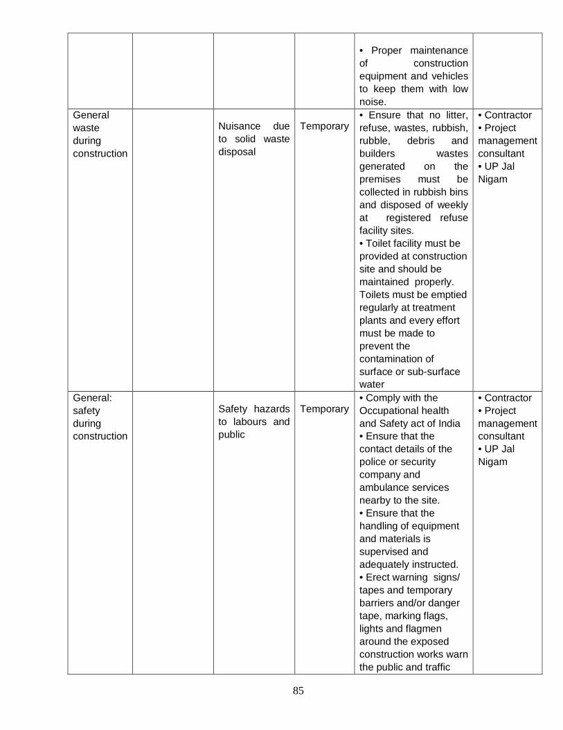
85
• Proper maintenance of construction equipment and vehicles to keep them with low noise.
General waste during construction
Nuisance due to solid waste disposal
Temporary • Ensure that no litter, refuse, wastes, rubbish, rubble, debris and builders wastes generated on the premises must be collected in rubbish bins and disposed of weekly at registered refuse facility sites. • Toilet facility must be provided at construction site and should be maintained properly. Toilets must be emptied regularly at treatment plants and every effort must be made to prevent the contamination of surface or sub-surface water
• Contractor • Project management consultant • UP Jal Nigam
General: safety during construction
Safety hazards to labours and public
Temporary • Comply with the Occupational health and Safety act of India • Ensure that the contact details of the police or security company and ambulance services nearby to the site. • Ensure that the handling of equipment and materials is supervised and adequately instructed. • Erect warning signs/ tapes and temporary barriers and/or danger tape, marking flags, lights and flagmen around the exposed construction works warn the public and traffic
• Contractor • Project management consultant • UP Jal Nigam

86
flow of the inherent dangers. • Provide adequate safety precautions such as helmets, safety shoes, gloves, dust masks, gumboots, etc.
Constructio n camps (if adopted)
Nuisance due to absence of facility of sanitation and solid waste management
Temporary Labour camps are not required, if the labours are from the native place. If labours are not from native place, than following measures must be undertaken: 1) The camps must be not be in an environmentally sensitive area such as in close proximity to a watercour se, on a steep slope or on erosive soils. 2) Camp sites will have adequate provision of shelter, water supply, sanitation and solid waste management as far as practicable.
• Contractor • Project management consultant • UP Jal Nigam
C. Operation phase Sewer line Leakage/
overflows Water pollution and possibility of mixing with water supply line
Permanent There is a temporary concern of leakages and overflows leading to flooding of adjacent areas in the sewerage District ‘B’ (screening checklist). However this can be mitigated and managed by: • Regular monitoring of sewer line and manholes for visible leakages/ overflows. • Immediate repair operation for the damaged portion of sewer line. • De-siltation of blocked sewers/ manholes with sewage pumping
• Jal Santhan • UP Jal Nigam

87
machinesstoring and disposal at appropriate refusal area after treatment. • Ensure proper covering of manhole and avoid dumping of solid waste to prevent chocking of sewer line.
Sewage pumping station
Noise pollution from operation activities
Permanent • Proper handling and regular maintenance of operating machines including pumps, generators, air diffusers, etc.
• Jal Santhan • UP Jal Nigam
General Waste Sanitary
condition s at constructi on camps and site.
Contamination of water resources, blockage of storm drains, bad odour, Health hazard and public nuisance
Temporary • Ensure regular monitoring of provision of water supply, excreta and solid waste management. • Waste should be emptied regularly at disposal area until the work is completed. • Maintaining proper hygienic environment in and around camps and site by regular surveillance and monitoring of waste.
• Jal Santhan • UP Jal Nigam
General Safety Workers
exposed to toxic gases in sewers and hazardous materials in sewage during maintenance work
• Serious/health/ safety hazards
• The toxic gases are likely to contract communicable diseases from exposure to pathogens present in the sewage.
Temporary • During cleaning/ maintenance operation, the sewer line will be adequately vented to ensure that no toxic or hazardous gases are present in the line. • Gases present in the sewer line should be analysed for hazardous/toxic gases before commencing cleaning operation. • Provision of adequate safety precautions such as helmets, safety shoes, gloves, dust masks, gumboots, etc. during maintenance operation
• Jal Santhan • UP Jal Nigam

88
7.2 Social Management Plan
7.2.1 Social mitigation plans during construction phase
Based on the identified social issues, doable mitigation plans are proposed. Some of these measures are already listed in the DPRs, and some of them are additionally recommended for social development of the project and the concerned stakeholders.
i. Impact on human health
Mitigation Measure: Acoustic enclosures or hoardings can be constructed at the proposed sites
Mitigation plan involves the erection of temporary enclosures around construction sites. These barriers will help entrap some of the dust that is brought up in digging. They will also provide safety benefits, to be detailed below. According to the interaction/consultation with the key stakeholders, it was said that contractors are doing water sprinkling in the construction area.
ii. Traffic Congestion
Mitigation Measure: Re-route traffic whenever possible and employing traffic police to manage the traffic movement. Traffic must be re-routed to facilitate ease of movement. Proper signage should provide detailed information on the dates and duration of road closures and which detours will be available, ideally well in advance of actual construction so residents can plan accordingly. Strategic placement of traffic police at critical intersections will also facilitate better flow of traffic. Plans and budget for these measures are already included in the DPR.
iii. Impact on livelihood
Sewer constructions will invariable lead to road closures, which will adversely affect shops on those streets. The first priority is for the contractor to take the necessary measures to ensure that pedestrians always have access to shops, vendors, etc. For mobile vendors, this may include adjusting the location of the cart, etc. to a similar location in the immediate vicinity of the original location for the duration of the project. Projects should also proceed on schedule so as to minimize disruption. Additionally, clean-up of debris and clearance of blockages should commence immediately after project completion so as to remove any potential obstacles that might prevent customers from accessing businesses or other disruptions.
In the event that the contractor, despite best efforts, is unable to avoid blockages of the roads and/or disruption of local businesses, some compensation is necessary. The ESMF currently mandates compensation only in the case of permanent livelihood loss or displacement and provides no provisions for livelihood loss of mobile vendors. Additionally, no regulation, policy, guideline, etc. exists which can provide precedent or guidance in this instance. ESMF clearly states that mobile/ambulatory hawkers: fruit cart vendors, etc. who can easily relocate fall into this category. These vendors are most eligible for a temporary relocation just outside the construction area, and will thus not be eligible for compensation as is the case for this proposed project. However if during the construction of the project any party faces livelihood loss due to the proposed project, then that party should be compensated according to the entitlement matrix given in the ESMF report.
iv. Impact on existing utility services
Mitigation Measure:
89
• Circulating the layout plans of the existing underground alignment near the work site.
• Contacting the relevant department in case there is any damage to any of the utility services and ensuring prompt fixing/replacing of damaged infrastructure
Temporary shifting of power/water lines for construction purposes is already budgeted for in the DPR. Nevertheless, all construction personnel must receive detailed layout plans of existing underground structures to prevent accidental water/electricity supply disruptions. The relevant departments should also be made aware of the timing and location of digging near supply lines so they can make the necessary preparations to respond swiftly to disruptions.
v. Safety hazards
Mitigation Measure: Fencing of the excavation site and providing proper caution sign boards.
As mentioned above, fencing should be erected around construction sites and appropriately marked with caution signage. These fences/signs should remain in place even if construction is not active, so long as a hazard (e.g. open pit) remains. Currently, no provision for fences are explicitly mentioned in the DPR, and, in field visits to JNNURM sites, some had fences while others did not.
vi. Elevated Noise Levels
According to UP Jal Nagham officials, construction will take place after school hours or at other times of school closing to avoid interfering with school function. Beyond that, construction must simply proceed in a deliberate and judicious manner to avoid unnecessary noise pollution.
vii. Failure to Restore Temporary Construction Sites
As mentioned above, provisions to rehabilitate roads and clear debris are already included in the DPR.
viii. Public Notice: according to the suggestion given by locals during the interview. Government and contractor should give a prior notice to each and every locality with the details of project, street wise start date of construction and street wise end date of construction, contact person during emergency. This information would help them better adjust to the situation and make necessary adjustments and provisions.
ix. Health Programme for Workers: If un-sanitary conditions prevail at workers camp, health programmes for their well-being should be implemented.
7.2.2 Social mitigation plans during operation phase
Noise pollution due to improper handling of machines: proper O&M should be carried out during the operation phase to ensure least disturbance is caused to the neighbouring residents.
7.2.3 Mitigation measures adopted by locals during similar nature of project activities
From the field surveys and interviewing the locals including shop-owners, residents, mobile vendors, following local adaptive measures have been recorded;
Using transparent plastic sheets to block entry of dust into shops
Avoiding opening of windows, especially when the construction is going on

90
Taking different routes if possible to avoid areas where construction is happening
Laying wooden plank over the excavated pits for making access route to house or shops
Mobile vendors stated that they place their carts at some other place and vacate construction area for the time when construction is on
Many public institutes like hospitals, schools and colleges reported that they have more than one gate which makes the access easier during construction period.
The above measures indicate that the general public has already created adaptation measures to sewage construction projects.
Public Grievances
Locals also reported few instances where they lodged complaints about un-cleared debris, or damage of public utility generally to UP Jal Nigam officials. They usually do not lodge complaints due to the prior experience of the lack of response from government officials. Additionally, the interviewees said that they understood the inconveniences were of a temporary measure and are providing a social good. Thus, they have created local adaptation measures as quick and efficient ways to mitigate the temporary inconveniences. However the proposed project has grievance redress mechanism which will be adopted as mentioned in the Environment and Social Management Framework.
Table 7.2 Social Management Plan Activity Potential
Negative Impact/Concern
Mitigation Measures Cost Issues
I. Sewerage and Sanitation Projects
A. Design and Development Phase Land Acquisition for new pumping station
NA • SPS is planned on land already owned by the government and confirmed by the Revenue department
NA
B. Construction Phase Laying of sewer network *
Safety hazards to workers and residents
• Provide workers with adequate safety equipment such as helmets, safety shoes, gloves, etc.
• Fences/temporary enclosures should be put around construction sites (even inactive ones, if hazards, like open pits, remain); enclosures should be properly marked with caution signs
• Safety gear already provided by contractor
• Putting fences or other barricades to demarcate the area, is already being done
DPR for Sewerage system in Sewerage District ‘

91
Dust generation, with resulting implications for human health
• Water sprinkling, removal of excess materials, cleaning of sites upon completion of activities.
• Construction of temporary enclosures to entrap dust.
• Water sprinkling
Reduced pedestrian and vehicle access to residences and businesses, with inverse effects on livelihoods
• Work should proceed on schedule so as to minimize road closures
• Upon project completion, quick clearance of debris, etc. will facilitate access by customers to local business and residents to their households
• NA
Debris clearance budgeted for in DPR
DPR for Sewerage
system in Sewerage District ‘B’ Allahabad, Volume.- I, page no. 152
Temporary water , electricity, supply interruptions
• Circulation of layout plan for all underground infrastructure to ensure that contractor is aware of water/electricity lines in construction zones
• Local utilities should be made aware of timing/location of all construction, enabling them to respond swiftly to supply disruption, especially in the event of flooding, etc.
• Provision for temporary shifting of water/power lines, etc. already in DPR
DPR for Sewerage system in Sewerage District ‘B’ Allahabad, Volume.- I, page no. 152
Increased traffic inconvenience (emissions, congestions, longer travel times)
Use of alternate traffic routes; signage should clearly indicate dates of road closures and new routes so residents can plan accordingly
Placement of traffic officers at busy intersections to facilitate easy of movement
Provisions for traffic diversion, with signage already in DPR
DPR for Sewerage system in Sewerage District ‘B’ Allahabad, Volume.- I, page no. 152
Impact to daily life
Prior public notice indicating the date of start of construction and end date of construction should be provided road-wise to the locals, allowing them to make adjustments accordingly
Note: *** denotes – Significant Impact; ** Denotes-Moderate Impacts and *- Minor Impact
7.2.4 Consultation Framework for Participatory Planning and Implementation of Mitigation Plan

92
Relevant stakeholders, especially community members (residents, shop owners, etc.) may be informed about the details of the proposed mitigation plan. A public consultation may be conducted where the mitigation plan is presented, and feedback solicited from the community. Individual meetings with other key stake holders – government officials, relevant NGOs, etc. – could be scheduled to solicit their feedback as well. Once construction begins and the mitigation plan is put into effect, third party audits should be taken up so as to evaluate the efficacy of the mitigation plan, as well as gauge local sentiments related to the construction and identify/address new issues that may have arisen during construction. Stakeholders that should be involved in planning and implementation of the mitigation plan include;
All affected persons (APs), program beneficiaries, including representatives of vulnerable households;
decision makers, policy makers, elected representatives of people, community and citizens, NGOs etc;
staff of executing agency, implementing agencies, GPCU, etc
officials of the revenue departments, social welfare department etc; and
Representatives of the various state government departments, as required.
7.2.5 Assess the Capacity of Institutions and Mechanisms for Implementing Social Development Aspects and Social Safeguard Plans; Recommend Capacity building measures
Roles and functions of the institutions are pre-defined, but they can enhance their capacity for better implementation and operation of the project. There should be synergies and continual interaction amongst the departments for better coordination. The officers of the relevant departments can be trained in social sciences, social management plan, etc.
Institutional reform and capacity building of local body is in process under JNNURM, it will be required to ensure that operating authorities have the ability and equipment to properly manage and finance the operation and maintenance of sewerage schemes. Otherwise continued development will not be sustainable.
Table 7.3 Role of stakeholder in implementation and mitigation Stakeholder Category Role in project implementation Role in mitigation NGRBA Over all coordination Coordinating so that the mitigation
plan is implemented well Ensuring funds for mitigation plan execution
Executing agencies (UP Jal Nigam, Ganga Pollution Control Unit)
Implementation of the project by awarding the project to the suitable contractor and regional coordination Informing the relevant departments about the progress of the project
Ensuring that the relevant departments are available for mitigation plan Enough safety provisions are available for the project implementation.
Jal Sansthan While execution of projects related to sewerage line, Jal Sansthan is
Should ensure that the basic amenities are in order during the

93
responsible for the damage caused to the public utility functions like drinking water pipe lines
construction and operational phase of the project
Municipality Ensuring better access to households
Should ensure all the households envisaged at project planning phase gets access to the services. Weaker section of the society should get equitable share.
State, local Government
Coordination Monitoring and evaluation
Coordination Monitoring and evaluation Ensure all the safeguarding plans are in line and acted upon.
NGOs, CSOs, Research Institutes ( Allahabad University)
Awareness creation about the project activities Community participation for better project implementation
Public participation and coordination
7.2.6 Develop Monitoring and Evaluation Mechanisms to Assess Social Development Outcomes
Regular monitoring and evaluation of the project activities should be carried out to judge its success or any gaps. Certain key parameters can be taken as the benchmark for monitoring and evaluation of the project based on the identified development outcomes. Some of the indicators are listed below;
Increase in sewer access (number of households linked to the sewer network)
Decrease in effluent discharge into the Ganga (water quality assessment of the river)
Proper sites for industries, building etc.
Accessibility of the service to backward and weaker sections of the society
Increase in public toilet
Increase in the land rate (property appreciation value)
Decrease in water borne disease incidence in the area
7.3 Cost information of EMP
Table 7.4 gives a brief idea about the probable cost implications of the environmental management plans. These costs are to be considered as estimated on a lump-sum basis, since the detailed cost estimates depend on site condition and construction/operation practices.

94
Table 7.4 : Cost information of EMP
Phase Component of EMP
Mitigation measure
Cost included
in the DPR
(Yes/no/not clear)
Cost in Rupees
(or Details if provided
in DPR)
Remarks
Design and Development
Provision for accidental leakages / bursts in STP/SPS
Proper drainage arrangements to prevent water stagnation/ flooding in STP/SPS site area
Yes (not specific but included as a part of associated construction activity)
DPR for Sewerage system in Sewerage District ‘B’ Allahabad,
The proposed DPR includes these activities
Location of SPS Appropriate siting, and enclosing within building to reduce noise and odour nuisance to surrounding area
Yes DPR for Sewerage system in Sewerage District ‘B’ Allahabad,
The proposed SPS will be indoor which will prevent noise and enclosed nature and appropriate cleaning and maintenance will prevent odour nuisance
Construction
Excavation, Cutting and filling operations
Review of existing infrastructure, shoring trenches, reinstatement/ resurfacing
Yes DPR for Sewerage system in Sewerage District ‘B’ Allahabad,
The proposed DPR includes these activities
Damage public utilities
Proper reviewing of existing drawing s of utilities, informing concern
Yes DPR for Sewerage system in Sewerage District ‘B’ Allahabad,
The proposed DPR includes these activities
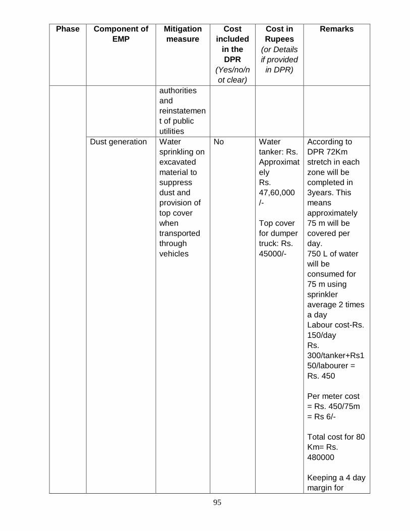
95
Phase Component of EMP
Mitigation measure
Cost included
in the DPR
(Yes/no/not clear)
Cost in Rupees
(or Details if provided
in DPR)
Remarks
authorities and reinstatement of public utilities
Dust generation Water sprinkling on excavated material to suppress dust and provision of top cover when transported through vehicles
No Water tanker: Rs. Approximately Rs. 47,60,000 /- Top cover for dumper truck: Rs. 45000/-
According to DPR 72Km stretch in each zone will be completed in 3years. This means approximately 75 m will be covered per day. 750 L of water will be consumed for 75 m using sprinkler average 2 times a day Labour cost-Rs. 150/day Rs. 300/tanker+Rs150/labourer = Rs. 450 Per meter cost = Rs. 450/75m = Rs 6/- Total cost for 80 Km= Rs. 480000 Keeping a 4 day margin for

96
Phase Component of EMP
Mitigation measure
Cost included
in the DPR
(Yes/no/not clear)
Cost in Rupees
(or Details if provided
in DPR)
Remarks
construction and reinstatement of the site 4x480000= Rs. 1920000/- For 240km stretch: Rs. 57,60,000/- Top cover: Approximately 30 Sqm of top cover may require for each vehicle. Assuming 5 such vehicle involved in transporting excess soil to dumping location (considering construction schedule and max excavated earth disposal). Hence 5 trucks* required top cover 30 Sqm* Cost of Tripol cover at Rs. 100/ Sqm
Noise and vibrations
Usage of sound barriers or sheets.
No. Rs. 9,29,850/-
As per the schedule, the construction of 80km in 3zones each has to be executed in 36

97
Phase Component of EMP
Mitigation measure
Cost included
in the DPR
(Yes/no/not clear)
Cost in Rupees
(or Details if provided
in DPR)
Remarks
months For providing sound barriers like GI sheets, 4Km out of 80 Km of stretch of sensitive zones in sewer work is considered assuming excavation, construction and backfilling activity will take place simultaneously at different stretches. Considering 302 GI sheet of 10’X 4’ would cover 75m length (both sides) of construction activity daily. Hence 302 sheets* Cost of GI sheet Rs.1000 per sheet (Rs.70-100 per Kg)* labour cost ( two labours at avg. rate of Rs. 150 per day) = Rs. 309950 And for 240 Kms = Rs.

98
Phase Component of EMP
Mitigation measure
Cost included
in the DPR
(Yes/no/not clear)
Cost in Rupees
(or Details if provided
in DPR)
Remarks
9,29,850/- Temporary flooding or , water logging
Alternate traffic re-routing, Ensuring storage of excavated soil material on the higher lying areas
Yes DPR for Sewerage system in Sewerage District ‘B’ Allahabad,
Increased traffic inconvenience
Traffic re-routing
Yes DPR for Sewerage system in Sewerage District ‘B’ Allahabad,
Safety hazards to workers and residents
Putting fences or other barricades to demarcate the area
No Rs. 67,500
Assuming a stretch of 75m per day, 150 rods will be used, @ Rs. 300/- per rod.
Labour camps (if adopted)
Health hazards and nuisance due to absence of facility for sanitation or solid waste management
Sanitation No Cost of construction of pit and toilet building approximately Rs. 27,50,405/-
Total no. of labour is estimated assuming 35% of total project working for avg.22 months .The labour camps can be divided into1 camps for each zone, for appropriate management and maintenance work.

99
Phase Component of EMP
Mitigation measure
Cost included
in the DPR
(Yes/no/not clear)
Cost in Rupees
(or Details if provided
in DPR)
Remarks
A toilet with septic tank is been suggested for sanitation facility at labour camps. Pit: Assuming single pit of 45cum would cover 600 people. Construction of one pit would come approximately Rs. 149200/-. Construction
of toilet building (consisting of 15 toilets) would come approximately Rs. 80,000/-
Water Supply
No Approximately Rs. 1146188/-
The suggested sanitation facility will be utilized/ operated depending on the availability water supply facility, which is also important for other domestic purpose.

100
Phase Component of EMP
Mitigation measure
Cost included
in the DPR
(Yes/no/not clear)
Cost in Rupees
(or Details if provided
in DPR)
Remarks
Water can be sourced from existing municipal water supply system and can be supplied through provision of stand post in the camp. The cost of water supply= cost of construction of water supply system* water supply charges (Rs. 2.5/ Kl in Allahabad)
Dust bins No Approximately Rs. 135680/-
Solid waste generation: Generally about 200 grams of solid waste is generated per 5 persons every day. Hence two cluster dustbin (one for biodegradable waste and one for non-biodegradable waste of 1 cum size at the rate of Rs. 2000/-) may handle solid waste generated.
Total cost for EMP is estimated to be approximately Rs. 9474622.35/-

101
Chapter 8 Social Development Outcomes and Issues 8.1 Social Development Outcomes of the sub project
Access to sewer network: This service will cater to the projected population until the year 2050. According to the DPR, population is expected to increase from 216176 in 2011 to 386700 by 2050. In this time, waste water generation is expected to increase from 34.00 MLD to 59.94 MLD. Hence the increase sewerage will prevent outflow of waste water to the Ganga.
Better hygienic conditions: The sewerage network will provide improved environmental conditions due to the contained handling of wastes, leading to improved public health conditions and will likely reduce the average medical expenses of the residents in the project areas. According to DPR this area has sewerage system but the sewers are very old, under capacity and deteriorated condition, which causes significant flow of untreated sewage into river and also this sewage gets accumulated on road/drain sides. These areas suffer from powerful odors and greater amounts of flies/mosquitoes, which will be mitigated with the sewerage connection and overall improvement in environment and health is anticipated from this project.
Decrease in water pollution: Because of the sewer line connection, all the waste water will be collected and directed to treatment plant, which only after treatment will be disposed off to the river, hence decreasing the pollutant load in the river. Due to current pollution, water quality in the river Ganga is impaired at the City of Allahabad. As the water enters Allahabad (at Rasoolabad) from Kanpur, it has a BOD much higher than the safe bathing limit of 3mg/L at about 4.5 mg/L. Downstream from Allahabad (post Sangam and before Assighat, Varanasi), the BDO reduces to below the safe bathing limit20.
Increase in aesthetic value of the project area: connection to sewer lines enhance the aesthetic value of the area, as there will be more cleanliness and no wastewater discharge to open area. This will also lead to appreciation in the property value. This will eventually lead to increase in standard of living of the people in the project site. The support for this statement comes from the counter-factual scenario observed in areas with only nalas (bad odor, insects, etc.).
Reduction in cost of implementation: According to DPR, wherever possible development of sewerage will be integrated with existing GAP infrastructure to reduce the overall investment cost.
Cultural sentiments: Proper sewage disposal would increase the river water quality. As the holy river is attached to many rituals and customs, enhanced river water quality would connect to sentiments of the people. Especially during ‘KumbhMela’ better water quality for bathing would be boon for pilgrims. At present as recorded by UP State Pollution Control Board river water at Allahabad has high fecal coliform concentration, and it has been reported that some sadhus and saints protest against the river pollution and boycott the ritual bathing21. This could be sorted out with better river water quality.
8.2 Social Development Issues in Project Vicinity and Social Services to be provided by the project
102
The social benefits of the proposed project are given above. The social services required to ensure that these benefits are realized are given below:
Ensure backward section of the society gets the facility: Some residents complained that they did not feel they personally would benefit from the project as their houses did not have sewer connection. Thus, increasing household connections will ensure that project benefits are equitably distributed. Plans for increasing connections are detailed in the DPR that is by 2025 coverage would increase to 75% from 45% of 2010 ratio. Special care should be taken to ensure access for backward and vulnerable sections of the society. Full benefits of the facilities proposed under DPR cannot be realized unless a programme to improve coverage of branch sewers and household connection is carried in parallel.
Increasing public toilet facilities: Similarly increasing public toilet facilities will ensure that residents of Allahabad without permanent housing and tourists (especially visiting during ‘KumbhMela’ are able to benefit from the increased sewerage access. Increasing toilet access will decrease practices such as Open Defecation. This eventually would lead to better water quality and would have better environment and social ramifications.
Targeting of economically weaker communities: for construction jobs related to sub-project: In order to ensure that the economic benefits of the sub-project is felt by those in need, those from backward communities should be specifically targeted for relevant jobs.
Proper clean-up of project debris: In order to maximize aesthetic benefits and ensure that debris does not clog sewer path, proper clean-up of project areas must be performed after the project is completed. Collection and disposal of debris is essential for proper function of other essential processes like traffic routing, pedestrian pathways, and clearance of dust and particles causing pollution. Clean area will also enhance the aesthetic value and increase the property rate of the area.
Sanitation for slum dwellers: Allahabad district has many slums, as mentioned above around 185 slums spread across the city. District ‘B’ also has number of slums. All these slums have no legal rights over land so it is not possible to provide such services to them. But their unsanitary condition is an impediment for over all sanitary development. Hence they should be provided with the scheme of low cost sanitation technologies without sewerage connection.

103
Chapter 9 Conclusion The project report of the proposed sub-project for sewerage District ‘B’ of the Allahabad city after environment and social analysis concludes that the project falls in ‘low impact’ category and have overall positive benefits on the life and environment of the people. There has been no reported land acquisition or livelihood losses to be caused under this project. As per environmental and social management framework guidelines of NGRBA, Environmental and Social Assessment, with a Generic Safeguard Management Plan was conducted for addressing possible issues/ concerns arising from proposed project.
Impacts of activities identified during the assessment fell under two separate categories of Construction and Operation. Although no such permanently negative or adverse environmental or social impacts were identified, there were certain temporary impacts, for which appropriate mitigation plans have also been suggested. The environmental management plan ensures to suggest appropriate mitigation measure against the issues/ concerns identified during the environmental and social analysis study. All the social and environmental issues were appropriately studied and have been substantiated using appropriate evidences, to ascertain the magnitude of their impacts. Even the issues of public grievances and public notice have been taken care in the report to confirm transparency during the project implementation. Report also ensures that well defined institutional mechanism is in place to monitor and evaluate the progress of the project during construction, implementation and operation phases.
Stakeholder consultations, and interviews helped to understand the general perception of public towards the project and it can be determined that the people of the project site are happy and welcome such an initiative for their betterment. It was also pointed out that the large overall environmental benefits of the project such as prevention of discharge of untreated sewage into River Ganga, improvement in sewerage collection and treatment, prevention of untreated liquid waste infiltrating into ground water and soil, improvement in quality of life, human dignity and increased productivity greatly outweigh the temporary inconveniences faced during the implementation stages.

104
Annexure 1: Questionnaire TERI-Water Resources Division Date:__/__/2013
NGRBA Project Impact Assessment
Interviewer:__________________
Site: __________________________
Interviewee:________________________
Location: Residential____Public Place_______
For PP: Park______Office____Market__School____Store______Religious place____
Classification:
Resident______ShopKeeper___StreetVendor_____Officeworker____School_______pedestri
an___
Religious figure_____Other_______
1. Are you aware that this project will be constructed?
2. Do you think it is necessary to have this kind of project? You feel connection to sewerage is important?
3. Will your household be connected to sewer line?
4. What do you think will be the consequences of the construction this project on the following: (classify as short term and long term impacts)
a. Traffic blockages?
b. Parking?
c. Aesthetic value of neighbourhood/ environment sanitation
d. Health
e. Access to river water source
f. Noise?
g. Pollution? Dust, air quality, leakages
h. Smell/flies, etc.?
i. Basic services? Drinking water pipes, electricity poles, etc.

105
j. Livelihood? (temporary or permanent)
k. Family?
l. Daily Life?
m. Impact of worker’s camp (unsanitary conditions there, safety concerns, etc.)
n. Other?
5. What do you think will be the consequences of this project, post completion?
a. Pollution?
b. Smell/flies, etc.?
c. Access to river water source
d. Basic services? Drinking water pipes, electricity poles, etc.
e. Livelihood?
f. Family?
g. Daily Life?
h. Other?
6. Are you aware of similar projects (prompt Jnnurm projects) in your area/neighbourhood?
7. How are you coping up with these difficulties?
a. Traffic blockages?
b. Parking?
c. Aesthetic value of neighbourhood
d. Health
e. Access to river water source
f. Noise?
g. Pollution? Dust, air quality, leakages
h. Smell/flies, etc.?
i. Basic services? Drinking water pipes, electricity poles, etc.
j. Livelihood? (Temporary/permanent)
k. Family?

106
l. Daily Life?
m. Impact of worker’s camp (unsanitary conditions there, safety concerns, etc.)
n. Other?
8. Have you/or anyone you know of have complained on any similar projects in the past?
9. What are your suggestions on improving the project construction/operation phase?
10. Are you aware of what will happen in the absence of the project?
11. Do you think this is a no regret investment by GoI (explain what is no regret investment) and more such projects should be implemented?
12. Do you perceive any conflicts during implementation/construction of the project? (get details)
13. Do you know of any conflicts in the past due to similar projects?
14. Do you know of any land acquisition for this project?
15. Do you know of any rehabilitation/resettlement that might be required during project implementation phase?
16. Do you think these projects; will help in improving Ganga river quality, if replicated and upscaled in different areas or not?
17. Are you aware of any community/social movement against this upcoming project?
18. Are you aware of any community/social movement/ cultural issues/security threats (due to labour migration) against similar projects in your area in the past?
19. Are you willing to cope with the temporary disruptions/disturbances during the construction/operational phase? (Prompt and get reason for willingness to cope, if answer is yes/no)
20. Do you believe that the authority will implement the project in a timely and efficient manner?
21. Have you/or anyone you know of approached the public grievance authority in the past regarding similar projects? (note down details)
22. Do you feel this project has minimal/no impact in comparison with some other projects/programmes you know of in the region?

107
Annexure 2:

108
Annexure 3: Census Data District Allahabad (45), Uttar Pradesh (09)
Population Persons 4,936,105 Males 2,626,448 Females 2,309,657 Growth (1991-2001) 26.72 Rural 3,729,320 Urban 1,206,785 Scheduled Caste Population 1,065,097 Percentage to total Population 21.58
Literacy and Educational level
Literates Persons 2,506,942 Males 1,635,387 Females 871,555
Literacy rate Persons 62.11 Males 75.81 Females 46.38
Workers Total workers 1,671,349 Main workers 1,106,596 Marginal workers 564,751 Non- workers 3,264,756 Scheduled Castes (Largest three) 1. Pasi 304,424 2. Chamar etc. 402,347 3. Kol 106,164 Religions (Largest three) 1. Hindus 4,284,834 2. Muslims 627,735 3. Christians 9,114 Important Towns (Largest three) Population 1. Allahabad (M Corp.) 975,393 2. Allahabad (CB) 24,137 3. Lal Gopalganj Nindaura (NP) 22,992 House Type Type of House (% of households occupying) Permanent 50.7 Semi- permanent 45.5 Temporary 3.8 Number of households 740,941

109
Household size (per household) 7 Sex ratio (females per 1000 males) 879 Sex ration (0-6 years) 917 Scheduled Tribe population 4,273 Percentage to total population 0.09 Educational Level attained Total 2,506,942 Without level 152,585 Below primary 536,398 Primary 542,568 Middle 404,832 Matric/Higher Secondary/Diploma 616,060 Graduate and above 254,138 Age groups 5-4 years 586,483 5-14 years 1,374,513 15-59 years 2,598,662 60 years and above (incl. A.N.S.) 376,447 Scheduled Tribes (Largest three) 1. Generic Tribes etc. 3,322 2. Tharu 870 3. Jaunsari 57 Amenities and infrastructural facilities Total inhabited villages Amenities available in villages No. of Villages Drinking water facilities 2,783 Safe Drinking water 2,783 Electricity (Power Supply) 2,289 Electricity (domestic) 1,066 Electricity (Agriculture) 703 Primary school 1,733 Middle schools 613 Secondary/Sr Secondary schools 214 College 61 Medical facility 651 Primary Health Centre 53 Primary Health Sub- Centre 66 Post, telegraph and telephone facility 910 Bus services 201 Paved approach road 1,956 Mud approach road 1,986

110
Annexure 4 – Water quality Data of river Ganga & Yamuna during Kumbh Mela 2013