The Mountain Potters of Buncombe County, North Carolinarla.unc.edu/NCAC/Publications/NCAC_26.pdf ·...
109
The Mountain Potters of Buncombe County, North Carolina: An Archaeological and Historical Study by Linda F. Carnes-McNaughton North Carolina Archaeological Council Publication No. 26 1995
Transcript of The Mountain Potters of Buncombe County, North Carolinarla.unc.edu/NCAC/Publications/NCAC_26.pdf ·...
The Mountain Potters of Buncombe County,North Carolina:
An Archaeological and Historical Study
byLinda F. Carnes-McNaughton
North Carolina Archaeological CouncilPublication No. 26
1995
The Mountain Potters of Buncombe County,North Carolina:
An Archaeological and Historical Study
byLinda F. Carnes-McNaughton
North Carolina Archaeological CouncilPublication No. 26
1995

TABLE OF CONTENTS
.... D ..
................................................................................ D ..
..........................................................................................................ABSTRACT •••••••••••••••••••••••••••••••••••••••••••••••••••••••••••LIST OF TABLESLIST OF FIGURESACKNOWLEDGEMENTS
iiiivv
vii
CHAPTER 1: INTRODUcrION ••••••••••••••••••• ................................................ 1
............................................................................CHAPTER 2: PHYSICAL CONTEXTSEnvironment and Vegetation ••.•••.•••...•••.•....••.•.•.•••••.•.••SOils and Petrology ••••••••••.•••••••.•..••.•.•..••.•.....•••...•
333
........................................................................CHAPTER 3: CULTURAL BACKGROUNDHistoric Chronology •.••••.••••••...•..•..••.....••....••.••..•.••Previous Research on Pottery in Buncanbe County .••••.....•.••••••
667
............ ..................................................................................
CHAPTER 4: RESEARCH DESIGN, QUESTIONS, AND MErHODOIDGY ••••••••••••Research Design ..••••.•••••.•••.••.•..••..•••.•••.•••..••••••••••Research QuestionsMethodology •••••••••••.....••.•••••.•••..•.••••..•••••.•..•••••.•
999
11
................................................
..........................................................
..............................................................
1616
1818182734394751515964667377
.............................................. ............................................................................
............................................................................
...............................................................
.............................................
CHAPTER 5: RESULTS OF HIS'lDRICAL AND ARCHAEDLOGICAL INVESTIGATIONSExtant Buncombe County Pottery ShopsHistorical and Archaeological Investigatiolis of
Ten Buncombe County Pottery SitesCandler Area Settlement
Stone/Penland Site (3IBn387)Trull Site (3lBn388)Rutherford Site (3IBn389)Bachelder Site (3lBn386)Fulbright Site (3IBn390)
Weaverville Area Settlement •••.••....••••.•••..•••••••••••••.Denkel Sites (3IBn381 and 3lBn382)Denkel Site (Presnell Property - 3lBn38l)Denkel Site (Church Property - 3IBn382)McClure/Yoder Site (3lBn383)Cheek Site (3lBn384)Lankford Site (3IBn385)
................... ..........................................................................
...............................................................................................
8282858586868687
CHAPTER 6: SUMMARY OF ARTIFAcrS FROM EIGHT POITERY SITES ••••••••••Vessels •.•.••...•.••••••••.•••........••.•••••.••••••••.....•••••Non-VesselsKiln FurnitureArchitectural DebrisBy-Products/ResidueMiscellaneous Historic (Da:nestic)Lithics
............................
............................................................................
CHAPTER 7: CONCLUSIONS AND RECOMMENDATIONSAssessment of Site Research ..••.•••••••.•...••.•••.••••••..••...•
.As$~$E;rnerJ:t. Qf'. r!1dividlJa.1 Site Significance •.••••••....•••••.......National Register Significance ReccmnendationsConclusions
8888929396
REFERENCES 97
ii

ABSTRACTAn archaeological and historical survey was conducted on
traditional pottery manufacturing sites located in BuncombeCounty, North Carolina. The twenty-two week project took placeduring Spring and Summer of 1989 and involved two weeks of archival research, ten weeks of fieldwork, six weeks of analysisand report preparation, and two weeks of summation work. Theprimary purpose of the survey was to research, inspect, test, andassess the pottery sites in order to determine their eligibilityfor inclusion on the National Register of Historic Places. Tenpottery manufacturing sites were located and researched, andeight were selected for archaeological investigations based ontheir presumed subsurface integrity and potential. Archaeological investigation consisted of site mapping with a transit,pedestrian surface collecting, and excavations of test unitsacross the site. In summary, three sites yielded subsurface kilnremains, and all sites combined produced over 11,000 artifacts.The information and artifacts recovered from this study providevaluable insight into a century of lifestyles and pottery manufacturing activities by Buncombe County folk potters which beganin the mid-1800s.
iii

List of Tables
1. Soil Types for Ten Pottery sites .•....•..••••........ 5
2. Artifact Categories for Analysis .•.....•••...•.•••..•15
3. Early Potters and Associates from13\lllc:()rn1J~ ~()\l1l1:)( 17
4. Buncombe County Pottery sites 19
5. Summary of Artifacts from theStone/Penland site •.........................•••..••..28
6.
7.
8.
9.
Summary of Artifacts from the Trull site •••••••••••••33
Summary of ·Artifacts from the Rutherford site ............ ... 38
summary of Artifacts from the Bachelder site ................ .48
Summary of Artifacts from the Donkel(Presnell) site .......................................................................... . 63
10. Summary of Artifacts from the Donkel(Church) site ......••........•..................•....67
11. Summary of Artifacts from the McClure/Yoder site ....•72
12. Summary of Artifacts from the Cheek site .•••.........78
13. Summary of Artifact Categories fromEight Buncombe County Pottery Sites ..••••.....•.•....83
14. Summary of Production Periods ....•••.......•••••.••••90
15. Summary of Physical Evidence .........•.•........••...94
iv
List of Figures
1. Map of Proj ect Area ............•••...•............•.... 2
2. View of Test unit Excavation .......•....••.•....•......13
3. View of stone/Penland site .••.••.•.••...•.••....•.••.••22
4. View of 1938 Jugtown Shop, Stone/Penland site •..••.•••.23
5. View of Marion Penland at Work 1938 ••.....••....••.•.•.24
6. Profile Drawings of Test Units, stone/Penland site •....26
7. View of Trull Monkey Jug ...........•....•.....•....•...30
8. View of Trull site ••......•.•..••.••.....••......•.•...31
9. Map of Rutherford site ••.....••......•...........••••••36
10. Plan and Profile Drawings, Test Units, Rutherford site .37
11. View of Draw Trial, Rutherford Site ..•..........••.....40
12. View of Non-Vessel Forms, Rutherford site ....•.........41
13. View of Bachelder site •.••.....••......•........••.....42
14 • Map of Bachelder site ......•.•.•...••....•.•.•.....•••.45
15.
16.
17 •
18.
19.
20.
21.
North Profile Drawings, Test units 1-7, Bachelder site .46
View of Albert FUlbright at Work, Brown Pottery .... '" . ..50
View of 1917 Reems Creek Pottery, Donkel Site • .....•..•54
View of 1917 Reems Creek Pottery, Donkel site · .....•. ..56
View of 1917 Reems Creek Pottery, Donkel site · ... '" . '" . '" .57
View of Terra Cotta Vase by George Donkel ............ ..58
Map of Donkel (Presnell) site ... '" .. '" .... '" ....... '" .... ..60
22. Profile Drawings, Test Units,Donkel (Presnell) site ..•.•...........••.......••..•...61
23. Plan and Profile Drawings, Test Unit 17B,Donkel (Presnell) site ••••••.••.•••••••.........••....
24. Map of Donkel (Church) site .•................•..•......65
25. Map of McClure/Yoder site ..•......•....................70
v

List of Figures
26. Plan View of Test unit 7, McClure/Yoder Site .......••••71
27. Map of Cheek site .......•..••....•.......•.......•.....75
28. Plan Drawings, Test units A, B, and C,Cheek site 76
29. View of Reconstructed J.H. Stone Crocks,Cheek Site 79
30. View of Lankford Molasses Jug .••......•••........•••...81
vi
ACKNOWLEDGEMENTS
An earlier version of this manuscript, titled "Archaeologicaland Historical survey of Ten Buncombe County Pottery Sites," wassubmitted in September 1989 to the Historic Resources Commissionof Asheville and Buncombe County and the North Carolina Department of Cultural Resources' Division of Archives and History. Itwas subsequently revised for pUblication in August 1991.
I wish to acknowledge the Historic Resources Commission (HRC)of Asheville and Buncombe County, and the Department of CulturalResources, Division of Archives and History (DAH) , who served asco-sponsors of this certified Local Government Grant. Overallproject administration was guided by Doug Swaim of the HRC.Archaeologist David Moore, DAH, served as Project Specialist. Iwould like to express my considerable appreciation to these twoindividuals and other members of their agencies who had inputinto this project. Valuable references were generously shared byseveral informants during the course of the project. Theseindividual researchers were Rodney Leftwich, Deena Dillingham,Blanche Robertson, Opal Barnes, and Mary Hutchinson. During theproject, numerous intact pieces of Buncombe County pottery wereexamined and photographed from private collections and antiqueshops. I wish to thank Doug and Jane Penland, Ally Goodwin, GeneWilkerson, Loretta Wilson, Dry Ridge Museum, Vance BirthplaceState Historic site, Bailey Lankford, Rodney Leftwich, EdraPresnell, William and Audie Pressley, Opal Barnes, Sue Macelroy,Richard Walker, and Mary Hutchinson for graciously allowing meaccess to their pottery collections.
Field and Laboratory work for this project was conducted witha team of local and regional volunteers supervised by thePrincipal Investigator. I am particularly grateful to the following volunteers and colleagues who gave generously in time andeffort:
Marianne CheekPhil CrollCissy DeaseBobby FarmerMerry FitzpatrickMichael HarmonMary Jean HooperWillie IsraelDale KaukeinenRodney LeftwichRidgeway Lynch
Kirk McNaughtonBob PaceScott RaylJunior RogersLaura ReubenbacherChris SheridanJack SheridanDoug SwaimAnn TippittEd TrevertonPolly Worthy
Special recognition should be given to Ed Treverton, Polly Worthy, Scott Rayl, Bob Pace, Mike Harmon, Kirk McNaughton, WillieIsrael, Dale Kaukeinen, and the Sheridans, who worked severaldays in the field and lab. Analysis of 11,000+ artifacts was·acc6:rnplishedihfourdaysthroughthe·herculearieff6.fts·iri·as....sistance from Polly Worthy (a.k.a. "Ace Analytic Converter").
Report preparation was made possible by the assistance of TomMaher, who prepared Tables 1-15 and assisted in the final
vii

editing. All photographs were made by the author except thoseotherwise noted. The cover photograph of George Donkel at hisshop was taken by William Barnhill in 1917 and appears as acourtesy of Mars Hill College. Photographic plates were preparedby the author with assistance from Nick Lanier, photographer atDAR. All maps and drawings were prepared by the author as well.
I am grateful to Dr. steve Davis with the ResearchLaboratories of Anthropology at the University of North Carolinafor his diligent efforts in getting this manuscript printed, andto Ken Robinson and the North Carolina Archaeological Council forpublication support. Finally, I wish to thank Kirk McNaughtonfor his patience and support throughout this project and fordeveloping a penchant for pottery.
viii
CHAPTER 1INTRODUCTION
During the mid-nineteenth century a few traditional pottersfirst moved into the valleys of Buncombe County and establishedtheir own pottery manufactories. Most of the potters who movedinto the mountainous region near Asheville came from other regions of the state (or from other neighboring states) wherepottery production had already been established. Some originatedfrom Tennessee, Georgia, South Carolina, or the Catawba Valleyregion of North Carolina (Zug 1981:17). The potters brought withthem the skills, technology, and vessel designs developed fromceramic traditions of these other regions. Once transplanted intheir new region, temporal and material modifications of localresources by the potters soon developed into the Buncombe Countyceramic tradition, unique by its own elements. All potters werepredominately stoneware manufacturers, supplemented by the production of earthenwares (terra cottas) used for agricultural orhorticultural purposes.
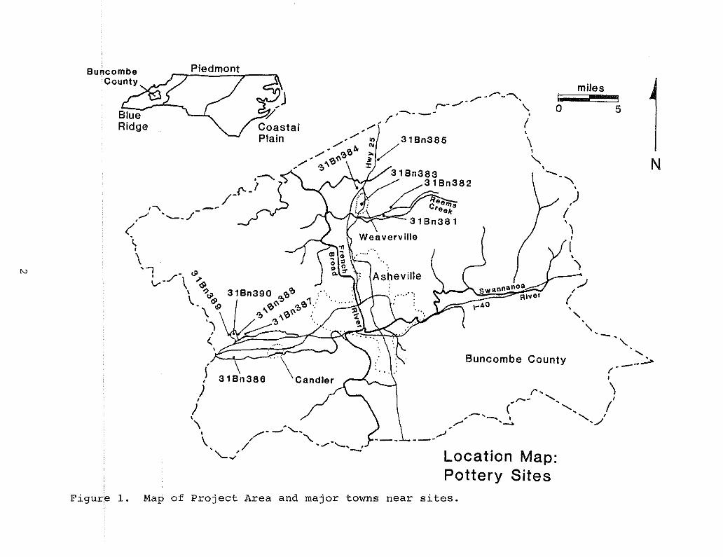
By the late 1800s to early 1900s two communities surroundingAsheville became pottery production centers (Figure 1). Severalpotteries were located near the small town of Candler, south ofAsheville. The other center was located in and around the townof Weaverville, north of Asheville. The availability of naturalresources (clays, water, land, and wood for fuel) in these twoareas, the stability of established communities (with ampleconsumers for their goods), and perhaps, kinship ties were theprimary factors behind these new pottery centers.
This report will present the results of a systematic archaeological and historical survey conducted at ten selected potterysites located in Buncombe County. On April 24, 1989, a $14,000certified Local Government grant was awarded to the HistoricResources Commission of Asheville and Buncombe County (henceforthreferred to as HRC) by the North Carolina Division of Archivesand History, (henceforth referred to as DAH) through funds provided by the National Park Service. The purpose of the projectwas to conduct archaeological investigations at the originalsites of Buncombe County pottery manufactories. This researchgrant called for a 20-week project schedule including two weeksof background historical research, 10 weeks of fieldwork, andeight weeks of report preparation and summation work. Projectobjectives called for archaeological survey and testing at two tofour of the six known pottery sites depending on availability andaccessibility. As it happened, the location of 10 pottery siteswere discovered (or rediscovered), and permission was obtained toexcavate at each. Due to time limitations, personnel, and funding, however, the 10 sites were ranked according to their archaeological potential. This reevaluation narrowed the list to eightsites, the results of which will be forthcoming.-
Personnel involved with this project included Doug Swaim,HRC Project Coordinator, David Moore, DAH Project Specialist, andthe author as principal Investigator. All field and lab assistance was provided by a team of volunteers, local and regional.
1
N
5
'-. '-
a
swannanoa
Buncombe County......
--~,--I
r· \,,-- .......... '
( '. I,,_,_ , ........ I
.../"~ ... ./'..-'---Location Map:Pottery Sites
miles
Asheville
/"-/'----r---/'- \.
,--....- _- I
/_1 (
'" 3160385 \i/ I
x ~\3160383 ~
/3160382 ",
~ ~ee~ ,)Creek' (
3160381 ",I,)
)1/
CoastalPlain
I,),
J\
\ , /-_.. """", ..\ ' \../ .......... -'-... ,'''-.,/ -
Piedmont6uncombeCouoty
Figure 1. Map of Project Area and major towns near sites.

CHAPTER 2PHYSICAL CONTEXTS
Environment And Vegetation
The study areas, located south and north of Asheville, arecontained in the intermontane basin of the French Broad River andits confluence with the Swannanoa River. Asheville's elevationis 2300 feet amsl. This mountainous area is a part of the largerregion known as the Appalachian Summit, a term used by Kroeber in1939 and part of Fenneman's (1938) larger, Blue Ridge physiographic province. The climate in the western mountains of NorthCarolina maintains a cooler scale than the piedmont region,averaging 56.5 degrees mean annual temperature in the valleys and43.3 degrees in the mountains. Latitude and elevation controltemperature variations and these effect the length of growingseasons in valleys and mountains. Rainfall in the mountainregion has been recorded heavy at times in summer and early fallseasons, often resulting in local flooding of the valleys. Meanannual rainfall ranges from 50 to 60 inches (Purrington 1983:92).Snowfall in the region is quite variable, and may range from 8 to30 inches of accumulation, again depending on latitude and elevation.
Vegetation in the main valley floors of the AppalachianSummit, where the study sites are located, consisted of typicalagricultural bottomland species, such as mixed grasses, weeds,blackberry brambles, thistles, and clover. Areas surrounding thesites are mixed mesic oak-chestnut forest, with some pines,sourwood, maple, black locust, beech, and poplar stands noted.Ground vegetation bordering streams consists of ferns, woodsorrels, Queen Anne's lace, vetch, heptica, baneberry, Solomon'sseal, deptford pinks, and phlox, to name a few. Evergreen shrubssuch as mountain laurel, rhododendron, and hobblebush are alsopresent.
The faunal population of the region includes mammals such aswhite-tail deer, black bear, bobcat, wolf, groundhog, rabbits,squirrels, raccoons, fox, beaver, skunks, muskrats, and opossums.Game fowl includes turkey, grouse, and pigeon and some migratingfowl such as ducks and geese. Other bird species such as woodpeckers, titmouse, jays, chickadees, nuthatches, owls, hawks,quail, and eagles are found here (Keel 1976:9). Varieties ofturtles, amphibians, and snakes are common to the area, as wellas game fish such as trout, bass, pike, perch, and catfish.
Soils And Petrology
Soils of the area are directly correlated to the localclimate, topographYi petrologYiand vegetation. Highmountainsoils which occur between 2000 and 3500 feet consist of parentmaterials derived from acidic crystalline rocks (i.e., gneisses,granites, and mica schists), basic crystalline rocks (i.e., diorites, or hornblendes), very micaceous rocks (i.e., talcose
3

schists, or light gneisses), shales, slates, quartz, fine-grainedsandstones, and very localized limestones (Keel 1976:7). Maturity of soil types and their suitability for agricultural purposesare dependent on elevation and location, more specifically,mountain slopes versus valley floors. Typically younger alluvialsoils comprise the valley floors. Although all soils are formedthrough processes of weathering and all clays are ultimatelyderived from igneous rock, the soils at the different sites varyaccording to the nearest drainage system. In most cases modernsoil maps are oriented towards the agriculturalists and the soilsusefulness as farmland, pasture, etc. Immediate deposits of claysuitable for pottery production may often occur between or withinmajor soil divisions. Therefore, the presence or absence ofspecific clay resources (or beds) related to each pottery sitelocation will be discussed later in the text with individual sitedescriptions. Specific soil types for each pottery site locationare provided in Table 1, adapted from the 1977 Soil ConservationService study of Buncombe County, edited by Bailey, et al. Itshould be noted that all but two of the pottery sites containHaynesville/Evard soil types. The two exceptions contain thenext most common soil types in the region.
4

Table 1Soil Types for Ten Pottery Sites
Description/Site Name Location Soil Type Properties
Bachelder Luther Codorus- 0-7% slope, good(31 Bn3861 Comus-Tate agricul., flood pin.
Stone/Penland Jugtown Haynesville 7-25%, fair-good(31 Bn387) Evard agricul., well drain
Trull Big Cove Haynesville 7-25%, fair-good(31 Bn3881 Evard agricul., well drain
Rutherford Big Cove Haynesville 7-25%, fair-good(31 Bn3891 Evard agricul., well drain
Fulbright Big Cove Saluda 25-45%, poor agricul.(31Bn3901 Haynesville poor drainage
Donkel (Presnell) Reems Creek Haynesville 7-25%, fair-good(31 Bn381 I Evard agricul., well drain
Donkel (Church) Reems Creek Haynesville 7-25%, fair-good(31 Bn382) Evard agricul., well drain
McClurelYoder Weaverville Haynesville 7-25%, fair-good(31 Bn3831 Evard agricul., well drain
Cheek Clarks Chapel Haynesville 7-25%, fair-good(31 Bn384) Evard agricul., well drain
Lankford Stockville Haynesville 7-25%, fair-good(31 Bn3851 Evard agricul., well drain
5

CHAPTER 3CULTURAL BACKGROUND
The pottery sites examined during this study were located inthe Weaverville and Candler communities of Buncombe county, whichwas founded in 1791 from portions of what was then Rutherford andBurke counties. The settlement histories of Weaverville andCandler will be presented in upcoming sections. In order tounderstand the historic development of Buncombe County, however,a chronological summary of the surrounding region is essential.
Asheville and the pottery sites are located in a majordrainage basin which has been occupied continuously by peopletraveling along the waterways. Previous archaeological investigations in the regions have dealt specifically, and predominately, with prehistoric human activities and have been summarizedelsewhere (Keel 1976, Dickens 1978, and Purrington 1983). Priorto this project, no archaeological investigations have beenconducted on traditional pottery manufacturing sites. Historicalresearch by several individuals, however, has been done on theBuncombe County potters and will be reviewed later in this section.
Historic Chronology
Recorded history begins with the pUblished chronicles of theSpanish explorer Hernando De Soto who traveled through westernNorth Carolina (and possibly Buncombe county) in 1540. Laterexplorations by Europeans into the area occurred in 1673 whenJames Needham and Gabriel Arthur established trade networks withthe Cherokee Indians, native occupants of the region (Sharpe1948:34). Early trade routes followed preexisting Indian pathswhich traversed the present day location of Asheville, at theconfluence of the French Broad and Swannanoa rivers (N.C. Clipping File 1979:844).
By the onset of the American Revolution, the British haddesignated the limits of colonial expansion westward to be theBlue Ridge Mountains foothills. With this assurance of territorial integrity the Cherokees aligned themselves with the British.Conflicts between the Cherokee and early colonists resulted in amajor confrontation headed by General Griffith Rutherford in1776. He destroyed Cherokee villages and dispersed settlementsof the Indian Nation.
Early settlers were predominately Scotch-Irish immigrantsfrom Ulster in North Ireland, who left to escape failing wool andweaving industries burdened from restrictive British tariffs.The first permanent settlers of the Swannanoa Valley were SamuelDavidson and his family in 1784. The county of Buncombe wasfounded in 1791, and a log courthouse was built in 1793 on whatis now called Pack Square. One year later, a land grant wasobtained by John Burton to layout forty-two half-acre lots for asettlement he called Morristown. In 1797, the town was incorporated and the name changed to Asheville, in honor of GovernorSamuel Ashe. In 1828 a major wagon road was opened along the
6

French Broad River which connected to East Tennessee. Thispassageway helped to dissolve frontier barriers and travel increased in both directions through the mountains. To the south,the Asheville/Greenville Plank Road was completed in 1851 andopened corridors of trade and settlement. In 1840 Asheville'spopulation was around 500; in 1860, 1100; in 1880, 2610; in 1890,10,237; and by 1930, 50,193 (N.C. Clipping File 1979:844).
During the civil War, Asheville served as a Confederatemilitary center. Early industry producing Enfield Rifles keptthe county prosperous. captain Zeb Vance, who later became astate governor, headed up the Rough and Ready Guards. The population of Asheville, no longer isolated from the rest of thestate or nation, began to grow. Its frontier facade began tofade. By the 1880s, Asheville was being billed as a health resort, with its clear mountain air, lush vegetation, abundantstreams, and beautiful vistas. When the railroad was completed,new industry and growth arrived. Construction of luxury hotelsand homes reflected a land-boom lasting into the early 1930s whenthe Great Depression halted these activities. But the creationof two expansive natural attractions, the Blue Ridge Parkway andthe Great Smoky Mountains National Park, provided a road torecovery for the residents of Asheville and Buncombe County (N.C.Clipping File 1979:846).
Previous Research on Pottery in Buncombe County
Prior to this project, no archaeological research had beenconducted on traditional pottery sites of Buncombe County.Extensive historical research on the sUbject, however, has beengoing on since the late 1930s, with pUblication of Eaton's book,Handicrafts of the Southern Highlands, and earlier newspaperarticles from local sources describing works at Penland andBachelder potteries. More recently, research and pUblishedreferences by Pat Johnston and Daisy Wade Bridges in 1984 (on theBachelder pottery), Bob conway and Ed Gilreath's 1974 exhibitioncatalog of North Carolina pottery, and Deena Dillingham's 1981work on the Reems Creek (Donkel) Pottery have provided abundantsite specific historical information. In 1986, Charles Zug, afolklorist at the University of North Carolina, Chapel Hill,published a book entitled, Turners and Burners: The Folk Pottersof North Carolina. This primary text is the only extensivelyresearched document dealing with traditional pottery in NorthCarolina, presented in historical and folklore contexts.
Unfortunately, few of the references previously describedhave provided information regarding the archaeology of suchsites. In the past, only the pottery sites associated with theMoravian settlements in the central piedmont have received archaeological attention. Recently, however, work was begun onpottery sites located in· other regions of the state; In 1986 apreliminary reconnaissance survey of pottery sites in Alamanceand Chatham counties was conducted by the author (Carnes 1986).The survey was done as part of a course requirement, and no fundswere available for in-depth investigations. The purpose of this
7
survey was to locate and test, where possible, nineteenth centurypottery kiln sites. During the project six sites were locatedand two were subsurface tested. The author then chose one of thesites for intensive archaeological investigations, along withanother pottery site located in Lincoln County, in the CatawbaValley region. These two sites were excavated in the fall of1987 and winter of 1988. Together they form the basis forresearch investigating the transition from earthenware to stoneware manUfacturing among traditional potters in North Carolina(Carnes 1988). Excavations at these sites revealed the foundation remains of three kilns, two at the Alamance County site andone at the Lincoln County site. Again, these sites represent theonly known kiln sites to be archaeologically investigated outsidethe Moravian settlement.
These recent efforts in archaeological exploration oftraditional pottery kiln sites have demonstrated the importanceof corroborative evidence in documenting this cottage industry.By studying the physical remains of pottery sites (such as kilnstyles, waster materials, kiln furniture, and site proxemics),archaeologists can provide additional insights into technologicalaspects of ceramic production. Historical and archaeologicalresearch have been successfully combined on other pottery siteslocated in the Southeastern United States (e.g., Castille, etal., 1988; Landreth 1985; Brackner 1981; and Smith and Rogers1979).
Through this county-wide project, an attempt was made tosystematically survey and assess the archaeological potential ofBuncombe County pottery sites. In addition, relevant historicaldata also was collected on each of the potters and pottery sitesto enhance the physical evidence provided by archaeological research. Finally, unpublished notes, photos, and references weregenerously shared by Rodney Leftwich, a local art instructor,potter and collector of Buncombe County pottery. His privatecollection of reference material and local pottery providedvaluable insight into the ceramic tradition of the region.
8

CHAPTER 4RESEARCH DESIGN, QUESTIONS, AND METHODOLOGY
This section will discuss the project objectives, as outlined in the grant's scope of work, and the methodology employedto achieve those objectives. In addition, research questionsrelated to the regional and local significance of the sites,their physical and historical characteristics and their potentialfor nomination to the National Register of Historic Places (as aHistoric District) will be presented.
Research Design
The primary objective of the project was "to conduct archaeological survey and testing investigations at and around two tofour of the following sites depending on availability and accessibility for research: Bachelder, Stone/Penland, Trull, Donkel,Cheek, and Lankford pottery sites." The project was to consistof three phases, conducted simultaneously if necessary. PhaseOne consisted of background research to determine the locationsof the above mentioned properties and their suitability forinvestigations. Phase Two was to select two to four of thesites, and conduct archaeological testing to assess the potentialfor the presence of features and structures, and determine siteboundaries and site significance. This report represents PhaseThree, which summarizes the field results, assesses the sites'potential for nomination to the Register, and offers recommendations for future research.
Because the primary purpose of the project was to assess thearchaeological potential of selected Buncombe County potterysites, determine site boundaries and establish site significance,the operational premise of the survey was basically reconnaissance. site boundaries were determined through testing andmapping. Archaeological potential and integrity were assessedthrough subsurface investigations. Finally, a few questions wereposited to guide research orientation and to help establish sitesignificance.
Research Questions
Research questions of regional concern include:1. How do the Buncombe County potteries differ or
compare to other pottery manufacturing siteslocated in North Carolina (i.e., Catawba Valleyor Central Piedmont), or in other states in thesoutheast (i.e., South Carolina, Georgia, orTennessee)?
2. How do the stonewares manufactured in BuncombeCounty compare in vessel form, paste/glazecomposition, or decoration to wares produced inother regions? Specifically, how does the
9
alkaline glaze found in this region differ fromthat found in Catawba Valley or the EdgefieldDistrict of South Carolina?
3. Do similarities or differences in these waressignal some evidence for the exchange of ideasor people (potters) between the regions?
4. How do the temporal characteristics of BuncombeCounty pottery manufacturing compare to otherregions within the state, and what are thetemporal manifestations of this cottage industry?
Research questions of specific local concern include:
1. Are there identifiable "signatures" or specificattributes for each of the Buncombe Countypotters and their resultant wares?
2. Can specific attributes of each potters' work betraced to more than one site?
Research questions related to the physical characteristicsof each site include:
1. What are the proxemics (locations of kiln, shop,waster pile, etc., in relationship to eachother) of each site and how do they compare toeach other?
2. What type of kiln, workshop, pug mill, or otherequipment was employed at each site and whatconstruction techniques were used?
3. How do the remnant physical structures or sitemorphology reflect the level or nature of production at each site (was it a factory operationor part-time endeavor)?
4. What can be determined about each sites' location and its proximity to the necessary naturalresources (e.g., clay, water, wood, iron ore,glass source,etc.)?
5. How did community settlement patterns and transportation corridors affect pottery site selection by the potter and distribution and marketvariables?
Finally, research questions concerned with the historicalcharacteristics of each site include:
10
1. How does the available historical data from eachsite confirm or contradict the archaeologicalresults?
2. What types of historical information are mostrelevant to carrying out investigations ofpottery manufacturing sites?
3. How does the historical information obtainedthrough oral informants supplement the archivaland archaeological records?
In summary, research questions included documenting, wherepossible, various attributes of each potter's wares, glazes, andkilns, and recording the historical and physical characteristicsof each site. The degree to which the research questions couldbe addressed varied depending on the nature of the question, theresults of archaeological testing and artifact recovery, and thereconnaissance nature of this project. Only ten weeks werescheduled for field work with only one full time archaeologist.
Methodology
The methods for archaeological and historical investigationswere consistent with contemporary professional standards as setforth by the Secretary of the United States Department of theInterior. Two weeks were spent doing archival research togather background information. Priority time was given to fieldwork in order to assess subsurface integrity and site significance vis a vis the National Register of Historic Places. As aconsequence, 10 weeks were scheduled for archaeological testingand no time was specifically designated for artifact analyses.Therefore, artifact analyses received the briefest coverage (fourdays) in the week prior to report preparation. A variety offield testing techniques were employed and will be discussedbelow. Modifications to the field techniques will be explainedfor each site.
Historical and archival research was conducted in the firsttwo weeks of the project, and some additional work was done onrain days and evenings. Research focused on several objectives:(1) to obtain background information on each of the known (andunknown) potters who worked in the county; (2) to determine whenthe potters operated the shops; and (3) to gather general historical information about the communities where the ShopS werelocated. Primary documents (i.e., census records, marriage,birth, and death records, and tax records), were researched atPack Library archives. Land deed records were collected for somesites and old county maps were examined for early roads andcommunity locations. Personal documents, such as family letters,genealogies, photographs, and histories were reviewed whereavailable. Old newspaper articles, exhibition catalogs, andother texts on local handicrafts provided supplemental data. Inaddition, oral interviews with descendants of the potters, or
11

others who worked with them, antique collectors of local pottery,and other researchers contributed valuable insights and materialsto supplement the written archival documents.
As part of background research, an effort was made to photograph extant pottery pieces from private collections which weremarked or known to have been made by Buncombe County potters.These exemplary pieces also aided the archaeologist in learningto recognize unmarked or fragmentary pieces of pottery attributable to a particular potter or shop. Over 100 intact pieces oftraditional Buncombe County pottery were photographed (in blackand white and color). These photographs provide a permanentrecord of ware varieties to supplement the archaeological materials recovered at each site.
Field methods employed during this project were "of SUfficient intensity to establish, within reasonable archaeologicallimits, the presence or absence of site features and structures,"as stated in the scope of work. Ten sites were located by preliminary field inspections and informant interviews. Permissionwas obtained from current property owners to archaeologicallysample each site. Two sites were eliminated from the revisedsite list because of their presumed lack of archaeological potential due to modern landscaping (Lankford site) and/or lack ofconfirmed kiln structure (FUlbright site). Therefore, each ofthe eight remaining sites received the following field inspectiontechniques (or combination thereof):
1. Recovery of surface material through systematicpedestrian reconnaissance.
2. Construction of a detailed site map, inclUdingextant features and structures, location of allarchaeological test units, "memory" data received from site informants/occupants, visiblesite limits, contour variables (recorded with atransit), and placement of a permanent sitedatum.
3. Excavation of a series of subsurface test unitsplaced across the site at regUlar intervals (10,1S, or 20-foot intervals, depending on sitesize), and/or in those areas of greatest archaeological potential if known. Test units on mostsites were 2x2-foot units which were enlarged toSXS-foot or 2x6-foot units if necessary todefine or identify subsurface features. Becausethese sites often occurred in landscaped, grassylawns (on private property) extra care was takento "confine" the excavation units. Sod wasremoved in sections using an edger tool, placedaside and later replaced in its exact position(Figure 2). Large cloth sheets were spread onthe ground adjacent to the test unit to catchscreened dirt from the units. All soil from theunits was screened through half-inch wire mesh.
12

Figure 2. View of Test unit excavation.

ly sterile subsoil, bedrock, or immovable object. Sample profiles were photographed anddrawn for the test units. All arbitrary andcultural stratigraphy intervals were recordedfor each unit as well. Artifacts recovered fromeach excavation unit were bagged accordingly.Screened soil was then replaced into the unit,packed down, and the sod layer put back inplace. Location, corners and elevations of eachunit were recorded for the site map using atransit. In areas where dense vegetation coveredthe suspected site areas, shovel tests wereexcavated, using the same excavation, backfilling, and recording procedures. Shovel testswere approximately one to 1.5 feet in diameter.In certain situations, shovel tests were expanded into more formal 2x2 or 5x5-foot test units.Metal probes also were employed on two sites(Trull and Rutherford) in order to narrow thefield for placement of subsurface test units.Walking transects of 10 to 15 feet apart, flagswere placed where the probe hit something solid.After mapping, shovel tests were then excavatedwhere the flags were placed. Scaled plan andprofile drawings were made for all excavatedfeatures.
4. Black and white and color photographs were madeof all excavation stages, general site layouts,and important artifacts for archival purposes.
Artifact analysis methods included quantifying and identifying each particular group of artifacts per provenience category(i.e., site, unit, level, date, etc.) following standard archaeological recording techniques. Over 11,000 artifacts were quantified, identified, and cataloged. Pottery fragments comprisedonly 42% of this total. Table 2 shows the artifact categoriesemployed for this analysis. Completed artifact inventory sheetsfor each site are on file at the Office of State Archaeology andavailable upon request.
Pottery fragments were separated according to their vesselattributes, and rim sherds were later examined·. forV'ElssEll tormidentification. Capacity and makers marks, decorations, andother diagnostic elements for vessel sherds were noted on thecatalog sheets; Results of the preliminary analysis arepreserited in the next chapter.
14
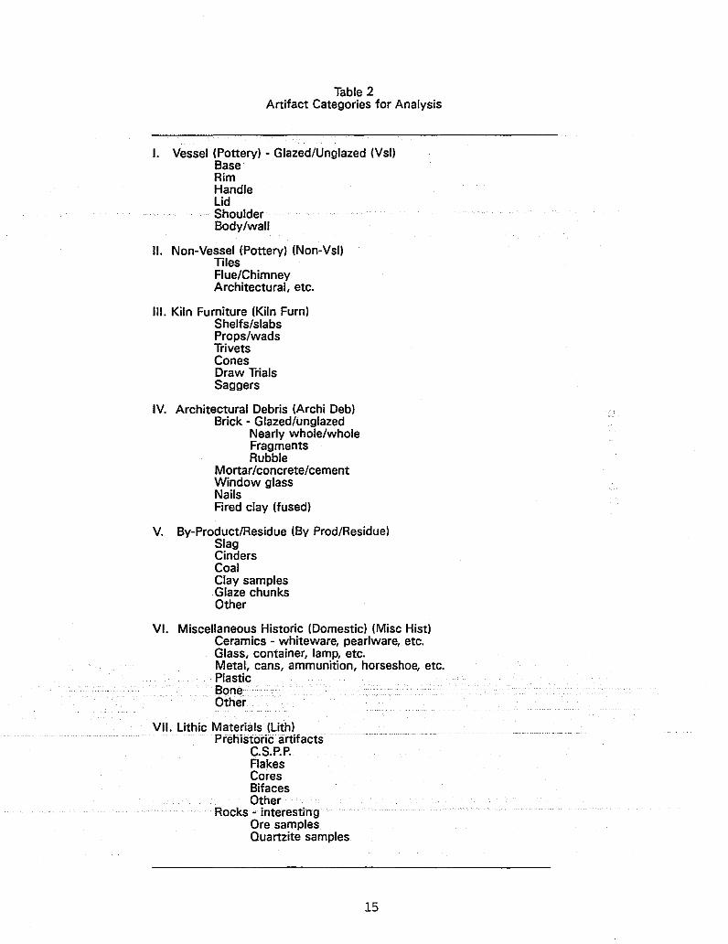
Table 2Artifact Categories for Analysis
I. Vessel (Pottery) - Glazed/Unglazed (Vsl)BaseRimHandlelidShoulderBody/wall
II. Non-Vessel (Pottery) (Non-Vsl)TilesFlue/ChimneyArchitectural, etc.
III. Kiln Furniture (Kiln Furn)Sheffs/slabsProps/wadsTrivetsConesDraw TriafsSaggers
IV. Architectural Debris (Archi Deb)Brick - Glazed/unglazed
Nearly whole/wholeFragmentsRubble
Mortar/concrete/cementWindow glassNailsFired clay (fused)
V. By-Product/Residue (By Prod/ResiduelSlagCindersCoalClay samplesGlaze chunksOther
VI. Miscellaneous Historic (Domestic) (Misc HistlCeramics - whiteware, pearlware, etc.Glass, container, lamp, etc.Metal, cans, ammunition, horseshoe, etc.PlasticBoneOther
VII. lithic Materials (lith)Prehistoric· artifacts
C.S.P.P.FlakesCoresBifacesOther
Rocks" interestingOre samplesQuartzite samples
15
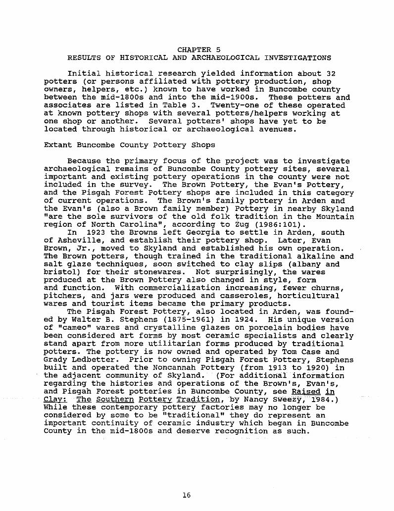
CHAPTER 5RESULTS OF HISTORICAL AND ARCHAEOLOGICAL INVESTIGATIONS
Initial historical research yielded information about 32potters (or persons affiliated with pottery production, shopowners, helpers, etc.) known to have worked in Buncombe countybetween the mid-1800s and into the mid-1900s. These potters andassociates are listed in Table 3. Twenty-one of these operatedat known pottery shops with several potters/helpers working atone shop or another. Several potters' shops have yet to belocated through historical or archaeological avenues.
Extant Buncombe County Pottery Shops
Because the primary focus of the project was to investigatearchaeological remains of Buncombe county pottery sites, severalimportant and existing pottery operations in the county were notincluded in the survey. The Brown Pottery, the Evan's Pottery,and the Pisgah Forest Pottery shops are included in this categoryof current operations. The Brown's family pottery in Arden andthe Evan's (also a Brown family member) Pottery in nearby Skyland"are the sole survivors of the old folk tradition in the Mountainregion of North Carolina", according to zug (1986:101).
In 1923 the Browns left Georgia to settle in Arden, southof Asheville, and establish their pottery shop. Later, EvanBrown, Jr., moved to Skyland and established his own operation.The Brown potters, though trained in the traditional alkaline andsalt glaze techniques, soon switched to clay slips (albany andbristol) for their stonewares. Not surprisingly, the waresproduced at the Brown Pottery also changed in style, formand function. with commercialization increasing, fewer churns,pitchers, and jars were produced and casseroles, horticulturalwares and tourist items became the primary products.
The Pisgah Forest Pottery, also located in Arden, was founded by Walter B. Stephens (1875-1961) in 1924. His unique versionof "cameo" wares and crystalline glazes on porcelain bodies havebeen considered art forms by most ceramic specialists and clearlystand apart from more utilitarian forms produced by traditionalpotters. The pottery is now owned and operated by Tom Case andGrady Ledbetter. Prior to owning Pisgah Forest pottery, Stephensbuilt and operated the Noncannah Pottery (from 1913 to 1920) inthe adjacent community of Skyland. (For additional informationregarding the histories and operations of the Brown's, Evan's,and Pisgah Forest potteries in Buncombe County, see Raised inClay: The Southern Pottery Tradition, by Nancy Sweezy, 1984.)While these contemporary pottery factories may no longer beconsidered by some to be "traditional" they do represent animportant continuity of ceramic industry which began in BuncombeCounty in the mid-1800s and deserve recognition as such.
16

Potter's Name
Bachelder, Oscar L.
Table 3Early Potters and Associates from Buncombe County
Census Records(1850-1880,
Birth/Death Potter/Associate Shop Affiliation 1900-1910)
1852-1935 Potter Rutherford, Bachelder Arrived 1911
Baird, Gilbert
Bassett, Jammie E.
Cheek, James R.
Cole,; T~K~·
Devlin, Francis
DeVlin, John
Conkel, David M.
Donkel, George B.
FUlbright, Alber~
Gorn, H. P.
GUdger, Robert
Lankford, Joseph
Lankford, Jeter
Mathews, Isaac
McClure, S. Wheaton
Penland, Casius W.
Penland, W. Marion
Penland, Joseph S.
Penland, John H.
Penland, C. J.
Presnell, Levi
Rhodes, William
Rutherford, James B.
ShUford, Mark
stone, Edward W.
stone, J. Henry
Throckmorton, Thomas
Potter
1849-? Potter
1858-1915 Associate/owner
1908~1984 Potter
c.1800-? Potter/helper
1855-? Helper
1866-1951 Potter
c.1864-1956 Potter
1867-? Potter
Potter
1868-? Associate
1847-? Potter
c.1880-? Potter
c.1806-? Potter
1866-1960 Potter/owner?
1892-1975 Potter
1868-1945 Potter
1845-? Potter
c.1825-? Potter
Potter?
c.1811-? Potter
c.1845-? Potter
1869-1953 Owner
c.1837-? Potter
c.1818-? Potter
1849-1911 Potter
Potter
George Donkel
Unknown
Cheek
George Ooilkel
Stone/Penland
Trull
MCClure/Yoder? ,Oonkel
McClure/Yoder? ,Oonkel
Bachelder/Throckmorton, TrUll, Penland, Rutherford andBrown
Unknown
Bachelder
Cheek, Lankford
Check, Lankford
stone/penland
McClure/Yoder
stone/Penland
stone/Penland. TrullRutherford
Stone/Penland
stone/Penland
stone/Penland
Stone/Penland?
stone/Penland
Rutherford
Unknown
stone/Penland
stone/Penland, CheekRutherford
Bachelder/Throckmorton
from Leftwich1989
1870
1860-1910
1910
1860"'"1870
1860-1880
1900-1910
1900-1910
1910
from Zug 1986
1880-1900
1900-1910
1910
1850
1870-1880
1900-1910
1870-1900
1870-1900
from Zug 1986
from Leftwich1989
from Zug 1986
1880-
1870-1910
1880-1900
1850-1880
arrived 1940
Trull, Benjamin R.
Trull, James O.
Trull, Wm. A
1838-1911 Potter
1884-1958 Potter
1874-? Helper
Stone/Penland, Trull 1880-1910
stone/Penland, Trull, 1900-1910Rutherford
1900-1910
Yoder, Levrick c~1829-? Potter/owner
17
McClure/Yoder 1900

Historical and Archaeological Investigations
The ten sites located during the course of this project wereclustered in two areas outside of Asheville, with five located inthe Candler community to the southwest, and five located in ornear Weaverville to the north. Table 4 lists the sites in orderof presentation, which will include a brief historical overviewof the two communities where the sites cluster, individual siteinformation (historical and archaeological), and their physicaldescriptions. A discussion of the artifacts recovered during theinvestigations follows.
Candler Area Settlement
The earliest settlement in the Candler area occurred alongthe drainage basin of Hominy Creek and its tributaries during thelate eighteenth century. An 1859 map of the county (by Colton)shows a stage coach line (road) extending from Asheville southwest to Waynesville. This route later became U.S. Highway 19-23.By 1903, railroads were added to this transportation corridor andHominy station was established. Cotton mills, brickyards,churches, and stores clustered along the main roads and waterways.
A northwest tributary of Hominy Creek, known as Webb Branch,forms the drainage in Big Cove. This cove was settled in theearly 1800s by the Webb, Rutherford, Taylor, Cathey, Hall andTrull families. James Rutherford received two land grants in thecove area in 1799 and 1808, each for 100 acres. A 2.4-mile looproad (called Big Cove Loop Road) now connects current residentsto the surrounding community. The Rutherford, Trull, and Fulbright pottery sites are located in the cove, and are accessiblefrom this hard surface road. The Stone/Penland site, also knownas Jugtown, is located along Justice Ridge Road, just east of theBig Cove settlement. The Bachelder site is located in the community of Luther, west of Candler, at the confluence of George'sBranch and Hominy Creek and adjacent to the railroad corridor.An early 1900s map shows homesteads of the curtis and Thompsonfamilies in the near vicinity and a store owned by James Buttrickon Luther Road.
The following descriptions include a brief history of eachpotter and pottery shop, site location, results of field investigations, and artifact summary for each site.
The Stone/Penland site (31Bn3871
Historical Investigations
The Stone/Penland Site, also known as Jugtown, was one ofthe oldest i·· continuously·· operated· pottery manufacturing sites .inBuncombe County investigated during this project. Census recordsindicate that members of the Penland family were early residentsof Buncombe County, arriving between 1807 and 1810.
The first Penland associated with pottery production in the
18
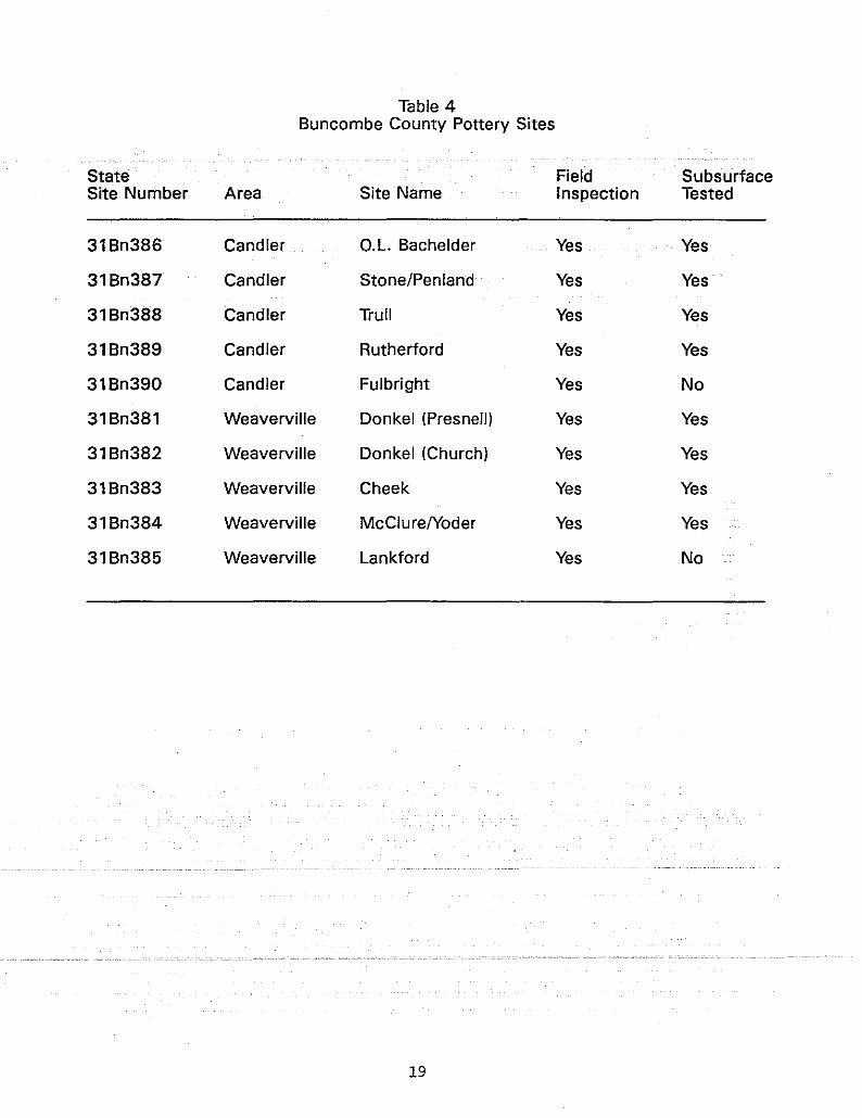
Table 4Buncombe County Pottery Sites
State Field SubsurfaceSite Number Area Site Name Inspection Tested
31Bn386 Candler c.L. Bachelder Yes Yes
31Bn387 Candler Stone/Penland Yes Yes
31Bn388 Candler Trull Yes Yes
31Bn389 Candler Rutherford Yes Yes
31Bn390 Candler Fulbright Yes No
31Bn381 Weaverville Donkel (Presnell) Yes Yes
31Bn382 Weaverville Donkel (Church) Yes Yes
31Bn383 Weaverville Cheek Yes Yes
31Bn384 Weaverville McClurelYoder Yes Yes
31Bn385 Weaverville Lankford Yes No
19
county was William Penland (born ca.1797), son of a John Penlandfrom Pennsylvania. John Penland was the son of another WilliamPenland, who moved from Pennsylvania to Rowan County, NorthCarolina, with his family in 1771. The second William Penlandappears on the 1840, 1850, and 1860 census listings, which indicates he was born in North Carolina. Land records show thatWilliam Penland bought 75 acres of property at the confluence ofPole Creek and Hominy Creek in 1830 (Deed Book 22:41). Familytradition and historical documents do not agree as to whetherWilliam Penland was a potter (Zug 1986:95-98). He was, however,influential in establishing this early pottery shop with the helpof Edward Whitfred stone, a skilled potter who immigrated fromSouth Carolina around 1844.
E.W. Stone was born ca.1818 in Virginia. He was believed tobe the son of an English potter from Blackpool (Leftwich: personal communication). stone left home at an early age and arrivedin the Edgefield District of South Carolina to further develophis pottery trade. Historical records suggest that stone learnedto make alkaline glazed stoneware from Thomas Chandler, an activepotter in the Edgefield District from 1838 to 1850. Chandlerdied in North Carolina in 1854, and may have had family connections in the state.
Although historical records do not indicate conclusivelythat William Penland's son, John H. (born 1825), was a potter,his son, Joseph Sylvester (William's grandson, born 1845), waslisted as a potter in the census documents. Charles Penland(born 1833), another of William's sons, also may have made somepottery as evidenced by several pieces stamped "C.J.PENLAND"(Leftwich: personal communication). In any event, Joseph S.Penland and James Henry Stone (born 1849), Edward's son, ran theJugtown Pottery Shop into the twentieth century.
J.H. stone was later hired by James Cheek to turn wares athis shop until it closed in 1912. Joseph's son, William MarionPenland (born 1868-died 1945) married Henry Stone's daughter,Emma, and maintained the pottery operation for four more decades.A daughter of Edward stone's named Sarah (born 1845) marriedanother potter from South Carolina named William Rhodes (born1845) .
Rhodes worked for many years at the Stone/Penland Jugtownpottery. Other potters from South Carolina's pottery districtwere attracted to the rich resources of the area and businessconnections available there. Isaac R. Matthews (born 1816), fromSouth Carolina, was listed as a laborer on the 1850 census, butwas probably a potter who worked at the Stone/Penland shop.Francis Devlin (born 1807) was another potter from south Carolina. He was listed on the 1860 census record as a neighbor ofJohn H. Penland. The 1900 census records also listed a WilliamStone (age 25) as a boarder living with Marion Penland and EmmaStone Penland. It is likely that he was a relative also employedas a potter or laborer at the Stone/Penland shop; FinallYiCasius ("Cash") Walter Penland (born 1892-died 1975), son ofMarion and Emma, continued to produce a limited line of potteryat the shop before giving it up to work at the Champion PaperCompany.
20

Interviews with Mrs. Kathleen Penland (age 89), Cash'swidow, and Doug Penland, one of their 12 children, provideduseful information regarding family and site histories. The oldhomeplace of Marion Penland stands on the east side of S.R.#1208.Emma stone Penland, widow of Marion, lived in the house until herdeath in 1965, at age 93. Cash and Kathleen lived in a smallhouse a few hundred feet east of Marion and Emma's house. Cashand Kathleen married in 1917 and built the small, one-room, dirtfloor house in 1920. There they raised a dozen children. Thepottery shop was located directly across the road, on the northside of S.R.#1208 and its intersection with S.R.#1214 (Figure 3).Kathleen recalled her mother-in-law, Emma stone Penland, sayingthat an earlier pottery shop had once been located on the southside of S.R.#1208, further east of the houses. All evidence ofit was gone by 1920, when she and Cash built their house.
According to one descendant, the homeplace tract consistedof 25 acres; Marion also owned 25 acres up in Big Cove. He wasknown to cut and haul wood from the cove tract to burn in hiskiln. Clay was either mined on the home tract or was hauled byoxcart from the bottomlands near Luther. Pottery production waspredominately a summer activity. Most wares were sold at thesite or taken to local hardware stores for sale. At times,Marion Penland had several hands working at the shop to filllarge orders. During the 1930 to 1950 production period, theirmain competitor was the Brown Pottery in Arden. Competition forfuel (wood resources) with local timber/lumber industries soonclosed the Penland Pottery shop.
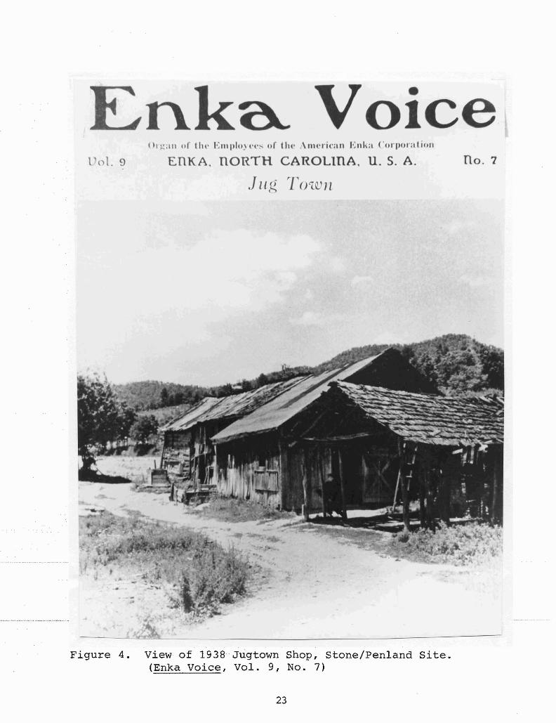
A photograph taken in 1938 and pUblished in the Enka Voiceshows the last shop at the site (Figure 4). An older log structure is seen in the back, with a well in front. A more recentwood frame shop is located in the foreground. It housed twogasoline-powered lathes (or wheels for turning) and one kickwheel. The edge of a shed which covered the groundhog kiln canbe seen in the right edge. The shop door faced the kiln fireboxend. The informant recalled that the kiln was loaded from thefirebox end, and unglazed pieces of ware were often stacked inthe low vaulted chamber. Children were recruited to help loadand unload the wares. A photograph, taken in 1938, shows WilliamMarion Penland at work in his shop (Figure 5).
Photographs were made of extant pottery pieces created bythe stones and Penlands, now in private collections. The earlierwares, all utilitarian forms, were glazed with alkaline glaze.This glaze was made from solutions of crushed glass or iron ore,or combination of both. Early wares were often marked by "E.STONE", "J,S, PENLAND"i"J,H,STONE"ior"W;M;PENLAND". Laterstonewares, made by W.M. Penland or his son, Cash, were albanyslipped and marked "PENLAND POTTERY, CANDLER, N.C.". In thelater years, some tablewares (glazed in either alkaline glaze or
slip) and unglazed horticultural wares were produced at
Archaeological Investigations
Archaeological investigations were conducted at the
21

Figure 3,
Stone/Penland Site(31Bn387)
~~"'~\"-~~,-,
creek
oTU2
OTU3
oTU1
rmetal pole
~
! / // /
! + Map Base Ai-
OTU4 \
1-
\1-
\
.'
/ IMap Base B'::+~=~d~rfilv~eW~a~Y-c.=
C',l~'l J\ \, .;;,
\V\
1feet
o 20
NN
a Voicel 01. 9
()1.~:11l of tht' EI1II)lo~t'I'" of th(' o\nu.'ri(Oan Enl a Corporation
EnKA, nORTH CAROLInA, U. S. A.
.J II (~ rrO'lQ) 1l
no. 7
Figure 4. View of 1938 Jugtown Shop, stone/Penland Site.(Enka Voice, Vol. 9, No.7)
23

Jug Town's Mr. Penland
Figure 5. View of Marion Penland at work in 1938.(Enka Voice, Vol. 9, No.7)
24

stone/Penland site between May 21 and May 23, 1989. The firstarea targeted for testing was a grassy, vacant lot south ofS.R.#1208 and east of a small unnamed stream. Information fromtwo sources suggested this old garden plot was the earlierkiln/shop location referred to by Emma Penland. A surface collection along the north roadway embankment yielded numerouspottery fragments and glazed brick rubble. According to thecurrent landowner, Doug Penland, considerable alterations hadoccurred to the roadway, driveways, and front yard areas of theold homeplace.
The low garden spot appeared to be the least disturbed.Four 2x2-foot test units were laid out 15 feet apart in a northalignment across the garden area (Figure 3). Artifacts were few(n=20), but compact clay fill was extensive. A line of singlelaid bricks (oriented northeast to southwest) was exposed in Testunit 1, adjacent to recent fill (containing plastic, electricalwire, and aluminum foil). It was later learned that this featureserved as a platform for a house trailer which had been recentlyremoved. No structural remnants or sherd concentrations relatedto pottery manufacturing were observed during these excavations.A decision was made to test across the road where the later(last) kiln and shop were known to have been located.
The site is located in the northwest quadrant of propertywhere S.R.#1214 intersects S.R.#1208. A small unnamed branch(possibly springfed) parallels S.R.#1208 on the north. As shownin Figure 3, a house, driveway, and fenced lawn now occupy thecenter of the site. According to Kathleen Penland, the house anddriveway are situated exactly where the old shop and kiln wereonce located (as seen in the 1938 photo).
Confronted with this data, plans were made to investigatethe old garden area situated between the fenced lawn and thecreek. This was done to determine the subsurface integrity forthe remainder of the site and location of possible waster piles.Permission was obtained from the current owner, Henry Wallace,and a pedestrian survey was conducted. A total of 330 artifacts,mostly pottery fragments, were found on the surface. This finding suggested debris from the pottery shop activities had beenscattered north and downhill towards the creek. Ten 2x2-foottest units were laid out across the garden, in two rows approximately 10, 15, or 20 feet apart (see Figure 3). A datum wasestablished at a concrete marker adjacent to S.R.#1214. Eight ofthe 10 units were excavated and north profiles drawn (Figure 6).Depths of units ranged from 1.1 to 2.3 feet below ground surface.stratigraphy in the units revealed two episodes of fill depositedon the siteiprobably coincident with house construction andalandscaping. Glazed brick fragments, kiln furniture, and numerous stoneware sherds were recovered from the test units andsurface collections, but no intact structural remains were exposed.
Artifact Summary
A summary of artifacts recovered from 12 test unit excavations and surface collections at the stone/Penland site is pro-
25

Stone/Penland Site(31Bn387)
North Profiles
p,
light brown
I (tl• od F:i:!::~~====:!:=~g;:f:1
P'light brown
,rdark gray. h lena
orange micaceoull clay
TU1 <::J .e-.d' <1' <:? C1orange '\ -, e-
m '~~p'....u~• ."J.~~.~'.•~~...~. clay /" ro 0
e::>
TU7
I,ll {\U I{ If \/1111 1.od
TU8
\ ) ( I A"/(1 I) ", /UA,)I)
p,
light brown
I---
moltled orange clay
subsoil
.od
TU3
8011
p,
light brown
brown
loose
mottled orange CI8Y~,,,rA!iW,',
p,
light brown
I-------~TU4orange micaceous clay
p,
light brown
p,light brown
mottled clay
orange micaceoull clay
Om.t.' <:::::;::>~
TU5
1mottled ofange clay TU9
aahy gray lene
N orange clay
foot
0 1
Figure 6. Profile drawings of selected test units.
26

vided in Table 5. A total of 737 items was found. Vessel fragments comprised the most frequent artifact class (60%, n=441) ofthe total assemblage, followed by Architectural Debris (15%) andMiscellaneous Historic categories (13%). All other categoriescomprised less than 10% each. The majority of vessel fragmentswere alkaline glazed stoneware; a few had rutile (titanium dioxide), and one rim sherd appeared to have cobalt accent color.One body sherd (from surface collection) was incised with a "6"as a capacity indicator. A single sherd from Test unit 4 hadbeen stamped with a "W", possibly for W.M. Penland maker. Fortythree pieces of kiln furniture were found at the site. Most ofthese were shelf/slab fragments used to stack the wares in thekiln. Test unit 2 contained the greatest quantity of artifactsfrom excavated context with 92 pieces.
Vessel form analysis, based on 44 recognizable rim sherds,showed crocks (n=8) were again the most prevalent form, followedby jars (n=7), churns (n=5), unglazed flowerpots (n=4), canisterforms (n=4), pitchers (n=3), and one each of cup, plate, and unidentifiable form. The canister may represent a cylindrical crockform.
The Trull site (31Bn3881
Historical Investigations
Benjamin Robert Trull (born 1838 in North Carolina), firstappeared on the Buncombe County census records in 1880. According to Opal Barnes, B.R. Trull's granddaughter, the first Trullin the Big Cove community was her great-grandfather, ReverendJohn G. Trull. Around 1870, John Trull deeded land to the Northern Methodist congregation to build a small church in Big Cove,near Webb's Branch. A stipulation required that if the churchceased to exist, the property would revert to the Trull familyheirs. Indeed the church closed and the building was dismantled,leaving only a fenced-in cemetery atop the hill. Lumber from thebuilding was used to build a homeplace down the hill for BenTrull and his wife, Violet. There they raised nine children.The Trull family cemetery is still located on the hilltop nearOpal Barnes' property and the old Trull homeplace.
Benjamin Trull's farm was located on the east side of BigCove, along S.R.#1207 (Big cove LoOp Road). His main occupationwas farming, but he apparently picked up the pottery trade alongthe way, probably through connections with the nearby Penlands.During the late 1890s,·BenTrullbuilt his own pottery shopandwas assisted by his two sons, William (born 1874) and James otis(born 1884). William (or Bill), Trull lived next door to thePenland pottery shop and probably worked there as well. A 1903Buncombe County map shows Bill Trull's house on the south side ofJustice Ridge Road (now·partofS.R,#1208), ····opposite·· .IIJugFactory" (a.k.a. Jugtown, the Penland Pottery). Unfortunately, nofamilies or homesteads are shown on Big Cove Road on this map.
James (or Jim) otis Trull, went to work at his father'sshop, along with Albert FUlbright, a potter from South Carolina,
27
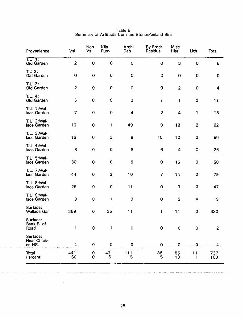
Table 5Summary of Artifacts from the Stone/Penland Site
Non- Kiln Archi By Prod/ MiseProvenience Vsl Vsl Fum Deb Residue Hist Lith Total
T.U.l:Old Garden 2 0 0 0 0 3 0 5
T.U 2:Old Garden 0 0 0 0 0 0 0 0
T.U.3:Old Garden 2 0 0 0 0 2 0 4
T.U.4:Old Garden 5 0 0 2 1 1 2 11
T.U.l:Wal-lace Garden 7 0 0 4 2 4 18
T.U.2:Wal-lace Garden 12 0 49 9 19 2 92
T.U.3:Wal-lace Garden 19 0 3 8 10 10 0 50
T.U.4:Wal-lace Garden 8 0 0 8 6 4 0 26
T.U.5:Wal-lace Garden 30 0 0 5 0 15 0 50
T.U.7:Wal-lace Garden 44 0 2 10 7 14 2 79
T.U. 8:Wal-lace Garden 29 0 0 11 0 7 0 47
T.U.9:Wal-lace Garden 9 0 3 0 2 4 19
Surface:Wallace Gar 269 0 35 11 1 14 0 330
Surface:Bank S. ofRoad 1 0 1 0 0 0 0 2
Surface:Near Chick-en HS. 4 0 0 0 0 0 0 4
Total 441 0 43 111 36 95 11 737Percent 60 0 6 15 5 13 1 100
28
who settled in the cove area. A land deed dated 1904 (Deed Book142:5), indicated B.R. Trull sold 17 acres of property to AlbertFUlbright. In 1910, B.R. Trull also sold 20 acres to his sonJames (Deed Book 171:434). Benjamin Trull died in 1911 at. theage of 73. Jim Trull married Clyda Rutherford (born 1894), thedaughter of another Big Cove resident and pottery shop owner,James D. Rutherford. Trull continued to make pottery at othershops, however, namely the Rutherford, penland, and Pisgah Forestoperations.
Jim and Clyda had six children, and in 1958, when Jim died,the land holdings were divided among thesurvivirig five children.Opal Barnes, Jim's daughter, acquired the "shop lot" at thattime, and has maintained its ownership. Opal, who was born in1912, has no recollection of the shop or kiln. According to hermother, Clyda, now 95, the shop closed before Opal was born.Opal and her husband moved to the property and built a house in1963. Her sister, Margaret, who married the twin brother ofOpal's husband, lives next door, and the two families maintainthe hometract. During the last several decades, the field wherethe shop stood has been used for agricultural purposes.
A few intact pieces of pottery made by the Trulls wereexamined and photographed during this investigation. All pieceswere stoneware and glazed with either alkaline glaze or albanyslip. The albany slip pieces may have been made by Jim Trull atthe Rutherford or Penland pottery shops. One monkey jug withalbany slip is marked "PRESENTED BY J.O.TRULL SEPT. 15, 1911" - atime when the potter worked at the Rutherford pottery (Figure 7).
Archaeological Investigations
The Trull pottery site is located in an open field on theeast side of S.R.#1207 and west of Webb's Branch which parallelsthe road. The site is bordered on the south by the Reagan'sdriveway and on the north by Opal Barnes' driveway. The site wasaltered when the state road was realigned and elevated. Fieldwork began On May 26 a.nd el1ded 011J\ll1e3, 1989. Ground surfacevisibility was minimal because the field was covered in tallgrasses and hay. Therefore, a modified field strategy was employed. A steel probe was used to isolate spots across the sitefor subsurface testing. Walking transects east to west acrossthe site at 15-foot intervals, flags were placed in probe holeswhere resistance.was.encountered.
Thirty-eight shovel tests (approximately1x1-footj wereexcavated to varying depths, depending. on the level of bedrockandjorsterile·subsoil; Average depth for all shovel tests was1. 9 feet. Shovel Test 35 was the deepest at 3.4 feet, and threeshovel tests were less than a foot where bedrock was shallow.Shovel tests which contained more than five potsherds are circledon Figure 8, noting a concentration of pottery in the centerportionof···the···field·. Onlytwo···gl:azed(kil:n)brick·····fragmentswere found, one each in shovel tests 7 and 12. Excavation ofShovel Test 15 exposed a lens of dark gray, micaceous, silty soilfrom 1.4 to 1.8 feet below ground surface. Initially, thisdiscoloration was thought to be a cUltural feature associated
29

Figure 7. View of Trull monkey jug dated 1911.
30

Trull Site(31 Bn388)
, ,
N140
feet
o
house
Opal's
.cuc..~
m
• ST3a
<ilST35
Map Baas A+--'
(JST3
(JST17
ST34·
<ilST2
STU@
ST12ST13<!l (J @STll
STSO'
STU·
property marker
STP 8T31·
ST21 +~ole
.ST22 STla'.ST23SUO
• ·ST19
ST 18 ST8<i (J
STe (J (JST10
ST25@ TU 1ST24GlQI'iJ GlST28
ST38(J ST1{GlST28GlSU7
G> G> @SHST28Gl ST7 ST5
-c..E"'"c.....E..
~ ~;;~~=-==-==--==-~o -t'-/'-------r---,0:
C>oo......>oo~m
toC\I
Figure 8. Location map of shovel tests excavated at the site.31

with previous pottery activities at the site. A 5x5-foot unit(Test unit 1) was then laid out and excavated adjacent to ShovelTest 15. Level I (from .2 to 1.4 feet deep) was a mixed brownloam (old plowzone) containing pottery fragments, kiln furniture,glazed brick fragments, nails and some charcoal. Level II (from1.4 to 1.8 feet deep) was the gray, silty lens which contained noartifacts, but extended across the entire 5x5-foot unit. Deeperexcavation continued in the northeast corner of the unit(2.5x2.5-foot section), to a depth of 3.3 feet. Below the graylens was an orange, silty lens containing medium-sized rivercobbles and gravel, and no artifacts.
Additional shovel tests were dug in four directions extending out from this unit to determine the horizontal and verticalextent of this gray, silty lens. The shovel test results indicated a linear deposit of gray, silty soil (below plowzone)oriented north-south, 35 to 40 feet in length, and east-west, 15to 20 feet wide. still no artifacts or cultural features wereassociated with this soil lens, suggesting a natural origin,(perhaps as a pond or remnant slough).
Before concluding field investigations a few shovel testswere excavated in areas where probing indicated no subsurfaceobstacles. None were encountered during testing but stratigraphic information was recorded. Finally, all units were plotted inusing a transit and an overall site map constructed.
Artifact Summary
Artifacts recovered from test excavations at the Trull siteare provided in summary on Table 6. A total of 874 artifactscame from 38 shovel tests, one 5x5-foot unit, and a surfacecollection donated by the property owner. The surface collectedartifacts, comprised of pottery and kiln furniture fragments,were picked up by the owner during the previous years' plowing.Large sherds came from the creek bank. They had been intentionally deposited there during clearance of the field for cultivation.Nearly half the total assemblage (44.9%) of artifacts from thesite came from Test unit 1 excavations. Shovel tests 15, 24, and28 had over 30 artifacts each.
Vessel fragments, of alkaline glazed and albany slippedstonewares, comprised 73% (n=641) of the artifacts recovered. Nomarked sherds were found. Architectural Debris (mostly nails,and few brick fragments) made up 10% (n=85), while Kiln Furniturewas 7% (n=60) of the total. Shelf/slab pieces were the mostfrequent kiln furniture, with a few fired clay wads/props. Onepolished greenstone atlatl weight fragment, of aboriginal manu~
facture, was found in Shovel Test 20. This artifact probablydates to the Middle to Late Archaic cultural period.
Analysis of 50 rim fragments revealed crock forms to be themost prevalent (n=28), followed by unglazed flowerpots (n=11).Other forms represented were jars (n=3) ,jugs (n=3),pitcher(n=1), bowl (n=1), and two utilitarian dishes (waterers?). Oneunidentifiable form was found.
32

Table 6Summary of Artifacts from the Trull Site
Non" Kiln Archi By Prod! MiscProvenience Vsl Vsl Fum Deb Residue Hist Lith Total
S.T. 1 1 0 0 0 0 0 0 1S.T.2 5 0 0 1 0 0 1 7S.T.3 7 0 0 1 0 0 0 8S.T.4 7 0 0 1 1 0 0 9S.T.5 7 0 0 0 0 0 0 7S.T.6 0 0 0 0 0 0 0 0S.T.7 12 0 0 1 0 1 0 14S.T.8 2 0 0 0 0 0 0 2S.T.9 9 0 0 6 2 2 0 19S.T.10 8 0 3 2 1 1 3 18S.T.11 9 0 0 10 5 0 0 24S.T.12 4 0 0 9 0 0 0 13S.T.13 5 0 0 4 0 1 0 10S.T.14 7 0 0 3 0 0 0 10S.T.15 24 0 1 0 1 0 5 31S.T.16 5 0 0 3 0 2 1 11S.T.17 6 0 2 2 2 0 1 13S.T.18 0 0 0 3 0 1 0 4S.T.19 0 0 2 1 0 0 1 4S.T.20 1 0 0 0 0 0 1 2S.T.21 3 0 0 0 0 1 0 4S.T.22 0 0 0 0 0 0 0 0S.T.23 8 0 0 0 0 0 0 8S.T.24 34 0 2 3 1 2 1 43S.T.25 8 0 1 1 1 0 0 11S.T.26 12 0 0 0 0 0 0 12S.T.27 15 0 5 2 0 1 0 23S.T.28 25 0 1 4 0 8 0 38S.T.29 9 0 1 3 0 1 0 14S.T.30 1 0 0 1 0 0 0 2S.T.31 5 0 0 0 0 0 0 5S.T.32 0 0 0 0 1 0 0 1S.T.33 0 0 0 0 0 0 0 0S.T.34 2 0 0 0 0 1 3 6S.T.35 5 0 0 0 0 0 4 9S.T.36 8 0 0 1 0 1 0 10S.T.37 3 0 0 0 0 0 0 3S.T.38 2 0 ·0 2 0 1 O· 5T.U.1 319 0 25 21 91 17 2 393Surface 63 0 17 0 0 0 0 80
Total 641 0 60 85 24 41 23 874
S.T. - Shovel Test
33
The Rutherford site (31Bn3891
Historical Investigations
Buncombe County census records indicate that James D. Rutherford's grandfather, James J. Rutherford (born ca. 1800), andhis wife Barbara were county residents by the 1850s. They had ason, also named James, (born ca. 1820) who was listed on the 1860census records with his wife Sarah. It is unclear as to whetherthis James Rutherford was James D.'s father or uncle because by1870, Barbara Rutherford (James J.'s widow) has a one-year oldJames Rutherford listed in her household. Neither Sarah or Jamesare listed with the child, if they were his parents. By 1880Sarah and James Rutherford appeared again, along with five children, and no James, who would have been 11. Thirty years later,James D. Rutherford, age 41, was listed as a farmer, along withhis wife Cora Cole (born 1870), and six children. Thomas Rutherford, the fifth child (born 1906) is the current property owner.James D. Rutherford died in 1953. The old Rutherford homeplacestill stands on the property.
James Devrick Rutherford (born 1869) was not a potter butbuilt a pottery shop on the southern end of his farm located onthe west side of Big Cove. Rutherford provided the capital andthe facility and hired local craftsmen to turn the wares; amongwhom were Oscar Lewis Bachelder, Albert Fulbright, James HenryStone, Robert Anderson, William Marion penland, and James otisTrull (his son-in-law).
The shop was built around 1907 and ceased operation in 1914(Tom Rutherford: personal communication). The pottery was located in a small valley on the north side of a creek which feedsinto Webb's Branch. The wooden-frame shop was equipped with a20-foot water wheel to power the equipment. A long wooden racechanneled the water towards the power wheel. Clay was hauled infrom the rich claybeds located in Luther and/or Hendersonville.
A few existing pottery pieces known to have been manufactured at this site were available for examination. According tolocal collectors, most of the wares were albany slipped. A lineof mold-made items also were manufactured at the Rutherford Pottery, in addition to the traditional wheel-turned utilitarianvessels. The shop operated at factory-level production; largeorders were received, filled and then shipped out. Earlierstonewares produced were alkaline glazed consisting of a mixtureof crushed glass and iron ore which produced a mottled orangebrown to black color (Zug 1986:98).
Archaeological Investigations
The Rutherford site is located on the west side of S.R.#1207and north of a small tributary of Webb's Branch. Because offield· crops which· needed to be· harvested,· it site was the·· lastpottery location to be archaeologically investigated during thisproject. Field work began on July 18 and ended July 22, 1990.An on-site interview with Tom Rutherford, current owner anddescendant of James D. Rutherford, provided significant informa-
34
tion in pinpointing the shop and kiln locations in a field adjacent to the relict homeplace.
Tom remembered the shop as a wooden frame structure set upon log sills which had a drying shed attached to one end. Afterthe pottery shop closed, the shed was converted to an animalshelter. He recalled the kiln as a long, rectangular brickstructure situated on the hillside. It was oriented north tosouth. He had helped to dismantle it several years ago when thefield. was being prepared for cultivation. An old roadway whichconnected the house to the road passed between the shop and thekiln. Figure 9 illustrates the site with appurtenances andarchaeological test units.
A series of probe test were placed along the hillside southeast of the old house. Subsequent shovel tests revealed theremains of a brick structure. Five shovel tests were expandedinto 2x2, 2x4, or 2x6-foot units to expose three sides (or walls)of a rectangularly-shaped brick kiln. Test unit 10 was expandedto expose the chimney base of the structure. This end was thebest preserved and was 10 brick courses in height (2.1 feet).Width of the chimney end was 1.8 feet. A builder's trench wasdiscovered on the outside edge of the wall in test units 9 and10. Shovel Test 6 was expanded into Test unit 6, a 2x2-footsquare, which revealed an intact portion of the south (side)! wallof the kiln. Wall width on the side was 1.35 feet. Test unit 8was was placed of the opposite side wall (north). This side ofthe kiln had been disturbed but its alignment was determined fromsoil discoloration and hardness. Two inner brick supports werealso exposed in Test unit 10. These arch supports measured twofeet square, and were spaced .8 feet apart across the width bfthe vault (or kiln interior).
Interior width of the kiln was 12 feet and overall width was15 feet (two side walls of 1.5 feet each). Length was estimatedto be between 21 and 23 feet. Exact length of the kiln was moredifficult to determine due to disturbances at the firebox end.
Abundant waster materials, pottery, kiln furniture and brickrubble were recovered from shovel test and unit excavations.Test Unit 11, at the firebox end, yielded 285 (34% of the totalassemblage). This noted concentration and the narrow width between arch supports at the chimney end, suggest that the kiln wasprobably loaded through the downhill or firebox end.
Detailed plan and profile drawings were made of test units6, 8, 9, 10, and 11 (Figure 10). No shovel tests were dug in theshop vicinity. Given the shop's shallow foundation (on logsills) and the known extent of cultivation in the bottom portionof the field, ··it· seemed· unlikely that .subsurface remains· existed;All units were mapped plotted in and an overall site plan constructed (Figure 9).
Artifact Summary
Table 7 provides a summary of artifacts from the Rutherfordsite. No surface collection was possible due to thick vegetationcover. Of the 839 total artifacts from the excavations, VesselFragments and Architectural Debris comprised the two most fre-
35

,,,.-
\ \
\ \
\ \ ST2 TUB - -",• L,\;>:: ' " .,. ST7\ \ --:- i$(TU10\o~ TU1 <..-- ",~~~-'#:.rU9
~ '0\ ST3 ;0 .. _> TU.6
~~~ \ ,kiln '::;J ST5
~,Figure 9. Areal view of site and kiln location.
fenced pasture
,,,,, . ,/,/
,/,/
('"..~~o \
+
\+\
dead tre~ \'-" +
'" \
\\
field
1N
20
feet
o
Rutherford Site(318n389)
Map Base A")
+w I
'" II I
,
I I, ,I ''e-
,0
I I ,~
I I ·sn\ \

Rutherford Site (318n389)Plans and Profiles
Easl PrOfile'I,ll\' )l'~iI'\)!~\\I\ \,;
brick rUbble .~".~' .:' • .. •• sod. . .. . '. , ..brown-orange ~.-
-TU9 - alily
tan-brown silty
t disturbed J
Ian
tan sUty":'-1<il;,'w~1I'/j
deep,loose fill( ,--,......., )
..-J JA I
light brownBandy soli
builder's trench
:t. chimney end--1
\!~.
gray-greengravel floor
:arch supports\
heavy glazedeposit
-TU11- .'
L kiln wall--"corner?
foot
aod
North Profile,II" )I ",( ,\ \ ,\
8n siltysubsoil
Ixed brown-orang
«-TU6- .fe-d- crumbiy- i~· ~;.
floor
o 1 firebox end?
Kiln remnants exposed in five test units at the site.
t..klln wall J
glaze deposit
I:- I I .
l-
I
·H\ I
fJ.....
Figure 10.
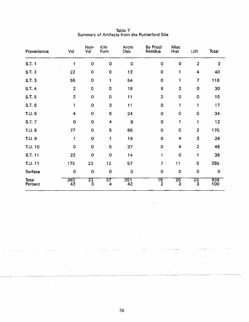
Table 7Summary of Artifacts from the Rutherford Site
Non- Kiln Archi By Prod/ MiscProvenience Vsl Vsl Fum Deb Residue Hist Lith Total
S.T.1 1 0 0 0 0 0 2 3
S.T.2 22 0 0 13 0 1 4 40
S.T.3 55 0 1 54 0 1 7 118
S.T.4 2 0 0 19 6 3 0 30
S.T.5 2 0 0 11 2 0 0 15
S.T.6 1 0 3 11 0 1 1 17
T.U.6 4 0 6 24 0 0 0 34
S.T.7 0 0 4 6 0 1 1 12
T.U.8 77 0 5 86 0 0 2 170
T.U.9 1 0 1 19 0 4 3 28
T.U.l0 0 0 5 37 0 4 2 48
S.T.ll 23 0 0 14 0 1 39
T.U.ll 175 23 12 57 7 11 0 285
Surface 0 0 0 0 0 0 0 0
Total 363 23 37 351 16 26 23 839Percent 43 3 4 42 2 3 3 100
38

quent categories, with 43% (n=363) and 42% (n=351), respectively.Bricks, glazed and unglazed, were the most abundant architecturalelement. Thirty-seven pieces of kiln furniture (4%) were found.These were flattened shelf/slab fragments. One nearly whole,glazed draw trial (or tester) was found in Shovel Test 7 (Figure11). Twenty-three ceramic items, tentatively identified as Nonvessel, were found in Test unit 11 (Figure 12). The function ofthese unglazed ceramic objects has yet to be determined. It isreasonable to assume that these items may have served a nonlocal, non-domestic function since the Rutherford factory supplied goods to distant commercial enterprises as well as localconsumers.
Of the 363 pottery fragments, only 46 rim sherds were recovered for vessel form analysis. All vessel form rims were albanyslipped. Three body sherds were slipped with a whitish, opaqueglaze similar to a bristol glaze; two were accented with cobalt.Vessel forms represented were crocks (n=15), jars (n=3), unglazedflowerpots (n=93), a churn, and a bowl.
THE BACHELDER SITE (31Bn3861
Historical Investigations
Oscar Lewis Bachelder was born in Menasha, Wisconsin, onJuly 14, 1852. He was a third generation potter, the son ofCalvin B. Bachelder (1826-1906), and grandson of Luther ClevelandBachelder (1804-1850). L.C. Bachelder produced earthenwares inMaine from ca. 1830 until 1845, and later moved his family toWisconsin. Following the death of his father (L.C.B.) in 1850,Calvin Bachelder and brother, Carlton set up a pottery factory inMenasha, Wisconsin which operated until 1860. Calvin then movedhis family to Ohio and later to Pennsylvania, then to Illinoisand finally to Nebraska. Carlton continued his own potterybusiness in manufacturing and wholesaling of earthenware andlater stonewares in Menasha until around 1895.
Oscar received his early training in the pottery shop of hisfather, whom he described as a "stern master." Oscar left homeat an early age and traveled around 28 states over a 40 yearperiod practicing as an itinerant potter. He took pride in hisability to produce large pieces of pottery in great quantities.At 60 years old, tired of traveling; he became attracted to therich clay deposits of western North Carolina and, through contacts with James Rutherford, he moved into Buncombe County. In1911, he arrived towork·forRutherford'spottery·factory, withthe local potters, Trull, Penland, and Fulbright. He remainedthere until it ceased operation in 1914.
By that time, he had made arrangements with Robert Gudger tobUy on credit four acres of land from Gudger's aunt (TelithaMorgan)·····near·· Luther. ·There·heand····Gudger,·····in··partnership,set ·upa pottery shOp in 1916 (Figure 13). Bachelder named the potteryafter an admired literary character, Omar Khayyam. In the beginning Bachelder produced utilitarian forms which were made toserve the local, rural community. Gudger became the distributor,
39
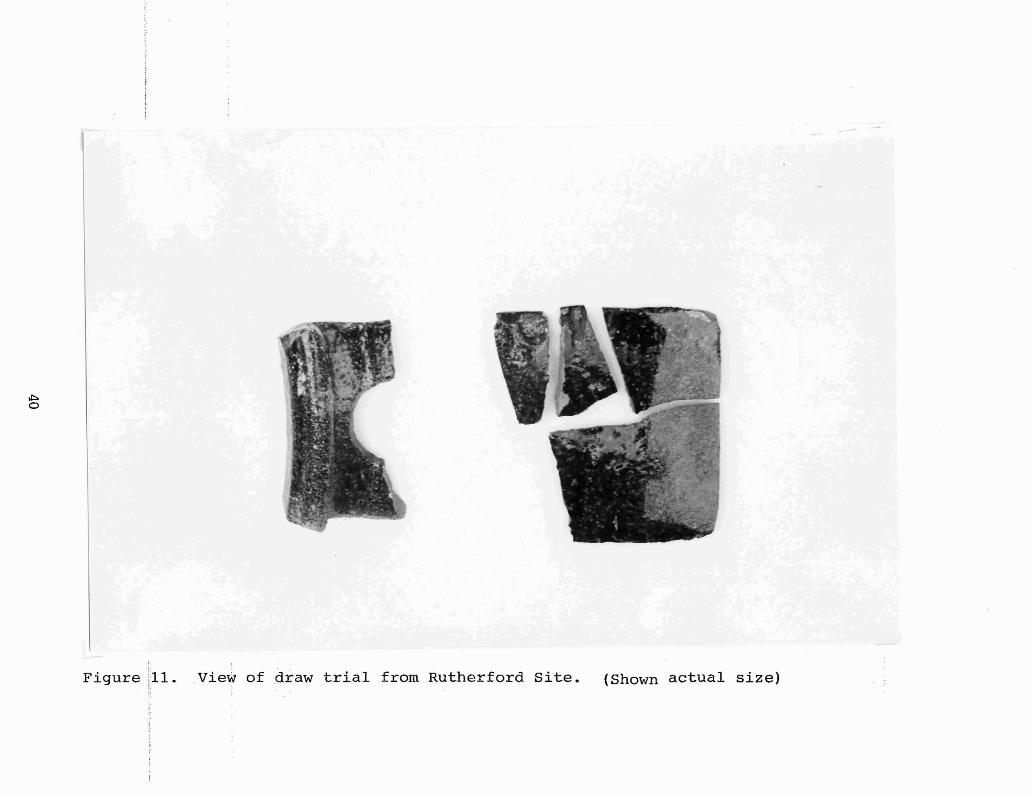
Figure ill. View of draw trial from Rutherford Site. (Shown actual size)

Figure 12. View of non-vessel forms from Rutherford Site.

Fig~re 13. Early view of Bachelder Pottery Site. (Johnston and Bridges 1983)
and hauled the wares by wagon load to Asheville, Black Mountain,Old Fort, Marion, and Hickory.
Descriptions of the shop in later years, indicate that therewere two kilns on the site, one a round downdraft type and theother a rectangular groundhog style (Johnston 1983:24). Therewere also two lathes or kickwheels used to turn the wares. Allclays were dug locally, in the creek bottom adjacent to the site.Later, clays were hauled in or ordered from out of state and usedto blend with local deposits. This practice was not necessaryuntil Bachelder increased his production of art forms with aporcelaneous body.
Oscar married Agnes Collins in 1917. She later picked upthe trade and helped her husband in the shop. She marked herwares with "AB". Gudger retired his half of the partnership toraise his family, but continued to take an active interest in hisneighbor's pottery business.
Oscar then began concentrating on the production of artforms and tablewares. His glazes ranged in color from maroons toblacks to browns to whites, occasionally sprinkled with ashes,cobalt or manganese for decorative effect. His art potteryreceived national attention and in 1919 he was awarded a medalfor the Applied Arts Exhibition in Chicago.
He had many helpers and potters who worked with him over theyears, including Ray Welch, Eugene Mintz, Ned Williams, andMorris GUdger of Buncombe County as helpers; and Paul st. Gaudensof New Hampshire, Walter Stephens from Pisgah Forest Pottery;William Soini of Finland, and Converse Harwell of Alabama aspotters. (For a detailed account of Oscar Lewis Bachelder and thehistory of the Omar Khayyam Pottery see~ Bachelder and HisOmar Khayyam Pottery, by Pat H. Johnson and Daisy W. Bridges,1983).
Oscar died in 1935 and in 1937, his widow, Agnes, sold theshop and kilns to Christine Gudger Bates and her husband. Asmall unglazed pitcher, from the current property owners' collection, is marked on the base "C. Bates, Aug. 1938, Omar KhayyamWare". This finding suggests that Bates produced some pottery atthe site and continued to use the Omar Khayyam name for herwares.
Agnes died in 1938, and shortly afterwards in 1940, Batessold the land and shop to Thomas Throckmorton. Throckmorton wasan artist/sculptor from Mississippi who had been working for theShearwater pottery. He and his wife produced art pottery andsome tablewares. One informant, who as a young girl cared forthe Throckmorton children, recalled that Throckmorton producedonly mold-made pieces·· and· hired Albert Fulbright; a local potter ,assisted in decorating and signing the finished pieces. Mostwares were made on consignment or were hauled into Asheville andsold at craft shops.
The informant also recalled only one kiln present at thattime.·· The· kiln was circular,····l0··to··12···feet in·· diameterj-andbottle-shaped with perimeter fireboxes at its baSe. The kiln wasenclosed in one end of the wooden frame shop and living quarterswere attached to the other end. Wood continued to be used as theprimary fuel source.
43

Ray Penland and Roy stamey also assisted Throckmorton in theproduction of molded wares. It is not clear how long Throckmorton operated the pottery shop, but with the outbreak of WWII anda depressed economy, he soon returned north to reside. He maintained ownership, however, until 1970.
The property, with its abandoned structures, was then soldto the current owners. According to them, the shop and kilnremains were still standing until 1972. The relict structureswere then dismantled and burned off in preparation for a newhouse, completed in 1974. Subsequent landscaping activities inand around the house foundation and along the creek bank probablyreduced any undisturbed deposits. Visible waster piles or structural remains were landscaped and planted over.
Archaeological Investigations
The Bachelder site is located on the south side of oldWaynesville/Asheville Highway (now S.R.#1130), and east ofGeorge's Branch and its confluence with Hominy Creek. As shownin Figure 14, the center of the site is now occupied by a brickhouse. Therefore, archaeological test units (2X2-foot square)were laid out and excavated south and west of this extant structure. These areas appeared to be the least disturbed by modernlandscaping and were perhaps all that remained of the originalground surface. The front yard had been filled in during houseconstruction.
Surface collections were made along the east bank ofGeorge's Branch, where informants had noticed brick and ceramicwaster debris, and in the plowed garden (approximately two acres)located southeast of the house. The remainder of the site wascovered in lawn and/or trees and shrubs. Map Base A served aspermanent datum. Test units 1 through 4 were situated 20 feetapart in an east/west line, 15 feet south of the house. Testunits 5 and 6, also 20 feet apart, were 65 feet south of thehouse on an east/west line. Test units 7 and 8 were placed neara four-foot embankment which paralleled the creek south of theroadway. Test unit 9, expanded into a 2x4-foot trench, wasplaced perpendicular along this embankment. North profiles fortest units 1 through 7 revealed mUltiple stratigraphic levels 1.2to 1.7 feet below ground surface. A layer of mixed brown loamwith brick flecks was noted below sod. sterile subsoil consistedof micaceous orange or olive clay. Figure 15 summarizes thisinformation. Test unit 8, not drawn, contained solid fill ofmixed clays, probably a result of front yard and roadway alterations. Test unit 9, cut into the embankment, contained abundantarchitectural debris and pottery wasters which had been piledalong this slope to retard erosion. No distinct stratigraphiczones were noted below the layer of wasters. Subsoil was anorange clay. No intact structural remnants or a kiln foundationwere exposed during excavation of these test units, Thisinformation combined with site history data given by the currentowners, provided an assessment of subsurface integrity and testing was halted. Fieldwork at this site began on May 12 andconcluded on May 19, 1989.
44

woods
slope
old Highway 19-23
CJtrailers0EJ
r Ill!
rOwell
garden
Map Base B ~ _
+--'•TUB
,,,,
•TUS
owner's house
embankment
f· - -,
: : septic tank: :.-/_ _ • J
~
• • • • + Map Base ATU4 TU3 TU2 TU 1
fill
Base C +--"
50
feet
SR.1130
woods
o
Bachelder Site
(31Bn386)
N
Figure 14. Areal plan of site showing location of test units.
45

Bachelder Site(31 Bn386)
North Profiles
1::=:::::-;r-;;edd-'C~I~e~y:--<::;;::~T U 1
\)) II' )(1/11(( (
TU2 micaceous subsoil
TU5
sod
)(vi / 1111\) ~ I),I})I;)" 11\ 11/'1sod
brown loam
. olive/gray.'-.. ". - .....
micaceous orange clay
mixed 1111
brown loam
olive sUbsoil
j\l'fd j) t r,), r, 'If /r')f rrl hsod l.J
mixed fill
olive subsoil
TU6mixed fill
olive/gray
TU3
)) ( vA \ \ 0,' f 1\ 1\1/ " I II/ ) I(IIsod
mixed brown loam
olive/gray
subsoU-
,I\-\I,I(II,(.},) 'ill'JI/fll.IY·,sod
mixed brown loam TU4mixed sandy clay TU7
ollve/grav
micaceous I"orange clay
1N
burrow?
foot
o 1
Figure 15. Typical stratigraphic profiles of test unitsat the site.
46
Artifact Summary
A summary of artifacts recovered at the Bachelder site isshown in Table 8. A total of 888 artifacts were found duringexcavations of nine test units, and surface collections at fiveloci on the site. Vessel fragments represented 43% (n=383) ofthe total, and Architectural Debris (n=179) and Kiln Furniture(n=166) were the second and third most frequent categories. KilnFurniture included hand-formed, expedient wads of fired clay,manufactured sagger forms, and mold-made props, cones, and trivets. These items were used for stacking and separating the pottery during firing. Non-vessel forms were fragments of ceramicdrain tile (n=3) and one chimney flue for a stove pipe. Testunit 9 provided the greatest concentration of artifacts (n=202),and test units 3 and 4 contained over 100 artifacts each. Surface collections totaled 201 artifacts.
A brief vessel form analysis was conducted using rim sherdsretrieved from the site. A total of 77 rims were sorted intorecognizable vessel forms, glazed or unglazed, and then counted.Twelve form categories were selected: crock, jar, churn, pitcher, cup/mug, jug, flowerpot/tray, bowl, plate, utilitarian dish,other, and unidentifiable. Most flowerpots were unglazed terracotta, while most vessels made to hold liquids were glazed withalbany slip, bristol slip, or some other clay. No alkalineglazed sherds were found at this site. Based on rim counts therewere 18 crocks, nine jars, nine churns, three mugs, five flowerpots, two bowls, two plates, one waterer dish, 21 possible saggers, two vases, and six unidentifiable. Four rim sherds werestamped with a "2" capacity marker. One sherd from Test unit 3was embossed with a scriptive letter "M" possibly part of OmarKhayyam. A more in-depth artifact analysis could provide valUable information regarding Bachelder's glaze and vessel formvariations, but such an analysis is, unfortunately, beyond thescope of this project.
THE FULBRIGHT SITE (31Bn3901
Historical Investigation
According to census data Albert FUlbright was born in 1867.Zug (1986:98) indicate that FUlbright immigrated into BuncombeCounty from South Carolina sometime in/during the early 1900s. Apotter by training, his appearance into the pottery communitiesof Jugtown and Big Cove was no coincidence. Where he learned hispotter craft remains somewhat unclear. The 1880 census recordfor Bandy Township in Catawba County, North Carolina, a wellknown pottery manufacturing center, suggests one possibility.The records showed a William FUlbright, age 28, occupation farm·er,hiswife··Rebecca,··andchildren, John, ·11,· Albert, 9, andLinny, 7, living in this pottery community. It is probable, thenthat Albert received his pottery training in the Catawba valleyarea, or the Edgefield District of South Carolina, or both,before settling in Buncombe County.
47

Table 8Summary of Artifacts from the Bachelder Site
Non- Kiln Archi By Prod/ MiscProvenience Vsl Vsl Fum Deb Residue Hist Lith Total
T.U.1 29 0 9 18 6 5 0 67
T.U.2 45 0 25 17 3 4 1 95
T.U.3 31 0 25 47 11 14 0 128
T.U.4 15 0 22 49 9 8 0 103
T.U.5 9 0 1 6 0 7 0 23
T.U.6 10 0 2 3 0 3 0 18
T.U.7 0 0 0 3 3 6 0 12
T.U.8 0 0 1 3 4 11 0 19
T.T.9 110 0 39 27 7 19 0 202
Surface:Garden 76 3 10 3 3 18 0 113
Surface: E.Bank ofGeo. Branch 13 0 8 2 0 1 0 24
Surface:Road Bank 24 1 9 0 0 0 0 34
Surface:General 9 0 4 0 0 2 1 16
Surface:Bank cutfor steps 12 0 11 1 4 6 0 34
Total 383 4 166 179 50 104 2 888Percent 43 1.5 18 20 5 12 0.5 100
T.U. - Test UnitT.T. - Test Trench
48

A 1904 land deed (Deed Book 142:5) showed that Albert Fulbright, et al., purchased 17 acres in the Upper Hominy Creekdrainage from Benjamin Robert Trull. The site of his property,homeplace, and (possible) pottery shop was located on the northend of Big Cove, south of S.R.#1207. A small unnamed creekpasses nearby which drains into Webb's Branch. In 1910, Albert,43, was listed as a potter living with his wife, Nancy, 43, andtheir children, Earnest, 18, (born in South Carolina), Walter,15, Algie, 12, Clarence, 7 and Lillie, 4. He was still a neighbor of the Trulls at this time. Leftwich reports that Albert andhis family moved over to Jugtown near the Penlands and later, in1924, his wife left to live in Washington with her son (Personalcommunication).
Albert FUlbright was a skilled potter who worked at severalpotteries in Buncombe County during his lifetime. He is known tohave worked at the Trull shop (ca.early 1900s), theBachelder/Throckmorton pottery (ca.1930s and 1940), and the Rutherford factory (1907 to 1914), and the Stone/Penland place(sporadically on-and-off). As seen in Figure 16, he was alsoemployed at the Brown Pottery shop in Arden between 1941 and 1945(Charlie Brown, personal communication). Interviews with longtime residents of Big Cove did not confirm whether or not Fulbright had his own shop and kiln on his homeplace.
A pedestrian survey of the property, which was heavilyovergrown, did not provide any evidence of possible kiln orshop structure. A surface collection made during the wintermonths by a local collector yielded a couple of glazed bricks andsherds which suggests that the site may have some archaeologicalpotential. Eight other pottery sites with greater archaeologicalpotential, necessitated giving the FUlbright site a lower priority for testing. Therefore, no archaeological investigations werecarried out.
49
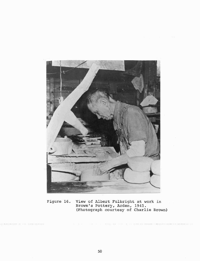
Figure 16. View of Albert FUlbright at work inBrown's Pottery, Arden, 1941.(Photograph courtesy of Charlie Brown)
50
WEAVERVILLE AREA SETTLEMENT
The town of Weaverville is located nine miles north ofAsheville, along the road between Asheville and Burnsville, nowcalled Highway 19-23. Reems Creek, a major tributary, runs eastwest, and drains into the French Broad River west of Weaverville.The earliest Anglo-American settlement was situated along ReemsCreek valley, south of Hamburg Mountain which also extends eastto west. Local history states that Dry Ridge was an early namefor Hamburg Mountain but was also used as the name for the firstpermanent settlement in the area. John and Elizabeth Weaver,andtheir son Jacob, from Virginia, were the first recorded settlersto establish a home on Dry Ridge in the 1780s. The Weavers hadsix daughters and four other sons, the descendants of whom settled in the immediate vicinity. The name of the settlement laterbecame Reems Creek and a post office was established there in1850. By 1872, the town was once again renamed, this time toWeaverville. The name change was in honor of Reverend Montraville Weaver, a benefactor of land and monies to WeavervilleCollege, established in the same year. An early description,states that "in 1874 the town limits extended one-half mile inall directions from J.W. Vandiver's store building, which is nowthe Feed and Seed Store on Main Street, operated by E.S. Leonard"(Pickens 1962:12). A 1903 map of Weaverville showed a factorylocated just south of town, a blacksmith shop, a school, and achurch, as well as settlements along Reems Creek and north towards Flat Creek.
Five pottery sites are located in the Weaverville area. TheDonkel pottery sites are located along Reems Creek, about 1.2miles east of Weaverville. The Brankton Post Office was locatedhere in 1903, in a store owned by the Brank family (George Donkel's landlord and later, father-in-law). The Cheek pottery siteis located about .5 miles north of Weaverville, where the Asheville/Burnsville Highway forks west, and south of Clarks Chapel,(established in the early 1800s). The Lankford pottery site islocated 2.3 miles north of Weaverville, on the Asheville/Burnsville Highway, in the Stockville community. The McClure/Yodersite is located in Weaverville, on the north side of ChurchStreet (formerly known as Cherry Street).
THE DONKEL SITES (31Bn381 and 31Bn3821
Historical Investigation for Both Donkel sites
The Donkel pottery sites (two locations), also known as theReems Creek pottery, are probably the most well known of theWeaverville potteries researched during this project. The Donkelsites, like the Stone/Penland and Bachelder sites, have receivedsome attention from local researchers in recent years. A summaryof this cinfo't"mationcfollows. cFo't"--- fu't"therccinformation cthe authorrefers to the previous work by Zug (1986), Dillingham (1981),Roberts (1989), and Leftwich (1989).
David Montgomery Donkel (born ca. 1866) and George BentonDonkel (born ca. 1869) were the two youngest sons of Dr. Isaac K.
51
Donkel and his wife Maggie Hill. Three older sons were Lloyd,Lawson, and John. Records show that Maggie Hill was Isaac'ssecond wife. The Donkel family moved from Williamsport, Pennsylvania to the Catawba Valley of North Carolina sometime shortlybefore 1880. The 1880 census records of Newton Township in Catawba County listed Isaac K. Donkel, age 74, disabled and retired,his wife, Maggie, 50, and sons, Lawson, 18, John, 16, David, 12and George, 7. The oldest son, Lloyd, resided in Orange County,Florida and managed an orange grove.
While residing in Catawba County, David and George learnedthe pottery trade. Historical records do not clearly revealwhere the Donkel brothers received their pottery training, buttheir association with Colin Monroe Yoder and S. Levrick Yoder ofthe Blackburn community offers a possibility. It appears thatLevrick Yoder left Catawba County and moved to Weaverville wherehe joined in business with Seree Wheaton McClure, (McClure/YoderJug Factory). Memoirs of Minnie Brank Roberts, George Donkel'ssister-in-law, state that the Donkel brothers knew S.L.Yoder andworked at his pottery works in 1897 when they first arrived fromCatawba County. Land deeds also revealed that George Donkelowned a town lot in Weaverville, adjacent to the MCClure/Yoderpottery site from 1899 until 1902. Deed records showed S.L.Yoderbought two town lots in the same block, one dated 1885 from J.A.Reagan, the other dated 1897 from G.A. Brandt. In 1901 and 1905,Yoder was again listed as selling his town lots to E. Byerly(this connection will be further explored in discussion on theMcClure/Yoder site).
The Donkel brothers became familiar with the clay resourcesof Buncombe County through their travels peddling Catawba Valleypots in Weaverville. Their father, Isaac, and brother, John,died in Catawba County. Later, around 1897, Maggie Donkel andher two sons, George and David, moved to Buncombe County. Assoon as was possible, the Donkel brothers made preparations toset up their own pottery shop. A rich source of stoneware claywas discovered along Reems Creek east of Weaverville on theproperty of R.J. Brank. George and David signed a land leaseagreement with Brank on January 1, 1898:
The contract and agreement made between R.J.Brank, D.M. Donkel, and G.B. Donkel. First R.J.Brank agrees to lease to said Donkel and Bro.the Reems Creek Pottery and the land that isunder fense[sic] with it including Clay-bedbeing two (2) acres more or less for the spaceof twelve (12) months. Brank agrees to let saidDonkel and Bro. have the use and full charge ofall on the inside of this boundary named for thespace of twelve (12) months and if Donkel andBro. shall then see cause to quit or not releasefor.longerperiod,thenall machinerYibrickoffurnace, and lumber bought not being cut fromtimber on my (Brank) farm belonging to him ismovable being theirs. Said Donkel and Bro.agree to pay R.J. Brank twenty four ($24.00)
52

and all there on. Payments due every six (6)months this the first day of Jan. 1898 to thefirst of Jan. 1899. D.M.Donkel. G.B. Donkel.
Also the meadow or swamp and stock land onthe left of swamp extending to fense[sic] whichsaid Donkel had in corn last year the swamprunning on line which I now have wheat sowedthrough to Buckners line. Said Brank agrees torun a wire fense[sic] around swamp. Donkel andBro. agrees to R.J. Brank for the same Ten($10.00) dollars it being in our possessiontwelve months this Jan. 1st 1898 till Jan. 1st1899.
G.B. DonkelD.M. DonkelR.J. Brank
The reference to Reems Creek Pottery, cited above, and the factthat Donkel had a corn crop on Brank's land the previous year,strongly suggest that the Donkels may have arrived in BuncombeCounty earlier than 1897, possibly around 1895 (Dillingham,personal communication).
An abandoned log house on Brank's property became the Donkelhomeplace. The pottery shop, located on the north side of ReemsCreek Road, was "built into the dugout hill behind the house"(Roberts, n.d.). The logs and lumber for the pottery shop hadbeen sawn at Robert Brank's saw mill, located south of the roadon Reems Creek.
Just at the end of the saw mill, George and Davebuilt a shed where they ground their glass withwater power, for glazing of their pottery. Theyobtained glass for this purpose from stores andbuilding contractors. The kiln for burning thepottery was built in the flat land near to theReems Creek Road (Roberts, n.d.).
David Donkel married Emma Wagner in 1899 and another roomwas added to the log house. Shortly thereafter, David and Emmamoved to Ellers Cove, where they bought land from Emma's fatherand built a house. By 1902, David had given up pottery making tobecome a full-time farmer. The 1902-1903 land release from R.J.Brank had only George's signature. George and his mother continued living on Brank's property under yearly lease agreements."George built a little store near his kiln, and carried a smallline of goods forsale""andservedastheBrankton,N;C;postoffice postmaster" (ROberts, n.d.).
In January 1908 George bought land (3.75 acres) from RufusWeaver on the south side of Reems Creek Road, and .5 mile west ofBrank's place he had been renting. There he built a house, barn,brick ...kilnj ...and···log ..potteryshop···(Figure17)·,···· He moved all of···his pottery equipment to this location and reestablished ReemsCreek Pottery. Here his mother died. In 1908 George marriedHannah Brank (daughter of R.J. Brank) and in 1910 they had a sonnamed Lawrence. The land George had previously rented was then
53

Figure 7. Vieo/ of Reems Creek Pottery in 1917, Donkel Site (Presnell Property).(William Barnhill Collection, Mars Hill College)
deeded to Hannah in 1915. Soon afterwards George built a largeframe house on the lot where the old log house had stood andmoved their home back down the road to this new house. He rentedout the smaller house located on his property but continued tooperate the pottery shop at that location until 1936.
A series of black and white photographs of the Reems CreekPottery and George Donkel were taken in 1917 by a travelingphotographer named william Barnhill. Though the shots wereobviously "staged", they provided a valuable record of this earlycottage industry and more specifically, Donkel's operation(Figures 17, 18 and 19).
Hannah Donkel died in 1918, and a year later George marriedher cousin, Luanna Bowen, to help raise their son, Lawrence. Hissecond marriage produced no children. Lawrence died of tuberculosis in 1933 at the age of 23. George, stricken with intensegrief, gave up making pottery for a while. In 1936, he moved hispottery equipment back to the original location of Reems CreekPottery. There he built a new kiln and shop several yards east ofhis first shop, nearer to Reems Creek Road, and southeast of hishouse. This shop, built of wooden planks, was equipped with twowheels for turning wares. George operated his shop with hisnephew by marriage, Talman Kermit Cole ("T.K."), until around1940. The location of his second shop was sold to T.K.'sfather(Donkel's brother-in-law) and later, in 1936, to Milton Presnell.Milton's widow, Edra Presnell remains the current owner of thissite. The barn and spring house built by Donkel in 1909 arestill standing, but a new brick house was built in 1948 just westof the smaller, frame house Donkel had rented out. GeorgeBentonDonkel died on December 31, 1956, one day before his birthday.
Numerous intact pieces of Donkel's pottery were examined andphotographed. During partnership with his brother, the Donkelsused a "D & D THE BEST" stamp. After David resigned from potterymaking, George began using a key impression to mark some of hispieces. Dillingham has hypothesized that the key was used tosymbolize the state of Pennsylvania, the Keystone state andDonkel's home (Dillingham, personal communication). Capacitystamps were also used.
Having been trained in the Catawba Valley tradition of alkaline glazed stonewares, the brothers continued to produce twovarieties of alkaline glaze; one made with crushed glass, theother with crushed iron ore added. Records of interviews withT.K. Cole specified that prior to 1935, three glazes were used byGeorge; the two alkaline mixtures and albany slip (Leftwich,personal communication). The glass was obtained from WestallLumber Company ·and ··the iron· ore· from Beech Glen·farm· in· EllersCove. Ore and glass were crushed together. The iron ore produced a rich black, glassy glaze and the glass-only mixture wasclear to pale green in color. Most vessel forms produced at theshop were basic utilitarian containers. George, a traditionalpotter···to··the... end,was•.. reluctant.. to•.... make.the.transitionto .. IIart...forms". But with encouragement from T.K., Donkel created a fewelaborately decorated and painted terra cotta urns and vases(Figure 20).
55
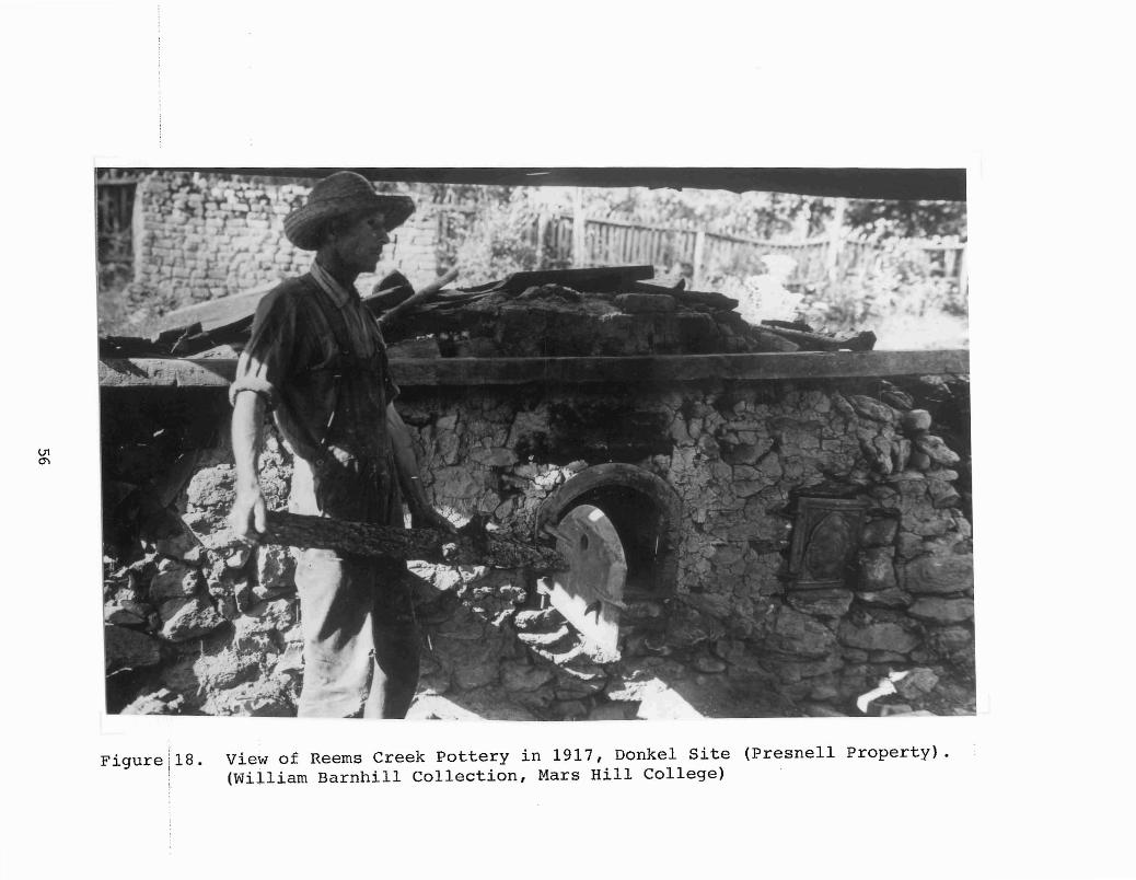
Figure 18. View of Reems Creek Pottery in 1917, Donkel Site (Presnell Property).(William Barnhill Collection, Mars Hill College)
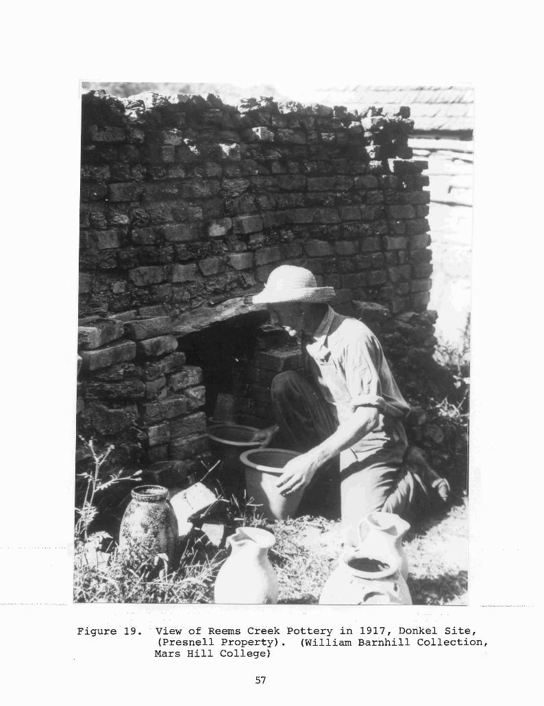
Figure· 19. view of Reerns Creek Pottery in 1917, Doriked Site,(Presnell Property). (William Barnhill Collection,
Mars Hill College)
57

Figure 20. View of terra cotta vase by George Donkel.
58

THE DONKEL SITE (PRESNELL PROPERTY =31Bn381)
Archaeological Investigations
This site was the location of Donkel's second pottery whichoperated between ca. 1908 until 1936. Permission to conduct archaeological investigations was granted by the owner. An on-siteinterview with Mrs. Presnell on June 8, provided useful data onextant structures, property alterations, and areas of archaeological potential. A large garden occupies the entire northwestcorner of the property where the log shop once stood. Judgingfrom Barnhill's photographs, the Presnell house, built in 1948,stands near the kiln and pug mill area. Alfalfa crops coveredthe bottomland (behind the house lot).
A map base (datum) was set in on the north edge of the lot,parallel to the garden edge. A row of 2x2-foot test units (1-7)were laid in at 10-foot intervals in a north-south alignment andtwo feet east of the garden (Figure 21). After excavation ofthese units, two units (8 and 9) were dug in the extreme northwest corner of the garden where no crops were planted. No testing was done in the remaining area of the garden but severalsurface collections were made after rains.
In the row of test units closest to the garden, two distinct plowzones were exposed. West profiles were recorded inthese units (Figure 22). Topsoil was deeper in the units south,downhill. Sterile subsoil was encountered between 1.4 and 1.7feet below surface. A second row of units (10-15), 15 feet eastof the first row, also was excavated. A third row of units (16-21) was placed 15 feet east of the second row.
The units closest to the house yielded numerous glazed brickfragments, remnants of a dismantled kiln. In Test unit 17A afired reddish clay feature was encountered 2.7 feet below groundsurface. This unit was later expanded into a 5x5-foot unit,(Test unit 17B), to expose and identify the feature (Figure 23).Over 1100 artifacts, mostly pottery sherds and brick fragments,were recovered from this unit. Excavation revealed a possibleside wall of the relict rectangular kiln, however, no intactstructural elements remained.
Test unit 18 was not excavated because of its close proximityto the well and pump. No other units revealed any structuralremnants. A total of 20 2x2-foot units, and one 5x5-foot unitwere excavated at this site. Fieldwork was concluded on June 25.
Artifact Summary
Table 9 presents a summary of materials excavated and collected from the Donkel site on the Presnell property. Of thetotal 3,384 artifacts 42% (n=1,423) were Vessel sherds, and 36%(n=1,236).wereArchitecturalDebris····suchasbricks··and···w·indow·glass fragments. Miscellaneous historic artifacts were abundant(12% or n=409), because the property has been continuously occupied as a residence since the late nineteenth century. ByProducts and Residue category consisted of slag, cinders, coal,
59
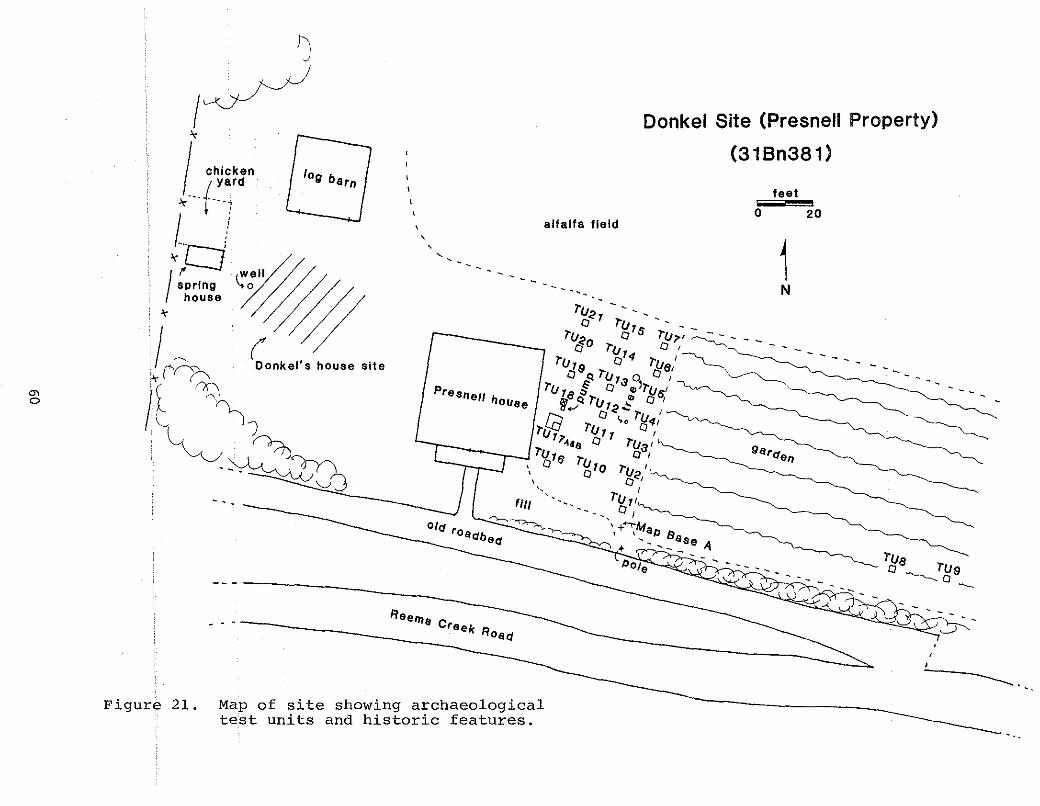
'"o
hI
J,
log barn\
\
alfalfa field
,..... - ........ - - -- -.....
"""" ..
II Property)Donkel Site (Presne
(318n381)
feet,,",",iil!!'!!";;'20o
1N
------
F 21. logicalrchaeo'te showing a,c features.Map of ~~s and historltest unl
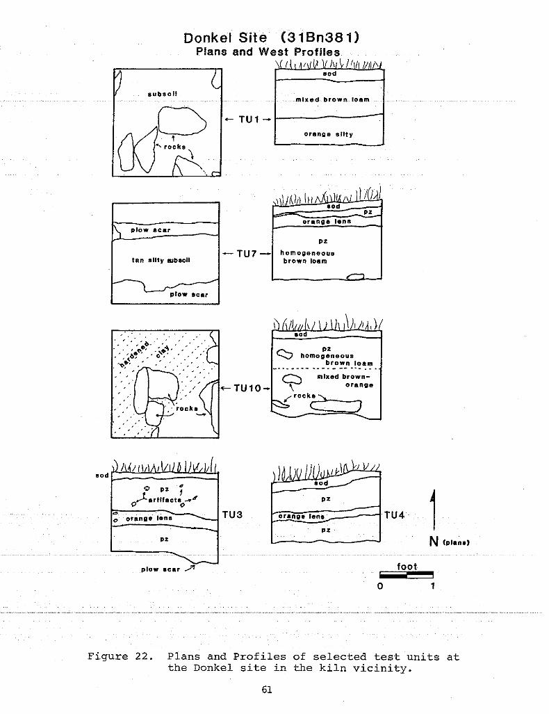
Donkel Site (31 Bn381)Plans and West Profiles
I !l
subsoilmixed brown loam
... TU 1 _ 1--------""'1orange silty
\ ploW scat
tan silty SJbsoll
-L
plow scar
orange lens
pz
- TU7 _ homogeneousbrown loam
mixed brawnorangeC?,{ rock.;a~>-__-.
r-... pz-V homogeneous
brown loam_.. - . - ~ - . --- - -- .. - . - ..
~TU10-
. ... '" "' ... -
" ' " i.. . . " . ... ' ;'.~~' ..~~~ ... ,'" .,' .-', ,~...... '.'"• ,,<,~.... '" ... .......
, .
() orange lens
pz
TU3
pz
boe!r~a~n!g~.~I~an~.~=::::::::iTU4pz 1
N (plana)
plow acar .,..,?r foot
o 1
Figure 22. Plans and Profiles of selected test units atthe Donkel site in the kiln vicinity.
61

Donkel Site(31 Bn381)
i J 1.\0.od
)
brown loam
yellow/tan
IUbaoll
fire-hardened?
,"... .... ... t....... - ... - - _ !tb.r'Ck I
... - - - - - - -:::: ~1)3
"
1 decomposed bricks
West Profile
brick flecks
2.8 It
/////~/.a/0// ;;;;:~y//'" bee; 7'/'/'. f.& ::(/ \
rock 8 \...:JrJ -" I'..{g'e:0 "......!E:0:.:e
__ _J:mottled brown loam
yellow Ita"subaoU
2.0 It
Plan
1.2 II L-_= .....Il.75 It
N - foot
o 1
Figure 23. Plan and Profile of Test unit 17B showingfire-hardened clay and bricks fragmentsfrom kiln.
62

Table 9Summary of Artifacts from the Donkel (Presnell) Site
Non- Kiln Archi By Prodl MiscProvenience Vsl Vsl Fum Deb Residue Hist Lith Total
T.U.l 3 0 0 6 8 7 0 24
T.U.2 13 0 0 22 0 14 0 49
T.U.3 16 0 0 24 0 9 0 49
T.U. 4 29 0 0 24 3 4 0 60
T.U. 5 32 0 0 8 0 2 1 43
T.U.6 29 0 0 8 16 11 0 64
T.U.7 49 0 0 23 8 10 1 91
T.U.8 0 0 0 0 5 0 6
T.U.9 1 0 0 3 0 0 0 4
T.U.l0 10 0 0 18 2 0 1 31
T.U. 11 48 0 0 18 1 1 1 69
T.U.12 34 0 0 50 1 5 0 90
T.U. 13 15 0 0 52 8 5 1 81
T.U. 14 19 0 1 63 2 20 3 108
T.U.15 12 0 0 31 3 14 3 63
T.U.16 67 0 1 93 77 22 0 260
T.U.17A 151 0 0 244 59 40 1 495
T.U.17B 527 0 2 438 100 105 0 1172
T.U.18 0 0 0 0 0 0 0 0
T.U.19 8 0 0 40 11 6 0 65
T.U.20 15 0 0 33 0 48 0 96
T.U.21 10 0 0 22 0 25 0 57
Surface:Garden 327 0 0 14 0 52 1 394
Surface:Creek Bank 8 0 0 1 0 4 0 13
Total 1423 0 4 1236 299 409 13 3384Percent 42 0 0.2 36 9 12 0.8 100
63

from both pottery activities (slag and iron residue) and homeheating sources (coal, clinkers, and cinders). Only four piecesof hand-made kiln furniture (wads/props) were found at the site.This finding suggests that Donkel did not frequently stack waresin the groundhog kiln he used. Several prehistoric lithic artifacts, (i.e., projectile points, cores, bifaces, flakes etc.)were also recovered in the upper plowzones. These items date tothe Middle to Late Archaic cultural period.
Of the pottery fragments from the site, the majority werealkaline glazed stoneware. A few albany slipped sherds werenoted; interestingly, all of these were overfired. The alkalineglazed sherds also exhibited some evidence of misfiring, bothover and under. Three glazed body sherds were found with the keyimpression (George's mark), and one sherd was marked " •• & D•• EST"(the partnership mark). Some unglazed earthenware and stonewarefragments were present as well.
A total of 93 rims were analyzed for vessel form variation.Eleven pieces were unglazed, the remainder glazed. Crock rimsnumbered 61, followed by jars at 19, pitchers at 4, churns at 3,jug tops at 2, and one each of cup, bowl, and canister(?). Onerim could not be identified as to form. Jar rims were segregatedfrom crock rims if they had a recessed interior lip for lidplacement, and a narrower orifice.
THE DONKEL SITE (CHURCH PROPERTY =31Bn382)
Archaeological Investigation
The next Donkel site, located half a mile east of the previous Donkel site (31Bn38l), is on the north side of Reems CreekRoad (S.R.#1003). The property is now owned by the United Missionary Baptist Church. Information received from local residents indicate that this lot was the site of George Donkel's last(third) pottery shop. Its period of operation was from 1936until ca. 1944. The site of his first shop, of the 1898 to 1907period, was just west of this lot. It is currently owned by theHunnicutt family. The lot between these two locations is now theMorris property but was once the rich clay-bed that attractedDonkel to the site.
Landscaping for modern appurtenances appears to have beenextensive at the original Donkel homeplace. For this reasonarchaeological reconnaissance efforts concentrated on the site ofhis third operation (the Church lot). Fieldwork was conducted onJune 22 and 24. After permission was obtained for testing, tenshovel tests were excavated across the site. A site map (Figure24) was constructed. Datum was located 20 feet north of the roadand shovel tests were oriented north-south at 10-foot intervals.Oral information provided by the property owner combined withresults of excavation confirmed that subsurface disturbances wereextensive. .Approximatleytwoto··· 2.5 . feet of· topsoil: .had beenstripped from the site. This lot had later been used as a stockpile for road gravel. More recently, landscaping for the newchurch had further modified the property. Substrata consisted ofcompact gravel or red clay fill. A few glazed brick fragments
64
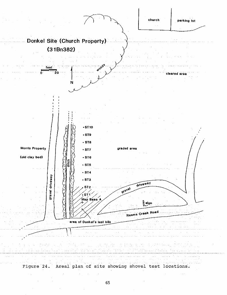
Donkel Site (Church Property)
(31Bn382)
church parking 101
(old clay bad) • S1e, .c
u"' ~ • ST5
feet5
o 20
Morris Properly
,.,..~..>;:"0
Gi>..~
'"
1N
I.,,•
f #t·STlO
·S19
• S18
• S11
• S14
• S13
graded area
C·· reek RoadReams
cleared· area
area of Donkel'sl8s1 kiln
Figure 24. Areal plan of site showing shovel test locations.
65

were found in shovel tests 4 and 6. No other evidence of astructure was encountered.
Artifact Summary
Test excavations at this site yielded 43 total artifacts (seeTable 10). No surface collection was feasible because of recentgravel deposits. Of the total, 86% (n=37) was architecturaldebris (brick fragments). The bricks were manufactured firebrickand composed of two different clays marbled together.By-Products, Miscellaneous Artifacts, and Lithic categories wererepresented by single items. No pottery was found.
THE MCCLURE/YODER SITE (31Bn383)
Historical Investigation
The earliest published reference to the McClure/Yoder potterysite came from a local history volume dated 1962 by Nell Pickensand entitled, Dry Ridge: Some of its History, Some of its People.As previously mentioned, Dry Ridge was an earlier name forWeaverville. In this book, under a photo of Wheaton McClure, theauthor stated that, "The McClures and the Yoders ran a popularjug factory on Church Street from about 1850 to the turn of thecentury" (Pickens 1962:91). It was further stated that,"Mr.Homer Casto and Mr. E.S. Leonard live on the site of what wasa popular and well known Jug Factory started by the McClure andYoder families nearly a century ago" (Pickens 1962:106). Archival research conducted during this project, and research conductedby previous investigators (Leftwich and Roberts), could notproduce any evidence to verify an 1850 to 1860 starting date forthis "Jug Factory". A founding date of 1880 is more likely,given the following archival data.
S. Levrick Yoder (born ca. 1829, died post-1900), co-owner ofthe shop, did not appear in Buncombe County census records until1900. Property deeds indicate that Yoder bought a town lotfronting Broad Street in Weaverville in 1885 from J.A. Reagan(Deed Book 50:167). In 1897 he purchased another lot from G.H.Brandt (Deed Book 121:334). Finally, in 1901 and 1905, Yodersold his two town lots to E. Byerly. Clyde Byerly, a relative ofE. Byerly, later sold the lots to E.S. Leonard who built thehouse now standing on the property. In 1971 Miss Sue McElroy,the current owner, purchased the house and lots from Leonard.
Yoder, a skilled potter, migrated along with his mother toWeaverville from the Catawba Valley region of North Carolina. Hewas the youngest son of Cyrus Yoder and the first cousin of ColinMonroe Yoder (born 1863, died 1953), a well-known potter whooperated a shop near Blackburn, Catawba county, North Carolina.It.islikely that .Levr.ick reC:Elived .11is.pottery .tor<iin~nCJ....at hiscousin's shop.. The Donkels and the Yoderswereprobablyacquainted or associated with each other prior to theirrelocation in Buncombe County. How the Yoder and McClurefamilies became associated was not clearly demonstrated in the
66

Table 10Summary of Artifacts from the Donkel (Church) Site
Non- Kiln Archi By Prodl MiscProvenience Vsl Vsl Fum Deb Residue Hist Lith Total
S.T.l 0 0 0 0 0 0 0 0
S.T.2 0 0 0 0 0 0 0 0
S.T.3 0 0 0 1 2 0 0 3
S.T.4 0 0 0 3 0 0 1 4
S.T.5 0 0 0 0 0 1 0 1
S.T.6 0 0 0 21 0 0 0 21
S.T.7 0 0 0 12 0 1 1 14
S.T.8 0 0 0 0 0 0 0 0
S.T.9 0 0 0 0 0 0 0 0
S.T.l0 0 0 0 0 0 0 0 0
Total 0 0 0 37 2 2 2 43Percent 0 0 0 86 4.6 4.6 4.6 100
67

available historical documents. It could be that McClure, likeRutherford, provided the capital and/or property to set up thepottery and then hired Yoder to turn the wares. Moreover, itcould not be firmly documented that Wheaton McClure was anythingother than a co-owner; he may have been a potter. A familialconnection between the two was suggested in the 1900 censusrecord for Reems Creek Township. There S.L. Yoder, age 70, waslisted as a "boarder" with Eliza J. McClure, age 48 and head ofhousehold (possibly an aunt or older sister of Wheaton). Herresidence was on the north side of Weaverville and next toWilliam B. Cheek. The census listed Yoder as a widower, thoughfamily accounts say he was a bachelor who died and was buried inWeaverville. No death record has yet been found.
Records of the McClure family appear in Buncombe County,particularly in the Weaverville area, from the 1860s on. Mary E.McClure was Postmistress for Weaverville in 1865. The 1880census records listed Robert McClure, age 25, as head of household along with his sister, Eliza, 28, a brother, Burns (?), age31, and Wheaton, age 14. Pickens (1962:91) stated that Wheatonwas a student at Weaverville College in the 1880s. In 1891,Wheaton purchased 68 acres of land from Eliza McClure. Thefollowing year he bought a town lot in Weaverville from W.C.Lewis (Deed Books 76:231 and 85:349). He was not listed in the1900 or 1910 county census records; however, local informantsstated that "he was born and raised on what is currently NorthMain street in Weaverville" (Roberts, n.d.). He died in MadisonCounty, North Carolina in 1960 and was buried in Walnut.
Only one other reference was located regarding this potterysite. The county court minutes of 1893/4 recorded a complaintand ordinance filed ordering the pottery shop owners to "fill inthe ditch adjacent to their operation," which had become a publicnuisance or hazard (from Leftwich records). Given the historicaldata reviewed by this researcher and others, a date of operationfor the McClure/Yoder "Jug Factory" was probably mid-1880s untilcirca 1905; a twenty-year-span rather the fifty posited by Pickens. Consequently, little was learned about the types of wares,glazes, or kiln used at this manufacturing site. It appeared nomakers stamps were known for these potters or their wares. Asingle intact jug (which, according to local tradition, was madeat this site) was photographed and examined. This specimen iscurrently property of Dry Ridge Museum.
Archaeological Investigation
Fieldwork began on JUly 8 and ended on July 13, 1989. Thesite is located in the rear yard and garden of the McElroy house(formerly owned by Leonard), on the north side of Church streetin Weaverville. An on-site interview with the current owner, age95, provided useful land title information. Unfortunately,little. data regarding site history. anci.. modif icationc()ulci.berelayed because she did not own the property prior to 1971. Aneighbor now living on the old Casto lot, stated that during the1950s the garden areas of both lots were cleared for cultivationand "truck loads of old brick, pottery and stone were carried off
68

the site" (Margaret Cooper, personal communication).Systematic surface collections through the garden rows
yielded hundreds of artifacts including pottery sherds, glass,glazed bricks fragments, slag, and abundant domestic-relateddebris. The garden area, approximately 7980 square feet, coveredthe central portion of the block (Figure 25). Excavation in thegarden area was not possible because of crops. Therefore, testunits were laid out in a grid pattern across three adjacent landlots surrounding the garden. Nineteen 2x2-foot units were excavated and a detailed site map constructed. Depths of unitsranged from 1.0 to 1.5 feet. sterile subsoil was a dense redclay. Most units revealed fairly homogeneous and consistentstrata across the site. Only sample profiles were drawn.
In unit 7 a shallow brick pier(?) or footing was exposed(Figure 26). This feature consisted of three brick bats laidhorizontally. Several large pieces of window glass were alsofound associated with this feature. The contiguous bricks couldrepresent a corner footing of a shop or an extension of theextant garage which was later removed. No other intact structural remains were discovered. A few loose fragments of glazedbrick came from unit excavation.
Artifact Summary
A total of 1,913 artifacts were recovered from test excavations and surface collections at the MCClure/Yoder site. Table11 presents a summary of those items by seven artifact categories. Vessel fragments comprised 41% (n=487), followed by Miscellaneous Historic with 25% (n=487), Architectural with 20%(n=387), and By-Products with 11% (n=204). Numerous prehistoricartifacts were included in the Lithics category, with 3% (n=52)of the total assemblage. projectile points of chert and quartzwere found at the site along with other knapping debris. Theseartifacts date from the Late Archaic to Early Woodland culturalperiods. Surface collections from the garden represented 49% ofthe total assemblage while excavation units produced 51%. Testunits 1, 12, and 7 each contained more than 100 items. No kilnfurniture or non-vessels were found. The lack of kiln furnituresuggests stacking of wares in the kiln at this site was uncommon.
From vessel fragments, a total of 71 rims were available forform analysis. Of these, only five were unglazed while all theothers were' alkaline glazed. No albany slipped. pieces were foundhere. Crock forms with straight rims were the most frequentrepresented by 37 sherds. Twelve jar rims were present alongwith six jug tops, four pitcher .. rims, ···threeunglazed flowerpotrims, and one each of a plate and cup. Seven rims could not beidentified as to form. Alkaline glazed sherds exhibited variousshades of pale to dark green and a few had rutile present.Rutile (titanium dioxide) occurs naturally in the clays of theregion. When·fired·it···turns·abluish·color·· fringed with milkywhite.
Though no known marks were used by the potter(s) at thissite, several body and rim sherds exhibited incised banding,scalloping, or other random lines. These may represent portions
69
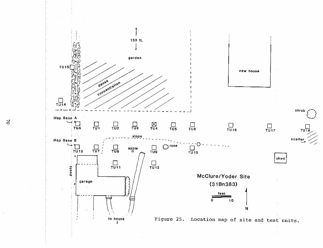
shrub 0o
TU1~
%scatter %
~ //
oTU17
1
new house
oTU16
feet
o 10
McClure/Yoder Site
(318n383)
oTU6
oTU5
[gITU4
o 0 r,,~e· - . - .0- 0 - -TU9 TU10
oTU12
oTU3
garden
appleo
I
I
I
%'---- -------- J
oTU2
oTUB
oTUl1
slope-------------------
oTUl
,0:
TU7
_. - - - - .t-----t-~-fV
garage
i133 ft.
I
";;"CJ.
Map Base A
'-'0TUA
Map Bsse 8
'-"0TU13
--.Jo
N
to houseI
Figure 25. Location map of site and test units.

Figur~ 26. Pl~n Niew of Test unit 7~ McClure/Yoder Site.

Table 11Summary of Artifacts from the McClurelYoder Site
Non- Kiln Archi By Prod! MiSeProvenience Vsl Vsl Fum Deb Residue Hist Lith Total
T.U.1 48 0 0 35 9 49 0 141
T.U. 2 8 0 0 9 1 8 2 28
T.U.3 2 0 0 3 0 2 0 7
T.U.4 0 0 0 0 0 0 0 0
T.U.5 3 0 0 3 0 2 0 8
T.U.6 11 0 0 12 13 14 3 53
T.U.7 9 0 0 99 13 11 3 135
T.U.8 19 0 0 13 7 11 3 53
T.U.9 15 0 0 30 4 11 0 60
T.U.10 14 0 0 10 3 9 0 36
T.U.11 29 0 0 24 10 13 1 77
T.U.12 9 0 0 76 2 16 5 108
T.U.13 6 0 0 5 18 20 2 51
T.U.14 14 0 0 2 2 7 1 26
T.U.15 3 0 0 2 6 1 0 12
T.U.16 28 0 0 10 4 6 3 51
T.U.17 26 0 0 3 7 4 2 42
T.U.18 9 0 0 5 1 8 1 24
T.U. A 10 0 0 4 39 13 0 66
Surface:Garden 510 0 0 38 65 280 25 918
Surface:Behind Cas-to House 10 0 0 4 0 2 1 17
Total 783 0 0 387 204 487 52 1913Percent 41 0 0 20 11 25 3 100
72

of names, marks or decorative motifs. One such sherd from Testunit 1 appeared to be incised "Yo .• " (for Yoder?) near the base.Incised banding on the necks and shoulders of some vessel formswas a common decorative.. technique used by potters in. the. CatawbaValley region where Yoder originated.
THE CHEEK SITE (31Bn3841
Historical Information
The Cheek family were early residents of Buncombe County whosettled in Weaverville before 1850. William Bishop Cheek, age29, appeared on the 1850 census record along with his wife, Ann.By 1860 a son named James R., age 1, was listed in W.B. Cheek'shousehold. In 1880, W.B. Cheek's occupation was listed as"tanner", and his son, James R., age 21, was still living at hisfather's farm. James had married Mary Lankford, age 19, by thistime. The records for 1900 showed W.B. Cheek, 76, and James R.Cheek, 41 in two neighboring households. The father was stilllisted as a tanner and James' occupation was listed as a teamster. Teamsters were wagon owners and operators who made theirliving by hauling goods. Information from an interview withLester Cheek, James' son, indicated that his father hauled goodsto Madison and Yancey counties. It also was learned that hisgrandfather, W.B., maintained an apiary in addition to his tannery. Some of the goods hauled by James were honey, wax, tanneryproducts and eventually, pottery.
By 1910 the James Cheek household had increased to eightchildren. His mother-in-law, Mary Briton, also was living withthem. William B. Cheek died in 1910. Sometime prior to the late1890s, James decided to try his hand at pottery manufacturing.Providing the land and capital, Cheek, who was not a potter,hired his brother-in-law and nephew, Joe and Jeter Lankford toturn wares. The Lankfords were from stockville, a small community in the Flat Creek area north of Weaverville. Where or fromwhom the Lankfords learned the pottery trade has not been revealed in historical records. The Lankfords worked at Cheek'sfor a short while and then departed to set up their own shop nearstockville. Cheek then hired James Henry stone from Jugtown (inCandler) to turn wares. Leftwich suggested that Finley, James'son who died. at the. age of 18, may have learned to make potteryfrom Stone (personal communication). stone was the last potterto work at the site before it clOsed around 1911.
The CheekhomeplaceTwherethepotterywasbuilt,·is locatedimmediately south of Clarks Chapel just north of Weaverville.The site consists of several acres with remnant gardens, a springand creek, orchards, and a log house built by William Cheekaround 1880. Prior to this project interviews were held with the
...... lastowner/occupantof.. thissitey···LesterCheek··C·born1898-died1988) • He remembered certain aspects· of the pottery operationwhich provided useful site-specific information (Leftwich, personal communication). There was a groundhog kiln, a hand-turnedpug mill, and a spring-operated glass crusher. Clay was hauled
73

in from the Flat Creek area by wagon loads. Wares were cartedaway and sold by Cheek. Alkaline glaze, of the crushed glass andiron ore mixture, was primarily used for the stonewares. Cheekcould not recall exactly when the shop and kiln were dismantled.
Archaeological Investigation
The site is located south of S.R.#1733, and at the south endof a gravel road which leads up to and beyond Clarks Chapel. Asmall unnamed creek which drains west into Garrison Branch beginsat a spring on the property. An on-site interview was conductedwith Lester's brother, James R. Cheek, Jr., from Georgia. Permission was granted for testing, and areas of archaeological potential were inspected.
Fieldwork began on June 25 and concluded on July 7. Apedestrian survey of the abandoned garden and driveway yielded asurface collection of artifacts. A map base, Datum A, was set ineast of the house, and south of the driveway, on a small hammock(Figure 27). Because of minimal ground visibility in the grassyfront lawn area, shovel tests were laid out at 10-foot intervalsextending south and west from datum. Twenty-two shovel testswere excavated to sterile sUbsoil, ranging from 1.0 to 2.8 feetin depth. An area of artifact concentration (from three shoveltests) was noted immediately south of the gravel driveway near asmall maple. TWO adjoining 5x5-foot units (test units A and B),and a 2x2-foot unit (Test unit C) were excavated in this area.
Here a portion of kiln foundation was exposed .7 foot belowground surface. The northern section of this brick wall was fourcourses in depth and appeared to be slightly curved in alignment(Figure 28). This finding suggests that the kiln may have beencircular rather than rectangular in design. Another possibilityis that the walls were severely warped from heat, age, groundpressure and/or later alterations which give it a false curvedappearance.
The other brick wall remnant extended south from this wall.Its alignment and glaze deposits on the inner surface of thebrick suggest a firebox was located here. Typically firebo~es
were situated around the perimeter base of circular kilns. Testunit C was excavated to a depth of two feet. Large tree rootsfrom a nearby maple impeded further excavation units to the west.
The underfired remains of three nearly whole stoneware jarswere found adjacent to the intersection of these two wall rem~
nants. One reconstructable crock was marked "J.H.STONE", thusverifying that stone worked for Cheek at this site. Over thirtypieces of kiln furniture, predominately shelf/slab fragments,were found in test units A and B. Landscaping for a new drivewayleading up to the house appears to have destroyed the north halfof the kiln. Two coins dating 1959 and 1960 were found in TestUnit A and may coincide with this period of landscaping. Sherdconcentrations·were·excavated ·in··shovel· ·tests··· 12and13iwhichare probably related to waster piles located adjacent to thekiln. All shovel tests and test units were backfilled and sodreplaced.
Finally, an interesting discovery of family history was made
74

r;" __ ,_
/ logI : J)e,.,
o
~\ ,0 0IJOlJlar e ~" ----·0
hill
ST2'
-:: +
'"ST1·
Map Base A
, ~
\ 0 appleST19·
ST20.
I / SloPeI 1/
I II/II .cedar 1/////
.eldero
Cheek Site(318n384)
woods
feet
o 20 1N
Fig~re 27. Map of site showing location of shovel tests and test units A, B, and C.
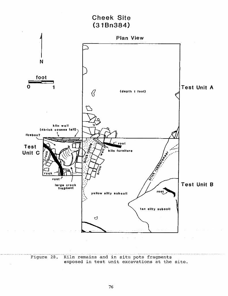
Cheek Site(31 Bn384)
Plan View
N
foot
o 1(deplh 1 loot)
Test Unit A
Test Unit Broo~
'kiln furniture
yellow silty subsoil
.' :.....(;.\::....'
large crockfragment
kiln wall(4brlck causes tall»)
firebox? \ I~~~T":-:::---J1
TestUnit C
tan silty 8ubsoll
Figure 28. Kiln remains and in situ pots fragmentsexposed in test unit excavations at the site.
76

at the site on the last day. In a grove of trees south of thehouse and uphill from the spring, several large beech trees (150to 200 years old) were found to have initials and dates carvedinto the bark. Readable names were Lankfords and Jameson, anddozens of initials. Dates ranged from 1910 up to 1940. Thisunique archival record provided a special personal connectionwith former occupants and visitors at this pottery site.
Artifact Summary
Table 12 provides a summary of artifacts found at the Cheeksite during excavations and surface collections. A total of2,583 items were identified and sorted into six artifact classes.Architectural Debris, mostly nails and brick fragments, comprisedthe largest category with 55% (n=1419) of the total. Potteryfragments numbered 725 or 28%. Shovel tests 12 and 13 and testunits A, B, and C contained abundant sherds. All other artifactcategories comprised less than 10% combined. Fifty-five piecesof kiln furniture recovered from test unit excavations provideevidence for stacking of wares in the kiln. The shelf/slab formsfound here closely resemble those recovered at the Trull andstone/Penland sites, and were probably made by J.H. Stone. Inaddition to kiln furniture, glazes and vessel forms were alsovery similar between these sites. Underfired pieces were muchmore frequent at the Cheek site, however, and may indicate problems with clay composition, firing temperature, or design defectsof the kiln. capacity and name marks were found on a few sherds.Not unexpectedly, they were identical to those seen on intactpottery pieces made by J.H. Stone at the Stone/Penland site.
Vessel form analysis was done on 64 rims from the collection. Crock forms were the most frequent with 25 rims present.Ten rim sherds were reconstructed into three nearly whole crocks.These crocks were 2 or 3 gallon capacity and all were underfired(Figure 29). Jars and unglazed flowerpots also were frequent,with 11 and 12 rims represented. One flowerpot rim was incisedwith a date of "189 •• " found in Test unit B. Other vessel formswere two cups and one pitcher. Three rims could not be identified as to form.
Surface collection in the garden east of the kiln area,recovered several artifacts dating from early-to-middle nineteenth century (e.g., kaolin pipe stem, creamware and pearlwareceramics, and dark green wine bottle glass). These domesticrelated artifacts indicated the nearby location of an earlierhouse site possibly predating the Cheek occupation.
THE LANKFORD SITE 131Bn3851
Historical Investigation
The Lankford site is located in the Stockville community 2.3miles north of Weaverville, on the east side of S.R.#2207 (alsocalled the Ashesville/Burnsville Highway). Information fromcurrent property owners, and a walk-over inspection of the lot
77

Table 12Summary of Artifacts from the Cheek Site
Non- Kiln Archi By Prod! MiseProvenience Vsl Vsl Fum Deb Residue Hist Lith Total
S.T.1 0 0 0 0 1 0 0 1S.T.2 2 0 0 1 1 0 0 4S.T.3 3 0 0 16 0 6 0 25S.T.4 1 0 0 1 0 1 0 3S.T.5 0 0 0 3 0 3 0 6S.T.6 3 0 0 3 0 1 0 7S.T.7 0 0 0 0 6 0 0 6S.T.8 3 0 0 2 3 2 0 10S.T.9 2 0 0 1 0 0 10 13S.T.10 7 0 0 25 25 0 0 57S.T.11 6 0 0 39 15 4 1 65S.T.12 76 0 2 87 14 0 0 179S.T.13 144 0 2 42 5 2 2 197S.T.14 33 0 0 12 34 7 1 87S.T.15 5 0 0 2 9 2 0 18S.T.16 10 0 0 1 10 2 0 23S.T.17 10 0 2 16 7 0 0 35S.T.18 21 0 5 99 2 2 0 129S.T.19 4 0 1 6 0 1 1 13S.T.20 8 0 0 7 1 0 0 16S.T.21 5 0 0 4 0 0 0 9T.U. A 142 0 27 477 17 53 3 719T.U. B 69 0 8 236 35 23 16 387T.U. C 98 0 1 328 11 2 1 441Surface:Garden 41 0 5 4 0 16 4 70Surface:Driveway 10 0 2 4 0 3 0 19Surface:Garden &Road 3 0 0 2 1 9 0 15Surface:General 19 0 0 1 7 1 29
Total 725 0 55 1419 198 146 40 2583Percent 28 0 2 55 7 6 2 100
78

Figure 29. View of reconstructed J.H.STONE crocks from the Cheek site.(Maximum height is 15 inches)

quickly revealed that this pottery site and been severely disturbed by recent landscaping and house construction. The potential for archaeological resources was considered minimal. Therefore, this site received the lowest priority of all ten potterysites researched and no archaeological investigations were conducted. Surface collections made several years ago by a localresearcher produced a few glazed kiln bricks and sherds (Leftwich, personal communication). These items were found in anembankment of the neighbor's driveway and may have been intentionally placed there to retard erosion.
Historical information concerning the Lankford pottery wasgarnered from census records and interviews with family descendants. Joseph Lankford (born 1842) appeared on the 1900 census asa photographer. Included in his household was a sister namedVelda. In 1910, Jeter Lankford, age 30 (born 1880), was shown inthe residence of Joseph Lankford, age 63. Their co-residence atthis time suggests that their pottery was in operation in 1910.When and where the Lankfords learned pottery making could not bedetermined through available resources. Leftwich (personalcommunication) stated that they may have worked for George Donkelat Reems Creek Pottery for a while, but this could not be verified from the historical records. The Lankfords may have beentrained by J.H. Stone while working at the Cheek pottery.
As previously mentioned, James Cheek's wife was a Lankford,apparently Joseph's sister. The Lankford men worked at the Cheeksite before it ceased operation in 1911 or 1912. It appears thatby 1910 their own shop in Stockville was operating. Familydescendants remember the pottery still in operation prior to WWI(Bailey Lankford, personal communication). A few intact piecesof pottery made at the site, but unmarked, were photographed inprivate family collections. Double strap handled molasses jars,and jugs of various capacities were popUlar items made at thisshop. The Lankfords used the common iron ore and glass combination alkaline glaze on their stonewares (Figure 30).
80

Figure 30. View of Lankfordmolassesjug~
81
CHAPTER 6SUMMARY OF ARTIFACTS FROM EIGHT POTTERY SITES
Because the stated purpose of this study involvedreconnaissance of primary field data, artifact analysis was limited to abasic level of catalogue description. Nonetheless, the preliminary artifact analysis should provide useful information inaddressing National Register eligibility determination and development of research questions.
Investigations at eight Buncombe County pottery sites yielded 11,261 artifacts, of which 42% (n=4,759) were pottery fragments. During field inspections and preliminary analysis a widerange of vessel forms, glaze varieties, and firing defects wereobserved on the pottery fragments. A summary of all artifactsrecovered during this investigation is provided in Table 13. Theartifacts were subdivided into seven separate categories based onrelevant associations to expedite analysis. The following discussion is a brief description of each category as presented inthe Laboratory Methodology portion of this report. The total foreach artifact category is shown in the summary table.
Vessels
All recognizable hand-made pottery sherds were classified byvessel attribute or portion (i.e., base, rim, handle, shoulder,body, or lid) and then quantified for each provenience. This wasdone to isolate diagnostic attributes for vessel form analysis.Unfortunately, analysis of rim sherds from each site was all timepermitted. This information was presented with individual sitedescriptions and will not be repeated here. Attempts were madeto correlate these rims with existing pieces of pottery fromprivate collections in order to recognize particular attributes.Crocks (with wide-mouth or flanged rim), jar (with smaller orifices and recesses for lids), churns (with taller collared rimand recesses for lids), pitchers, cups, jugs, flowerpot, bowls,plates, and utilitarian dishes were recognizable forms based onrim analysis. Questionable rims were placed in an unidentifiablecategory. Glaze variations were described for each site. Generally, alkaline glazed stonewares were the predominant glaze andvessel type.
Alkaline glazes occur on stoneware bodies and are unique tothe southeastern United States. The adjective "alkaline" refersto the use of calcined lime or wood ash as fluxing agents tolower the melting point of the glaze. Calcined lime containscalcium, while wood ash contains sodium, potassium, as well a.scalcium (Zug 1981:32). Alkaline glaze also includes silica,sources of which are sand, clay, quartz, feldspar, iron cindersor crushed glass. To process the glaze, water and clay slips areadded to keep the ingredients in suspension for coating the pots.
According·to ·zug·sresearch,allNorthCarolinapottersappeared to have used wood ashes (rather than lime) as a fluxingagent for their glazes (1981:32). For the potters of BuncombeCounty and the Catawba Valley, crushed iron ore (or cinders whereavailable) and glass were the preferred silica sources. In
82
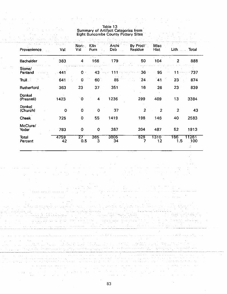
Table 13Summary of Artifact Categories fromEight Buncombe County Pottery Sites
Non- Kiln Archi By Prod! MiscProvenience Vsl Vsl Fum Deb Residue Hist Lith Total
Bachelder 383 4 166 179 50 104 2 888
Stone!Penland 441 0 43 111 36 95 11 737
Trull 641 0 60 85 24 41 23 874
Rutherford 363 23 37 351 16 26 23 839
Donkel(Presnell) 1423 0 4 1236 299 409 13 3384
Donkel(Church) 0 0 0 37 2 2 2 43
Cheek 725 0 55 1419 198 146 40 2583
McClure!Yoder 783 0 0 387 204 487 52 1913
Total 4759 27 365 3805 829 1310 166 11261Percent 42 0.5 3 34 7 12 1.5 .100
83

Buncombe County, however, where iron furnaces (and their subsequent residue) were not as frequent as in the Catawba Valley,natural deposits of iron ore were exploited. The iron ore wascrushed and substituted for iron cinders. Glass for crushing wasobtained from local builders, hardware stores, or collected bypotters from surrounding households.
The crushed iron ore glaze typically produced a dark brownto black color and was highly vitreous. The glass glaze varietytended to be clearer, lighter green and smoother in texture.Decoration with slips under the glaze was not practiced by thesepotters. Rutile (titanium dioxide), which occurs naturally inthe clays of this region, was visible on sherds from a few sitesin the Weaverville area (McClure/Yoder, Donkel, and Cheek). Itwas not seen on pieces from the Candler potteries, suggestingthat the clays in the two regions vary in composition.
It was difficult to determine if there was a particulartendency toward anyone shade or texture of alkaline glaze usedby the Buncombe County potters. One reason for this may havebeen the many factors which effect the coloration of alkalineglazes. Various combinations of glaze ingredients, placement ofthe wares in the kiln, oxidation or reduction atmosphere in thekiln, paste color of the stoneware, as well as consistency of theglaze mixture when applied (top of the barrel versus bottomsediments) effect the outcome of the glaze. Additional quantitative analysis of pottery sherds from these sites may reveal someglaze preferences or tendencies expressed by the Buncombe Countypotters.
Slip clay glazes also were recorded for several sites (Rutherford, Bachelder, stone/Penland, Trull, and Donkel). Thepresence of this glaze served as a temporal indicator. Popularuse of this glaze began around 1910 and was quickly adopted bymost of the previously mentioned Buncombe County potters (exceptDomkel). Earlier sites such as the Cheek or MCClure/Yoder wereout of business by this time; therefore, the predominant glazefound at these sites was alkaline. George Donkel's use of thisglaze was limited even though he continued pottery productionuntil 1940.
The distribution of albany slip glaze found among all thesites surveyed suggests that this glaze was not as popular topotters in the Weaverville area as it was to those in the Candlerregion. Another possibility may have been that the glaze was notcompatible with the clays in the Weaverville deposits and misfirings, like those seen at the Donkel site, were too frequent.
Albany slip was derived from a clay mined along the HudsonRiver in New York. It was powdered, shipped in bUlk, and available through local hardware stores. When mixed with water theglaze produced a creamy solution. Wares were dipped into themixture, dried and then fired to produce a smooth, chocolatebrown to black, opaque glaze. This glaze variety was the predominate glaze·used·at the Rutherford·site; Bachelderperfectedthis glaze and used it in many variations by adding other coloring agents.
Bristol glaze was a clay slip typically combined with anopacifier (tin oxide) to produce white to light gray glazes. It
84

was not popular among the Buncombe County potters, and only a fewsherds were found at the Bachelder and Rutherford sites.
Morphological analysis of vessel attributes received onlybrief attention during this phase of research. More extensiveanalyses would be required to examine variations in rim forms,handle styles, basal treatments, body composition, vessel forms,glazes, and marks/decorations on an intersite and intrasitelevel. Through this type of analysis, the characteristics ofeach potter's wor~. cQuld be discerned and identification ofunmarked pieces facilitated. Additional research on vesselattributes would enhance existing knowledge of Buncombe Countypotters and their craft.
Non-Vessels
At the Bachelder and Rutherford sites, several hand-madeceramic fragments were identified as non-vessel forms. Most wereunglazed. This category comprised only 0.5% (n=27) of the totalassemblage. Ceramic flue thimbles for stove pipes and tilefragments were recognizable, but several oddly-shaped items fromthe Rutherford site will require additional research for a positive identification (Figure 12).
One functional possibility for the odd-shaped pieces waSrecently discovered in a museum exhibition catalog edited by JohnBurrison. This exhibit and catalog featured folk pottery itemsfrom Georgia. Shown in this catalog was a similar ceramic objectlisted as an ant trap. These specialized ceramic dishes were"designed to protect dinner tables from ants: each table leg wasplaced inside the center circle and the outer ring was filledwith water causing the invading ants to perish before climbingthe leg" (Burrison 1989:22). The example shown in this text wasglazed, however, while none of the specimens from the Rutherfordsite were glazed.
Kiln Furniture
This artifact category comprised 3% of the total aSSemblagewith 365 pieces recovered from six sites. No recognizable kilnfurniture came from the McClure/Yoder or the Donkel (Churchproperty) sites. The Bachelder site contained the widest varietyand greatest quantity of kiln furniture, both in the hand-madeand mold-made styles. Kiln furniture is a collective term applied to objects of fired clay used to stack and/or separate thewares in the kiln. Draw trials (or testers) also were includedin this category (Figure 11); Only one was found at the Ruther'"'ford site.
Expedient, hand-made wads or props of irregularly-shapedfired clay were found at several sites. Typically these wereused once and then. discarded by the potter. Manufactured, ormold-made···shelf/sTabs······Cflat'·····rec'tangularly-shaped'pieces},"'us'edto stack wares, were often recycled several times before disc::arding. Shelf/slab pieces, all virtually identical in width andshape, were found at the Cheek, Trull, Rutherford, stone/Penland,and Bachelder sites. The Bachelder pottery site contained small,
85

mold-made cones and trivets used for stacking tablewares orpossibly as art forms.
As Greer has pointed out (1981:220), a high frequency of kilnfurniture would not be anticipated on Southern pottery siteswhere groundhog kilns were employed. Because this kiln designhas a low arching vault, most wares were placed on the gravel orsand floor and fired "single shot" fashion. As utilitarianvessel forms became reduced in size (through commercialization)and tablewares or art forms became more frequent, stacking Waresin the kiln became a necessary practice. In addition, columns ofstacked wares, called bungs, were the most space-efficient way toload a round kiln. Archaeological evidence and historical tradition suggested that round kilns were used at the Bachelder siteand possibly the Cheek site.
Architectural Debris
This artifact category represented 34% (n=3,805) of thetotal assemblage, and was the second most frequent artifact typefound. All bricks, glazed and unglazed, were sorted by size,e.g., whole, nearly whole, fragments (any with angular faces),and rubble (no finished surface present). Quantities for each ofthese size variables were then recorded by provenience for eachsite. Mortar of all varieties, (clay, sand or cement), glazed orunglazed, were inclUded in this architectural class. Fragmentsof fused fired clay (possibly floor) were also included. Becausearchitectural elements from pottery shops were also being considered, iron nails (all sizes) and flat window glass fragments wereplaced in this category. The window glass also could have beenused as a glaze ingredient. All sites contained architecturaldebris. The Donkel (Presnell porperty) site and the Cheek sitehad the largest amounts (n=1,236 and n=1,419, respectively).
By-Product/Residue
This category included those elements associated with firingprocesses and kiln debris. It comprised 7% of the total assemblage and consisted of slag, glaze chunks, coal, cinders, andclay samples. Again, all sites investigated contained some ofthese artifacts, with the heaviest concentrations occurring atthe Donkel (Presnell property), MCClure/Yoder, and Cheek sites.These artifacts were collected as samples of typical byproducts/residues and therefore further quantitative analysiswould not be meaningful.
Miscellaneous Historic (Domestic)
In addition to pottery centers, these sites were locationsfor rural homesteads. Not surprisingly, hundreds of discarded
.domestic· ·artifactswere found. Refined ... industriaI· ceramics,SUChas pearlware, whiteware, or porcelain, were the remains of teasets, dishes, and figurines. Some temporal information could begleaned from these artifacts with datable marks or motifs, iffurther analysis was conducted. Most ceramics of this type
86

appeared to date to the late nineteenth and early twentiethcenturies, except those from the garden area at the Cheek site,and a single lead glazed earthenware sherd from the Bacheldersite. '1'hese sherdsprobably date to the early nineteenth century.
container glass of all types (e.g., jars, tumblers, bottles,etc.), lamp glass (e.g., shades, globes, or chimneys, etc.) andother glass objects were retrieved during excavations and surfacecollections. All. glass objects of this type were.. included inMiscellaneous Historic class. All metal objects other thannails, were placed in this artifact class. Bolts, hinges, container fragments, coins, locks, caps, wire, ammunition casings,and any unidentifiable metal pieces were among the metallic itemsrecovered. Animal bones and seeds (e.g., peach pits, nutshells,etc.), probably meal scraps, were also considered in this category.
Every site contained some domestic-related refuse, with thegreatest quantity occurring at the Donkel (Presnell property) andMcClure/Yoder sites; two sites which have also been continuouslyoccupied and utilized as homesites. Conversely, those potterysites which reverted to agricultural land, such as the Trull andRutherford sites, contained the fewest domestic-related artifacts. One exception was the Donkel (church property) sitecwhichhad most of its topsoil removed prior to this survey and yieldedonly two artifacts of this category. This group comprised 12% ofthe total assemblage, or n=1,310 items.
Lithics
This artifact category made up only 1.5% (n=166) of theoverall total, and included objects of prehistoric manufacture(i.e., projectile points, bifaces, bannerstones, flakes, cores,and associated debris), and other "interesting" rocks (Le., oresamples, quartz or quartzite pieces, or other local materials).Lithic material was recovered at each site. Datable prehistoricartifacts (of chert and quartz) came from the McClure/Yoder,Donkel (Presnell), Rutherford, Trull, Cheek, and possibly thestone/Penland sites. The Late Archaic and Early Woodland cultural periods were represented. Quartzite was often crushed andused to line kiln floors or added to glaze mixtures. Samples ofthis material were saved from a few sites. Samples of iron oreor hematite were collected where found. Large cobbles and flatstones that may have been used as kiln or shop building elementswere not retrieved for analysis but were recorded and left in the
87

CHAPTER 7CONCLUSIONS AND RECOMMENDATIONS
The primary purpose of this research project was to conducthistorical and archaeological investigations on selected BuncombeCounty pottery sites in order to gather sufficient data fordetermining eligibility of the sites to the National Register ofHistoric Place (individually and/or as a district category). Anumber of questions were developed to guide the research orientation of the project and to aid in determinations of significancefor each site. This final chapter will provide a brief summaryof the project results, an assessment of site significance andrecommendations for future research.
In summary, the ten sites investigated clustered in two distinctively clay-rich areas of the county; five sites were locatedin and around Weaverville, and the other five were situated inthe Candler area. Together the sites represent a good samplingof the ceramic tradition of Buncombe County. This traditionbegan around the mid-1800s and continued into the mid-1900s.Three potteries (Brown's, Evan's, and Pisgah Forest potteries),which began during the 1920s, are still in operation today.Together they reflect continuity of the tradition into the 1980s.
The first production of stoneware probably occurred at theStone/Penland pottery site (ca. 1840s) and then spread to otherlocations where stoneware quality clays were discovered. Historical evidence suggests that Edward Stone, a potter from SouthCarolina, introduced stoneware manufacturing into Buncombe County. Earlier characteristic of this indigenous stoneware tradition included the use of two variations of alkaline glazes(crushed glass and/or iron ore). These glazes were introducedinto the region by potters from the Catawba Valley area of NorthCarolina. These potters then modified the mixtures with locallyavailable resources. The appearance of slip glazes eclipsedalkaline glazes on stoneware bodies at a few of the later twentieth-century manufactories in the county. Finally, changes invessel forms produced at these potteries also reflected changesin modes of production (from wheel-thrown to mold-made), commercialization, and market demands which beset cottage industriesthroughout the state prior to WWII.
Assessment of site Research
In an effort to gather basic data to determine site eligibility for inclusion in the National Register of Historic Places,a series of questions were proposed which formed a researchorientation for conducting this project. Answers to a number ofthe questions were obtained, while others met with only varyingsuccess. Recommendations for addressing some of these questionswith additional research will be forthcoming. Nonetheless, whatis presented in this text provides a valuable first step-forfuture research on Buncombe county pottery sites as well assimilar sites in other regions of the state.
The peak of pottery production in Buncombe County occurredsomewhat later than in other areas of the state. This factor may
88

coincide with an overall later migration of settlers into thewestern mountains after the 1800s. stoneware production wasprobably underway in the Catawba Valley and central Piedmontregions. by the early. 183()s. And by comparison, the earliestknown stoneware site in Buncombe County began around 1845 at thestone/Penland operation. Table 14 provides a chronologicalsummary of production periods for the Buncombe County potteries.In addition, manufacturing of traditional utilitarian potteryseems. to ~ave continued longer in this region than.in other areaswhere the production of tourist items caught on quickly (such asthe Seagrove region in the central piedmont). Market demands andcommercialization in the early 1920s influenced the types, forms,and glazes of wares produced in the Seagrove area. Generally,Buncombe County potters avoided making major changes in production until the 1940s. One exception was Bachelder, who made artforms during the 1920s. His training in pottery, however, wasoriented somewhat differently than his rural neighbor potters ofBuncombe County. The potters of the Catawba Valley, with oneexception (Burlon Craig), ceased major production by WWI andnever fully developed a strong tourist market such as the one inSeagrove.
As mentioned above, the introduction of stoneware productionin the mountains was probably made by Edward Stone. Stone was anitinerant potter who immigrated from South Carolina during themid-1840s. Historical records indicate that Stone worked forThomas Chandler in South Carolina where he probably learned howto make stoneware and alkaline glaze formulas. It seems likelythat Stone brought this knowledge with him and modified the SouthCarolina formulas to comply with the local resources. Furtherresearch through detailed chemical and experimental analyses mayreveal how and when this early alkaline glaze formula was modified. The crushed glass/iron are varieties of alkaline glaze mostoften found on Buncombe County pottery apparently originated fromthe Catawba Valley potters who migrated into the mountains.These early potters traveled between the two regions to peddletheir wares. Several of them eventually settled there. LevrickYoder, the Donkel brothers, M. Shuford, and perhaps, Albert Fulbright were among these itinerant potters. Bachelder, with hisart wares, was clearly part of a national art movement whichoccurred in the first quarter of the twentieth century and wasnot strictly a "traditional" potter.
Questions concerning local ItIanifestations of these pottersand their wares involved. examining their specific attributes inan effort to determine "signatures" for each. This task provedeasierfor·some pottersthan·forothers•. These observations arelimited by the brief artifact analysis and therefore, should beconsidered preliminary and qualified. Bachelder's work, aspreviously mentioned, was quite distinct. Donkel's pieces alsobecame easy to recognize except at the McClure/Yoder site wherethere•. was a.mixing of potters J.materials. Acloser...comparison.ofthese two sites is strongly recommended. Wares from theStone/penland and the Trull sites were distinguishable from othersites examined but not from each other. Stone's pieces found atthe Cheek site were recognizable, even when unmarked. Wares from
89
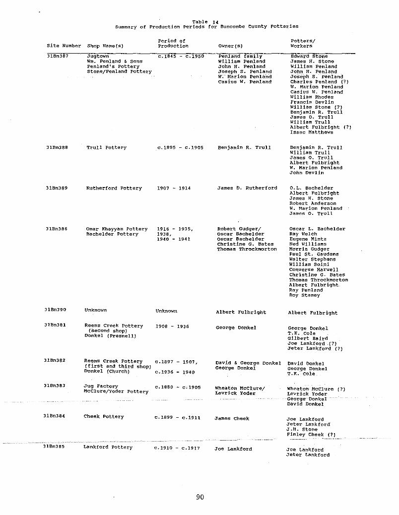
Table 1<1Summary of Production Periods for Buncombe County Potteries
Period ofSite Number Shop Name(s) Production
31Bn387 Jugtown c.1845 - c.1950Wm. Penland & SonsPenland's Potterystone/Penland Pottery
31Bn388 Trull Pottery c.1895 - c.1905
31Bn389 Rutherford pottery 1907 - 1914
Owner(s)
Penland familyWilliam PenlandJohn H. PenlandJoseph S. Penlandw.Marion Penlandcasius W. Penland
Benjamin R. Trull
James D. Rutherford
Potters/Workers
Edward stoneJames H. stoneWilliam PenlandJohn H. PenlandJoseph S;PenlandCharles Penland (?)W. Marion PenlandCas ius W. PenlandWilliam RhodesFrancis DevlinWilliam Stone (?)Benjamin R. TrullJames O. TrullWilliam TrullAlbert FUlbright (?)Issac Matthews
Benjamin R. TrullWilliam TrullJames o. TrullAlbert FulbrightW. Marion PenlandJohn DevlIn
o. L. BachelderAlbert FUlbrightJames H. stoneRobert AndersonW. Marion PenlandJames o. Trull
31Bn386 Omar Khayyam PotteryBachelder Pottery
1916 - 1935,1938,1940 - 1941
Robert Gudger/Oscar BachelderOscar BachelderChristine G. BatesThomas Throckmorton
Oscar L. BachelderRay WelchEugene MintzNed WIlliamsMorris GudgerPaul st. GaudensWalter StephensWilliam SoiniConverse HarwellChristine G. BatesThomas ThrockmortonAlbert FUlbrightRay PenlandRoy stamey
318n390
318n381
318n382
31Bn383
Unknown Unknown
Reems Creek Pottery 1908 - 1936(second shop)
Donkel (Presnell)
Reems Creek Pottery c.1897 - 1907,(first and third shop)Donkel (Church) c.1936 - 1940
Jug Factory c.1880 - c.1905MCClure/Yoder Pottery
Albert Fulbright
George Conkel
David & George DonkelGeorge Donkel
Wheaton MCClure/Levrick Yoder
Albert Fulbright
George DonkelT.R. ColeGilbert BairdJoe Lankford (1)Jeter Lankford (1)
Dav id DonkelGeorge DonkelT.R. Cole
Wheaton McClure (1)Levrick Yoder
-George--OonkelDavid Donkel
31Bn384
31Bn385
Cheek Pottery
Lankford Pottery
c.1899 - c.1911
c.1910 - c.1917
90
James Cheek
Joe Lankford
Joe LankfordJeter LankfordJ.H. stoneFinley Cheek
Joe LankfordJeter Lankford
this site were qualitatively different, however, from those athis other shop, the stone/Penland. This difference may haveresulted from the quality of clays which occur in each separateregion (Candler versus Weaverville areas).
Additional comparative research of paste and clay types between these two pottery locations may reveal more useful information about this observation. The wares produced at the Rutherford site were all albany slipped but made by a team of potters.The obvious replacement of alkaline glazed by slip gl<izeg stoIlewares was a useful observation for recognizing temporal changesbetween and within sites. Analysis of vessel form changes fordifferent potters' wares will require more research than a briefrim inspection can offer. Decorations on the wares were minimalon the sherds recovered through archaeological reconnaissance.Some cobalt accenting over a white slip was noted at the Rutherford site. Several sherds from the McClure/Yoder site weredecorated with incised banding or scallops, a technique commonlyfound on Catawba Valley stonewares.
In describing the physical characteristics of these sites afew observations can be summarized. Only two of the sites werelocated in agricultural fields (TrUll and Rutherford). One sitehad been recently graded away (Donkel - church property). Theremaining seven sites were located in residential areas nearhomesites, all but one of which (the Fulbright site) are stillmaintained. Consequently, these sites were all near major roadways or secondary roads with easy access. Most sites were located near some source of water, such as a spring, creek, or smallbranch, except the McClure/Yoder site in Weaverville. The siteswere situated on first terraces or benches, near bottomlands richwith clay deposits, except for the downtown site ofMcClure/Yoder. It is likely that clay was hauled to this sitefrom some nearby clay deposit, possibly the Reems Creek locationwhich was later purchased by George Donkel.
None of the sites exhibited above-ground evidence of thekiln, shop or other structural features. No distinct wasterpiles were observed, though sherd concentrations were visible insome garden areas. Research questions related to intrasite andintersite patterning could not be fully realized during thistesting project and will, therefore, have to await larger scaleexcavation or investig<ition.
Assessment of. the historical documentation about these sitesformed the third series of research questions. It was importantto understand how this. data set would interface with the archaeological records for each site. Certain potters and their fami~
. lies , -the Donkels,Penlands-,and-Bachelder, . received .considerableattention from other researchers prior to this project (e.g.,Dillingham 1981, Johnston 1974 and 1983, and Zug 1986). Usefulsite-specific information was available from these references.Family histories existed for the Trull, Cheek, Lankford and Yoder
. -----clans--but--it-s-usef-ulness-tearchaeologica-l-site-interpretationwas limited. Family descendants of the potters were interviewedat the Cheek, penland, Trull,and Rutherford sites. Once again,information regarding family history was related but site-specific data was variable, except at the Rutherford site. At this
91

Rutherford site. At this site, Tom Rutherford's recollectionshelped to pinpoint the buried kiln remains. Interestingly, mostinformants interviewed had poor memories of the shape, size, andstyle of the kiln. Wares, shops, and other physical remains fromthe site were better recalled.
The archaeological record for most of these sites was enhanced by supplemental resources which varied considerably inreliability, accuracy, description, and application. Printed andoral information was combined for the most effective researchstrategy. Relevant information was then selected from these twosources which could be applied to archaeological site interpretation in the field. First-hand accounts, old photographs, maps,and land deed records proved the most useful categories of sitedata.
Assessment of Individual site significance
This archaeological and historical survey of Buncombe Countypottery sites has focused on the temporal and spatial aspects ofa cottage industry and its manifestations in the physical andcultural realms. Future research should focus on further exploration of the preliminary information offered in this report.The interrelationships (familial and regional) should be furtherinvestigated to determine what collective strategies set theseceramic craftsmen apart from others in their social milieu.
Historical information and archaeological data collectedduring the survey indicated business and kinship relationshipsexisted between several of the Buncombe County potteries. Someof these interrelationships were reflected in similarities ofkiln designs used, wares, forms and glazes produced, and decorative treatments employed. Other questions involving resourcecompetition should be explored. For example, how did the competition for wood between the potters and the lumber companieseffect market and production strategies? What other homeproduced foodstuffs or commodities (such as honey or moonshine)were sold in tandem with the pottery to increase their market?And finally, how did the ceramic craftsmen sell their wares, bybarter or cash exchange, and how did this relate to their statusin the community?
Following the National Register eligibility criteria, specifically C. and D., these pottery manufactory sites embodydistinctive characteristics of a particular cottage industrydating to the nineteenth century and early twentieth century.They represent the locations of activities performed by mastercraftsmen and their apprentices in rural;-agrarian"-'baSed dommunities. The kiln structures (or remnants of these structures)associated with these ceramic manufactories also represent veryspecialized building design and construction. The ceramicsproduced at these pottery sites, remains of which have beenarchaeologically-retrieved i - --also-possess artistic qualities foundonly among the utilitarian folk potters of the southeasternunited states. In addition, these pottery sites, collectivelyand individually, represent significant components of BuncombeCounty history during the pre-industrial decades.
92
Four categories of observation and evaluation are presentedwhich form the basis for assessing site significance and eligibility to the National Register of Historic Places. Table 15provides a summary of the physical evidence for each site. Thesecategories include the nature of ground disturbance, kiln integrity, presence/absence of waster piles, and overall stratigraphicintegrity. The results of this study, achieved through historical and archaeologial corroboration, indicate that five of theten sites researched in. Buncombe County should receive furtherinvestigations. Two of these five discussed, the McClure/Yoderand FUlbright sites, will require additional research to determine more about their subsurface integrity or possible remains.
structural remains or significant features were discoveredat three sites, the Cheek, the Rutherford, and the Donkel (Presnell) locations. Of these, the Rutherford kiln remains appearto be the least disturbed. Recommendations for further researchat these sites is strongly urged. Individually, these threesites could be considered eligible for the National Register.Disturbances of cultural and natural origin have been discussedfor each site which clearly effect their individual eligibilitypotential. Collectively, however, the sites offer potential as aunique historic district which reflect chronological and stylistic ingredients of Buncombe County's folk pottery tradition~
In summary, the sites examined during this survey form 'animportant non-renewable cultural resource in Buncombe Countyheritage. Furthermore, these sites offer the opportunity tocompare and contrast the specific attributes of this cottageindustry on a state-wide and regional scale. Preliminary observations of how Buncombe County potteries compare to those in theCatawba Valley and central Piedmont regions of North Carolina andthe pottery regions of South Carolina have been offered in thisreport. Recommendations for a National Register nomination aremade to include all the sites researched during this survey.
National Register Significance Recommendations
The stone/Penland site (31Bn387) is the earliest documentedstoneware pottery manUfactory in the county as well as the mostcontinuously operated (see Table 14). Although the kiln appearsto have been destroyed through house construction, other areas ofthe site offer further archaeological research potential. Sherdconcentrations in the area of Wallace's garden suggest an abundance of waster debris across this portion of the site. Additional laboratory analysis is also recommended for artifactsrecovered from this site; .. Individually; ··thissitemay not beeligible for the National Register but should be included as acontributing element for a historic district nomination.
The Trull site (31Bn388) has been extensively cultivatedover the seven decades since this shop ceased operation. Archaeological·testingdidnot·reveal·····intact·structuralremains·;··Artifacts recovered from excavations and surface collections,however, should yield important information regarding this pottery operation. Similarities of wares, glazes, and kiln furniture were noted between this site, the stone/Penland site, and
93
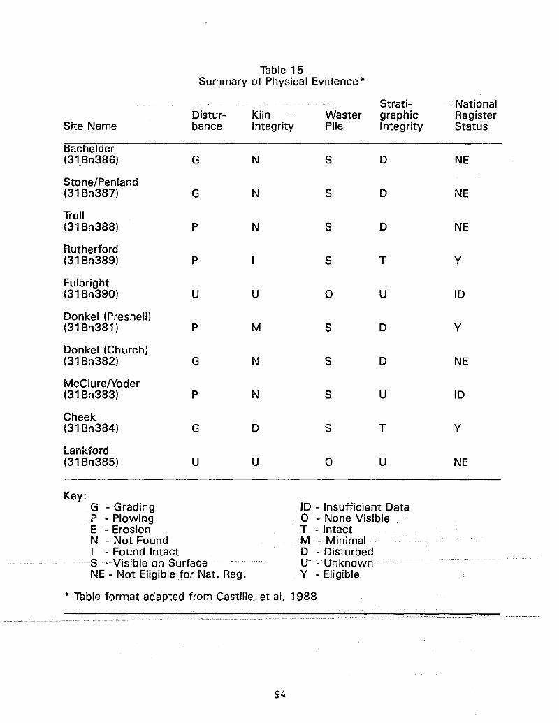
Table 15Summary of Physical Evidence*
Strati- NationalDistur- Kiln Waster graphic Register
Site Name bance Integrity Pile Integrity Status
Bachelder(31 Bn386) G N S D NE
Stone/Penland(31 Bn387) G N S D NE
Trull(31 Bn388) P N S D NE
Rutherford(31 Bn389) P S T Y
Fulbright(31 Bn390) U U 0 U ID
Donkel (Presnell)(31 Bn381) P M S D Y
Donkel (Church)(31 Bn382) G N S D NE
McClureIYoder(31 Bn383) P N S U ID
Cheek(31 Bn384) G D S T Y
Lankford(31 Bn385) U U 0 U NE
Key:G - Grading ID - Insufficient DataP - Plowing 0 - None VisibleE - Erosion T - IntactN - Not Found M - MinimalI - Found Intact D - DisturbedS • Visible on Surface U cUnknOwhNE - Not Eligible for Nat. Reg. Y - Eligible
* Table format adapted from Castille, et ai, 1988
94

the Rutherford site. For this reason, further comparative analysis is recommended for the Trull site artifacts. This siteshould also be considered as an important. contributing element tothe district nomination.
Test excavations at the Rutherford site (31Bn389) exposedthe intact subsurface remains of a rectangular kiln. It alsoappears to retain the greatest subsurface integrity of all sitessurveyed during this project. A more thorough archaeologicalexcavation is reCommended for this site. Historical recordsindicated that this pottery operated as a factory with mechanizedequipment and a large labor force, and mass-produced (mold~made)
items. Additional analysis of the artifacts (sherds and kilnfurniture) found here could provide important comparative information useful for site interpretation. This site is consideredindividually eligible for inclusion to the National Register.
The ceramics made at Bachelder's Omar Khayyam Pottery(31Bn386) were somewhat different from those produced at theother, more traditional Buncombe County potteries. The site(31Bn386) also contained an abundant variety of kiln furniture.Further analysis of these artifacts could reveal additionalinformation about the transition from utilitarian wares to artforms produced at the site. Extensive historical documentationhas already been compiled about O.L. Bachelder and his OmarKhayyam Pottery by Pat Johnston (1974 and 1983). Archaeologically, however, only a small portion of the site appeared to beintact. Nonetheless, the site should be included as an importantcomponent to a district nomination.
The Fulbright site (31Bn390) should be further explored toconclusively determine if a kiln and pottery shop existed at thisresidential location. Insufficient data prohibit an assessmentof National Register significance at this time.
Test excavations at the Donkel (Presnell) site (31Bn381)revealed a burned clay feature and architectural debris associated with kiln remains. The site represents nearly 30 years ofcontinuous pottery production by George Donkel. Portions of thesite, in the garden and yard areas, appear to be partially intacteven though plowing has· disturbed the upper strata. Earlyphotographic documentation of the pottery operation by WilliamBarnhill in 1917 provides a valuable supplementary data sourCefor further research at this site. This site is consideredindividually eligible for nomination.to·the National Register.
The site of Donkels' first and>third pottery workshops,located on the.church property, {31Bn382),hasbeennearlyde"stroyed. Several feet of topsoil have been removed and onlyscantevidenceafpotteryactivitywasrecoveredduringtesting;Individually,.thi,ssiteis not considered eligible for inclusionto the Register, but should be included as a contributing elementin a historic district nomination.
Hundreds of artifacts were surface.collected in the garden.. . .. . ·areaatthe··McClcure/YcoderSite·(31·Bn383jc.·Unf·ortunately;subsur-
face testing in this area was temporarily prohibited because ofexisting crops. The artifacts recovered during testing andsurface reconnaissance suggest the possible existence of kilnremains at the site. At present, the site appears to represent
95
the earliest pottery operation documented for the Weavervillearea. Additional archaeological and historical research isstrongly recommended for this little-known site. At this time,data are insufficient to determine its National Register significance but it could still be included within a district nomination.
The Cheek site (31Bn384) is considered eligible for nomination to the Register as an individually significant site. Testexcavations revealed the intact subsurface remains of a brickpottery kiln along with dense waster deposits. Subsurface integrity appeared to be relatively good in the yard area where thekiln remains were discovered. Several nearly whole, reconstructable, pottery jars made by J.H. Stone were uncovered near thekiln foundation. Further archaeological work is crucial toconclusively determine the shape and style of this kiln. Thefact that Stone (from Candler) and the Lankfords (from stockville) worked here as potters could be historically significantin documenting how and to what extent potters from the two separate regions exchanged ideas about production, style, composition, or other "trade secrets."
No archaeological testing was conducted at the Lankford Site(31Bn385) because of its severely altered condition due to modernlandscaping and house construction. This site should be revisited and additional historical and archaeological data gathered formaking an individual eligibility determination. If a thematicnomination is approved for the district, this site should beincluded.
Conclusions
This survey of archaeological and historical research conducted at pottery sites located within two distinct regions ofBuncombe County has focused on the heritage of the potters, thewares they turned and the kilns they burned. From the beginningof frontier settlement in North Carolina up until the twentiethcentury, pottery shops, or "jugtowns", have concentrated near theessential clay resources. In Buncombe county, however, an abundance of fine clays, wood for fuel, rapidly expanding popUlations, an economy dominated by small, self-sufficient farms, anda relative isolation from outside markets created ideal conditions for the traditional folk potters in the nineteenth andtwentieth centuries. As demonstrated by this brief examinationofa very specialized cottage indUstry, BUncolllbe Colirityoecallle acultural hearth to settlers from various ethnic and regionalorigins. The tenacity of the folk potters' blended culturaltraditions, and the material manifestations of those traditions,will remain the sUbject of continued historical research and.archaeological explorations. Future _.. research on Buncombe-C01.lrity ..potteries should include efforts to locate those sites referencedin the historical documents but are presently unknown.
96
Asheville1941
REFERENCES
citizens TimesOmar Khayyam Pottery will Open Again Soon, AshevilleCitizens Times, March 9, 1941.
Bailey, Moulton, et al.1977 Interim Soil Survey of Buncombe county. North Carolina.
United States Department of AgricUlture, Soil ConservationService, Asheville.
Brackner,1981
JoeyThe WilsonUniversity
Potteries. Unpublished masters thesis,of Texas, Austin.
Bridges, Daisy Wade, editor1980 Potters of the Catawba Valley. Journal of Studies of
the Ceramic circle of Charlotte. Volume IV. MintMuseum, Charlotte.
Burrison,1989
JohnThe Story of Georgia Folk pottery. In Georgia Clay:pottery of the Folk Tradition. Exhibition catalogpUblished by the Museum of Arts and Sciences, Macon,Georgia.
Carnes, Linda F.1986 Appendix A: The Potters of Alamance County. In
Alamance county Archaeological Survey Project,Alamance County, North Carolina, by Jane McManus andAnn Long. published by the Research Laboratories ofAnthropology, University of North Carolina, ChapelHill.
1987 Investigating the Transition of Earthenware to Stoneware. Pottery Production in Nineteenth Century NorthCarolina: .An Interdisciplinary Study. Unpublisheddoctoral proposal in Department of Anthropology,University of North Carolina, Chapel Hill.
Castille,'1988
George, et al."Archaeological" Survey of Alkaline-Glazed Pottery Kilnsite in Old Edgefield District. South Carolina.McKissick Museum, University of SouthCarolina, Columbia, South Carolina.
. ,ConwaYi Bob anGi·Ed Gilreath1974 Traditional Pottery of North Carolina. Exhibition
catalog pUblished by the Mountaineer, Waynesville,North Carolina.
97
Dickens, Roy S.1978 Cherokee Prehistory: The Pisgah Phase of the Appal
achian summit Region. University ofTennessee Press, Knoxville, Tennessee.
Dillingham, Deena1981 Reems Creek Pottery Works. Unpublished manuscript
on file at Mars Hill College, Mars Hill, NorthCarolina.
Eaton, Allen H.1937 Handicrafts of the Southern Highlands. Dover
Publications, New York, New York.
Enka Voice1938 Jugtown. Enka Voice, Volume 9,
Employees of the American EnkaNorth Carolina.
Number 7.Corporation, Enka,
Fenneman,1938
N.H.Physiography of Eastern United states. MCGraw-Hill,New York, New York.
Greer, Georgeanna H.1981 American Stonewares, The Art and Craft of utilitarian
Potters. Schiffer PUblishing, Ltd., Eaton, Pennsylvania.
Johnston,1983
Pat H. and Daisy Wade BridgesO.L. Bachelder and his Omar Khayyam Pottery. Journalof Studies of the Ceramic Circle of Charlotte, Volume5. Mint Museum, Charlotte, North Carolina.
Johnston,1974
Pat H., editorBachelder and stephen. Antiques Journal,Issue. Asheville, North Carolina.
September
Keel, Bennie1976 Cherokee Archaeology: A study of the Appalachian
summit. University of Tennessee Press, Knoxville,Tennessee.
Landreth,1985
GeraldArchaeological Investigations at the Trapp-ChandlerPottery, Kirksey; South Carolina; UnpUblished mastersthesis, University of Idaho.
Leftwich,1989
RodneyUnpublishedPotteries.
notes and photographs of Buncombe CountyPrivate· collection.
98
Michalek,1969
Daniel D.Fanlike Features and Related Periglacial Phenomenaof the Southern Blue Ridge. Unpublished doctoralthesis, Department of Geology, university of NorthCarolina, Chapel Hill, North Carolina.
North Carolina Clipping File1979 A History of Asheville and Buncombe county. Paper
print from microfilm of Collected North CarolinaNewspaper Clippings, University of North CarolinaLibrary, Chapel Hill.
Pickens, Nell1962 Dry Ridge. Some of Its History. Some of Its people.
Miller Printing company, Asheville, North Carolina.
Purrington, Burton L.1983 Ancient Mountaineers: An Overview of the Prehistoric
Archaeology of North Carolina's Western MountainRegion. In The Prehistory of North Carolina:An Archaeological Symposium, edited by Mark Mathisand Jeffrey Crow. North Carolina Department ofCultural Resources, Division of Archives andHistory, Raleigh.
Roberts, Minnie Brankn.d. Unpublished memoirs maintained by her daughter,
Mrs. Blanche Robertson. Private collection.
Sharpe, Bill, editor1948 North Carolina: A Description of counties. Warren
Publishing Company, Raleigh, North Carolina.
Smith, Samuel and Steve Rogers1979 A Survey of Historic Pottery Making in Tennessee.
Division of Archaeology, Tennessee Department ofConservation, Nashville.
sweezy, Nancy1984 Raised in clay: The Southern Potterv Tradition.
Smithsonian Institution Press, Washington, D.C.
Zug, Charles G., III1981 The Traditional Pottery Of North Carolina. Ackland
Art MuseumiUniversityofNorthCarolinai Chapel Hill;
1986 Turners and Burners:Carolina. university-Chapel Hill.
99
The Folk Potters of Northof North Carolina Press,

MAPS:1859 Map of Asheville and Region of western North Carolina
by Colton.1883 Map of western North Carolina by Dr. W.C. Kerr,
State Geologist.1901 U.S.G.S. 15-minute Asheville Quad. Reprinted 1921.1903 Map of Asheville and Surrounding Environs by
Taylor Rogers.
COUNTY RECORDS:1850, 1860, 1870, 1880, 1900, and 1910 Census RecordsBuncombe County Registry of Deed BooksBuncombe County Court MinutesBuncombe County Book of wills
100