THE GLACIAL. GEOLOGY OF VERMONT...tt • OFFiCE OF THE STATE GEOLOGIST Rom • H THE GLACIAL....
65
tt • OFFiCE OF THE STATE GEOLOGIST Rom • H THE GLACIAL. GEOLOGY OF VERMONT By DAVID P. STEWART • VERMONT GEOLOGICAL SURVEY CHARLES G. DOLL, State Geologist S Published by VERMONT DEVELOPMENT DEPARTMENT MONTPthAER, VERMONT BULLETIN No. 19 • 1961
Transcript of THE GLACIAL. GEOLOGY OF VERMONT...tt • OFFiCE OF THE STATE GEOLOGIST Rom • H THE GLACIAL....

tt • OFFiCE OF THE STATE GEOLOGIST Rom
• H
THE GLACIAL. GEOLOGY OF
VERMONT
By
DAVID P. STEWART
• VERMONT GEOLOGICAL SURVEY CHARLES G. DOLL, State Geologist
S Published by
VERMONT DEVELOPMENT DEPARTMENT
MONTPthAER, VERMONT
BULLETIN No. 19 • 1961

TABLE OF CONTENTS -
PAGE INTRODUCTION
The Hitchcock Concept of the Great Ice Age ........ 7 The Status of Previous Investigations of the Surface Material: 10 The Survey of the Surface Deposits now in Progress ........ 11 The Source of the Material for this Report ........... 12 Acknowledgements . ................... 12
THE PLEISTOCENE EPOCH IN NORTH AMERICA ......... 14 Subdivisions of the Pleistocene Epoch ........... 14 Subdivisions of the Wisconsin Stage . ......... . . 15 Radiocarbon Dating ..................... 17
THE GLACIAL SEQUENCE IN NEW ENGLAND ............ 19 THE GLACIATION OF VERMONT ................. 22
Glacial Advance and Retreat ................ 23 Glacial Advance .over Rugged Topography ......... 23 Deglaciation in Regions of Bold Relief ........... 25 Glacial Erosion : ..................... 26 Glacial Materials ..................... 30
Till ........................... 31. Mantle Material ................ '. . . 34 Glacio-fluvial Deposits .................. 36
Till Sheets and.the Age of the Drift .............. 39 THE GLACIATION OF THE CONNECTICUT. RIVER VALLEY AND ITS TRIBUTARIES
The Glaciation of the Connecticut Valley Proper ...... 46 Glacial Waning in the Valley ................. 47 The Glaciation of the Connecticut River Tributaries . - . 53 Glacial Lakes of the Connecticut Valley .......... 54 Lake Sediments of the Tributary Valleys ............ 57 Evidence of Ice Readvance in the Connecticut Valley . 61
THE GLACIATION OF THE VERMONT PIEDMONT ... ... ...• 67 Piedmont Lakes of Glacial Origin .............. 74 Post Glacial Lakes of the Piedmont .............. 76
THE GLACIATION- OF THE NORTHEASTERN HIGHLANDS ...... 77 THE GLACIATION OF THE GREEN MOUNTAINS ......... 78
Glacial Drift in the Green Mountains ............ 80 Glacial Erosion in the Green Mountains
: ........ 80 Ice Waning in the Green Mountains ............ 82

PAGE TABLE PAGE
THE GIcIATIoN OF THE CHAMPLAIN LOWLAND ........ 83 I. Subdivisions of the Pleistocene Epoch .......... 16
Glacial Erosion and Deposition ............... 84. II. The Subdivisions of the Wisconsin Stage . ...... 17
Lake Vermont ............. . -. . . .. . . 85 . The Champlain Sea .................... 86 . PLATE . PAGE Lacustrine Deposits of the Winooski, Stowe and Dog River . I - General classification and distribution of the
Valleys ....................... 88 surface material mapped 1956-1959 . . (In pocket) Possible Correlation of the Lake Levels of the Winooski, . . . II . The direction of ice movement . . . . (In pocket)
Dog River. and Stowe Valleys ............. 92 . 111-Figure 1. Glacial striae on the crystalline bedrock. 27
Proposed Correlation and Naming of the Lake Stages . . . 97 . Figure 2. Clayey bouldery till bank 100 feet high 28
THE GLACIAL GEOLOGY OF THE BURLINGTON AREA ...... 100 TV-Figure L Kame gravel showing ice-contact structures 30 The Glacial Sequence in the Champlain Basin ....... 101 Figure 2. Normal fault. Ice-contact structure . . . ,. 31
The Earliest Recorded Glaciation .............. 102 . V-Figure 1. Mantle material showing angular boulders . 33
Evidence of an Early Interstadial Lake .......... 102 . Figure 2. Mantle material covering delta built into
The Last Glaciation in the Burlington Area ........ 103 glacial lake ................. 34
Lake Vermont ........ 105 VI-Figure 1. Hillside covered by surface mantle ...... 35
The Highest Lake Vermont-The Quaker Springs Stage 105 . . Figure 2. Small terraces formed by surface mantle. . 36
The Coveville Lake Stage ............... 107 . . Vu-Figure 1. Kamé terrace at White River Junction . . 38
The Fort Ann Lake Stage ............... 1Q8 . Figure 2. Kame terrace 150 feet high ........ 39
Pre-Champlain Sea Erosion ................ 110 . VIlI-Figure 1. Ice-contact and slumping structures ..... 51
The Champlain Sea .................... 110 . Figure 2. Faulting in lake sediments .......... 52
The Higiiest Marine Shore ............... 110 . TX-Figure 1. . Varved clay containing rounded cobbles . . 59
The Withdrawal of the Champlain Sea . ......... 111 Figure 2. Level surface of the kame terrace ....... 60 The Monkton Quartzite Boulder Train ........... 111 X-Figure I. Glacial striae and polish on crystall me rock. . 69
The Essex Esker ...................... 112 Figure 2. Sheeting of granite intrusion ........ 70
THE GLACIATION OF THE VERMONT VALLEY .......... 112 XI-Figure 1. The rolling rock of Braintree ......... 72
THE GLACIATION OF THE TACONIc MOUNTAINS .......... 113 .Figure 2. Kame terrace gravel in Gunner's Brook. . . 73
BIBLIOGRAPHY ........................ 114 XII-Figure 1. Gravel in kame terrace ........... 74 Figure 2. Ice-contact structure-of kame terrace . . . 75
Illustrations . . XIII-Figure 1. Gravel in kame terrace on Barnes Hill ..... . 88- FIGURE .. PAGE - Figure 2. Bedding of laminated lacustrine silt . . . . 89 1. Index map showing area coveted and quadrangles mapped by XIV-Figure 1. Beach gravel ............... 93
Surface Geology Survey 1956-1959 ............. 13 . . Figure 2. Beach gravel terrace . . . .. . . . . . . .. 94 2. Index map showing the Physiographic Subdivisions of Vermont. 45 XV-Figure 1. Cross-bedding in lacustrine sand ....... 96 3. Generalized cross section showing the sediments along the Figure 2. Cut and fill in sandy lake sediments. . . . 97
Connecticut River in the vicinity of Canoe Brook . . . . . . . 63 . XVI-Figure 1. Topset and foreset beds of delta . . . .. . . . 98 4. Generalized cross section showing the sediments along the . Figure 2. Varved clay covered by lacustrine sand . . 99
Third Branch of the White River one mile south of Randolph. . 65 XVII-Figure 1. Gillett Notch .............. - 103
5. Generalized cross section showing lacustrine sediments in the . Figure 2. Poorly drained upland of the northeast high- Dog River valley two miles north of Riverton . . . . . . 91 lands ................... 104

• PLATE PAGE
XVIII—Figure 1. Tw6iills exposed in stream valley . . . . . . 108 Figure 2. Glacial erratic embedded in varved lacustrine
clay .............. .... 109. -
THE GLACIAL GEOLOGY OF VERMONT
DAVID P. STEWART
INTRODUCTION
The most recent geologic epoch, the Pleistocene, widely known to the non-geologist as the Great Ice Age, is everywhere manifested on the surface in the State of Vermont.' During this short interval of amillion years, or less, the state, as well as the whole of New England, was sub-jected to repeated episodes of continental glaciation. The glaciers formed far to the north and as they advanced southward )ver the area the weãthered mantle was removed from the bedrock and the topographic expressions of the mountains, hills and valleys were accnrdingly modified. These advancing masses of ice also scooped out basins of various sizes that were later to be filled with water, forming lakes. As the ice retreated to the north, a new mantle was spread over the surfne of the land by the melting ice and the resulting meitwater streanm. After the last
- glacier retreated, the rock structure was the same as it had been, and the major aspects .of the topography were only slightly changed; but the local details of the surface expression were greatly modified and the surface material was completely different. As Vermont is predominantly an agricultural and recreational state it is quite obvious that the glacially formed surface features, both erosional and depositional, have a direct influence on the present culturalaspects of the region.
The Hitchcock Concept of the Great Ice Age
It seems appropriate, since this report is published as a part of the Vermont Hitchcock Jubilee celebration, that this manuscript should begin with a short discussion regarding Professor Edward Hitchcock's concept of the Glacial Epoch and.his classification of the drift of Ver-mont and New England. These concepts are most important because they were accepted by many of Professor Hitchcock's colleagues and were not abandoned by many New England geologists until after the turn of the presentcentury. It is a fact that many of the misconceptions of his writings hindered the correct interpretation of the glacial material for over forty years. -
Jacobs (1946 p. 22) described Hitchcock as a Neptunist because of his belief of a tiniversal ocean. He was, however, more than a Neptunist
- 7.

dC
)
aG
)-n
G)
4G
)0=
E..
04
Cd U
) V
.a)+
Cd
•C
d .....
O
QC
d
0 000
Cd
0
C) C)
,
00
-cd
C)b•C
)
V
•-
Cd
C
-
0
o
• —
..Cd
O
C).
Cd
! C
)cC
).o
Cd
. C)
C)
.—
C\
)-
C)
:
Cd.
-dC
)(1)
0
E
U)
V
•- +
2 C
) b
C)
Cd
0
-.a) Q
C)
C) Cd
.9 V
C)
Cd Q
~ C
d-
C)
Cd E
) )
(I) U
)C
) Cd
r. cfj
Cd
0U
)C
d
Cd
0
C)U
) 0 C
d.
Cd
Cd
U)
Oc
2 C
d,
Cd C)
CdV
Cd
U)
0
)- C
)-".
U1U
U)
j!C)I''
5C
)
C) C)
1p E
0U
).
. C
)gC
)
Cd
C)C
?
U)
Cd Cd
V
Cd .C
dE
0V
.C
) V
—
-E D
V
V
0
Q
8 .Z
C
)+
-h
Cd Cd
0C
)
4 U
)4Q
'd
Cd
Cd Q
0Cd
0C
).0
C) C
) 0
.
b
o.
00
0
C) 0
0
r.C
dU
)
t
o
Cd
V-
C) •E
o $- Cd
Z
2
{fl 0
.
0
0
80
8
04
0C)
Cd
-
Cd ,
•o
U)
~-D
Cd
'
r. 8
Cd
2
:
QC
)r.
cd 0C
).d
--35
Cd
E
° flU
) C
"
U)
.9 Cd
8 oZ
U
) —
0C
d~
u

C!. C
aC
a(a
a
. a)
0
•-' -
'
h
C) .0
Ca
0
ct
o C-
(a
ll)
Ca C
a a)
-' 0
C) 0
0_
_-
•' C)
(a
'O
0,
4
Ca .0
0
.0
0
'0.C
a
C-.
.0
. 4-,..
41 '-'
a) 4-,
' a)0
a)
a) 0
-0
E
En 0
C
aC
)
In
C) 00
E
Lz (a 4-
0
(a
• ?-.. 0
• )
2
b
00
Q
.ca
41
()
) C
j 0 )
Q
,.. 0
cd 0
Cl) Cl)
Cl) —
(a
a)_
0
G) •fli
. •
Cl)
a)C
U)
;Lh
P
' 0
cd
0
Ca En
•I:
a) a) cd
in W
b Q
0)C
.4
a)
a)04)00'f
l
O
Q
a) a) bl)
ol5
.o Ca
00 C
a C
acd
0
0
a) 0
Ca
0(a
0
Ca
cd
"
s-
0 0
'
0
Ca a)-00
r. Ca
a)4
C) (a
0 C
) C)
Cl) a)
Ca 0 a).•Q
Ca
o-0.
a) (a
(aa)
0 C
a
(a ,o
Ca
C) -
30
o
o
C)
++
-4-'
C) C
C 'O
a)
C
0 v
C
)- C
4,0
a)•
C- +
'Ca
a)
.-
'. C)
o
.o
-
0+
o,- W
i 0
1.
U
C
0
'0
a)0
(a a) d
0co
Cd
Ca ••
0.0
a)
a)d
Ca'd
a)
o•b
0
0
2 0.0
a)
+E
Ca
(aC
a Ca
4-'2
'
a) '4
-'
4- u
(a
"
.E a)
Ca ~
' (a
) 'j
(a
'-'C
a .0
.0
-I Ca
J 4
-' .
, a)
0
Ca
EC
a
'd
0
-' En
4-'
Q,
C) 0
4-'
bl) Cd
b H
.- 00 0
too
Ita
)
Ca Ca
.54C
a 0
0
•000
Ca
C
Toa
' 9
-'4-0
a) 0
C
l)Ca
oC
a0
0
41
0
0
0
C-.
0 0
C
a Ca
00a
)E
'0
Ca.0
Ca
..
C- 0
•t! •
.)4 •
C
0
4-'"C
aO
-
Ca 0s
a).-
'•
C
Ca
I 000
0
a)
0 C
)
(a0
• Ca
.
.t '0
bO
'6
C) (a
C-.
C) cu
• 0
0'
"4-'
•-
a)a
)
C) C
)=1
Ca 0
.0
(a 0
.
C) 0 0
' 0
- J
' (a
Ca
C C
)'-' 6
Ca
cu E
- I
4-'
+'C
a) 0
0
. 0
0•
0
4-' '0
0
5
0 a
) 0'C
a
_a
)•C
-
::'--t;
(a.0
.-.4
., 0
4a
)
C

in Vermont and the surface map produced will also be the first. In addi-tion to the map, however, the objectives of this project include the collecting of data that will add to the knowledge of the glacial stratig-raphy and glacial lakes sequence, thereby allowing a more complete interpretation of the Pleistocene history.
The survey, as already stated, is still in progress and to date surface maps of eleven quadrangles have been made. These quadrangles com-prise approximately twenty percent of , the total in the state (Figure 1). As can be seen, the survey has not yet covered a large enough area to give a very complete answer to most of the problems that are still un-solved (Plate I).
The Source of the - Material for thisReport It would be advantageous if, the writer of this report could record the
details of the glacial materials and structures in all parts of the state from the point of view of one who had studied each section. But, as stated above, the present survey has been in progress only four years and, as yet, only a small portion of the state has been surveyed. The
• data collected thus far during the study will, of course, be utilized in this report but it will also be necessary to rely heavily on the scanty
• literature concerning the areas that have not been recently covered. As a part of the research -for the preparation of this manuscript, a
literature survey was made covering studies of the glacial geology of - Vermont and adjacent areas of New York and New England since 1861. This literature search -resulted in the bibliography that appears at the - end of this publication. In spite of the lengthy list of titles in the bibli- - ography, the pertinent information concerning many areas is quite
• limited. - The coverage that this report can give these.areas is of necessity quite brief and of only a general nature. One of the objectives of the - present survey - is to produce a more detailed thesis on the Pleistocene history of Vermont when time has allowed a more complete coverage.
It is therefore the purpose of this report to review the general aspects of the glacial geology as it has been recorded in the literature. These concepts will be amplified and modified when it becomes possible to do so from the significant findings of the present survey. Thus, this paper is to acquaint the reader with the Pleistocene history of the State of Vermont to the extent that information is available at this date.
Achnowledgements The surfaáe survey, now in progress, is sponspred jointly by the Ver-
mont Geological Survey and the Vermont Highway Department. The
12
Cr
0
1> L<wSADFORD ,
>-
RVCR
t,J
z
• SCALE A 500.000
/M AS S A C H U S E-T T S
Figure 1. Index map showing area covered and quadrangles mapped by Surface Geology Survey 1956-1959.
13

work is being carried out under the direct supervision of J)r. Charles G. Doll, State Geologist. The writer was ably assisted in the field during the 1956 and 1957 seasons by Lawrence D. Perry. During the summer of 1958 and a part of 1959, Thomas H. Hawisher was field assistant and Hugo Thomas also assisted during a part of the 1959 field season.
The literature search, mentioned above, was generously supported by Miami University, Oxford, Ohio in the form of graduate research assistantships over a period of two years. J. Douglas Glaeser prepared the bibliography during the 1957-1958 school year. During the next year (19581959), Thomas H. Hawisher (who was also a field assistant) assisted in the tedious task of locating, obtaining, reviewing and evalu-ating the three hundred and fifty titles contained in the original bibli-ography. Miami University also supplied funds necessary for the draft-ing of the maps and diagrams contained in this manuscript. -
The writer gratefully acknowledges the valuable assistance of Dr. Paul MacC lintock of Princeton University and Dr. Raymond E. Janssen of Marshall College. Dr. MacClinock visited the writer in the field and read the rnanuscript. Dr. Janssen also read the manuscript. Their corririents, criticisms and suggestions have been most helpful in the preparation of this report.
THE PLEISTOCENE E1OCH IN NORTh AMERICA The Pleistocene Epoch of the Quaternary , Period (Richards, 1953,
p. 351) in North America. dates from the climatic extreme that allowed the accumulation of snow and ice in such great proportions as to cause the formation of continental glaciers. Paieontological research and the study of marine sediments may, in the near future, supply a more ex-plicit basis for marking the beginning of this glacial age, but at the present time the climatic factor seems to be the most reliable. In respect to the marking of the end of this epoch, it is not yet possible to ascer-tain that it has indeed come to an end. The last continental glaciers retreated from North America less than 10,000 years ago, and since the interglacial stages were of much longer duration, it is quite possible that the present is merely an interglacial stage of the Great Ice Age or even an interval Of deglaciation of the last glacial episode.
Subdivisions of the Pleistocene Epoch • Basically, the Pleistocene Epoch is a four unit interval in geologic history, represented by four episodes of glaciation. It is estimated that the first ice advance, at the. beginning of the Nebraskan Stage, started
14
about one million years ago. The Nebraskan was followed by three succeeding glacial maxima which have been named the Kansan, Illinoiãn and Wisconsin (Table .1). During each of these stages, the ice formed far to the north, probably in the mountains of northeastern North America (Flint, 1952), and the ice moved outward in all directions. At one time or another during this short epoch, the whole of the northern and portions of the central regions of the North American continent were covered by continental ice sheets. In the eastern and midwestern sections of the United States the southern limits of the ice'invasions extended at least as far south as the islands off the coast• of New England, into northern New Jersey and Pennsylvania and to the preèent Ohio and Missouri rivers. Each ice advance was a slow, spreading movement, and after the glaciers had advanced to their terminal positions, the with-
• drawal'was also a generally slow retreat. After each ice retreat an interval of deglaciation followed during which
time temperatures rose again, and the climate approximated that of the, present time. These periods of ice retreat, the interglacial stages, have been' designated the Aftonian, Yarmouth, Sangamon, and the in-terval since the retreat of the last glaciers which this report prefers to call the post-Cochrane (Table I). Although it is true that the ice advanes and retreats progressed quite slowly in the ordinary concept of time, geologically speaking, the Pleistocene Epoch was a very short span and the glacial history is a record of four ice advances and retreats in very rapid succession. -
SuMivisions of the Wisconsin Stage
Due to the recentness of the Wisconsin glacial' invasions and because the deposits of this stage have not been overridden by subsequent ice sheets, it has been possible to divide it into several subdivisions. For many years it was believed that this stage was represented by four, and only four, distinct'till sheets, and it was therefore subdivided into four substages. These were designated (from oldest to youngest) the Iowan, Tazewell,. Cary and Mankato. More recent studies, however, have es-tablished the fact that there were ,more than four maxima (substages) and, at the present time, seven substages are recognized in the - Wisconsin stratigraphy (Hough, 1959) (Table II).
The above mentioned - original four substages were, proposed by Leighton in 1933. These were well. accepted and were in general use shortly after they were 'proposed. In 1943, however, Thwaites identified a till sheet, which he called the Valders, that he believed to represent a
15

TABLE I.
SUBDIVISIONS OF THE PLEISTOCENE EPOCH
Post Cochrane Wisconsin Stage
Sangamon Interglacial Illinoian Stage
Yaouth Interg1ia1 'Kansan Stage
Mthan Intarglacini Nebraskan Stage
fifth substage. Antevs (1945), however, considered this drift as the same age as Leighton's Mankato. Except for the short period during which there was debate concerning the Mankàto and Valders, the Leighton proposal of 1933 was used as the basis for Wisconsin stratigiuphic cor-relation for almost a quarter of a century. In 1950, Leighton and Willman recognized a drift which they believed to be younger than the Iowan and this drift has since been mapped by Shaffer (1956) and is now known as the Farmdale. In 1957, Elson published the results of his studies of the Agassiz Lake basin. In the course of his studies he traced the Valders and the Mankato drifts across the basin and established the fact that they were of different age; the Valders being the younger. The Cochrane was recognized in Canada and described by Karlstrom (1956).
Like the glacial stages, the substages were also separated by times of deglaciation called intervals. These, in general, have not been as well delineated and defined as the interglacial stages. The intervals are usu-ally simply named the Farmdale-Iowan interval for the time between the Farmdale and the Iowan; the lowan-Tazewell interval between the Iowan and Tazewell substages, etc. (Table II). An exception to this system of naming is the Two Creeks interval between the Mankato and the Valders.
The most significant Wisconsin interstadial, so far as this report is concerned, is that separating the Mankato and the Valders, the Two Creeks interval, This particular interval is important because of the forest beds exposed near Manitowac, Wisconsin, which have been dated by the C14 method as' 11,400 years before the present. Before the sep-aration of the Mankato and the Valders (Elson, 1957) the Two Creeks interval was believed to separate the Cary and Mankato.
Hough (1959) in his recent compilation of data on the glacial history of the midwest, particularly the Great Lakes'region, has proposed three
16
TABLE II.
THE SUBDIVISIONS OF THE WISCONSIN STAGE
Post Cochrane Cochrane substage
Valders-Cochrane interval Valders substage',
Two Creeks interval Mankato substage
Ca-Mato interval Cary substage
'Tazewell-ry interval Tazeell substage - -
- Iowan-TazeweU 'interval Iowan substage
- Fadale-Iowan interval Farmdale substage
new names for the substages of the Wisconsin. These are: the Shelby-ville-lowan for the Iowan, which he believes may be more correctly correlated with the early Tazewell; the Bloomington for the substage that has been called the Tazewell; and the Port 'Huron for the Mañkato. In spite of the fact that the arguments of Hough may be valid in respect to the Shelbyville-Bloomington Morainic System in Illinois, it seems to the writer that less confusion would result by retaining the terminology of Leighton. It is admitted that the recent change in the stratigraphic positions of the Mankato and the Valders has made the new usage of the terms a bit confusing. The fact remains, however, that the Mankato is still a valid designation.
It has recently been suggested• that the Iowan in Iowa is actually younger than the Farmdale (Ruhe, Rubin and Scholtes, 1957, p. 671-89; Ruhe and Scholtes, 1959, p. 587-88). This correlation, based on radio-carbon dates, has been severely criticized by Leighton (1958; p. 288-309; 1959, p. 596-98). The writer is not in a position to evaluate these two points of view, but they' are mentioned' here to point out that the classification, as used in this report, may'be in doubt. Further study will be necessary to establish the exact position of the Farmdale interval.
Radiocarbon Dating
Much of the confusion in regard to the Wisconsin stratigraphy, par-ticularly in the classical midwest, has been brought about by the de-velopment of a radiocarbon (C 14) method of ascertaining the absolute
17

age of organic materials buried in, or associated with, the glacial deposits. This method was developed by W. F. Libby and was first used about 1937 to date archeological materials. The date determination is based on the constant rate at which an organic body loses its radiocarbon (C 14 )
after it ceases to have life. The dating processes and techniques have been developed to the point that the results obtained are now accurate enough (within certain limits) to make this method most useful. The radiocarbon content gives the most accurate dates up to 20,000 years before the present (BP) but is considered by many to be relatively reliable between 20,000 and 35,000 years (BP).
With the development of this dating procedure, it immediately became a tool for use in the establishing of the Pleistocene sequence. In areas where the chronology was already known, for example in the midwest, dates were obtained to establish the absolute, as well as the relative, ages of these deposits in order to set up a basis of correlation by this method. Dates were also made on deposits in areas in which the age relationships were not so well known in an effort to correlate them with the established stratigraphic sequence. As a result, many data have been collected relative to the absolute ages of various deposits containing plant and animal remains associated with the glacial drifts.
As might be expected, confusion resulted from the new method. In the first place, dates obtained in the early days of the application of this method were not always reliable and a wide range of dates was often obtained from the same deposit. With the improvement and further development of the method, and with the improvement of equipment and techniques, these errors have been greatly reduced, and the former criticism .based on this factor is no longer valid.
Secondly, dates obtained from deposits in areas where the sequence had been established prior to radiocarbon dating did not always. agree - with supposedchronology. This meant that either the prior sequence had to be changed or that the dates had to be ignored. Naturally there were some geologists that agreed with the. old established stratigraphy whereas others took the radiocarbon dates s- fact and immediately set about-to formulate a new sequence. This debate is still in progress and at present there are many deposits, the relative ages of which were believed to have been established; that are now in very doubtful positions. It should be pointed out, however, that there are many deposits where the establishing of a date by the radiocarbon method has been most helpful. In these cases, the older stratigraphic units have been given more useful meaning by the dating process.
18
Probably the most frustrating factor concerning the dating results from the fact that it is impossible to obtain dates unless organic material is available from the deposits. And the discovery of deposits containing buried w6od or peat is fortuitous. The organic material, in many in-stances, occurs in such widely separated areas that the correlation of them is not valid without knowledge of the area between. A more dis-couraging factor is that -in large areas where it has been impossible -to do correlation by stratigraphy alone there seem to be no deposits containing organic materials suitable for dating. This is true for the whole St. Lawrence valley area as well as for most of New England. The one ex-ception to this statement is the recently obtained date for the fossil shells of the Champlain Sea deposits.
The writer is not discouraged by the present confusion. It will take
L - much time to assimilate the data of the past few years. And future dis-coveries will doubtlesly result in a more precise correlation and Classi-
fication. -
• THE GLACIAL SEQUENCE IN NEW ENGLAND New England was undoubtedly covered by ice sheets before the Wis-
consin stage, as evidenced by older drifts to the south and southwest. Drifts, probably as old as the Kansan, are recognized in New Jersey and Pennsylvania, and the logical assumption is that New England was also glaciated at that time. The surface materials on the islands off the coast of New York and New England (Nantucket, Martha's Vineyard, Fisher, Block and Long islands) have been, at least tentatively, con-elated as early Wisconsin, maybe as old as Iowan. The older drifts, beneath the surface on most of these islands, are believed by many to be pre-Wiscon-sin in age, perhaps even Kansan or older. The early investigations of Veach (1906), Fuller (1914) and Woodworth and Wigglesworth (1934) lead them to conclude that all four glacial stages were represented by the drifts on the islands. Crosby (1928), Fleming (1934), MacClintock (1934) and Flint (1935b), however, have questioned these correlations and have suggested that there may be drifts of only one pre-Wisconsin
stage. In the- Boston and Cape Cod regions of Massachusetts, and in central Connecticut and Rhode Island, exposures showiig two till siteets, one on top of the other, have been found. The lwer of the two tills is
generally considered.to be pre-Wisconsin because of the great depth of - ' the weathered zone formed at the top of the older drift. The correlation
of the older drifts is only speculation (Flint, 1957, p. 359.) but they serve to show that there are older glacial deposits in New England.
19
Except for scattered areas such as those above, the glacial sufface in New Eng1and was deposited by Wisconsin glaciers, and the drifts of earlier stages, assumed to have been present, were removed by sub-sequent fluvial or glacial erosion, On Long Island, the Ronkonkoma moraine, trending in a northeast direction through Block Island, Martha's Vineyard and Nantucket Island, and the Harbor Hill moraine, traceable northeastward through Fishet Island to Cape Cod, mark the outer margin of a Wisconsin substage. The exact age of these moiaines is still tinder debate but they are. presumed by many to be early Wisconsin, possibly Tazewell or Iowan. This ice invasion covered the whole of New England, and the glacial surface material is either of the same age or younger throughout the whole region. Striations, grooves, boulder trains and eskers indiéate that the advance or advances crossed the New England states in a, south-southeast to southeast direction.
Correlation of the drifts north of Long Island has been most difficult. It has been impossible to apply the same methods of correlation in the northeast that have been employed successfully in the midwestern states. Chiefly because of the irregular topography and the resulting stagnation of the ice, as is explained later in this report, few frontal moraines were deposited north of the coastal areas. The tills in most upland areas, are so thin that a study of their characteristics is almost impossible or at least impractical. The valley drift, is predominantly glaciofluvial. The tills that are in the valleys were deposited by ice moving parallel to the valley because the topography had caused a change in the direction of movement.
As yet material recovered suitable'for radio-carbon dating north of Hartford, Connecticut has been too scanty to be of much value, and for the same reason pollen analyses have not been conclusive. It is believed, however, that the tills of northwestern New England are younger than those to the south. 'It also seems that most geologists would agree that the drift in southern Vermont and New Hampshire is of Cary age or younger and that the Mankato is probably present at least in extreme northern sections of these states. Flint (1945) implied that the drift represented by the moraineE on Long Island extends as far north as Hartford, Connecticut, and' the assumption has been that these were deposited by pre-Cary ice. It seems,, therefore, that at least three sub-stages of the Wisconsin are 'represented in New England.
A few studies of pollen from peat deposits in New England have been made in recent years, and these have given some very interesting results. - One of the mostrecent pollen studies was made by Ogden (1959, p. 366),
20
and two aspects of his results should be noted' here: In the first place, Ogden's location on Martha's Vineyard was beyond the terminal moraine of the. Wisconsin ice (Harbor HillCharlestown-BuzzardS Bay-Sandwich moraines), and the pollen sequence should possibly record the climatic variations of the whole epoch. Secondly, Ogden summarized the previous works of Deevey (1943, 1949, 1951), Leopold (1955, 1956) and Davis (1957) and correlated his results with these earlier studies.
According to' Ogden (1959, p. 370-376), three climatic extremes are indicated by the pollen sequence on Martha's Vineyard. This supports the geological point of view stated above. He does not, however, in-terpret 'his results as indicative of the same age relationships. Ogden (p. 369) assigned no age to the deposits of the Buzzards Bay (Harbor Hill) moraine, but he dated the drift of the whole of New England north of Durham, Connecticut as Port Huron (Mànkato), and he postulated that the Valders terminus is north of New England in Canada. The implication here seems to be that the drift on the off-shore islands and as
far north as Durham, Connecticut is Cary or older and the remainder of the New England deposits are Mankato. This correlation, as already implied, does not agree with the current geological point of view since most geologists doubt that the Mankato drift extends so far to the south.
Although the geological evidence is still quite scanty, many geologists believe that the drift north of Connecticut, at least as far north 'as Vermont, is Cary in age. Flint (1956), for example, suggested that the ice advance reaching Middlëtown, Connecticut, represents the Cary Maximum. It seems that the chief difference between Ogden and Flint lies in their interpretations of radiocarbon dates from deposits near Middletown and Durham, Connecticut. According to Flint, this re-advance occurred "before, but not long before, 13,000 years ago" and this, he stated, is in "reasonable agreement" with the Cary of the Mid-west. It is apparent that Ogden believed that the dates from Durham agree more favorably with the Mankato. There are geologists who are in
more agreement with Ogden , than with Flint on these interpretations, MacClintock (1954) found two tills in the St. Lawrence valley, and these are correlated tentatively with the Cary and Mankato. At this particular' time, it seems inadvisable to try to use the classical midwestern stratig-
raphy for cQrrelation in New England. The correlation of the lake episodes of the Conneticut Valley and the
Champlain Lowland (and the adjacent areas) is still in a state of con-fusion. It has been recently established, however, that the marine inva-sion of the St. Lawrence valley and the Champlain Basin occurred during
21

the Two Creeks interval and not after the Valders as formerly believed. The writer believes, from the findings of the survey now in progress, that the lake episodes of the Champlain Basin (Lake Vermont) followed the last glacial recession in this section and that the lake sequence in the Connecticut Valley may possibly be associated with, a different .glacial retreat. The results of the work of MacClintock (1958) in the St. Law-rence Valley would definitely support a conclusion that the Valders ice did not extend as far south as New England. These correlations are only tentative, and the evidence will be discussed later in this report.
The glacial drift is generally thin or lacking over the uplands and large areas of bedrock are exposed at the surface. This makes correlation even more difficult since the valley deposits, which are thicker, are only conspicious as kame terraces banked against the lower slopes of the valley sides.
The discussion of the glacial chronology in North America and New England, in this and the preceding chapters, serves to point out some very significant facts that are helpful to the understanding of the prob-lems of correlation in Vermont. First of all, the glacial stages have been defined in the midwestern area, but the till sheets have not been traced eastward into New England. The correlation of the older drifts in the northwest with theclassica1 stratigraphic sequence has not, as yet, been possible. Secondly, recent radiocarbon dates of deposits in the areas of the classical Wisconsin have been confusing and the proper place of many of the deposits is still in doubt. Thirdly,.efforts to correlate the deposits of the last glacial stage with the clasical Wisconsin have met with little success in New' England. Fourthly, systematic mapping' and survey programs have been so limited in extent and detail that data on New England are quite incomplete.
THE GLACIATION OF VERMONT Like other regions of New England, it seems logical to assume that
Vermont must have been glaciated by ice invasions in the pre-Wisconsin stages and the early Wisconsin substages. The manifestations of these earlier episodes, as elsewhere in New England, have been eradicated by later invasions, and drifts of late Wisc6nsin only are present. The age relationships of the till sheets are facets of the glacial geology that can be only tentatively discussed at this time. The various problems asso-ciated with this question will be discussed, later.
With few exceptions, there are no terminal or recessional moraines in Vermont or, as already stated, in all of New England. This, of course,
22
makes the identification of ice margiis most difficult. The absence of moraines also complicates the problems of recognizing multiple till sheets since the detritus carried and deposited by an ice invasion may have few characteristics that were not shared by the one that preceded it.
Organic materials, paleosols and interglacial gravels, often valuable markers in the identification of till sheets, are also rare in Vermont. None of these has been seen during the current survey. It is interesting to note that the only records of buried wood that has been found in the state are contained in the writings of Thompson (1853) and Hitchcock (1861). As noted by Hitchcock, some of the wood specimens from the Burlington area were placed in the State Museum in Montpelier. At least a part of these are still in the museum but, as yet, there is insufficient data avail-able concerning the geologic environment in which they were found to
warrant having them dated.
Glacial Advance and Retreat The most common concepts concerning the advance and retreat of
continental glaciers have been formulated in regions of low, relatively 'level to undulating relief such as is exemplified in the Central Lowlands of the midwest. In most of these areas, the ice, with little obstruction,
- moved more or less in straight lines to a terminus. Here it maintained a relatively stable front for a period of time during which the forward movement of the glacier and wastage due to melting were approximately equal. It was during this interval that the terminal moraine marking the maximum extent of the glacier was deposited. During retreat, the ice melted back en masse (from top to bottom) by the ablation process, and any stationary periods of quiescence were accordingly marked by reces-sional'moraines. The low relief, with no major irregularity, made possible the deposition of features that now record the recession of the ice.
Glacial Advance over Rugged copograpliy
As has formerly been noted by Flint (1930a) and Goldthwait (1938), the conèepts described above cannot be adequately applied in an area of rugged relief such as that found in New England. Many earlier theories concerning the relationships of glacial movement and the terrain proposed that the direction of the ice movement over an area more or less controlled the resulting topography. This misconception was dis-pelled by Horberg (1955) from his studies on Isle Royale in Lake Superior
- and in the Rove area, of northern Minnesota. Glacial ice, the writer is convinced, is most sensitive to the irregularities of the surface over
23

which it moves and the ice 'direction at the base of a glacier may be greatly modified by bold, iriegular relief without greatly affecting the general, overall direction of movement of the upper portions. As a result of the studies that have been made of the ice directions across Vermont, the writer here subiTiits an hypothesis dealing specifically with the ad-vance and retreat of continental glaciers over areas of rugged topography.
In Vernont, it is believed that at least one of the ice invasions moved over the state in a' southeasterly direction. This ice, of necessity, had to pile up in order to overtop the Green Mountains that form a north-south barrier the entire length of the state. The ice that crossed the mountains,
n however, 'was spread over a area of valley and highland topography. Striations show that the basal ice of this glacier moved more or less parallel to larger, well established lines of drainage, with little or no relationship to the southeasterly movement of the ice mass. It does not seem to the writer that this fact is difficult to understand inasmuch as the thickness of the ice was great enough for pressure to cause independent movement. The ice in the Dog River valley south of Montpelier (eleva-tions.500 to 700 feet), for example, was in a deep' ravine between North-field Mountain on the west (elevations 2000 to 2500 feet) and the higher ground to the east (elevations '1500 to 2400 feet). The basal ice was not greatly influenced by the southeasterly direction of'the-upper portion ,of the glacier inasmuch as it was located on the lee side of the Green Moun-tains (elevations approximately 4000 feet). The weight of the overlying ice, none the less, was great enough to cause movement of the bottom ice which followed the path of least resistance and moved southward througb the valley. The ice direction was thus changed from approxi-mately N40°S to due south. It is apparent that the basal ice followed the course of most of the major lines of drainage in this manner, and for this reason most valleys were scoured and modified into the U-shape so characteristic of those carved also by valley glaciers.
The evidence of this 'two-directional" movement of the ice has been on record for over a hundred years. It is the writer's belief that it was this evidence that prompted Hitchcock (1861, p. 66-87) to report two agencies causing striations on the bedrock which he designated a' drift direction and a glacier direction. It was not possible, it seems, for him to reconcile such diversified movements of the ice and thus he suggested valley glaciers as a second agency since striae along the streains usually parallel the valley. Dana (1871, p. 233-43) also noted and emphasized the fact that the ice moved more or less parallel to the valleys.
It is probable that independent ,ice movement in the valleys took place
in the early stages of the advancing phases of glacial ion near the ice margins. During this stage of'the advance, pressures were not equalized in all directions since the ice thickened in the direction from which the glacier invaded. Movement was therefore in the direction of less pressure, in the general direction of the ice margin. After the upper, main,body of the glacier had moved over the area, pressures were stabilized 'and the devious movement of the basal ice ceased or was greatly reduced.
The writer is convinced that, with ceitain modifications, this concept of ice advance is compatible with the mechanics of glacial motion des-cribed by Demorest '(1942, p. 95-100). It can easily he visualized that the surface slopes would be quite irregular as the glacicr moved over an area of rugged relief and that obstructions to' linear flow would be en-countered, particularly by the basal ice, all alOng the routes of advance.
Deglaciation in Regions of Bold Relief
The effects of irregular surfaces on the advance of a glacier are not as 'significant, geologically speaking, as the 'net effect on glacial waning, According to the hypothesis here developed, it is impossible for a- moving mass of ice to retreat in an area of rugged relief in the same manner as it would in a plains-region.
Flint (1930, p. 56-69) proposed that ice stagnation (en masse) was necessary to explain the glacio-fluvial and glacio-lacustrine deposits' in COnnecticut. After criticism of certain aspects of his report, and par-
ticularly those of Alden (1931, p. 172-74), Flint admitted that he had been somewhat carried away by his new hypothesis. In subsequent writings, however, Flint (1931b, p. 174-76; 1932, p. 152-56) has so re-vised his original concepts that the emphasis on stagnant ice has been almost completely eliminated. Goldthwait (1938, p. 345-72) strongly supported the stagnant ice hypothesis although he did not-suggest how such stagnation might have occufred. He also conceded that the last ice in the Connecticut valley must havC retreated northward as Antevs (1922, p. 65-101) had proposed from varve studies.
The writer agrees that the original hypothesis by Flint was in error in the proposed idea of complete stagnation of the glacier and the uncover-jog of New England from north to south. It seems, however, that the evidences presented to show that much of the ice was stagnant during the deposition of much material by glacio-fluvial action were, and still are, valid. The condition and position of much of the drift in Vermont seems definitely to indicate stagnant ice as do those in New Hampshire described by Goldthwait (1938 p. 345-57). -
24 25

This report contends that the upper, major portion of a glacier did recede from south to north in progressive steps by ablation thinning, and may have fluctuated or even halted during retreat. The basal ice, how-ever, could not so retreat because it was trapped iii the basins and valleys between high divides and here it had to remain. As the upper active ice waned above the trapped basal portion, pressures may again have been so unbalanced that the basal ice was reactivated. The basal ice therefore may have moved again in the direction of lessened pressure, away from the direction of the upper ice retreat.. It is even possible that movement in The lower portions may have been increased by the fact
-that it was nourished by the retreating upper mass. In this case, a valley ice lobe might have been active several mileè, or even tens of miles, downstream from the margin of the waning upper ice, provided the mass of the glacier was still in an upstream segment of the valley.
It is the opinion of the writer that it was in this manner that the glaciers that covered Vermont were gradually thinned by ablation and were reduced to a thickness equal to the heights of the higher elements of the topography. It may be deduced that the valleys were the last to be uncovered. In general, this is true, but not necessarily so since tempera-ture variations between high and low altitudes in some areas may have been great enough to allow valley ice to melt first. Rounded cobbles and boulders on the slopes of the higher areas, particularly in the south-eastern part of the state, suggest water transportation down the slope and tend to support the latter pOssibility. The kame terraces on the slopes of the Green Mountains, particularly in the vicinity of Mt. Mansfield, however, would surely show that the ice in this region melted from the top down.
The above hypothesis is not entirely new, for evidence has been cited by several former studies wlich tends to substantiate the belief that the ice in New England did not retreat in a "normal" manner. The concepts here presented are modificatiOns of, and additions to, those of Flint (1930a, p. 56-69; 1931b, p. 174-76; 1932, p. 152-56), Goldthwait (1938, p. 345-57) and Rich (1943, p. 95-100).
- - Glacial Erosion
It is difficult to make a discussion of the-subject of glacial erosion quantitative,- since an estimate of-the total removal by glacial activities would merely be supposition. Certain generalizations can be made, how-ever, and this treatment of the subject is designed to point out some of the current concepts, and to clarify certain aspects of glacial erosion that are often misrepresented, particularly by the non-geologist.
26 -
PLATE Ill
Figure 1. Glacial striae on the crystalline bedrock near Lampson School two miles
north .01 Brookfield. -
It has already been- implied that the major aspects of the topography were not greatly changed by the erosion of the ice during glaciation. If it were possible to construct a map of the physingraphy of Vermont prior to the Pleistocene Epoch, it is believed that the outcome would be essentially the same as the present map (Figure 2). That is to say, the Green Mountains, the Taconic, the Northeastern I lighlands, etc., had essentially the same boundirics in preglacial time. The details of the topography of each of these units was, as would be expected, modified locally but not to the extent, in most cases, that they now represent distinctly different geomorphic forms. The most (-nnspicious result of glaciation insofar as erosion is concerned, was the removal of the pre-glacial rock mantle and the planing off of the outer few feet of the bed-rock. As a result, the present bedrock cover is cninpletely new. It is definitely presumed that on the uplands and mount ans of Vermont, the rock mantle was - of greater thickness before glaciation since the glacial detritus is very thin or entirely absent in these regions Because weather-
27

w 4
10
a)
U
a) (5
00
Ica
b
Ca a
)'
ca0
Cd
0
Cd
i!IIIV
.r-i:O
a)•••C
a
Q)0
Q
).9a
- 5
.O
Q
E CI
- —
a)Ca
a)
0o
.00.
0
cd -.
(a a
) 1..
od 0
.0
Cd
0
cC) .
E
.E C)
0
00
0
c
cd C..
0
-
C).
2 C)
(aa
)Q
e. 0E
n•-
Ca —
- 0
()0
u
cd 4~
0
0
>
-F
Ca 0
4
Ca C
a Ca
.tb
0 gC
-
0
8 0C
aC
aC
-- 0
0k
- fl.°
ce (a
4.)
r. -
a>
Ca
E
°-
.
L)"
Ca
(a4
Cd
' 0
C.) •
0
0 0
C
a a
).0
E- C
O.0
Q
•cd
(a
rj ..)
(a
-0
a) Ca C
) N )
0
0
Ca a)
cd
0
0 C
a a
).0.0
Ca
E0
0-0
C..0(a
O)a)a)a)O
Ca0
a)C
)00.0
.0.0
C-
b C..
+
C..
0
a) -
(a
()
0
0a)
—
Ca0
-o
0 o #
3;
- C
aQ
C)C
a
0C
)4
.
.0C
aI..0
C
. n
Ca ° 0.
00
Ca O
c0
C
)C
a.0
0+
-
0$..
Ca a)
Caa)a)
(aC
)0C
a
00 C
aO
()4a
eq -
9
-
Ca 1-.
.0 C
a.0
a).0
Cab
C.0
00
dcd
•. 4. 4C
-0C
-
a)
C.)
4.)
ul .0
0
C) 0
cu
C)
0C
aC
a
a)a
) -
. C)
a,-0
..5j .
-d
Ca 0
C)
- Ca
o-
C)(a0.00
Ca C)
0
.0
.0
C) C
) - 0 C
a
c.c a)
0 Q
0
rZ(L
_ C..
_

PLATE IV
Figure 1. Kanse gravel showing ice-contact structures in gravel pit in kame terrace at White-River Junction.
erosion that can be attributed directly to glaciation cannot be computed, all of Vermont was nevertheless subjected to severe erosion by the ice. The major aspects of the topographic features were formed in preglacial times, but the surface was modified locally in varying degree. The re shaping of the land surface by klaciation and the resulting manifestations of ice sculpture were greatly influenced by geologic phenomena that were present before the Pleistocene Epoch.
Glacial Materials - Although glacial deposition is everywhere manifested on the surface, it should be emphasized that in most areas, the drift is not of sufficient thickness to mask completely the topography of the underlying bedrock. Locally of course, particularly in the valleys, the surface expression is that of the glacial deposit, as for example, kame terraces, eskers or spillway gravels. The fact that the drift is too thin to modify greatly the
PLATE IV -
Figure 2. Noriiial fault. Ice-contact structure in kame terrace gravel on Barnes Hill. One and one-half miles north-northeast of Waterbury Center.
bedrock topography, however, does not mean that it does not have geologic significance. The mantle material is indeed important to an understanding of. the glacial history but the thinness often makes the interpretation of the deposits difficult.
Glacial drift varies greatly from one area to the next, but there is uniqueness to the tills and outwashof any region, especially in the case of an area as large as Vermont. These materials also have a wide variety of characteristics from one locality to the next. The variations usually result from the composition of the bedrock over which the glacier moved, the mode of deposition, the distance of transport and the amount of weathering since deposition. . .
TILL .
Till is the material deposited directly from glacial ice. Since it is
30 .:F . 31

- spread over the surface, without reworking by water, it is unsorted and contains all sizes of sediment from clay through boulders (Plate III, Figure 2). Thisfact makes till, in most cases, easily distinguishable from all other sedimentary detritus.
In Vermont till is the most widespread of all of the surface material inasmuch as it covers all upland areas. The surfacecover varies in thick-nessfrom a very thin veneer to a hundred feet, but it is most commonly found to be less than twenty-five feet. On the uplands the till isgenerally thin and large areas of the underlying rock are exposed. The composition of the till varies, as is normally expected, with the matrix ranging from clay to sand, and the clayey till being much more widespread than the sandy till. The unweathered till is more commonly grey in color, but brownish tills are often found.
The thicker till deposits are found iii the valleys. In most cases these occur in narrow stream valleys that trend in directions that were more or less normal to the movement of the glacier and the valley was filled with debris from the ice. In some localities, however, the trend of the valley does not seem to have been the irnportnat factor causing deposi-tion, and in these it is difficult to ascribe deposition to any single cause. The best till exposures are in valleys that are situated in regions of higher relief, above the main valley, and this situation no doubt influenced deposition.
It is customary when mapping glacial deposits, to designate the topographic feature containing the till. Thatis, it is usually possible to note frontal moraines,ground moraines and drumlins, and by definition these are composed of till. It is impossible, however, so to indicate the topographic expression of the till deposits of Vermont. As has already been stated, no significant frontal moraines have been found during the survey now in progress except a very few valley moraines that were too small to map. Thus far it has also been impossible to identify any feature that could definitely be called a drumlin.
The tills of Vermont consequently might be designated ground mo-raine, for there is little or no surface expression to the deposits, and the detritus was apparently dropped from melting ice during retreat. In a very general interpretation of the term it would be correct to assign the ground moraine designation to all suchdeposits. in a more restricted definition, however, the term implies till showing evidences of plastering and of having been overridden by the advancing glacier. It is true that thereare compacted tills in Vermont. Most of the thicker valley deposits could be so classified. In upland areas, where till is much more widely
PLATE V
Figure 1. Mantle material showing angular boulders. One mile west of Norwich.
distributed, however, the till is loosely consolidated, and varies greatly in thickness within short distances. In some areas it contains rounded (water worn) boulders and cobbles, and in other areas rounded cobbles and pebbles are strewn over the surface giving a gravelly appearance. The most widespread kind of upland till is composed of a loosely packed, sandy matrix containing a minimum of faceted and striated glacial boulders and a high percentage of angular fragments of local bedrock. These materials do not fit the writer's concept of the term "ground moraine." The only differentiation that the writer feels might have been feasible, would have been a distinction between the compacted clayey valley till and the loosely compacted upland till. It was believed, how-ever, that the time required to make such a separation would have been so great, and the significance so minor, that it did not seem justifiable
m todo it. The till areas were therefore simply apped as till, and no other qualifying divisions have been legended on the maps.
32 1 33

PLATE VI
Figure 1. Hillside covered by surface mantle giving smooth, gentle slope. North side of Lulls Brook valley, two miles southwest of Hartland Four Corners (Hart-
land Township).
PLATE V
Figure 2. Mantle material covering delta built into glacial lake. by Bragg Brook. One mile west.of Norwich.
MANTLE MATERIAL -
One of the most confusing materials encountered during the surface survey to date is a mantle material that covers much of the surface of the Hanover; Woodstock, Randolph and Barre quadrangles. The till in these areas is usually a bluish-grey, clayey, bouldery material. It is exposed in numerous stream valleys, and particularly in the Hanover and Woodstock quadrangles, outcrops in excess of sixty feet in height are common. The surface of this till, however, is covered with a reddish-brown, sandy, bouldery layer that averages five to ten feet in thickness (Plate V, Figure 1). The rock fragments in this mantle are more angular, more weathered and contain a higher percentage of the local bedrock than those of the underlying till. The mantle modifies the surface ex-pression to form smooth rounded hills or a series of terraces along and usually near the base of the slopes (Plate VI, Figures I and 2):
The surface mantle is distinctly different from the underlying, com-pacted till. It is evident that movement has occurred and that water was in some way associated with the movement. One of the confusing aspects of this mantle is that its position is not always over till but it has been found covering other deposits. In a gravel pit near the village of Norwich, for example, the mantle covers the foreset beds of a small delta (Plate V, Figure 2). Here the surface material is four to twelve feet thick and masks completely the delta characteristics of the underlying gravel.
The exact mode of deposition of this mantle is not, as vet, completely understood, and it is quite possible that its origin cannot be attributed to any single agency. Three possible origins seem possible. First of all, this material may be ablation till that was deposited by the retreat of the last ice sheet. If it is till, the characteristics of the material suggest that it is either a supergiacial till or that it was deposited near the terminus of a thin ice sheet. It may be that it was thus deposited and modified by water during deposition, and if so, it is more or less a transi-tional deposit between till and outwash. Similar material has been noted in New Hampshire; some writers have described it as till.
34 9 - 35

PLATE VI
Figure 2. Small terraces formed by surface mantle. Along state Route 12 four miles south of the Ottauquechee River (Hartland Township).
A second po sible origin of the mantle is that it was moved by freezing and thawing, probably accompanied by some type of aqueoui action. In this case, the material would merely be a modification of the under-lying deposit and would thus be unrelated to glacial advance and retreat. The third possible origin is that it was formed by mass movement in-cluding creep, slump and solifluction downward from higher ground. It seems to the writer that rnany of the exposures of thia material had characteristics that definitely indicated solifluction. The question that immediately arises then is whether or ot this surface marks the pen-glacial zone of the last ice advance north of this region.
This report concludes that the surface layer may have been caused by two or more of the above mentioned possibilities. Further study, and particularly the mapping of the extent of this mantle, will no doubt eventually prove its full significance if, indeed, it does have geoloic importance.
GLACIO-PLU VIAL DEPOSITS
Meltwater transportation and deposition during the retreat of the
ice accounts for the most - common and best developed features of the state. Although till is more widespread than the glacio-fiuvial sands and gravels, the outwash deposits are far more significant inasmuch as it is possible to identify the topographic form of the deposit. In contrast to the till, the fluvial deposits are concentrated in i he valleys of the
larger streams. Kame terraces. The kamè terrace is, by far, the most common land
form made in Vermont during the Pleistocene. These are ice-contact, valley deposits formed along the margins of ice, between the ice and the valley wall, after most of the ice had retreated (Plate IV, Figure 1 and 2). The terraces are common in almost all of the major drainage lines and in some areas they occur high on the slopes of the mountains.
As to texture the composition of the gravel varies greatly. In some areas the gravel is quite coarse whereas in other areas the deposits are predominantly sand. In all areas, the percentage of sand is usually higher than would normally beexpected. In the southern part of the state, and particularly in the Connecticut valley, sandy terraces are the most common. The high content of sand makes it difficult to identify definitely the terraces as such. The ice-contact structures contained in the deposit are, the writer believes, the most reliable characteristic for identification. (Plate VII, Figures 1 and 2).
Many geologists have made studies in the Connecticut valley and have designated many of the kame terraces as deltas, lake sediments and even post-glacial fluvial terraces. The present survey has reclassified these as karne terraces because of the ice-contact structures. The writer believes that the fineness of the material in the deposits is evidence of slow moving water rather than lake deposition. It is quite apparent that much of the deposition was in contact with stagnant, residual ice and in water that had a more or less restricted movement. The structures within the de-posit, however, indicate flowing rather than stagnant water. In none of the terrace deposits from the Vermont-Connecticut boundary north to Norwich are there structures showing the characteristic bug foreset. bedding and the bobate frontal margin of deltas built into open waters. - Outwash plains. The outwash plain has not been identified in Vermont b5 the present or previous surveys. The absence of outwash aprons, of course, is no doubt related to the absence of moraines. As has already been stated, it is believed that the stagnation of the ice below high topo-graphic barriers account for this unique characteristic. The slope of the foothills of the Green Mountains in the southcastcrn part of the state contain a gravelly surface that in some ways resembles outwash. But in these areas the rounded cobbles are merely scattered over the surface
3 . I . 37

PLATE VII
Figure 1. Kame terrace at White River Junction.
and are too thin to be measured or mapped. This conspicuous charac-teristic, the writer áoncludes, is due to excessive amounts of water pro-duced by the melting down of the ice.
Valley trains and spiliway deposits. There is a surprisingly small num-ber of stream valleys that contain gravel deposited by streams flowing out from a melting ice margin. In most of the larger valleys kame deposits are found lining the valley walls high above flat, relatively wide valley floors, but nooutwash gravel is present in the bottom. It is true that most of these valleys contained one or more lakes after the retreat of the ice, but there is no evidence that outwash underlies the lacustrine sediment. All evidence has substantiated the belief that there is none.
It is believed that the high content of sand in the kame terraces, and the small amount of outwash (spiliway gravel) in the valley bottoms, substantiate the hypothesis that stagnant blocks of ice remained in the valley long after the upper, actively moving part of the ice sheet had receded to the north. The sandy kames were deposited along the margins of the residual ice by meltwater flowing slowly downstream. By the time
38
PLATE VII
Figure 2. Kame terrace 150 feet high. West side of White River one-half mile
south of Bethel. -
the stagnant ice in the valley melted, the melting margin of the glacier had receded beyond a divide and the outwash was diverted elsewhere, and did not furnish sediment to the valley floor.
Eskers. Eskers are long, narrow, gravel deposits with a winding or serpentine trend. They are usually considered to be deposits made by subglacial streams or in some Cases, crevasse fillings. In general, the trend of an esker is parallel to the direction of ice mnvement and it is therefore an indication of this directional movement. Except for portions of a large esker in the ConneCticut valley, no eskers- have been mapped during the survey now in progress. Eskers have been noted by other students as rather common in the northeastern part of the state.
Till Sheets and the Age of the Drift
As discussed earlier, the correlation of the drift sheel s in New England remains uncertain. The present survey, however, has revealed data relative to the drift sequence that needs presentation.
Since there are no rnoraines, buried wood or identifiable till sheets,
39

the only approach to the ice invasions, at this writing, seems to be from a study of the ice directions as indicated by striations (Plate III, Figure 1) and boulder trains. The present survey has mapped striations wherever possible and the recent bedrock studies of Christman (1959 and in press), Dennis (1956 and personal communications) and Hadley (1950) have included studies of the striation directions. Earlier literature, speci-fically the reports of E. Hitchcock (1861), C. H. Hitchcock (1904, 1908) and Dana (1871), also contains information on the striations with locá-tions that can be plotted on a map. Information on the boulder trains (indicator fans) is available from Flint (1947, 1957), Jacobs (1942) and Hadley (1950). All of the data frOm these-sources were collected and carefully plotted to produce the map showing the ice movements across Vermont (Plate II). There are many areas about which there is little or
• no information, but the writer believes that the map serves the purpose for which it was intended. It is always possible to question the validity of information found in the older literature. In the construction of the map, hOwever, it was often possible to find striation directions for a single area from more than one of the above sources, and in those cases the different authorities checked with surprising accuracy. The boulder trains, which were described in literature other than that noting the striations, also correlated well with the striations. The map (Plate II) also matches favorably the recent Surficial Geology map of New Hamp-shire (Goldthwait, Goldthwait and Goldthwait, 1951).
During the summer of 1958, the present survey mappd the Barre and Randolph quadrangles. It was noted at that time that two distinct striation directions were present. On Braintree Hill, between the Third Branch of the White River and Ayers Brook, the striations ranged from S45°W to S20°E. A small boulder train on this hill, containing, a pink granite, had a north-south trend. On the divide between the Second and Third Branches of the White River, west of East Bethel, the stria-tions trend S10°E to S15°E. East of East Randolph, on the divide be-tween First and Second branches; the striation directions are S15°E and S25°E. •
Due north of the area noted above, on the high ground north of'Brook-field, however; striations were found in four different localities trending S25°W, whereas to the northeast of this locality on Northfield Mountain the directions are S5°E and S30°E. The area covered by the two quad-rangles, however, was hardly large enough to make any deductions possible. During the following summer (1959), it was discovered (in.the Montpelier Quadrangle) that the ice moved southeast on the west side
of Worcester Mountain and south to south-southwest on the east side of this mountain. The Camels Hump Quadrangle was also mapped and the ice direction in this quadrangle is definitely southeast. Christman (1955 and in press) has recently completed bedrOck surveys in the Camels Hump and Mt. Mansfield quadrangles. The surface maps pub-lished in his reports show striations that leave no doubt that the ice direction, across the Green Mountains in this area was S25°E to S40°E.
When the results of the above investigations.were studied, it became apparent that two different ice invasions haft moved into the Montpelier, Barre and Randolph quadrangles. It is intended that the present survey will continue to collect data on the ice directions but the need for in-formation relative to a discussion in this report, prompted the decision to make the ice direction map (Plate II). . -.
It is apparent from a study of the ice directions on this map that at least two different ice, invasions are recorded in Vermont. The most vide-spread of these is that which moved in a southeasterly direction across the state. A more limIted invasion, however, did enter the state from the north, in the region of Lake Memphremagog, and moved southward at least as far as the White River and possibly as far south as Brattleboro.It is impossible at this writing to mark the contact between the drifts of the two invasions. It does seem fairly certain that the north-south drift did not cross Worcester Mountain into the Stowe Valley nor did it e5tend westward beyond the Dog River in the vicinity of North-field. It also seems that the north-south ice did cross l3raintree Hill (in Braintree Township) and that it probably reached the White River in
the vicinity of Bethel. The available data on striations in the Memphreniagog Basin and
south of it to the Connecticut 'River are few in number and quite scat-tered, but the boulder train of the Craftsbury granite attests to the southward movement in that region. It is assumed that the glacier from the north covered most of the Piedmont between the Green Mountains and the Northeastern Highlands at the Canadian border, but in the latitude of Hardwick it extended frOm Worcester Mouiftain to the Con-necticut River. This glacial advance must have crossed the Connecticut River (in a southerly directioO) between Guildhall and Barnet for the New Hampshire surface map shows north-south strial ions south of the river in that area. Furthermore, the terminus of this ne must have ex-'tended as far south as the White River at White River junction and Sharon and possibly as far west (on the White River) as Stockbridge.
It is, difficult to trace the ice direction south of the \Vhite River, but
40 ' ' • 41

the striation map seems to support an hypothesis that the southward advance moved down the Connecticut River valley at least as far as Ascutney Mountain. South of that point, however, the striations showing southward movement are concentrated so near the river that it is im-possible to distinguish between striations of the southward moving glacier and those made by ice diverted down the valley by the topog-raphy. Certain peculiarities of the deposits in the Connecticut valley seem to suggest an ice readvance to the vicinity of Brattleboro, and these will be noted later in a more detailed discussion of the valley.
At this -writing, it is not possible to state definitely that the ice invasion from the north was of a later date than the glaciers from the northwest. C. H. Hitchcock (1908, p. 172-78) noted these ice directions, and he definitely • believed that the southerly movement was later than the southeasterly. The fact is, Hitchcock insisted that there were local minor ice movements after the retreat of the ice to the north. He named the ice invasion that moved down the Connecticut valley the Connecticut Glacier because, at that time (1908), he believed that valley glaciers from the White Mountains werthe source of the ice. In spite of the mistaken concept of valley glaciers that prompted the name, this report, for the sake of clarity, will refer to the glacier with southward movement as the "Connecticut Glacier".
- MacClintock (1958) has mapped two tills in the St. Lawrence valley. The younger of these till sheets, deposited by ice from the northwest, has been named the Fort Covington. The older till, deposited by a glacier from the northeast, has been designated the Malone till. It is now pro-posed by MacClintock and Terasmae (1960) that the Malone till is of Cary age, and the Fort Covington is Mankato-Port Huron, since both antedate the Champlain Sea deposits that are now dated the same as the Two Creeks interval. MacClintock (1958) traced the outer margin of the Fort Covington drift to the western side of Lake Champlain, just. across the lake from Vermont.
It has been assumed by the writer that the southeastward ice invasion into Vermont was the same ice that MacClintock has designated the' Fort Covington. At least this must be the case in the northwestern part of the state. The one factor, however, that makes it difficult to correlate all the southeast movement in Vermont with the Fort Covington is the large area which it covers. It is evident from the ice direction map (Plate, II) that a southeastward moving glacier.crossed the Green Moun tains the entire length of the state and completely covered Vermont, at least south of the White River. The map of the Surface 'Geology of
42
New. Hampshire shows that this was also the direction of the ice across that state south of the White Mountains. 'The-inference here is that the drift of Vermont, except 'in the region covered by the Connecticut Glacier and the drift south of the White Mountains in New Hampshire, is Fort Covington. -
There is one serious problem to such a correlation as that inferred above. In the St. Lawrence valley of New York, -the Fort Covirigton drift, advancing from the northwest, moved only as far south as the north edge of the Adirondack Plateau. This margin is also just a few miles south of the Canadian border and ten miles west of Lake Cham-plain. (MacClintock and Stewart, in press). These facts prompted the writer and MacClintock (personal communications) to assume that the Fort Covington invasion did not extend as far south as the White River in Vermont. The question' then is, did the same ice invasion that moved only to the Adirondacks in New York cover a -large portion of New England east of the Adirondacks? This report does not suggest that it is impossible, but merely cites the problem.
An ice "readvance" into the Connecticut River Valley as far south as the mouth of the Passumpsic, eight miles south of St. Johnsbury, has been noted in the literature by several different authorities. The lis-turbed varves ' and the presence of interbedded glacial deposits led Antevs (1922; 1928) to propose a readvance into this area. Crosby (1934) reported - two till sheets separated by sand at the site 'of the Fifteen Mile Falls Dam (Monroe, New Hampshire) and till overlying varved clay just south of Gorham, New Hampshire, twenty-five miles east of Fifteen Mile Falls. Flint (1953, p. 908) suggests that these deposits mark the border of the Mankato-Port Huron drift. Flint also supposes, since no evidence had been found in support, that the border did not extend south of the St. Johnsbury area.
In the course of the prnlent survey, two localities were found- where exposures of till over varved clay occur. The most easterly of these is one mile north of the White River. along Jericho Road in Hartford Town-ship (two and one-half miles upstream 'from White River Junction). At this location, sixty feet of till cover the lacustrinc sediment. Three exposures of till over varved clay occur along the valley of Lillieville Brook, Stockbridge Township, one and one-tenth, one and four-tenths
- and one and nine-tenths miles due north of the White' River. Gravel - over lacustrinc sediments in the Connecticut valley in the Bellows
Falls-Putney area also seems to be indicative of a readvance. The writer has not seen the St. Johnsbury deposits, but it is assumed
43

that the till covering the lacustrine sediment in the White River valley • is similar to that covering the deposits in that area. It is further believed
that this ice invasion came from the north (Connecticut Glacier) and was more than a mere'readvance of a waning ice sheet. The fact that the direction of the Connecticut Glacier was so different from that of the ice from the northwest (Fort Covington) seems to preclude any sügges-tion that they are of the same glacial substage. The writer also sug-gests that this ice advance may. have moved down the Connecticut River as far as Brattleboro. -
It seems logical to conclude that the southeasterly ice advance im-mediately preceded the lake in the Connecticut valley (Lake Hitchcock), as well as those of the Winooski valley and the Champlain Lowlands. For this reason, it must have occurred before the Two Creeks interval. According to Flint (1956) this glacial episode would be correlated with the Cary. Ogden (1959), however, interprets much the same data as proving Mankato-Port Huron. The most important aspect of this attempted correlation seems to be the relationship of the Connecticut (glacier). drift to the Champlain Sea deposits. Depending upon these relationships, the invasion from the north might be as young as Valders and probably no oler than Mankato.
THE GLACIATION OF THE CONNECTICUT RIVER VALLEY AND ITS TRIBUTARIES
The Connecticut River forms the eastern boundary of Vermont from the Canadian border to Massachunitts. The river flows generally south-
• war.I from Beecher Falls, whcre it enters the state, to South Lunenhcrg. From this locality, the river has a southwesterly course to Barnet and thence southward again, veering south-southwest between Wells River and White River Junction: From White River Junction the river flows almost due south to the Massachusetts line. The south-southwest trend of the river is most conspicuous on both the Vermont and New I-iamp-shire state maps as this accounts for the greater breadth (east-west) of Vermont at the north and the correspondingly greater breadth of New Hampshire to the south.
From the Vermont-Quebec boundary southward to Barnet ihe Connecticut River is entrenched into the crystalline complex of the Northeast Highlands, a low westward extension of the White Moun-tains uplift of New Hampshire (Jacobs, 1950, p. 82-4). The knowledge of the geology of this particular region was quite limited until the bed-rock surveys of the past few years and the results of these are, - as yet,
44
- LAKE
STeLBAMS
tWILLOIS DV -
CELL
CD
WINOOSKI 1ISS 0L
.. I SIOWE j \AARDWCK
• .5 \ IL HR II / • r ____. )JOBSBURTI q
V TEBBUB )
J 'ITliJ Z - E t ' -
I ORABRE
?ih 1IDL \DRIIFELDO ST iN & .
L-•
1 1 0 I \ MI LEBURY .9
BRADFORD C
' r,
" RANDOL 0 4
t - BETHEL
0 ARDOR
.9
WHITE RIVER JINC.
L ) LAND )
F...' U) z
4 - WINDSOR -
s< O Lu L4JM
INDEX MAP SHOWING THE
0 - I PHYSIOGRAPHIC SUBDIVISIONS
LU
• ( OF VERMONT
,,•J55
V 3 SCALE 1:500,000
IMANCHES S4
,, DES _J........l_
FALLS V
a A:.
P - I- I PUnIEr
N WILMINGTON - 0 BOATTLEBORU
,
ASS AC H U S E T T S
Figure 2. Index map showing the Physiographic Subdivisions of Vermont.
5 • . . -

unpublished. To the writer's knowledge, no surface investigations have been made along this segment of the river, and hence the glacial geology must remain a problem for future study. One brief reconnaisance was made into this part of the valley and manifestations of glaciation were found in all localities, but time did not permit a study of their charac-teristics. The valley here is rather broad, and the valley floor quite level. The stream contains much less water than farther south, but it meanders back and forth across the valley as does an old stream. The overall ap-pearance of this part of the valley gives the impression that it is in an old age stage of development, but it is probable that these characteristics are a result of glacial rather than stream action.
From Barnet southward, the Connecticut River has cut its valley into the metamorphic rock of that plateau-like region designated '!The Vermont Piedmont" by Jacobs (1950, p. 79-82). The upland is composed of metamorphosed sediments containing plutonic intrusions, and the structure is complex. The surface is often described as a dissected and glaciated uplifted peneplain. The valley that the Connecticut River has cut into the crystalline complex varies in its characteristics with the rock that it has encountered. The valley is narrow in some reaches, with steep, almost vertical walls, and in other sections the valley widens to a few miles; but even in the widened segments the walls are quite abrupt and steep. It should be noted that the Connecticut Valley Low-land is to the south of Vermont, and that the river valley is in the area about which this report is concerned is better described as a bedrock channel that has been modified by both glacial erosion and deposition. The tributary streams of the Connecticut have also carved their valleys into the crystalline rocks of the Piedmont and their characteristics are much like those of the master stream. In Vermont, these streams flow generally southeastward from the foothills of the Green Mountains.
The Glaciation of the Connecticut Valley Proper
The last ice that invaded the Connecticut valley, as has been pro-posed earlier, apparently moved into the valley from the direction of Lake Memphremagog (Connecticut Glacier). The striations and boulder trains seem to show that the glacier maintained its course down the valley at least as far as Ascutney Mountain - and possibly to Brattleboro. The assumption has been made that the Connecticut glaciermay have been a later advance than the ice from the northwest (Fort Covington?) but this hypothesis is yet to be tested. The fact is, it is yet to be estab-lished whether or not the southerly ice advance was not a readvance, or a fluctuation, of a preceding glacier, but this report proposes that it was
of a different substage because its striae have a different direction and
it covers a large area (Plate II). - Speculations concerning the ice episodes is a'most interesting subject
relating to the Pleistocene history, but the solution of these problems - is not prerequisite to a discussion of the glaciation of the valley. Regard-less of the number of glaciers, their direction (or directions) and their relative ages, the whole valley was invaded by ice that moved south-ward more or less paralleling the present stream. This fact is paramount. Whether or not the general, glacial advance was in the (liréction of the valley, the ice was directed downstream by the valley topography. This is not a new concept nor is the belief that the basal ice mnvèd in a direc-tion independent to that of the glacial advance. Dana first proposed this hypothesis in 1863 (p. 544) from his studies in the Connecticut valley. Later (1871, p. 233-43) he supported his arguments with data collected from surveys of -stream vaileyall over this section of New England.
As ice moved down the valley, glacial scouring was very active. The valley was, widened and deepened, the wails were steepened and the result was a characteristic U-shape similar to that carved by valley glaciation. The amount of widening and deepening that was accomplished was dependent upon the resistance of the rock encountered. Rock re-sistance varies greatly, and therefore the net results of glacial erosion also varied greatly from place, to place. The 'depth of the bedrock below the sedinentary surface of the valley floor is not too well known and it is very difficult to estimate. In reaches where fails and rapids occur in the river, such as at Bellows Falls, the bedrock is quite near the surface. In other areas, scouring was much deeper, and the thickness of the sedi-ments may be as much as 100 feet or even more. The water wells Of the village of Windsor, for example, penetrate the sediment 80 feet without reaching the bedrock. Hadley (1950) reports 50 to 60 feet of drift in the valley at Hanover, and Crosby (1934) records the same depth at the site of the Comerford hydroelectric plant. The course of the vailey may have been modified inasmuch as the glacier would have tended to straighten any sharp bends that the course might have contained.
Glacial Waning in the Valley
As has already been inferred, stagnant or quiescent blocics of ice re-mained in the Connecticut valley after the rest of the glacier had melted from the area. It is believed that the residual ice may have been more or less active after it was uncovered inasmuch, as it n ig'ht have been nourished by thicker ice upstream.
There are many characteristics of the deposits in I liç Ccnnecticut
46 - 47
valley that suggest stagnant ice. These are best known to the writer along the river from Norwich south to the Masachusetts-Vermont boundary inasmuch as this area has been mapped during the present survey. The discussion of these manifestations will therefore be restricted to that segment of the valley.
The most common glacial deposit of the Connecticut valley is the kame terrace. The most conspicuous characteristics of this detritus are the high degree of sorting and ice contact, structures. The gravel is in well sorted layers, and the different layers are individually of a wide variety of sizes, ranging from silt to very coarse cobbles or boulders. The sizes of the clastic grains deposited are, of course, proportional to the velocity of the water transporting the sediment. This indicates-that the velocity of the water varied from time to tithe, perhaps from season to season. The kame terrace deposits of the Connecticut valley, however, contain a very high percentage of finer materials, and deposits contain-ing coarse gravel are quite scattered. Considering, the great quantity of the kamic material in this area, one would expect to find numerous gravel pits all along the river. This is not the case, however, since most deposits contain too much fine sand and silt to be useful even for high-was' construction. It is evident that gravel of this texture was deposited by water that did not attain high veloCities.
Because of the fine textures of the materials contained in the gravel, these deposits have been 'described by former writers as many different kinds of topographic structures other than kame terraces. Most com-monly they have been designated deltaic, lacustrine, or in some cases fluvial. Such designations do not fit the terraces, however, inasmuch as they contain the ice-contact structures which identify them as glacio-fluvial in origin. This means that the materials were deposited in contact with glacial ice that later melted, and structures were formed as a result of slumping due to melting. The deposits also show bedding structures which do indicate currents down valley. Some glacial geologists have employed the term ice-contact delta for certain similar .deposits both here and elsewhere. Ice-contact deltas are known in many places, but they are not found in the Connecticut valley. The deposits do not show the characteristic delta foreset beds of large amplitude and lobate lake-ward margin. In contrast, the terraces here have a pitted suilace and ice-contact back.slopes. In almost all cases where a deltaic classification had been used, the present survey was able to prove that the deposit was kamic. The use of the term delta for the deposits in this area dates back over one hundred years. It was used freely by Edward and C. H.
Hitchcock and the usage is still common with New England geologists. The writer of this report feels that the term ice-contact delta could well be eliminated in this particular region.
A second evidence of ice staghation in this valley is found in the type of sediment found on the valley floor. If the great thickness ofice that covered this area had receded en masse, the valley should contain large accumulations of till or outwash or both. The writer can think of no reason, why this would not- be true unless a lake expanded along the - retreating ice margin in which case other distinctive characteristics would be present. One of the unique features of the valley deposits, however, is the absence of till and outwash.
Had the glacier in the valley retrealed en masse and had the lake watersthat later filled the valley expanded with the retreating ice mar-gins there should be evidence of this in the valley deposits. In the first place, a considerable number of large fragments (cobbles and boulders) from the melting glacier should be found included in the lake sediment. In the western half of the St. Lawrence Lowland, where lake' waters definitely filled the basin in front of the retreating glacier, the lake sedi-ment contains glacial cobbles and boulders in large numbers. In some of these areas' (St. Lawrence Lowland) 'the lake sediment is actually a stratified till and could be mapped as bouldery lake sediments. Under these conditions the ice calved into the lake, and the boulders were distributed by floating ice (MacClintock and Stewart, in press). Even if the lake water was not deep enough for calving to occur, the drift from the ice margin should either lie below the lake sediment or be in-cluded in it. In the Connecticut valley, the lake sediments are usually found directly overlying bedrock with no boulders or cobbles in the lower- beds and no detritus between the bedrock and the lacustrine materials.
A second negative factor which does not seem to he compatible with the "normal" glacial retreat theory is the rare occurrence of lake sediment interfingering with the kame gravel. When a lake occupies a basin of glacial retreat and a portion of the lake is bounded by retreating ice, the lake sediment should interfinger with the kame gravel along the ice-contact. The vutcrops, where such have been noted in the Connec-ticut valley, are very few. More often than not, the lake sediment over-laps the karne structure. It is interesting to note that the most pro-nounced interfirigering of lacustrine and glacio-fluvial sediments is just, north of the village of Ascutney in a gravel pit in the so-called Con-necticut valley esker. This ridge of gravel has been identified as a portion
48 1 - - . 49

of the-esker that extends for 24-miles in this section of the valley, crossing • several times from one side of the river to the other (Jacobs, 1942, p. 42). Here is an example of a subglacial deposit that was in the making when the ice finally melted from the valley, and the lake waters could expand in front of the retreating margin.
Equally important to this discussion of stagnation is the almost complete absence of slumping structures in the lacustrine sediment along the contact with the glacio-fluvial gravel. Had the development of the kame terraces taken place contemporaneously with a massive retreat of active ice from the valley, interfingering would have occurred, as described above, and slumping would have followed, after the ice melted. Such slumping should have affected both the kame gravel and the lacustrine material. But, as has already been stated, this is not a characteristic of the Connecticut valley deposits.
At the mouth of the Saxtons River, immediately to the south of the village of Bellows Falls, is a deposit that should be noted as an excep-tion to the above statements about interfingering and slumping. Just to the south of the river, about one mile south of Bellows Falls, there is, exposed in road cuts along U.S. Route 5, a deposit composed of a variety of sediments of both lacustrine and glacio-fluvial origin. The kame gravel is rather fine texture and the lacustrine sediment is laminated silts and clays. The lake and kame beds do interfinger, and there are structures that indicate slumping (ice-contact) in both materials (Plate VIII, Figures 1 and 2). This deposit, however, is more complex than merely kame and lacustrine deposition. A small gravel opening, below the level of the road (U.S. Route 5) exposes cross-bedded, pebble-sized gravel that resembles deltaic materials below the lacustrine sedi-ments, but the opening was too small to make positive identification. The whole deposit is associated with one of the largest and deepest ice block depressions that has been noted during the present survey. U.S. Route 5 crosses the Saxtons River over the old concrete bridge at the southern limit of Bellows Falls. Just west of the bridge, the river flows through a short, narrow, deep gorge cut through a ridge of resistant meta-igneous rock. Immediately to the west of the gorge and the rock ridge, the river valley opens into a large ice block depression that is four-tenths of a mile long (up and down stream) and six-tenths of a mile wide. The depression has almost vertical walls that rise 80 to 150 feet above the floor of the depression. It is the writer's belief that stag-nant ice blocks remained in this basin for an even longer period than the stagnant basal ice in the Connecticut valley. This block, plus other
PLATE VIII
Figure 1.. Ice-contact and slumping structures in laminated lake sediments. Along U. S. Route-5 one mile southeast of Bellows Falls.
stagnant basal ice in the Saxtons River-valley, apparently did not per-mit the lake waters to enter the valley at all, inasmuch as no lacustrine deposits are found upstream (up the Saxons River) from Bellows Falls. The gravel at the mouth of the Saxtons River is another deposit that other investigators have classified as deltaic. It seems improbable that thiscould have been a delta since the Saxtons River was blocked with ice and the huge block that fOrmed the depression did not even let the
lake waters-enter. Turning now to the evidence against the ice stagnation hypothesis,
the most difficult of these to refute is the Antevs (1922) varve count interpretation. According to Antevs, there is an equivalent of 4100 double varves, which he studied and correlated, between Hartford, Connecticut and St. Johnsbury, Vermont. This, said Antévs, proves that the ice in the. Connecticut valley retreated from south to north and that it took 4100 years for such retreat to take p'ace. The writer
50 • I 51

PLATE VIII
Figure 2. Faulting in lake sediments. Along Ti. S. Route 5 one mile southeast of Bellows Falls.
of this report is not qualified to evaluate these data, nor has any at-tempt been made during the present survey to correlate the varves. It does not seem, however, that his findings are incompatible with stag -nation during ice melting from south to north.
To the writer's knowledge, Antevs was not particularly concerned-with the manner in which the ice was removed from the valley or that he even considered the possibility of morethan one mode of retreat. There is so much new data and so much recent modification of the glacial concepts that no doubt Antevs would consider a different approach if he were working with the varves at the present time. This report does not contend that the ice remaining in the valley was wholly inactive or that it melted down all over the valley at any one time. No doubt tempera-tures did moderate from south to north and even the stagnant ice should have been removed in Hartford, Connecticut much earlier than it was
in St. Johnsbury, Vermont, and quite possibly 4100 years earlier. It does not seem that the mechanics of the ice removal would have affected the varve count in any way.
One of the geologists that has refused to accept any interpretation of the varve count other than that submitted by Antevs is Lougee (1940, p. 189-200), who emphatically states that any kind of a stagna-tion is impossible. Lugee attempts to support his arguments by still insisting that deposits formerly called moraines, but now are believed to be otherwise (Goldthwait, 1938, p. 546-60), are features deposited by actively retreating ice. The writer has not had The opportunity to stud the deposits of New Hampshire but he can state that there are no frontal moraines in Vermont, at least in the sections studied during the present survey, and no other structure that can be attributed to actively retreating ice.
The Glaciation of the Connecticut River Tributaries
The glacial advance and retreat in the tributary valleys of the Con-necticut. River were quite similar to that of the master valley. From the striation map, it is concluded that the ice movement in the area of the lateral streams was in a south-southeast to southeast direction at least in the southern half of the state. The -ice direction was more or less parallel, to the course of the streams, and glacial erosion reshaped the valleys as it did in the Connecticut valley. The tributary valleys were, of course;; smaller than the valley of the master stream and after glacia-tion they were still smaller, but the characteristic U-shape attests to glacial erosion.
The deposition in the tributary valleys was chic fly glacio-fluvial sands-and gravels, again similar to the master valley. Kame terraces are as common, and in many sections more common, than along the trunk valley. From an economic point of view, the kame gravels in the lateral streams are coarser and more suitable for construction purposes than those commonly found along the Connecticut. It should be pointed out, however, that texture is not the only qualifying property of the gravel used for construction purposes. The rock compulition is equally as important, particularly for road construction, and' much of the gravel of Vermont contains a very high percentage of metamorphic, .schistose rock. When gravel contains a high percentage of foliated rock, such as that containing mica, chlorite, talc, amphibole and/or pyroxene, they must be rejected because• of their inability to wear without crum bling. - - -
52 . I - 53

Valleys that were not eroded by ice moving through them were, generally speaking, filled with glacial deposits. In most cases the material filling the valley is till, but kame sands and gravels are sometimes found in the lower reaches. After the ice receded, streams developed on top of the deposit in the pre-glacial valleys. Also, because the sediments offered little resistance, and the stream was high above baselevel, downcutting by the stream was accelerated. At the same time mass wasting has not kept pace in so far as the shaping of the valley is con-cerned. As a result, these streams have cut valleys with high, steep, almost vertical walls instead of the expected V-shape. Such valleys one hundred feet deep are not uncommon in southeastern Vermont.
Glacial Lahes of the Connecticut Valley
The existence of glacial lakes in the Connecticut valley has been known, to geologists for well over a century, and many studies have been made of the lacustrine deposits. According to the most quoted geologic litera-ture, lakes were formed in the valley as the ice waned and eventually• a body of water extended from Middletown, Connecticut northward to Lyme, New Hampshire, a distance of 157 miles, and later it expanded as far north'as'St. Johnsbury. There are several possible reasons why the lake formed, but the most accepted of these is that the river was dammed at Middietown either by ice or by a glacial moraine. The first and highest of these lakes has been named Lake Hitchcock. A second lake that supposedly developed when the higher water level was abruptly lowered 90 feet has been designated Lake Upham (Jacobs, 1941, p. 37; Goldthwait, Goldthwait and Goldthwait, 1951, p. 47; Lougee,' 1935, p. 5-8). -
That at least one lake occupied the Connecticut valley in the section that borders Vermont• is unquestionable. Varved clays, laminated silts, and lacustrine sands are found all along the valley. Many of the exposures measure 75 to 100 feet in height. In the vicinity of Putney, the small tributary streams of the Connecticut have carved the deposits into steep sided forms, and varves of the "typical textbook variety" are exposed. Because of the high content of clay in the deposits, slumps and slides are common so that fresh exposures are not difficult to find. Such varved sediments are exposed more or less continuously all along the walls of the Connecticut valley from Brattleboro to St. Johnsbury. In some sections the deposits are more correctly described as laminated silts and clays inasmuch as the deposits in these localities are too silty to be classified as varves. In other areas the lacustrine sediment is
predominantly sand, and a few of these are thick, well sorted and fine textured, containing no apparent lamination or bedding.
The most conspicuous and unexpected aspect of the lacustrine mate-rials is the complete absence of beach gravel and phenomena that are normally associated with lake shore erosion and deposition. A few former writers on this subject have stated that they found shore phe-nomena, and some have implied that the shore line was traceable up, and down the valley. Such conclusions have been made by using the before-mentioned "delta" deposits as shore indicators, but as has been stated, the present survey classifies these as kame 'terraces. The reclassification of the deposits, formerly designated as deltaic is more in accordance with that employed by Brown (1931) in his studies in Massachusetts. Said Brown, "the ,deposits show typical internal structure of kame terraces and differ from them only in areal extent." It seems most un-likely that a lake could have existed in this valley long enough for the accumulation of such a great thickness of lacustrine sediment without the deposition of shore gravel and the formation of some types of shore structures. It is admitted that, the lake was quite narrow, averaging from one to two miles, but this would not explain the complete absence of shore phenomena. As will be discussed subsequently in this report, the writer is of the opinion that shore deposits were formed but that they have since been removed by the erosion of a glacial readvance.
After studying the 'deposits of the Connecticut valley for two field seasons, between the Massachusetts line and Pompanoosuc, a distance of approximately 90 miles, the writer would hesitate to make any definite statements concerning a shoreline of the lake that made the 'valley deposits. It can only be pointed out here that the top of the higher lake sediments are at elevations of approximately 325 to 350 feet in the Brattleboro-Putney area, 375 to 400 in the Westminster-Bellows Falls section, 450-500 feet in the vicinity of Weathersfield Bow, 500 to 600 feet between Ascutney and Windsor, 600-625 between Hartland and - White River Junction and 650-695 in Norwich: This report does not suggest that these figures represent shoreline elevations or that they give a reliable estimate of the amount of uplift that has occurred in this section of the valley. The figures do, 'however, show progressively higher elevations from south to north. The writer is of the opinion that data is not yet available in Vermont to compute the rate of uplift, and would hesitate to predict that further study would supply the informa-tion needed to do so.
The present survey has noted certain deposits that -have characteris-
54 ' 55
tics similar to beach gravel but the specific structures necessary to classify them definitely as such has been lacking. That is to say, the materials in the deposit are compatible with, but not proof of, shore line deposition. The most noteworthy of these gravel deposits are located in the Wilder-Norwich area and this is the only locality where indications were favorable enough to warrant special study. A tentatii.re beach was marked at an elevation of 695 feet in this area, The gravel is located along the slope of the valley wall, trending approximately north-sOuth, and occurs in scattered deposits for a distance of six miles. The most southerly of this series is located along the Hartford-Norwich road, three-fourths of a mile northeast of Hartford. From this locality the gravel is more or less continuous to Bragg Brook where' it joins a small delta that wr s made into the lake three-fourths of a mile northwest of 'Norwich Village. Similar gravel is found at the same elevation on both sides of the valley that runs northwest from Norwich into Charles Brown, Bloody and New Boston brooks.
Three very small gravel deposits of similar characteristics are located along U.S. Route 5 south of White River Junction. Thee occur at the top of the lake terrace between the White and the Ottauquechee rivers. The most northern of these is located on the grounds of the Veterans Hospital, one,and one-half miles southwest of White River Junction, and the other two are one and two miles south of the hospital. As has already been stated, the evidence 'here is not conclusive. It is hopéd, however, that when the present survey moves back to the Connecticut River valley to continue the mapping north of Norwich that this proba-ble shore can either be definitely proven or disproven. According to the literature (Lougee, 1935, p.. 5-8) two lake levels are distinguishable in the Hanover,. New Hairipshire area, across the river from Norwich, at elevations of 658 and 570 feet. These are the supposed levels of Lake Hitchcock and 'Lake Upham respectively. The writer of this report believes that the higher lake level must be above 658 feet in this. section.
Another very noteworthy sand deposit of possible importance is found in the vicinity of Windsor. Mill Brook, which follows the northern - base of Ascutney Mountain to the vicinity of Mountain School, leaves its south-southeasterly course about one mile est of Mountain School and turns sharply north to flow through a 'deep, bedrock gorge (The Narrows) before entering Mill Pond at Windsor. Horseback Ridge,' a sharp, bedrock remnant occupies the space between The Narrows and the Connecticut River. It is apparent that at some former time Mill Brook followed the base of Ascutney Mountain, more or less parallel to the present road between Ascutney and Brownsville. At any rate,
there is an abandoned valley south of Horseback Ridge that must have been the former course of Mill Brook. The abandoned valley is now filled with lacustrine sand to an elevation of approximately 600 feet,. and sand can be traced continuously from here southward to Weathers-field Bow and northward to Hubbard Brook, one and one-half miles northwest of Windsor. The sand, particularly in the abandoned valley, is quite thick, reportedly over 200 feet, fine textured, and, insofar as, it was possible to determine, almost structureless. The position of this deposit suggests deltaic deposition, but it is impossible to call such a structureless, fine textured deposit a delta. Just south of the village of Ascutney the sand deposit swings up a second Mill Brook for about a mile. A small portion of the detritus in this valley is gravelly, similar to beach gravel, and also suggests a lake level near the 600 foot contour. This report does not mean to imply that this'is the mark of a definite shore level, it is possible that it is, but this has not'been proven. It is apparent, however, that the lake level was at least as high as 600 feet in the Windsor area. -
The sand deposit 'at the mouth of the West River at Brattleboro is very similar to the deposit at Windsor except that it is not as thick or as widespread: The higher terraces in Brattleboro are definitely kamic' as is evidenced by ice-contact structures and an undrained kettle just north of the high school. The lake sand that laps upon the kame terrace in the southern part of Brattleboro is at an elevation of 350 feet.
All of the deposits mentioned above are believed to have been de-posited in the high level lake of the Connecticut valley commonly noted in the literature as Lake Hitchcock. As noted above, manifesta-tions of these waters are seen everywhere along the valkv. The existence of a second lake, Lake Upham, that according to former studies, main-tamed a level ninety feet lower than Lake Hitchcock, is much- more difficult to prove. According to, Jacobs (1942, p. 37), Lake Upham was in existence for 600 years at Hanover 'and 1600 years near Haverhill and Woodsville. If this be the case, it is possible that more definite evidence of such a lake may be found between Norwich and St. Johns-bury when the present survey has progressed that far. From the in-vestigations made south of Norwich, however, it is concluded that Lake Upham may not have existed'at all, or if it did exist, it, was a, series of
m sall, shallow, lake occupying disconnected basins in the valley.
Lahe SeJitnent in the Tributary Valleys '
One of the most interesting factors concerning the lake sediment of the Connecticut River valley is that fact that no lacustrine 'sediment
56 ' - 1, . 57

can be found in the tributary valleys south of the Ottauquechee River. The present survey has mapped a large portion of the West,. Saxons, Williams and Black rivers, and no lacustrine sediment has been noted in these valleys. Lacustrine sediments have formerly been reported in the Black River valley at Caveñdish (Jacobs, 1927), but this was a small independent water body, between Plymouth and Càvendish, and was not an extension of the Connecticut valley lake waters. The only explanation that can be given for the absence of lake sediment in these valleys is that ice must have remained in the tributaries much longer than in the master valley. This argument may be valid as far as it goes, but the reason for the ice in these valleys is more difficult to explain, considering that Lake Hitchcock was supposedly in existence for ap-proximately 4000 years. These rivers are short drainage ways from the Green Mountains wliich are much closer to the Connecticut River in the southern part of the state. It may have been possible that the closeness of the mountains in this region could have been an influence in allowing the ice to remain for a longer time. There is also the possibility that the valleys may have been filled with sediment but no evidence suggesting so much sediment has been found.
One deposit in the Black River valley that may or may not be related to the lake episode in the Connecticut valley is noted here. This is one of the largest . and most interesting gravel terraces of southeastern Vermont, and is located at North Springfield. The material composing this terrace varies greatly in texture, and it is believed that it was deposited in contact with ice in the valley. The terrace extends up the Black River from Springfield' to Amsden, a distance of nine miles. At North Springfield the valley widens to the west as though a pre-glacial meander had existed here. In the wider section, at North Springfield, the terrace o'ccupies an area two and one-half miles long (east-west) and two miles wide (north-south), and the most interesting aspect is its almost level surface at an elvation of approximately 580 feet. The Springfield airport is located on the north side of the flat. The Black River and Great Brook, that flows onto the deposit from the west,-have entrenched into the western and central portions, but there are still large areas that are quite level (Plate IX, Figure 2). It seems possible that the flat top may be a stagnant water level although it has been impossible to' identify the deposit as a delta.
From investigations made during the present survey, this report con-cludes that lake waters extended up the Ottauquechee River only as far as Quechee Gorge. Since 1908, when C. H. Hitchcock wrote a report
58
PLATE IX
Figure 1. Varved clay containing rounded cobbles. South side of White River
one-half mile west of Riverside (Stockbridge Township).
on the Hanover, New Hampshire region, the sand and gravel deposits at Deweys Mills and Quechee have been called a delta (C. H. Hitchcock, 1908a) that was built into an extension of Lake Hitchcock. The evi-dence to prove that this deposit is a delta.has not been found by the present survey, and this deposit was mapped as a kane terrace. The deposit is similar to terraces at North Springfield, and there may be some relationship to the top of this deposit and the lake level, but the gravels are believed to have -been made in contact with ice that pre-vented the lake from actually expanding beyond the gorge.
The waters of Lake Hitchcock, did indeed, occupy the White River valley from White River Junction all the way to the headvaters of the present -stream. The survey now in progress followed the White River valley to the western boundary of the Randolph Quadrangle, and lacustrine silts and clays were mapped as far as the survey progress in that direction. Lake silts and clays were also noted in the valley of the First Branch of the White River to Tunbridge, on the boundary of . the
59

• ' ': •'
PLATE IX
- Figure 2. Level surface of the kame ten-ace at North Springfield. Picture taken looking south one mile due west of North Springfield.
area mapped. The Second and Third branches were followed to their heads, and the lacustrine materials were found to extend up the Second Branch just north of East Randolph, and the Third Branch to Randolph. The silty clay was found north of Randolph along Ayers Brook, a tributary to Third Branch in the vicinity of East Braintree. The top of the lake sediment in these valleys is at elevations of 610 feet on the west side, of the White River just west of West Hartland, 700 feet in the vicinity of East Randolph (Second Branch) and 700 feet along Ayers Brook, north of Randolph. -
There is very 'little information concerning the lacustrine sediments of the tributary streams of the Connecticut River north of White River Junction. It is known that The lake covered the Passurnpsic valley as far north as the vicinity of West Burke.
According to Jacobs (1942, p. 37) the lake deposits of the tributary valleys, including the White River, were deposited in water of the Upham Lake episode. As has already been stated, this report does not hold that this lake stage, if it existed, was of such height and magnitude.
The - elevations of the lake sediments exposed along the White River and its tributaries are even higher than the 'highest manifestations in the Norwich area. These are, therefore, at least tentatively, correlated with the Lake Hitchcock deposits.
Evidence of Ice Readvance in the Connecticut Valley .
There' has been much discussion in other reports of the past quarter century concerning the possibility of an ice readvance into the Con-necticut River 'valley. The evidence of a readvance at Fifteen Mile, Falls (8 miles south of St. Johnsbury) is on record'(Crosby, 1943).. Much has been written about this particular locality where two tills were observed in dam excavations along the Connecticut River. Crosby also noted till overlying lake sediments on the Peabody River, 25 miles east of Fifteen Mile Falls. These, and other manifestations,. 'have lead to the conclusion that an ice readvance occurred in this region. It has been concluded, however, that the advance did not extend to the south, in-asmuch as no evidence had been found to 'support such a conclusion (Flint, 1953). The' present survey, however, has collected data which the writer believes supports a conclusion that the feadvance of the ice moved down the Connecticut valley at least as far south as the_White River and possibly to Brattleboro or beyond.
The most convincing evidence of ice reathrancé in the Connecticut valley area is found along the White River in two different localities where varved lacustrine sediment is covered by 25 to 50 feet of till. The most eastern of these exposures is located in Hartford Township (Hanover Quadrangle) two and one-half miles west of the Connecticut. The till and varved clay have been exposed by the downcutting of a small, unnamed, tributary stream of the White River. jerich& Road enters this valley from State Route 14 three-quarters of a mile west of the village of Hartford. As one follows Jericho Road upstream from State Route' 14, the till and varved clay are easily visible on the right side of the road, one mile north of the White River. At this exposure, 50 feet of clayey, bouldery till is exposed above varved clay. It is ap-parent that the lacustrine sediment extends to the bottom of the stream valley, but it is covered below the road. At least 25 feet of the clay is 'visible, however, between the road and the contact of the till. This outcrop had been noted prior to the present survey in the Guidebook of the 46th annual meeting of the New England Intercollegiate Geo-logical Conference (1954), prepared by the Department. of Geology of Dartmouth College
60 1 1 61

A second locality showing till over varved clay is located in the valley of Lillieville Brook in Stockbridge Township three and one-quarter miles southwest of Bethel (Randolph Quadrangle). Three additional exposures were found on the steep, western slope of Lilhiville Brook valley 1.1, 1.4, and 1.9 miles north of the White River. In this section roughly 60 feet of varved and laminated silts and clays are exposed be-low 25 to 40 feet of clayey bouldery till.
Even before the diséovery of the till over lake sediment, late in the second season of the present survey, certain manifestations which seemed to indicate ice readvance had been noted in the Connecticut valley. In the vicinity of -Putney, and particularly along Canoe 'Brook, the relative position of the lacustrine sand, varved clay, and the -over-lying gravel seems to indicate ice 'erosion between two episodes of lake deposition (Figure 3). The varvéd clay here averages- 60 to 80 feet in thickness, and is exposed in numerous cuts and, valleys. The iii-valley.side of the clay (toward the Connecticut River), however, seems to have been cut off, and a thickness of lacustrine sand was deposited against the end of the clay. The contact between the sand and the clay
• is quite sharp in the Canoe Brook valley. The clay and the sand are partially covered by a thin layer of gravel which resenibles kame ter-race, but the ice contact structures are rare.
It seems logical to assume that the varved sediment was deposited in considerable thickness across the valley inasmuch as good, high exposures are found on both sides of the river. The truncation of the in-valley side of the clay could have been caused by a readvance of a small ice lobe down the valley. The gravel, if this interpretation is true, was deposited along the margins of the ice before it retreated from' the valley. The sand, according to this reasoning, would have been deposited in a lower lake that followed the retreat of the, later ice. The possibility that both the gravel and the sand resulted from a shallowing phase of a single lake has been considered. The evidence does not, however, seem to be com-patible with this process. In the first place, the sand of a lowering lake level should overlay the varved sediment and grade into the gravel toward shore. The gravel should also show wave formed structures. These characteristics are not found in this section.
In other sections of the river, especially in the Putney-Bellows Falls area, the varved clay is covered by gravel which in turn is mantled by sand. The gravel in these deposits more closely resembles kame gravel than any other type and the surface sand is believed to be lacustrine. Occurrences of deposits such as these are rather common, and they are
GENERALIZED CROSS SECTION SHOWING '
ALONG THE CONNECTICUT THE SEDIMENTS
VICINITY OF' CANOE BROOK - -
RIVER IN THE
DUMMERSTON. TOWNSHIP. -
- EAST WEST
Cr
W 200 I
tOO
0 25 50 J5 100 - 125 150 175 -
MILES ----'1
BEDROCK -
- FLUVIAL SAND •
-
ELsIII - LACUSTRINE SAND
• VARVED CLAY -
-
KAME GRAVEL P -
Figure 3. Generalized cross section showing the sediments along the Connecticut
River in the vicinity of Canoe Brook__DUmmerston Township
63 -• 62

exceptionally well exemplified along the Connecticut River,, a mile east of Putney and aloflg the small streams in the vicinity of West-minster.
It has been stated earlier that the manifestations of a second lake stage in the Connecticut valley (Lake IJpham) are not too well defined. The sequences of sediments, as described in the preceding paragraphs, are examples of the kind of manifestations that have been mapped during the present survey. If these interpretations are correct, and it is estab-lished that a glacier did readvance down the valley, then it follows that Lake Ijpham was instead a small, disconnected series of lakes that followed Lake Hitchcock, and that the two lakes were separated in time by an ice advance into the valley. -
There are also deposits in the Randolph Quadrangle that seem to indicate an ice readvance following the deposition of the varved clay in the valleys of the First, Second and Third branches of the White Rier. In these areas, the varved and laminated lacustrine clays and silts are overlain -by sands and gravels believed to be kame terraces. The definite classification of the overlying deposits is quite difficult because of the great amount of slumping and the absence of openings that would show the structure. The writer believes, however, that these are kame gravels inasmuch as ice-contact structures have- been noted in some areas. The greatest thickness -f the overlying gravel was mapped on the east side of the Third Branch immediately south of -the village of Randolph (Figure 4).
It is admitted that any One of the above deposits used to support the argument of an ice readvance could have been caused by a minor fluctuation of the ice. It is believed, however, that all of them together add up to enough evidence that can no longer be ignored. Support is also - found in the literature that notes the occurrence of till over lacus-trine and marine sediment in many regions of New England, as is recorded in the writings of White (1947), Currier (1941), L. Goldthwait (1941a), Tayloi (1931) and the early reports of C. H. Hitchcock (1879, 1893).
The most timely question relative to the above mentioned ice re-advance concerns the time of deposition of the till and kame gravel cvering the lacustrine sediment. This question cannot, as yet, be answered. Two hypotheses concerning, the age relationship of the upper deposits are now being given major consideration. In the first place, it is possible that the varved sediments were covered by a minor readvance (fluctuation) of the retreating active ice contemporaneously with the
GENERALIZED CROSS SECTION SHOWING
THE SEDIMENTS ALONG THE THIRD
BRANCH OF THE WHITE 'RIVER ONE
MILE SOUTH OF RANDOLPH. -
WEST . EAST
0
KT
0 .25 .50 .75 ' OO 1.25 1.50' 1.75
MILES
BEDROCK
KAME TERRACE ? -
- . SILTY' CLAY LAKE SEDIMENTS
FS FLUVIAL SAND
Figure 4. Generalized cross section showing the sediments along the Third Branch of the White River one mile south of Randolph. -
'4
64 ' ' 1 ' ' ' 65

lake episode. This possibility, however, is not compatible with the stag-nant ice hypothesis. Secondly, it is possible that the overlying till and gravel were deposited by an ice sheet that invaded New England in the substage that followed the deposition of the lake sediments. Although most geologists conclude that a later advance did occur, its southern. maximuiri has been estimated to be in the approximate latitude 'of St. Johnsbury.
It is the opinion of the writer that the latter of the above mentioned hypotheses maybe the more valid. It seems that as this survey continues, the evidence of the later ice advance becomes more and more wide-spread and that the extent will prove to be too great to be explained by a minor fluctuation of a retreating glacier. These fats, however, do not prove the age of the later deposits, and this emphasizes the impor-tance of future research on the age problem.
It seems appropriate to add a short discussion of the absence of shore phenomena associated with the lacustrine sediment in the Connecticut. That is to say, it might be well to look back at this problem in view of the preceding discussions. As already stated, it does not seem possible that a lake (or lakes) could have existed for so long without the de-velopment of shore terraces and the deposition of beach gravel. It is believed, however, that at least a partial explanation can be proposed, and that the absence Of shore phenomena bears largely on the following factors:
First of all, the fact that rather definite evidence.has been found show-ing that an ice readvance occurred over this region between the two lake episodes probably best explains the absence of a high (Hitchcock) shore. The ice activity was great enough to obliterate parts of the shore, and kame sands and gravels were deposited over the varved sediments along the sides of the valley in many sections. How much lake sediment was actually covered with till is unknown inasmuch as the only locality where till has been found' over, the lake sediment is along the White River.
Secondly, as stated earlier in this report, it seems that mass wasting in the form of solifluction might have occurred in some of the areas that have been mapped. Undoubtedly a part of the shoreline in these sec-tions was covered by the flows. The fineness of the material in some of the solifluction mantle, particularly at lower levels, would seem to indicate that they were fed by an abundance of silt and sand that might well have been of lacustrine origin.
A third factor that must be considered is the size of Lake Upham and
the length of time it existed. The sediment that can definitely be at-tributed to this latter lake is composed of sand and is of shallow.water origin. It seems that this stage was of short duration, and it is quite possible that it was a chain of several lakes at different levels rather than a single lake. The hypothesis that the, latter lake sediment was deposited in slack waters along the margins of the ice that occupied the valley cannot be discounted.
THE GLAC1ATIQN OF ThE VERMONT PIEDMONT The Vermont Piedmont(Jacobs, 1950, p. 79) is actually that part of
the New England Upland (Fenneman, 1938, p. 358-68) which lies within the boundaries of this state. The upland is the largest geomorphic sub-division of the New England crystalline belt, and only a small portion of it lies within Vermont. The whole section is best described as an up-lifted surface that has been dissected and glaciated. The present topog-raphy has been carved from the complexly folded and faulted metasedi-inents of this region. The surface expression is similar to that of an up-lifted and dissected peneplain, but the peneplaiiis of New England and elsewhere, have been, in recent years, the subject of much debate. It is not within the scope of this report, however, to discuss the pros and cons of the peneplain problem. The metasediments of the New England Upland have been 'intruded by both acidic (silicic) apd basic (mafic) plutons' of various kinds and sizes that are scattered throughout the region.- - In Vermont, the western bouiidary' of the piedmont .follows the eastern foothills of the Green Mountains from Brattleboro northward to the Canadian bOrder west of Lake Memphremagog, in the vicinity of North Troy. The eastein boundary in Vermont is the Connecticut River from Brattleboro to within a few miles of the village of East Waterford. North of East Waterford, the piedmont is bounded on the east by the Northeastern Highlands, and this contact runs generally north from Concord. The Vermont piedmont is thus a long narrow strip running north, and south for a distance of 150 miles, with an average width of from 20 to 40 miles. The rocks composing this section are chiefly gneisses and schists, but the degree of metamorphism and the composition varies greatly from place to place. The plutonic intrusions are scattered over Vermont and' are exemplified by the granites at Dummerston, Plymouth, Bethel, Barre, and Craftsbury; the syenites of Ascutney Mountain and Cuttingsville; and the sc.rpentines, formed by the alteration of basic rock, at Roxbury, South Dux bury and Lowell.
66 1' ' 67

There is nothing spectacular about the glacial deposits of the pied-mont upland. The surface is veneered by a thin mantle of loosely con-solidated till that, as has already been stated, has a structure and surface expression that is essentially nondescript. The composition of the drift varies greatly from place to place inasmuch as the bedrock is of different kinds and of variable resistance. There is a high percentage of material in the till that i derived from the local bedrock, and the larger cobbles and boulders are commonly quite angular since the distance of transport was relatively short. The thickness of the till varies on the summits of the piedmont, but it is 'usually zero to -fifteen feet with large areas of bedrock exposed. -
Glaial erosion on the uplands also varied with the resistance of the - rock. Except for the scouring of the valleys cut into the piedmont, erosion was chiefly the removal ,of the rock mantle and the scraping off of the surface of the rock. The glaciers carved channels and-grooves in' the bedrock over which they moved, but these are of local extent and of little significance. Post-glacial, subaerial erosion has obliterated much of the evidence of glacial erosion, since the till is thin or iñissing, and the rock is easily weathered. This rejort concludes that little Of the irregu-lar, erosional topography of this section can be attributed directly to glaciation. The rock mantle was removed, the bedrock was planed off, and the valleys were modified, but the over-all aspect of the topography, except for local details, was not greatly altered. It is 'probable that the pre-glacial topography was sharper, with the valleys more V-shaped and the ridges more -irregular and steeper,' but the slopes ,between the valleys and ridges were, no doubt, more gentle before the glaciers.
The uplands are the logical areas in which to study the direction of ice movement because the general direction was not so much influenced by topography on the higher parts of this region. Itis believed that the striations found on the flatter summits are the most reliable for use in determining the true direction of glacial movement across the state. It is regrettable, therefore, that the bedrock is not more resistant to weathering and erosion, for there are large areas where no striations can be found because they have been removed Since the recession of the last glaciers. The bedrock is here steeply inclined, and the surface generally truncates the gneisses and schists at an angle of 45 to 90 degrees to the foliations. The high content of platy minerals 'facilitates rapid weathering, and after a period of time striations cannot be dis-tinguished from the characteristic linear expression of the fabrics of the weathered rock. Even the granites do not retain the striations inas-
68
PLATE X
Figure 1. Glacial striae and polish on crystalline rock of Vermont Piedmont. Near Lampson School two miles north of Brookfield.
much as sheeting is so common and so closely spaced at the surface that it is weathered, chiefly by'frost action, into thin angular blocks (Plate X, Figure 2). For this reason reliable striations can not be found over large' sections of this subdivision.
Another clue to the ice direction may be found in a few localities where boulder trains or indicator fans of distinguishable bedrock have been found. The most southerly of these is at Ascutney Mountain. At least a part of. this mountain is composed of quartz-svenite, and since this is the only outcrop of this particular rock in the immediate area, the direction in which this rock was carried by the glacier is indicative of the direction that the ice moved. The indicator fan is here- oriented south-southeast, indicating that the ice moved in that, direction. This is one of the largest boulder trains in New England. -.
A much smaller, but very definite, indicator fan also occurs in Brain - tree Township on Braintree Hill (Randolph Quadrangle): A pinkish granitic' rock, easily distinguishable because of its color, outcrops on the western and southern slopes of Mt. Nevins in the extreme northern part of Braintree Township (southwest corner of Barre Quadrangle).
69

PLATE X
Figure 2. Sheeting of granite intrusion. Note thinness at the top. Bethel granite - two and one-half miles north-northeast of Bethel.
The indicator fan of this outcrop is a concentrated .train of boulders trending south to south 100 east for a distance of three to four miles. The boulders are conspicuOusly conceitrated just west of the old Brain-tree Hill Church, three and one-half miles north-northwest of Randolph village. Also of interest in this vicinity isthe "Rolling Rock of Brain-tree," a huge boulder propped up on a' few - small cobbles, one mile northwest of Braintree Hill.Church (Plate XI, Figure 1). It is reported that this large rock could formerly be rocked by one man but it is a bit more stable at the present time.
Another small, but significant train of boulders is located in Thetford Township. Approximately four-tenths miles due east of Thetford village is a small, now-concealed, olivine gabbro-porphyry intrusion that was eroded by glacial action. The fan of the gabbro was spread out in a southward direction for a distance of one and one-half miles (Hadley, 1950, p. 10). A fourth indicator fan on the Piedmont is formed of Crafts-bury Granite (Flint, 1957, p. 126). The granite fan, from exposures in
the. vicinity of Craftsbury (Hardwick Quadrangle), shows a definite southward trend to the ice movement. It is interesting to note that the boulder trains correlate well with the available striation data in the sections in which they are located (Plate II).
A rather unique characteristic of the surface of the Piedmont section is the occurrence of rounded pebbles and cobbles (and in some cases boulders) in the surface till. The rounded fragments are sO common in the southern part of the region that the till surface has a gravelly ap-pearance. In a few small, isolated spots this material was so concen-trated that gravel pits were actually found in the till. It is, of course, true that these pits did not produce a high quality gravel but some of them contained enough sand and rounded material to be suitable for use on the town roads. The gravelly surface was most common in the southern part of the area that has been mapped, and was not so much noted north of the White River. It should also be stated that this surface is not restricted to the Piedmont since it was as common to the foothills of the Green Mountains of the Brattleborro and Saxtons River quad-rangles.
This report contends that the sandy, gravelly surface so extensive in the Piedmont is anothermanifestation of basal ice stagnation below the summits of the Green Mountains. It cannot be questioned that the rounded cobbles and boulders have been transported by waters, but it seems that the water activity was not great enough to deposit outwash or a layer of sorted gravel. It also appears that the water activity was contemporaneous with the deposition of the till. Certain aspects of this material are indicative of a deposition similar to sheet wash that would necessitate the removal of ice from the bottom of the slope toward the top. This, might have been possible inasmuch as the difference in eleva-tion between the lower and higher reliefs could have caused a corres-pondingly large temperature differential with much colder temperatures in the higher mountains. Such a removal (from bottom to top with sheet wash) might explain the fineness of the kame deposits in the valleys since the coarser materials would be deposited on the higher slopes. There has been no detailed work done in the Green Mountains of this area to supply needed proof or disproof of this. The one questionable aspect of the sheet wash concept i -s whether or not the amount of water available would be sufficient to cause the rounding of the cobbles.
The cobbles and boulders of this surface are compatible, however, with the concept that ice melted down from the mountains from top to bottom. Inasmuch as the basal ice was stagnant and the slopes are steep
70

.3
'•:1 c I
Ji
PLATE XI
Figure 1. The rolling rock of Braintree. Crystalline boulder propped up on a few small cobbles. Braintree Hill four miles north-northwest of Randolph.
the water would undoubtedly flow' subglacially down the slopes. The fact that the gravelly material is strewn over the surface of large areas, however, would not be indicative of subglacial channels 'as might be expected. The material may have washed down from higher altitudes where it was included in the deposition of the final stages of the melting of the ice on the Piedmont.
Another mantle material, dscribed earlier in this report as a possible solifluction mantle, is also well developed in the Piedmont upland. This surface was first encountered in the southwestern part of the Hanover Quadrangle, and it was found extensively in this and the Woodstock, Randolph and Barre quadrangles. As has been noted, there are several possible origins of this surface material. The writer is of the opinion that some type or types of mass wasting, probably solifluction and slumping, is (are) the most logical explanation from the present data. There seem to be a terrace development and a separation of coarse and fine textures
72
PLATE XI
Figure 2. Kame terrace gravel in Gunner's Brook, one mile north of Bai -re.
in so many of the deposits that solifluction in definitely indicated. That this material could be associated with a periglacial zone, and the pos-sibility that it is a super-glacial till, cannot be ignored. These possibilities can be better explored after further studies have been made on the age of the drift. If, as has been suggested, the material proves to be a till that was deposited in association with a great deal of meitwater activity, then it may become another supporting evidence of stagnation.
The northern one-half of the Vermont Piedmont has not been surveyed during the investigations now in progress, and not enough information is available to make a detailed discussion of this region possible. It has not been actually determined -that the above noted characteristics, of the southern portion of'the Piedmont are' also applicable to the north. It is believed that the deposits to the north may reveal some very significant information relative to the glacial history when it is , eventually studied.
It is apparent, judging from observations made during a brief recon-naissance into that area, that there is much more glacial topography,
73

PLATE XII Figure 1. Gravel in kame terrace along Gold Brook east of Stowe Hollow, one and three-quarters miles southeast of Stowe.
particularily depositional land forms, and much thicker glacial and glacio-fluvial detritus. The true perspective of these deposits, however, will have to. await further study.
Pidmont Labes of Glacial Origin
Probably the most conspicuous evidence of glaciation that can be readily noted in the northern half of the Piedmont is the number and size of the lakes in that region as compared to other parts of the state. One informative publication has recently been published (Mills, 1951) recording the results of a detailed study of fourteen such lakes in Essex and Orleans County. Five of the lakes described iu.thc Mills report are in the Northeastern Highlands section and the other nine are in the extreme northeastern part of the Piedmont. The report, moreover, because of its detail, gives an excellent coverage of the types and origins of the lakes. .
The lake area extends northward from Groton State Forest to the. Canadian border, and the lakes, in general, become more numerous and
74
PLATE XII
Figure 2. Ice-contact structure of kame terrace in Gold Brook valley, one and three-quarters miles southeast of Stowe.
larger toward the north. The larger more important of these water bodies have been studied and described by Mills (1951), and it will suffice to give only a short* -resum6 of the subject here. According to
Mills (1951, p. 37) the origins of the lake-basins in this region resulted from two types of glacial activity. First of all, some basins were carved out of the bedrock by glacial erosion. Secondly, ether lakes occupy kettles that were formed in the glacial drift by the melting of ice.b1ocls that were buried in the sediment.
The important lakes that occupy glacially-gouged rock basins are Big Averill, Little Averill, Seymore, Crystal and Willoughby lakes and Holland Pond (Mills, 1951). The most spectacular of these is, of course, Willoughby Lake that is contained in a basin cut through a motntain of granite. The lake is over 300 feet deep, and the rock cliffs on either side rise 1500 feet above the lake. Lake Seymore is the largest body of water lying wholly within the state but it is not as scenic as Willoughby..
• It is also suggested that the basin is dammed at the north by glacial
75 -

a)C
d w
O
Xa)O
0
ce
a)
E
a) 4-'
- ba
C)
a) o
c'
a )Q
.
g• "-'
s -
H
- b
c
a) —
a 0._caC
W
•a)_
cd C's
—
:t 0 c —
4-'C
aoC
0
a) c -
(' ..o cz;
Cd 1)
0-
a
%-.Q
+'
—
a) a
) a)
0
--
C.)
z 0O
a)
'c.-C
aE
4a)
4-'
o ba
a) a)4
a)
CC
a
CC
C0 •~
cd
Q
a
)E
-4
C0
-
- a)
.4
. uc• Ca
,C-C
4-'C
•a)
?-
a) -
a) cd
a)a)
c a)
Q
a)'
- - 2
0a)a)C
a)
CcC
E- C
I)•9
-
C
C C
cri
C
a)C
Ccd
Ca
1-
C. -
5a
)'CC
C
CC
da)C
aC
a)u
a CC CC
0
Cd 0
' d
Ca
Cd
- a).C
\CC
U
a) a)
a) C
C
.CC
IC
9a)
4., C
I,1 a) a
) -
a) C
a
)C
Ca
-r.
E-' C
a,
•cC
r.
Ca (C
a)
- E
- '
cC C
(C
-ciC
.o-1
C
0
En
a) a
) C)
C
a)CC
S
a)a
)
'-T
.j4-
cC C
O
H 1JI C
.4
'F
I a) -a
.) C
.d-'cC
'2
a) C
' C
• o
•-' C
.0
CC
(C
CaO
(C
CC
C
cL)-
••+
-'
'- -fl
CC 2
- Cd
•-'•
—C
-C
9-'
C
'2
Ca .4
•
, C
0
C
-r.
-0 4
+
Cd • "C
a) C
0
0
bC
a) 'c
rA
(C CC
C/) C
a) C
(N
CE
cC
'r.
I-.0
.C
C0
Cd E
C4
Ct(C
a) Ca
9-' 4
. -
Q)
a) .,C
CO
CC
a
- - .-.
a) l_
,a)
Cj C
E
. a)
_(C
U)
CaC
a)
-
-o
C
C
2
C
,
a)4-C
a
C
C
C
a) a)
(C(C
_
cd Ca
C
a) a)C
C
C
cd 'a)Q
.C
,0
Cd E
O
a)'2(C
O
C
a)0
a) C
CIS
(CC
C
(C '2
. ._
.—
. cd
'
bC 4-,
C
.E
0 -
C
.a)d
a)C
.) a) .0
a)
Ca
a)+
.,C a
)0
C.C
-
CC
C
QC
CC
4
-4
4-'a
)a
)
9-'
CC
C,'2
(C
"C
.a)
41
CC
Ca)
C
a)'2
•0
Ca (C
a)
C,
'C
a) a
)-'+
a)
C
ba -'
a) C
. -
- a)
C
CaC
.d'd'
(C CC
Cd C
C
'C
=
C.
Ca
aE
Ln
a)2
E-4
.0C
aa)
Ca a)C
aC
a(j(
C.
cd cd
.2 C
CC
CC
C
aC
a)C
)a)
- C
.-
. .' C
9
-' CC
0 .0
C

• types commonly associated with mountain glaciation seem to be quite widespread on the broader summits and on terraces or benches that flank the mountains.
A brief reconnaissance of the highlands leads the writer • to conclude that the• region contains more widespread and thicker glacial deposits than most of the mountainous areas of Vermont. The validity of this conclusion, however, and the geologic importance of the deposits is yet to be proven by detailed field investigations. Jacobs (1950, p. 83) reports that the highlands contain "several glacial troughs" and that "huge erratics and glacial till cover large areas of the lower lands and overtop the mountains."
The Northeastern Highlands lie immediately to the east of the Pied-mont region that is believed to have been covered by the southward moving glacial ice (Plate II). It is assumed that the Connecticut glacier overlapped the western flank of the mountains and probably covered the whole subdivision south of Maidstone Lake. Southeastern trending striations have been reported in the northeastern part of the section but the location of these is not known. No dOubt a detailed study of the manifestations of - ice movement would be most helpful in ascertaining the time and the significance of the Connecticut glacier.
THE GLACIATION OF THE GREEN MOUNTAINS The Green Mountains, since they are the dominant physical feature,
form the backbone of the topography of Vermont (Jacobs, 1950, p. 73). The mountain chain crosses the state from north to south, a distance of about- 160 miles, and it is 21 miles wide at the northern border and 36 miles wide at the Massachusetts boundary (Figure 2). The elevation of the summits average approximately 2000 feet, but five peaks rise above the 4000 foot contour. The mountains are rugged, - the crests are harp and the slopes, in general, are quite steep. -
In spite of the great interest in the Green Mountains over the past century, geologically and otherwise, the details available concerning the glacial geology are very limited. Even the general aspects of this facet of the geology of the range are in many sections incomplete. Many in-vestigations of- the surface deposits were made during the half century following the publication of the Hitchcock report (1861). The chief con-cern of the geologists during that fifty years was whether or not the mountains had been glaciated, and if they had been, whether or not local glaciers had formed on the summits during the ice agC. The occurrence of glacial drift and erratic boulders was noted on the crests of the moun-
7
tains as early as 1846 by C. B. 'Adams. The knowledge of these deposits, and similar detritus in the White Mountains, prompted Hitchcock (1861)-to propose a submergence of 5000 feet for all of New England. Even the striations and grooves, including their correct directions, were recorded in -the Second Annual Report of the State Geologist (Adams, 1846) but these, of course, were designated "drift directions" in the Geology of
Vermont. Hungerford (1868) was the first to correctly interpret the glacial drift,
erratic boulders, striations and grooves. Since that time there has been no confusion concerning the question as to whether or not the mountains had been glaciated. There followed, however, much debate relative to the type of glaciation that had occurred. C. H. Hitchcock (1904), who helped develop the submergence hypothesis, made several rfudiés along the summits of the range and, although he agreed that glaciers had - deposited the erratics and the drift, he concluded that 1 cal mountain glaciation accounted for the manifestations of ice erosion a-nd deposition. It was not until 1916 that it was definitely established that continental glaciers had crossed the Green Mountains when J. W. C ldthwait em-phasized the complete absence of evidence of local glaciers.
it" seems that geologists lost interest in the glacial geology of the
mountains with- the answering of the two questions discussed above. Also, no Pleistocene studies were made in that section for over forty years. Christman (1959 and in press) has recently made hCdrock studies in the Mount Mansfield and- Camels Hump quadrangks. During the course of his studies he has recorded the striations and Lhe significant glacial deposits in those areas. The surface maps made for publication in his reports have been most useful in the preparation of ins report..
It seems definitely established that the last glaciers to move over the northern part of the Green Mountains crossed the range in a southeast direction (Plate II). It-has been suggested earlier in this report that this invasion was probably the Fort Covington that MacClititock (1958) has delineated in the St. Lawrence valley. This is undoubtedly true in the northern one-third of the mountains, but the, southern limit of this ice
has yet to - be determined. Probably one of the most significant influences of the Green Mountain
Range was the fact that th js north-south barrier caused the ice im-mediately to the west of it to be diverted to the southward. It was neces-sary for the ice to pile up on the western flank in order I ci pass over the
summits. As a result, the movement in the Champlain bain and the \Termont valley was changed to a direction paralleling the range. No
79

doubt this fact definitely, but indirectly, accounted for the great amount of erosion in the valleys.
Glacial Drift in the Green Mountains
- The summits of the Green Mountains contain only scattered deposits of till and the higher peakt are generally free of any. kind of detritus Even on the barren crests, however, residual boulders of both local and foreign origin attest to the fact that glacial deposition did take place. Many of the large erratics have compOsitions that prove they were transported great distances before being deposited on the mountains. It was the presence of the erratics, plus erosional features transverse to the trend of the range, that finally convinced geologists that continental glaciers had crossed the summits.
On the slopes of the mountains, particularly below the 3100 foot contour, the drift is much more continuous although it is generally quite thin. The thickness of the drift varies greatly from one place to another depending ipon the amount of slope and the amount of removal during deposition.. It has been noted earlier in this report that the till on the mountain- slopes in the southern part of the state has a-gravelly surface resembling outwash. The gravel surface is most conspicuous in the -Brat-tieboro and Ludlow quadrangles and least noticeable or absent in the Camels Hump area.
The most significant deposits on the slopes of the mountains may be the kame terrace gravels that occur in various areas. The extents of the terraces are still unkOown but the present survey has noted karne gravels in the Camels Hump and Mt. Mansfield quadrangles. Such terraces are still to be mapped,and studied elsewhere.
Glacial Erosion in the Green Mountains
It is probable that the most widespread evidence of glaciation in the Green Mountains is the occurrence of numerous features formed by glacial erosion. These include the notches (gaps) through the ranges, summit lakes, striations, grooves and related features. - The most noted gap in the Green Mountains is Smugglers Notch
between Mt. Mansfield and Sterling Mountains. The notch has been studied by Jacobs (1938, 'p. 41) and Christman (1959, p. 70), and both agree that this is a col between the watersheds of the Brewster and West Branch rivers. Undoubtedly the stream erosion occurred prior to Pleis-tocene glaciation but, as Jacobs suggests, glaciers must have moved through it and reshaped it to some extent. The writer agrees. with these authorities in that the notch does not exhibit "typical" glacial charac-
teristics. Probably the greatest effect of ice erosion was the deepening of the notch and the steepening of the sides. The writer was most impressed by the huge blocks of rook noted along the road into the notch from the east. The blocks are undoubtedly frost-riven and it follows that the steep cliffs on either side of the gap owe their steepness, at least in part, to this process. It is possible that the intense frost action may have been associated with glacial or periglacial climates, but this -is not necessarily true since low temperatures are quite common even at the present time. This report concludes, however, that much of the frost-riving took place during or shortly after the last ice episode.
The lake basins occupied by the Lake of the Clouds and Bear Pond on Mt. Mansfield and Sterling Pond on Spruce Peak are, according to Christman (1959, p. 69), the result of glacial erosion. The locations of these on the mountain summits, says Christman, preclude their possible formation by any othererosive agent.
Two valleys located in the Camels Hump Quadrangle have charac-teristics that are more typical of those formed by ice erosion. The most northerly of these is Bolton Notch one mile south of West Bolton. The valley, two and one-half miles long, has a relatively flat bottom and al-most vertical sides that rise over 900 feet on the east side and over 400 feet on the west. It is probable that a col between two streams, flowing in' opposite directions, existed here before the Pleistocene. But, unlike Smugglers Notch, the Bolton Notch was definitely shaped by the ice that moved through it. Two miles south-southwest of Jonesville is another glacial valley, that to the writer's, knowledge, has never bëèn named or mentioned in the literature. This gap is designated Gillett valley in this report inasmuch as the pond located in it is known by this name. The valley is very narrow at the bottom, only approximately 500 feet wide, 'and is more V-shaped than Bolton Notch. The. valley walls, however, slope approximately sixty degrees and rise over 800 feet above the valley floor. In spite of the V-shape, the writer believes this to be a glacial trough and that the basin containing the pond in the valley floor was formed as an ice block deression inasmuch as it iS (lammed at each end by glacial drift.
There are numerous other gaps through the Green Mountains in-cluding Hazens Notch, Lincoln, Middlebury, Mt. HoHy and Brandon gaps and Sherbourne Pass. It is assumed that glacial erosion had some 'part in the erosion of some or 'all of these but they have not been in-vestigated by the present survey and, so far as the writer has been able to ascertain, their origin has not been noted in the literature.
The Lamoille and Winooski rivers flov through the Green Mountains
80 1 81

from east to west. The gorges of these streams cut the mountain near the highest peak. The Missisquoi River rises in the mountains of Vermont and flows into southern Quebec, through the mountains and thence southeastward across the Champlain lowland of Vermont. Its course through the Green Mountains is therefore not in Vermont. Jacobs (1938, p. 7) proposed that these streams are superposed, or as stated by Christ-man (1959, p. 11), they were cut down from an earlier erosion surface. The present survey has not noted evidence that would indicate that the streams have been superposed. Inasmuch as the range is narrow in this section, it seems more logical to assume that the headward erosion of streams on either side of the mountain developed a gap that later was cut down to stream level and resulted in stream capture. This is the proposed origin for Smugglers Notch. Stream gorges result from the same activity except that more intense erosion was necessary. There is little evidence that glacial erosion greatly affected the stream valleys. It is possible that these were lowered during the Pleistocene, but the well develOped stream pattern east of the mountains ,would indicate that the drainage was established prior to glaciation. Glaciers did block the valleys and caused the development of glacial lakes, but these will be discussed later in conjunction with the lake episodes of the Champlain• Lowland.
Ice Waning in the Green Mountains
Evidence from various sections of VermoCt has been cited in this report that indicates the ice stagnated below the higher elements of the topography after the upper ice had waned. That is, the upper part of the glacier still possessed glacial motion, but 'it melted at its margins faster than it was moving forward. As a result the upper, 'active" part of the glacier melted northward leaving in its wake masses of the lower part of the ice sheet as stagnant blocks in the valleys and lowlands. The Green Mountains, because p1. their great relief' should, and indeed do, supply much evidence to support the stagnation hypothesis. The present survey has covered such a small area of the range that it, is impossible to record evidence from many areas but certain data are available which should be noted.
If the glaciers actually did stagnate over Vermont, the critical eleva-tions would be those of the Green Mountain summits since these are the highest in the state. That is to say, the ice above the crests of the -range waned by ablation thinning but the ice below could only remain as isolated, quiescent masses. Accordingly, the crests of the higher sections
of the mountains should have been the first to have been uncovered, and as a result 1 '-ice marginal lakes and glacio-fluvial drainage would result. Hence, high level lake and glacio-fluvial (mostly kanie terrace) deposits-would now be present to attest to such conditions.
Lake deposits have been noted along the slopes of the Green Moun-tains. Christman (1959, p. .71) described a lake sequenèe at an elevation of 1900 feet on the west slope of Mt. Mansfield. On the east slope of Mt. Mansfield lake sediments were noted in the Montpelier Quadrangle along the mountain road to Smugglers Notch. These are at elevations of' approximately. 900 and 1200 feet. Kame terrace gravel, above the lake' sediments, is found on the east slope along the Mountain Road from the entrance of the toll road to the base of Spruce Peak. The' writer believes that these deposits were formed along the ice margins as the ice melted down (top to bottom) from the top of the mountain.
Similar isolated patches of lake sediments have been noted during the present survey in the Brattleboro and Woodstock quadrangles. Two miles west of Barnard, in the valley of Locust Brook, an exposure of six to ten feet of brown silty, lacustrine clay is exposed on the west slope of the valley. The elevation of the deposit is approximately 1150 feet. Another high-level, isolated deposit of lacüstrine clay is found on the headwaters of Adams Brook (Marlboro Township) three and one-half miles sOuth-southwest of South Newfane. The deposits are so far re-moved from- any interglacial or post-glacial lakes that the only explana-tiön is that they were deposited in small ice margiial lakes. -
Jacobs (1938, p. 37) implies that Mt. Mansfield was once covered by glacial till but that it has since been "washed down "from the upper levels. The writer of this report, however, maintains that the almost complete absence of till above the 3100 foot contour is not because of removal after deposition. It seems that' drift was never deposited on the higher ridges. The great amount of water associated with the melting. of the ice transported the finer materials to lower levels leaving only the boulders that are strewn over the surface of the summits.
THE GLACIATION OF THE' CHAMPLAIN LOWLAND
The Champlain Lowland is a structural trough -located between the, Green Mountain 'and Adirondack uplifts. In Vermont, this small area contains the lowest elevations as well as the most nearly horizontal and least metamorphosed bedrock. The surface is not fiat, -however, since hills are scattered all over the lowland. The' hills, according to Jacobs
82 - - 1 83

(1950, P. 59), are homoclinal structures some of which are klippes sep-arated from the Green Mountain overthrust, and others that were formed from thrust blocks of the Champlain fault. A large portion of the surface of the lowland, between the hills,, is a relatively flat plain composed of lacustrine sediment deposited in the glacial lake that covered it during the waning stages of the last glacial episode. • The lowland includes Lake Champlain that extends 100 miles north
and south along the New York-Vermont border. The lake is generally less than one mile wide south of Chimney Point but it widens to ten miles at Burlington and is twelve miles at the Canadian boundary. The lowland in Vermont, designated the Vermont Lowland by Jacobs (1950, p. 57), borders Lake Champlain throughout its entire length. It averages slightly more than twelve miles in width, measuring approxithately sixteen miles in the latitude of Brandon, twelve miles at Burlington and St. Albans and twenty-five miles at the Canadian border.
Glacial Erosion and Deposition The last glacier to invade the Champlain Lowland was the Fort
Covington (Mankato-Port Huron) from thenorthwest. The ice direction, however, was altered to the southward by the abrupt, western slope of the Green Mountains. Striations show that the ice moved south 20° east to south 400 east in the northern part of the lowland, but the direction becomes more and more southerly to the southward. (Plate II) The basin mow containing Lake Champlain was, according to Fenneman (1938, p. 220), a preglacial valley. The ice direction was diverted even more southerly in this valley, and ice erosion concentrated in this long narrow strip. The valley must have been scoured by the ice .since the bottom of the lake basin is now some three hundred feet below sea level.
In contrast to the other areas of Vermont, where the rocks are steeply dipping, the rocks of the lowland, except for the homOclines, are essen-tially horizontal. The rocks are composed of Cambrian and Ordovician sediments, chiefly dolomites and limestones, that have been little altered by metamorphism. Because the fault blocks (homoclinal structures) are distributed over an area of flat-lying strata, two types of land forms were carved by glacial erosion. In the areas of the tilted fault blocks, the hills were reshaped by the glaciers, but they. still have sharp narrow crests with sloping sides. The side slopes generally reflect the rock structure with a gentle sldpe in the direction of the dip and a steeper slope on the other. The horizontal strata, in contrast, were carved into low table-lands with flat tops and sharp, almost vertical, sides.
Glacial deposits are known to be quite thin and scattered on the low-land. According to MacClirtock and Terasmae (1960, p. 235), the Fort Covington ice edge calved into the lake that expanded over the basin as the ice waned. Most of the detritus contained in the ice was accordingly distributed over the lowland by floating icebergs. The retreating ice did not, therefore, form till; but instead, the clastics were strewn over the lake bottom contemporaneously with the deposition of the lacustrine silts and clays. The evidence for a calving retreat, says MacClintock and Terasmae (1960, p. 237), is found in "the large number of ice-rafted, striated stones embedded in the varved sediment".
Lake Vermont It is probable that the first surface deposits of Vermont to attract the
attention of the early geologists were the lacustrine clays of the Cham-plain Lowland. The lake sediments were noted on the New York side of the Lake Champlain by Ebenezer Emmons (1838) in his report on the Second Geological District of that state.. The manifestations of lake deposition have since been studied and noted by numerous geologists, notably C. H. and Edward Hitchcock (1861), Baldwin (1894), Upham (1877), Peet (1904), Fairchild (1916, 1919a, 1919b) and Merwin (1908). Of these, however, only Merwin did extensive, field investigations in the course of his studies. The actual history of the lake episodes, none-the-less, had to await the work of Woodworth (1905) in NewYork and Chap-man (1937) in Vermont. . -.
The Chapman reports on the Champlain valley (1937, 1941) are quite complete. Since the present survey has not studied the area, this report can only summarize the Chapman report and modify the history of the lake episodes in accordance with more recent investigations, chiefly those of MacClintock (1945b, 1958), Terasrnae (1959), MacClintock and Terasmae (1960), and MacClintock and Stewart (in press);
The data collected during the survey now in °progress have led to the assumption that the Fort Covington ice covered the entire Champlain Lowland. Studies in the St. Lawrence Lowland [MacClintock (1958): MacClintock and Terasmae (1960)] have established that the lake episodes of this baáiri were associated with the waning stages of the Fort Covington glacier. It has been also established'that this, glacial maximum is of the same approximate date as the Man kato-PoiHuron of the midwest (MacClintock and Terasmae, 1960).
The lakes that developed in the Champlain trough during the Fort Covington recession are collectively designatedLake Vermont. The lake
184- I- . 85

actually included two lake stages that maintained different water levels and utilized different outlets. The first lake stage, the Coveville, was so named because the outlet of the water was through a col at Coveville, New York (Chapman, 1937, p. 95). In its early stages, the Coveville lake was quite small but as the ice waned northward the waters expanded with the calving edge of the, Fort Covington glacier. At its maximum extent, the Coveville lake, extended from the Coveville outlet northward to Plattsburgh, New York and Milton, Vermont. When the ice stood at this latitude, according to Chapman (1937, p. 101), the lake stage (Cove-yule) came to an abrupt end because of the development of a lower outlet.
With'the drop of the waters of Lake Vermont to a new level, the Fort Ann stage was formed. Chapman (1937, p. 101) accounts for the water level change as resulting from the re-excavation of the Hudson gorge near Schuylersville, New York, which allowed the waters to overflow at a lower level. The outlet of this lake was near Fort Ann, New York, hence the naming of this stage. Soon after the lowering of the waters of Lake Vermont to the Fort Ann stage, according to MacClintock and Terasmae (1960, p. 237), the Fort Covington ice withdrew from Covey Hill, and the waters of the lake in the St. Lawrence valley lowered to the same level and were confluent with the Fort Ann lake in the Champlain Basin. The waters of Lake Vermont during this stage thus covered the whole Champlain Lowland in' Vermont and extended northward as the lake in the St. Lawrence valley. -'
The shore phenomena marking the water levels of the two stages of Lake Vermont are now tilted, due to post-glacial uplift. Chapman (1937, p. 95) records the present elevation of the uppermost water plane of the Coveville lake' as approximately 450 feet near Brandon, and rising north-ward to an elevation of about 700 feet in the vicinity of Milton. The Fort Ann lake beaches are similarly tilted, and rise from 390 feet near Bristol to 591 feet at the International Boundary. , The tilt of the water plane is not north-south but trends in a southeast-northwest direction (Chapman, 1937, Figure 14), and the Fort Ann shore is at an elevation of 749 feet on the New York sideof the lowland at the Canadian border.
The Champlain Sea
After the lake episodes in the Champlain Lowland, the northern part of the basin was covered by a marine invasion. The manifestations of the ocean waters are found in beach and bottom sediments similar to the lacustrine materials except that they contain fossil shells of marine
invertebrates. The marine estuary extended up the 'St. Lawrence valley' at least as far west as Ogdensburg (MacClintock and Stewart, in press) and southward into the Champlain valleyto the approximate vicinity of Whitehall (Chapman, 1937, p. 113).
According to Chapman (1937,. p. 115-6) the upper marine plane stands at an .elevation of approximately 300 feet at the Sherman Falls delta southeast of Sherman Falls, Vermont and rises to 539 feet at the inter-national boundary. There are no good features marking the marine limit south of the Burlington Quadrangle in Vermont. On the west side of. the lowland, however, a deposit four miles north of Port Henry, New York, marks the southernmost evidence of the marine invasion noted by Chap-man.
The uplift that tilted the water planes of both the lake and the marine, episodes occurred after the marine invasion when an isostatic rise of the land elevated the region out of the sea. Since the isostatic rise followed the Champlain Sea, and brought an end to this episode, both the lacus-trifle and marine shore phenomena are today parallel with each other though tilted to the southeast. Chapman (1937, . p. 95) suggests the possibility of a rise of the land prior to the Coveville lake stage, which may have been the reason for the separation of the waters of Lake Vermont from Lake Albany in the Hudson valley. The writer does not believe, however, that there is any evidence to support a conclusion of a pre-Coveville uplift.
Prior to 1958 it was assumed that the Champlain Sea invasion occurred irthnediately after the withdrawal of the ice from the lowlands. This assumption was based on the belief that the, ice had depressed the land to the extent that the St. Lawrence and Champlain valleys were below sea level when they were uncovered by the last glacial retreat. It was therefore assumed that the marine deposition rested conformably upon the lacustrine silts and clays. During the course of his investigations in the St. Lawrence valley, however, MacClintock (1958) has studied areas wherethe upper foot or two of the varved sediment-was "fractured into a sort of a breccia" and oxidized (MacClintock and Terasmae, 1960, p. 238). MacClintock and Terasmae (1960, p. 238) interpret these features as evidence of weathering and the drying out of the lake clay prior to the deposition of the marine sediment. The conclusion is, therefore, that the St. Lawrence valley, and therefore the Champlain basin, were not below the sea level of that time when the Fort Covington 'ice withdrew. Sea level at this tine was 300 feet or more lower than at.' the present. The valleys were invaded by the marine waters because of eustatic rise of the
86 - . . ' I 87

PLATE XIII
Figure 1. Gravel in kame terrace on Barnes Hill. Bedding resembles lelta but ice-contact structures are abundant. One and one-half miles north-northwest of Water-bury Center.
sea. Later, in post-glacial time, the land rose above sea level by isostatic adjustment (MacClintock and Terasmae ; 1960, Figure 6).
Mention has been made several times in this report that the Champ-lain Sea invasion is now believed definitely to correlate with the Two Creeks. The basis of such a conclusion is a radiocarbon date of 9500 years (BP) for the fossil shells of the sea deposits (Terasmae, 1959, p. 335). This date also prompted the correlation of the Fort Covington drift with the Mankato (Port Huron) since it is overlain by the marine clays (MacClintock and Tetasmae, 1960, p. 239).
Lacustrine Deposits of the Winoosbi, Stowe anti Dog River Valleys
The only tributary of the Champlain Basin that has been studied thus far during the presentsurvcy is the Winooski valley. The valley was mapped in the Montpelier and Camels Hump quadrangles during the 1959 field season. The Stowe and Dog River valleys, tributaries of the Winooski, have also been mapped. Opportunity to study the detail of the sand, silt and clay of lacustrine origin was offered by road cuts along
PLATE XIII
Figure 2. Bedding of laminated lacustrine silt. Dog River v:illey one mile north of Northfield.
the new interstate highway between Montpelier and Waterbury. The area covered by these quadrangles was so small, however, that a tracing of the lake levels was impossible, but enough data was collected to give an idea of the problems of correlation of the lake episodes in these valleys (Plate XIII, Figure II; Plate XV, Figures 1 and 2.)
Some of the strand lines discussed in the following pages may mark ice marginal lakes of very limited extent; in fact the writer is of the opinion that this is true in some areas for deposits at more than one level. Lakes of this kind commonly form along the margins of the ice, and since it is believed that stagnant ice remained in the valley for some time, this is a most likely probability. The following discussion does not assume this to be the case, however, inasmuch as more detailed study will be neces-sary to delineate the extent of all the shore phenoiiiciia.
The interstate highway excavations revealed that the varved sedi-ments in the Montpelier-Waterbury area is covered by a great thickness of lacustrine sand. There appears to be no unconformiiy at the top of the
88 1 89

varved sediment but it has been impossible thus far to ascertain whether or not the sand was deposited by the same lake episode. The varved clay measures as much as 75 to 100 feet in thickness, and the sand covers as much as 75 feet. It is apparent that at least one lake was in existerce for a relatively long period of time (Plate XVI, Figure 2)
It was impossible to establish definitely all of the lake levels in this area during a single field season. Since most of the lakes extended beyond the bounds of the area presently mapped, the extent could not be de-termined. The shore phenomena were mapped, however, and elevations were taken' with an aneroid barometer. The results have been tabulated, and it seems, at present, that shore deposits of at least seven levels were mapped with at least one other level being probable. These levels and their possible extent can be summarized as follows:
1. 1150 to 1200 feet—Stowe valley north of Stowe, probably the La-moille valley
2. 1000 to 1050 feet—North Branch valley north of Montpelier (This is a probable level)
3. 875 to. 950 feet—Winooski valley east of Middlesex, probably the Lamoille valley
.4. 800 to 850 feet—Winooski, Stowe and Lamoille valleys- 5. 750 to 775 feet—Winooski valley 6. 700 to 725 feet—Winooski valley, traced in Champlain valley to
Underhill - 7. 650 to 675 feet—WinOoski valley—Champlain basin 8. 450 to 500 feet—Winooski valley west of Bolton-Champlain basin
Since the lake waters fluctuated and several levels were maintained, the higher shore deposits were reworked during subsequent episodes. No strand line is therefore continuous for any great distance. It is neces-sary, for this reason, to correlate from fragmental remnants in widely spaced localities. The most difficult problem in the identification of shore phenomena in this region is the finding of exposures of sufficient size and depth to show the structure. A deposit cannot be identified as a shore deposit. unless the material and structure can be examined. This is par-ticularly true of deltaic material where the foreset bedding is the most positive characteristic on which to base identification.
The correlation of the various lake levels is complicated by three factors. First of all, to the writer's knowledge, no systematic investiga-tion of these lake levels has been made in which the strand lines have been actually traced from one area to another. The literature, particu-
GENERALIZED GROSS SECTION SHOWING
LACUSTRINE SEDIMENTS IN THE DOG
RIVER VALLEY TWO MILES NORTH OF
RIVERTON.
EAST WEST
- MILES
BEDROCK
I1 LACUSTRINEBEACH GRAVEL
SILTY CLAY LAKE SEDIMENTS
Figure 5. Generalized cross section showing lacustrine sediments in toe uog xs.Iver
valley two miles north of Riv.rton.
larly the writings of C. H. Hitchcock (1906 and 19081)), Fairchild (1916) and Merwin (1908), has noted the shore phenomena and has attempted a correlation. These surveys did not trace the shore deposits, however, and correlations were based on approximate elevations of widely scat-tered deposits. Many of the levels noted during the present survey have
90 1 91

not been mentioned in former literature. It is the writer's conviction, therefore, that prior studies have not been of sufficient detail or of large enough extent to furnish a basis of correlation.
A second complicating factor, insofar as correlation is concerned, is the fact that the amount of post-glacial uplift has not been accurately determined for this region. Chapman (1941) has produced an isobase map of the Champlain Basin but this does not include the area to the east. Isobase maps have been prepared by other investigators but the accuracy of these is questionable.
The third complicating factor is that the present survey has not, as yet, covered enough area to ascertain the extent of these lake waters. As this work progresses, more detail will be available for calculating up-lift and the extent of the strand lines of the various lake levels.
POSSIBLE CORRELATION OF THE LAKE LEVELS OF THE WxNoosKI, DOG RIVER AND STOWE VALLEYS
The preceeding discussion has emphasized that an accurate correlation of the various lake stages .is impossible from data now available. The results of previous studies should be noted, however, and a discussion of.-the.various lake levels and their possible correlatIon follows.
(1) Level; 1150 to 1200 feet: It is the opinion of the writer that thisis the same Strand as that which C. H. Hitchcock (1908b, p. 641) correlated with one stage of Glacial Lake Memphremagog. Surveys prior to the present, however, have not found this level to be above the 1100-foot contour. Whether or not this strandline can be -traced to the Mem-phremagog basin remains to be seen, but for the present, at least, it should be. tentatively matched with, one of the stages of that sequence.
Merwin (1908) and Hitchcock (1906) Suggest that this lãke had an outlet through the divide between the Dog River and the White River at Roxbury. Fairchild (1906) assumed it drained outward through Williamstown Gulf. The data collected during the present survey, how-ever, show that this lake did not extend' into the Winooski valley, but that the water was blocked to the south of Stowe by the Port Coviiigton (Mankato-Port Huron) glacier.- The ice impinged against the west side of Worcester Mountain and held the water at this high level. It is ap-parent that the water drained, at least for -a time, along the ice margin (between the glacier and Worcester Mountain) and probably entered the Winooski valley through Middlesex Notch.
The shore phenomena proving the existence of this lake are quite def-inite. On West Hill, two miles north of Stowe, a pit in, the gravel (one
92
- PLATE XIV - - -
Figure 1.' Beach'gravel at elevation 1110 feet. West Hill two mites north of Stowe.
mile south of the old West Hill School) shows well the composition and structure (Plate XIV, Figure 1). The elevation of the top of the gravel is 1110 feet. One and one-quarter miles west of the pit, shore bars, - traceable for over one-tenth mile, are most conspicuous on the slope of the hill (Plate XIV, Figure 2). The highest bar in this area was measured (by aneroid barometer) at an elevation of 1170 feet. On Sunset Hill, two miles west-northwest of Stowe another gravel deposit with surface characteristics similar to a bar was found at an elevation of 1200 feet. No openings were found in this ridge, however, and it was impossible to idelltlfy it definitely as a shore feature. -
Sandy shore bars also occur on the west slope of Elrnore Mountain in
the Hyde Park Quadrangle. - These are most conspicuous in the vicinity of the old, now abandoned, Delano School where the ridges run parallel to, and six-tenths of a mile west of, the Elmore MountaIn Road. The bars here rise above the .1 -140 foot contour. Shore gravel has also been noted on the mountain slopes to the west of Morrisville. Thesc have been iden-tified at elevations between 1100 and 1200 feet on the eastern slopes of-
93

rcr
- - L__
PLATE XIV
Figure 2. Beach gravel terrace at elevation 1170 feet. Two miles north-northwest of Stowe.
Caper Hill. The southern part Of the Hyde Park Quadrangle has not been mapped, and the detail of this area is yet to be studied but pre-liminary investigations established that the lake did extend into the Lamoille valley.
(2) Level; 1000 to 1050 feet:. Definite evidence for a lake at this level has not been found and the extent has not been determined. This probable level is noted because of the small gravel deposits on the west side of the North Branch valley three to six miles north of 'Montpelier. Three deposits are found along tributary streams of the North Branch that crudely resemble deltas. 'Inasmuch as more study in this valley is antic-ipated, no definite correlation is proposed at this time. The tops of these do, however, seem to match one of the levels of Hitchcock's Glacial Lake Memphremagog, but there does not seem to be any possible col through which the two areas could have joined. The divide to the north between the head of North Branch and Lake Elmore is too, high for any possible merger of the waters in the two valleys and, as has been stated
above, the Stowe valley south of Stowe was fI.11edby ice at that time. The writer is of' the opinion that, if a lake level can be established at
this elevation, the drainage must have been southward via Williainstown or Roxbury. It is also believed that the lake was, relatively small and restricted in its extent to the eastern end of the Winooski valley. If this can be proven, the lake would no doubt correlate with that named Lake Montpelier by Fairchild (1906) in spite of the fact that both 'Fairchild (1916) and Merwin (1908) did not believe that the waters of this lake stood above 900 feet.
(3) Level; 875 to 900 feet: This level has been recorded in the literature by Hitchcock (1906), Merwin (1908) and Fairchild (1916) but it has not been too well defined by the present survey. The drainage of this lake was supposedly southward and restricted to the Winooski valley. It is probable that this level represents a lowering of the 1000 to 1050 stage.
(4) Level; 800 to 850 feet: This is a very common level in the Winooski, Stowe and Lamoille valley. The direction of the outlet for these waters has not, as yet, been ascertained. It seems that this level is too low to have drained southward into the Connecticut River. The elevation is also higher than any here-to-fore recorded for lakes, draining, into the Champlain Basin. Further study will be necessary to solve this problem but' the most plausable hypothesis at this time seems to be that this water drained westward into an early stage of Lake Vermont.
(5) Level; 750 to 775 feet: This is probably the most c mmon elevation of the shore phenomena of the area here described. This level definitely records a change in the drainage to the west, no doubt around the ice in the Champlain Basin as described by Chapman (1941). Whether or not this is the lake designated Winooski by Fairchild (1916) and Mansfield by Mèrwin (1908) is uncertain, but it seems probable that this is the same sequence. Since these waters occupied both the Winooski and Lamoille valleys, the name Lake Mansfield would be more appropriate.
This lake stage is marked by beach gravel deposits in the Dog River valley between Riverton and Montpelier and similar gra vels south of the Winooski River at Middlesex. It is also recorded by a .delta built into the lake north of the Winooski, four miles west of Montpelier. The lake has also been noted in the 'writings of Merwin (1908), Hitchocck (1906) and Fairchild (1916) in many areas of the Winooski and Lamoille valleys.
(6) Level; 700 to 725 feet: This is alsO a frequently found strand eleva-tion of the Winooski valley. Beach materials of this lake'were also traced into the Champlain Basin north of Richmond to the vicinity of I.Jnderhill. It is the opinion of the writer that this level marks a drop in
94., .' 1 ' . 95

- PLATE XV
Figure 1. Cross-bedding in lacustrine sand of the Winooski valley. Interstate high-way cut one and one-half miles southeast of Middlesex.
the 750 to 775 lake that *as caused by a melting back of ice in the Champlain valley or -a gradual lowering because of channel cutting at the outlet. How far into the Champlain Basin it will be possible to trace this lake is not known but it is believed that these waters were held along the ice margin as ice melted down from the western slope of the Green Mountains. The extent of such shore features would therefore be restricted.
The beach of this lake is well manifested in Jericho Township. A pit in the gravel on the south side of the Lee River valley, one-half mile north north-east of Jericho Center shows ten to fifteen feet of gravel. The deposit follows the valley for about two miles, and the higher portions of the deposit are at an elevation of 725 feet. The highway be-tween Jericho and Riverside (State Route 15) follows a rather extensive beach south of the Brown River. Two pits occur in the higher parts of this beach south of the highway, and the elevation of the highest bar is 710 feet.
96-
PLATE XV
Figure 2. Cut and fill in sandy lake sediments. Interstate highway cut one and one-half miles southeast of Middlesex.
(7) Level;- 650 to 675 feet: This, of course, is the level of the Coveville stage of Lake Yermont in the Winooski valley. The strand can be traced up the Winooski to Barre and down the Dog River to Northfield. Several good beach deposits, ten to twenty feet in thickness, have been noted at this level in the two valleys.
(8) Level: 450 to 500 feet: This is the level of the Fort Ann stage of Lake Vermont. This lake was too low to extend up the Winooski valley past Bolton. Shore terraces made by this lake are found in the vicinity of Richmond and upstream to the mouth of the Huntington River. Chapman (1937) records the level of this lake as 500 feet at Richmond. The writer, with an aneroid barometer, determined the elevation to be 460 feet south of the Winooski and immediately west of- the mouth of the Huntington River. - -
PROPOSED CORRELATION AND NAMING OF THE LAKE, STAGES
From the foregoing discussion it can be surmised that the area here
97

PLATE XVI
Figure 1. Tópset and foreset beds of delta built into a glacial lake of the Winooski valley. Two miles wes.riorthwest of Montpelier.
(IISCUSSCCI rontaiiis a scrambled collection of lake shore phenomena that has been reworked by subsequent lake waters and dissected by later stream action and mass wasting. It would be a bit early, at this time, to make a definite correlation or to propose definite names for all of these lakes. It is the opinion of the writei, however, that as the Jake deposits are inapinci and the shore phenomena are traced from one area to the next it will be possible. to correlate this maze of data with about five major lake episodes. For this reason, the following probable correlation, with names, is proposed at this time as a basis of future studies.
Glacial Lake Me;nphremagog: It is regrettable that this name, the same as an existing lake, has been so commonly used in the literature. Another name would be more appropriate, but it does not seem advisable to change it inasmuch as this would only add to the confusion. It is proposed here, assuming that the high level lake north of Stowe can be traced into the Mctnphremagog basin, that this high level be so desig-
PLATE XVI
Figure 2. Varved clay covered by severity feet of lacustrine sand. Interstate high-way cut immediately north of Waterbury.
nated. Lake stages of this episode, as previously discussed, were held high by the Fort Covington (Mankato-Port Huron) when it blocked
the valley south of Stowe. All of the lake stages of this sequence occupied the Memphremagog
basin, and some expanded into adjacent areas. No doubt several stages will evolve and, as supposed by Hitchcock, several outlets will be de-
fined, including the one found south of Stowe. In the event that the high level lake in the vicinity of Stowe does not
extend into the Memphremagog bain, a different designator will have to be used. The extent of the lake, in this case, will no doubt suggest an
appropriate name. Lake Winooski: This name was originally proposed for a lake occupy-
ing the Winooski valley when it was assumed that the lacustrine sedi-ments, particularly the varved clays, were deposited by a lake that was restricted in its extent to this valley. It is apparent now that no lake
98 1 99
limited to the Winooski valley of the size and extent originally described ever existed. It seems that the lakes restricted to this valley were quite small, occupying only the upper reaches. The lake was contemporaneous in its early stages with-Lake Memphremagog (in the Stowe valley), but when the ice blocking the Stowe valley receded, the higher waters dxDpped to the level of Lake Winooski.
As here proposed, therefore, Glacial Lake Winooski existed as long as drainage was southward into the Connecticut watershed via Williams-town and/or Roxbury. Even this does not restrict the lake to the Winoos-ki valley because the waters expanded into the Lamoille valley as it was freed of ice. It is apparent that the shore deposits of this episode will lie between elevations of 875 and 1050 feet.
Lake Mansfield: The writer suggests that this name be used, as pro-posed by Merwin (1908), to designate the sequence of lakes that occu-pied both the Winooski and the Lamoille valley and drained westward into the early stages of Lake Vermont. As explained by Chapman, the outlet for these waters was south along the ice margin between the ice and western foothills of the Green Mountains and in the direction of the southern part of the Champlain Basin. Thus, Lake Mansfield covered the Winooski and Lamoille valleys as long as the narrows in these valleys through the Green Mountains were blocked with Fort Covington ice. The ice had at this time, however, stagnated and melted down in the upper reaches of these valleys. The range in elevation of the stages of - this lake should be between 700 and 800 feet, and possibly as high as 850 feet, in the Winooski valley.
Coveville Stage, Lake Vermont: The strand lines of Lake Vermont have already been established, and the correlation is merely a matter of tracing them and measuring elevations. Chapman gives the eleva-tion of this stage as 641 feet at Williston, and it is apparent that it rises to elevations as high as 675 feet in the Winooski valley. -
Fort Ann Stage, Lake Vermont. This lake has also been definitely de-fined in tife Champlain Basin. The elevation at Richmond, according to Chapman (1937), is 500 feet, and tracing it will not be a difficult problem.
THE GLACIAL GEOLOGY OF THE BURLINGTON AREA
A Report of Progress-1960 During the field season of 1960, the writer, assisted by Hugo F.
Thomas, mapped the Burlington area as a continuation of the survey
100
begun in 1956. Because of the significant nature of the data collected, and because time did not allow the revision of this report to include these data, it was decided that this material should be included as a chapter in this report. The area mapped during the summer, included the Burlington Quadrangle, that part of the Willsboro Quadrangle within the state of Vermont, the Milton Quadrangle south of the Lamoille River and the southeast corner of the Plattsburgh Quadrangle. All of the elevations noted here were taken by aneroid barometer.
The Glacial Sequence in the Champlain Basin
The 1960 season was most rewarding inasmuch as the Burlington region offered more manifestations of the Pleistocene history than all of the preceding years. It has not been possible, as yet, to project the glacial chronology as interpreted in this area to include all of Vermont, but it seems logical to assume that this will be done as the survey- pro-gresses. From the investigations made and the data collected during the summer, the following Pleistocene sequence, in chronological order, can be deduced for the Champlain basin.
I. An interval of glaciation from the northeast with the deposition
of dense till. - - II. An interstadial lake episode followed, and varved lacustrine clays
were deposited over the Champlain lowland. III. Glacial readvance into the Champlain Valley from the north-
northwest and the deposition of till over the varied clay where it was not removed by the advancing ice.
IV. Lake Vermont formed and occupied the Champlain Valley during
- the retreat of the latter glacier. Three lake stages are recorded in the dposits of this lake cpisodc. From highest to lowest these
are: - a. Quaker Springs Stage b. Coveville Stage è. Fort- Ann Stage -. -
V. With the withdrawal of the ice dam in the St. Lawrence Valley, - the wateri of Lake Vermont were drained out completely leaving the Champ!ain lowland - dry land subject to weathering and
erosions. - VI. Marine waters slowly invaded the Champlain basin due to a
eustatic rise of the sea. The sea rose to a maximum and was "stabilized" long enough to form a major beach as sea and land were rising at about the same rates.
101 - -
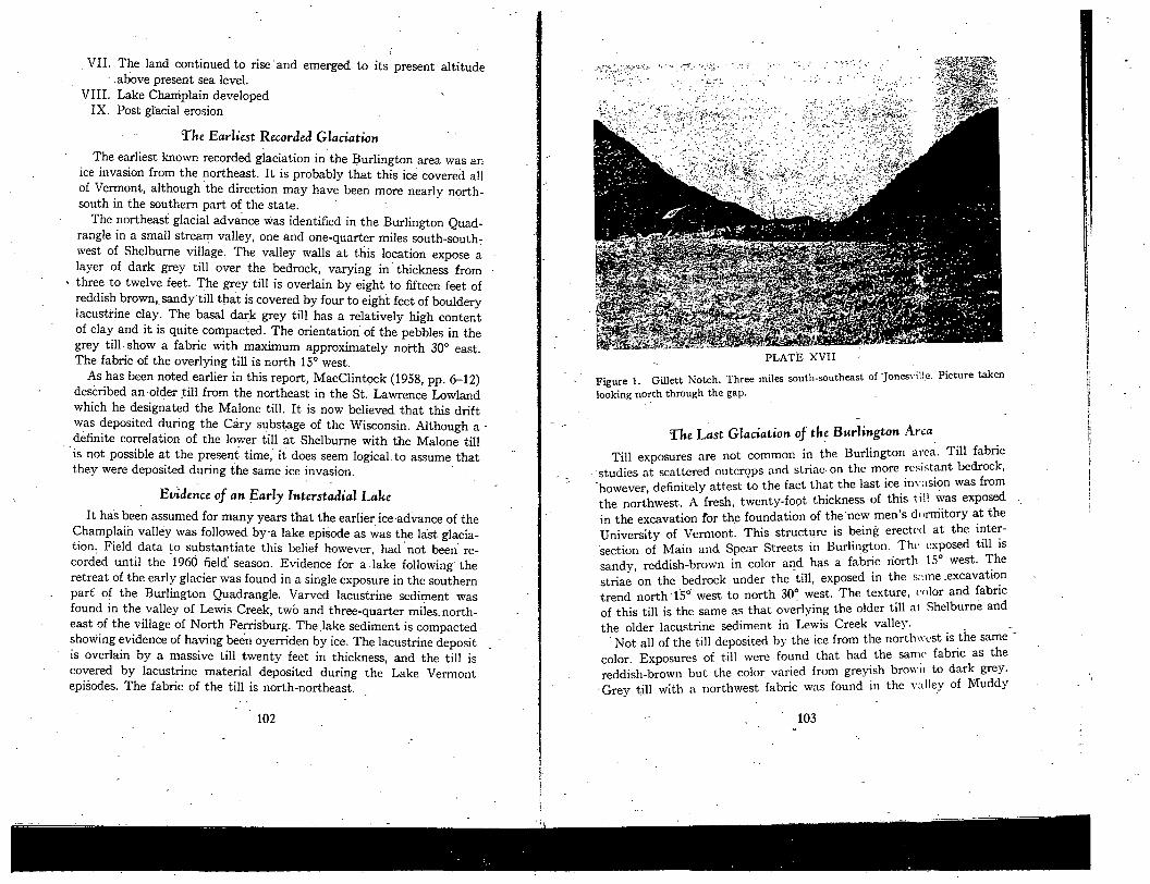
a) a)
a)
ub
a) U
)O
)
C•f)
cd —
O
)
- =
OQ
a)E
-a)
o.I
- + -
a) b
n
o
cd C
)U
)
0
0
—
- .a)
0
d '-
.
= -
- -
. 0
--
-
--
- U
)C
)0
-+
0
a) 'I) a)
0 =
• V
I
cd -l-(J)
•- 0)
ca
.=
G)U
)
0
z
c o -
4-)
an 0
U
)
a
0
—
0. -
—
- boa
-d
U)
. .•
-d
Ca)
U)
- .-
-
U
U)
4)
0
4)
C)
bo
cd
CN
4-)
•.a
Fl
0) )4
- Ca
W
cd 0
0U
)
a))
0)
a)o
-cz
U)
U)oo.-
)4aO
)
0t)cd
cd 0•
•°-U)b
o
o
-d-)
-) U
)
o
C
U)
_4_
b b0
Q -
0
4)
o
cd .
0)_
s
• 0)
—
0j4
) >4
a) —
çC
c000
•-0
c
bo -
=
' -
d
C
Ca U
) a
)*
U)_
•
0) a)
0
a) a
'C
En C
a#)0
-d
c0U
)
--
cd ;d
0_
a)
g
°a
C
-
o
0
0) 0
U)C
0 0)
—
bo •t4
:
- 0)
+) U
) o
(U
)O
a)
CO C
cd
r.
U)d
a) 0
0Q
a)Q
) C
i
. 0-40-0
cd bO
._0U
)
40
U)
+0 -
----
C
*)0
•
0
- C)
.°En
- r .0
0
4-'
U)C
c0
-o-0-d
-
. -
- -
a) ;-.
--
I.- -
U) CO
- C
CO U
. 0)
a) -
4
0)
-s
0) —
'I
In
- b0
0
ta UC
+0 •
a) -
-
- 1
_0 CO
CO
cl
E— -
-
- .d
) (N
00
0a
)C
a)
U)
E.
- -;
-' U
)d0
0) tj
0a
CO
CO
U)0
.C_
a
)+0
ta .2
0 w
°-°
• 0
:
-0U
)C
bO
I
0)00 U
)a0.t0
, C
a. 0
s-'
- -'
u
-CdC
a.-
'PQ
>
Cda)
-
C+
Ca
U
.
0)0
0
d0
- g
-o
9-' C
. C
:
U.,
O--0
0C
aC
U)0
00
0.4
-,

PLATE XVII
Figure 2. Poorly drained upland of the northeast highlands at East Brighton.
Brook on both sides of U. S. Route 2, three miles east of Burlington and along a headwater stream of the LaPlatte River, two miles southeast of Hinesburg. It is the belief of the writer that the variatiozi in the color is due to the bedrock over which the ice moved. The Monkton Quartzite outcrops along the western side of the Burlington Quadrangle. The red color of portions of this formation adds color to the till. The Monkton also increased the Sand content of the till, thus increasing the porosity. and the depth of oxidation. To the west, in the Burlington Quadrangle the bedrock is mostly dark shales and limestones and hence a grey color , to the till.
It has already been noted in this report that ice from the northwest invaded the Stowe and Dog River valleys. These valleys, it is now be-lieved, mark the eastwrd extent of the Northwest glaciation. The southern limit of this ice, however, is yet to be determined.
The kame terraces that overlap the foothills of the Green Mountains in Hinesburg Township were no doubt deposited in association with the northwestern ice advances. There have been several different interpre-tations as to the origin of these deposits (Chapman, 1937, p. 99; Merwin,
1908, P. 119; Fairchild, 1916, p. 24), but the present survey agrees with Chapman that they are kame terraces since they show ice-contact structures. As will be pointed out later in this report, however, these terraces have subsequently been modified by the wave action of two
stages of Lake Vermont. It is too early to propose a definite correlation for the glacial drift
with a northwest fabric. But, as already been noted in this report,
MacClintock (1958, p. 6) described a younger till from the northwest in the St. Lawrence Valley which be designated the Fort Covington. It is now believed that the Port Covington is of Mankato (Port Huron). age (MacClintock and Terasnãe, 1960, p. 239). This report concludes
that the northwestern fabric of the younger till in the Burlington area strongly supports a conclusion that it is a correlative of the Fort Coving-
ton.
Lake Vermont
The lake episodes that developed during the retreat of the last glacier in the Champlain Basin have been collectively called Lake Vermont" A calving retreat of the ice is definitely suggested by the large number of glacially striated boulders embedded in the lacustrine sediments all over the Burlington Quadrangle. One of the best' exposures exhibiting the bouldery nature of the lake deposits is located along the Lake Cham-plain shore at the mouth of Holmes Brook. The calving retreat no doubt explains the absence of till over most of the region. It has been assumed that there were two stages associated with this lake,, but the present survey identified, a third lake stage duringthe 1960 season.
THE HIGHEST LAKE VERMONT—THE QUAKER SPRINGS' STAGE
Woodworth (1905, p. 193) described shore features in New York which he believed to mark an early (high) stage of Lake Vermont. The higher lake he called the "Quaker Springs Stage." Chapman (1937, p. 97),
noted Woodworth's descriptions but discounted them an the belief that they were formed by local, high-level ice-marginal lakes. The present survey in 1959 identified a series of high-level lake-shore phe-nbmena in the Jericho Center-Underhill area and these have already been noted in this report. During the summer of 1960, this shore has
,been traced from Starksboro Township northward to the Lamoille River and it is concluded that a pre-Coveville lake stage did 'oc'ur. Since the name "Quaker Springs" has already been used for simik tr deposits in New York, it seems that this name has priority.
104 ' I. 105

Q;
0
OC
fl rfl
0Q
tfl
Q)
dt.
• _
•.•
_0-
•---
a Cd
0
Cdcd
cd _
0 x
0,
Cd • -
0
4•
4+
0C
)
Cd
C
Cd900 c,
En
—
C)
. C
)Cfl
4.00
41
C.) C.)
. .
-
.c: C
) C
) Cd
• U
) U)
C) 0
-
C Q
Cd C
.0
C)
OG
)C
CU
)
E C
l Cd
0 0
C) C
0(flC
._
C)tC
)+
. Cd
E-
—
U)
C) .
—
0
Cd 0)4•
Cd
.0
U)
En
C) 0
0 0
.0
E- a
C
En 0
.0.b
-
o
C)C
d0
C)U
)'
Cd
a C
p•:
to C
'.
C.-
0
) P4
E-
•°•-'-
L
n
(.0
CO
C)
41
C C
zr.
7• —
—
.0 -
1C -
C)
CdC
ow
.0
C)J)•_
_
-
cd b
b4 0
0
•.0
.C-
(-) -0
0
CI
0Cd
F
Cd
•0
=)
U)0
0-
(5 -
F
Cd - F
U
)•-0
C C
0 C
.)
Cd
00.)0
C
bQ
C)
C)C
)af
C)J
, C)
C)C
)C
d
- -0
$.U
r2
co
UU
d
•
U)
CC
dC
d..00U
)
C)0.)
.
5F
Cd
!:L- -j
a a
jQ
C)C
)C
b0C
0..
)-C
d-
00
C
0.
Cd
CU
)C
d0....
.00
C) U
)C)C
)C)
U)90
.0
0cO
_
t-_
En
U)+
• C
2
-
cli
" •.fl-_ C
.
CC
dL
0
C)C
d
CO
2C
dC
)U
)C
C)0
cC
-Q
.
- -
- -
. $
U
) -C ..
CC
) C
) C
)U
)
0
CC C
Cd.0
CQ
C)C
0.C
dV
C
C.C
)Cd
C)0
bd
Cd
C
) 0
C)<
C
U)
0C
)C
)C
)-.C
,-cd
C
d.0
+__C
).C
o_,oU
)..
CC
- C
)Q
U)F
'C
C
C)U
))
F
CC
-
2F
oC
)
'C
CD

PLATE XVIII
Figure I. Two tills exposed in stream valley, one and three-tenths miles south-southwest of Shelburne Village.
Philo (elevation 540) in the southwestern part of the Burlington Quad-rangle. The same shore is marked by a large beach gravel deposit on the south side of Pease Mountain. The elevation at the top of the gravel is 545 feet. Scattered gravel and .s:u id men ii itilations of the shore of this lake were also found in the Brownell Mountain-Mt. Pritchard 'area, but shore features were absent and no elevations were measured.
At Fay's Corners the Coveville beach gravel has a top elevation of 620 feet and the gravel at this .locality is thicker than those described above. ''herc is also a thick beach gravel deposit on the southeast side of North Williston Hill. The elevation at the base of the wave-cut cliff is 625 feet. Chapman records a Coveville elevation of 641 on this hill.
THE FORT ANN LAKE STAGE
The Shore phenomena of the Fort Ann Stage of Lake Vermont (Chap-man, 1937, pp. '103-113) are poorly developed and quite scattered in the Burlington area. Chapman noted the shore manifestations on Mt. Philo, the Winooski delta and the terrace on Cobble Hill.
PLATE XVIII
Figure 2. Glacial erratic thirty inches across embedded in varved lacustnine clay. Champlain shore at the mouth of Holmes Brook.
The two most noteworthy localities noted during the present survey were on Pease Mountain and Jones Hill. The Fort Ann terrace on Pease Mountain is cut into the beach deposit of Lake Covevilic at an eleva--I-ion of 460 feet. On .Jones 1-1 ill, the Fort Ann beach - gravels rise to an elevation of 465 feet east of the Charlotte cemetery and a prominent terrace is cut in till at the same elevation to the west of the cemetery. This shore is better developed than the beach on Mt. Philo at 540 feet, but the elevations are so ulearl\' the same that, together, with the l'ease Mountain beach, they make a good marker for the lake level in the southwestern part of the Burlington Quadrangle.
A small patch of beach gravel, at an elevation of 525 feet, one-half mile west of North Williston hill is the only other beach deposit of the Fort Ann lake in the Burlington Quadrangle, if indeed this is a deposit of that lake. In the southern part of the Milton Quadrangle, one-half mile north of Butlers Corners, is a gravel deposit that the writer believes should be a Fort Ann beach. The elevation of the gravel, arid the, wave-vashed till to the north of it, are at an elevation of 580 feet. This is several feet higher than the Fort Ann level has been presumed to be in
108 ' ' ' - 109
this area, and the present survey has not progressed far enough north to correlate the deposit with others of that area.
Pre-Champlain Sea Erosion
With the withdrawal of the Fort Covington glacier and the removal of the ice dam in the St. Lawrence valley, the waters of Lake Vermont drained out of the Lake Champlain basin. It is believed that sea level was lower than at the present time, and during the interval the Cham-plain lowland was dry land. The whole region was therefore subjected to weathering and erosion 'befOre the invasion of the Champlain Sea
It must be noted here, however, that evidence of the erosion interval has not been found in the Burlington area. Manifestations of a pre-Champlain Sea erosio'ii have been reported in the St. Lawrence Valley (MacClintock and Terasmae, 1960, p. 238), however, and the same condi-tions doubtlessly existed in the Champlain basin. The only known areas where the erosion might be inferred in the Burlington area are along the Winooski River upstream from Essex Junction. A more or less continu-ous terrace has been traced along this section of the river at elevations of 350 to 400 feet. It has formerly been believed that this terrace was formed during the Champlain Sea episode when the Winooski cut down to the level of the sea. The possibility that the river had already cut down lower than the sea (during the erosion interval) is a question that has not been considered by prior studies. This is a distinction that can-not be easily made, but deposits on the terrace with characteritics closely resembling, beach gravel might be a key to the solution of this problem. Future work, none the less, will have to be done, and it is hoped that better evidence will be found to the north of the Burlington Quadrangle.
The Champlain Sea
Following the erosion interval, the eustatic rise of the sea caused a slow invasion of marine waters into the Champlain basin to form what has been named the Champlain-Sea. The sea rose to a maximum and remained stationary in relation to the land, to form a major shoreline.
THE HIGHEST MARINE SHORE
The highest mai4ne level is well-marked in the Burlington region, and it can be traced with more accuracy- than any of the lake shores. The most southerly Of the shore phenomena are on a ridge two miles south of the village of Charlotte. The fossiliferous beach gravel covers.the top
110
and western side of the ridge to an elevation of 275 feet. Pebbly beach sand marks the shore at the same elevation between the ridge and Jones Hill just north of the village. From Charlotte, the shore can be traced almost continuously to Burlington. The excavation for the foundation of the new wing of the DeGoesbriand Memorial Hospital was dug in the beach deposits of the sea. Because of man-made changes in this area, it is difficult to obtain a reliable elevation, but' is estimated that the top of the gravel is approximately 340 feet. Between Shelburne Village and Burlington, the sands of the Winooski River delta' lap upon the 'sides of the hill, and in most areas the sand is capped with beach gravel that spreads out from a prominent sea cliff. The deltaic structure of the sand was well-exhibited in a sand pit in South Burlington, one and one-half miles, due east of Red Rock' Point. The marine origin of the deposit was shown by the fossils contained in the foreset beds. The Winooski Delta sands are found all over the South Burlington, Burlington and Winooski sections since the sands were spread out from the Winooski Valley at
Essex Junction. - - -
THE WITHDRAWAL OF THE CHAMPLAIN SEA
After the sea had remained stationary with respect to the land for a short time, the land finally began to rise out of the sea. Marine beach deposits at various levels below the high shore indicate that the with-drawal was relatively slow and more Or less continuous. Chapman,, (1937, pp., 116-121) proposed three distinct stages in the lowering of the marine water when the water level was again stationary in relation to the land. The findings of the present survey thus 'far do not support this conclusion inasmuch as no definite water plane'can be established from the data collected. It seems more likely that the water withdrew at a slow but constant rate and that shore phenomena developed be-cause of the conditions along the shore. All of the better beach deposits below the high marine level seem to be located in areas that were pro-tected by high rock outcrops or other topographic features.
The isostatic rise of the land continued until the land was elevated to its present altitude. After the marine waters withdrew, Lake Cham-plain developed in the Champlain basin. Erosion has subsequently modified much of the land surface to form the present topography.
-' The Monbton Quartzite Boulder Train
The Monkton Quartzite boulder train (indicator fan) has been men-tioned earlier and is located 'on the ie direction map (Plate II) of this
111 '

report. As has been pointed out, the information concerning the boulder train, was from the literature inasmuch as the present survey had not studied the Burlington area until the 1960 field season. After having worked a summer in that region, the writer feels that some clarification of this indication fan should be made.
The Monkton Quartzite, because of its texture, slight metamorphism and color is a very distinctive rock. It is easily identified, and it is con-spicuous in the deposits in which it is found. For this reason, it is a good marker. It should be pointed out, however, that the size of the area in which this formation outcrops limits its use as an indicator of ice direc-tion. Whereas the most desirable boulder trains spread out frbm a distinctive rock outcrop of small areal extent, the Monkton Quartzite is exposed for a distance of approximately sixty miles in a north-south direction on the Champlain lowland. It is, therefore, impractical to use this rock locally, as a measure of the direction of ice movement. It should be used only in a general way in regions farther removed from the area of outcrop, as; for example, east of the Green Mountains.
The Essex Esher
The only esker that has been noted in the five years of the current survey was mapped in the Burlington area. For this reason, this feature has special interest in that -area, in spite of the fact that it has little geologic significance.
The esker is located along Alder Brook, three-quarters of a mile north-northeast of -Essex Center in Essex Township. Thus, it is designated the "Essex Esker" in this report. The gravel ridge runs generally north-south for a distance of two and one-quarter miles, exhibiting the charac-teristic sinuous trend of the textbook description. The esker is mostly along the eastern side of Alder Brook, but it splits into two ridges at the south end and one of the p.rongs is on the western side of the stream. The extreme northern end also crossed to the west side of the brook: The esker is higher. and the material is coarser at the south than at the north. -
the width varies from one to five miles. There is no stream through the valley, the drainage being through portions of Otter Creek, Batten Kill, and the Walloomsac River and their, tributaries. -
- - The writer believes that the last glacier to invade the Champlain Lowland, the Fort Covington, moved down the Vermont valley. Be-cause of the narrowness of the valley and the heights of the steep walls on either side, the basal ice moved southward and scoured to consider-able depth. To the writer's knowledge there are no published figures as to the depth to bedrock or the thickness of the sediment flooring the
• valley. -' -
Various types of sediment cover the valley floor. Much of the material • is kame gravel, but reports of material encountered in the drilling of
water wells indicates that there might be a sequence of till and outwash composed of several derent layers. Gordon (1942, p. 1847) stated that his study of the outwash gravel indicates that all of the various stages
• of deglaciation" represented were formed in association with stagnant ice. The absence of frontal moraines here, as elsewhere in Vermont, are manifestations of stagnation. Gordon (1942) believed that "much of the till on the mountain slopes also suggests that the ice melted dow
-
n
from the mountain summits."
THE GLACIATION OF THE TACONIC MOUNTAINS The Taconic Mountains, in the extreme southwestern part of the
state, extend for 78 miles from the Massachusetts border to the vicinities
of Brandon and Sudbuxy (Figure 2). - Of all the areas of Vermont, the data on the glacial geology of this
region is the least known. Like the Green Mountains, this area was first studied to ascertain whether or not it had been glaciated and-later to determine the type of glaciers that had been active there. The summits of the mountains are covered with glacial materials and poorly preserved striations trending in a southeasterly direction (Hitchcock, C. H., 1904, p. 76). This same trend has been noted on the higher areas of the Taconic
peaks to the south in Massachusetts. -
- THE GLACIATION OF THE VERMONT VALLEY The Vermont valley is a long, narrow lowland that is located between
the Taconic and Green Mountains. In Vermont it trends generally south-

1933a, Waning of last ice sheet in central Massachusetts: Jour. Geology, v. "S 41, p. 144-58. 1933b, Glacial lakes and ice movements . . . Millef's River valley. Massa-
chusetts (Abstract): Geol. Soc. America Bull., v. 44, p. 175-76. -, 1934a, History of Nashua and Miller's River valleys in ate glacial time (Ab-
stract): Geol. Soc. America Proc., (1934), p. 70. -, 1934b, Evidence of stagnant ice in glacial lakes, Hadley and Montage in
Connecticut valley. (Abstract): Geol. Soc. America Proc., (1933), p. 450.
BRYAN, K., 1936a, Late glacial history of southeastern New England (Abstract):
Geol. Soc. America Proc., (1935), p. 68. • --, 1936b, Geologic features in New England ground water supply: New England
Water Works Assoc. Jour., v. 50, p. 222-28.
CHAPMAN, C. H., 1937, Late glacial and post-glacial history of Champlain valley:
Am. Jour. Science, 5th Ser., v. 34, p. 89-124. -, 1941, Late glacial and post-glacial history of the Champlain valley, Vennont:
Vermont State Geologist, 23rd Report, (1941-42), p. 48-83.
CHRISTMAN, ROBERT A., 1959, Geology of the Mount Manslield Quadrangle, Ver-
mont, Vermont Geol. Survey, Bull. 12.
- and DONALD T. SECOR, Ja., in press, Geology of the Camels Hump Quadrangle,
Vermont, Vermont Geol. Survey Bull. -
CHUTE, N. E., 1950, Surface geology of Brockton Quadrangle. Massachusetts: U. S.
Geol. Survey Quad. map with text.
CLARKE, J. M., 1907, Lake Champlain (Abstract): Science n. s. v. 26, p. 400.
COLEMAN, A. P., 1930, Extent of Winsconsin glaciation: Am. Jour. Science, v. 20,
p. 180-83. -, 1932, Interglacial Champlain Sea: Am. Jour. Science, v. 24, p. 311-15.
-, 1941, The last million years: Univ. of Toronto Press.
COOKE, C. W., 1932, Correlation of American glacial chronology with marine time
scale: Wash. Acad. Science Jour., v. 22, p. 310-12. -, 1935, Tentative ages of Pleistocene shorelines: Wash .Acad. Science Jour., v.
25, p. 331-33. COOKE, J. H., 1924, Disappearance of last glacial ice sheet from eastern New York:
New York State Mus. Bull., No. 251, p. 158-76.
CooK, T. A. 1933, Geology of Connecticut: Bond Press, Hartford, Conn., 112 p.
COOPER, WILLIAM S., 1959; Terminology of post-Valders time: Geol. Soc. America
Bull., .v. 70, p. 666 CROSBY, I. B., 1933, Glacial and recent history of Black River valley, Vermont
(Abstract): Geol. Soc. America Bull., v. 44, p. 81. 1934a, Extension of Bethlehem, New Hampshire Moraine: Jour. Geology, v.
42, p. 411-21. 1934b, Geology of Fifteen Mile Falls development dam construction in glacial
valley: Civil Eng., v. 4, p. 2 1-24.
CROSBY, W. 0., 1928, Outline of the geology of Long Island, New York: Ann. New
York Acad. Sci, p. 425-429.
CURRIER, L. W., 194 Ia, Dissipation of the last ice sheet--stagnation zone retreat
(Abstract): Geol. Soc. America Bull., v. 52, p. 1895-6. -, 1941b, Tills of eastern Massachusetts (Abstract) C,eol. Soc. America Bull.,
v. 52,-p. 1895-6.
BIBLIOGRApHy ADAMS, C. B., 1846 Vermont State Geologist, 2nd Report. ADAMS, G, F., 1945, Upland terracei in southern New England: Jour. Geology, V. 53, p. 289-312. ALDEN, W. C., 1931, Stagnation of last ice sheet in New England: Am. Jour. Science,-
5t1i Ser., v. 22, p. 172-74. ALLISON, I. S., 1935, Correlation of glacial terraces by means of soils (Abstract):
Geol. Soc. America Proc., (1934), p. 63. ANDERSSON, J. G., 1906, Solifluction 1 a component of subaerial denudation: Jour.
Geology, v. 14, p. 91-112. ANTEVS, ERNST, 1922, Recession of last ice sheet in New England: Am. Geo. Soc.
Res.Ser.No. 11, 120p.
1925, Pleistocene pre-Wisconsin beds in Vermont (Abstract): Geol. Soc. America Bull., v. 36, p. 154-55.
-, 1928, Last glaciation with special reference to ice retreat in northeastern North America: Am. Geog. Soc. Res. Ser. No. 17, 292 p.
1932, Late glacial clay chronology of Nrth America: Smithsonian Inst. Ann. Rept., (1931), p. 313-24.
-, 1934, Climates of last glaciation in North America: Am. Jour. Science Proc., (1933), p. 449-59.
-, 1939, Modes of retreat of Pleistocene ice sheets: Jour. Geology, v. 47, p. 503.r08. 1945, Correlation of Wisconsin glacial maxima: Am. Jour. Science, v. 243-A,
Daly Vol., p. 1-39. -
-, 1957, Geological tests of the varve and rádiocai-bon chronologies: Jour. Geology, v. 65, p. 129-48.
BAIN, G. W., it al, 1942, Flow of time in the Connecticut valley: Geologic Imprints, Hampshire Bookshop, Northampton, Mass., 129 p.
BALDWIN, S. P., 1894, Pleistocene history of Champlain valley: American Geologist, v. 13, p. 170-84.
BALK, R., 1942, Geologic story of the mountains-the Friendly mountains; Green, White, and Adirondacks: Peattie ed., Vanguard Press, N Y., p. 75-12 1.
BloeLow: E. L. 1933, The last lake of the Stowe valleys: Vermont State Geologist, 18th Report, (1931-1932), p. 358-62.
BILLINGS, M. P., 1946, Some major problems in New England geology (Abstract): Geol. Soc. America Bull., v. 57, p. 1277-8.
BRAUN, E.. L., 1951, Symposium-Glacial border; climate, soil, hiotic effect: Ohio Jour. Science, v. 51, p. 105-46.
BROWN, R. W., 1930, Section at Stiles clay pit: Connecticut State Geol. and Nat. Hist. Survey Bull. 47, p. 263-66.
BROWN, T. C., 1929, Late glacial history of Nashua valley in central Massachusetts (Abstract): Geol. Soc. America Bull., v. 40, p. 128.
1930, Evidence of stagnation during deglaciation of Nashua valley: Am. Jour. Science, 5th Ser., v; 19, p. 359-67.
-, 1931, Kames and kame terraces in cential Massachusetts: Geol. Soc. America - Bull. v. 42, p. 467-79. -
1932, Late Wisconsin ice movements in Massachusetts: Am. Jour. Science, 5th Ser., v. 23, p. 462-68.
114 1 . - . . 115.

DALY, R. A., 1920, Oscillations in level in belts peripheral to Pleistocene ice caps: Geol. Soc. America Bull., v. 31, p. 303-18.
DANA, J. D., 1863, Manual of geology: Theodore Bliss and Co., Philadelphia, p. 535-558.
1870, Memoir on the geology of the New Haven region: Transactions of the Conn. Acad.,-v; 2.
-, 1871, On Connecticut River valley glacier and other examples of glacial move-ments along the valleys of New England: Am. Jour. Science 3rd Ser., v. 2, p. 233-43.
-, 1873, On the Glacial and Champlain eras in New England: A-in, jour. Science, 3rd Ser., v. 5, p. 198-211.
-, 1875-5, Southern New England during the melting of the great glacier: Am. Jour. Science, 3rd Ser., v. 10, p. 168, 280, 353, 409-38.
1876, On the damming of streams by drift ice: Am. Jour. Science, 3rd Ser., v. 11, p. 178-80. -
1881, On relation of so-called kames" of Connecticut River valley to terrace formation: Am. Jour. Science, 3rd Ser., v. 22, p. 451-68.
DANA, R. A., 1882, Flooding of Connecticut River valley from melting of Quater-nary glacier: Am. Jour. Science, 3rd Ser., v. 23, p. 87-97, 179-203; v. 24, p. 98-104.
1883, Evidence from southern New England against iceberg theory of drift: Science, v. 2, p. 390-92.
-, 1893, On New England and upper Mississippi basin in glacial period: Am. Jour. Science, 3rd Ser., v. 46 p. 327-30.
DAVIS, M. B., 1958, Three pollen diagrams from Central Massachusetts: Am. Jour. Science, v. 256, p. 540-70.
DAVIS, W. M., 1902, Terraces in New England: Museum of Comparative Zoology Bull., v. 38, Harvard University, p. 282-346. -
DEEVY, B. S., JR., 1939, A post-glacial climatic chronology for southern New Eng-land: Am. Jour. Science, V. 37-8, p. 691-724.
-, 1943, Additional pollen analyses from southern New England: Am. Jour. Sci-ence, v. 241, p. 717-52.
1949, Biogeography of the Pleistocene. Part I, Europe and North America: Geol. Soc America Bull., v. 60, p. 1315-416.
-, 1951, Late glacial and post-glacial pollen diagrams from Maine: Am. Jour. Science, v. 249, p. 177-207.
Dir GEr.R, BARON, 1893, Pleistocene changes of level in eastern North America: Am. Geologist, v. 11, p. 22-44.
DEMOREST, MAX, 1942, Glacial thinning during deglaciation: Am. Jour. Science, v. 240, p. 31-66. -
DENNY, C. S:, 1941, Glacial drift near Canaan, New Hampshire (Abstract): Geol. - Soc. America Bull., v. 52, p. 1897.
-, 1950, Pleistocene studies.of USGS and relation to soils (Abstract): Geol. Soc. America Bull., v. 61, p. 1565-6.
-, Friends of the Pleistocene, 17th Reunion (Pennsylvania and New York): Sci-ence, v. 120, No. 3119, p. 554.
1956, Wisconsin drifts in the Elmira region, New York and their possible equiv-alents in New England: Am. Jour. Science, v. 254, p. 82-95.
DOLL, C. G., 1937, Glacial pothole on the ridge of the Green Mountains near
Fayston, Vermont: Vermont State Geologist, 20th Report, (1935-36), p. 145-51. -, 1938, Geology of Clay Point, Colchester, Vermont: Vermont State Geologist,
21st Report, (1937-38), p. 73. ---, 1941, Geology of the Memphremagog Quadrangle, Vermont (Abstract): Geol.
Soc. America Bull., v.52, p. 2014. -, 1941, Abandoned valley at West Charleston, Vermont: Vermont State Ge-
ologist, 23rd Report, (1941-42), p. 21-25. 1943, Preliminary Report on Strafford Quadrangle, Vermont: Vermont State
Geologist, 24th Report, (1943-44), p. 14-28. -, 1951, Geology of the Memphremagog.Quadraflgle and southeastern Irasburg
Quadrangle: Vermont Geol. Survey, Bull. 3. DREIMANIS, A., 1958, -Wisconsin Stratigraphy- at Port Talbot on the north shore of
Lake Erie, Ontario: Ohio Jour. Science, v. 58, p. 65-83. EGOLESTON, J. W., 1929, Glacial geology and the Vermont flood: Science N. S., v.
69, p. 62 1-22. ELSON, J. A., 1957, Lake Agassiz and the Mankato-Valders problem: Science, v.
126, p. 999. EMMONS, EBENEZER, 1838, Report of the second geological district of the state of
New York: New York Geological Survey, Second Annual Report. FAIRCHILD, H. L:, 1914, Pleistocene submergence of Connecta:ut and Hudson val-
leys: Geol. Soc. Ameriqa Bull., v.25, p. 6345, 219-42. -, 1916, Post-glacial marine waters in Vermont: Vermont State Geologist, 10th
Report., 1915-16, p. 1-41. -, 1918, Glacial depression and post-glacial uplift of northeastern America: Nat.
Acad. Science Proc., No. 4, p. 229-32. 19 19a, Pleistocene marine submergence of Hudson, Champlain and St. Lawrence
valleys: New York State Museum Bull., Nos. 209-10, 76 p. - 1919b,. Post-glacial sea level waters in eastern Vermont: Vermont State Ge-
ologist, 11th Report, (1919-20). p. 52-75. 1919c, Post-glacial uplift in southern New England: Geol. Soc. America Bull.,
v. 30, p. 597-636. FENNEMAN, N. M., 1938, Physiography of the eastern United States: McGraw-Hill,
New York, p. 343-92. FISHER, E. - F., 1906 Terraces of the West River, Brattichoro, Vermont: Proc.
Boston Soc. Nat. Hist., v. 33, No. 2, p. 9-42. -. FI.IrMINC., W. L. S., 1935, Glacial geology of Central Long Island: Am. Jour. Science,
v. 30, p; 216-238. - - - FLINT, A. F., 1929, Stagnation and dissapation of the last ice sheet: Geog. Rev.,
v. 19, p. 256-89. 1930a, Glacial geology of Connecticut: Connecticut State Geol. and Nat. Hist.
Survey Bull. 47. - - - 1930b; Classification of glacial deposits: Am. Jour. Science, 5th Ser., V. 19,
p. 169-76. - 1931a, Terraces in the Connecticut valley: Science N. S., v. 74, p. 368-69.
--, 1931b, Stagnation of last ice sheet in New England: Am. Jour. Science, 5th
Ser., v. 24, p. 174-76. . . . - -, 1932, Deglaciation of Connecticut valley: Am. Jour: Science, 5th Ser., v. 24,
p.. 152, 56. -

-, 1933 Late Pleistocene sequence in the Connecticut valley: Geol. Soc. America Bull., v. 44, p. 963-88. -
-' 1934, Late glacial features of Quinnipiac-Farmington lowland, Connecticut: - Am. Jour. Science, v. 27, P. 81-91.
1935a, Climates of the Pleistocene: Am. Jour. Science, v. 29, p. 381-83. -,
1935b, How many glacial stages recorded in New England: Jour.- Geology, v. 43, p. 711-77.
1936, Pleistocene terraces of Connecticut lowland: Cong. Intern. Geol., War-saw, Tray. Sec. II, tome 2, p. 5 19-73.
1941, Pleistocene strand lines; a rejoinder: Am. Jour. Science, v. 239, p. 459- 62. -
-, 1942, Glacial thinning during deglaciation: Am. Jour. Science, v. 240, p. 113-36.
-, 1943, Growth of North America ice sheet-Wisconsin age: Geol. Soc. America, v. 54, p. 325-62. -
1945, Chronology of Pleistocene epoch: Fla. Acad. Science Quart. Jour., v. 8, No. 1.
1947, Glacial geology and Pleistocene epoch: John Wiley and Sons, New York, 589 p.
-, 1949a, Pleistocene research; Committee report: Geol. Soc. America Bull., v. 60, p. 1305-525.
-, 1949b, Late Pleistocene dates . . . radiocarbon assays: Science, v. 109, p. 636. 1950, Report of committee on radiocarbon 14 (Abstract): Geol. Soc. America
Bull., v. 61, p. 1517-8.
et al, 1951a, Radiocarbon dating of late Pleistocene events: Am. Jour. Science, v. 249, p. 257-300.
-, 1951b, Highland glacial centers of former glacial outfiowin northeastern North America: Geol. Soc.America Bull., v. 62, p. 21-37.
1952, The ice age in the North American Arctic: Arctic, v. 5, p. 135-52. 1953, Probable Wisconsin substages and late Wisconsin events in northeastern
United States and southeastern Canada: Geol. Soc. America Bull., v. 64, p. 897-919.
-, 1936, New radiocarbon dates and late Pleistocene stratigraphy: Am. Jour. Science, v. 254.
1957, Glacial and Pleistocene geology: John Wiley and Sons, New York, 553 p. FOWLER, P., 1950, Stratigraphy and structure of Castleton area, Vermont: Vermont
Geol. Survey Bull., 2, p. 10-11.
FOVE, W. G., 1949, Geology of eastern Connecticut: Connecticut Geol. Nat. Hist. Sur. Bull., No. 74.
FULLER, M. L., 1914, The geology of Long Island, New York: U.S.G.S. Prof. Paper 82,231p. - -
GOLDRING, WINIFRED, 1922, Champlain sea; decreased sdlinity southward: New York State Museum Bull., Nos. 239-40, p. 153-94.
GOLDTRWAIT, J. W., 1916, Evidence for and against former existence of local glaciers in Vermont: Vermont State Geologist 10th Report, (1915-16), p. 42-73.
-, 1920, Submergence and post-glacial uplift in NewHampshjre (Abstract): Geol. Soc. America Bull., v. 31, p. 112-13.
-
-, 1922, Glaciation of New Hampshire ((Abstract): Geol. Sue. America Bull.,
v. 33, p. 86. - 1925, Geology of New Hampshire: New Hampshire Academy Science, Hand-
book No. 1, Rumford Press, Concord, N. H., 86 p. 1938, Uncovering of New Hampshire by last ice sheet: Am. Jour. Science, v.
36, p. 345-72. -, LAWRENCE G0LDrHWAIT and R. P. Gou)THWAIT, 1951, Surface geology of
New Hampshire, pt. 1: New Hampshire State Planning and Development Comm. GdLDTHWAIT, LAWRENCE, 1941a, Two (?) tills in New Hampshire (Abstract): Geol.
Soc. America Bull., v. 52, p. 1904-5. -; 1941b, Survey of glacial tills in New Hampshire (Abstract): New Hampshire
Acad. Science Proc.,.v. 1, No.3, p. 17. -, 1948, Glacial till in New Hampshire: New Hampshire State Planning and De-
velopment Comm; Mineral Res. Survey, pt. 10, P. 3-11. ---, 1949, Clay Survey: Maine State Geol. Rept., (1947-48), p. 63-9. GORDON, C. B., 1926, Notes on geology of the townships of Bristol, Lincoln and
Warren: Vermont State Geologist 15th Report, (1925-26), p. 272-318. -, 1941, Glacial features near Bennington, Vermont (Abstract): Geol. Soc. America
Bull., v. 52, p. 2016. -, 1942, Deposits associated with wasting glacial ice in Vermont valley from
Shaftsbury to Rutland (Abstract): Geol. Soc. America Bull., v. 53, p. 1847.
[-IADLEY, J. B., 1950, Geology of the Bradford Thetford area, Orange County, Ver-
mont: Vermont Gaol. Survey Bull, 1.- HANSEN, W. R., 1953, Late Tertiary and Pleistocene drainage changes in Hudson
and Maynard Quadrangles, Massachusetts: Jour. Geology, v. 61. p. 353-62. 1-IITCBCOCK, C. H., 1879, Glacial period in eastern America: Geol. Mag., v. 6, p.
248-50. -, 1892a, Studies of Connecticut valley-glaciation: Geol. Soc. America Bull., v. 4,
p. 3-7. -, 1892b, Terminal moraines in NewEngland (Abstract): Am. Geologist, v. 10,
p. 219-20. 1893, A single glacial period in New England: Am. Geologust, v. 11, p. 194-93.
-, 1894, High-level gravels in New England: Geol. Soc. America Proc., Seventh
Annual Meeting, p. 460. -, 1895a, High-level gravels in New England (Abstract with discussion by J. W.
Spencer): Geol. Soc. America Bull., v. 6, p. 460-61. 1895b, Champlain geological epoch: Am. Geologist, v. 16, p. 235-36. 1900, Evidence of interglacial deposition in Connecticut valley (Abstract):
Geol. Soc. America Bull.. v. 12, p. 9-10. 1904, Glacier of Green Mountain Range: Vermont State Geologist, 4th Re-
port, (1903-04), p. 67-85. -, 1906a, The Champlain deposits of northern Vermont: Venuunnt State Geologist,
5th Report, (1905-06), p. 236. -, 1906b, Sürficiscl geology of region about Burlington, Vermont: Vermont State
Geologist, 5th Report, (1905-06), p. 232-35. - -, 1907, Glacial Lake MemphremagOg (Abstract): Science N.. S., v. 25, p. 773;
Geol. Soc. America Bull., 18, p. 641-42, 1908.
118 - I. . . -. 119

-, 1908a, Geology of Hanover, New Hampshire: Vermont State Geologist, 6th Report, (1907-08), p. 139-86.
1908b, Glacial Lake Memphremagog: Geol. Soc. America Bull., v. 18, p.641- 42.
-, 1910, Surficial geology of Champlain basin: Vermont State Geologist, 7th Report, (1909-10); p. 199-212.
HITCHCOCK, EDWARD, 1841, First anniversary address to the Association of American Geologists: Am. Jour. Science, v. 41. -
--, et al, 1861, Report of geology of Vermont. Claremont, New Hampshire: 2 - volumes. -
HOBBS, W. H., 1947, Deglaciation of continental glacier (Abstract): Geol. Soc. America Bull., v. 58, p. 1193:
HORBERG, C. L., 1952, Interrelationships of geomorphology, glacial geology and Pleistocene geology: Jour. Geology, v. 60, p. 87-90.
HOUGU, JAcK L., 1958, Geology of the Great Lakes: Univ. of Illinois Press, Urbana, Illinois, 313 p.
HUBBARD, G. D., 1918, Possible local glacial in southern Vermont: Assn. America, Geogr., v. 7, p. 77.
1924, Geology of a small tract in south central Vermont (Whitingham area): Vermont State Geologist, 14th Report, (1923-24), p. 260-343.
HUNGERFORD, E., 1868; Evidence of glacier on Green Mountain summits: Am. Jour. Science, 2nd Ser., v. 45, p. 175.
JACOBS, E. C., 1927, Flood erosion at Cavendish, Vermont: Science, N. S., v. 66, p. 653-54.
• 1938, The geology of the Green Mountains of northern Vermont: Vermont State Geologist, 21st Report, (1937-38), p. 1-73.
-, 1941, Green Mountains of northern Vermont (Abstract): Geol. Soc. America Bull., v. 52, p. 1281-82.
1942, Great ice age in Vermont: Vermont State Geologist, 23rd Report, (1941-42), p. 26-47.
---, 1946, The Vermont geological survey, 1844-46: Vermont State Geologist, 25th Report, (1945-46), p.. 1-45.
--, 1950, Physical features of Vermbt: Vermont State Development Comm., Montpelier, Vt.
JAHNs, R. H. and WILLARD, MAX E., 1942, Late Pleistocene and recent deposition in Connecticut valley, Massachusetts: Am. Jour. ScieniSe, v. 240 p. 161-91, 265-87.
-, 1943, Sheet structure 'in granite—use to measure erosion in New England: Jour. Geol., v. 51, p. 71-98.
-, 1947, Geologic features of Connecticut valley, Massachusetts-rel1tjol to ter-race floods: U.S.G.S. Water Supply Paper 996.
1951, Surface geology of Mt. Toby Quadrangle, Massachusetts: U.S.G.S. Quad. map GQ.9.
1953, Surface geology of Ayer Quadrangle, Massachusetts: U.S.G.S. Quad. map GQ-2l.
JONES, D. V., 1916, Physiography of Greensboro, Hardwick and Woodburr, Ver; nsOnt Vermont State Geologist, 10th Report, (1915-16), p. 74-100.
KARLSTROM, T. N. V., 1956, The problem of the Cochrane in late Pleistocene chro-nology: U.S. Geol. Survey Bull., 1021, p. 303-331.
KEYES, C. R., 1934! Glacial concepts before Agassiz: Pan Am. Geol., v. .62, p. 283-
300. -, 1937, Fast vanishment of morainic fronc of glacial till sheets:- Pan Am. Geol.,
V. 68, p. 263-84. KNOX, A. C., 1948, Late glacial and postglacial chronology for eastern New England
(Abstract): Am. Jourr Botany, v. 35, p. 805. KRIEGER, M. H., 1937, Geology of Thirteenth Lake Quadrangle New York: N.Y.
State Museum Bull., 308. KRYNINE, P. - D., 1937, Glacial sediments of Quinnipiac-Pefluabuck lowland of
Connecticut: Am. Jour. Science, V., 33, p. 111-39. -, 1938, Pleistocene sediments in 'Briston, Connecticut (Ahstract) Geol. Soc.
America Proc., (1937), p. 95-6. --, 1938, Ad unusual ice contact delta (Abstract): Geol. Soc. America Proc.,
. -
(1937), p. 95. ' 'LEIGHTON, M. M., 1933, The naming of the subdivisions of the Wisconsin glacial
age: Science N. S., v. 77, p. 168. 1957, The CaryMankatO-V4d problem: Jour. Geology, v. 65, p. 108-il. 1958, Important elements in the classification of the Wisconsin glacial stage:
Jour. Geology, v. 66, p. 288-309. -, 1959, Important elements in the classification of the Wisconsin glacial stage-
a reply: Jour. Geology, v. 67,p. 594-98. -, and WILLMAN, H. B., 1950, Loess formations of the Mississippi valley:
Jour. Geology, v. 58, p. 599-623. LEOPOLD, E. B., 1955, Climate and vegetatiOn changes in southem Connecticut
during the Two Creeks interstadial: Unpub. Ph.D. dissert., Yale University. 1956, Two late glacial deposits in southern Connectout: Natl. Aced. Sci.
Proc., v. 42, p. 863-76. LEVERETT, FIs.NK, 1903, Summary of literature of North American Pleistocene
Geology 1901-02: Jour. Geology, v. 11, p. 420-28, 498-515, 587-611. LOUGEE, R. J., 1935, Hanover submerged: Dartmouth Alum. Mag., v. 27, p. 5-8
1939, Geology of Connecticut watershed: New Hampshire Fish and Game
Commission, Geol. Surv. Connecticut Watershed, Report 4, p. 131-49. -, 1940, Deglaciation nf New England: Jour. Geomorph., v. 3, p. 189-215. MAcCIINTOCK, PAUL and RICHARDS, H. G., 1934, Correlation of marine and glacial
Pleistocene deposits of the middle Atlantic seaboard (Abstract): Geol. Soc. America
Proc., December Meeting (1934). MAcCLINTOCK, PAuL, 1952, Leaching of Wisconsin glacial gravels in eastern New
England (Abstract): Geol. Soc. America Bull., v. 63, p. 1277. --, 1954a, Leaching of Wisconsin gravels in eastern North America: Geol. Soc.
America Bull., v. 65, p. 369-83. ,1954b, Pleistocene glaciation of St. Lawrence lowlands: New York State Sci-
ence Service, Prog. Report, Investigation, No. 10. -, 1958, Glacial geology of the St. Lawrence seaway and power project: N. Y.
State Mus. and Sci. Service. -, 1959, A till fabric rack: Jour. Geology, v. 67, p. 709-11). - - -, and TERASMAR J., 1960, Glacial History of Covey Hill: Jour. Geology, v. 68,
p. 232-41. - - -, and STEWART, DAVID P., in press, Glacial geology of - the St. Lawrence low-
land: N. Y. State Mus. and Sci. Service.
120 .
MARTIN, L., 1934, Standard maps of maxima of Pleistocene glaciation on North America (Abstract): Geol. Soc. America Proc., (1933), p. 96.
MATRER, K. F., et al, 1941, Retreatal stages in Wisconsin ice in southeastern Massa-chusetts (Abstract): Geol. Soc. America, v. 52, P. 2018.
MATFHES, F. E., 1945, Post-pleistocene deglaciation and reglaciation (Abstract): Geol. Soc. America, v. 56, p. 1181.
MERRITT, R. S. and MULLER, E. H., 1959, Depth of leaching in relation to carbonate content of tillin New York State: Am. Jour. Science, v. 257, p. 465-80.
MERWIN, H. E., 1908, Some late Wisconsin and post-Wisconsin, shorelines of north- western Vermont: Vermont State Geologist, 6th Report, (1907-08), p. 113-38.
MEYERHOFF, -H., 1929, Erosional landforms of east and central Vermont: Vermont State Geologist, 6th Report, (1927-28), p. 315-81. -
-, 1946, Upland terraces in southern New England: Jour. Geology, v. 54, p. 126-
29. - -
MILLER, W. J., 1921, Geological history of Connecticut valley of Massachusetts: The Hampshire Bookshop, Northampton, Mass., 74 p. -
- MILLS, J. R., 1951, Study of Lakes in northeastern Vermont: Vermont Geol. Survey Bull., 4.
MOORE, G. E., 1949, Geology of Kenne-Brattleboro, New Hampshire-Vermont: N. H. State Plann. Dee. Comm. -
NEWLAND, D. H., 1942, Guide to geology of Lake George region: N. Y. State Mus. Handbook 19. -
OGDEN, J. GORDON III, 1959, A late-glacial pollen sequence from Martha's Vine-yard, Massachusetts: Am. Jour. Science, v. 257, p. 366-81.
OGILvIE, I. H., 1902, Glacial phenomena in Adirondack and Champlain valley: Jour. Geology, v. 10, p. 397-412. - -
PERT, C. E., 1904, Glacial and post-glacial history of Hudson and Champlain val-leys: Jour. Geology, V. 12, p. 415-69, 617-60.
PELTIER, L. C., .1950 (Sept.), Geographic cycle in periglacial regions: Am. Assoc. Geographers Annual, v. 40, p. 214-36..
PERKINS, G. H.,' 1902, List of reports on geology of VermOnt, 1845-1900: Vermont State Geologist, 3rd Report, (1901-02), p. 14-21.
-, 1904, List of works on geology of Vermont: Vermont State Geologist, 4th Re-port, (1903-04), p. 16-21. - - -1912, General account of geology of Vermont: Vermont State Geologist, 8th
Report, (1911-12), p. 17-100.
1923, History and summary of geological work in Vermont 1810-1923: Ver-mont State Geologist, 13th Report, (1921-22), p. 1-70.
PERRY, J. B., 1872, Hints toward post-Tertiary history of New England: Boston Soc. Nat. Hist., Pr. 15, p. 48-148.
REEDS, C. A. and ANTEVS, E. ,V., 1930, Maps of Pleistocene glaciation: Geol. Soc. America Bull., v 41, p. 115. -
RICH, J. L., 1943, Buried stagnant ice as normal product of a retreating glacier in a hilly region: Am. Jour. Science, v. 241, p. 95-100.
RICHARDS, HORACE G., 1953, Record of the rock: the geologic story of eastern North America: The Ronald Press Co., New York, p. 331-79.
RICHARDSON,. C. H., 1906, Areal and economical geology, of northwest Vermont: Vermont State Geologist, 5th Report, (1905-06), p. 63-115. -
—. 1908, The-geology of Newport; Troy and Coventry: Vermont State Geologist, 6th Report, (1907-08), p. 265-91.
122
-, 1914, Geologyand mineralogy of Hardwick and Woodlury, Vermont: Ver-mont State Geologist, 9th Report, (1913-14), p. 294-336.
-, 1916, Geology of Calais, East Montpelier and Berlin, Vermont: Vermont State
Geologist, 10th Report, (1915-16), p. 111-49. . - • , 1919, Terranes of Roxbury, Vermont: Vermont State Geologist, 11th Report, ---
(1916-17), p. 120-40. - 1924, The terranes of Bethal, Vermont: Vermont State Geologist, (1923-24),
14th Report. - and CAMP, S. H., 1919, Terranes of Northfield, Vermont: Vermont State Geolo-
gist, 11th Report, (1916-17), p. 99-119. -. - and CABEEN, C. K., 1921, Geology and mineralogy of 'Braintree, Vermont:
Vermont State Geologist, 18th Report, (1919-20), p. 57-76.
RICHMOND, 0., 1950, Interstadial soils... in Wisconsin chronology (Abstract): Gel - .
Soc. America Bull., v. 61,'p. 1497.., RunE. R. V., 1952, Classification of Wisconsin glacial stages: Jour. Geology, v. 60,
P. 398-401. ' - -, ROBIN, M. and ScHbLTES, W. H., 1957, Late Pleistoene radiocarbon chro-
nology in Iowa: Am. Jour. Science, v. 255, p. 671-89. and SCHOLTES, W. H., 1959, Important elements in the classification of the
Wisconsin glacial stage—a discussion: Jour. Geology, v. 67. p. 585-93. SAYLES, R. W., 1924, Variability of summer deposition of glacial varves (Abstract,
with discussion by C. A. Reeds): Geol. Soc. America Bull., . 35,p. 67-8. SEARS, P. - B., 1948, Forest sequence and climate change in northeastern North
- - America since Wisconsin: Ecology, v. 29, p. 326-33. SHAFFER, P. R., 1956, Farmdale drift in Northwestern Illinois: Illinois Geol. Survey,
Report of Investigation 198. SHALER, N. S., 1866, On formation of excavated lake basins of New England: Boston
Soc. Nat. Hist. Proc. 10, p 358-64. - SMITH, P., 1940, Correlation of pollen profiles from glaciated eastern North America:
Am. Jour. Science, v. 238, P. 597-601. STEVENSON, J. J., 1906. A bit of quaternary geology (Vermont): Science N. S., v. 33,
p. 388. - STEWART, DAVID P., 1958, The Pleistocene geology of the Watertown and Sackets
Harbor quadrangles, New York: New York State Mus. and Sci. Service, Bull. 369. STONE, G. A., 1881, Glacial deposits in eastern North America: Portland Soc. Nat.
Hist. Pr. 1880-81, 12 mtg., p. 1-6. STONE, JOHN C. II, 1958, The glacial geology of the Hardwick Quadrangle and the
Mankato ice in northern Vermont: unpublished Senior thesis, Geol. Dept., Prince-
ton Univ. STOTLER, J. H., 1919, Topographical features of Hudson valley and question of post-
glacial marine' waters in Hudson-Champlain valley: Geol - Soc. America Bull., v.
30, p. 415-22. - TABER, S., 1944, Periglacial climates and periglacial phenomena (Abstract): Geol.
Soc. America Bull., v. 55, p. 1464. - - - TAYLOR, F. B., 1910, Glacial recession in western New England (Abstract): Science
N. S., v. 32, p. 127-29. - -, 1931, Retreat of front of last ice sheet in New York and New England (Ab-
stract): Gel. Soc. America, v. 42, p. 334. - TItR.&SMAE, J.,, 1959a, Terminology of ost-Valders time: Gel. Soc. America Bull.,
V . 70, p. 665-66. - -
123 - -

-. 1959b, Notes on the Champlain Sea episode in the St. Lawrence lowlands, Quebec: Science, v. 130, P. 334-335.
THOMPSON, ZADOCK, 1853, Appendix to the history of Vermont: private publication. TRWAITES, F. T., 1943, Pleistocene of part of northeastern Wisconsin: Geol. Soc.
America Bull., v. 54, p. 226-28. TROWBRIDGE, A. C., et al, 1947, Reconnaissance study of New England mountain
glaciation (Abstract): Geol. Soc. America Bull., v. 58, p. 1234-5. Uea, W., 1877, One part of Connecticut valley in Champlain and terrace periods:
Am. Jour. Science, 3rd Ser., v. 14, p. 459-70. -, 1879, Till in New England: Geol. Mag., v. 6, p. 263-84. -, 1880, Succession of glacial deposits in New England: Am. Assoc. Geol., Proc.,
28, P. 299-310. 1889, Glaciation of mountains of New England and New York: Am. Geologist,
v. 4, p. 165-74, 205-16. -, 1892,. Champlain submergence (Abstract): Geol. Soc. America Bull., v. 3, p.
508-11. - 1895, View of ice ages as two epochs, the glacial and Champlain: Science
N. S., v. 2, p. 529-33. -, 1899, Modified drift and Champlain epoch: Am. Geologist, v: 23, p. 369-374.
1903, Glacial lakes Hudson-Champlain and St. Lawrence: Am. Geologist, v. 32, p. 223-30.
-. 1920, Memoir to C. H. Hitchcock: Geol. Soc. America Bull., v. 33, p. 491-514. -, 1922, Stages of the ice age: Geol. Soc. America Bull., v. 33, p. 491-5 14. VEACH, A. C., et al, 1906, Underground water resources of Long Island, New York,
394 p. WARD, F., 1939, Review of physiography of Quinnipiac-Farmington lowlands, Con-
necticut by R. J. Lougee, 1938: Am. Jour. Science, v. 237, p. 366-67. WELLS, F. G., 1934, Reconsideration of theP1eistocene geology of Long Island
(Abstract): Geol. Soc. America, Proc., December Meeting (1934). WESTGATE, L. G., 1940, Errors in Scientific method; glacial geology: Science Monthly,
v. 51, p. 299-309. WHITE, R. W., 1938, Geology of Merrimac watershed: Biol. Surv. of Merrimac
watershed, N. H. Fish and Game Dept. Survey Rept. 3, p. 136-48. -, 1947, Two tills, and development of drainage; Strafford Springs, Connecticut:
• Am. Jour. Science, v. 235, p. 75448. WILLIAMS, P. J., 1959 ; An investigation into processes occurring in solifluction: Am.
Jour. Science, v. 257, p. 481-901 WOODWORTH, J. B., 1905, Ancient water levels of the Hudson and Champlain valleys:
N. Y. State Mus. Bull., 84. - • and WIGc.r.EswoRTIr, EDWARD, 1934, Geography and geology of the region in-
cluding Cape Cod, the Elizabeth Islands, Nantucket, Martha's Vineyard, No Mans Land and Block Island: Harvard CoIl., Mus. Comp. Zoology Mem., v. 52, 338 p.
WRIGHT, G. F., 1898, Glacial observation in Champlain and St. Lawrence valleys: Am. Geologist, v. 22, P. 333-34.
VEIILE, L. A., 1954, Soil tongues and their confusion with certain indicators of peii. glacial climate (Wisconsin): Am. Jour. Science, v. 252, p. 532-46.
ZUMIERGE, JAMES H., 1955, Glacial erosion in tilted rock layers: Jour. Geology, v. 63, p. 149-59. • --
124.

- —I.
jI
gm I. ••umg
... - :. , ,•_ a. .t • 'I•UU•••t1fl..rhII •U• l.....',o-,. :a.....n. 0
• III•UUNUga-.,- IOP 1•• 'Yr. • 1•U•S..U.ro.IV', .... i. lit •=:l..nr.rr,! EYt 'UI.II •u.......I1.... ...... t-.•..,.I.
man•
• ...-':.. •• r... U. 44 • •...
•CbZ.' 'r.Y.lJf
,l.0 lUiUuUI•m • IflI.IIU1N..0 -- 'p • • . 1III,.ui'.ui:
.l...l•..i.i II .lI•.Iuui.•.0 ______________________________________________ • ... s:... .
..0 NOW p., • :.. ;: !
I
.•;, ,.. . im
•••II.•..II. am.... • . • •NUY •...o. Uu•_ 'UI....,. •aUULUUUIC.t
•UII..U..... U.U•-.UUml.r •U•U••I•.... .0I,.U..uU,.' $ • . •U.U...,.... •UIU...n.
•I.U.....i. IIU•ULI. * •IUU
bZUflU• I. U OGfl'?UU•. •.m"r 'II. • •OU. .I.....' I•U•U. i. • - • I •U•U.,!UUUI U•U•U•I •Ufl.l•UU.Ufll UUUUU. I IIUUUUUU II I•U•UU iIu..iuu.riipi.q '...........r,r tn.. • LII I'.aU.UUI.I..U...., •
IN
U.... Up •?.-
'Millie
V ..
I U'i•i lU. :.I.. •
Wl'UUlUI:UlICU t..LIlr.L. sun IUSU.n,:lI.I...
I I1u..'uiuo,u. MANCHESTE
MA
'l'l
II, LiG...._.
- - —
B ATTLEBORO • -
"' .......-• " _________ GEOLOGY bY oavo p orcynt
C________ • SCALE :500,000
- '- -
M A S S AC H U 'SET I S.
VERMONT GEOLOGKAL 9.JRVEV

L
THE GLACIAI cn.nv OF VERUO4IT PLATE II
Q U E B.•E .1'
LAKE
NEWPORT
LLOUGHBY
4II v" LA Lliv •j 7
k ' (' \ MO SVILL I
WINOOSKI( '
II
OW I II ROWICK ' RLING Nc
• 'COND / / •' srj
' I • ' I JOH S RY
I \\ *IA/ WATERBUI In
MO LIER I CIO
.
\\, c • 0BARRE
ORTHFIELD
I 0
—4 It . .. WILLIAM TO N . I
0
' •/
(' ! 4:/),:
MDI'..EB\.RY
• : CI A co BRADFORD C
1&.. • RAPlDOL
( \t BETHEL
y:f, '-BRAMOON \
•; :
wOODSgG/Thj WHI14 RIVER rn
II ) \\ UTLAND
THE DIRECTION OF ICE MOVEMENT
ARTLAND ACROSS VERMONT AS INDICATED
WINDSOR BY STRIATIONS AND BOULDER t\ 1.1 1 TRAINS.
COMLED FROM STRIATION AND \ \ I ' " / g% 'Q...
: , B()JLDER TRAIN DATA OF THE
/ : SURVEY NOW IN PROGRESS AND
\ \ I t \ 's AVAILABLE LITERATURE . SOURCE \ ' * LITERATURE INCLUDEO
HITCHCOCK,E., 186I DANA,187I, IT4 I '
CHRISTMAN, 1959; IN PRESS; DENNIS, I '
1956,PERSONAL COMMUNICATIONS;, I' • HADLEY, 1950; HITCHCOCK, C.H.; 1904, NCHESTE
9 FALLS\
II I t BELOWS 1906 —
/ STRIATION
I IS'
a
P '. I . ••
' BOULDER TRAIN 'II I
., PUTNEY
N ''
• N WILMI1TON
BRATTLEBORO • COMP$I.CO ST DAVID P. STEWART
1960
• SCALE 1:500,000
It R0MILE1
/
/ • M A S - S A C H - U S E T T S