Glacial Geology of the Southern Uinta Mountainsdavem/abstracts/05-20.pdf · Glacial Geology of the...
19
235 INTRODUCTION The Uinta Mountains form an east-west trending range in the central Rocky Mountains, with primary drainage to the north and south in formerly glaciated valleys (figure 1). The range is located centrally among well-dated alpine glacial localities (e.g., the Wind River Mountains, Gosse and others, 1995; the Yellowstone Plateau, Licciardi and others, 2001; and the Colorado Rockies, Benson and others, 2004a) and adjacent to the eastern edge of the Lake Bonneville basin. Their orientation and location provides a unique opportunity to study what may represent glacial advance under cold, dry conditions in the eastern Uintas and cold, wet, pluvial conditions in western valleys that were closer to Lake Bonneville (Munroe and Mickelson, 2002). Alpine glaciers Glacial Geology of the Southern Uinta Mountains Benjamin J.C. Laabs* and Eric C. Carson† ABSTRACT It has been known for over a century that the Uinta Mountains contained numerous alpine glaciers during parts of the Quaternary Period, yet until recently, the glacial record on the south side of the range had received little scientific attention. Results of recent 1:24,000-scale field mapping of surficial deposits in the southern Uinta Mountains indicate that glaciers in the southwestern and southeastern valleys were confined to deep canyons during the Last Glacial Maximum, whereas large glaciers in the south-central drainage basins extended beyond the mountain front. In contrast to the abundance of small valley glaciers on the north slope of the range, the south slope was dominated by six larger glaciers that attained areas in excess of 150 km 2 in the North Fork Duchesne, Rock Creek, Lake Fork, Yellowstone, Uinta River, and Whiterocks drainage basins. During the Last Glacial Maximum, these glaciers had maximum ice thicknesses of ~500 m. In addition, seven smaller valley glaciers (3.5 to 79.3 km 2 ) occupied minor catchments in the southern Uinta Mountains. Latero-frontal moraines marking the maximum advance of glaciers are best preserved below the mouths of Lake Fork, Yellowstone and Uinta canyons. These landforms provide evidence of multiple Pleistocene advances. The youngest are the Smiths Fork and Blacks Fork Glaciations, which, on the basis of cosmogenic dating and morphology of moraines, occurred during marine oxygen-isotope stages 2 and 6, respectively. An earlier (stage 16?) glacial episode, herein termed the Altonah Glaciation, is indicated by an extensive lateral moraine beyond the mouth of Yellowstone canyon as well as moraines in Lake Fork and Uinta River canyons. At higher elevations, alpine glacial landforms, including cirques, rock glaciers, arêtes, and hanging valleys are ubiquitous. Most glacial sediments on valley floors in the southern Uinta Mountains were deposited during the last deglaciation (~17.6 to 12 ka); these include moraines that may indicate a minor ice advance at ~13 ka in a south-central valley (Carson, 2003). In contrast, ice had disappeared from at least one valley in the eastern Uintas by ~14 ka (Munroe, 2002), indicating spatial variability in the responses of glaciers to latest Pleistocene climate change. Additional research aimed at identifying the time of the local Last Glacial Maximum and subsequent deglaciation in the southern Uinta Mountains is underway. *Geology Department, Gustavus Adolphus College, St. Peter, MN 56082 [email protected] †Geology Department, San Jacinto College, Houston, TX 77049 Laabs, B.J.C., Carson, E.C., 2005, Glacial geology of the southern Uinta Mountains, in Dehler, C.M., Pederson, J.L., Sprinkel, D.A., and Kowallis, B.J., editors, Uinta Mountain geology: Utah Geological Association Publication 33, p. 235-253.
Transcript of Glacial Geology of the Southern Uinta Mountainsdavem/abstracts/05-20.pdf · Glacial Geology of the...

235
INTRODUCTION
The Uinta Mountains form an east-west trending range in the central Rocky Mountains, with primary drainage to the north and south in formerly glaciated valleys (figure 1). The range is located centrally among well-dated alpine glacial localities (e.g., the Wind River Mountains, Gosse and others, 1995; the Yellowstone Plateau,
Licciardi and others, 2001; and the Colorado Rockies, Benson and others, 2004a) and adjacent to the eastern edge of the Lake Bonneville basin. Their orientation and location provides a unique opportunity to study what may represent glacial advance under cold, dry conditions in the eastern Uintas and cold, wet, pluvial conditions in western valleys that were closer to Lake Bonneville (Munroe and Mickelson, 2002). Alpine glaciers
Glacial Geology of the Southern Uinta Mountains
Benjamin J.C. Laabs* and Eric C. Carson†
ABSTRACT It has been known for over a century that the Uinta Mountains contained numerous alpine glaciers during parts of the Quaternary Period, yet until recently, the glacial record on the south side of the range had received little scientifi c attention. Results of recent 1:24,000-scale fi eld mapping of surfi cial deposits in the southern Uinta Mountains indicate that glaciers in the southwestern and southeastern valleys were confi ned to deep canyons during the Last Glacial Maximum, whereas large glaciers in the south-central drainage basins extended beyond the mountain front. In contrast to the abundance of small valley glaciers on the north slope of the range, the south slope was dominated by six larger glaciers that attained areas in excess of 150 km2 in the North Fork Duchesne, Rock Creek, Lake Fork, Yellowstone, Uinta River, and Whiterocks drainage basins. During the Last Glacial Maximum, these glaciers had maximum ice thicknesses of ~500 m. In addition, seven smaller valley glaciers (3.5 to 79.3 km2) occupied minor catchments in the southern Uinta Mountains. Latero-frontal moraines marking the maximum advance of glaciers are best preserved below the mouths of Lake Fork, Yellowstone and Uinta canyons. These landforms provide evidence of multiple Pleistocene advances. The youngest are the Smiths Fork and Blacks Fork Glaciations, which, on the basis of cosmogenic dating and morphology of moraines, occurred during marine oxygen-isotope stages 2 and 6, respectively. An earlier (stage 16?) glacial episode, herein termed the Altonah Glaciation, is indicated by an extensive lateral moraine beyond the mouth of Yellowstone canyon as well as moraines in Lake Fork and Uinta River canyons. At higher elevations, alpine glacial landforms, including cirques, rock glaciers, arêtes, and hanging valleys are ubiquitous. Most glacial sediments on valley fl oors in the southern Uinta Mountains were deposited during the last deglaciation (~17.6 to 12 ka); these include moraines that may indicate a minor ice advance at ~13 ka in a south-central valley (Carson, 2003). In contrast, ice had disappeared from at least one valley in the eastern Uintas by ~14 ka (Munroe, 2002), indicating spatial variability in the responses of glaciers to latest Pleistocene climate change. Additional research aimed at identifying the time of the local Last Glacial Maximum and subsequent deglaciation in the southern Uinta Mountains is underway.
*Geology Department, Gustavus Adolphus College, St. Peter, MN [email protected]†Geology Department, San Jacinto College, Houston, TX 77049
Laabs, B.J.C., Carson, E.C., 2005, Glacial geology of the southern Uinta Mountains, in Dehler, C.M., Pederson, J.L., Sprinkel, D.A., and Kowallis, B.J., editors, Uinta Mountain geology: Utah Geological Association Publication 33, p. 235-253.
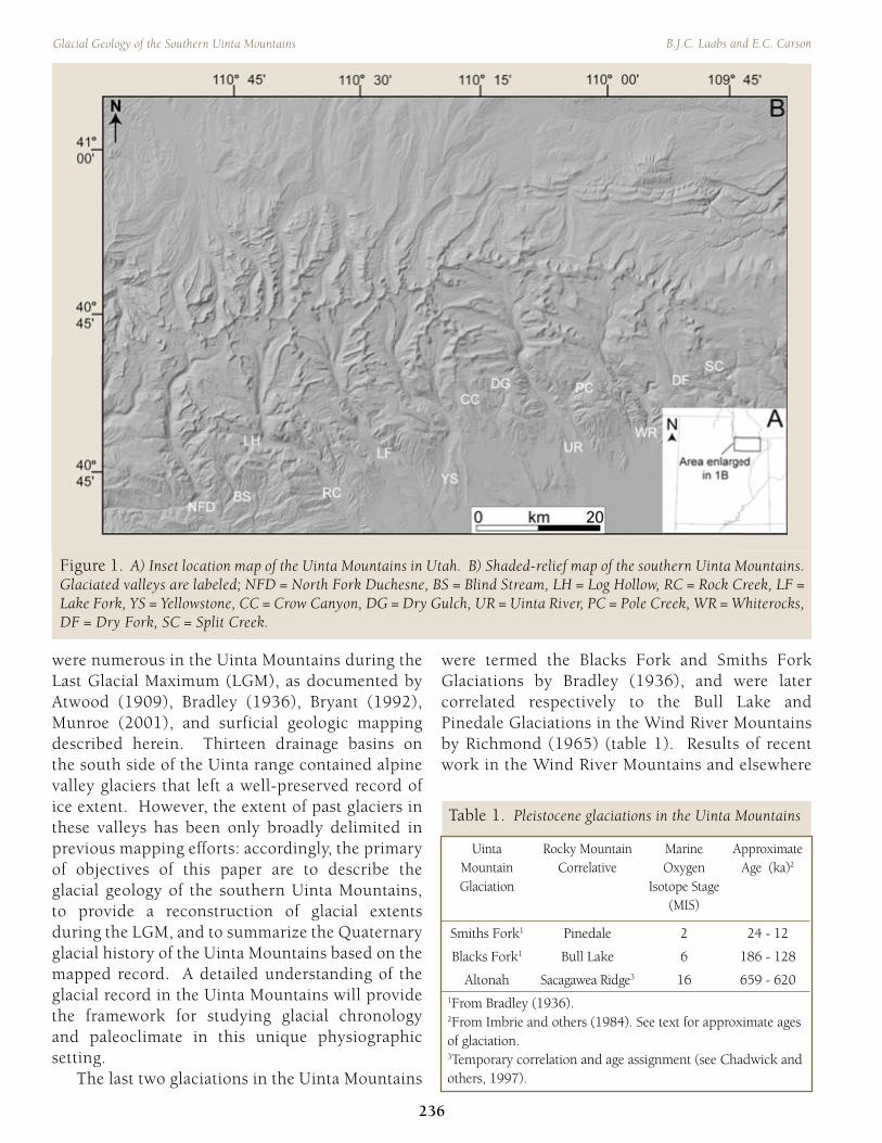
were numerous in the Uinta Mountains during the Last Glacial Maximum (LGM), as documented by Atwood (1909), Bradley (1936), Bryant (1992), Munroe (2001), and surficial geologic mapping described herein. Thirteen drainage basins on the south side of the Uinta range contained alpine valley glaciers that left a well-preserved record of ice extent. However, the extent of past glaciers in these valleys has been only broadly delimited in previous mapping efforts: accordingly, the primary of objectives of this paper are to describe the glacial geology of the southern Uinta Mountains, to provide a reconstruction of glacial extents during the LGM, and to summarize the Quaternary glacial history of the Uinta Mountains based on the mapped record. A detailed understanding of the glacial record in the Uinta Mountains will provide the framework for studying glacial chronology and paleoclimate in this unique physiographic setting. The last two glaciations in the Uinta Mountains
were termed the Blacks Fork and Smiths Fork Glaciations by Bradley (1936), and were later correlated respectively to the Bull Lake and Pinedale Glaciations in the Wind River Mountains by Richmond (1965) (table 1). Results of recent work in the Wind River Mountains and elsewhere
236
Glacial Geology of the Southern Uinta Mountains B.J.C. Laabs and E.C. Carson
Figure 1. A) Inset location map of the Uinta Mountains in Utah. B) Shaded-relief map of the southern Uinta Mountains. Glaciated valleys are labeled; NFD = North Fork Duchesne, BS = Blind Stream, LH = Log Hollow, RC = Rock Creek, LF = Lake Fork, YS = Yellowstone, CC = Crow Canyon, DG = Dry Gulch, UR = Uinta River, PC = Pole Creek, WR = Whiterocks, DF = Dry Fork, SC = Split Creek.
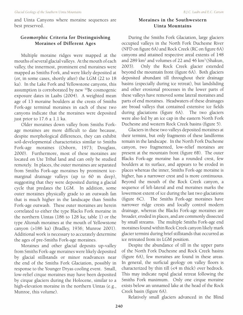
Table 1. Pleistocene glaciations in the Uinta Mountains
Uinta Mountain Glaciation
Rocky MountainCorrelative
Marine Oxygen
Isotope Stage (MIS)
Approximate Age (ka)2
Smiths Fork1 Pinedale 2 24 - 12
Blacks Fork1 Bull Lake 6 186 - 128
Altonah Sacagawea Ridge3 16 659 - 6201From Bradley (1936).2From Imbrie and others (1984). See text for approximate ages of glaciation.3Temporary correlation and age assignment (see Chadwick and others, 1997).

in the Rocky Mountains demonstrates that these glacial cycles occurred during marine oxygen-isotope stage (MIS) 6 (186 to 128 ka; Imbrie and others, 1984) and MIS 2 (24 to 12 ka; Imbrie and others, 1984), respectively. Glacial maxima during MIS 6 occurred at ~160 ka in the nearby Wind River Mountains (Sharp and others, 2003) and at 23 to 16 ka in the Wind Rivers, the Yellowstone Plateau, and the Colorado Rockies during MIS 2 (Gosse and others, 1995; Licciardi and others, 2004; Benson and others, 2004b). Based on cosmogenic 10Be surface-exposure dating of moraine boulders, Laabs (2004) found that the Smiths Fork maximum occurred prior to 17.6 ± 1.1 ka in the south-central Uinta Mountains, which confirms the correlation of the Smiths Fork and Pinedale moraines. For the purpose of this paper, we use the correlations of Richmond (1965); at least until direct dating of Blacks Fork-age deposits is established.
METHODS The geomorphology of the south flank of the Uinta Mountains was mapped at the 1:24,000 scale on 25 U.S.G.S topographic maps and digital elevation models. Surficial deposits and landforms were first identified and delineated on maps and air photos. Then, glacial deposits and landforms were field checked in most accessible areas, but some features were identified only on maps and aerial photographs. Ice extents were interpreted from end moraines at the mouths of glacial valleys, by lateral moraines and trimlines on valley sides, and by breaks in slope on cirque headwalls (i.e., the uppermost ice extent was considered to have been below the points where the slope angle on the cirque headwall exceeds 60°; Meierding, 1982). Areal extent of ice during past glaciations was calculated in a geographic information system. Maximum ice thicknesses were estimated using the differences in elevation of the lateral moraine surface and the valley floor at locations of paleo-equilibrium lines; the latter were estimated by Shakun (2003) based on the accumulation area ratio, toe-headwall altitude ratio, lateral-moraine elevation, and cirque-floor elevation methods.
RESULTS OF GLACIAL MAPPING
Glacial Erosional Landforms U-shaped valleys resulting from broadening of preexisting valleys by alpine glaciers are ubiquitous in the glaciated part of the southern Uinta Mountains (fi gure 1). Glaciers in tributary valleys of major drainage basins coalesced and advanced into U-shaped, trunk valleys. The widest U-shaped valley in the southern Uintas is in the Rock Creek drainage basin, where the horizontal distance between trimlines on valleys sides exceeds 3 km. Whereas streams in many glacial valleys have subsequently smoothed their long profi les by downcutting into bedrock, some tributary streams still exhibit a glacial staircase or step-down topography common to alpine glacial valleys (fi gure 2). Hanging valleys are common in the southern Uinta Mountains where tributary valleys intersect
2005 Utah Geological Association Publication 33
237
Dehler, Pederson, Sprinkel, and Kowallis, editors
Figure 2. Step-down topography near the head of the North Fork Duchesne canyon. Dashed line indicates ice extent during the last glaciation. Arrows indicate former ice flow directions. Topographic map is a portion of the U.S. Geological Survey Mirror Lake 7.5-minute quadrangle.

more deeply eroded trunk valleys. Several glaciated hanging valleys in this area are very broad; for example, Brown Duck basin is more than 12 km wide above Lake Fork canyon (fi gure 3). Such valleys must have contained many small glaciers at the onset of past glaciations that ultimately coalesced before joining larger glaciers during ice advance. The mouths of some hanging valleys are characterized by waterfalls in tributaries, whereas others have deep, narrow, bedrock gorges probably cut by streams of glacial meltwater during deglaciations. In the southern Uintas, the highest cascading waterfalls below hanging valleys are ~300 m at Bluebell Creek in Uinta River canyon and ~350 m at Atwine Creek in Lake Fork canyon (fi gure 3).
Cirques are very common at the heads of glacial valleys in the southern Uintas. Cirque basins are cut into sedimentary rocks of the Proterozoic Uinta Mountain Group and generally contain lakes (or tarns), some of which are dammed by moraines on their down-valley sides. The deepest tarn in the southern Uinta Mountains is Crater Lake (35 m deep; Probst and others, 2000), located in a cirque basin at the head of Lake Fork canyon. Arêtes and cols are most common in the south-central and southwestern Uinta Mountains, where
accumulation areas of glaciers were largest and the development of ice caps that drained into multiple valleys was common. In the south-central Uintas, the most prominent arêtes have more than 450 m of relief and are more than 10 km in length. In the southeastern Uintas, rounded unglaciated divides locally termed “bollies” are more common than narrow arêtes. Examples of these features include broad divides that separate glacial valleys in the headwaters of Dry Fork and Ashley Creeks (fi gure 4). A col is an area of low-elevation at the summit (a French term for “mountain pass”); these are found at the heads of many valleys in the southern Uintas. They vary from narrow divides to broad, till-mantled benches with small, lake-fi lled depressions (fi gure 5).
Glacial Deposits Most glacial deposits in the Uinta Mountains are characterized as diamictons – unstratifi ed, unsorted sediment ranging in size from fi ne sand to large boulders. Silt and clay are not abundant in most glacial diamicton in the Uintas because the dominant sources of this material are coarse-grained clastic sedimentary rocks of the Uinta Mountain
238
Glacial Geology of the Southern Uinta Mountains B.J.C. Laabs and E.C. Carson
Figure 3. Brown Duck Basin, a hanging valley in Lake Fork basin. Dashed line indicates ice extent during the last glaciation. Arrows show former ice flow directions. Cascading waterfalls (CW) above the Lake Fork River (LFR) are up to 350 m high. Topographic map is a portion of the U.S. Geological Survey Kings Peak 15-minute quadrangle.
Figure 4. Broad divides (or “bollies”) between Whiterocks (WR) and Dry Fork (DF) basins. Dashed lines indicate ice extent during the last glaciation (ice extent in valleys adjacent to WR and DF is not shown). Arrows indicate former ice-flow directions. Topographic map is a portion of the U.S. Geological Survey Dutch John 15-minute quadrangle.

Group (although shales are present in the Uinta Mountain Group). Diamictons deposited by trunk valley glaciers are generally matrix supported with 20 to 50% clasts, and tend to be coarser-grained at high elevations where the transport distance by glacier ice was less. The dominant clast size is highly variable and dependent on the source rock in the Uinta Mountain Group. Cobbles and boulders of sandstone and orthoquartzite of the Uinta Mountain Group are the dominant clasts in glacial diamicton in the southern Uinta Mountains except in the Log Hollow and Blind Stream basins (see fi gure 1), where cobbles of Paleozoic sedimentary rocks are dominant. Diamicton deposited directly by glacier ice is called till. Basal and supraglacial till were identifi ed in the southern Uinta Mountains. These are distinguished by differences in their sedimentary properties, their relative degree of compaction, and the types of landforms they comprise. Basal till is composed of sandy diamicton with 20 to 40% clasts ranging in size from pebbles to small boulders. Clast size generally decreases downvalley, and clasts are generally subangular or subrounded with striated surfaces. Supraglacial diamicton is much more variable in texture. Its grain-size distribution can be very similar to basal till, but it generally contains a greater abundance of large, angular clasts that are
not striated and it is less compact than basal till.
Outwash Glacial-fl uvial sand and gravel (outwash) is very common on valley fl oors downstream of moraines. Outwash deposits are most extensive south of moraines at the mouths of Lake Fork, Yellowstone, Uinta, and Whiterocks canyons (see fi gure 1 for locations), where outwash fans grade into outwash terraces. In most valleys, Smiths Fork-, Blacks Fork- and pre-Blacks Fork-age terraces are 5 to 12 m, 25 to 45 m, and up to 125 m above modern stream level, respectively. Outwash is composed of unconsolidated, moderately to well-sorted, stratifi ed deposits of sand and gravel containing well-rounded sandstone and orthoquartzite clasts and Paleozoic limestone locally. Sand lenses and clast-supported gravel bodies are common, with coarser-grained bodies more commonly found at the heads of outwash fans. Clasts are locally coated with secondary carbonate in older outwash deposits and in deposits rich in primary carbonate derived from Paleozoic sedimentary rocks. Nelson and Osborn (1991) also mapped outwash deposits over a broad area of the piedmont south of the Uinta Mountains in the Uinta Basin, whereas our mapping focused on deposits in the vicinity of glacial termini. They provide a more detailed description of outwash terraces and correlated several Pleistocene terraces across the south-central Uintas and assigned ages to terraces based on soil-development indices.
MORAINE SEQUENCES IN THE SOUTHERN UINTA MOUNTAINS
Moraine ridges deposited during the past two or more glaciations are well preserved in several glacial valleys in the southern Uintas. Narrow, latero-frontal moraines are common at the mouths of the largest glacial valleys as ridges up to 80 m high and >11 km long. Stagnant-ice deposits are found at the mouths of smaller canyons where ice deposited broad areas of hummocky topography. Small, low-relief recessional moraines are located up-valley from prominent terminal moraines and were deposited during overall glacier retreat. This section describes the moraine record in the southern Uinta Mountains, focusing on the Lake Fork, Yellowstone,
2005 Utah Geological Association Publication 33
239
Dehler, Pederson, Sprinkel, and Kowallis, editors
Figure 5. Broad upland at the divide between North Fork Duchesne (NFD) and Rock Creek (RC) basins. Dashed lines indicate ice extent during the last glaciation; solid black line is the present drainage divide and approximates the location of the former ice divide between the basins. Arrows indicate former ice flow directions. Topographic map is a portion of the U.S. Geological Survey Kings Peak 15-minute quadrangle.
and Uinta Canyons where moraine sequences are best preserved.
Geomorphic Criteria for Distinguishing Moraines of Different Ages
Multiple moraine ridges were mapped at the mouths of several glacial valleys. At the mouth of each valley, the innermost, prominent end moraines were mapped as Smiths Fork, and were likely deposited at (or, in some cases, shortly after) the LGM (22 to 18 ka). In the Lake Fork and Yellowstone canyons, this assumption is corroborated by new 10Be cosmogenic exposure dates in Laabs (2004). A weighted mean age of 13 moraine boulders at the crests of Smiths Fork-age terminal moraines in each of these two canyons indicate that the moraines were deposited just prior to 17.6 ± 1.1 ka. Older moraines down valley from Smiths Fork-age moraines are more diffi cult to date because, despite morphological differences, they can exhibit soil-developmental characteristics similar to Smiths Fork-age moraines (Osborn, 1973; Douglass, 2000). Furthermore, most of these moraines are located on Ute Tribal land and can only be studied remotely. In places, the outer moraines are separated from Smiths Fork-age moraines by prominent ice-marginal drainage valleys (up to 60 m deep), suggesting that they were deposited during a glacial cycle that predates the LGM. In addition, some outer moraines physically grade to an outwash fan that is much higher in the landscape than Smiths Fork-age outwash. These outer moraines are herein correlated to either the type Blacks Fork moraine in the northern Uintas (186 to 128 ka; table 1) or the type Altonah moraines at the mouth of Yellowstone canyon (>186 ka) (Bradley, 1936; Munroe 2001). Additional work is necessary to accurately determine the ages of pre-Smiths Fork-age moraines. Moraines and other glacial deposits up-valley from Smiths Fork-age moraines were likely deposited by glacial stillstands or minor readvances near the end of the Smiths Fork Glaciation, possibly in response to the Younger Dryas cooling event. Small, low-relief cirque moraines may have been deposited by cirque glaciers during the Holocene, similar to a high-elevation moraine in the northern Uintas (e.g., Munroe, this volume).
Moraines in the Southwestern Uinta Mountains
During the Smiths Fork Glaciation, large glaciers occupied valleys in the North Fork Duchesne River (NFD on fi gure 6A) and Rock Creek (RC on fi gure 6A) canyons and attained respective areal extents of 148 and 289 km2 and volumes of 22 and 46 km3 (Shakun, 2003). Only the Rock Creek glacier extended beyond the mountain front (fi gure 6A). Both glaciers deposited abundant till throughout their drainage basins (especially during ice retreat), but landsliding and other erosional processes in the lower parts of these valleys have removed some lateral moraines and parts of end moraines. Headwaters of these drainages are broad valleys that contained extensive ice fi elds during glaciations (fi gure 6A). The two glaciers were also fed by an ice cap in the eastern North Fork Duchesne and western Rock Creek basins (fi gure 5). Glaciers in these two valleys deposited moraines at their termini, but only fragments of these landforms remain in the landscape. In the North Fork Duchesne canyon, two fragmented, low-relief moraines are present at the mountain front (fi gure 6B). The outer Blacks Fork-age moraine has a rounded crest, few boulders at its surface, and appears to be eroded in places whereas the inner, Smiths Fork-age moraine is higher, has a narrower crest and is more continuous. Beyond the mouth of the Rock Creek canyon, a sequence of left-lateral and end moraines marks the lowermost extent of ice during the last two glaciations (fi gure 6C). The Smiths Fork-age moraines have narrower ridge crests and locally control modern drainage, whereas the Blacks Fork-age moraines are broader, eroded in places, and are commonly dissected by small streams. The multiple Smiths Fork-age end moraines found within Rock Creek canyon likely mark glacier termini during brief stillstands that occurred as ice retreated from its LGM position. Despite the abundance of till in the upper parts of the North Fork Duchesne and Rock Creek basins (fi gure 6A), few moraines are found in these areas. In general, the surfi cial geology on valley fl oors is characterized by thin till (<4 m thick) over bedrock. This may indicate rapid glacial retreat following the Smiths Fork maximum. Only one cirque moraine exists below an unnamed lake at the head of the Rock Creek basin (fi gure 6A). Relatively small glaciers advanced in the Blind
240
Glacial Geology of the Southern Uinta Mountains B.J.C. Laabs and E.C. Carson

Stream (BS on fi gure 6A) and Log Hollow (LH on fi gure 6A) basins and attained respective areal extents of 16 and 8 km2 during the LGM. Both glaciers deposited abundant till throughout their basins; however, due to widespread landsliding in the Blind Stream basin, only fragments of moraine ridges are preserved, whereas moraines in Log Hollow are well preserved throughout the basin (fi gure 6A). Details on the glacial geology of these two basins are in Laabs (2004).
Moraines in the South-Central Uinta Mountains
Valley glaciers fi lled the Lake Fork (LF in fi gure 7A), Yellowstone (YS in fi gure 7A), and Uinta River (UR in fi gure 7A) canyons during middle and late Quaternary glaciations. In each of these basins, large glaciers coalesced from broad ice fi elds at the valley
heads and advanced beyond the mountain front, depositing the best-preserved sequences of latero-frontal moraines in the southern Uinta Mountains (fi gure 7A). The glacial record in each of these basins includes moraines from three glaciations; the Smiths Fork and Blacks Fork Glaciations are represented along with the older Altonah Glaciation. Well preserved outwash fans and terraces have clear relationships with terminal moraines from three glaciations and have heights up to 125 m above modern stream level.
Lake Fork Canyon
In Lake Fork canyon, the wide valley mouth is split by a bedrock knob in its center. The Lake Fork River fl ows on the east side of this knob, allowing for excellent preservation of moraines on the western side of the valley (fi gure 7B). Terminal moraines
2005 Utah Geological Association Publication 33
241
Dehler, Pederson, Sprinkel, and Kowallis, editors
Figure 6. (A) Mapped glacial deposits superimposed on shaded relief in the southwestern Uintas. (B) Glacial geology at the mouths of North Fork Duchesne (NFD) canyon and (C) Rock Creek (RC) canyon. Boxes indicate areas shown in Figure 6B and C. Topographic maps are portions of the Kings Peak and Duchesne 15-minute quadrangles (B) and the 7.5-minute Hanna quadrangle (C). North is up on all figures. See figure 1 caption for explanation of abbreviations.
242
Glacial Geology of the Southern Uinta Mountains B.J.C. Laabs and E.C. Carson
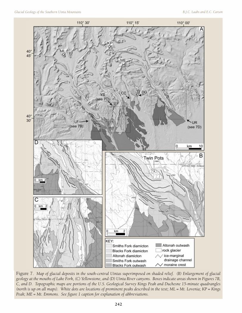
Figure 7. Map of glacial deposits in the south-central Uintas superimposed on shaded relief. (B) Enlargement of glacial geology at the mouths of Lake Fork, (C) Yellowstone, and (D) Uinta River canyons. Boxes indicate areas shown in Figures 7B, C, and D. Topographic maps are portions of the U.S. Geological Survey Kings Peak and Duchesne 15-minute quadrangles (north is up on all maps). White dots are locations of prominent peaks described in the text; ML = Mt. Lovenia; KP = Kings Peak; ME = Mt. Emmons. See fi gure 1 caption for explanation of abbreviations.

are separated by narrow, continuous ice-marginal drainage valleys up to 60 m deep. Smiths Fork and Blacks Fork-age moraines are compound in places, in which individual ridges have narrow crests with up to 50 m of relief (Smiths Fork-age moraines generally have greater heights). An outwash fan originates from the distal edge of the Smiths Fork moraine and grades into a terrace that is 5 to 12 m above the Lake Fork River (fi gure 7B). Another outwash fan originates from the Blacks Fork moraine and grades into a much higher terrace that is >20 m above the Smiths Fork-age terrace. Recessional moraines are numerous in Lake Fork canyon and delimit ice margins during overall retreat near the end of the last glaciation. Most notable of these is a 5-m-high, continuous latero-frontal moraine that dams the south end of Twin Pots Reservoir (fi gure 7B). The outer, Altonah-age moraines are broad, up to ~50 m high, and appear to be more eroded and dissected by gullies than the Blacks Fork- and Smiths Fork-age moraines. The outwash terrace extending from the Altonah-age moraines is >20 m above the Blacks Fork-age outwash terrace and ~50 m above modern grade.
Yellowstone Canyon
Moraines at the mouth of Yellowstone canyon are also well preserved, and a sequence of lateral moraines separated by deep, ice-marginal drainage valleys is most prominent (fi gure 7C). The Smiths Fork moraines have >70 m of relief and form the most extensive latero-frontal ridge in the sequence (fi gure 8A). The outwash terrace that originates at the outermost Smiths Fork moraine is 5 to 12 m above the Lake Fork River (below the confl uence of the Yellowstone and Lake Fork). Blacks Fork moraines at the mouth of Yellowstone canyon have broader and more rounded crests and up to ~60 m of relief; an outwash terrace that originates from the end moraine is 15 to 20 m higher than the Smiths Fork-age terrace (fi gure 7B). Between the Yellowstone and Lake Fork valleys, a broad area of hummocky topography was deposited likely during the Blacks Fork Glaciation while glaciers in each of these valleys attained maxima on the piedmont (fi gure 8B). Moraines in Yellowstone valley that represent the Altonah Glaciation are
split into two distinct units. The Altonah I moraine is a broad, eroded, low-relief ridge whereas the Altonah II moraine is a narrow, continuous ridge with up to ~90 m of relief and appears to be eroded at the surface and on hillslopes. The soil in this moraine exhibits stage-III carbonate development, suggesting that it may be middle-Pleistocene in age (Nelson and Osborn, 1991). This is consistent with a correlation of this moraine to the Sacagawea moraine in the Wind River Mountains (Chadwick and others, 1997). An extensive sequence of recessional moraines and kame terraces is located on the sides of Yellowstone canyon up-valley from the Smiths Fork terminal moraine. These features mark the
2005 Utah Geological Association Publication 33
243
Dehler, Pederson, Sprinkel, and Kowallis, editors
Figure 8. Moraines in the south-central Uinta Mountains. A) Southward view of a sequence of lateral moraines deposited during the Smiths Fork (SF) and Blacks Fork (BF) Glaciations. Low-relief ridges in the foreground are Smiths Fork recessional moraines (SFR) and fl at surfaces on the valley bottom are outwash deposits. B) An area of hummocky topography (indicated by boxed area) deposited at the mountain front by glaciers in the Lake Fork (LF) and Yellowstone (YS) drainages during the Blacks Fork. Flat surfaces on the valley bottom are outwash deposits.

position of the glacier margin as it retreated after 17.6 ± 1.1 ka (Laabs, 2004). The moraines have <6 m of relief, are fragmented, and are breached in places by modern stream channels (see fi gure 9). Kame terraces represent deposition of moderately to poorly sorted silty sand and gravel in water fl owing between the lateral moraine or ice margin and the valley side. They are distinguished from fl uvial terraces by their association with lateral moraines and their steep gradients that mimic former slope of the ice-surface rather than gentler stream gradients. Three cirque moraines are found near the head of Yellowstone basin (fi gure 7A); the most prominent of these is a broad, hummocky ridge that dams North Star Lake. Another broad, discontinuous, bouldery right-lateral moraine dams Doll Lake. The third is a low-relief, bouldery, narrow ridge located a few km west of Kings Peak.
Uinta River Canyon
A moraine sequence similar to those described above is found at the mouth of the Uinta River canyon (fi gure 7D). In this area, lateral moraines are well preserved, but end moraines have been eroded by the Uinta River, which drains the second largest basin in the southern Uintas (after Rock Creek basin). The most extensive moraines at the mouth of Uinta River canyon are up to 120 m high and are interpreted to represent deposition during the Blacks Fork Glaciation based on the height of an associated outwash terrace >24 m above the Uinta River. Finally, the outermost moraine on the west side of Uinta River canyon is a broad area of low-relief hummocky topography separated from the Blacks Fork-age moraine by a 50-m-deep ice-marginal drainage valley; we interpret this feature to represent deposition during the Altonah Glaciation. At least three cirque moraines are found in the upper part of the Uinta River basin; the most prominent of these are near Mount Emmons (fi gure 7A). A low-relief, rounded moraine ridge is located below Oke Doke Lake east of Mount Emmons and a double-crested, hummocky moraine is found in a cirque south of Mount Emmons. As in other basins, these moraines were likely deposited during overall retreat at the end of the Smiths Fork Glaciation.
Crow Canyon and Dry Gulch
Two glaciers fi lled small valleys carved into a broad upland between Yellowstone and Uinta River canyons during the past two glaciations (fi gure 7A). The larger of these two glaciers occupied Crow Canyon (CC on fi gure 7A), where ice advanced approximately 11 km from a broad cirque during the Smiths Fork Glaciation. Smiths Fork-age lateral moraines on the valley sides give way to a broad (1.5 km wide) area of hummocky topography and abundant, small kettle lakes. This area is divided into Smiths Fork and Blacks Fork-age deposits based on morphological differences, where younger deposits have higher internal relief and more abundant lakes. The Dry Gulch glacier deposited a sequence of narrow-crested moraine ridges with up to 60 m of relief. The outermost moraine was likely deposited during the Smiths Fork maximum and inner moraines were deposited during overall retreat. The end moraine labeled “DG2” in fi gure 10 has been breached at its down-valley end. Radiocarbon dating of wood deposited during the failure indicates that the moraine was likely breached in the past 90 ± 40 years (E. Carson, unpublished data). Subsequent incision of sediments deposited in standing water behind moraine DG2 revealed a record that has provided limiting ages on the timing of deglaciation in this drainage basin. Radiocarbon dating of buried terrestrial and aquatic vegetation along with preliminary diatom analyses of samples from these sediments indicate that it was an open-water pond from deglaciation through the middle Holocene (Carson, 2003). A calendar-year-corrected radiocarbon age for the moraine of 12.9 ± 0.7 ka limits the age of moraines DG2 and DG3 (fi gure 10), where DG2 must be older and DG3 younger than this age. Indeed, DG3 may have been deposited by a glacier advance in response to the Younger Dryas cooling episode (12.8 – 11.5 ka; Alley and others, 1993). Evidence of a glacial response to this event has not been identifi ed elsewhere in the Uinta Mountains, and deglaciation of Dry Gulch signifi cantly post-dates deglaciation from cirque fl oor moraines ~40 km to the east. Munroe (2001) provides a limiting calendar-year-corrected radiocarbon age of >14.5 ka for Ashley Creek, more than 1500 years older than Dry Gulch despite being ~300 m higher than the DG2 moraine.
244
Glacial Geology of the Southern Uinta Mountains B.J.C. Laabs and E.C. Carson

The Southeastern Uinta Mountains
Discrete valley glaciers occupied valleys in the southeastern part of the glaciated Uintas during Quaternary glaciations (fi gure 11A). The largest glacier in this area was in the Whiterocks (WR in fi gure 11A) basin, where ice fi elds fi lled broad headwater valleys and coalesced before advancing beyond the mountain front. The composite moraine at the mouth of Whiterocks canyon has been eroded by the Whiterocks River and may have been partially removed by mass wasting. Only right-lateral moraines of the Blacks Fork and Smiths Fork Glaciations are preserved (fi gure 11A). Glaciers in the Dry Fork (DF in fi gure 11A), Pole Creek (PC in fi gure 11A) and Split Creek (SC in fi gure 11A) valleys were smaller and confi ned in canyons. End moraines deposited in these valleys during the last glaciation are small but well preserved. The Smiths Fork-age moraine at the mouth of Whiterocks canyon is a composite ridge with up to 60 m of relief (fi gure 11B). Individual ridges are discontinuous and have either sharp or rounded crests with abundant small boulders at their surfaces. The lowest part of this moraine is below 2075 m asl, the lowest elevation attained by Smiths Fork-age moraines in the southern Uinta Mountains. A broad outwash fan originates at this moraine and grades into a terrace that is <12 m above the Whiterocks River near the moraine and ~5 m above the river downstream. The outermost moraine in this area is a composite ridge that was most likely deposited during the Blacks Fork Glaciation. A sequence of recessional, lateral moraines is preserved in the northeast part of Whiterocks basin (fi gure 11). These
ridges are up to 4 m high, and are composed mainly of large, angular boulders. Small cirque moraines are found below Chepeta and Taylor Lakes (fi gure 12). A sequence of end moraines deposited during the last glaciation are confi ned to the Dry Fork canyon; outwash extends eastward from these moraines and forms a terrace that is generally <5 m above the Dry Fork Creek. Broad lateral moraines mark the outer edge of the Dry Fork glacier where it overtopped the canyon at Hen Lee Bench and Horseshoe Park. These moraines have hummocky surfaces and many kettle lakes, the largest of which is Dead Lake near Paradise Reservoir. A large landslide in lower Dry
2005 Utah Geological Association Publication 33
245
Dehler, Pederson, Sprinkel, and Kowallis, editors
Figure 9. Right-lateral recessional moraines near the mouth of Yellowstone canyon. Black dashed lines mark ridge crests. Former ice-flow direction was right to left. Arrow points to the outermost Smiths Fork-age moraine.
Figure 10. A) Sequence of Smiths Fork-age moraines in Dry Gulch (DG) basin. DG1 = darkest gray, DG2 = medium gray, DG3 = lightest gray. Solid line shows the location of cross-section in figure 9B. Topographic map is a portion of the U.S. Geological Survey Heller Lake and Burnt Mill Spring 7.5-minute quadrangles. B) Schematic cross section of moraines DG2 and DG3. See text for explanation of the limiting radiocarbon age of moraines DG2 and DG3.

Fork canyon occurred in 1997 and removed part of a Smiths Fork lateral moraine. This landslide occurred during spring snowmelt and may have been related to saturation of glacial till and underlying sediment by subsurface seepage from an irrigation canal, part of which was constructed in an ice-marginal drainage channel (fi gure 13).
Comparison with Previous Mapping
In the earliest report on the glacial geology of the Uinta Mountains, Atwood (1909) noted that moraine sequences in the southern Uintas represented deposition during two glaciations, which he termed “earlier” and “later epochs” (Atwood, 1909). His map shows moraines of the “earlier epoch” extending beyond the mountain front in most areas and moraines of the
246
Glacial Geology of the Southern Uinta Mountains B.J.C. Laabs and E.C. Carson
Figure 11. A) Map of glacial deposits superimposed on shaded relief in the southeastern Uintas. B) Enlarged map of glacial geology at the mouths of Whiterocks canyon and (C) Dry Fork canyon. Boxes indicate areas shown in figure 10B and C. Topographic maps are portions of the Dutch John 15-minute quadrangle. North is up on all maps. See figure 1 caption for explanations of abbreviations.
Figure 12. Cirque moraine impounding Taylor Lake (a tarn) in the headwaters of the Whiterocks basin. Former ice-flow direction was from right to left. Photo by J. Munroe.

“later epoch” confi ned within mountain valleys. Our mapping results differ in that we believe ice extent in most valleys was similar during the past two glaciations based on the relative ages of moraines at the mouths of glacial canyons (see fi gures 6, 7, and 10). Atwood (1909) mapped several moraines confi ned to canyons in the southern Uinta Mountains that were either not identifi ed in this study or were mapped as recessional moraines of the Smiths Fork Glaciation. Osborn (1973) mapped moraine sequences in Yellowstone, Crow Canyon, Dry Gulch, and Uinta River basins, subdividing moraines on the basis of morphology and relative soil development. He documented evidence for 8 Pleistocene glacial advances; 3 pre-Blacks Fork in age, 2 Blacks Fork or early Smiths Fork, and 3 Smiths Fork in age. Our age designations generally agree with those of Osborn (1973); however, we argue that Smiths Fork recessional moraines do not necessarily justify designation as separate glacial advances, but could instead represent brief glacial stillstands or minor oscillations during overall retreat. For Smiths Fork-age moraines, this is supported by cosmogenic 10Be boulder-exposure ages that also corroborate our interpretation that the inner moraine at the mountain front is Smiths Fork in age (~17.6 ka; Laabs, 2004).
DISCUSSION – THE PATTERN OF GLACIATION
During the LGM, glaciers covered ~1460 km2 in the southern Uinta Mountains, with the largest glaciers advancing in the central part of the glaciated area (table 2; plate 1 - on cd only). Ice caps that fed adjacent glaciers were largest between North Fork Duchesne and Rock Creek glaciers, but were relatively small or absent elsewhere. Interestingly, the total area of ice cover was ~500 km2 greater in the southern Uintas than in the northern Uintas, and glaciers in Rock Creek and Uinta River canyons were larger than any glacier in the northern Uintas (Munroe, 2001; fi gure 14; explanations for this unexpected result are offered below). The thickest glaciers were in the western Uintas, where broad ice fi elds drained into the North Fork Duchesne and Rock Creek canyons. The widest glacier was in Dry Fork valley where ice overtopped the shallow canyon and deposited hummocky, lateral moraines. Equilibrium-line altitudes (ELAs) generally rose from west to east during the LGM, likely due to enhanced winter precipitation in western valleys compared to those in the east (Munroe and Mickelson, 2002; Shakun, 2003; table 2). The east-
2005 Utah Geological Association Publication 33
247
Dehler, Pederson, Sprinkel, and Kowallis, editors
Mean Max Mean Max Accum.
Perimeter Length Area High Low Thickness Thickness Width Width ELA2 Area
Glacier (km) (km) (km1) (m asl) (m asl) (m) (m) (m) (m) (m asl) (km1)
N.F. Duchesne (NFD) 153.0 33.4 153.5 3580 2159 286 494 1687 2825 2920 111.9
Blind Stream (BS) 34.2 11.7 21.6 3367 2297 120 182 1015 2697 2950 17.4
Log Hollow (LH) 25.7 9.1 8.0 3311 2573 40 78 838 1047 2970 4.7
Rock Creek (RC) 237.4 42.8 288.7 359.5 2132 286 495 2390 3474 3010 223.2
Lake Fork (LF) 206.9 35.7 231.9 3692 2256 278 434 2490 3497 3040 173.4
Yellowstone (YS) 190.9 41.3 213.5 3807 2264 255 391 2585 3360 3070 151.9
Crow Canyon (CC) 29.4 11.8 17.7 3538 2756 91 194 1275 1785 3090 9.7
Dry Gulch (DG) 19.8 8.5 7.6 3341 2732 38 54 928 1047 3040 4.0
Uinta (UR) 264.0 43.0 256.8 3852 2201 281 431 2250 3099 3100 204.1
Pole Creek (PC) 25.7 10.5 18.4 3428 2785 81 133 1357 3127 3070 12.9
Whiterocks (WR) 149.9 35.9 161.5 3651 2098 229 321 1906 4070 3090 122.4
Dry Fork (DF) 80.9 22.5 79.3 3467 2488 183 283 1657 4185 3060 62.5
Spit Creek (SC) 9.2 4 3.5 3343 3000 39 66 897 992 3120 1.5
Mean 109.8 23.9 112.5 3536 2442 170 274 1637 2708 3041 85
Stand. Dev. 93.5 15.1 108.6 180 299 104 – 641 – 62 832From Shakun, 2003
Table 2. Properties of reconstructed glaciers in the southern Uinta Mountains.

west ELA gradient across the southern Uintas is steeper than the regional gradient across the western United States from the Cascades to the Colorado Rockies (e.g., Pierce, 2004). This may refl ect the importance of Lake Bonneville as a moisture source for glaciers in the western Uintas (Munroe and Mickelson, 2002; Munroe, this volume). Reconstructions of the Smiths Fork glaciation indicate that the largest glaciers were in the south-central Uintas (fi gure 14). One explanation for this phenomenon is that accumulation areas were simply larger in this part of the range. Indeed, the highest part of the Uintas is in the south-central part of the glaciated area and roughly coincides with the domal center of the Uinta Mountain anticline. The seven largest glaciers in the southern Uintas surround this area and had similar hypsometries to each other (fi gure 15), where at least 65% of the accumulation area was above the equilibrium line. Thus, the sizes of their accumulation areas can explain which glaciers were largest (table 2). The large surface area above LGM ELAs may also explain why the total area of ice cover in the southern Uintas was greater than in the north (fi gure 14). Atwood (1909) fi rst recognized that gentler bedrock dips on the south fl ank may have driven glaciers to erode laterally more easily than on the north fl ank, leading to the development of broad valleys at the heads of
basins. Gently dipping bedrock at the domal center of the Uinta Mountain Arch (fi gure 14) may also explain why greater surface areas of such tributaries are above LGM ELAs than in the northern Uintas, thereby increasing the size of accumulation areas (and ultimately the size of glaciers) in the southern Uintas. Although differences in local climate in the Uintas may also explain the pattern of glaciation, it seems likely that bedrock structure and its effect on valley-fl oor elevations in the Uintas may have been a major infl uence. Bedrock also infl uenced the style of glacial deposition in other valleys. In most valleys, glaciers deposited narrow, high-relief latero-frontal moraines, but glaciers in Crow Canyon and Split Creek valleys deposited broad, hummocky end moraines. In both of these small catchments, fl at uplands are covered by Pliocene- to Pleistocene-age gravels documented by Sprinkel (2002) that are the source of abundant mass wasting deposits elsewhere in the Uintas (Laabs, 2004). Headward erosion of this unit by the Crow Canyon glacier may have caused landsliding of debris onto the ice surface that was transported to the ablation zone, where it would have blanketed ice. This may have led to deposition of a broad area of hummocky topography rather than a narrow end moraine. Weakly-cemented shale of the Uinta Mountain Group outcrops at the head of Split Creek valley, which may have similarly led to deposition of hummocky end moraines. In the Dry Fork basin, weakly-cemented Pliocene to Pleistocene-age gravels may have partly controlled the pattern of glacial advance. In most valleys in the southern Uintas, broad, U-shaped valleys were carved into Proterozoic and Paleozoic strata during glacial cycles and were only partially fi lled in by glacial or alluvial sediment between glacial maxima. The setting in lower Dry Fork canyon is different, however, in that loose, Pliocene to Pleistocene-age gravel in the canyon has persisted through Quaternary glaciations and still outcrops on the west side of the canyon. These rocks have been the source of abundant post-glacial mass wasting (including the 1997 landslide mentioned above), possibly due to oversteepening by lateral glacial erosion and buttressing by glacier ice. Abundant mass wasting and rapid erosion of the gravel during the Holocene has partly fi lled in the canyon and obscured the effects of glacial erosion, resulting in
248
Glacial Geology of the Southern Uinta Mountains B.J.C. Laabs and E.C. Carson
Figure 13. Kettled right and left-lateral moraines in the Dry Fork basin. Dashed lines indicate ice extent during the last glaciation. Solid lines are moraine crests. Shaded area is the location of the 1997 landslide described in the text. Arrow indicates former ice-flow direction. Topographic map is a portion of the U.S. Geological Survey 7.5-minute Paradise Park quadrangle.

a V-shaped canyon in lower Dry Fork (fi gure 16). Nevertheless, lateral moraines above both sides of the canyon indicate that it was once fi lled and overtopped by glacier ice.
SUMMARY OF GLACIAL HISTORY IN THE SOUTHERN UINTA MOUNTAINS
Quaternary deposits and landforms record the history of at least three glacial cycles in the southern Uinta Mountains: the Altonah, Blacks Fork, and Smiths Fork Glaciations. Moraines that represent these events are best preserved at the mouths of canyons in the south-central Uinta Mountains and were deposited by the largest alpine glaciers in the range. Smiths Fork moraines are found in all glacial valleys. Recessional moraines and high-elevation glacial features were deposited at the end of this cycle, during the Younger Dryas cooling event, or possibly during Holocene neoglacial advances (see Munroe, this volume). The Pleistocene glacial
history of the southern Uinta Mountains summarized here is inferred from the characteristics and limited chronology of deposits and landforms described above. Additional dating and ongoing research by the authors and J. Munroe will improve our understanding of latest-Pleistocene (and perhaps Holocene) glacial extent and chronology in the southern Uinta Mountains.
The Altonah Glaciations
Although the ages of these glacial cycles are unknown, they most likely predate MIS 6 and may correlate to the Sacagawea Ridge Glaciation recognized by Richmond (1965). Lateral and end moraines in the Lake Fork, Yellowstone, and Uinta River drainages indicate that these basins and, probably, all of the glacial valleys in the southern Uinta Mountains west of Split Creek were occupied by ice during this cycle. In the south-central Uintas, it is clear that Altonah glaciers advanced beyond the
2005 Utah Geological Association Publication 33
249
Dehler, Pederson, Sprinkel, and Kowallis, editors
Figure 14. Reconstructed ice extents in the northern and southern Uinta Mountains. See Figure 1 for names of drainage basins on the south flank. Dashed line indicates the drainage divide between the north and south flanks. Solid line indicates the hinge of the Uinta Arch (from Bryant, 1992). North slope ice extents are from Munroe (2001).

250
Glacial Geology of the Southern Uinta Mountains B.J.C. Laabs and E.C. Carson
North Fork Duchesne
Cumulative Area (%)
4000
3500
3000
2500
20000 20 40 60 80 100
Ele
vatio
n (m
asl
)
Rock Creek
Cumulative Area (%)
4000
3500
3000
2500
20000 20 40 60 80 100
Ele
vatio
n (m
asl
)
Lake Fork
Cumulative Area (%)
4000
3500
3000
2500
20000 20 40 60 80 100
Ele
vatio
n (m
asl
)
Yellowstone
Cumulative Area (%)
4000
3500
3000
2500
20000 20 40 60 80 100
Ele
vatio
n (m
asl
)
Uinta River
Cumulative Area (%)
4000
3500
3000
2500
20000 20 40 60 80 100
Ele
vatio
n (m
asl
)
Whiterocks
Cumulative Area (%)
3900
3400
2900
2400
19000 20 40 60 80 100
Ele
vatio
n (m
asl
)
Dry Fork
Cumulative Area (%)
4000
3500
3000
2500
20000 20 40 60 80 100
Ele
vatio
n (m
asl
)
ELA = 2920 ELA = 3010
ELA = 3040 ELA = 3070
ELA = 3100 ELA = 3090
ELA = 3060
Figure 15. Reconstructed hypsometry of the seven largest glaciers in the southern Uintas during the Smiths Fork maximum. Solid lines are reconstructed ice-surface elevations. Dashed lines are reconstructed ELAs from Shakun (2003). See figure 1B for locations.

mountain front and extended the furthest down valley of any subsequent glaciation.
The Blacks Fork Glaciation
Evidence of the Blacks Fork Glaciation is widespread throughout the southern Uintas, though none of the Blacks Fork moraines have yet been dated. These moraines most likely correlate with the Bull Lake Glaciation, as first noted by Richmond (1965). During the Blacks Fork Glaciation, ice advanced beyond the mountain front and onto the piedmont in south-central valleys, but was generally confined to canyons in the southwestern and southeastern catchments. The most prominent features that represent this event are latero-frontal moraine loops at the mouths of Lake Fork, Yellowstone, and Uinta River canyons. Moraines representing MIS 4 (71 to 59 ka; Imbrie and others, 1984) are not found in the Uintas or elsewhere in the Rocky Mountains, but recent mapping by Chadwick and others (1997) and numerical dating by Sharp and others
(2003) of an outwash terrace in the Wind River Mountains suggests glaciers may have advanced in the Rocky Mountains during this time. Counts (2005) documented evidence of a MIS 4 terrace in the Henry’s Fork River on the north slope of the Uintas, but similar terraces have not yet been identified in the southern Uintas.
The Smiths Fork Glaciation
Deposits from the last glaciation are the most widespread and best dated in the Uintas. Glaciers reached their maxima prior to 17.6 ± 1.1 ka in the Lake Fork and Yellowstone canyons (Laabs, 2004), and retreated shortly after this time. Glacial stillstands or subsequent readvances occurred in several valleys, as indicated by the presence of recessional moraines in the lower parts of valleys, namely in North Fork Duchesne, Lake Fork, Yellowstone, and Dry Gulch basins. The age of one such advance or stillstand is ~12.9 ka, when a small glacier retreated from a recessional ridge in Dry Gulch basin. In the eastern Uintas, however, valleys were apparently
2005 Utah Geological Association Publication 33
251
Dehler, Pederson, Sprinkel, and Kowallis, editors
Proterozoic bedrock
Pliocene (?)gravel
Smiths Fork diamicton
alluvium
hillslope deposits
Smiths Fork diamicton
SW
Mosby
Mtn Julius
Park
Horseshoe
Parkapproximate former ice surface
A A'
8800
9800
9400
Ele
vatio
n (f
t asl
)
A
A'
NE
Figure 16. Schematic cross section of the geology of lower Dry Fork canyon (note: thickness of geologic units is not to scale). Dashed lines show geologic contacts, gray line shows the approximate ice surface during the Smiths Fork maximum. Hillslope deposits are mainly landslides and slumps in glacial diamicton. Inset map shows cross-section line on the U.S. Geological Survey 15-minute Vernal quadrangle. Elevations are in feet above sea level to follow U.S. Geological Survey 7.5-minute topographic maps.

ice free by ~14 ka (Munroe, 2002). These dates, along with an eastward rise in ELAs, indicate variations in climate across the southern Uintas during the Smiths Fork maximum and during subsequent deglaciation that may be related to the influence of Lake Bonneville on local climate (e.g., Munroe and Mickelson, 2002). Glaciers likely existed in cirques in the high Uintas as late as ~13 ka, and may have advanced in response to the Younger Dryas cooling event and possibly Holocene climate changes.
ACKNOWLEDGMENTS
Funding for this research was provided by the Geological Society of America, the Jonathan Davis Scholarship from the Desert Research Institute at the University of Nevada-Reno, D. Koerner at the Ashley National Forest, and the National Science Foundation (EAR-0345277). J. Shakun, J. Munroe, D. Mickelson, M. Devito, N. Oprandy, J. Silverman, O. Krawciw, N. Laabs, H. Kempenich, Z. Shangze, C. Rodgers, K. Refsnider, and T. Westlund assisted with field studies. Reviews by D. Mickelson, J. Munroe, D. Sprinkel and J. Pederson were extremely helpful in preparing this paper.
REFERENCES
Alley, R.B., Meese, D.A., Shuman, C.A., Gow, A.J., Taylor, K.C., Grootes, P.M., White, J.W.C., Ram, M., Waddington, A.D., Mayewski, P.A., and Zielinski, G.A., 1993, Abrupt increase in Greenland snow accumulation at the end of the Younger Dryas event: Nature, v. 362, p. 527-529.
Atwood, W.W., 1909, Glaciation of the Uinta and Wasatch Mountains: U.S. Geological Survey Professional Paper 61, 96 p.
Benson, L., Madole, R., Phillips, W., Landis, G., Thomas, T, and Kubik, P., 2004a. The probable importance of snow and sediment shielding on cosmogenic ages of the north-central Colorado Pinedale and pre-Pinedale moraines: Quaternary Science Reviews, v. 23, p. 193-206.
Benson, L., Madole, R., Landis, G., and Gosse, J., 2004b, New data for late Pleistocene Pinedale
alpine glaciation from southwestern Colorado: Quaternary Science Reviews, v. 24, p. 49-65.
Bradley, W.A., 1936, Geomorphology of the north flank of the Uinta Mountains: U.S. Geological Survey Professional Paper 185-I, p. 163-169.
Bryant, B., 1992, Geologic and structure maps of the Salt Lake City 1°x 2° quadrangle, Utah and Wyoming: U.S. Geological Survey Miscellaneous Investigations Series Map I-1997, 1:125,000 scale.
Carson, E.C., 2003, Fluvial responses to Holocene environmental change, Uinta Mountains, northeastern Utah: Madison, University of Wisconsin, Ph.D. dissertation, 482 p.
Chadwick, O.A., Hall, R.D., and Phillips, F.M., 1997, Chronology of Pleistocene glacial advances in the central Rocky Mountains: Geological Society of America Bulletin, v. 109, no. 11, p. 1443-1452.
Counts, R., 2005. The Quaternary Stratigraphy of the Henrys Fork and Western Browns Park, Uinta Mountains, Utah and Wyoming: Logan, Utah State University, M.S. thesis, 159 p.
Douglass, D.C., 2000, Glacial history of the west fork of Beaver Creek, Uinta Mountains, Utah: Madison, University of Wisconsin, M.S. thesis, 64 p.
Gosse, J.C., Klein, J., Evenson, E.B., Lawn, B., and Middleton, R., 1995, Beryllium-10 dating of the duration and retreat of the last Pinedale glacial sequence: Science, v. 268, no. 5215, p. 1329-1333.
Imbrie, J., Hays, J.D., Martinson, D.G., McIntyre, A., Mix, A.C., Morley, J.J., Pisias, N.G., Prell, W.L., and Shackleton, N.J., 1984, The orbital theory of Pleistocene climate - support from a revised chronology of the marine 18O record, in Berger, A., Imbrie, J., Hays, J., Kukla, G., and Saltzman, B., editors, Milankovitch and Climate Part I: Dordrecht, Holland, Reidel, p. 269-306.
Laabs, B.J.C., 2004, Late Quaternary glacial and paleoclimate history of the southern Uinta Mountains, Utah: Madison, University of Wisconsin, Ph.D. dissertation, 162 p.
Licciardi, J.M., Clark, P.U., Brook, E.J., Pierce, K.J., Kurz, M.D., Elmore, D., and Sharma, P., 2001, Cosmogenic 3He and 10Be chronologies of the late Pinedale northern Yellowstone ice
252
Glacial Geology of the Southern Uinta Mountains B.J.C. Laabs and E.C. Carson

cap, Montana, USA: Geology, vol. 29, no. 12, p. 1095-1098.
Licciardi, J.M., Clark, P.U., Brook, E.J., Elmore, D., and Sharma, P., 2004, Variable responses of Western U.S. glaciers during the last deglaciation: Geology, v. 32, no. 1, p. 81-84.
Meierding, T., 1982, Late Pleistocene glacial equilibrium-line altitudes in the Colorado Front Range - a comparison of methods: Quaternary Research, v. 18, p. 289-310.
Munroe, J., 2001, Late Quaternary history of the northern Uinta Mountains, Northeastern Utah: Madison, University of Wisconsin, Ph.D. dissertation, 398 p.
– 2002, Timing of postglacial cirque reoccupation in the northern Uinta Mountains, northeastern Utah, U.S.A.: Arctic, Antarctic and Alpine Research, v. 34, no. 1, p. 38-48.
Munroe, J., and Mickelson, D., 2002, Last Glacial Maximum equilibrium-line altitudes and paleoclimate, northern Uinta Mountains, Utah, U.S.A.: Journal of Glaciology, v. 48, no. 161, p. 257-266.
Nelson, A.R., and Osborn, G.D., 1991, Terrace profiles and relative ages of alluvial surfaces and end moraines in the northwestern Uinta Basin, Plate 4, in Morrison, R.B., editor, Quaternary nonglacial geology; conterminous U.S.: Decade of North American Geology, v. K-2.
Osborn, G.D., 1973, Quaternary geology and geomorphology of the Uinta Basin and the south flank of the Uinta Mountains, Utah: Berkeley, University of California, Ph.D. dissertation, 266 p.
Pierce, K.L., 2004, Pleistocene glaciations of the Rocky Mountains, in Rose, J., Gillespie, A.R., Porter, S.C., and Atwater, B.F., editors, The Quaternary Period in the United States: Amsterdam, Elsevier, p. 63-76.
Probst, J., Probst, K., and Probst, B., 2000, High Uintas Fishing: Bountiful, Utah, Outland Publishing, 106 p.
Richmond, G., 1965, Glaciation in the Rocky Mountains, in Wright, H. E. and D. G. Frey, editors, The Quaternary of the United States: Princeton, Princeton University Press, p. 217-230.
Shakun, J., 2003, Last Glacial Maximum
equilibrium-line altitudes and paleoclimate, northeastern Utah: Middlebury, Vermont, Middlebury College, senior thesis, 55 p.
Sharp, W.D., Ludwig, K.R., Chadwick, O.A., Amundson, R., Glaser, L.L., 2003, Dating Fluvial Terraces by 230Th/U on Pedogenic Carbonate, Wind River Basin, Wyoming: Quaternary Research, v. 59, p. 139-150.
Sprinkel, D.A., 2002, Progress report geologic map of the Dutch John 30’ x 60’ quadrangle, Utah-Colorado-Wyoming (year 3 of 3): Utah Geological Survey Open-File Report 399, Scale 1:62,500, 3 plates.
2005 Utah Geological Association Publication 33
253
Dehler, Pederson, Sprinkel, and Kowallis, editors