Enhancement of glacial and periglacial Geomorphosites ... · Dendrocronologia, Geomorfosito. 1. –...
12
ABSTRACT – Many studies on geomorphology, glacial geology and glaciology have been carried out for years on the Alps with the goal of reconstructing the glacier history of the upper Holocene and the Little Ice Age. However, the results of this research are typically almost exclusively used by spe- cialised researchers and their dissemination is lacking for people not working in these fields. At the same time, people enjoying the alpine environment are becoming more inter- ested in learning about biotic and abiotic natural topics. These needs can be satisfied by creating naturalistic itiner- aries suitable for the communication of the scientific results in an easy and correct language. The scientific support can be given by naturalistic guides, illustrated panels or simply by brochures. The goal of this work is to demonstrate how both geomorphological and vegetational aspects concur in the re- construction of Holocene glacier history. Moreover, this kind of integration allows to understand the sequence of the glacial processes. Finally, these naturalistic aspects can be eas- ily observable along high mountain trails. The proposed work is an example showing how to apply these concepts along a thematic itinerary where geomorphology and den- drochronology are the two main subjects. In particular, the results about Quaternary geology, geomorphology and den- drogeomorphology recently carried out in upper Val Venosta (Trafoi Valley-Alto Adige), with the goal of reconstructing the glacier history of the Madaccio Glacier, are reported. Apart from proposing an itinerary, this work suggests how to prepare a “geotouristic” guided trail, able to easily transfer to a wide public the results of the basic research. Beyond lo- gistic information, an explanation of the geomorphological evolution of the territory, using description, illustrations and drawings has been included. KEY WORDS: Madaccio Glacier, Glacier History, Den- drochronology, Geomorphosite. RIASSUNTO – Da anni sulle Alpi sono in corso studi di geo- morfologia, geologia glaciale e glaciologia, finalizzati alla ri- costruzione della storia glaciale nell’Olocene superiore e nella Piccola Età Glaciale. I risultati di queste ricerche vengono utilizzati quasi esclusivamente dagli “addetti ai lavori” e manca un’opportuna divulgazione verso chi non opera in questi specifici settori. Parallelamente si assiste ad un cre- scente interesse verso la conoscenza degli aspetti naturalistici biotici ed abiotici. Queste esigenze possono essere soddi- sfatte attraverso la realizzazione di itinerari naturalistici che trasmettono in modo comprensibile ma scientificamente ri- goroso i risultati delle ricerche di base. Il supporto scientifico agli itinerari può essere fornito da guide naturalistiche, note illustrative, carte geoturistiche o semplici brochure. Obiet- tivo del presente lavoro è dimostrare come aspetti geomor- fologici e vegetazionali si integrino per la ricostruzione della storia glaciale olocenica, come essi siano stati utilizzati per la ricostruzione di determinate situazioni ambientali e come siano oggetti di interesse naturalistico facilmente osservabili lungo gli itinerari d’alta montagna. Si propone un esempio che ben si presta per applicare questi concetti lungo un per- corso tematico che vede come protagonista la geomorfolo- Enhancement of glacial and periglacial Geomorphosites based on geomorphological and dendrochronological research. An example from the Trafoi Valley (Ortles - Cevedale Group) La valorizzazione dei geomorfositi glaciali e periglaciali sulla base delle ricerche geomorfologiche e dendrocronologiche. Un esempio dalla Val Trafoi (Gruppo Ortles - Cevedale) (*) Dipartimento di Scienze della Terra “A. Desio”, Sezione di Geologia e Paleontologia, Università di Milano, Via Mangiagalli 34, 20133 Milano (Italia); E-mail: [email protected] (**) Dipartimento di Scienze della Terra, Università di Pavia, Via Ferrata 1, 27100 Pavia (Italia). PELFINI M. (*), CARTON A. (**), BOZZONI M. (*), LEONELLI G. (*), MARTINOLI M. (**) , SANTILLI M. (*) Mem. Descr. Carta Geol. d’It. LXXXVII (2009), pp. 123-134 figg. 17
Transcript of Enhancement of glacial and periglacial Geomorphosites ... · Dendrocronologia, Geomorfosito. 1. –...

ABSTRACT – Many studies on geomorphology, glacial geologyand glaciology have been carried out for years on the Alpswith the goal of reconstructing the glacier history of theupper Holocene and the Little Ice Age. However, the resultsof this research are typically almost exclusively used by spe-cialised researchers and their dissemination is lacking forpeople not working in these fields. At the same time, peopleenjoying the alpine environment are becoming more inter-ested in learning about biotic and abiotic natural topics.These needs can be satisfied by creating naturalistic itiner-aries suitable for the communication of the scientific resultsin an easy and correct language. The scientific support can begiven by naturalistic guides, illustrated panels or simply bybrochures. The goal of this work is to demonstrate how bothgeomorphological and vegetational aspects concur in the re-construction of Holocene glacier history. Moreover, thiskind of integration allows to understand the sequence of theglacial processes. Finally, these naturalistic aspects can be eas-ily observable along high mountain trails. The proposedwork is an example showing how to apply these conceptsalong a thematic itinerary where geomorphology and den-drochronology are the two main subjects. In particular, theresults about Quaternary geology, geomorphology and den-drogeomorphology recently carried out in upper Val Venosta(Trafoi Valley-Alto Adige), with the goal of reconstructingthe glacier history of the Madaccio Glacier, are reported.Apart from proposing an itinerary, this work suggests how toprepare a “geotouristic” guided trail, able to easily transfer toa wide public the results of the basic research. Beyond lo-
gistic information, an explanation of the geomorphologicalevolution of the territory, using description, illustrations anddrawings has been included.
KEY WORDS: Madaccio Glacier, Glacier History, Den-drochronology, Geomorphosite.
RIASSUNTO – Da anni sulle Alpi sono in corso studi di geo-morfologia, geologia glaciale e glaciologia, finalizzati alla ri-costruzione della storia glaciale nell’Olocene superiore e nellaPiccola Età Glaciale. I risultati di queste ricerche vengonoutilizzati quasi esclusivamente dagli “addetti ai lavori” emanca un’opportuna divulgazione verso chi non opera inquesti specifici settori. Parallelamente si assiste ad un cre-scente interesse verso la conoscenza degli aspetti naturalisticibiotici ed abiotici. Queste esigenze possono essere soddi-sfatte attraverso la realizzazione di itinerari naturalistici chetrasmettono in modo comprensibile ma scientificamente ri-goroso i risultati delle ricerche di base. Il supporto scientificoagli itinerari può essere fornito da guide naturalistiche, noteillustrative, carte geoturistiche o semplici brochure. Obiet-tivo del presente lavoro è dimostrare come aspetti geomor-fologici e vegetazionali si integrino per la ricostruzione dellastoria glaciale olocenica, come essi siano stati utilizzati per laricostruzione di determinate situazioni ambientali e comesiano oggetti di interesse naturalistico facilmente osservabililungo gli itinerari d’alta montagna. Si propone un esempioche ben si presta per applicare questi concetti lungo un per-corso tematico che vede come protagonista la geomorfolo-
Enhancement of glacial and periglacial Geomorphosites based on geomorphological and dendrochronological research. An example from the Trafoi Valley (Ortles - Cevedale Group)La valorizzazione dei geomorfositi glaciali e periglaciali sulla base delle ricerche geomorfologiche e dendrocronologiche. Un esempio dalla Val Trafoi (Gruppo Ortles - Cevedale)
(*) Dipartimento di Scienze della Terra “A. Desio”, Sezione di Geologia e Paleontologia, Università di Milano, Via Mangiagalli 34, 20133 Milano (Italia); E-mail:[email protected](**) Dipartimento di Scienze della Terra, Università di Pavia, Via Ferrata 1, 27100 Pavia (Italia).
PELFINI M. (*), CARTON A. (**), BOZZONI M. (*), LEONELLI G. (*), MARTINOLI M. (**) , SANTILLI M. (*)
Mem. Descr. Carta Geol. d’It.LXXXVII (2009), pp. 123-134
figg. 17
gia e la dendrocronologia. In particolare vengono illustratialcuni aspetti derivanti da ricerche di geologia del Quaterna-rio, di geomorfologia e di dendrogeomorfologia in atto daalcuni anni, nell’alta Val Venosta (Valle di Trafoi – AltoAdige) in prossimità del Ghiacciaio del Madaccio, finalizzatealla ricostruzione della storia glaciale degli ultimi secoli. Ilpresente lavoro, oltre a dimostrare come i risultati della ri-cerca di base possano essere facilmente divulgati/trasferitiad un ampio pubblico, si configura come proposta di itine-rario e suggerisce le modalità di allestimento di un percorsogeoturistico guidato. Oltre alle informazioni di tipo logisticosono state inserite esemplificazioni dell’evoluzione geomor-fologica del territorio, trasmesse attraverso immagini, dise-gni, foto e schemi.
PAROLE CHIAVE: Ghiacciaio del Madaccio, Storia glaciale,Dendrocronologia, Geomorfosito.
1. – INTRODUCTION
Many studies on geomorphology, glacial geologyand glaciology have been carried out for years onthe Alps with the goal of reconstructing the glacierhistory of the upper Holocene and the Little IceAge (DENTON & KARLEN, 1977; OROMBELLI &PORTER, 1982; GROVE, 1988; PELFINI, 1988, 1992,1999 A-B; PELFINI & SMIRAGLIA, 1992; BARONI &CARTON, 1996; DELINE & OROMBELLI, 2005). How-ever, the results of this research are typically almostexclusively used by specialised researchers and theirdissemination is lacking for people not working inthese fields. For a better use and management ofthe territory, people enjoying the mountain (such asmountaineers, hikers and tourists) or people work-ing on the mountains should know well the past nat-ural history and possible future evolution of theenvironments they frequent.
At the same time, people enjoying the Alpineenvironment are becoming more interested inlearning about biotic and abiotic natural topics.These needs can be satisfied by creating natura-listic itineraries suitable for the communicationof the scientific results in an easy and correct lan-guage.
In many tourist areas, several traditional trailshave been recently transformed into thematicpaths. For example, the S. Vito - Forcella Grande- Foresta di Somadida naturalistic trail (CARTON,1991), the Vittorio Sella glaciological path close tothe Ventina Glacier (Servizio Glaciologico Lom-bardo, 1992), the Luigi Marson glaciological pathclose to the Fellaria Occidentale Glacier (realizedby Servizio Glaciologico Lombardo), the glaciolo-gical trail close to Forni Glacier (SMIRAGLIA, 1995),the Antelao naturalistic-glaciological path (SCOR-TEGAGNA, 2001), the Dos Capèl geological path(DELL’ANTONIO & ROGHI 2001). The scientific
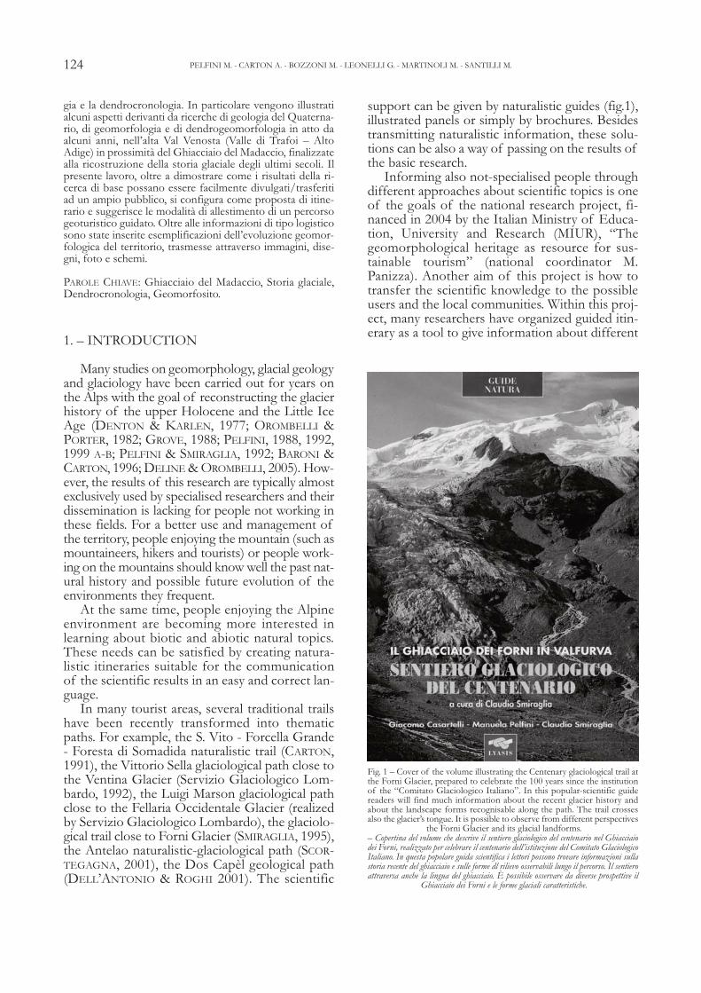
support can be given by naturalistic guides (fig.1),illustrated panels or simply by brochures. Besidestransmitting naturalistic information, these solu-tions can be also a way of passing on the results ofthe basic research.
Informing also not-specialised people throughdifferent approaches about scientific topics is oneof the goals of the national research project, fi-nanced in 2004 by the Italian Ministry of Educa-tion, University and Research (MIUR), “Thegeomorphological heritage as resource for sus-tainable tourism” (national coordinator M.Panizza). Another aim of this project is how totransfer the scientific knowledge to the possibleusers and the local communities. Within this proj-ect, many researchers have organized guided itin-erary as a tool to give information about different
124 PELFINI M. - CARTON A. - BOZZONI M. - LEONELLI G. - MARTINOLI M. - SANTILLI M.
Fig. 1 – Cover of the volume illustrating the Centenary glaciological trail atthe Forni Glacier, prepared to celebrate the 100 years since the institutionof the “Comitato Glaciologico Italiano”. In this popular-scientific guidereaders will find much information about the recent glacier history andabout the landscape forms recognisable along the path. The trail crossesalso the glacier’s tongue. It is possible to observe from different perspectives
the Forni Glacier and its glacial landforms.– Copertina del volume che descrive il sentiero glaciologico del centenario nel Ghiacciaiodei Forni, realizzato per celebrare il centenario dell’istituzione del Comitato GlaciologicoItaliano. In questa popolare guida scientifica i lettori possono trovare informazioni sullastoria recente del ghiacciaio e sulle forme dl rilievo osservabili lungo il percorso. Il sentieroattraversa anche la lingua del ghiacciaio. È possibile osservare da diverse prospettive il
Ghiacciaio dei Forni e le forme glaciali caratteristiche.
scientific results in geomorphology, geology,glaciology, botany, ecology, zoology, etc.
In upper Val Venosta (Trafoi Valley-Alto Adige),close to the Madaccio Glacier, many different re-searches had been performed for years with the goalof reconstructing the glacier history of the last cen-turies through studies in Quaternary geology (BINI etalii, 1996), in geomorphology (MARTINOLI, 2005)and in dendrogeomorphology (PELFINI, 1999 a-b).The goal of this work is to demonstrate how geo-morphological and vegetational aspects both concurin the reconstruction of Holocene glacier history.Moreover, this kind of integration allows to under-stand the sequence of the glacial processes. Finally,these naturalistic aspects can be easily observablealong high-mountain trails. The proposed work is anexample showing how to apply these concepts alonga thematic itinerary where geomorphology and den-drochronology are the two main subjects.
2. – STUDY AREA
The upper Trafoi Valley is located inside theStelvio National Park, in the Alto Adige side ofthe Ortles-Cevedale Group (fig. 2).
This valley is highly attractive for tourists and itis frequented by thousands of people going to the
Passo dello Stelvio, visiting the surroundings andwalking along the numerous tourist paths towardsthe mountain tops and huts.
The idea to propose a naturalistic thematic pathin the upper Trafoi Valley comes also from the recentrequirement to widen the tourist offer during sum-mer months. This is done as an alternative to thesummer ski activities, which in the recent years haveseen a progressive reduction in the available periodbecause of the contraction of the glacial surfaces onwhich ski runs are open (DIOLAIUTI et alii, 2006).
In Trafoi Valley six glaciers are currently pre-sent: Vedretta della Tabaretta, Vedretta Alta del-l’Ortles, Vedretta Bassa dell’Ortles, Vedretta diTrafoi, Vedretta del Madaccio and Vedretta Piana.
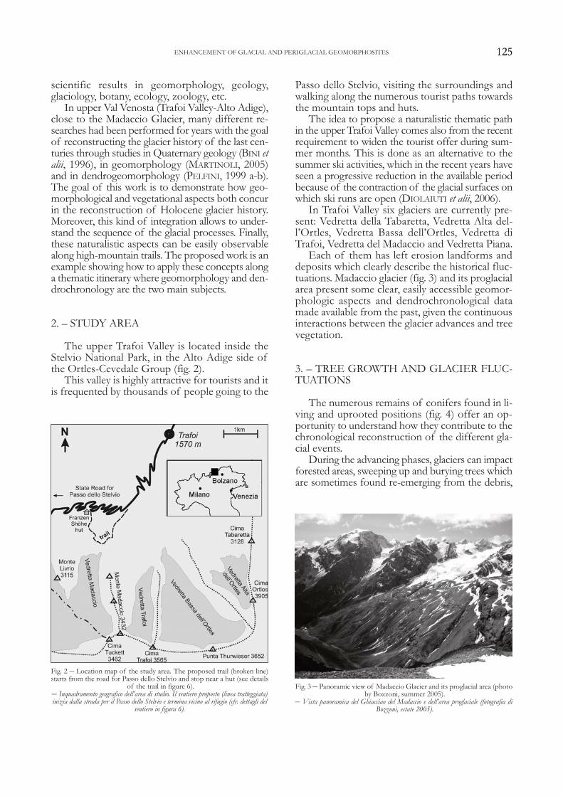
Each of them has left erosion landforms anddeposits which clearly describe the historical fluc-tuations. Madaccio glacier (fig. 3) and its proglacialarea present some clear, easily accessible geomor-phologic aspects and dendrochronological datamade available from the past, given the continuousinteractions between the glacier advances and treevegetation.
3. – TREE GROWTH AND GLACIER FLUC-TUATIONS
The numerous remains of conifers found in li-ving and uprooted positions (fig. 4) offer an op-portunity to understand how they contribute to thechronological reconstruction of the different gla-cial events.
During the advancing phases, glaciers can impactforested areas, sweeping up and burying trees whichare sometimes found re-emerging from the debris,
125ENHANCEMENT OF GLACIAL AND PERIGLACIAL GEOMORPHOSITES
Fig. 2 – Location map of the study area. The proposed trail (broken line)starts from the road for Passo dello Stelvio and stop near a hut (see details
of the trail in figure 6).– Inquadramento geografico dell’area di studio. Il sentiero proposto (linea tratteggiata)inizia dalla strada per il Passo dello Stelvio e termina vicino al rifugio (cfr. dettagli del
sentiero in figura 6).
Fig. 3 – Panoramic view of Madaccio Glacier and its proglacial area (photoby Bozzoni, summer 2005).
– Vista panoramica del Ghiacciao del Madaccio e dell’area proglaciale (fotografia diBozzoni, estate 2005).
125
and sometimes damaging the trees beside the ton-gue or those at the limit of the area, in the frontalposition, reached by the glacier terminus (fig. 5).
Generally, trees at the margins of the advancingtongue, record the same climatic events recordedby the trees growing at a larger distance from theglacier. The situation when the glacial ice reachesthe stem or the roots is quite different. In this casethe tree suffers and forms particularly narrow rings(SCHWEINGRUBER, 1996). In both cases trees allowprecise reconstruction of the glacier history. Infact the date of tree death obtained from stemsstill in situ allows precise determination of the yearin which the glacier reached a certain position. Ifthis position is coincident with a frontal moraine,it is possible to date the moraine deposition phase.Similarly, damage or disturbances found on livingtrees, such as scars and compression wood, allowto date the glacier impact (fig. 5). On the contrary,logs buried in the lateral moraines can only indi-cate the thickness of the glacier tongue at the mo-ment of the insertion into the moraine itself. Infact, their death could have happened also yearsbefore and also can be due to different causes(SCHWEINGRUBER, 1988; PELFINI, 2003; 2006).
4. – GLACIAL AND PERIGLACIAL LAND-FORMS AS GEOMORPHOSITES
The combination of attributes and values ofthe “Madaccio” site in general and in its details,allow the area to be defined as a possible geomor-phosite, as proposed by PANIZZA (2005); PANIZZA& PIACENTE, (2003), PELFINI & SMIRAGLIA (2003),CARTON et alii (2005), PRALONG & REYNARD(2005), REYNARD, (2005).
Concerning the scientific attribute, the area inwhich the Madaccio Glacier is located represents adidactic example, a model of geomorphological evolutionand a paleoenvironmental evidence. The didactic exampleis given by a series of very well preserved erosionand accumulation landforms, typical of a glaciallandscape, allowing observation and understandingof the abrasion processes (roches moutonnées,striae, crescentic gouges, glacial valley “rieghel” etc.),and of deposition ones (accretion moraines, super-position moraines, proglacial fans, etc.). The geomor-phological evolution model comes from the interactionsof the glacial, slope and fluvial forms describing thecomplex vicissitudes alternating over time, duringrepeated glacier advance, stasis and retreat phases.The paleoenvironmental evidence is documented by a se-ries of morainic ridges, mainly dated, allowing thereconstruction of relative or absolute chronology.It is possible to add also the ecological support given by
126 PELFINI M. - CARTON A. - BOZZONI M. - LEONELLI G. - MARTINOLI M. - SANTILLI M.
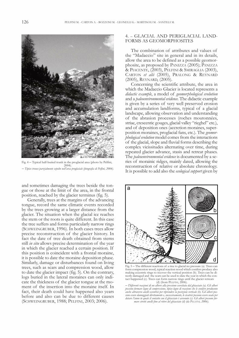
Fig. 4 – Typical half-buried trunk in the proglacial area (photo by Pelfini, 2004).
– Tipico tronco parzialmente sepolto nell’area proglaciale (fotografia di Pelfini, 2004).
Fig. 5 – The different reactions of a tree to glacial ice pressure (a). Trees canform compression wood, typical reaction wood which conifers produce alsomaking eccentric rings to recover the vertical position (b). Trees can be di-rectly damaged and the scars can be used to date the year in which the con-tact happened (c). Trees can form narrow rings until the glacier retreats
(d) (from PELFINI, 2006).– Differenti reazioni di un albero alla pressione esercitata dal ghiacciaio (a). Gli alberipossono formare legno di compressione, tipico legno di reazione che le conifere produconoanche attraverso anelli eccentrici per riprendere la posizione verticale (b). Gli alberi pos-sono essere danneggiati direttamente e, successivamente, le cicatrici possono essere usate perdatare l’anno in quale il contatto con il ghiacciaio è avvenuto (c). Gli alberi possono for-
mare stretti anelli fino al ritiro del ghiacciaio (d) (da PELFINI, 2006).
the dendrochronological documentation to these at-tributes. The presence of easily visible buried trunksand the numerous trees damaged and deformed bythe geomorphological processes and by atmos-pheric events, provide added value to the geomor-phosite, not only concerning the dating of glacialdeposits, but also with regard to the paleoenviron-mental reconstruction of the site.
The morphological and vegetational elementscan be observed either walking along a trail withinthe proglacial area (fig. 2) or along a panoramic one(trail no. 20, connecting the Garibaldi hut, nearPasso dello Stelvio and the end of the “Forcola”chair lift) on the opposite side of the valley.
The possibility of exploring the same subjectfirstly in detail and then in its entirety, also plays aneducational role because it shows to the tourists thescientific approach, resolving a naturalistic problemstarting from the analysis of the single aspects whichare later jointly interpreted, leading to a synthetic vi-sion. The reading of past history using the data sup-plied by the glaciological and dendrochronologicalstudies, gives also to the tourists an example of an in-tegrated approach for reading the landscape, equallyinvolving both biological and geological disciplines.
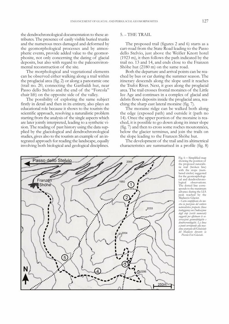
5. – THE TRAIL
The proposed trail (figures 2 and 6) starts as acart-road from the State Road leading to the Passodello Stelvio, just above the Weißer Knott hotel(1923 m), it then follows the path indicated by thetrail no. 13 and 14, and ends close to the FranzenShöhe hut (2180 m) on the same road.
Both the departure and arrival points can be rea-ched by bus or car during the summer season. Theitinerary descends along the slope until it reachesthe Trafoi River. Next, it goes along the proglacialarea. The trail crosses frontal moraines of the LittleIce Age and continues in a complex of glacial anddebris flows deposits inside the proglacial area, rea-ching the sharp east lateral moraine (fig. 7).
The moraine ridge can be walked both alongthe edge (exposed path) and outside it (path no14). Once the upper portion of the moraine is rea-ched, it is possible to go down along its inner slope(fig. 7) and then to cross some roches moutonnées,below the glacier terminus, and join the trails onthe slope leading to the Franzen Shöhe hut.
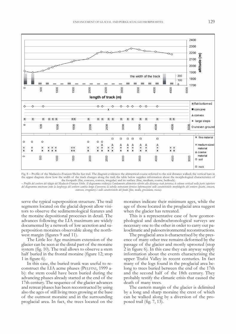
The development of the trail and its altimetricalcharacteristics are summarised in a profile (fig. 8)
127ENHANCEMENT OF GLACIAL AND PERIGLACIAL GEOMORPHOSITES
Fig. 6 – Simplified mapshowing the position ofthe proposed naturalis-tic trail (broken line)with the stops (num-bered circles) suggestedfor the geomorphologi-cal and dendrochrono-logical observations.The dotted line corre-sponds to the maximumadvance during the LIApeak reached by theMadaccio Glacier.– Carta semplificata che mo-stra la posizione del sentieronaturalistico proposto (lineatratteggiata) con l’indicazionedegli stop (cerchi numerati)suggeriti per effettuare le os-servazioni geomorfologiche edendrocronologiche. La lineaa punti corrisponde alla mas-sima avanzata del Ghaicciaiodel Madaccio durante la
Piccola-Età Glaciale.

equipped with useful information for the hiker (e.g.,width and morphology of the footpath, type ofsubstrate etc.) (BOZZONI & PELFINI, 2007).
The itinerary we would like to create will bestructured into stops allowing detailed observa-tions, and sometimes panoramic views, of the lan-dforms that characterises a proglacial area.Depending on the illustrative support, the itinerarywill be provided with panels, guides, geotouristicmap, etc.; the single situations will be described indetail with the aid of drawings and commentedphotos, referring, when necessary, to basic con-cepts useful to explain the phenomena.
6. – LANDFORMS AND TYPICAL SITUA-TIONS ALONG THE TRAIL
Using the results of scientific researches, someparticularly meaningful points along the itinerarywill be shown as an example of how we want to il-lustrate the entire path.
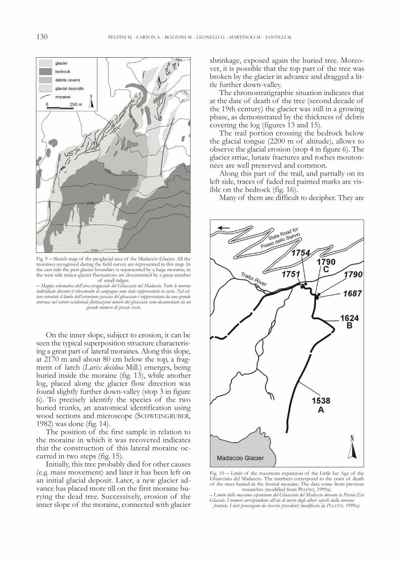
The Madaccio is the largest glacier of the TrafoiValley and occupies a wide and irregular valley ex-tending, north-south for 4.5 Km, between thethree rocky peaks of the Madaccio mountain, onthe east side, and the wide glacialized ridge thatreaches the Passo dello Stelvio (2758 m) fromPunta degli Spiriti (3465 m). This glacier is a typi-cal alpine type, constituted by a wide accumulationarea which originates one tongue reaching 2650 m.Its moraines deposed during the Little Ice Age andfollowing advance and retreat phases are well rep-resented almost everywhere (fig. 9).
The outmost frontal moraines, located at 1930m, document the maximum Holocene advancecorresponding to the LIA peak, which can bedated to 1821 (PELFINI, 1999 a-b) for the Madac-cio Glacier (fig. 10) preceded by an advancingphase at the end of the 18th century.
The limits reached by the glacier tongue duringthe LIA are documented by portions of well pre-served moraines, some of which are very sharp.On their inner slopes it is locally possible to ob-
128 PELFINI M. - CARTON A. - BOZZONI M. - LEONELLI G. - MARTINOLI M. - SANTILLI M.
Fig. 7 – The eastern lateral moraine of the Ghiacciaio del Madaccio. The pseudostratification given from the process of superposition is visible. The arrows in-dicate the small trail that crosses down the inner moraine slope (photo by Bozzoni, 2005).
– Morena laterale orientale del Ghiacciaio del Madaccio. È visibile la pseudo stratificazione dovuta ai processi di sovrapposizione. Le frecce indicano lo stretto sentiero che attraversa il ver-sante interno della morena (fotografia di Bozzoni, 2005).
129
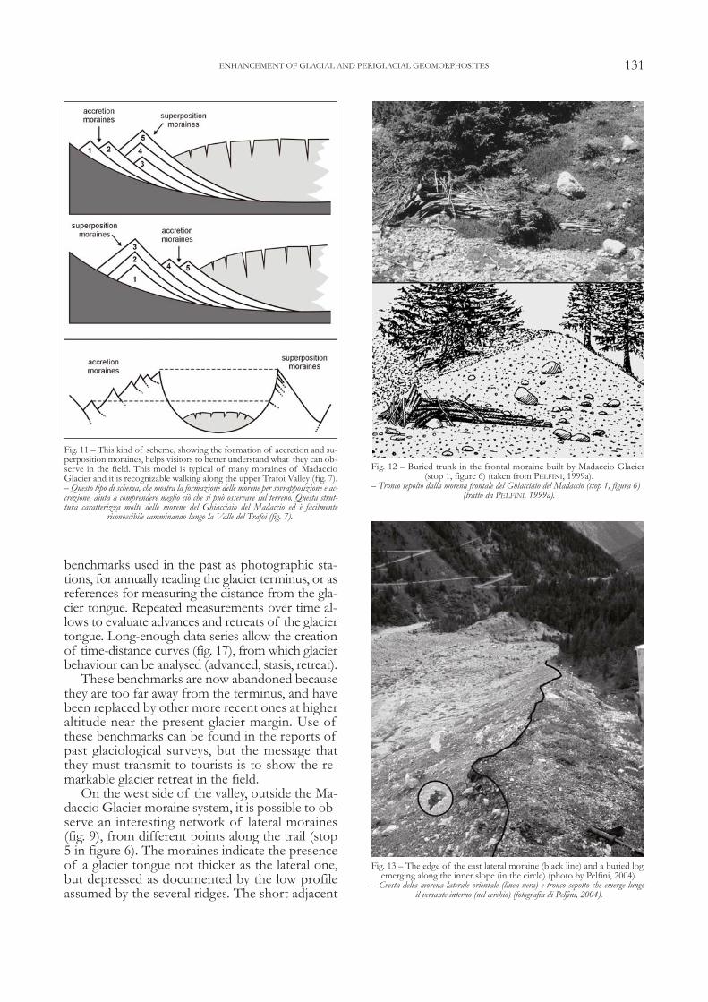
serve the typical superposition structure. The trailsegments located on the glacial deposit allow visi-tors to observe the sedimentological features andthe moraine depositional processes in detail. Theadvances following the LIA maximum are widelydocumented by a network of low accretion and su-perposition moraines observable along the north-west margin (figures 9 and 11).
The Little Ice Age maximum extension of theglacier can be seen at the distal part of the morainesystem (fig. 10). The trail allows to observe a stemhalf buried in the frontal moraine (figure 12; stop1 in figure 6).
In this case, the buried trunk was useful to re-construct the LIA acme phases (PELFINI, 1999 a-b): the stem could have been buried during theadvancing phases already started at the end of the17th century. The sequence of the glacier advancesand retreat phases has been reconstructed by usingalso the ages of still living trees growing at the baseof the outmost moraine and in the surroundingproglacial area. In fact, the trees located on the
moraines indicate their minimum ages, while theage of those located in the proglacial area suggestwhen the glacier has retreated.
This is a representative case of how geomor-phological and dendrochronological surveys arenecessary one to the other in order to carry out pa-leoclimatic and paleoenvironmental reconstructions.
The proglacial area is characterised by the pres-ence of many other tree remains deformed by thepassage of the glacier and mostly uprooted (stop2 in figure 6). In this case they can anyway supplyinformation about the events characterising theupper Trafoi Valley in recent centuries. In factmany of the logs found in the proglacial area be-long to trees buried between the end of the 17thand the second half of the 18th century. Theyprobably testify the climatic crisis that caused thedeath of many trees.
The eastern margin of the glacier is delimitedby a long and sharp moraine the crest of whichcan be walked along by a diversion of the pro-posed trail (fig. 7, 13).
ENHANCEMENT OF GLACIAL AND PERIGLACIAL GEOMORPHOSITES
Fig. 8 – Profile of the Madaccio-Franzen Shöhe hut trail. The diagram evidences the altimetrical course referred to the real distance walked; the vertical bars inthe upper diagram show how the width of the track changes along the trail; the table below supplies information about the morphological characteristics of
the footpath (flat, concave, convex, irregular) and its surface (fine, medium, coarse, bedrock).– Profilo del sentiero del rifugio del Madaccio-Franzen Shöhe. Il diagramma evidenzia l’andamento altimetrico riferito alla distanza reale percorsa; le colonne verticali nella parte superioredel diagramma mostrano come la larghezza del sentiero cambia lungo il percorso; la tabella sottostante fornisce informazioni sulle caratteristiche morfologiche del sentiero (piatto, concavo,
convesso, irregolare) e sulle caratteristiche del fondo (fine, medio, grossolano, roccia).
On the inner slope, subject to erosion, it can beseen the typical superposition structure characteris-ing a great part of lateral moraines. Along this slope,at 2170 m and about 80 cm below the top, a frag-ment of larch (Larix decidua Mill.) emerges, beingburied inside the moraine (fig. 13), while anotherlog, placed along the glacier flow direction wasfound slightly further down-valley (stop 3 in figure6). To precisely identify the species of the twoburied trunks, an anatomical identification usingwood sections and microscope (SCHWEINGRUBER,1982) was done (fig. 14).
The position of the first sample in relation tothe moraine in which it was recovered indicatesthat the construction of this lateral moraine oc-curred in two steps (fig. 15).
Initially, this tree probably died for other causes(e.g. mass movement) and later it has been left onan initial glacial deposit. Later, a new glacier ad-vance has placed more till on the first moraine bu-rying the dead tree. Successively, erosion of theinner slope of the moraine, connected with glacier
shrinkage, exposed again the buried tree. Moreo-ver, it is possible that the top part of the tree wasbroken by the glacier in advance and dragged a lit-tle further down-valley.
The chronostratigraphic situation indicates thatat the date of death of the tree (second decade ofthe 19th century) the glacier was still in a growingphase, as demonstrated by the thickness of debriscovering the log (figures 13 and 15).
The trail portion crossing the bedrock belowthe glacial tongue (2200 m of altitude), allows toobserve the glacial erosion (stop 4 in figure 6). Theglacier striae, lunate fractures and roches mouton-nées are well preserved and common.
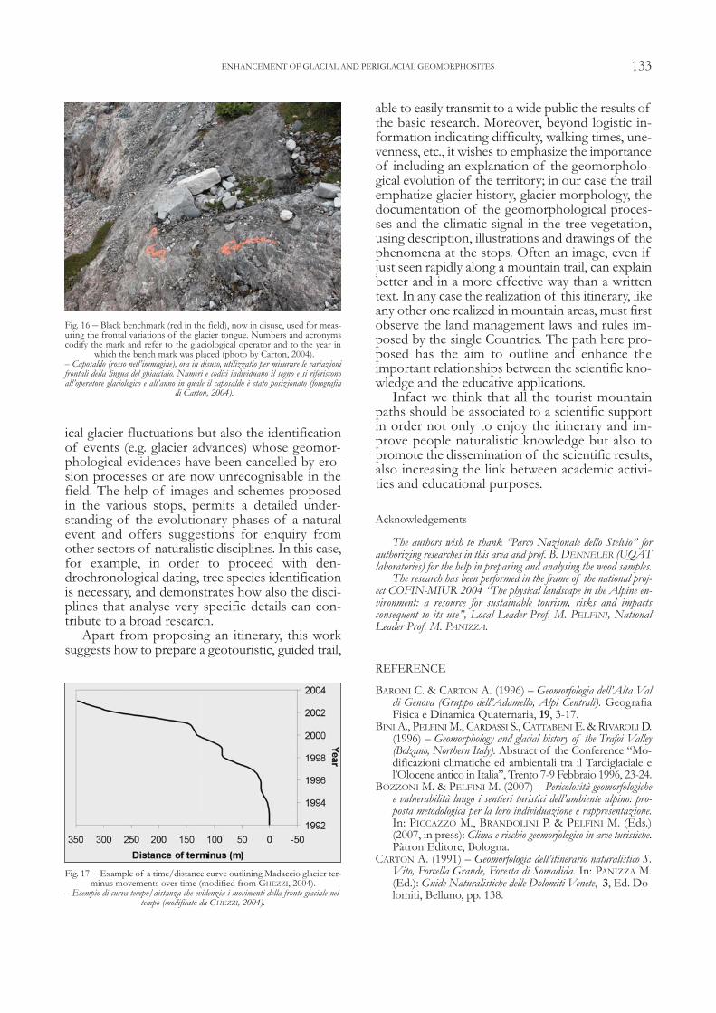
Along this part of the trail, and partially on itsleft side, traces of faded red painted marks are vis-ible on the bedrock (fig. 16).
Many of them are difficult to decipher. They are
130 PELFINI M. - CARTON A. - BOZZONI M. - LEONELLI G. - MARTINOLI M. - SANTILLI M.
Fig. 9 – Sketch map of the proglacial area of the Madaccio Glacier. All themoraines recognised during the field survey are represented in this map. Inthe east side the past glacier boundary is represented by a huge moraine; inthe west side minor glacier fluctuations are documented by a great number
of small ridges.– Mappa schematica dell’area proglaciale del Ghiacciaio del Madaccio. Tutte le moreneindividuate durante il rilevamento di campagna sono state rappresentate in carta. Nel set-tore orientale il limite dell’estensione passata del ghiacciaio è rappresentata da una grandemorena; nel settore occidentale fluttuazioni minori del ghiacciaio sono documentate da un
grande numero di piccole creste.
Fig. 10 – Limit of the maximum expansion of the Little Ice Age of theGhiacciaio del Madaccio. The numbers correspond to the years of deathof the trees buried in the frontal moraine. The data come from previous
researches (modified from PELFINI, 1999a).– Limite della massima espansione del Ghiacciaio del Madaccio durante la Piccola EtàGlaciale. I numeri corrispondono all’età di morte degli alberi sepolti dalla morena
frontale. I dati provengono da ricerche precedenti (modificato da PELFINI, 1999a).
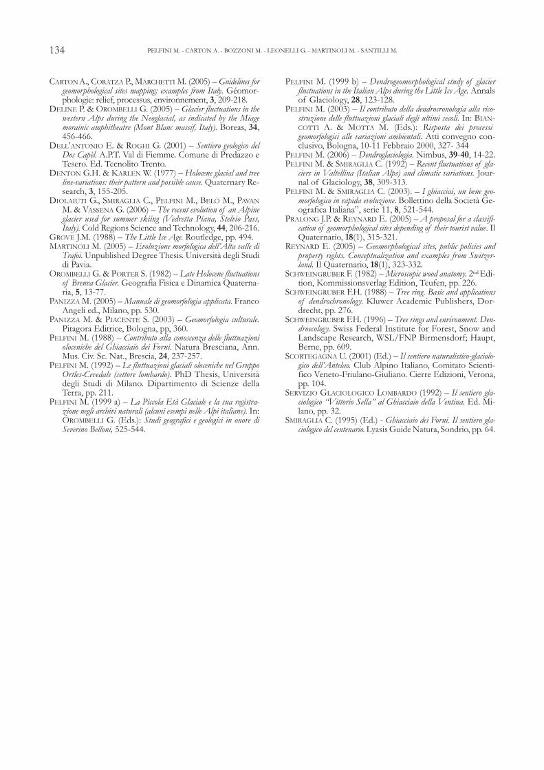
benchmarks used in the past as photographic sta-tions, for annually reading the glacier terminus, or asreferences for measuring the distance from the gla-cier tongue. Repeated measurements over time al-lows to evaluate advances and retreats of the glaciertongue. Long-enough data series allow the creationof time-distance curves (fig. 17), from which glacierbehaviour can be analysed (advanced, stasis, retreat).
These benchmarks are now abandoned becausethey are too far away from the terminus, and havebeen replaced by other more recent ones at higheraltitude near the present glacier margin. Use ofthese benchmarks can be found in the reports ofpast glaciological surveys, but the message thatthey must transmit to tourists is to show the re-markable glacier retreat in the field.
On the west side of the valley, outside the Ma-daccio Glacier moraine system, it is possible to ob-serve an interesting network of lateral moraines(fig. 9), from different points along the trail (stop5 in figure 6). The moraines indicate the presenceof a glacier tongue not thicker as the lateral one,but depressed as documented by the low profileassumed by the several ridges. The short adjacent
131ENHANCEMENT OF GLACIAL AND PERIGLACIAL GEOMORPHOSITES
Fig. 11 – This kind of scheme, showing the formation of accretion and su-perposition moraines, helps visitors to better understand what they can ob-serve in the field. This model is typical of many moraines of MadaccioGlacier and it is recognizable walking along the upper Trafoi Valley (fig. 7).– Questo tipo di schema, che mostra la formazione delle morene per sovrapposizione e ac-crezione, aiuta a comprendere meglio ciò che si può osservare sul terreno. Questa strut-tura caratterizza molte delle morene del Ghiacciaio del Madaccio ed è facilmente
riconoscibile camminando lungo la Valle del Trafoi (fig. 7).
Fig. 12 – Buried trunk in the frontal moraine built by Madaccio Glacier(stop 1, figure 6) (taken from PELFINI, 1999a).
– Tronco sepolto dalla morena frontale del Ghiacciaio del Madaccio (stop 1, figura 6)(tratto da PELFINI, 1999a).
Fig. 13 – The edge of the east lateral moraine (black line) and a buried logemerging along the inner slope (in the circle) (photo by Pelfini, 2004).
– Cresta della morena laterale orientale (linea nera) e tronco sepolto che emerge lungoil versante interno (nel cerchio) (fotografia di Pelfini, 2004).

and locally overlapped moraines were deposited inrelation to short-term climatic changes. They te-stify that the glacier margin remained in this posi-tion for rather a long time or that the front reachedit after an advance followed by a phase of retreat.It is interesting to note that the moraine edges aresometimes close side by side, and that in other si-tuations they emerge from the sides of larger ridges.
Focussing on the edges of single moraines, wecan imagine the different shapes and extensionsthe glacier margin assumed here sometimes. At acertain moment in this complex succession ofevents, the glacier also tried to generate a small lat-eral tongue. This is documented by the two lobeshaped moraines departing from the previousmoraine system and heading towards the small flu-vioglacial plain.
7. – CONCLUSION
From the illustrated examples, we conclude thatclassic geomorphological research supplies thebasis for understanding phenomena and processesleaving extremely detailed documentation in thefield, but usually it can be recognized only by theexpert eye. However it is possible to offer a correctand scientific knowledge through simplificationseasily realizable using photos, schemes, drawingsetc also to people without a naturalistic culture. Inthis way, an itinerary, where the beauty of the land-scape dominates, supplies also the possibility togive a good scientific formation.
In the specific case here presented, the supportof other disciplines such as dendrochronology, al-lows not only a detailed reconstruction of histor-
132 PELFINI M. - CARTON A. - BOZZONI M. - LEONELLI G. - MARTINOLI M. - SANTILLI M.
Fig. 14 – Thin section (15 μm thick, 200x) prepared for species identifica-tion. Both samples are Larix decidua Mill. (a) radial section, (b) transversal
section (photo by Leonelli, 2005).– Sezioni sottili (15 μm di spessore, 200x) preparata per l’identificazione delle specie.Entrambi i campioni sono Larix decidua Mill. (a) sezione radiale, (b) sezione trasver-
sale (fotografia di Leonelli, 2005).
Fig. 15 – The scheme represents the hypothetical “history” of the buriedtree. The tree is still living (a). The tree dies from unknown causes, but notones due to direct glacier action, and lies down on the forming moraine (b).The glacier is still growing and continues to deposit till on the previousmoraine covering the trunk (c). When the glacier retreats, the top of the trunk
emerges due to erosion processes active on the inner moraine slope (d).-– Lo schema rappresenta l’ipotetica “storia” del tronco sepolto. L’albero è ancora vivo(a). L’albero muore per cause ignote, comunque non legate all’azione diretta del ghiacciaioe cade sulla morena che si sta formando (b). Il ghiacciaio continua a crescere e ad accu-mulare materiale sulla morena ricoprendo il tronco (c). Quando il ghiacciaio arretra laparte superiore del tronco affiora a causa dei processi erosivi attivi sul versante interno della
morena (d).
133
ical glacier fluctuations but also the identificationof events (e.g. glacier advances) whose geomor-phological evidences have been cancelled by ero-sion processes or are now unrecognisable in thefield. The help of images and schemes proposedin the various stops, permits a detailed under-standing of the evolutionary phases of a naturalevent and offers suggestions for enquiry fromother sectors of naturalistic disciplines. In this case,for example, in order to proceed with den-drochronological dating, tree species identificationis necessary, and demonstrates how also the disci-plines that analyse very specific details can con-tribute to a broad research.
Apart from proposing an itinerary, this worksuggests how to prepare a geotouristic, guided trail,
able to easily transmit to a wide public the results ofthe basic research. Moreover, beyond logistic in-formation indicating difficulty, walking times, une-venness, etc., it wishes to emphasize the importanceof including an explanation of the geomorpholo-gical evolution of the territory; in our case the trailemphatize glacier history, glacier morphology, thedocumentation of the geomorphological proces-ses and the climatic signal in the tree vegetation,using description, illustrations and drawings of thephenomena at the stops. Often an image, even ifjust seen rapidly along a mountain trail, can explainbetter and in a more effective way than a writtentext. In any case the realization of this itinerary, likeany other one realized in mountain areas, must firstobserve the land management laws and rules im-posed by the single Countries. The path here pro-posed has the aim to outline and enhance theimportant relationships between the scientific kno-wledge and the educative applications.
Infact we think that all the tourist mountainpaths should be associated to a scientific supportin order not only to enjoy the itinerary and im-prove people naturalistic knowledge but also topromote the dissemination of the scientific results,also increasing the link between academic activi-ties and educational purposes.
Acknowledgements
The authors wish to thank “Parco Nazionale dello Stelvio” forauthorizing researches in this area and prof. B. DENNELER (UQATlaboratories) for the help in preparing and analysing the wood samples.
The research has been performed in the frame of the national proj-ect COFIN-MIUR 2004 “The physical landscape in the Alpine en-vironment: a resource for sustainable tourism, risks and impactsconsequent to its use”, Local Leader Prof. M. PELFINI, NationalLeader Prof. M. PANIZZA.
REFERENCE
BARONI C. & CARTON A. (1996) – Geomorfologia dell’Alta Valdi Genova (Gruppo dell’Adamello, Alpi Centrali). GeografiaFisica e Dinamica Quaternaria, 19, 3-17.
BINI A., PELFINI M., CARDASSI S., CATTABENI E. & RIVAROLI D.(1996) – Geomorphology and glacial history of the Trafoi Valley(Bolzano, Northern Italy). Abstract of the Conference “Mo-dificazioni climatiche ed ambientali tra il Tardiglaciale el’Olocene antico in Italia”, Trento 7-9 Febbraio 1996, 23-24.
BOZZONI M. & PELFINI M. (2007) – Pericolosità geomorfologichee vulnerabilità lungo i sentieri turistici dell’ambiente alpino: pro-posta metodologica per la loro individuazione e rappresentazione.In: PICCAZZO M., BRANDOLINI P. & PELFINI M. (Eds.)(2007, in press): Clima e rischio geomorfologico in aree turistiche.Pàtron Editore, Bologna.
CARTON A. (1991) – Geomorfologia dell’itinerario naturalistico S.Vito, Forcella Grande, Foresta di Somadida. In: PANIZZA M.(Ed.): Guide Naturalistiche delle Dolomiti Venete, 3, Ed. Do-lomiti, Belluno, pp. 138.
ENHANCEMENT OF GLACIAL AND PERIGLACIAL GEOMORPHOSITES
Fig. 16 – Black benchmark (red in the field), now in disuse, used for meas-uring the frontal variations of the glacier tongue. Numbers and acronymscodify the mark and refer to the glaciological operator and to the year in
which the bench mark was placed (photo by Carton, 2004).– Caposaldo (rosso nell’immagine), ora in disuso, utilizzatio per misurare le variazionifrontali della lingua del ghiacciaio. Numeri e codici individuano il segno e si riferisconoall’operatore glaciologico e all’anno in quale il caposaldo è stato posizionato (fotografia
di Carton, 2004).
Fig. 17 – Example of a time/distance curve outlining Madaccio glacier ter-minus movements over time (modified from GHEZZI, 2004).
– Esempio di curva tempo/distanza che evidenzia i movimenti della fronte glaciale nel tempo (modificato da GHEZZI, 2004).
134
CARTON A., CORATZA P., MARCHETTI M. (2005) – Guidelines forgeomorphological sites mapping: examples from Italy. Géomor-phologie: relief, processus, environnement, 3, 209-218.
DELINE P. & OROMBELLI G. (2005) – Glacier fluctuations in thewestern Alps during the Neoglacial, as indicated by the Miagemorainic amphitheatre (Mont Blanc massif, Italy). Boreas, 34,456-466.
DELL’ANTONIO E. & ROGHI G. (2001) – Sentiero geologico delDos Capèl. A.P.T. Val di Fiemme. Comune di Predazzo eTesero. Ed. Tecnolito Trento.
DENTON G.H. & KARLEN W. (1977) – Holocene glacial and treeline-variations: their pattern and possible cause. Quaternary Re-search, 3, 155-205.
DIOLAIUTI G., SMIRAGLIA C., PELFINI M., BELÒ M., PAVANM. & VASSENA G. (2006) – The recent evolution of an Alpineglacier used for summer skiing (Vedretta Piana, Stelvio Pass,Italy). Cold Regions Science and Technology, 44, 206-216.
GROVE J.M. (1988) – The Little Ice Age. Routledge, pp. 494.MARTINOLI M. (2005) – Evoluzione morfologica dell’Alta valle di
Trafoi. Unpublished Degree Thesis. Università degli Studidi Pavia.
OROMBELLI G. & PORTER S. (1982) – Late Holocene fluctuationsof Brenva Glacier. Geografia Fisica e Dinamica Quaterna-ria, 5, 13-77.
PANIZZA M. (2005) – Manuale di geomorfologia applicata. FrancoAngeli ed., Milano, pp. 530.
PANIZZA M. & PIACENTE S. (2003) – Geomorfologia culturale.Pitagora Editrice, Bologna, pp, 360.
PELFINI M. (1988) – Contributo alla conoscenza delle fluttuazionioloceniche del Ghiacciaio dei Forni. Natura Bresciana, Ann.Mus. Civ. Sc. Nat., Brescia, 24, 237-257.
PELFINI M. (1992) – Le fluttuazioni glaciali oloceniche nel GruppoOrtles-Cevedale (settore lombardo). PhD Thesis, Universitàdegli Studi di Milano. Dipartimento di Scienze dellaTerra, pp. 211.
PELFINI M. (1999 a) – La Piccola Età Glaciale e la sua registra-zione negli archivi naturali (alcuni esempi nelle Alpi italiane). In:OROMBELLI G. (Eds.): Studi geografici e geologici in onore diSeverino Belloni, 525-544.
PELFINI M. (1999 b) – Dendrogeomorphological study of glacierfluctuations in the Italian Alps during the Little Ice Age. Annalsof Glaciology, 28, 123-128.
PELFINI M. (2003) – Il contributo della dendrocronologia alla rico-struzione delle fluttuazioni glaciali degli ultimi secoli. In: BIAN-COTTI A. & MOTTA M. (Eds.): Risposta dei processigeomorfologici alle variazioni ambientali. Atti convegno con-clusivo, Bologna, 10-11 Febbraio 2000, 327- 344
PELFINI M. (2006) – Dendroglaciologia. Nimbus, 39-40, 14-22.PELFINI M. & SMIRAGLIA C. (1992) – Recent fluctuations of gla-
ciers in Valtellina (Italian Alps) and climatic variations. Jour-nal of Glaciology, 38, 309-313.
PELFINI M. & SMIRAGLIA C. (2003). – I ghiacciai, un bene geo-morfologico in rapida evoluzione. Bollettino della Società Ge-ografica Italiana”, serie 11, 8, 521-544.
PRALONG J.P. & REYNARD E. (2005) – A proposal for a classifi-cation of geomorphological sites depending of their tourist value. IlQuaternario, 18(1), 315-321.
REYNARD E. (2005) – Geomorphological sites, public policies andproperty rights. Conceptualization and examples from Switzer-land. Il Quaternario, 18(1), 323-332.
SCHWEINGRUBER F. (1982) – Microscopic wood anatomy. 2nd Edi-tion, Kommissionsverlag Edition, Teufen, pp. 226.
SCHWEINGRUBER F.H. (1988) – Tree ring. Basic and applicationsof dendrochronology. Kluwer Academic Publishers, Dor-drecht, pp. 276.
SCHWEINGRUBER F.H. (1996) – Tree rings and environment. Den-droecology. Swiss Federal Institute for Forest, Snow andLandscape Research, WSL/FNP Birmensdorf; Haupt,Berne, pp. 609.
SCORTEGAGNA U. (2001) (Ed.) – Il sentiero naturalistico-glaciolo-gico dell’Antelao. Club Alpino Italiano, Comitato Scienti-fico Veneto-Friulano-Giuliano. Cierre Edizioni, Verona,pp. 104.
SERVIZIO GLACIOLOGICO LOMBARDO (1992) – Il sentiero gla-ciologico “Vittorio Sella” al Ghiacciaio della Ventina. Ed. Mi-lano, pp. 32.
SMIRAGLIA C. (1995) (Ed.) - Ghiacciaio dei Forni. Il sentiero gla-ciologico del centenario. Lyasis Guide Natura, Sondrio, pp. 64.
PELFINI M. - CARTON A. - BOZZONI M. - LEONELLI G. - MARTINOLI M. - SANTILLI M.