The Edwards Aquifer - The Maxwell School of Syracuse ... · THE EDWARDS AQUIFER (PART A) Amidst of...
49
SYRACUSE UNIVERSITY Maxwell School E-PARCC COLLABORATIVE GOVERNANCE INITIATIVE Program for the Advancement of Research on Conflict and Collaboration THE EDWARDS AQUIFER (PART A) Amidst of one of the worst Texas droughts in recent memory, attorney Robert Gulley wondered why he had left his position at an established law practice to take on the position of program director for the Edwards Aquifer Recovery Implementation Program (EARIP). As the program director, Robert now worked for 26 different organizations and his job was to assist them, using a consensus-based stakeholder process, through one of the most contentious and intractable national disputes involving scarce groundwater resources at the Edwards Aquifer, one of the most valuable water resources in the Central Texas area. This dispute had already spanned decades and, to make this task even more daunting, the competing interests on both sides had made numerous unsuccessful attempts over the years to resolve this conflict. Hot weather, droughts, and the resulting conflicts between stakeholders are frequent occurrences in Texas. Robert, who had returned to his home state specifically for this position, knew that this drought would only intensify the tensions amongst the stakeholders involved. The Edwards Aquifer (“Aquifer”) provides approximately 90 percent of the water for over two million people living and working in the South-Central Texas area. The Aquifer supplies the water that services the city of San Antonio and other municipalities; a multi-million agricultural and ranching industry in the western part of the region that views water as a coveted property right; as well as the recreational activities that provide the backbone of the economies of rapidly-growing, nearby cities of San Marcos and New Braunfels (Figure 1). Through springs located in both San Marcos and New Braunfels, the Aquifer also contributes directly to the survival of eight species protected by the federal Endangered Species Act (ESA) and feeds water This case was written by Adam Zerrenner of the U.S. Fish and Wildlife Services and Robert Gulley of the Texas Comptroller of Public Accounts and was awarded Honorable Mention in E-PARCC’s 2015-2016 Competition for Collaborative Public Management, Governance, and Problem-Solving Teaching Materials. A special thanks to John Sabala for reviewing and editing the case. The findings and conclusions in this case and teaching note are those of the authors and do not necessarily represent the views of the U.S. Fish and Wildlife Service or Texas Comptroller of Public Accounts. The case is intended for classroom discussion and not to suggest either effective or ineffective responses to the situation depicted. It may be copied as many times as needed, provided that the authors and E- PARCC are given full credit. E-PARCC is a project of the Collaborative Governance Initiative, Program for the Advancement of Research on Conflict and Collaboration- a research, teaching and practice center within Syracuse University’s School of Citizenship and Public Affair. https://www.maxwell.syr.edu/parcc_eparcc.aspx 1
Transcript of The Edwards Aquifer - The Maxwell School of Syracuse ... · THE EDWARDS AQUIFER (PART A) Amidst of...

SYRACUSE UNIVERSITY Maxwell School
E-PARCC COLLABORATIVE GOVERNANCE INITIATIVE
Program for the Advancement of Research on Conflict and Collaboration
THE EDWARDS AQUIFER
(PART A)
Amidst of one of the worst Texas droughts in recent memory attorney Robert Gulley wondered
why he had left his position at an established law practice to take on the position of program
director for the Edwards Aquifer Recovery Implementation Program (EARIP) As the program
director Robert now worked for 26 different organizations and his job was to assist them using
a consensus-based stakeholder process through one of the most contentious and intractable
national disputes involving scarce groundwater resources at the Edwards Aquifer one of the
most valuable water resources in the Central Texas area This dispute had already spanned
decades and to make this task even more daunting the competing interests on both sides had
made numerous unsuccessful attempts over the years to resolve this conflict Hot weather
droughts and the resulting conflicts between stakeholders are frequent occurrences in Texas
Robert who had returned to his home state specifically for this position knew that this drought
would only intensify the tensions amongst the stakeholders involved
The Edwards Aquifer (ldquoAquiferrdquo) provides approximately 90 percent of the water for over two
million people living and working in the South-Central Texas area The Aquifer supplies the
water that services the city of San Antonio and other municipalities a multi-million agricultural
and ranching industry in the western part of the region that views water as a coveted property
right as well as the recreational activities that provide the backbone of the economies of
rapidly-growing nearby cities of San Marcos and New Braunfels (Figure 1) Through springs
located in both San Marcos and New Braunfels the Aquifer also contributes directly to the
survival of eight species protected by the federal Endangered Species Act (ESA) and feeds water
This case was written by Adam Zerrenner of the US Fish and Wildlife Services and Robert Gulley of the Texas
Comptroller of Public Accounts and was awarded Honorable Mention in E-PARCCrsquos 2015-2016 Competition for
Collaborative Public Management Governance and Problem-Solving Teaching Materials A special thanks to John
Sabala for reviewing and editing the case The findings and conclusions in this case and teaching note are those of
the authors and do not necessarily represent the views of the US Fish and Wildlife Service or Texas Comptroller of
Public Accounts The case is intended for classroom discussion and not to suggest either effective or ineffective
responses to the situation depicted It may be copied as many times as needed provided that the authors and E-
PARCC are given full credit E-PARCC is a project of the Collaborative Governance Initiative Program for the
Advancement of Research on Conflict and Collaboration- a research teaching and practice center within Syracuse
Universityrsquos School of Citizenship and Public Affair httpswwwmaxwellsyreduparcc_eparccaspx
1
to the local Guadalupe River and numerous Gulf Coast bays and estuaries Agricultural and
chemical industries located along the Guadalupe River basin depend on the Guadalupe River
much of which originates from the Edwards Aquifer springs during periods of extreme drought
As Robert reviewed the history of the dispute over the use of the Aquifer he began to
comprehend the magnitude of the task facing him and the EARIP stakeholders Robert knew
that water scarcity was a top global risk but was a regional issue as what the South-Central
Texas region was facing and the problem had to be address regionally1 These stakeholders
had a long history of conflict among one another and Robert grew increasingly worried that he
would not be able to help them to work together and manage this scarce water resource
Background
During the mid-1950s Texas experienced a record-setting drought known today as the
ldquoDrought of Recordrdquo The drought hit the south and-central Texas regions particularly hard
Both areas depend heavily on the prolific artesian Edwards Aquifer for its water23 The
Aquiferrsquos water flow fell dramatically at Comal Springs and San Marcos Springs the two largest
springs in Texas and the southwestern United States Comal Springs even stopped flowing for
over four months threatening the surface water supplies on the Guadalupe River and
extirpating one of the two populations of fountain darters (a small fish found in Comal and San
Marcos Springs that was later protected by the ESA) To many observers it became clear that
the region would have to begin managing groundwater to avoid ldquominingrdquo the Aquifer as the
region grew ie pumping more water from the Aquifer annually than is replaced each year by
rainfall4 Many also believed that the most logical solution was for San Antonio the largest and
fastest-growing city in the region and the single greatest user of the Aquifer to develop
alternate surface water supplies to accommodate new growth
Restricting pumping from the Aquifer was not a politically-viable alternative in San Antonio or
elsewhere in the state At that time ldquothe rule of capturerdquo almost exclusively governed
groundwater use in Texas Under this rule a landowner is free to capture and use as much
water as could be beneficially used without waste Moreover the rule of capture aligns with
the heavy emphasis that Texas places on private property rights and in so doing was viewed as
1 See Water crisis ranked as top global risk for the next 10 years World Economic Forum ldquoThe Global Risks Report 2016 11th Editionrdquo 2016 at 13 2 See Appendix 1 Overview of Edwards Aquifer 3 See Appendix 2 Historical Timeline of the Edwards Aquifer Conflict 4 See Appendix 3 History of Water Management in Texas
2
Zavala
Edwards Aquifer Zones
- Contributing Zone
Recharge Zone
- Artesian Zone
bull Comal amp San Marcos Springs
bull J-17 Bexar Index Well
J-27 Uvalde Index Well
McMullen
granting landowners a vested ownership interest in the use of water5
Figure 1 Map of the Edwards Aquifer region showing the contributing zone recharge zone
and artesian zone as well as J-27 and J-17 wells and Comal Springs and San Marcos Springs
As shown in Table A San Antonio initially considered developing alternative water supplies to
decrease its dependence on the Aquifer These attempts were all unsuccessful In many
instances the political will to invest in the future did not exist given the lack of an immediate
public demand and the readily available supply of inexpensive water from the Aquifer
Table A Alternate water supply projects considered but rejected by the City of San Antonio
Water Project Year Potential Yield
Canyon Reservoir 1952-1965 100000 acre-feet
Cuero I and II 1963 221000 acre-feet
Cibolo Reservoir 1974 30000 acre-feet
Lease of Canyon Lake Water 1976 Up to 50000 acre-feet
Applewhite Reservoir 1991 and 1994 50000 acre-feet
5 Illustrative of this point the Texas Legislature created the Edwards Underground Water District (EUWD) in 1959 ldquoto conserve preserve protect and increase the recharge of and prevent pollution of the underground waterrdquo but did not authorize the EUWD to restrict the rights of landowners to pump underground water from their lands
3
The history of San Antoniorsquos efforts to find alternative water supplies is fraught with disputes
between San Antonio the agricultural communities of Medina and Uvalde counties that lie
west of the city and the surface water interests located downstream of Comal Springs and San
Marcos Springs These disputes contributed to the often acrimonious tone for most of the
future debates between these interests
Regional Water Resources Plan
In 1983 the City of San Antonio and the Edwards Underground Water District (EUWD) which
consisted of three elected directors from the counties of Bexar Medina Uvalde Comal and
Hays established a Joint Committee on Water Resources to initiate a new more
comprehensive approach that focused the Aquiferrsquos use on regional needs rather than just the
needs of San Antonio This comprehensive approach began with a study of long-range water
needs and water supply alternatives for the region The results of that study were sent to the
EUWD Board of Directors and the San Antonio City Council in March 1986 By October 1986
the City of San Antonio and EUWD expanded the composition of the Joint Committee to include
the EUWD board chair one board member from each of the Districtrsquos five counties as well as
one representative from the San Antonio Guadalupe-Blanco and Nueces river authorities
In early 1987 the city of San Antonio and EUWD convened the expanded Joint Committee on
Water Resources to develop a plan for implementing the 1986 studyrsquos recommendations
Henry Cisneros the mayor of San Antonio at the time and the Robert Hasslocher then
chairman of the EUWD Board served as co-chairs of the Joint Committee Completed in 1988
the Joint Committeersquos Regional Water Resources Plan included strategies for both regulating
the use of the Aquifer and for developing and paying for alternative water supplies for the
region The scope of this achievement was both extraordinary and courageous because it
publicly stated for the first time the need to move away from the rule of capture It was also
one of the first instances in Texas where both groundwater and surface water would be
managed as an interconnected system
On July 7 1988 the Joint Committee voted 9 to 0 with two abstentions to approve the Regional
Water Resource Plan Three river authorities also endorsed the plan But foreshadowing things
to come the two abstentions on Joint Committee vote were directors on the EUWD board from
Medina and Uvalde counties
Despite an apparent unanimous vote by the committee membership the Regional Water
Resources Plan had created tremendous controversy The agricultural community in the
western part of the region fiercely resisted any management of the Aquifer because of the
4
private property rights associated with groundwater and the protection of those rights afforded
by the rule of capture Perhaps to quell the growing opposition in Medina and Uvalde counties
Mayor Cisneros and Chairman Hasslocher told the citizens of the region in announcing the plan
In developing this plan special notice has been taken of the often competing viewpoints of the three principal segments of our regional economy the San Antonio metropolitan center the agricultural sector to the west and downstreamrecreation interests to the east In the past these interests have often been pitted against each other promoting a ldquowinner take allrdquo approach to the resolution of conflict In contrast this plan has been designed to protect and accommodate each of these concerns As such it has inevitably and properly led to compromise In arriving at these compromises every possible consideration has been afforded to the public interest individual property and business rights the environment and the projected needs of the region Compromise obviously implies mutual concessions It also suggests ndash and this plan has been developed in that spirit ndash mutual gains and benefits It is the intent of this plan that its burdens and benefits be fairly and rationally distributed among all the parties involved6
The San Antonio City Council voted 9 to 1 to approve the Regional Water Resources Plan
Subsequently the EUWD Board also approved the plan by a 9 to 6 vote with the Board
members from Medina and Uvalde counties voting against it this time Mayor Cisneros
described the vote as ldquodecisiverdquo but predicted that Uvalde County might withdraw from the
EUWD Rene Aelvoet the Medina County representative on the Joint Committee said he
opposed the plan but predicted Medina County would stay in the District because pulling out
ldquowould be a disasterrdquo The plan was now clearly in jeopardy
The subsequent board member dispute over the plan became so intense that Medina and
Uvalde counties eventually both left the EUWD The loss of these counties from the board
undercut the regional scope of both the water resources plan as well as the drought
management plan adopted in 1988 and it eliminated the EUWD as a realistic regional body to
manage the Aquifer7
6 Transmittal letter from Henry G Cisneros Mayor of the City of San Antonio and Robert C Hasslocher Chairman of the Edwards Underground Water District July 1988 7 In 1987 the joint committee had asked the Texas Legislature to authorize the EUWD to develop and enforce a
regional drought management plan prior to September 1988 The Legislature enacted the requested change in House Bill 1942 (HB 1942) In what turned out to be quite important subsequently as part of a compromise to allow the bill to be passed Legislators allowed 10 percent of the residents of a county in the EUWD to petition for a referendum to be held to determine whether that county should remain within the District A referendum would be held if the county directors voted unanimously to hold one
5
Despite the planrsquos approval by the remaining board members the lack of an agency with the
authority to regulate the Aquifer remained a key structural impediment to its implementation
To obtain that authority the remaining proponents went to the Texas Legislature in 1989 That
year a coalition comprised of the cities of San Antonio San Marcos and New Braunfels the
EUWD the San Antonio River Authority the Guadalupe-Blanco River Authority (GBRA) the City
Public Service of San Antonio and the City of San Antonio Water Board sought state legislative
authorization to implement the strategy contained within the plan including the ability to
regulate pumping On the other side the agricultural interests from the Uvalde and Medina
counties who had seceded from the EUWD vehemently opposed the coalitionrsquos proposal The
conflicting efforts of these two factions in the Texas Legislature were so contentious that both
sides completely resisted any compromise Rodney Reagan an Uvalde County irrigator said
ldquoSan Antonio isnrsquot committed to anything but getting a handout If San Antonio doesnrsquot want
us to have a water district out here well thatrsquos unfortunate Wersquore willing to do our part but
wersquore not going to do it with San Antoniordquo
Lacking any agreement by the stakeholders the Texas Legislature did not enact any legislation
to address the Edwards Aquifer management Without legislative action the remaining
consensus for the Regional Water Resource Plan rapidly dissolved Ultimately the planrsquos failure
was largely due to the differing beliefs between the City of San Antonio and irrigated
agriculture on whether on whether the Aquifer should be regulated8
Endangered Species Become a Factor in the Aquifer Dispute
Frustrated by the lack of movement by the Texas Legislature on June 15 1989 the GBRA which
had previously supported the Regional Water Resource Plan issued a Notice of Intent to Sue for
violations of Endangered Species Act9 This notice brought the federally-listed species located
at Comal and San Marcos Springs squarely into the debate over the use of the Aquifer (Table B)
The strategy from GBRArsquos perspective was quite simple -- if it could convince a federal court to
order management of the Aquifer to protect the federally-listed species the downstream
interests would be assured additional spring flow to contribute to surface water rights holders
downstream particularly during a drought GBRArsquos strategy raised the specter of federal
8 In the Regional Water Resources Plan the City had moved away from its support for the rule of capture That movement was reinforced in 1991 when a catfish farm began operations in southern Bexar County Because the rule of capture prevailed over the Edwards Aquifer Ron Pucek the owner of the catfish farm was free to take as much water from the Aquifer as he could put to a beneficial use He had drilled the worlds largest water well and used nearly 45 million gallons per day - enough water to support 250000 people about one-fourth of San Antonios population at the time The catfish farm solidified the City of San Antoniorsquos already growing appreciation for the need to regulate the Aquifer 9 See Appendix 4 Overview of the Endangered Species Act
6
intervention already anathema in Texas and sparked renewed efforts to resolve the matter
within the region
Table B Federally-Listed Species at Comal and San Marcos Springs
Common Name Scientific Name Status Spring Location
Fountain Darter Etheostoma fonticola Endangered Comal and San
Marcos Springs
Comal Springs Riffle Heterelmis Endangered Comal and San
Beetle comalensis Marcos Springs
San Marcos Gambusia georgei Endangered San Marcos Springs
Gambusia
Comal Springs Stygoparnus Endangered Comal Springs
Dryopid Beetle comalensis
Peckrsquos Cave Stygobromus pecki Endangered Comal Springs
Amphipod
Texas Wild-Rice Zizania texana Endangered San Marcos Springs
Texas Blind Typhlomolge Endangered San Marcos Springs
Salamander [=Eurycea] rathbuni
San Marcos Eurycea nana Threatened San Marcos Springs
Salamander
The Special Committee on the Aquifer
Although the Texas Legislature did not address Aquifer management in the 1989 legislative
session they did establish a special committee on the Aquifer to investigate issues concerning
underground and associated surface water management in the region The intent of this
special committee was to assist in resolving controversy surrounding a proposed management
plan Among other activities the special committee convened key stakeholders and enlisted
John Birdwell a member of the Texas Water Commission to mediate the dispute10 Birdwell
met with the stakeholders individually and collectively between September 1990 and March
1991 but the parties failed to reach a regional consensus on how to use the Aquifer
In 1991 the special committee submitted its final report to the state legislature Absent any
consensus the committee voted unanimously not to include any recommendations regarding
the use of the Aquifer
10 The stakeholders included representatives from San AntonioBexar County Uvalde County Medina County New BraunfelsComal County San MarcosHays County Guadalupe Blanco River Authority and downstream interests and as observers the FWS Texas Parks and Wildlife Department and the EUWD
7
Texas Water Commission
In September 1991 John Hall the incoming chairman of the Texas Water Commission (TWC)
warned the regionrsquos stakeholders that if they failed to agree on a plan to manage the Aquifer by
February 5 1992 he would ask the TWC to do so In October 1991 Bruce Todd then the
mayor of Austin acted at the request of the cities of San Antonio and San Marcos and
attempted to mediate the negotiations among the stakeholders to develop such a plan
Months later on February 4 1992 the negotiators presented a five-point plan to the TWC The
new management plan for the Aquifer called for (1) a voluntary program to pay farmers in
Medina and Uvalde counties not to irrigate (2) a public fund to help farmers switch to water-
conserving irrigation systems (3) emergency plans for cutting municipal water use in times of
drought (4) new rules to outlaw water waste and (5) a provision that further negotiations
toward a long-term water plan were to be mediated by the TWC Todd however did not
achieve consensus on the plan because of concerns from GBRA and the cities of New Braunfels
and San Marcos that the plan did not prevent Comal Springs from going dry
On February 5 1992 lacking regional consensus Chairman Hall announced that the TWC would
take over the efforts to develop an Aquifer management plan Hall said the TWC would publish
its plan in early March 1992 if a settlement could not be reached and that the TWC would
quickly produce a ldquovery detailedrdquo concept paper outlining the TWC plan Weeks later on
February 18 1992 the TWC issued its concept paper titled ldquoAvoiding Disaster An Interim Plan
to Manage the Edwards Aquiferrdquo The paper consisted of an interim plan and a comprehensive
long-term plan Even with the concept paper the parties refused to budge from their previous
positions and the stakeholders could not reach agreement on a final plan
Frustrated by the lack of progress the TWC used its regulatory authority to assert jurisdiction
over the Edwards Aquifer on the grounds that that the Aquifer itself was an underground river
rather than a groundwater aquifer As a designated underground river the TWC would then
have the same authority to regulate the use of the Aquifer as it did with other surface water
bodies
Initially all of the stakeholders rejected the TWCrsquos action But as negotiations on the proposed
regulations continued throughout the summer the parties reached an agreement with
Chairman Hall on regulations that they could support even if they did not agree with the
Aquiferrsquos designation as an underground river As then-mayor of San Antonio Nelson Wolff
told a news conference ldquoWe can live with these rules Wersquove come a long way The Water
Commission took into account concerns expressed by San Antonio after the first rules were
proposed in Aprilrdquo
8
The compromise reached between TWC and San Antonio would require that when the Aquiferrsquos
elevation fell below 666 feet mean sea level at the J-17 index well the total water pumped
from the Aquifer would be capped at 75 percent of the average annual recharge into the
Aquifer (450000 acre-feet) Within 15 years this water withdrawal cap would fall to 400000
acre-feet If the water levels at the J-17 index well fell below 625 feet water use would be
further reduced to 350000 acre-feet These measures would have provided significant
protection to the federally-listed endangered species in normal years but did not prevent
Comal Springs from going dry during a repeat of the drought of record or provide adequate
spring flows for extended periods during less severe droughts
On September 9 1992 the TWC approved a final rule designating the Aquifer as an
underground river and adopting the compromise in final regulations This designation had
great significance in how the Aquifer was managed for the state as it was a move away from the
rule of capture At the hearing on the rule the cities of San Antonio New Braunfels and San
Marcos supported the rule Vocal opposition however came from the agricultural interests
located west of San Antonio that characterized the action as robbing ldquolandowners of property
rightsrdquo ldquoclearly un-American and un-Texanrdquo and labeled Chairman Hall himself as a ldquoself-
serving Bolshevikrdquo
These opponents had also filed suit in the state district court in Austin seeking to enjoin the
TWCrsquos attempts to regulate the Aquifer as an underground river11 On September 11 1992 the
court invalidated TWCrsquos designation as an underground river and blocked the implementation
of the final rules
The courtrsquos decision did not end the discussions of the TWCs plan On September 23 1992 the
Dallas Morning News reported that Robert Puente state representative from San Antonio
announced his intention to introduce a bill in the upcoming state legislative session that
incorporated much of what was contained in the TWC plan
Sierra Club v Babbitt
While negotiations continued on legislation to implement the TWC plan in the 1993 state
legislative session a federal court was ruling on an earlier government action regarding the
Aquifer Back in 1991 after the lack of special committee consensus doomed state legislative
action to regulate the Aquiferrsquos use the Sierra Club had filed a lawsuit in the United States
District Court for the Western District of Texas against the United States Fish and Wildlife
Service (FWS) Other plaintiffs included the GBRA the cities of San Marcos and New Braunfels
11 McFadden v Texas Water Commission No 92-052-14 331st Dist Ct Travis County Tex September 11 1992
9
New Braunfels Utilities and others The lawsuit alleged that the FWS had violated the ESA by
failing its duty to protect the federally-listed species in Comal Springs and San Marcos Springs
as the federal agency charged with their protection In November 1992 following a four-day
non-jury trial US District Judge Lucius Bunton ruled in favor of the plaintiffs effectively
overturning the ldquorule of capturerdquo for the first time in Texas history
The courtrsquos decision repeatedly emphasized the importance of continuous minimum spring
flows for the protection of federally-listed species Judge Bunton found that the FWS had not
identified the necessary minimum flows to be maintained and ordered the FWS to make
determinations within 45 days on the spring flow levels at which ldquotakerdquo and ldquojeopardyrdquo
occurred at both the Comal and San Marcos Springs The FWS made the determinations
required by the court12
The court also ordered the TWC to prepare by March 1 1993 a water management plan that
when fully implemented would comply with the requirements of the ESA with respect to
ldquotakerdquo and ldquojeopardyrdquo Not surprisingly the TWCrsquos submittal was very similar to TWC Chairman
Hallrsquos earlier plan except that it now called for creating a ldquostrong localregional management
entityrdquo and for obtaining an incidental ldquotakerdquo permit for the federally-listed species from FWS
Most importantly the courtrsquos order stated that the court would allow the plaintiffs to seek
appropriate relief immediately at the end of the 1993 state legislative session ldquoif the State of
Texas does not have in effect at such time hellip a regulatory system pursuant to which withdrawals
from the Edwards Aquifer can and will be limited to whatever extent may be required to avoid
unlawful takings of listed species any appreciable reduction in the likelihood of survival and
recovery of listed species in the wild and any appreciable diminution of the value of critical
habitat for the survival and recovery of the species even in a repeat of the drought of
recordrdquo13
Senate Bill 1477
During the 1993 state legislative session State Representatives Robert Puente Libby
Linebarger and Leo Alvarado authored House Bill (HB) 1792 which generally tracked
Chairman Hallrsquos proposed regulations Consistent with Hallrsquos regulations pumping from the
Aquifer would be limited to 75 percent of the average annual recharge into the Aquifer
(450000 acre-feetyear) until January 1 2008 and would be set at 400000 acre-feet after that
12 Sierra Club v Babbitt ldquoSpringflow Determinations Regarding lsquoTakersquo of Endangered and Threatened Speciesrdquo April 15 1993 Sierra Club v Babbitt ldquoSpringflow Determinations Regarding Survival and Recovery and Critical Habitat of Endangered and Threatened Speciesrdquo June 15 1993 13 Emphasis in the Courtrsquos Order
10
time Also consistent with Chairman Hallrsquos proposed plan HB 1792 would trigger pumping
reductions to 350000 acre-feet when the water level at the J-17 index well fell to or below 625
feet mean sea level
HB 1792 created the Edwards Aquifer Water Resource Management Authority a new regional
authority to oversee the pumping limits The new authority would replace the EUWD in favor
of a nine-member board with two directors appointed by the City of San Antonio and one
director each appointed by Bexar Medina Uvalde counties and the cities of San Marcos and
New Braunfels One member would be appointed alternatively from Kinney and Atascosa
counties and one director would be jointly appointed by Comal Guadalupe and Hays counties
Despite Representative Puentersquos efforts David Counts then-chairman of the House Natural
Resources Committee and who also represented an agricultural county did not allow the bill
out of committee Legislative attention subsequently turned to Senate Bill (SB) 1477 which
was similar to HB 1792
After much debate the Texas Legislature enacted SB 1477 in May 1993 The law created the
Edwards Aquifer Authority (EAA) with a nine-member appointed board SB 1477 also directed
the EAA to prohibit with certain limited exceptions pumping from the Aquifer without an EAA
permit The permits were to be based on historical water use period between June 1 1972
and May 31 1993 and specified how the permitted use would be calculated including permits
for irrigated agriculture that must allow pumping of two acre-feet of water annually for each
acre used for crops in the historical period
Further the bill directed the EAA to limit permitted pumping to 450000 acre-feetyear and
required the EAA to prepare and implement a plan for reducing the maximum annual volume of
water authorized to be pumped under regular permits to 400000 acre-feetyear beginning on
January 1 2008 The bill also required the EAA to make proportional adjustments to the
amount of water authorized for pumping through a permitting system to meet the amount of
water available Each existing user however would be guaranteed its statutory minimum
withdrawal amount of water Of critical importance to irrigated agriculture the law guaranteed
two acre feet of water for each acre of irrigated agricultural land In 2001 the legislature set
the fee that could be charged for agricultural water at two dollars per acre-foot of water
Recognizing the possibility that the total permitted withdrawals probably would exceed the
maximum withdrawal caps from the Aquifer SB 1477 mandated that the financial cost of
reducing pumping or permit retirement to achieve the 450000 acre-foot cap be borne solely by
the pumpers The cost of retiring the water rights to get from 450000 to 400000 acre-feet
however was to be borne equally by Aquifer users and downstream water rights holders As a
11
measure of the importance of this provision the legislaturersquos expectation was that when the
statutory minimum withdrawal from the Aquifer was included in the total withdrawals
allowable authorized pumping would exceed 500000 acre-feetyear
SB 1477 also directed that by June 1 1994 the EAA would ldquoimplement and enforce water
management practices procedures and methods to ensure that by December 31 2012
continuous minimum spring flows of the Comal Springs and the San Marcos Springs are
maintained to protect the endangered and threatened species to the extent required by federal
lawrdquo The bill then specifically required the EAA to ldquoprepare and coordinate implementationrdquo
of a Critical Period Management (CPM) plan for periods of drought The CPM planrsquos purpose
was to limit pumping as the Aquifer levels declined
Implementation of SB 1477
Despite the passage of SB 1477 subsequent litigation surrounding the legality of the EAA and
that having an appointed (versus an elected) board prevented the EAA from immediately
implementing the law The first EAA board was not seated and operating until 1996 Without
the regulatory body in place to manage the Aquifer as required by the courtrsquos order Judge
Bunton was placed in a precarious position Further complicating matters a severe drought
struck the region prompting Judge Bunton to take over the management of the Aquifer to
protect the threatened and endangered species an attempt that was ultimately halted by the
United States Court of Appeals for the Fifth Circuit
In late 1996 the EAA began operating and processing pumping permits but its efforts to
protect the endangered species fell short of legislative requirements and the expectations of
many regional stakeholders By 2003 it was clear that by following the state legislaturersquos
requirements for issuing permits the EAA would have to authorize withdrawals of between
549000 and 572000 acre-feet ndash far in excess of even the 450000 acre-foot withdrawal cap in
SB 1477 The financial cost of a permit buy-down approached $1 billion
As a result the EAA developed an ldquointerruptibleuninterruptiblerdquo permit rule to reduce the
permitted pumping to 450000 acre-feet Under this rule the EAA would reduce the total
amount of every permitted withdrawal proportionally to bring the authorized amount to
450000 acre-feet The water rights remaining after the proportional reductions were
designated ldquoseniorrdquo or ldquouninterruptablerdquo withdrawal amounts The rule designated ldquojunior
rightsrdquo as the amount of each permitrsquos reduction between the statutory minimum and the
proportionally reduced amount These junior rights could not be used if aquifer levels fell below
12
certain triggers However no plan was put in place to get from 450000 to 400000 acre-feet by
January 1 2008
This strategy came under substantial fire from the downstream interests including a
recommendation by the Texas Commission on Environmental Quality (TCEQ) that the EAA
reconsider its permitting strategy14 While regulating the Aquifer to meet the maximum
pumping amounts was important to prevent sustained depletion of the Aquifer and it lessened
the regionrsquos dependence on the Aquifer such regulation did not meet the requirements of
Judge Buntonrsquos decision to protect the species through a strategy that maintained minimum
continuous spring flows In 1998 the EAA received notices of intent to sue from the Sierra
Club the Environmental Defense Fund and the National Wildlife Federation alleging violations
of Section 9 of the Endangered Species Act for its failure to take action to protect the species15
In 2000 the FWS also threatened to sue the EAA
In December 1998 almost two-and-a-half years after creation the EAArsquos board approved the
preparation of the habitat conservation plan (HCP) intended to support an incidental take
permit The process of applying for an incidental take permit required that the EAA address the
continuous spring flow requirement as part of its preparation of a HCP The EAA was able to
agree on measures for a CPM plan although there was concern as to whether these measures
would maintain continuous minimum spring flow during a drought of record Ultimately after
spending five years and approximately $3 million the EAA was unable to develop a HCP that its
board would approve and that met minimum legal requirements for FWS to begin its review
Edwards Aquifer Recovery Implementation Program
As the 2007 Texas legislative session approached trust among the stakeholders had worsened
tensions increased and negative discord prevailed due to the EAArsquos lack of success in fulfilling
its most important mandates It appeared that the Edwards Aquifer dispute was heading back
to federal court once again
Entering 2007 the lack of stability in Aquifer management continued to haunt San Antonio in
its efforts to keep and attract new businesses that year Dating as far back as July 1992 the San
Antonio business community had been urging that a solution be found to the Aquifer issue
That year Robert McDermott then chairman of the board of USAA one of the cityrsquos largest
14 TWC was consolidated in 1993 into the Texas Natural Resource Conservation Commission which became the Texas Commission on Environmental Quality in 2001 15 See eg Letter from Sierra Club to Edwards Aquifer Authority and Department of Interior ldquoNotice of Violation of Federal Endangered Species Act and Notice of Intent to Sue August 14 1998 (alleging among other things failure to impose meaningful limits on pumping)
13
~
_I V
~~--
rf bullJ -
I - bull -middot ~
employers threatened to move a $35 million financial center planned for San Antonio out of
Texas unless USAA had ldquocertainty of a water supplyrdquo16 The cityrsquos water supply problem is
summed up well in an editorial cartoon satirizing San Antonio Mayor Bill Thorntonrsquos attempt in
1996 to attract Japanese businesses to relocate to San Antonio (Figure 2)17
On January 9 2007 as the Texas Legislature convened Texas Attorney General Greg Abbott
responded to a legislative request by issuing a legal opinion concluding that the EAA lacked the
statutory authority to reduce pumping rights of permit holders or issue interruptible junior
pumping rights below the permit holdersrsquo statutory minimum amount of water Furthermore
no strategy was in place to get the permits down to 400000 acre-feet As the legislative
session began the cost of an acre-foot of Aquifer water had risen to over $5000 The
estimated cost to the pumpers of buying down permits to 450000 acre-feet and retiring
permits to get to 400000 acre-feet totaled $750 million The estimated cost to downstream
surface water users responsible for one-half of the cost of retiring permits to get from 450000
to 400000 acre-feet was $125 million As a consequence most of the stakeholders had an
interest in reaching some accommodation on the maximum pumping amount from the Aquifer
prior to January 1 2008
Figure 2 San Antonio Express cartoon depicting Sony CEO meeting with City of San Antonio Mayor about constructing a Sony factory in San Antonio
16 LA Lorek San Antonio Light ldquoUSAA warns water jeopardizing plantrdquo June 17 1992 ldquoSan Antoniorsquos courtship of Intel Corprsquos new proposed $1 billion manufacturing plant hinges in part on its ability to supply waterrdquo LA Lorek San Antonio Light ldquoOfficials say water wonrsquot slow growthrdquo June 18 1992 ldquoThe business community has been saying that (there is a problem) for approximately 20 years We need to do something about itrdquo Joe Fohn San Antonio Express-News ldquoBusiness concerned about water futurerdquo May 9 1996 (quoting Joe Krier Greater San Antonio Chamber of Commerce President) 17 Editorial Cartoon San Antonio Express-News October 18 1996
14
Furthermore the EAA had not yet solved the continuous minimum flow requirement that was
of essential importance to the environmental and downstream interests The year before in
2006 the FWS and regional stakeholders had begun discussing the prospects of using a
ldquorecovery implementation programrdquo to develop a consensus-based plan to contribute to the
recovery of the federally-listed species while accommodating the regionrsquos water needs This
program became known as the Edwards Aquifer Recovery Implementation Program (EARIP) In
September 2006 at a joint meeting of the Texas Senate and House Natural Resources
Committees Bill West general manager of GBRA said that GBRA would not object to the cap
being raised if the FWS through its approval of an HCP would determine the minimal flows
that would protect the threatened and endangered species in the event of a severe drought
This strategy ultimately formed the basis for a compromise that was later enacted in SB 3 in
2007 SB 3 amended SB 1477 by raising the total amount of permitted withdrawals from the
Aquifer to 572000 acre-feet per calendar year Pumping under this maximum withdrawal cap
would be subject to the CPM pumping reductions that were determined by the Texas
Legislature with a minimum amount of water pumped close (floor) to 340000 acre-feet As a
quid pro quo the Texas Legislature directed the EAA and four state agencies to participate in a 1819facilitated consensus-based stakeholder process (ie the EARIP) The legislature directed
these groups to work with other stakeholders and reach a consensus on a HCP to ensure the
protection of threatened and endangered species at all times including throughout any future
repeat of the drought of record In addition SB 3 required that the HCP had to be approved
by the FWS and take effect by December 31 2012
The bill further called for the creation of a steering committee to oversee and assist in the
development of the EARIP The EARIP Steering Committee would initially include 21 members
representing environmental water authority and purveyor industrial municipal public utility
state agency and agricultural interests dependent on the Aquifer SB 3 also required the
steering committee to appoint an expert science subcommittee to make recommendations on
specific issues identified in the bill
The Challenge
The problem facing the EARIP was that for almost 70 years the competing interests in this
stakeholder group had tried to resolve their differences on a regional basis and ultimately failed
each time With each subsequent failure those stakeholders lost confidence in each other and
18 Texas Department of Agriculture Texas Commission on Environmental Quality Texas Parks and Wildlife Department and Texas Water Development Board 19 See Appendix 5 Government Structure of Texas
15
in their collective ability to solve the problem Robert Gulley the new program director for the
EARIP wondered whether the current effort was destined to suffer the same fate or whether
he could help the EARIP stakeholders to regain their confidence and build on the past successes
and learn from past failures to resolve the Aquifer dispute
Robert recognized that there was a sense of urgency to this problem Recent Aquifer modeling
indicated that if the region were to experience a drought similar to that of the 1950s at current
Aquifer pumping levels Comal Springs would go dry for two to three years and San Marcos
Springs might go dry for the first time in its history This was especially troublesome as the
region was poised to enter what appeared to be a severe drought and recent history showed
that droughts only intensified the conflict amongst the stakeholders
Could the EARIP possibly solve this nearly 70-year-old water dispute that had begun during the
drought of the 1950s and has plagued the region ever since Or was it a permanent part of life
in South-Central Texas that would continue to create conflict and possibly deter economic
growth And could the EARIP accomplish this task in the five-year timeframe the Texas
Legislature had given the stakeholders and satisfy the legislative mandate that the HCP must
ensure continuous spring flow for the federally-listed species even during a potential repeat of
the drought of record In a state where federal intervention is not well-received property
rights are paramount and the ESA is unpopular at best would the stakeholders accept the
guidance and assistance from the FWS essential to make the effort timely and successful
One glimmer of hope was that the stakeholders developed and signed a memorandum of
understanding that specifically outlined how they would resolve group conflicts and come to 2021consensus As he prepared for the EARIP meeting Robert considered these issues and
other information he had on the Aquifer and four possible alternatives that might resolve the
dispute (Exhibits 1-6) As he walked out the door he heard the weather forecast predicting no
rain in sight and record high temperatures
20 See Appendix 6 EARIP Memorandum of Agreement 21 See Appendix 7 List of 39 Stakeholders of which 26 Steering Committee members that signed the EARIP Memorandum of Agreement
16
Definitions
Acre-foot of water The amount covering one acre to a depth of one foot equal to 43560 cubic
feet or 325851 gallons of water
Aquifer A geologic formation that will yield water to a well in sufficient quantities to make
pumping of water feasible for beneficial use permeable layers of underground rock or sand
that hold or transmit groundwater below the water table
Artesian well A well tapping confined groundwater Water in the well rises above the level of
the confined water-bearing strata under artesian pressure but does not necessarily reach the
land surface
Artesian zone An area where the water from a confined aquifer stands above the top of the
strata in which the aquifer is located
Consumptive use Water not available for reuse due to reasons such as evapotranspiration
evaporation incorporation into plant tissue and infiltration into groundwater
Evapotranspiration The sum of evaporation and plant transpiration (release of water vapor)
from the Earthrsquos land surface to the atmosphere
Domestic stock Use of water for drinking washing or culinary purposes or irrigation of a
family garden or orchard the produce of which is for household consumption only or watering
animals
Freshwater Fresh water may be considered as water of sufficient quality to support its
intended purposemdashagriculture electrical power generation industrial processes or human
consumption
Groundwater Water within the earth that supplies wells and springs water in the zone of
saturation where all openings in rocks and soil are filled the upper surface of which forms the
water table
J-17 well A well located in the city of San Antonio that is used to gauge the level of the San
Antonio Pool of the Edwards Aquifer since 1956 The well is located on a flow path that
responds quickly to recharge and pumping The well has ranged from 612 feet during the
drought of record to 703 during historic rains that occurred during 1991 to 1992
J-27 well A well located in Uvalde County that is used to gauge the level of the Uvalde Pool of
the Edwards Aquifer Data has been collected on this well since 1940
Karst aquifer An aquifer formed by soluble rock formations such as limestone that have
dissolved overtime to create caves sink holes springs and underground caverns that allow for
the storage and movement of water
Recharge A process by which water enters and replenishes an aquifer through infiltration from
precipitation and surface water In the case of the Edwards Aquifer water is captured and
flows over the surface on the contributing zone until it enters the aquifer through the recharge
zone
Surface water Water that flows in streams rivers natural lakes wetlands and reservoirs
17
Withdrawal cap A limitation placed on the total amount of water that can be pumped by
permit holders from the Aquifer in a calendar year The cap originally intended to limit the
growth of the city of San Antonio on water from the Edwards Aquifer and to prevent over
drafting of the Aquifer The original cap of 450000 acre-feet was calculated using 75 percent of
the average annual recharge across the Aquifer
Withdrawal reduction floor The total reductions of permitted withdrawals from the Aquifer in
a calendar year
18
--a-
-Exhibit 1 Annual precipitation totals and mean precipitation (inches) for San Antonio from 1934 to 200822
0
10
20
30
40
50
60
19
34
19
37
19
40
19
43
19
46
19
49
19
52
19
55
19
58
19
61
19
64
19
67
19
70
19
73
19
76
19
79
19
82
19
85
19
88
19
91
19
94
19
97
20
00
20
03
20
06
Precipitation San Antonio (Int Airport)
Mean Annual Precipitation (1934-2008)
Exhibit 2 Ground water pumping verses springs discharge (acftyr) from 1934 to 200822
0
100
200
300
400
500
600
700
800
900
19
34
19
37
19
40
19
43
19
46
19
49
19
52
19
55
19
58
19
61
19
64
19
67
19
70
19
73
19
76
19
79
19
82
19
85
19
88
19
91
19
94
19
97
20
00
20
03
20
06
Well Discharge
Springs Discharge
22 See Edwards Aquifer Authority ldquoEdwards Aquifer Authority Hydrological Data Report for 2008rdquo July 2009 at 16 30 and 31
19
Exhibit 3 Annual estimated Edwards Aquifer groundwater discharge and recharge by use from 1990 to 2008 (measured in thousands of acre-feet)22
Estimated Domestic Industrial Total Groundwater
Year Irrigation Municipal Stock Commercial Springs Discharge Recharge
1990 1729 2549 379 237 2406 730 11232 1991 885 2405 395 675 3546 7906 15084 1992 271 2365 348 290 8028 11302 24857 1993 693 2520 499 361 5894 9967 4476 1994 1045 2470 339 393 3902 8149 5381 1995 956 2550 116 373 3613 7608 5313 1996 1813 2613 123 388 2120 7057 3243 1997 774 2530 123 344 3839 761 11346 1998 1319 2665 134 417 4641 9176 11423 1999 1136 2733 134 424 4561 8988 4735 2000 1063 2613 134 338 3375 7523 6145 2001 790 2459 134 294 5294 8971 10694 2002 971 2284 136 323 6099 9813 15737 2003 796 2372 137 317 6215 9837 669 2004 554 2203 138 281 6229 9405 21761 2005 853 2551 138 343 6471 10356 764 2006 1491 2591 138 345 3120 7685 2016 2007 425 2360 138 276 6206 9405 21623 2008 1127 2736 135 288 4171 8457 2129
Mean 984 2504 201 353 4723 8764 10080 Median 956 253 137 343 4561 8971 764
Exhibit 4 Aquifer Pumping Authorized by Regular Permits in 200823 Water authorized for pumping may not have been used in its entirety due to CPM restrictions and precipitation in a given year
2008 Authorized Pumping Category of Use Number of Permits (ac-ftyr)
Municipal 417 2772189 Industrial 330 504315 Irrigation 851 2438994
Total 1598 5715498
23 See US Fish and Wildlife Service ldquoFEISrdquo December 2012 at 1-9
20
Exhibit 5 San Antonio Water System residential water class rates inside city limits from 2004 to 242008
2008 2007 2006 2005 2004
Service availability Charge by meter size 58 $656 $656 $656 $611 $561 34 832 832 832 773 712 1 1210 1210 1210 1128 1036 1-12 2156 2156 2156 2009 18 46 2 3290 3290 3290 3066 2818 3 5937 5937 5937 5533 3085 4 9719 9719 9719 9038 8325 6 19175 19175 19175 17870 16424 8 30519 30519 30519 28443 26142 10 43737 43737 43737 40780 37481 12 81576 81576 81576 76026 69876
Usage (per 100 gallons) Standard
First 7481 gallons 00878 00878 00878 00818 00751 Next 5236 gallons 01268 01268 01268 01182 01086 Next 4488 gallons 01994 01994 01994 01858 01707 Over 17205 gallons 03186 03186 03186 02969 02728
Seasonal First 7481 gallons 00878 00878 00878 00818 00751 Next 5236 gallons 01379 01379 01379 01182 01086 Next 4488 gallons 02148 02148 02148 01858 01707 Over 17205 gallons 04114 04114 04114 02969 02728
24 See San Antonio Water System ldquoComprehensive Annual Financial Report for the Years Ended December 31 2008 and 2007rdquo March 2009 at 80
21
Exhibit 6 Summary of four alternatives financial costs pumping levels and critical period management percent reductions (CPM) and the effects of the alternative on Comal and San Marcos Springs flow during a repeat of the drought of record A detailed description of the alternatives follows this summary table
Alternative 1 No Change Alternative 2 CPM Pumping Restrictions
Alternative 3 VISPO ASR Conservation and Stage V
Alternative 4 Expanded ASR with Associated Infrastructure
Summary of No change from status quo Pumping would be reduced A number of EARIP stakeholders The EAA would issue individual Alternative Individual pumpers subject to
possible violation of the ESA pumpers could seek individual ESA permits no mitigation measures to improve the likelihood for species survival in the event of reduced or no spring flows
during single stage CPM by 85 to assure minimum spring flows Due to pumping measures pursuing a HCP is believed to not be needed
would pursue operations and activities under coverage under a HCP incidental take permit that includes use of VISPO ASR water conservation and a Stage 5 pumping reduction Habitat restoration measures for species are also included
pumping permits under a regional HCP incidental take permit fewer mitigation measures needed than Alternative 2 due to higher CPM reduction and greater reliance on an expanded ASR
Financial No additional funding beyond Funding would be limited to $2612 million over the 15 year life $439 million to $116 billion over the Cost what is currently spent operational and
administrative costs to regulate and enforce pumping restrictions as a part of the operational budget of the EAA
of a HCP incidental take permit 15-year life of a HCP incidental take permit based on variables in leasing vs purchasing water rights for the large ASR $9146 million to $109 billion if what is purchased and $439 million to $697 million if the water is leased for the ASR
Pumping Aquifer pumping up to 572000 Aquifer pumping up to Aquifer pumping up to 572000 ac- Aquifer pumping up to 572000 ac-Levels and ac-ftyr allowed under regular 572000 ac-ftyr allowed ftyr allowed under regular ftyr allowed under regular permits CPM Percent permits with four stage CPM under regular permits but permits with five-stage CPM (20 with four- stage CPM (20 30 Reductions (20 30 35 and 40)
pumping reductions implemented during each declared drought stage to a pumping limit of 320000 ac-ftyr at Stage IV by 2013
with an 85 single stage CPM reduction implemented during Stage I of a declared drought resulting in a pumping limit of 85800 ac-ftyr
30 35 40 and 44-47) pumping reductions implemented during each declared drought stage to a pumping limit of 320000 ac-ftyr at Stage IV
35 and 50) pumping reductions implemented during each declared drought stage to a pumping limit of 286000 ac-ftyr
Performance of Alternative
Comal Springs would go dry for 23 months and flows would approach zero at San Marcos Springs during a drought of record
Spring flow targets would be met for all species at Comal Springs and San Marcos Springs
Spring flows would be maintained and may approach levels during a drought of record requiring active management at the springs for species protection
Spring flows would be maintained but Comal Springs would require water to be injected into wells near Comal Springs to maintain spring flow during a Drought of Record
22
Detailed Description of Alternatives
Alternative 1 No Change
In 2007 through SB 3 the Texas Legislature directed the EAA to authorize pumping up to
572000 acre-feet per calendar year (ac-ftyr) subject to adoption and enforcement of the CPM
plan that required pumping reductions triggered by specified aquifer and springflow levels The
resulting CPM program consists of four stepwise pumping reductions (referred to as ldquoStagesrdquo)
triggered by Comal and San Marcos springflows and Aquifer levels recorded at specified ldquoindex
wellsrdquo located in Bexar and Uvalde Counties (Table 1) The CPM plan recognizes two
interconnected but separate ldquopoolsrdquo located at different elevations within the Aquifer and
established separate trigger levels and pumping restrictions in these distinct areas These
subdivisions within the Aquifer are generally referred to as the ldquoSan Antoniordquo and ldquoUvalderdquo
pools Under SB 3 the EAA cannot currently require permitted pumping to total less than
340000 ac-ftyr This legislation also mandates that beginning January 1 2013 CPM
reductions cannot restrict pumping to less than 320000 ac-ftyr unless further reductions are
needed to protect federally-listed threatened or endangered species
Table 1 Senate Bill 3rsquos four stage CPM plan for the San Antonio and Uvalde Pools triggered by
Comal and San Marcos Springs flow measured in cubic feet per second (cfs) and J-17 Index Well
(San Antonio Pool) and J-27 Pool (Uvalde Pool) measured in mean sea level (msl)
COMAL SPRINGS FLOW
(cfs)
SAN MARCOS
SPRINGS FLOW
(cfs)
INDEX WELL
LEVEL
(feet msl)
CRITICAL
PERIOD STAGE
WITHDRAWAL
REDUCTION
San Antonio Pool
lt225 lt96 lt660 I 20
lt200 lt80 lt650 II 30
lt150 NA lt640 III 35
lt100 NA lt630 IV 40
Uvalde Pool
NA NA NA I NA
NA NA lt850 II 5
NA NA lt845 III 20
NA NA lt842 IV 35
Alternative 2 CPM Pumping Restrictions
Under Alternative 2 an ESA incidental take permit (ITP) would not be necessary because spring
flows at Comal and San Marcos Springs during a repeat of drought of record conditions would
23
avoid lsquotakersquo of federally-listed species This alternative would limit the amount of water
pumped from the Aquifer to assure the long-term survival of the species Under this alternative
a single CPM stage requiring 85 percent reduction in pumping to a maximum 85800 ac-ftyr
would be implemented during drought conditions
Substantially less groundwater would be available for human use as pumping reductions during
CPM would be driven by the requirement to maintain spring flow levels at Comal and San
Marcos Springs under this alternative The single stage CPM reduction of 85 percent would
occur as a result of the following flows at Comal Springs fall below 225 cfs flows at San Marcos
Springs fall below 96 cfs J-17 Index well drops below 665 feet msl or J-27 Index Well drops
below 865 feet msl
Alternative 3 VISPO ASR Conservation Stage V and Adaptive Management
Alternative 3 would occur in two phases Phase I includes actions to restore and protect spring
ecosystem habitats and actions to be implemented during periods of severe drought Phase II
measures would be dependent on the outcomes of an adaptive management program
Adaptive management will evaluate the performance of minimization and mitigation actions
and modify the measures as needed to achieve federally-listed species protection EARIP
stakeholders identified uncertainty regarding the capacity of current models to determine the
need for additional spring flow protection measures at extremely low flow conditions for
extended periods Phase I adaptive management measures would include development and
testing of additional hydrologic modeling to further refine the understanding of the potential
need for additional flow protections during severe drought conditions
To ensure species protection while recognizing the uncertainty associated with implementing
additional measures a ldquopresumptive Phase IIrdquo action would be developed The ldquopresumptive
Phase IIrdquo measure would consist of incorporating operations and management of the SAWS
Water Resources Integrated Pipeline (WRIP) in conjunction with the ASR and additional CPM
pumping reductions to achieve the identified flow objectives The necessity of and any
adjustments to the presumptive Phase II measure will be identified and implemented through
the adaptive management plan
Voluntary Irrigation Suspension Program Option
The Voluntary Irrigation Suspension Program Option (VISPO) would reduce Aquifer withdrawals
by limiting pumping during drought conditions Enrolled VISPO participants would agree to
suspend Aquifer pumping when identified flow and Aquifer index well thresholds are triggered
24
in exchange for annual payments When activated during drought conditions the VISPO
program would reduce Aquifer demand by 40000 ac-ftyr
Regional Water Conservation Program
A Regional Water Conservation Program (RWCP) would focus on improving municipal water
system efficiencies throughout the region to reduce demand on the Aquifer The RWCP would
consist of measures including but not limited to new build or retrofit of efficient plumbing
fixtures landscape irrigation improvement and retrofit options employing gray water rain
water harvest and condensate collection and re-use technologies The RWCP would reduce
the need for 20000 ac-ftyr of water through conservation and one half would go un-pumped
during the life of the HCP
SAWS ASR
A total of 50000 acre-feet of Aquifer water secured though irrigation permit leases andor by
exercising water management practices authorized under SB 1477 would be used to fill and
maintain a portion of the capacity of the SAWS ASR facility During drought periods SAWS
would stop pumping Aquifer water from wells closest to the spring ecosystems and offset these
reduced volumes with water stored in the ASR This measure has the effect of maintaining
consistent public water supplies while eliminating the draw-down effect of wells most
proximate to federally-listed species
Emergency Stage V Critical Period
The EAA would require additional CPM pumping restrictions (ldquoStage Vrdquo) during drought
conditions For wells within the San Antonio Pool Stage V would be triggered by a J-17 index
well monthly average below 625 feet msl and spring flows of 4540 cfs at Comal Springs Areas
within the Uvalde Pool will enter Stage V when the J-27 Uvalde County Index Well water level
declines to 840 feet msl Stage V would require a reduction of 44 percent of permitted
pumping in both the San Antonio and Uvalde pools
Alternative 4 Expanded ASR with Associated Infrastructure
This alternative would expand SAWS ASR capacity in combination with additional CPM
reductions to maintain springflow during drought conditions The distinguishing components of
alternative 3 include CPM pumping reductions of 50 percent to no more than 286000 ac-ftyr
and development and operation of an ASR facility and associated infrastructure for
maintenance of springflows
25
The large ASR would provide up to 66700 ac-ftyr of Aquifer water from the lease or purchase
of Aquifer irrigation rights in Uvalde Medina and Bexar Counties Water would be pumped
from existing Aquifer wells in northeastern Bexar County Pumping for the ASR would be
subject to CPM rules allowing the water supply to range from 40000 (if pumped during Stage
IV CPM) to 66700 ac-ftyr (if pumped without CPM reductions) The pumped water would be
conveyed by a newly constructed water transmission pipeline stored in an ASR facility in the
vicinity of Cibolo Creek in northwest Wilson County When needed for spring flow
maintenance the stored water would be conveyed through the constructed water transmission
pipeline to recharge facilities located between Cibolo Creek and Comal Springs Modeling
simulations indicate injection wells located southwest of New Braunfels in Comal County would
be required to maintain springflow at Comal Springs
26
APPENDIX
Appendix 1 Overview of Edwards Aquifer
The Edwards Aquifer is a limestone (karst) aquifer in central Texas and is one of the most
prolific aquifers in the world The southern segment of the Aquifer extends through six Texas
counties Kinney Uvalde Medina Bexar Comal and Hays and the Aquifer holds water that
serves a larger 12 county area The southern segment of the Aquifer is the primary water
source for the City of San Antonio and supplies water to the Guadalupe Nueces and San
Antonio River basins providing water to users in these downstream basins The Aquifer is one
of the primary water sources used for irrigated agriculture municipal industrial and
recreational needs in South-Central Texas
The Edwards Aquifer displays many complex patterns typical of a karst aquifer (Figure 1)
Water flows from the contributing zone where it may then enter the Aquifer in the recharge
zone through caves sinkholes and other permeable karst areas The contributing zone and
recharge zones encompass 4400 and 1500 square miles respectively The artesian zone is the
confined area of the Aquifer that is fed by the recharge zone and sealed by impermeable rock
and salt water As a result of water flowing into this confined area tremendous pressure is
created which forms flowing artesian wells and springs Comal Springs and San Marcos Springs
are the two largest springs in Texas and the southwestern United States
In total the Aquifer is estimated to hold between 25 and 55 million acre-feet however most of
this water is not available for pumping because of the need to protect spring flow Spring flow
depends on the upper five to ten percent of the formation so the Aquifer is still 90-95 percent
full when all the springs run dry For this reason the Aquifer has been described as a ldquobucket of
water with leaks (springs) near the surface of the bucketrdquo As water levels decline due to lack of
recharge or pumping Aquifer levels may fall below the leaks (springs) causing water to stop
flowing
A constriction known as the Knippa Gap separates a pool of water under central Uvalde
County from the San Antonio pool under Medina Bexar and Comal counties Large amounts of
water cannot pass quickly through the gap so water piles up behind it in the Uvalde Pool
causing water levels in wells west of the Knippa Gap to be higher and less variable The J-17
index well in northeast Bexar County near Fort Sam Houston a US Army post is used to
monitor the water levels in the artesian zone of the San Antonio pool The J-27 index well in
Uvalde County is used to monitor the water levels in the artesian zone of the Uvalde pool
27
Between 1947 and 1957 the most severe prolonged drought in the historical record occurred
in the Aquifer region This drought is appropriately referred to as the ldquodrought of recordrdquo
Recharge into the Aquifer primarily from rainfall during this period averaged 229000 acre-feet
per year - -far less than the historic average recharge of 728300 acre-feet25 The lowest
recharge for this region was 43700 acre-feet in 1956 Pumping from the Aquifer averaged
219000 acre-feetyear The highest pumping during the drought of record also occurred in
1956 when 321100 acre-feet of water was pumped from the Aquifer This sustained overdraft
was in effect ldquominingrdquo the Aquifer
Beginning on June 13 1956 measured spring discharge at Comal Springs ceased for 144
consecutive days Due largely to this cessation of flows the population of fountain darters a
small fish in the Comal Springs system was lost The San Marcos Springs never completely
stopped flowing allowing for fountain darters to be successfully reintroduced into the Comal
Springs from the San Marcos Springs in the mid-1970s
While the drought of record had a profound effect causing the Comal Springs to go dry lesser
droughts also diminished the spring flows and the contribution of water from the springs to the
Guadalupe River For example in 1984 recharge during the three preceding years had been
well below average and pumping that year was very high 530000 acre-feet26 As a result
Comal Springs almost ceased flowing (28 cubic feet per second) In addition recharge in 1988
and 1989 also was well below average and pumping was high (540000 acre-feet) in 1988 and
542000 acre-feet in 1989 Comal Springs dropped to 62 cubic feet per second in 1989 and to
46 cubic feet per second in 1990 In 1996 spring flows at Comal Springs dropped to 86 cubic
feet per second The recharge for the three preceding years were also well below average
25 The average annual recharge for the period 1934 through 2008 was approximately 724300 acre-feet See Edwards Aquifer Authority ldquoEdwards Aquifer Authority Hydrological Data Report for 2008rdquo July 2009 at 22 26 See Edwards Aquifer Authority ldquoEdwards Aquifer Authority Hydrological Data Report for 2008rdquo July 2009 at 28-29
28
Cross-Section of the Edwards Aquifer
Drainage Area
~
land surface
relatively Impermeable younger formations
Edwards limestones
relatively lmpermable older formations
Recharge Zone
Figure 1 Cross-sectional view of the Edwards Aquifer27
27 httpwwwedwardsaquifernetintrohtml
29
Appendix 2 Historical Timeline of the Edwards Aquifer Conflict28
Prior to Pumping ndash Comal and San Marcos Springs possibly the largest in the United States have strong continuous spring discharge at all times even during major droughts A unique assemblage of species dependent on the spring discharge flourishes 1884 ndash The first irrigation well is completed in Bexar County 1900 ndash Aquifer pumping reaches approximately 30000 acre feet per year 1904 ndash The rule of capture is adopted as the law of groundwater control in Texas by the Texas Supreme Court in Houston amp TC Ry Co v East 1949 ndash Texas authorizes voluntary creation of underground water conservation districts 1950 to 1957 ndash This is when the drought of record occurred in Texas Comal Springs dries up for 144 days in 1956 and San Marcos Springs drops to a low of 46 cfs 1959 ndash 56th Texas Legislature creates the Edwards Underground Water District (EUWD) to protect and preserve the Edwards Aquifer 1973 ndash The Endangered Species Act (ESA) becomes law 1980 to 1990 ndash Pumping has increased significantly after the drought of record and now averages nearly 500000 acre-feet in some years 1983 ndash San Antonio and the EUWD established a Joint Committee on Water Resources to initiate a comprehensive approach to Aquifer management beyond San Antoniorsquos needs 1984 ndash Flow at Comal and San Marcos Springs nearly ceases during a brief drought October 1986 ndash The composition of the Joint Committee is expanded to be more inclusive of the Aquifer region 1987 ndash San Antonio and EUWD convened the Joint Committee on Water Resources to develop a plan to implement the strategy developed by Joint Committee completed in 1986 1987 ndash San Antonio and EUWD endorse legislation HB 1942 The 70th Legislature authorizes the EUWD to develop and enforce a regional drought management plan prior to September 1988 ldquoto minimize drawdown of the water table or the reduction of artesian pressure and spring dischargehelliprdquo HB 1942 also provided for an elective board and allows counties in the district to de-annex themselves July 1988 ndash The Joint Committee on Water Resources completes the Regional Water Resources Plan August 1988 ndash EUWD approves a drought management plan in accordance with HB 1942 January 1989 ndash Uvalde and Median Counties vote to secede from the EUWD over disagreement about pumping limits and attempts to establish single-county underground water districts May 1989 ndash Legislative attempt at groundwater allocation fails A committee of legislative members the Special Committee on the Edwards Aquifer is established to study the Aquifer June 15 1989 ndash The GBRA issues a Notice of Intent to sue for violation of the ESA 1989 ndash A long-range regional water plan adopted by the EUWD and San Antonio after prolonged negotiation fail enactment by the 71st Legislature April 12 1990 ndash The Sierra Club issues a Notice of Intent to sue for violation of the ESA
28 See Todd H Votteler ldquoRaiders of the Lost Aquifer Or the Beginning of the End to Fifty Years of Conflict over the Texas Edwards Aquiferrdquo Tulane Environmental Law Journal vol 15 at 322-334 (2004)
30
1991 ndash The Living Waters Artesian Springs catfish farm opens 15 miles southwest of San Antonio using as much as 40 million gallons a day The EUWD and San Antonio file suit in State court claiming the catfish farm is wasting water and polluting the Medina River May 16 1991 ndash The Sierra Club files a lawsuit in US District Court for the Western District of Texas Midland (Sierra Club v Babbitt) The GBRA and San Antonio along with numerous other parties quickly intervene on both sides The suit alleges that the Secretary of Interior and the FWS failed to protect federally-listed species dependent on the Aquifer in violation of the ESA October 1991 to January 1992 ndash Austin Mayor Bruce Todd attempts to resolve the dispute over Aquifer regulation No resolution is reached February 1992 ndash John Hall Chairman of the Texas Water Commission circulates a 1992 proposed management plan (based on previous discussions with all interested parties) describing a voluntary regional management plan for the Aquifer as an alternative to state regulations April 1992 ndash The TWC releases its interim plan for management of the Aquifer May 16 1992 ndash The TWC declares the Aquifer to be an underground stream and therefore state water It adopts emergency rules and initiates rulemaking proceedings September 9 1992 ndash Rules designating the Aquifer as an underground river are approved by the TWC September 11 1992 ndash A Travis County District Court grants irrigatorsrsquo motion and voids TWC declaration that the Aquifer is an underground river on grounds that the TWC did not have statutory authority to assert jurisdiction November 16-19 1992 ndash Trial in Sierra Club v Babbitt is held before Judge Bunton in Midland Texas February 1 1993 ndash Judge Bunton enters Judgment and separate Findings of Fact and Conclusions of Law in favor of the Sierra Club GBRA and other plaintiffs The TWC is directed to devise a plan to limit pumping and preserve spring discharge by May 1 1993 If the legislature does not enact a regulatory plan by May 31 1993 the Judge will allow the plaintiffs to seek additional relief and the Aquifer may become subject to federal judicial control The FWS is ordered to determine threatened and endangered species lsquotakersquo and lsquojeopardyrsquo spring discharge levels for Comal and San Marcos Springs within 45 days May 30 1993 ndash 73rd Legislature enacts SB 1477 creating the Edwards Aquifer Authority (EAA) to regulate groundwater use abolishing the EUWD SB 1477 directed the EAA to ldquoimplement and enforce water management practices procedures and methods to ensure that by December 31 2012 continuous minimum spring flows of the Comal Springs and the San Marcos Springs are maintained to protect the endangered and threatened species to the extent required by federal lawrdquo It also capped the amount of water that the EAA could permit to 450000 acre-feet That amount had to be reduced to 400000 acre-feet by January 1 2008 1993 to 1998 ndash A series of lawsuits occur and are filed both in state and federal court challenging the status of the EAA and against the EAA for failure to develop a plan for the threatened and endangered species July 1996 ndash EAA convenes its first organizational meeting Late 1996 ndash EAA began operating and processing pumping permits December 1998 ndash The EAArsquos board approved the preparation of a habitat conservation plan
31
1999 ndash The EAA holds public meetings and begins the process of developing a habitat conservation plan to obtain an ESA Section 10(a) incidental take permit from FWS 1999 to 2005 ndash The EAA spends more than 5 years and $3 million dollars to develop a habitat conservation plan Ultimately the draft plan did not meet the legal requirements for FWS to begin a review and the plan likely did not maintain minimum continuous spring flows during a repeat drought of record 2003 ndash The EAA realizes it would have to issue more permits than was allowed by SB 1477 The EAA attempted to resolve this issue through an interruptible ldquojuniorseniorrdquo water rights permitting program 2006 ndash FWS begins discussions with regional stakeholders on using a ldquorecovery implementation programrdquo to develop a consensus-based plan that would balance the needs of the threatened and endangered species with the regionrsquos water needs September 2006 ndash Bill West General Manager of GBRA said at a joint meeting of the Texas Senate and House Natural Resources Committees that GBRA would not object pumping cap being raised if FWS approved a plan with minimal flows for the threatened and endangered species January 9 2007 ndash Texas Attorney General Greg Abbott responded to a legislative request by issuing a legal opinion concluding that the EAA lacked the statutory authority to reduce the pumping rights of permit holders or issue interruptible ldquojuniorrdquo pumping rights below the permit holdersrsquo statutory minimum amount of water 2007 ndash Senate Bill 3 is passed by the legislature and amends SB 1477 by raising the total amount of permitted pumping from the Aquifer to 572000 acre-feet per year Pumping under this maximum pumping cap would be subject to the critical period management pumping reductions with a pumping floor of 340000 acre-feet SB 3 also directs the EAA and a number of regional stakeholders to develop a consensus-based stakeholder plan to ensure the protection of the threatened and endangered species even during a repeat of the drought of record SB 3 also requires the plan to be approved by FWS and take effect by December 31 2012
32
Appendix 3 History of Ground Water Management in Texas
The root cause of the dispute over the use of the Edwards Aquifer is an outgrowth of the
difference in the way Texas managed groundwater and surface water resources A
fundamental tenet of hydrology is that groundwater and surface water are interconnected
resources This tenet is embodied in the concept of the hydrological cycle Many if not most
western states recognize and manage these interconnected resources together ndash a regulatory
process known as conjunctive management29
Texas however is different In Texas prior to 1993 groundwater use was governed almost
exclusively by the ldquorule of capturerdquo Under this doctrine established by Texas courts a
landowner is free to capture and use as much water as could be beneficially used without
waste30 Moreover this common law privilege generally could be exercised without regard for
any negative impacts to adjacent landowners or spring flows31 The rule of capture was known
as the rule of the biggest pump that is the one with the biggest pump could take all the water
Befitting of Texas it is really the wild wild west of water law
Until 201232 it was not clear who owned the groundwater but it was clear that the state had
the authority to regulate the resource ndash at least when it was brought to the surface33 In 1949
the Texas Legislature created underground water conservation districts which generally had
the authority to promulgate rules for conserving protecting recharging and preventing waste
of groundwater34 Few such districts were created and those that were largely tended to
issues such as subsidence
Surface water is broadly defined to include the ordinary flow underflow and the tides of every
flowing natural watercourse in the state Storm water and floodwater found within natural
lakes rivers and streams are also state waters35 As is common in most western states in Texas
29 See Ronald Kaiser ldquoConjunctive Management and Use of Surface and Groundwater Resourcesrdquo in Essentials of Texas Water Resources Second Ed Mary K Sahs (ed) 2012 at 5-1
30 Russell S Johnson ldquoGroundwater Law and Regulationrdquo in Essentials of Texas Water Resources Second Ed Mary K Sahs (ed) (2012) at 4-3 31 Texas Co v Burkett 296 SW 273 278 (Tex 1927) Pecos County Water Control amp Improvement District No 1 v Williams 271 SW2d 503 (Tex Civ App - El Paso 1954 writ refrsquod nre) 32 See Edwards Aquifer Authority v Day and McDaniel 55 Tex Sup Ct J 343 369 SW3d 814 (Tex 2012) (Landowner has an interest in groundwater in place that cannot be taken for public use without compensation)
33 Texas Const art III sect 59(a) 34 Act of June 2 1949 51st Leg RS ch 306 (codified at Tex Rev Civ Stat art 7880-3c) repealed by Act of April 12 1971 62d Leg RS ch 58 sect 2 35 Texas Water Code sect 11021(a)
33
after 1967 surface waters are governed by the ldquoprior appropriation doctrinerdquo36 Under this
doctrine the State of Texas owns all surface water in trust for the benefit of its people subject
to a state-granted right to use37 The state grants permission through an administrative process
to beneficially use the water on a seniority basis38
The Guadalupe River is the principal river in the Guadalupe River Basin The Comal River
located in New Braunfels and the San Marcos River are tributaries of the Guadalupe River The
normal flows of the Guadalupe River and its tributaries are fully appropriated As water from
the Edwards Aquifer is discharged at the Comal and San Marcos springs the water loses its
character as groundwater and becomes surface water As such surface water permits issued to
users of the Guadalupe River are based in part on the flows from the Aquifer
Prior to 1993 the State of Texas did not regulate the amount of groundwater that could be
pumped from the Aquifer Further under the rule of capture the users of the Aquifer had no
duty or obligation to limit the use of the Aquifer to protect the surface water interests
downstream of the San Marcos and Comal springs This was a matter of concern to the
downstream interests who realized that increased pumping of the Aquifer would reduce the
discharge of water from the spring systems and potentially interfere with their established
surface water rights in the Guadalupe River Because of its large role in distributing water to
the Guadalupe Basin addressing this concern was the focus of the Guadalupe-Blanco River
Authority
The concerns of the Guadalupe-Blanco River Authority and the downstream water users boiled
over after a ten-year period of severe drought from 1947 through 1956 that is recognized as
the drought of record for the region
36 See Water Rights Adjudication Act Tex Water Code sectsect 11301-11341 37 See Ronald Kaiser ldquoTexas Water Law and Organizations in Water Policy in Texas Responding to the Rise of Scarcity Ronald C Griffin ed 2011 at 24-27 38 Id at 25
34
Appendix 4 Overview of the Endangered Species Act
The Endangered Species Act provides the federal government authority to protect threatened
and endangered species from both federal and non-federal actions Endangered Species Act
Pub L No 93-205 87 Stat 884 (1973) codified at 16 USC sectsect 1531-1544 The US Secretary
of the Interior through the FWS or the Secretary of Commerce through the National Marine
Fisheries Service (NMFS) administers and enforces the ESA 16 USC sect 1533 50 CFR sect
222101 and 50 CFR sect 170139 For purposes of this case the pertinent provisions are found
and described in the following sections of the ESA
Section 9 of the ESA
Section 9 of the ESA prohibits the ldquotakerdquo of listed endangered fish and wildlife 16 USC sect
1538(a)(1) ldquoTakerdquo is defined as ldquoto harass harm pursue hunt shoot wound kill trap
capture or collect or to attempt to engage in any such conductrdquo 16 USC sect 1532(19) ldquoHarmrdquo
includes significant habitat modification that actually kills or injures a listed species through
impairing essential behavior such as breeding feeding or sheltering 50 CFR sect 173 Babbitt v
Sweet Home Chapter of Communities for a Greater Or 515 US 687 (1995) Listed plants are
not subject to the ldquotakerdquo prohibition in Section 9 However under Section 9 plants listed as
endangered may not be imported into or exported from the United States removed from or
damaged on federal property used in commercial activities or removed or damaged from any
area in knowing violation of any state law or regulation 16 USC sect 1538(a)(2)
Enforcement of fish and wildlife violations under Section 9 may come in the form of civil
penalties USC sect 1540 Knowing violations may trigger criminal fines and imprisonment of less
than 1 year and injunctions 16 USC sect 1540(b) Citizen suits are also allowed to enjoin any
violation of the ESA or to compel action by US Secretary of the Interior 16 USC sect 1540(g)
Courts have found that a regulatory agencyrsquos actions or failures to act may violate the ESA For
example the United States Court of Appeals for the First Circuit found that the State of
Massachusettsrsquo fishing regulations caused a ldquotakerdquo of the endangered Northern Right whales40
39 The species at the Comal and San Marcos springs are regulated by FWS which is within the Department of the Interior Thus the use of the term ldquoSecretaryrdquo herein refers to the Secretary of the Interior 40 See Palila v Hawaii Department of Land and Natural Resources 639 F2d 495 (9th Cir 1981) (Hawaii Department of Land and Natural Resources liable for ldquotakerdquo of Palila bird by failing to manage herds of feral sheep and goats) Loggerhead Turtle v County Council of Volusia County 148 F3d 123 1251 (11th Cir 1998) (Volusia County may be liable for take resulting from its regulatory actions) see also Sierra Club v Yeutter 926 F2d 429 (5th Cir 1991) (US Forest Services even-aged management practices violated section 9 of the ESA) Defenders of Wildlife v Administrator EPA 882 F2d 1294 (8th Cir 1989) (Environmental Protection Agency liable for take of the endangered black-footed ferret due to its pesticide registration program)
35
Strahan v Coxe 127 F3d 155 166 (1st Cir 1997) The state had authorized gillnet and lobster
pot fishing in the whalesrsquo critical habitat but the NMFS had issued a final interim rule proposing
to modify those fishing practices as entanglement with fishing gear was a leading cause of
depletion of the whales Id at 159 The court found that the ESA not only prohibits the acts of
the person causing a take but also bans the acts of a third party that bring about the taking
ie vicarious liability Id at 163 citing 16 USC sect sect1538(a)(1)(B) The court concluded ldquoa
governmental third party pursuant to whose authority an actor directly exacts a taking of an
endangered species may be deemed to have violated the provisions of the ESArdquo Id
Section 7 of the ESA
Section 7(a)(2) requires all federal agencies in consultation with the FWS to ensure that any
action ldquoauthorized funded or carried outrdquo by an agency is ldquonot likely to jeopardize the
continued existence of any endangered or threatened species or result in the destruction or
adverse modificationrdquo of designated critical habitat The issuance of an ITP is a federal action
subject to Section 7 of the ESA
While the ESA does not define ldquojeopardyrdquo federal regulations define it as ldquoto engage in an
action that reasonably would be expected directly or indirectly to reduce appreciably the
likelihood of both the survival and recovery41 of a listed species in the wild by reducing the
reproduction numbers or distribution of that speciesrdquo 50 CFR sect 40202 To determine
whether the effects of the incidental take will appreciably reduce the likelihood of the survival
and recovery of the listed species the direct and indirect effects of the action and the
cumulative effects are aggregated with the environmental baseline Id It is important to note
that unlike the prohibition in Section 9 of the ESA that applies to individual members of a listed
species the Section 7 analysis looks at the effects of the action on the species as a whole
The ESA describes critical habitat as those areas that contain the ldquophysical or biological features
(1) essential to the conservation of the species and (2) which may require special management
considerations or protectionrdquo 16 USC sect 1532(5)(A)(i) FWS regulations identify the
ldquoconstituent elementsrdquo of critical habitat to include ldquothose that are essential to the
conservation of the speciesrdquo such as ldquoroost sites nesting grounds spawning sites feeding
sites seasonal wetland or dryland water quality or quantity host species or plant pollinator
geological formation vegetation type tide and specific soil typesrdquo 50 CFR sect 42412
The results of the Section 7 consultation are documented in biological opinions developed by
the FWS A biological opinion is generally produced near the end of the ESA permitting process
41 The term ldquorecoveryrdquo means ldquoimprovement in the status of a listed species to the point at which listing is no longer appropriaterdquo 50 CFR sect 40202
36
to document conclusions regarding the likelihood of jeopardizing the continued existence of
destroying or adversely modifying designated critical habitat for any listed species
Section 10(a) of the ESA
Section 10(a) of the ESA provides relief under certain circumstances from federal or citizen suits
alleging violations of Section 9 For example permits may be issued that allow a taking if such
taking is incidental to and not the purpose of the carrying out of an otherwise lawful activity
16 USC sect 1539(a)(1)(B) These permits are referred to as incidental take permits (ITPs)
An ITP must have an approved conservation plan commonly known as a habitat conservation
plan (HCP) Id The HCP must specify the likely impact of the taking the steps the applicant will
take to minimize and mitigate such impacts and the funding available for the steps the
alternative actions considered and the reason why such alternatives are not being used and
such other measures the Interior Secretary may require as necessary or appropriate 16 USC sect
1539(a)(2)(A)(i)-(iv) 50 CFR sect 1722(b)(iii) An ITP will be issued if the Interior Secretary finds
that the taking will be incidental the applicant to the maximum extent practicable will
minimize and mitigate the impacts of the taking the applicant ensures funding for the HCP the
taking will not appreciably reduce the likelihood of the survival and recovery of the species in
the wild and the applicant assures the HCP will be implemented 16 USC sect 10(a)(2)(B) 50
CFR sectsect 1722(b)(2) and 1732(b)(2)
While the ESA does not prohibit the taking of listed plants on non-federal land a HCP may need
to include conservation measures to protect listed plant species as the ESA requires that the
FWS consider in its Section 7 biological opinion regarding its issuance of the permit impacts to
any listed species including plants 16 USC sect 1536(c) Once an incidental take permit has
been issued for so long as the permittee complies with the terms of the permit the FWS may
not require the commitment of additional funding or resources from the permit holder for
changed or unforeseen circumstances 50 CFR sectsect 1732(b)(5)(iii)(B) This is often referred to
as the ldquono surprisesrdquo rule
The use of the ESA to protect surface water rights from groundwater pumping was put to the
test when the Sierra Club sued the FWS for failing to protect the threatened and endangered
species located in the San Marcos and Comal springs See infra at n 5
Photographs of the federally-listed Comal Springs riffle beetle Fountain darter Texas wild rice
and Texas blind salamander are included below These species are found at the Comal and San
Marcos Springs
37
Comal Springs riffle beetle (courtesy Fountain darter (courtesy Texas AampM University)
Randy Gibson USFWS)
Texas wild rice (courtesy Jackie Pool) Texas blind salamander (courtesy USFWS)
38
egislative
Commissioner legislaturebull of the General
legislative Committees
land Officebull
Off the Au
Ice of State itor
legi Budg
T legi
Co
siative it Board
xas slative uncil
legi Ref lib
lative rence rary
Su set isory Adv
Commission
Government Structure of Texas
The Electorate
Executive
I I I I Comptroller
of Public Attorney lieutenant
Governor Secretary Commissioner
Accountsbull General Governorbull of State of Agriculturebull
Various Boards Councils Compacts and Advisory
Committees
Governing Boards and
Commissions
I I I I Health and
Natural General
Human Employee
Education Resources and
Government Services
Benefits Recreational Services
Teacher Public Safety Regulatory Retirement
and Agencies State
Transportation Corrections
Contributions
bull Elected Of lites
I I Texas
State Board
Railroad of Educationbull
Commissionbull Texas Education Agency
Judicial
The Supreme Court of Texasbull
The Court of Criminal Appeals
Courts of Appeals
County-level Courtsbull
ipal ls
Justice of the Peace
Courtsbull
Dlstrkt Courtsbull
Ap
pen
dix
5
Go
vern
me
nt
Stru
ctu
re o
f Te
xas4
2
39
Appendix 6 Excerpts from the Memorandum of Agreement for the Edwards
Aquifer Recovery Implementation Program
This Memorandum of Agreement (ldquoMOArdquo) is intended to serve as the Memorandum of
Agreement for the Edwards Aquifer Recovery Implementation Program (the ldquoProgramrdquo) under
the Endangered Species Act and as the Memorandum of Agreement required by Senate Bill 3
It is made and agreed to by the Parties signing below and is effective on the Effective Date The
Parties will work together in good faith and cooperation to achieve the purposes and goals
provided in the following provisions of this MOA
Purpose
The purpose of this MOA is to formally initiate the development and implementation of the
Edwards Aquifer Recovery Implementation Program The Program is a collaborative initiative
among stakeholders to participate in efforts to contribute to the recovery of the Edwards
Species develop aquifer management measures and develop conservation measures for the
Edwards Aquifer
Participation
The Parties pledge to participate in good faith in an open voluntary and cooperative process
that will strive to reach consensus on issues that further the purposes and goals of the Program
To achieve these purposes and goals the Program will be overseen by a Steering Committee
designed to ensure opportunities for participation and adequate representation of
stakeholders The Steering Committee will adopt procedures consistent with the MOA to
ensure the Program includes but is not limited to the following procedural elements an open
process advance public notice of meetings and proposed actions opportunity for stakeholder
participation open communication and consensus-based decision-making
Governance
The goal of the Steering Committee is to achieve consensus-based decision making Consensus
is reached when no Member of the Steering Committee is opposed to a proposal It is
understood and accepted that in order to achieve a consensus on the Steering Committee each
Member will be open to pursuing ldquowin-winrdquo alternatives and to considering variations on the
42 httpwwwtexastransparencyorgState_FinanceTexas_Governmentphp
40
proposal that he or she might initially prefer In its deliberations the Steering Committee shall
seek to exhaust every reasonable and practicable effort to reach consensus
In furtherance of consensus-based decision-making when a proposal to the Steering
Committee involving a Tier 1 decision (as set out below) does not achieve consensus the
Steering Committee will adopt a process which requires further deliberation and development
of the proposal by an Issue Team The Issue Team will be a smaller team of stakeholders as
appointed by the Steering Committee and will include to the extent practicable participants
representing all different viewpoints on the proposal which may include participants who are
not members of the Steering Committee The Issue Team process will provide an opportunity
for input from other stakeholders The goal of the Issue Team is to achieve consensus on the
proposal or to develop a restatement of the proposal that may better achieve consensus of the
Steering Committee If after resubmission to the Steering Committee or restatement of the
proposal and resubmission to the Steering Committee consensus has not been achieved the
Steering Committee will then vote on the proposal A resubmitted or restated proposal will be
deemed to have been approved by the Steering Committee when at least 75 percent of the
entire Steering Committee has voted in favor of the proposal in accordance with voting
procedures to be adopted by the Steering Committee
The Steering Committee will adopt procedures for appointment of Issue Teams time
requirements for resubmission and restatement of proposals flexibility to continue to pursue
consensus an allowance for a minority report to be included with Tier 1 decisions and voting
procedures These procedures to be adopted by the Steering Committee will apply to all Tier 1
decisions
The following types of decisions are considered to be Tier 1 decisions
(a) Hiring or terminating of Program Manager
(b) Approval of annual budget
(c) Formal Recommendations to the EAA
(d) Recommendations or Reports to the Legislature
(e) Membership responsibilities and procedures of subcommittees
(f) Changes to the membership of the Steering Committee
(g) Adoption and amendment of the decision process of the Steering Committee
41
(h) Decisions related to adoption or amendment of any Program agreements including but not
limited to the Memorandum of Agreement the Implementing Agreement the Cooperative
Agreement and the Program Document
(i) Adoption or amendment of Program Operational Rules and
(j) Any significant action determined by the Steering Committee to require Tier 1 decision-
making in accordance with procedures to be developed
The Steering Committee will adopt simplified procedures for all other decisions of the Steering
Committee For those decisions other than Tier 1 decisions a decision will be deemed to have
been approved by the Steering Committee when a majority of the entire Steering Committee
has voted in favor of the proposal in accordance with voting procedures adopted by the
Steering Committee Non-Tier 1 decisions are not subject to the Issue Team process described
in Section 53
42
Appendix 7
The following thirty-nine stakeholders executed the 2007 Memorandum of Agreement with the
F regarding participation in the Edwards Aquifer Recovery Implementation Program An
asterisk indicates that the stakeholder was a member of the Steering Committee
Aquifer Guardians in Urban Areas
Aquifer Guardians in Urban Areas is San Antonios most effective environmental action
organization We use law science and the support of volunteers and online activists to protect
our citys source of drinking water the Edwards Aquifer You can help keep the Hill Country
beautiful and our water clean Look around learn and take action
Alamo Cement Company
Alamo Cement Company produces and distributes cement in United States It also offers ready-
mix concrete and concrete products Alamo Cement Company was formerly known as San
Antonio Portland Cement Co and changed its name to Alamo Cement Company in July 1979
The company was founded in 1880 and is based in San Antonio Texas Alamo Cement Company
operates as a subsidiary of Buzzi Unicem SpA
Bexar County
As the fourth largest County in Texas and the 19th largest County nationally Bexar County is
steeped in rich history and tradition while at the same time rapidly growing with a population
approaching two million Home of the first ever digital library BiblioTech Bexar County is also
the home of such treasures as the San Antonio Riverwalk the Alamo and our historic Missions
Bexar Metropolitan Water District
The Bexar Metropolitan Water District (BexarMet) was established by the Texas Legislature in
1945 and currently serves approximately 86000 connections in Atascosa Bexar Comal and
Medina counties BexarMet is unique among water utilities in that the District is comprised of
several (21) smaller water systems not interconnected with each other While approximately
60 percent of BexarMet customers reside within the San Antonio city limits BexarMet also
serves customers in Somerset Castle Hills Hill Country Village Hollywood Park Bulverde and
portions of Converse
Carol Patterson
Carol Patterson is a resident of San Antonio and represents District 1 Edwards Aquifer
Authority reaches from central Bexar County north to the county line Carol Patterson serves
43
on the boardrsquos Aquifer Management Planning and FinanceAdministration Committees She
has also served on the Executive Committee Research amp Technology and Permits Committees
City of Garden Ridge
The City of Garden Ridge is a small municipality of just over 3000 people located in Comal
County Texas
City of New Braunfels
The City of New Braunfels is a home-rule city under Texas State Law The City was founded in
1845 under German charter The City is governed by a seven-member council and has over 500
employees under the City Manager The City of New Braunfels is the County seat for Comal
County and has approximately 60000 residents Comal Springs originates and flows through
the City
City of San Marcos
The San Marcos River is a spring-fed waterway from San Marcos Springs that flows through the
heart of San Marcos--both literally and figuratively People can kayak snorkel swim and float
on inner tubes in the 72-degree water Or they can relax in the parks that straddle the river
watching the tubers float by San Marcos is prime shopping country Our historic downtown
offers unique local shops for people who want to walk and shop and the outlet malls on
Interstate Highway-35 attract bargain hunters from all over North America The City of San
Marcos is the County seat for Hays County is home to Texas State University and has over
40000 residents
City of Victoria
The City of Victoria is located approximately 30 miles from the Gulf of Mexico located on the
Guadalupe River The City is home to approximately 60000 residents and is the County seat of
Victoria County Texas The City of Victoria is a regional retail hub for a seven county area
known as the ldquogolden crescentrdquo and the City is located in the cross roads of San Antonio
Austin Corpus Christi and Houston The City is home to industries such as Formosa Plastics
Corp Inteplast Group Dow Chemical Invista and Alcoa
Comal County
Comal County is located just north of the City of San Antonio along the I-35 Highway Corridor
The County has over 100000 residents and its County seat is the City of New Braunfels
44
CPS Energy
CPS Energy is the nationrsquos largest municipally-owned energy utility providing both natural gas
and electric service CPS Energy serves more than 765000 electric customers and 335000
natural gas customers in and around San Antonio the nationrsquos seventh largest city
Dan Laroe
Dan Laroe represented Preserve Lake Dunlap Association
Dow Chemical
Dow combines the power of science and technology to passionately innovate what is essential
to human progress The Company connects chemistry and innovation with the principles of
sustainability to help address many of the worlds most challenging problems such as the need
for clean water renewable energy generation and conservation and increasing agricultural
productivity Dow Chemical has plants on the Gulf Coast including a plant located downstream
of the City of Victoria on the Guadalupe River
East Medina County Special Utility District
East Medina County Special Utility District is a political subdivision of the State of Texas for the
purpose of furnishing potable water service to the Southeast area of Medina County The
Districts service area is located approximately 25 miles west of the City of San Antonio The
East Medina County Special Utility Districts water source is the Edwards Aquifer
Edwards Aquifer Authority
The Edwards Aquifer Authority is a regulatory agency established by the 73rd Legislature in May
1993 with the passage of the Edwards Aquifer Authority Act to preserve and protect the
Edwards Aquifer However legal challenges prevented the EAA from operating until June 28
1996 Today a 17-member board of directors representing Atascosa Bexar Caldwell Comal
Guadalupe Hays Medina and Uvalde counties continues its mission
Gilleland Farms
Gilleland Farms is a privately held cotton farm established in 1975 located in Uvalde County
Texas
Greater Edwards Aquifer Alliance
The Greater Edwards Aquifer Alliance is a 501(c)(3) nonprofit organization that promotes
effective broad-based advocacy for protection and preservation of the Edwards Aquifer its
springs watersheds and the Texas Hill Country that sustains it
45
Greater San Antonio Chamber of Commerce
The Greater San Antonio Chamber of Commerce has been serving businesses in San Antonio
since 1894 The Chamberrsquos goal is to continuously improve the business climate and build
opportunities for growth for San Antonio and our region The Chamber accomplishes this
through programs focused on advocacy economic development events and direct services to
our members
Guadalupe Basin Coalition
The Guadalupe Basin Coalition is a voluntary association of businesses chambers of commerce
lake associations and governmental entities in counties along the Guadalupe River Basin
(including all of its tributaries and springs) that are bonded by a common concern for the
economic and environmental sustainability of the Guadalupe River Basin and San Antonio Bay
Guadalupe-Blanco River Authority
Established by the Texas Legislature the Guadalupe-Blanco River Authority (GBRA) was first
created in 1933 under Section 59 Article 16 of the Constitution of Texas as a water
conservation and reclamation district and a public corporation called the Guadalupe River
Authority In 1935 it was reauthorized by an act of the Texas Legislature as the Guadalupe-
Blanco River Authority GBRA provides stewardship for the water resources in its ten-county
statutory district which begins near the headwaters of the Guadalupe and Blanco Rivers ends
at San Antonio Bay and includes Kendall Comal Hays Caldwell Guadalupe Gonzales DeWitt
Victoria Calhoun and Refugio counties
Guadalupe County Farm Bureau
The Guadalupe County Farm Bureau is a non-profit organization that is a member organization
of the Texas Farm Bureau The Texas Farm Bureaus mission is to be the Voice of Texas
Agriculture The vision of Texas Farm Bureau is to benefit all Texans through promotion of a
prosperous agriculture for a viable long-term domestic source of food fiber and fuel The
Guadalupe County Farm Bureau is located in Seguin Texas along the Guadalupe River
John M Donahue PhD
John M Donahue was a Professor of Anthropology at Trinity University in San Antonio Texas
His interest in water issues stems from his work in public health and to the fact that San
Antonio is located over the Edwards Aquifer whose management is the focus of continuing
debate among local county state and federal actors He and Barbara Rose Johnston are co-
editors of Water Culture and Power Local Struggles in a Global Context published by Island
Press in 1998
46
Larry Hoffman
Larry Hoffman is a retired civil engineer from the US Air Force resident of the City of San
Antonio and member of the Regional Clean Air and Water
Mary Q Kelly
Mary Q Kelly was Of Counsel to Gardner Law and practices in the area of water and public law
She assists water districts utilities and other public and private clients in all phases of
regulation use and development of water rights water projects and water regulation
Nueces River Authority
The Nueces River Authority (NRA) was created in 1935 by special act of the 44th Texas
Legislature Under supervision of the Texas Commission on Environmental Quality NRA has
broad authority to preserve protect and develop surface water resources including flood
control irrigation navigation water supply wastewater treatment and water quality control
NRA serves all or parts of 22 counties in South Texas covering over 17000 square miles
generally constituting the drainage area of the Nueces River and its tributaries and the
adjoining coastal basins
New Braunfels Utilities
New Braunfels Utilitiesrsquo (NBU) mission is to improve the quality of life for our customers and
community through excellence in service NBU is one of 2000 community-owned not-for-
profit public power electric utilities in the nation NBU is governed by a Board of Trustees
made up of local residents appointed by the New Braunfels City Council
Preserve Lake Dunlap Association
The Preserve Lake Dunlap Association is a non-profit 501(c) corporation Some of the purposes
of the corporation are preserve the natural scenic beauty and intrinsic character of Lake
Dunlap protect the flow of water from the Comal springs provide recommendations to the
City of New Braunfels on watershed drainage program and promote a sense of common
interest among members and encourage greater community interest and involvement
Regional Clean Air and Water Association
Non-profit organization in the City of San Antonio dedicated to Clean and Water and the
efficient use of the Edwards Aquifer Members include Carol Paterson Kirk Paterson and Larry
Hoffman
47
San Antonio River Authority
In 1917 the voters of Texas recognizing the necessity of developing and conserving the statersquos
water resources and inspired by devastating floods of 1913 and 1914 passed a Constitutional
amendment allowing the legislature to create special purpose political subdivisions of the state
to serve regional areas generally coincidental with river basins and to be generally known as
river authorities San Antonio River Authority created in 1937 is one of many such active river
authorities in the State of Texas Its jurisdiction covers 3658 square milesmdashall of Bexar Wilson
Karnes and Goliad Counties
San Antonio Water System
San Antonio Water System (SAWS) is a public utility owned by the City of San Antonio It was
created in May 1992 through the consolidation of its three predecessor agencies City Water
Board ndash the previous city-owned water supply utility City Wastewater Department ndash the city
government department responsible for sewage collection and treatment Alamo Water
Conservation and Reuse District ndash an independent city agency created to develop a system for
reuse of treated wastewater Since the formation of SAWS San Antonio has been recognized
nationally for its novel conservation efforts and proactive water management planning making
San Antonio waters most resourceful city
San Marcos River Foundation
The San Marcos River Foundation is a nonprofit founded in 1985 during the Sesquicentennial
celebration for the community by a small group of San Marcos citizens with a mission to
preserve and protect the flow natural beauty and purity of the San Marcos River
South Central Texas Water Advisory Committee
South Central Texas Water Advisory Committee
The South Central Texas Water Advisory Committee is a 20-member organization created by
SB 1477 to interact with the Edwards Aquifer Authority when issues of downstream water
rights need to be addressed
South Texas Farm and Ranch Club
The purpose of the South Texas Area Farm and Ranch Club is to provide a forum to discuss
issues affecting agriculture and the Agrifood industry to support effective leadership in
agriculture to keep members informed of pending legislation which might affect them andor
their businesses and to maintain a working relationship with various agricultural organizations
with particular emphasis on supporting the Texas AgriFood Master program
48
Texas Bass Federation
Texas BASS Nation is a non-profit corporation organized and operated exclusively for
enjoying promoting preserving and furthering the sport of bass angling
Texas Commission on Environmental Quality
The Texas Commission on Environmental Quality (TCEQ) strives to protect our states public
health and natural resources consistent with sustainable economic development The goal of
TCEQ is clean air clean water and the safe management of waste
Texas Department of Agriculture
Texas Department of Agriculturersquos mission is to partner with all Texans to make Texas the
nations leader in agriculture fortify our economy empower rural communities promote
healthy lifestyles and cultivate winning strategies for rural suburban and urban Texas through
exceptional service and the common threads of agriculture in our daily lives
Texas Living Waters Project
The Texas Living Waters Project is a joint effort of the Lone Star Chapter of the Sierra Club and
National Wildlife Federation as well as our regional partner Galveston Bay Foundation
Together we work to transform the way Texas manages water to better protect our springs
rivers and estuaries to meet the water needs of Texas and future generations of Texans
Texas Parks and Wildlife Department
The mission of Texas Parks and Wildlife Department is to manage and conserve the natural and
cultural resources of Texas and to provide hunting fishing and outdoor recreation
opportunities for the use and enjoyment of present and future generations
Texas Water Development Board
The Texas Water Development Boards mission is to provide leadership information education
and support for planning financial assistance and outreach for the conservation and
responsible development of water for Texas
Texas Wildlife Association
The Texas Wildlife Association is a state-wide membership organization that serves Texas
wildlife and its habitat while protecting property rights hunting heritage and the conservation
efforts of those who value and steward wildlife resources
49
- Structure Bookmarks
-
- -
- -
- -
-

~
_I V
~~--
rf bullJ -
I - bull -middot ~
employers threatened to move a $35 million financial center planned for San Antonio out of
Texas unless USAA had ldquocertainty of a water supplyrdquo16 The cityrsquos water supply problem is
summed up well in an editorial cartoon satirizing San Antonio Mayor Bill Thorntonrsquos attempt in
1996 to attract Japanese businesses to relocate to San Antonio (Figure 2)17
On January 9 2007 as the Texas Legislature convened Texas Attorney General Greg Abbott
responded to a legislative request by issuing a legal opinion concluding that the EAA lacked the
statutory authority to reduce pumping rights of permit holders or issue interruptible junior
pumping rights below the permit holdersrsquo statutory minimum amount of water Furthermore
no strategy was in place to get the permits down to 400000 acre-feet As the legislative
session began the cost of an acre-foot of Aquifer water had risen to over $5000 The
estimated cost to the pumpers of buying down permits to 450000 acre-feet and retiring
permits to get to 400000 acre-feet totaled $750 million The estimated cost to downstream
surface water users responsible for one-half of the cost of retiring permits to get from 450000
to 400000 acre-feet was $125 million As a consequence most of the stakeholders had an
interest in reaching some accommodation on the maximum pumping amount from the Aquifer
prior to January 1 2008
Figure 2 San Antonio Express cartoon depicting Sony CEO meeting with City of San Antonio Mayor about constructing a Sony factory in San Antonio
16 LA Lorek San Antonio Light ldquoUSAA warns water jeopardizing plantrdquo June 17 1992 ldquoSan Antoniorsquos courtship of Intel Corprsquos new proposed $1 billion manufacturing plant hinges in part on its ability to supply waterrdquo LA Lorek San Antonio Light ldquoOfficials say water wonrsquot slow growthrdquo June 18 1992 ldquoThe business community has been saying that (there is a problem) for approximately 20 years We need to do something about itrdquo Joe Fohn San Antonio Express-News ldquoBusiness concerned about water futurerdquo May 9 1996 (quoting Joe Krier Greater San Antonio Chamber of Commerce President) 17 Editorial Cartoon San Antonio Express-News October 18 1996
14
Furthermore the EAA had not yet solved the continuous minimum flow requirement that was
of essential importance to the environmental and downstream interests The year before in
2006 the FWS and regional stakeholders had begun discussing the prospects of using a
ldquorecovery implementation programrdquo to develop a consensus-based plan to contribute to the
recovery of the federally-listed species while accommodating the regionrsquos water needs This
program became known as the Edwards Aquifer Recovery Implementation Program (EARIP) In
September 2006 at a joint meeting of the Texas Senate and House Natural Resources
Committees Bill West general manager of GBRA said that GBRA would not object to the cap
being raised if the FWS through its approval of an HCP would determine the minimal flows
that would protect the threatened and endangered species in the event of a severe drought
This strategy ultimately formed the basis for a compromise that was later enacted in SB 3 in
2007 SB 3 amended SB 1477 by raising the total amount of permitted withdrawals from the
Aquifer to 572000 acre-feet per calendar year Pumping under this maximum withdrawal cap
would be subject to the CPM pumping reductions that were determined by the Texas
Legislature with a minimum amount of water pumped close (floor) to 340000 acre-feet As a
quid pro quo the Texas Legislature directed the EAA and four state agencies to participate in a 1819facilitated consensus-based stakeholder process (ie the EARIP) The legislature directed
these groups to work with other stakeholders and reach a consensus on a HCP to ensure the
protection of threatened and endangered species at all times including throughout any future
repeat of the drought of record In addition SB 3 required that the HCP had to be approved
by the FWS and take effect by December 31 2012
The bill further called for the creation of a steering committee to oversee and assist in the
development of the EARIP The EARIP Steering Committee would initially include 21 members
representing environmental water authority and purveyor industrial municipal public utility
state agency and agricultural interests dependent on the Aquifer SB 3 also required the
steering committee to appoint an expert science subcommittee to make recommendations on
specific issues identified in the bill
The Challenge
The problem facing the EARIP was that for almost 70 years the competing interests in this
stakeholder group had tried to resolve their differences on a regional basis and ultimately failed
each time With each subsequent failure those stakeholders lost confidence in each other and
18 Texas Department of Agriculture Texas Commission on Environmental Quality Texas Parks and Wildlife Department and Texas Water Development Board 19 See Appendix 5 Government Structure of Texas
15
in their collective ability to solve the problem Robert Gulley the new program director for the
EARIP wondered whether the current effort was destined to suffer the same fate or whether
he could help the EARIP stakeholders to regain their confidence and build on the past successes
and learn from past failures to resolve the Aquifer dispute
Robert recognized that there was a sense of urgency to this problem Recent Aquifer modeling
indicated that if the region were to experience a drought similar to that of the 1950s at current
Aquifer pumping levels Comal Springs would go dry for two to three years and San Marcos
Springs might go dry for the first time in its history This was especially troublesome as the
region was poised to enter what appeared to be a severe drought and recent history showed
that droughts only intensified the conflict amongst the stakeholders
Could the EARIP possibly solve this nearly 70-year-old water dispute that had begun during the
drought of the 1950s and has plagued the region ever since Or was it a permanent part of life
in South-Central Texas that would continue to create conflict and possibly deter economic
growth And could the EARIP accomplish this task in the five-year timeframe the Texas
Legislature had given the stakeholders and satisfy the legislative mandate that the HCP must
ensure continuous spring flow for the federally-listed species even during a potential repeat of
the drought of record In a state where federal intervention is not well-received property
rights are paramount and the ESA is unpopular at best would the stakeholders accept the
guidance and assistance from the FWS essential to make the effort timely and successful
One glimmer of hope was that the stakeholders developed and signed a memorandum of
understanding that specifically outlined how they would resolve group conflicts and come to 2021consensus As he prepared for the EARIP meeting Robert considered these issues and
other information he had on the Aquifer and four possible alternatives that might resolve the
dispute (Exhibits 1-6) As he walked out the door he heard the weather forecast predicting no
rain in sight and record high temperatures
20 See Appendix 6 EARIP Memorandum of Agreement 21 See Appendix 7 List of 39 Stakeholders of which 26 Steering Committee members that signed the EARIP Memorandum of Agreement
16
Definitions
Acre-foot of water The amount covering one acre to a depth of one foot equal to 43560 cubic
feet or 325851 gallons of water
Aquifer A geologic formation that will yield water to a well in sufficient quantities to make
pumping of water feasible for beneficial use permeable layers of underground rock or sand
that hold or transmit groundwater below the water table
Artesian well A well tapping confined groundwater Water in the well rises above the level of
the confined water-bearing strata under artesian pressure but does not necessarily reach the
land surface
Artesian zone An area where the water from a confined aquifer stands above the top of the
strata in which the aquifer is located
Consumptive use Water not available for reuse due to reasons such as evapotranspiration
evaporation incorporation into plant tissue and infiltration into groundwater
Evapotranspiration The sum of evaporation and plant transpiration (release of water vapor)
from the Earthrsquos land surface to the atmosphere
Domestic stock Use of water for drinking washing or culinary purposes or irrigation of a
family garden or orchard the produce of which is for household consumption only or watering
animals
Freshwater Fresh water may be considered as water of sufficient quality to support its
intended purposemdashagriculture electrical power generation industrial processes or human
consumption
Groundwater Water within the earth that supplies wells and springs water in the zone of
saturation where all openings in rocks and soil are filled the upper surface of which forms the
water table
J-17 well A well located in the city of San Antonio that is used to gauge the level of the San
Antonio Pool of the Edwards Aquifer since 1956 The well is located on a flow path that
responds quickly to recharge and pumping The well has ranged from 612 feet during the
drought of record to 703 during historic rains that occurred during 1991 to 1992
J-27 well A well located in Uvalde County that is used to gauge the level of the Uvalde Pool of
the Edwards Aquifer Data has been collected on this well since 1940
Karst aquifer An aquifer formed by soluble rock formations such as limestone that have
dissolved overtime to create caves sink holes springs and underground caverns that allow for
the storage and movement of water
Recharge A process by which water enters and replenishes an aquifer through infiltration from
precipitation and surface water In the case of the Edwards Aquifer water is captured and
flows over the surface on the contributing zone until it enters the aquifer through the recharge
zone
Surface water Water that flows in streams rivers natural lakes wetlands and reservoirs
17
Withdrawal cap A limitation placed on the total amount of water that can be pumped by
permit holders from the Aquifer in a calendar year The cap originally intended to limit the
growth of the city of San Antonio on water from the Edwards Aquifer and to prevent over
drafting of the Aquifer The original cap of 450000 acre-feet was calculated using 75 percent of
the average annual recharge across the Aquifer
Withdrawal reduction floor The total reductions of permitted withdrawals from the Aquifer in
a calendar year
18
--a-
-Exhibit 1 Annual precipitation totals and mean precipitation (inches) for San Antonio from 1934 to 200822
0
10
20
30
40
50
60
19
34
19
37
19
40
19
43
19
46
19
49
19
52
19
55
19
58
19
61
19
64
19
67
19
70
19
73
19
76
19
79
19
82
19
85
19
88
19
91
19
94
19
97
20
00
20
03
20
06
Precipitation San Antonio (Int Airport)
Mean Annual Precipitation (1934-2008)
Exhibit 2 Ground water pumping verses springs discharge (acftyr) from 1934 to 200822
0
100
200
300
400
500
600
700
800
900
19
34
19
37
19
40
19
43
19
46
19
49
19
52
19
55
19
58
19
61
19
64
19
67
19
70
19
73
19
76
19
79
19
82
19
85
19
88
19
91
19
94
19
97
20
00
20
03
20
06
Well Discharge
Springs Discharge
22 See Edwards Aquifer Authority ldquoEdwards Aquifer Authority Hydrological Data Report for 2008rdquo July 2009 at 16 30 and 31
19
Exhibit 3 Annual estimated Edwards Aquifer groundwater discharge and recharge by use from 1990 to 2008 (measured in thousands of acre-feet)22
Estimated Domestic Industrial Total Groundwater
Year Irrigation Municipal Stock Commercial Springs Discharge Recharge
1990 1729 2549 379 237 2406 730 11232 1991 885 2405 395 675 3546 7906 15084 1992 271 2365 348 290 8028 11302 24857 1993 693 2520 499 361 5894 9967 4476 1994 1045 2470 339 393 3902 8149 5381 1995 956 2550 116 373 3613 7608 5313 1996 1813 2613 123 388 2120 7057 3243 1997 774 2530 123 344 3839 761 11346 1998 1319 2665 134 417 4641 9176 11423 1999 1136 2733 134 424 4561 8988 4735 2000 1063 2613 134 338 3375 7523 6145 2001 790 2459 134 294 5294 8971 10694 2002 971 2284 136 323 6099 9813 15737 2003 796 2372 137 317 6215 9837 669 2004 554 2203 138 281 6229 9405 21761 2005 853 2551 138 343 6471 10356 764 2006 1491 2591 138 345 3120 7685 2016 2007 425 2360 138 276 6206 9405 21623 2008 1127 2736 135 288 4171 8457 2129
Mean 984 2504 201 353 4723 8764 10080 Median 956 253 137 343 4561 8971 764
Exhibit 4 Aquifer Pumping Authorized by Regular Permits in 200823 Water authorized for pumping may not have been used in its entirety due to CPM restrictions and precipitation in a given year
2008 Authorized Pumping Category of Use Number of Permits (ac-ftyr)
Municipal 417 2772189 Industrial 330 504315 Irrigation 851 2438994
Total 1598 5715498
23 See US Fish and Wildlife Service ldquoFEISrdquo December 2012 at 1-9
20
Exhibit 5 San Antonio Water System residential water class rates inside city limits from 2004 to 242008
2008 2007 2006 2005 2004
Service availability Charge by meter size 58 $656 $656 $656 $611 $561 34 832 832 832 773 712 1 1210 1210 1210 1128 1036 1-12 2156 2156 2156 2009 18 46 2 3290 3290 3290 3066 2818 3 5937 5937 5937 5533 3085 4 9719 9719 9719 9038 8325 6 19175 19175 19175 17870 16424 8 30519 30519 30519 28443 26142 10 43737 43737 43737 40780 37481 12 81576 81576 81576 76026 69876
Usage (per 100 gallons) Standard
First 7481 gallons 00878 00878 00878 00818 00751 Next 5236 gallons 01268 01268 01268 01182 01086 Next 4488 gallons 01994 01994 01994 01858 01707 Over 17205 gallons 03186 03186 03186 02969 02728
Seasonal First 7481 gallons 00878 00878 00878 00818 00751 Next 5236 gallons 01379 01379 01379 01182 01086 Next 4488 gallons 02148 02148 02148 01858 01707 Over 17205 gallons 04114 04114 04114 02969 02728
24 See San Antonio Water System ldquoComprehensive Annual Financial Report for the Years Ended December 31 2008 and 2007rdquo March 2009 at 80
21
Exhibit 6 Summary of four alternatives financial costs pumping levels and critical period management percent reductions (CPM) and the effects of the alternative on Comal and San Marcos Springs flow during a repeat of the drought of record A detailed description of the alternatives follows this summary table
Alternative 1 No Change Alternative 2 CPM Pumping Restrictions
Alternative 3 VISPO ASR Conservation and Stage V
Alternative 4 Expanded ASR with Associated Infrastructure
Summary of No change from status quo Pumping would be reduced A number of EARIP stakeholders The EAA would issue individual Alternative Individual pumpers subject to
possible violation of the ESA pumpers could seek individual ESA permits no mitigation measures to improve the likelihood for species survival in the event of reduced or no spring flows
during single stage CPM by 85 to assure minimum spring flows Due to pumping measures pursuing a HCP is believed to not be needed
would pursue operations and activities under coverage under a HCP incidental take permit that includes use of VISPO ASR water conservation and a Stage 5 pumping reduction Habitat restoration measures for species are also included
pumping permits under a regional HCP incidental take permit fewer mitigation measures needed than Alternative 2 due to higher CPM reduction and greater reliance on an expanded ASR
Financial No additional funding beyond Funding would be limited to $2612 million over the 15 year life $439 million to $116 billion over the Cost what is currently spent operational and
administrative costs to regulate and enforce pumping restrictions as a part of the operational budget of the EAA
of a HCP incidental take permit 15-year life of a HCP incidental take permit based on variables in leasing vs purchasing water rights for the large ASR $9146 million to $109 billion if what is purchased and $439 million to $697 million if the water is leased for the ASR
Pumping Aquifer pumping up to 572000 Aquifer pumping up to Aquifer pumping up to 572000 ac- Aquifer pumping up to 572000 ac-Levels and ac-ftyr allowed under regular 572000 ac-ftyr allowed ftyr allowed under regular ftyr allowed under regular permits CPM Percent permits with four stage CPM under regular permits but permits with five-stage CPM (20 with four- stage CPM (20 30 Reductions (20 30 35 and 40)
pumping reductions implemented during each declared drought stage to a pumping limit of 320000 ac-ftyr at Stage IV by 2013
with an 85 single stage CPM reduction implemented during Stage I of a declared drought resulting in a pumping limit of 85800 ac-ftyr
30 35 40 and 44-47) pumping reductions implemented during each declared drought stage to a pumping limit of 320000 ac-ftyr at Stage IV
35 and 50) pumping reductions implemented during each declared drought stage to a pumping limit of 286000 ac-ftyr
Performance of Alternative
Comal Springs would go dry for 23 months and flows would approach zero at San Marcos Springs during a drought of record
Spring flow targets would be met for all species at Comal Springs and San Marcos Springs
Spring flows would be maintained and may approach levels during a drought of record requiring active management at the springs for species protection
Spring flows would be maintained but Comal Springs would require water to be injected into wells near Comal Springs to maintain spring flow during a Drought of Record
22
Detailed Description of Alternatives
Alternative 1 No Change
In 2007 through SB 3 the Texas Legislature directed the EAA to authorize pumping up to
572000 acre-feet per calendar year (ac-ftyr) subject to adoption and enforcement of the CPM
plan that required pumping reductions triggered by specified aquifer and springflow levels The
resulting CPM program consists of four stepwise pumping reductions (referred to as ldquoStagesrdquo)
triggered by Comal and San Marcos springflows and Aquifer levels recorded at specified ldquoindex
wellsrdquo located in Bexar and Uvalde Counties (Table 1) The CPM plan recognizes two
interconnected but separate ldquopoolsrdquo located at different elevations within the Aquifer and
established separate trigger levels and pumping restrictions in these distinct areas These
subdivisions within the Aquifer are generally referred to as the ldquoSan Antoniordquo and ldquoUvalderdquo
pools Under SB 3 the EAA cannot currently require permitted pumping to total less than
340000 ac-ftyr This legislation also mandates that beginning January 1 2013 CPM
reductions cannot restrict pumping to less than 320000 ac-ftyr unless further reductions are
needed to protect federally-listed threatened or endangered species
Table 1 Senate Bill 3rsquos four stage CPM plan for the San Antonio and Uvalde Pools triggered by
Comal and San Marcos Springs flow measured in cubic feet per second (cfs) and J-17 Index Well
(San Antonio Pool) and J-27 Pool (Uvalde Pool) measured in mean sea level (msl)
COMAL SPRINGS FLOW
(cfs)
SAN MARCOS
SPRINGS FLOW
(cfs)
INDEX WELL
LEVEL
(feet msl)
CRITICAL
PERIOD STAGE
WITHDRAWAL
REDUCTION
San Antonio Pool
lt225 lt96 lt660 I 20
lt200 lt80 lt650 II 30
lt150 NA lt640 III 35
lt100 NA lt630 IV 40
Uvalde Pool
NA NA NA I NA
NA NA lt850 II 5
NA NA lt845 III 20
NA NA lt842 IV 35
Alternative 2 CPM Pumping Restrictions
Under Alternative 2 an ESA incidental take permit (ITP) would not be necessary because spring
flows at Comal and San Marcos Springs during a repeat of drought of record conditions would
23
avoid lsquotakersquo of federally-listed species This alternative would limit the amount of water
pumped from the Aquifer to assure the long-term survival of the species Under this alternative
a single CPM stage requiring 85 percent reduction in pumping to a maximum 85800 ac-ftyr
would be implemented during drought conditions
Substantially less groundwater would be available for human use as pumping reductions during
CPM would be driven by the requirement to maintain spring flow levels at Comal and San
Marcos Springs under this alternative The single stage CPM reduction of 85 percent would
occur as a result of the following flows at Comal Springs fall below 225 cfs flows at San Marcos
Springs fall below 96 cfs J-17 Index well drops below 665 feet msl or J-27 Index Well drops
below 865 feet msl
Alternative 3 VISPO ASR Conservation Stage V and Adaptive Management
Alternative 3 would occur in two phases Phase I includes actions to restore and protect spring
ecosystem habitats and actions to be implemented during periods of severe drought Phase II
measures would be dependent on the outcomes of an adaptive management program
Adaptive management will evaluate the performance of minimization and mitigation actions
and modify the measures as needed to achieve federally-listed species protection EARIP
stakeholders identified uncertainty regarding the capacity of current models to determine the
need for additional spring flow protection measures at extremely low flow conditions for
extended periods Phase I adaptive management measures would include development and
testing of additional hydrologic modeling to further refine the understanding of the potential
need for additional flow protections during severe drought conditions
To ensure species protection while recognizing the uncertainty associated with implementing
additional measures a ldquopresumptive Phase IIrdquo action would be developed The ldquopresumptive
Phase IIrdquo measure would consist of incorporating operations and management of the SAWS
Water Resources Integrated Pipeline (WRIP) in conjunction with the ASR and additional CPM
pumping reductions to achieve the identified flow objectives The necessity of and any
adjustments to the presumptive Phase II measure will be identified and implemented through
the adaptive management plan
Voluntary Irrigation Suspension Program Option
The Voluntary Irrigation Suspension Program Option (VISPO) would reduce Aquifer withdrawals
by limiting pumping during drought conditions Enrolled VISPO participants would agree to
suspend Aquifer pumping when identified flow and Aquifer index well thresholds are triggered
24
in exchange for annual payments When activated during drought conditions the VISPO
program would reduce Aquifer demand by 40000 ac-ftyr
Regional Water Conservation Program
A Regional Water Conservation Program (RWCP) would focus on improving municipal water
system efficiencies throughout the region to reduce demand on the Aquifer The RWCP would
consist of measures including but not limited to new build or retrofit of efficient plumbing
fixtures landscape irrigation improvement and retrofit options employing gray water rain
water harvest and condensate collection and re-use technologies The RWCP would reduce
the need for 20000 ac-ftyr of water through conservation and one half would go un-pumped
during the life of the HCP
SAWS ASR
A total of 50000 acre-feet of Aquifer water secured though irrigation permit leases andor by
exercising water management practices authorized under SB 1477 would be used to fill and
maintain a portion of the capacity of the SAWS ASR facility During drought periods SAWS
would stop pumping Aquifer water from wells closest to the spring ecosystems and offset these
reduced volumes with water stored in the ASR This measure has the effect of maintaining
consistent public water supplies while eliminating the draw-down effect of wells most
proximate to federally-listed species
Emergency Stage V Critical Period
The EAA would require additional CPM pumping restrictions (ldquoStage Vrdquo) during drought
conditions For wells within the San Antonio Pool Stage V would be triggered by a J-17 index
well monthly average below 625 feet msl and spring flows of 4540 cfs at Comal Springs Areas
within the Uvalde Pool will enter Stage V when the J-27 Uvalde County Index Well water level
declines to 840 feet msl Stage V would require a reduction of 44 percent of permitted
pumping in both the San Antonio and Uvalde pools
Alternative 4 Expanded ASR with Associated Infrastructure
This alternative would expand SAWS ASR capacity in combination with additional CPM
reductions to maintain springflow during drought conditions The distinguishing components of
alternative 3 include CPM pumping reductions of 50 percent to no more than 286000 ac-ftyr
and development and operation of an ASR facility and associated infrastructure for
maintenance of springflows
25
The large ASR would provide up to 66700 ac-ftyr of Aquifer water from the lease or purchase
of Aquifer irrigation rights in Uvalde Medina and Bexar Counties Water would be pumped
from existing Aquifer wells in northeastern Bexar County Pumping for the ASR would be
subject to CPM rules allowing the water supply to range from 40000 (if pumped during Stage
IV CPM) to 66700 ac-ftyr (if pumped without CPM reductions) The pumped water would be
conveyed by a newly constructed water transmission pipeline stored in an ASR facility in the
vicinity of Cibolo Creek in northwest Wilson County When needed for spring flow
maintenance the stored water would be conveyed through the constructed water transmission
pipeline to recharge facilities located between Cibolo Creek and Comal Springs Modeling
simulations indicate injection wells located southwest of New Braunfels in Comal County would
be required to maintain springflow at Comal Springs
26
APPENDIX
Appendix 1 Overview of Edwards Aquifer
The Edwards Aquifer is a limestone (karst) aquifer in central Texas and is one of the most
prolific aquifers in the world The southern segment of the Aquifer extends through six Texas
counties Kinney Uvalde Medina Bexar Comal and Hays and the Aquifer holds water that
serves a larger 12 county area The southern segment of the Aquifer is the primary water
source for the City of San Antonio and supplies water to the Guadalupe Nueces and San
Antonio River basins providing water to users in these downstream basins The Aquifer is one
of the primary water sources used for irrigated agriculture municipal industrial and
recreational needs in South-Central Texas
The Edwards Aquifer displays many complex patterns typical of a karst aquifer (Figure 1)
Water flows from the contributing zone where it may then enter the Aquifer in the recharge
zone through caves sinkholes and other permeable karst areas The contributing zone and
recharge zones encompass 4400 and 1500 square miles respectively The artesian zone is the
confined area of the Aquifer that is fed by the recharge zone and sealed by impermeable rock
and salt water As a result of water flowing into this confined area tremendous pressure is
created which forms flowing artesian wells and springs Comal Springs and San Marcos Springs
are the two largest springs in Texas and the southwestern United States
In total the Aquifer is estimated to hold between 25 and 55 million acre-feet however most of
this water is not available for pumping because of the need to protect spring flow Spring flow
depends on the upper five to ten percent of the formation so the Aquifer is still 90-95 percent
full when all the springs run dry For this reason the Aquifer has been described as a ldquobucket of
water with leaks (springs) near the surface of the bucketrdquo As water levels decline due to lack of
recharge or pumping Aquifer levels may fall below the leaks (springs) causing water to stop
flowing
A constriction known as the Knippa Gap separates a pool of water under central Uvalde
County from the San Antonio pool under Medina Bexar and Comal counties Large amounts of
water cannot pass quickly through the gap so water piles up behind it in the Uvalde Pool
causing water levels in wells west of the Knippa Gap to be higher and less variable The J-17
index well in northeast Bexar County near Fort Sam Houston a US Army post is used to
monitor the water levels in the artesian zone of the San Antonio pool The J-27 index well in
Uvalde County is used to monitor the water levels in the artesian zone of the Uvalde pool
27
Between 1947 and 1957 the most severe prolonged drought in the historical record occurred
in the Aquifer region This drought is appropriately referred to as the ldquodrought of recordrdquo
Recharge into the Aquifer primarily from rainfall during this period averaged 229000 acre-feet
per year - -far less than the historic average recharge of 728300 acre-feet25 The lowest
recharge for this region was 43700 acre-feet in 1956 Pumping from the Aquifer averaged
219000 acre-feetyear The highest pumping during the drought of record also occurred in
1956 when 321100 acre-feet of water was pumped from the Aquifer This sustained overdraft
was in effect ldquominingrdquo the Aquifer
Beginning on June 13 1956 measured spring discharge at Comal Springs ceased for 144
consecutive days Due largely to this cessation of flows the population of fountain darters a
small fish in the Comal Springs system was lost The San Marcos Springs never completely
stopped flowing allowing for fountain darters to be successfully reintroduced into the Comal
Springs from the San Marcos Springs in the mid-1970s
While the drought of record had a profound effect causing the Comal Springs to go dry lesser
droughts also diminished the spring flows and the contribution of water from the springs to the
Guadalupe River For example in 1984 recharge during the three preceding years had been
well below average and pumping that year was very high 530000 acre-feet26 As a result
Comal Springs almost ceased flowing (28 cubic feet per second) In addition recharge in 1988
and 1989 also was well below average and pumping was high (540000 acre-feet) in 1988 and
542000 acre-feet in 1989 Comal Springs dropped to 62 cubic feet per second in 1989 and to
46 cubic feet per second in 1990 In 1996 spring flows at Comal Springs dropped to 86 cubic
feet per second The recharge for the three preceding years were also well below average
25 The average annual recharge for the period 1934 through 2008 was approximately 724300 acre-feet See Edwards Aquifer Authority ldquoEdwards Aquifer Authority Hydrological Data Report for 2008rdquo July 2009 at 22 26 See Edwards Aquifer Authority ldquoEdwards Aquifer Authority Hydrological Data Report for 2008rdquo July 2009 at 28-29
28
Cross-Section of the Edwards Aquifer
Drainage Area
~
land surface
relatively Impermeable younger formations
Edwards limestones
relatively lmpermable older formations
Recharge Zone
Figure 1 Cross-sectional view of the Edwards Aquifer27
27 httpwwwedwardsaquifernetintrohtml
29
Appendix 2 Historical Timeline of the Edwards Aquifer Conflict28
Prior to Pumping ndash Comal and San Marcos Springs possibly the largest in the United States have strong continuous spring discharge at all times even during major droughts A unique assemblage of species dependent on the spring discharge flourishes 1884 ndash The first irrigation well is completed in Bexar County 1900 ndash Aquifer pumping reaches approximately 30000 acre feet per year 1904 ndash The rule of capture is adopted as the law of groundwater control in Texas by the Texas Supreme Court in Houston amp TC Ry Co v East 1949 ndash Texas authorizes voluntary creation of underground water conservation districts 1950 to 1957 ndash This is when the drought of record occurred in Texas Comal Springs dries up for 144 days in 1956 and San Marcos Springs drops to a low of 46 cfs 1959 ndash 56th Texas Legislature creates the Edwards Underground Water District (EUWD) to protect and preserve the Edwards Aquifer 1973 ndash The Endangered Species Act (ESA) becomes law 1980 to 1990 ndash Pumping has increased significantly after the drought of record and now averages nearly 500000 acre-feet in some years 1983 ndash San Antonio and the EUWD established a Joint Committee on Water Resources to initiate a comprehensive approach to Aquifer management beyond San Antoniorsquos needs 1984 ndash Flow at Comal and San Marcos Springs nearly ceases during a brief drought October 1986 ndash The composition of the Joint Committee is expanded to be more inclusive of the Aquifer region 1987 ndash San Antonio and EUWD convened the Joint Committee on Water Resources to develop a plan to implement the strategy developed by Joint Committee completed in 1986 1987 ndash San Antonio and EUWD endorse legislation HB 1942 The 70th Legislature authorizes the EUWD to develop and enforce a regional drought management plan prior to September 1988 ldquoto minimize drawdown of the water table or the reduction of artesian pressure and spring dischargehelliprdquo HB 1942 also provided for an elective board and allows counties in the district to de-annex themselves July 1988 ndash The Joint Committee on Water Resources completes the Regional Water Resources Plan August 1988 ndash EUWD approves a drought management plan in accordance with HB 1942 January 1989 ndash Uvalde and Median Counties vote to secede from the EUWD over disagreement about pumping limits and attempts to establish single-county underground water districts May 1989 ndash Legislative attempt at groundwater allocation fails A committee of legislative members the Special Committee on the Edwards Aquifer is established to study the Aquifer June 15 1989 ndash The GBRA issues a Notice of Intent to sue for violation of the ESA 1989 ndash A long-range regional water plan adopted by the EUWD and San Antonio after prolonged negotiation fail enactment by the 71st Legislature April 12 1990 ndash The Sierra Club issues a Notice of Intent to sue for violation of the ESA
28 See Todd H Votteler ldquoRaiders of the Lost Aquifer Or the Beginning of the End to Fifty Years of Conflict over the Texas Edwards Aquiferrdquo Tulane Environmental Law Journal vol 15 at 322-334 (2004)
30
1991 ndash The Living Waters Artesian Springs catfish farm opens 15 miles southwest of San Antonio using as much as 40 million gallons a day The EUWD and San Antonio file suit in State court claiming the catfish farm is wasting water and polluting the Medina River May 16 1991 ndash The Sierra Club files a lawsuit in US District Court for the Western District of Texas Midland (Sierra Club v Babbitt) The GBRA and San Antonio along with numerous other parties quickly intervene on both sides The suit alleges that the Secretary of Interior and the FWS failed to protect federally-listed species dependent on the Aquifer in violation of the ESA October 1991 to January 1992 ndash Austin Mayor Bruce Todd attempts to resolve the dispute over Aquifer regulation No resolution is reached February 1992 ndash John Hall Chairman of the Texas Water Commission circulates a 1992 proposed management plan (based on previous discussions with all interested parties) describing a voluntary regional management plan for the Aquifer as an alternative to state regulations April 1992 ndash The TWC releases its interim plan for management of the Aquifer May 16 1992 ndash The TWC declares the Aquifer to be an underground stream and therefore state water It adopts emergency rules and initiates rulemaking proceedings September 9 1992 ndash Rules designating the Aquifer as an underground river are approved by the TWC September 11 1992 ndash A Travis County District Court grants irrigatorsrsquo motion and voids TWC declaration that the Aquifer is an underground river on grounds that the TWC did not have statutory authority to assert jurisdiction November 16-19 1992 ndash Trial in Sierra Club v Babbitt is held before Judge Bunton in Midland Texas February 1 1993 ndash Judge Bunton enters Judgment and separate Findings of Fact and Conclusions of Law in favor of the Sierra Club GBRA and other plaintiffs The TWC is directed to devise a plan to limit pumping and preserve spring discharge by May 1 1993 If the legislature does not enact a regulatory plan by May 31 1993 the Judge will allow the plaintiffs to seek additional relief and the Aquifer may become subject to federal judicial control The FWS is ordered to determine threatened and endangered species lsquotakersquo and lsquojeopardyrsquo spring discharge levels for Comal and San Marcos Springs within 45 days May 30 1993 ndash 73rd Legislature enacts SB 1477 creating the Edwards Aquifer Authority (EAA) to regulate groundwater use abolishing the EUWD SB 1477 directed the EAA to ldquoimplement and enforce water management practices procedures and methods to ensure that by December 31 2012 continuous minimum spring flows of the Comal Springs and the San Marcos Springs are maintained to protect the endangered and threatened species to the extent required by federal lawrdquo It also capped the amount of water that the EAA could permit to 450000 acre-feet That amount had to be reduced to 400000 acre-feet by January 1 2008 1993 to 1998 ndash A series of lawsuits occur and are filed both in state and federal court challenging the status of the EAA and against the EAA for failure to develop a plan for the threatened and endangered species July 1996 ndash EAA convenes its first organizational meeting Late 1996 ndash EAA began operating and processing pumping permits December 1998 ndash The EAArsquos board approved the preparation of a habitat conservation plan
31
1999 ndash The EAA holds public meetings and begins the process of developing a habitat conservation plan to obtain an ESA Section 10(a) incidental take permit from FWS 1999 to 2005 ndash The EAA spends more than 5 years and $3 million dollars to develop a habitat conservation plan Ultimately the draft plan did not meet the legal requirements for FWS to begin a review and the plan likely did not maintain minimum continuous spring flows during a repeat drought of record 2003 ndash The EAA realizes it would have to issue more permits than was allowed by SB 1477 The EAA attempted to resolve this issue through an interruptible ldquojuniorseniorrdquo water rights permitting program 2006 ndash FWS begins discussions with regional stakeholders on using a ldquorecovery implementation programrdquo to develop a consensus-based plan that would balance the needs of the threatened and endangered species with the regionrsquos water needs September 2006 ndash Bill West General Manager of GBRA said at a joint meeting of the Texas Senate and House Natural Resources Committees that GBRA would not object pumping cap being raised if FWS approved a plan with minimal flows for the threatened and endangered species January 9 2007 ndash Texas Attorney General Greg Abbott responded to a legislative request by issuing a legal opinion concluding that the EAA lacked the statutory authority to reduce the pumping rights of permit holders or issue interruptible ldquojuniorrdquo pumping rights below the permit holdersrsquo statutory minimum amount of water 2007 ndash Senate Bill 3 is passed by the legislature and amends SB 1477 by raising the total amount of permitted pumping from the Aquifer to 572000 acre-feet per year Pumping under this maximum pumping cap would be subject to the critical period management pumping reductions with a pumping floor of 340000 acre-feet SB 3 also directs the EAA and a number of regional stakeholders to develop a consensus-based stakeholder plan to ensure the protection of the threatened and endangered species even during a repeat of the drought of record SB 3 also requires the plan to be approved by FWS and take effect by December 31 2012
32
Appendix 3 History of Ground Water Management in Texas
The root cause of the dispute over the use of the Edwards Aquifer is an outgrowth of the
difference in the way Texas managed groundwater and surface water resources A
fundamental tenet of hydrology is that groundwater and surface water are interconnected
resources This tenet is embodied in the concept of the hydrological cycle Many if not most
western states recognize and manage these interconnected resources together ndash a regulatory
process known as conjunctive management29
Texas however is different In Texas prior to 1993 groundwater use was governed almost
exclusively by the ldquorule of capturerdquo Under this doctrine established by Texas courts a
landowner is free to capture and use as much water as could be beneficially used without
waste30 Moreover this common law privilege generally could be exercised without regard for
any negative impacts to adjacent landowners or spring flows31 The rule of capture was known
as the rule of the biggest pump that is the one with the biggest pump could take all the water
Befitting of Texas it is really the wild wild west of water law
Until 201232 it was not clear who owned the groundwater but it was clear that the state had
the authority to regulate the resource ndash at least when it was brought to the surface33 In 1949
the Texas Legislature created underground water conservation districts which generally had
the authority to promulgate rules for conserving protecting recharging and preventing waste
of groundwater34 Few such districts were created and those that were largely tended to
issues such as subsidence
Surface water is broadly defined to include the ordinary flow underflow and the tides of every
flowing natural watercourse in the state Storm water and floodwater found within natural
lakes rivers and streams are also state waters35 As is common in most western states in Texas
29 See Ronald Kaiser ldquoConjunctive Management and Use of Surface and Groundwater Resourcesrdquo in Essentials of Texas Water Resources Second Ed Mary K Sahs (ed) 2012 at 5-1
30 Russell S Johnson ldquoGroundwater Law and Regulationrdquo in Essentials of Texas Water Resources Second Ed Mary K Sahs (ed) (2012) at 4-3 31 Texas Co v Burkett 296 SW 273 278 (Tex 1927) Pecos County Water Control amp Improvement District No 1 v Williams 271 SW2d 503 (Tex Civ App - El Paso 1954 writ refrsquod nre) 32 See Edwards Aquifer Authority v Day and McDaniel 55 Tex Sup Ct J 343 369 SW3d 814 (Tex 2012) (Landowner has an interest in groundwater in place that cannot be taken for public use without compensation)
33 Texas Const art III sect 59(a) 34 Act of June 2 1949 51st Leg RS ch 306 (codified at Tex Rev Civ Stat art 7880-3c) repealed by Act of April 12 1971 62d Leg RS ch 58 sect 2 35 Texas Water Code sect 11021(a)
33
after 1967 surface waters are governed by the ldquoprior appropriation doctrinerdquo36 Under this
doctrine the State of Texas owns all surface water in trust for the benefit of its people subject
to a state-granted right to use37 The state grants permission through an administrative process
to beneficially use the water on a seniority basis38
The Guadalupe River is the principal river in the Guadalupe River Basin The Comal River
located in New Braunfels and the San Marcos River are tributaries of the Guadalupe River The
normal flows of the Guadalupe River and its tributaries are fully appropriated As water from
the Edwards Aquifer is discharged at the Comal and San Marcos springs the water loses its
character as groundwater and becomes surface water As such surface water permits issued to
users of the Guadalupe River are based in part on the flows from the Aquifer
Prior to 1993 the State of Texas did not regulate the amount of groundwater that could be
pumped from the Aquifer Further under the rule of capture the users of the Aquifer had no
duty or obligation to limit the use of the Aquifer to protect the surface water interests
downstream of the San Marcos and Comal springs This was a matter of concern to the
downstream interests who realized that increased pumping of the Aquifer would reduce the
discharge of water from the spring systems and potentially interfere with their established
surface water rights in the Guadalupe River Because of its large role in distributing water to
the Guadalupe Basin addressing this concern was the focus of the Guadalupe-Blanco River
Authority
The concerns of the Guadalupe-Blanco River Authority and the downstream water users boiled
over after a ten-year period of severe drought from 1947 through 1956 that is recognized as
the drought of record for the region
36 See Water Rights Adjudication Act Tex Water Code sectsect 11301-11341 37 See Ronald Kaiser ldquoTexas Water Law and Organizations in Water Policy in Texas Responding to the Rise of Scarcity Ronald C Griffin ed 2011 at 24-27 38 Id at 25
34
Appendix 4 Overview of the Endangered Species Act
The Endangered Species Act provides the federal government authority to protect threatened
and endangered species from both federal and non-federal actions Endangered Species Act
Pub L No 93-205 87 Stat 884 (1973) codified at 16 USC sectsect 1531-1544 The US Secretary
of the Interior through the FWS or the Secretary of Commerce through the National Marine
Fisheries Service (NMFS) administers and enforces the ESA 16 USC sect 1533 50 CFR sect
222101 and 50 CFR sect 170139 For purposes of this case the pertinent provisions are found
and described in the following sections of the ESA
Section 9 of the ESA
Section 9 of the ESA prohibits the ldquotakerdquo of listed endangered fish and wildlife 16 USC sect
1538(a)(1) ldquoTakerdquo is defined as ldquoto harass harm pursue hunt shoot wound kill trap
capture or collect or to attempt to engage in any such conductrdquo 16 USC sect 1532(19) ldquoHarmrdquo
includes significant habitat modification that actually kills or injures a listed species through
impairing essential behavior such as breeding feeding or sheltering 50 CFR sect 173 Babbitt v
Sweet Home Chapter of Communities for a Greater Or 515 US 687 (1995) Listed plants are
not subject to the ldquotakerdquo prohibition in Section 9 However under Section 9 plants listed as
endangered may not be imported into or exported from the United States removed from or
damaged on federal property used in commercial activities or removed or damaged from any
area in knowing violation of any state law or regulation 16 USC sect 1538(a)(2)
Enforcement of fish and wildlife violations under Section 9 may come in the form of civil
penalties USC sect 1540 Knowing violations may trigger criminal fines and imprisonment of less
than 1 year and injunctions 16 USC sect 1540(b) Citizen suits are also allowed to enjoin any
violation of the ESA or to compel action by US Secretary of the Interior 16 USC sect 1540(g)
Courts have found that a regulatory agencyrsquos actions or failures to act may violate the ESA For
example the United States Court of Appeals for the First Circuit found that the State of
Massachusettsrsquo fishing regulations caused a ldquotakerdquo of the endangered Northern Right whales40
39 The species at the Comal and San Marcos springs are regulated by FWS which is within the Department of the Interior Thus the use of the term ldquoSecretaryrdquo herein refers to the Secretary of the Interior 40 See Palila v Hawaii Department of Land and Natural Resources 639 F2d 495 (9th Cir 1981) (Hawaii Department of Land and Natural Resources liable for ldquotakerdquo of Palila bird by failing to manage herds of feral sheep and goats) Loggerhead Turtle v County Council of Volusia County 148 F3d 123 1251 (11th Cir 1998) (Volusia County may be liable for take resulting from its regulatory actions) see also Sierra Club v Yeutter 926 F2d 429 (5th Cir 1991) (US Forest Services even-aged management practices violated section 9 of the ESA) Defenders of Wildlife v Administrator EPA 882 F2d 1294 (8th Cir 1989) (Environmental Protection Agency liable for take of the endangered black-footed ferret due to its pesticide registration program)
35
Strahan v Coxe 127 F3d 155 166 (1st Cir 1997) The state had authorized gillnet and lobster
pot fishing in the whalesrsquo critical habitat but the NMFS had issued a final interim rule proposing
to modify those fishing practices as entanglement with fishing gear was a leading cause of
depletion of the whales Id at 159 The court found that the ESA not only prohibits the acts of
the person causing a take but also bans the acts of a third party that bring about the taking
ie vicarious liability Id at 163 citing 16 USC sect sect1538(a)(1)(B) The court concluded ldquoa
governmental third party pursuant to whose authority an actor directly exacts a taking of an
endangered species may be deemed to have violated the provisions of the ESArdquo Id
Section 7 of the ESA
Section 7(a)(2) requires all federal agencies in consultation with the FWS to ensure that any
action ldquoauthorized funded or carried outrdquo by an agency is ldquonot likely to jeopardize the
continued existence of any endangered or threatened species or result in the destruction or
adverse modificationrdquo of designated critical habitat The issuance of an ITP is a federal action
subject to Section 7 of the ESA
While the ESA does not define ldquojeopardyrdquo federal regulations define it as ldquoto engage in an
action that reasonably would be expected directly or indirectly to reduce appreciably the
likelihood of both the survival and recovery41 of a listed species in the wild by reducing the
reproduction numbers or distribution of that speciesrdquo 50 CFR sect 40202 To determine
whether the effects of the incidental take will appreciably reduce the likelihood of the survival
and recovery of the listed species the direct and indirect effects of the action and the
cumulative effects are aggregated with the environmental baseline Id It is important to note
that unlike the prohibition in Section 9 of the ESA that applies to individual members of a listed
species the Section 7 analysis looks at the effects of the action on the species as a whole
The ESA describes critical habitat as those areas that contain the ldquophysical or biological features
(1) essential to the conservation of the species and (2) which may require special management
considerations or protectionrdquo 16 USC sect 1532(5)(A)(i) FWS regulations identify the
ldquoconstituent elementsrdquo of critical habitat to include ldquothose that are essential to the
conservation of the speciesrdquo such as ldquoroost sites nesting grounds spawning sites feeding
sites seasonal wetland or dryland water quality or quantity host species or plant pollinator
geological formation vegetation type tide and specific soil typesrdquo 50 CFR sect 42412
The results of the Section 7 consultation are documented in biological opinions developed by
the FWS A biological opinion is generally produced near the end of the ESA permitting process
41 The term ldquorecoveryrdquo means ldquoimprovement in the status of a listed species to the point at which listing is no longer appropriaterdquo 50 CFR sect 40202
36
to document conclusions regarding the likelihood of jeopardizing the continued existence of
destroying or adversely modifying designated critical habitat for any listed species
Section 10(a) of the ESA
Section 10(a) of the ESA provides relief under certain circumstances from federal or citizen suits
alleging violations of Section 9 For example permits may be issued that allow a taking if such
taking is incidental to and not the purpose of the carrying out of an otherwise lawful activity
16 USC sect 1539(a)(1)(B) These permits are referred to as incidental take permits (ITPs)
An ITP must have an approved conservation plan commonly known as a habitat conservation
plan (HCP) Id The HCP must specify the likely impact of the taking the steps the applicant will
take to minimize and mitigate such impacts and the funding available for the steps the
alternative actions considered and the reason why such alternatives are not being used and
such other measures the Interior Secretary may require as necessary or appropriate 16 USC sect
1539(a)(2)(A)(i)-(iv) 50 CFR sect 1722(b)(iii) An ITP will be issued if the Interior Secretary finds
that the taking will be incidental the applicant to the maximum extent practicable will
minimize and mitigate the impacts of the taking the applicant ensures funding for the HCP the
taking will not appreciably reduce the likelihood of the survival and recovery of the species in
the wild and the applicant assures the HCP will be implemented 16 USC sect 10(a)(2)(B) 50
CFR sectsect 1722(b)(2) and 1732(b)(2)
While the ESA does not prohibit the taking of listed plants on non-federal land a HCP may need
to include conservation measures to protect listed plant species as the ESA requires that the
FWS consider in its Section 7 biological opinion regarding its issuance of the permit impacts to
any listed species including plants 16 USC sect 1536(c) Once an incidental take permit has
been issued for so long as the permittee complies with the terms of the permit the FWS may
not require the commitment of additional funding or resources from the permit holder for
changed or unforeseen circumstances 50 CFR sectsect 1732(b)(5)(iii)(B) This is often referred to
as the ldquono surprisesrdquo rule
The use of the ESA to protect surface water rights from groundwater pumping was put to the
test when the Sierra Club sued the FWS for failing to protect the threatened and endangered
species located in the San Marcos and Comal springs See infra at n 5
Photographs of the federally-listed Comal Springs riffle beetle Fountain darter Texas wild rice
and Texas blind salamander are included below These species are found at the Comal and San
Marcos Springs
37
Comal Springs riffle beetle (courtesy Fountain darter (courtesy Texas AampM University)
Randy Gibson USFWS)
Texas wild rice (courtesy Jackie Pool) Texas blind salamander (courtesy USFWS)
38
egislative
Commissioner legislaturebull of the General
legislative Committees
land Officebull
Off the Au
Ice of State itor
legi Budg
T legi
Co
siative it Board
xas slative uncil
legi Ref lib
lative rence rary
Su set isory Adv
Commission
Government Structure of Texas
The Electorate
Executive
I I I I Comptroller
of Public Attorney lieutenant
Governor Secretary Commissioner
Accountsbull General Governorbull of State of Agriculturebull
Various Boards Councils Compacts and Advisory
Committees
Governing Boards and
Commissions
I I I I Health and
Natural General
Human Employee
Education Resources and
Government Services
Benefits Recreational Services
Teacher Public Safety Regulatory Retirement
and Agencies State
Transportation Corrections
Contributions
bull Elected Of lites
I I Texas
State Board
Railroad of Educationbull
Commissionbull Texas Education Agency
Judicial
The Supreme Court of Texasbull
The Court of Criminal Appeals
Courts of Appeals
County-level Courtsbull
ipal ls
Justice of the Peace
Courtsbull
Dlstrkt Courtsbull
Ap
pen
dix
5
Go
vern
me
nt
Stru
ctu
re o
f Te
xas4
2
39
Appendix 6 Excerpts from the Memorandum of Agreement for the Edwards
Aquifer Recovery Implementation Program
This Memorandum of Agreement (ldquoMOArdquo) is intended to serve as the Memorandum of
Agreement for the Edwards Aquifer Recovery Implementation Program (the ldquoProgramrdquo) under
the Endangered Species Act and as the Memorandum of Agreement required by Senate Bill 3
It is made and agreed to by the Parties signing below and is effective on the Effective Date The
Parties will work together in good faith and cooperation to achieve the purposes and goals
provided in the following provisions of this MOA
Purpose
The purpose of this MOA is to formally initiate the development and implementation of the
Edwards Aquifer Recovery Implementation Program The Program is a collaborative initiative
among stakeholders to participate in efforts to contribute to the recovery of the Edwards
Species develop aquifer management measures and develop conservation measures for the
Edwards Aquifer
Participation
The Parties pledge to participate in good faith in an open voluntary and cooperative process
that will strive to reach consensus on issues that further the purposes and goals of the Program
To achieve these purposes and goals the Program will be overseen by a Steering Committee
designed to ensure opportunities for participation and adequate representation of
stakeholders The Steering Committee will adopt procedures consistent with the MOA to
ensure the Program includes but is not limited to the following procedural elements an open
process advance public notice of meetings and proposed actions opportunity for stakeholder
participation open communication and consensus-based decision-making
Governance
The goal of the Steering Committee is to achieve consensus-based decision making Consensus
is reached when no Member of the Steering Committee is opposed to a proposal It is
understood and accepted that in order to achieve a consensus on the Steering Committee each
Member will be open to pursuing ldquowin-winrdquo alternatives and to considering variations on the
42 httpwwwtexastransparencyorgState_FinanceTexas_Governmentphp
40
proposal that he or she might initially prefer In its deliberations the Steering Committee shall
seek to exhaust every reasonable and practicable effort to reach consensus
In furtherance of consensus-based decision-making when a proposal to the Steering
Committee involving a Tier 1 decision (as set out below) does not achieve consensus the
Steering Committee will adopt a process which requires further deliberation and development
of the proposal by an Issue Team The Issue Team will be a smaller team of stakeholders as
appointed by the Steering Committee and will include to the extent practicable participants
representing all different viewpoints on the proposal which may include participants who are
not members of the Steering Committee The Issue Team process will provide an opportunity
for input from other stakeholders The goal of the Issue Team is to achieve consensus on the
proposal or to develop a restatement of the proposal that may better achieve consensus of the
Steering Committee If after resubmission to the Steering Committee or restatement of the
proposal and resubmission to the Steering Committee consensus has not been achieved the
Steering Committee will then vote on the proposal A resubmitted or restated proposal will be
deemed to have been approved by the Steering Committee when at least 75 percent of the
entire Steering Committee has voted in favor of the proposal in accordance with voting
procedures to be adopted by the Steering Committee
The Steering Committee will adopt procedures for appointment of Issue Teams time
requirements for resubmission and restatement of proposals flexibility to continue to pursue
consensus an allowance for a minority report to be included with Tier 1 decisions and voting
procedures These procedures to be adopted by the Steering Committee will apply to all Tier 1
decisions
The following types of decisions are considered to be Tier 1 decisions
(a) Hiring or terminating of Program Manager
(b) Approval of annual budget
(c) Formal Recommendations to the EAA
(d) Recommendations or Reports to the Legislature
(e) Membership responsibilities and procedures of subcommittees
(f) Changes to the membership of the Steering Committee
(g) Adoption and amendment of the decision process of the Steering Committee
41
(h) Decisions related to adoption or amendment of any Program agreements including but not
limited to the Memorandum of Agreement the Implementing Agreement the Cooperative
Agreement and the Program Document
(i) Adoption or amendment of Program Operational Rules and
(j) Any significant action determined by the Steering Committee to require Tier 1 decision-
making in accordance with procedures to be developed
The Steering Committee will adopt simplified procedures for all other decisions of the Steering
Committee For those decisions other than Tier 1 decisions a decision will be deemed to have
been approved by the Steering Committee when a majority of the entire Steering Committee
has voted in favor of the proposal in accordance with voting procedures adopted by the
Steering Committee Non-Tier 1 decisions are not subject to the Issue Team process described
in Section 53
42
Appendix 7
The following thirty-nine stakeholders executed the 2007 Memorandum of Agreement with the
F regarding participation in the Edwards Aquifer Recovery Implementation Program An
asterisk indicates that the stakeholder was a member of the Steering Committee
Aquifer Guardians in Urban Areas
Aquifer Guardians in Urban Areas is San Antonios most effective environmental action
organization We use law science and the support of volunteers and online activists to protect
our citys source of drinking water the Edwards Aquifer You can help keep the Hill Country
beautiful and our water clean Look around learn and take action
Alamo Cement Company
Alamo Cement Company produces and distributes cement in United States It also offers ready-
mix concrete and concrete products Alamo Cement Company was formerly known as San
Antonio Portland Cement Co and changed its name to Alamo Cement Company in July 1979
The company was founded in 1880 and is based in San Antonio Texas Alamo Cement Company
operates as a subsidiary of Buzzi Unicem SpA
Bexar County
As the fourth largest County in Texas and the 19th largest County nationally Bexar County is
steeped in rich history and tradition while at the same time rapidly growing with a population
approaching two million Home of the first ever digital library BiblioTech Bexar County is also
the home of such treasures as the San Antonio Riverwalk the Alamo and our historic Missions
Bexar Metropolitan Water District
The Bexar Metropolitan Water District (BexarMet) was established by the Texas Legislature in
1945 and currently serves approximately 86000 connections in Atascosa Bexar Comal and
Medina counties BexarMet is unique among water utilities in that the District is comprised of
several (21) smaller water systems not interconnected with each other While approximately
60 percent of BexarMet customers reside within the San Antonio city limits BexarMet also
serves customers in Somerset Castle Hills Hill Country Village Hollywood Park Bulverde and
portions of Converse
Carol Patterson
Carol Patterson is a resident of San Antonio and represents District 1 Edwards Aquifer
Authority reaches from central Bexar County north to the county line Carol Patterson serves
43
on the boardrsquos Aquifer Management Planning and FinanceAdministration Committees She
has also served on the Executive Committee Research amp Technology and Permits Committees
City of Garden Ridge
The City of Garden Ridge is a small municipality of just over 3000 people located in Comal
County Texas
City of New Braunfels
The City of New Braunfels is a home-rule city under Texas State Law The City was founded in
1845 under German charter The City is governed by a seven-member council and has over 500
employees under the City Manager The City of New Braunfels is the County seat for Comal
County and has approximately 60000 residents Comal Springs originates and flows through
the City
City of San Marcos
The San Marcos River is a spring-fed waterway from San Marcos Springs that flows through the
heart of San Marcos--both literally and figuratively People can kayak snorkel swim and float
on inner tubes in the 72-degree water Or they can relax in the parks that straddle the river
watching the tubers float by San Marcos is prime shopping country Our historic downtown
offers unique local shops for people who want to walk and shop and the outlet malls on
Interstate Highway-35 attract bargain hunters from all over North America The City of San
Marcos is the County seat for Hays County is home to Texas State University and has over
40000 residents
City of Victoria
The City of Victoria is located approximately 30 miles from the Gulf of Mexico located on the
Guadalupe River The City is home to approximately 60000 residents and is the County seat of
Victoria County Texas The City of Victoria is a regional retail hub for a seven county area
known as the ldquogolden crescentrdquo and the City is located in the cross roads of San Antonio
Austin Corpus Christi and Houston The City is home to industries such as Formosa Plastics
Corp Inteplast Group Dow Chemical Invista and Alcoa
Comal County
Comal County is located just north of the City of San Antonio along the I-35 Highway Corridor
The County has over 100000 residents and its County seat is the City of New Braunfels
44
CPS Energy
CPS Energy is the nationrsquos largest municipally-owned energy utility providing both natural gas
and electric service CPS Energy serves more than 765000 electric customers and 335000
natural gas customers in and around San Antonio the nationrsquos seventh largest city
Dan Laroe
Dan Laroe represented Preserve Lake Dunlap Association
Dow Chemical
Dow combines the power of science and technology to passionately innovate what is essential
to human progress The Company connects chemistry and innovation with the principles of
sustainability to help address many of the worlds most challenging problems such as the need
for clean water renewable energy generation and conservation and increasing agricultural
productivity Dow Chemical has plants on the Gulf Coast including a plant located downstream
of the City of Victoria on the Guadalupe River
East Medina County Special Utility District
East Medina County Special Utility District is a political subdivision of the State of Texas for the
purpose of furnishing potable water service to the Southeast area of Medina County The
Districts service area is located approximately 25 miles west of the City of San Antonio The
East Medina County Special Utility Districts water source is the Edwards Aquifer
Edwards Aquifer Authority
The Edwards Aquifer Authority is a regulatory agency established by the 73rd Legislature in May
1993 with the passage of the Edwards Aquifer Authority Act to preserve and protect the
Edwards Aquifer However legal challenges prevented the EAA from operating until June 28
1996 Today a 17-member board of directors representing Atascosa Bexar Caldwell Comal
Guadalupe Hays Medina and Uvalde counties continues its mission
Gilleland Farms
Gilleland Farms is a privately held cotton farm established in 1975 located in Uvalde County
Texas
Greater Edwards Aquifer Alliance
The Greater Edwards Aquifer Alliance is a 501(c)(3) nonprofit organization that promotes
effective broad-based advocacy for protection and preservation of the Edwards Aquifer its
springs watersheds and the Texas Hill Country that sustains it
45
Greater San Antonio Chamber of Commerce
The Greater San Antonio Chamber of Commerce has been serving businesses in San Antonio
since 1894 The Chamberrsquos goal is to continuously improve the business climate and build
opportunities for growth for San Antonio and our region The Chamber accomplishes this
through programs focused on advocacy economic development events and direct services to
our members
Guadalupe Basin Coalition
The Guadalupe Basin Coalition is a voluntary association of businesses chambers of commerce
lake associations and governmental entities in counties along the Guadalupe River Basin
(including all of its tributaries and springs) that are bonded by a common concern for the
economic and environmental sustainability of the Guadalupe River Basin and San Antonio Bay
Guadalupe-Blanco River Authority
Established by the Texas Legislature the Guadalupe-Blanco River Authority (GBRA) was first
created in 1933 under Section 59 Article 16 of the Constitution of Texas as a water
conservation and reclamation district and a public corporation called the Guadalupe River
Authority In 1935 it was reauthorized by an act of the Texas Legislature as the Guadalupe-
Blanco River Authority GBRA provides stewardship for the water resources in its ten-county
statutory district which begins near the headwaters of the Guadalupe and Blanco Rivers ends
at San Antonio Bay and includes Kendall Comal Hays Caldwell Guadalupe Gonzales DeWitt
Victoria Calhoun and Refugio counties
Guadalupe County Farm Bureau
The Guadalupe County Farm Bureau is a non-profit organization that is a member organization
of the Texas Farm Bureau The Texas Farm Bureaus mission is to be the Voice of Texas
Agriculture The vision of Texas Farm Bureau is to benefit all Texans through promotion of a
prosperous agriculture for a viable long-term domestic source of food fiber and fuel The
Guadalupe County Farm Bureau is located in Seguin Texas along the Guadalupe River
John M Donahue PhD
John M Donahue was a Professor of Anthropology at Trinity University in San Antonio Texas
His interest in water issues stems from his work in public health and to the fact that San
Antonio is located over the Edwards Aquifer whose management is the focus of continuing
debate among local county state and federal actors He and Barbara Rose Johnston are co-
editors of Water Culture and Power Local Struggles in a Global Context published by Island
Press in 1998
46
Larry Hoffman
Larry Hoffman is a retired civil engineer from the US Air Force resident of the City of San
Antonio and member of the Regional Clean Air and Water
Mary Q Kelly
Mary Q Kelly was Of Counsel to Gardner Law and practices in the area of water and public law
She assists water districts utilities and other public and private clients in all phases of
regulation use and development of water rights water projects and water regulation
Nueces River Authority
The Nueces River Authority (NRA) was created in 1935 by special act of the 44th Texas
Legislature Under supervision of the Texas Commission on Environmental Quality NRA has
broad authority to preserve protect and develop surface water resources including flood
control irrigation navigation water supply wastewater treatment and water quality control
NRA serves all or parts of 22 counties in South Texas covering over 17000 square miles
generally constituting the drainage area of the Nueces River and its tributaries and the
adjoining coastal basins
New Braunfels Utilities
New Braunfels Utilitiesrsquo (NBU) mission is to improve the quality of life for our customers and
community through excellence in service NBU is one of 2000 community-owned not-for-
profit public power electric utilities in the nation NBU is governed by a Board of Trustees
made up of local residents appointed by the New Braunfels City Council
Preserve Lake Dunlap Association
The Preserve Lake Dunlap Association is a non-profit 501(c) corporation Some of the purposes
of the corporation are preserve the natural scenic beauty and intrinsic character of Lake
Dunlap protect the flow of water from the Comal springs provide recommendations to the
City of New Braunfels on watershed drainage program and promote a sense of common
interest among members and encourage greater community interest and involvement
Regional Clean Air and Water Association
Non-profit organization in the City of San Antonio dedicated to Clean and Water and the
efficient use of the Edwards Aquifer Members include Carol Paterson Kirk Paterson and Larry
Hoffman
47
San Antonio River Authority
In 1917 the voters of Texas recognizing the necessity of developing and conserving the statersquos
water resources and inspired by devastating floods of 1913 and 1914 passed a Constitutional
amendment allowing the legislature to create special purpose political subdivisions of the state
to serve regional areas generally coincidental with river basins and to be generally known as
river authorities San Antonio River Authority created in 1937 is one of many such active river
authorities in the State of Texas Its jurisdiction covers 3658 square milesmdashall of Bexar Wilson
Karnes and Goliad Counties
San Antonio Water System
San Antonio Water System (SAWS) is a public utility owned by the City of San Antonio It was
created in May 1992 through the consolidation of its three predecessor agencies City Water
Board ndash the previous city-owned water supply utility City Wastewater Department ndash the city
government department responsible for sewage collection and treatment Alamo Water
Conservation and Reuse District ndash an independent city agency created to develop a system for
reuse of treated wastewater Since the formation of SAWS San Antonio has been recognized
nationally for its novel conservation efforts and proactive water management planning making
San Antonio waters most resourceful city
San Marcos River Foundation
The San Marcos River Foundation is a nonprofit founded in 1985 during the Sesquicentennial
celebration for the community by a small group of San Marcos citizens with a mission to
preserve and protect the flow natural beauty and purity of the San Marcos River
South Central Texas Water Advisory Committee
South Central Texas Water Advisory Committee
The South Central Texas Water Advisory Committee is a 20-member organization created by
SB 1477 to interact with the Edwards Aquifer Authority when issues of downstream water
rights need to be addressed
South Texas Farm and Ranch Club
The purpose of the South Texas Area Farm and Ranch Club is to provide a forum to discuss
issues affecting agriculture and the Agrifood industry to support effective leadership in
agriculture to keep members informed of pending legislation which might affect them andor
their businesses and to maintain a working relationship with various agricultural organizations
with particular emphasis on supporting the Texas AgriFood Master program
48
Texas Bass Federation
Texas BASS Nation is a non-profit corporation organized and operated exclusively for
enjoying promoting preserving and furthering the sport of bass angling
Texas Commission on Environmental Quality
The Texas Commission on Environmental Quality (TCEQ) strives to protect our states public
health and natural resources consistent with sustainable economic development The goal of
TCEQ is clean air clean water and the safe management of waste
Texas Department of Agriculture
Texas Department of Agriculturersquos mission is to partner with all Texans to make Texas the
nations leader in agriculture fortify our economy empower rural communities promote
healthy lifestyles and cultivate winning strategies for rural suburban and urban Texas through
exceptional service and the common threads of agriculture in our daily lives
Texas Living Waters Project
The Texas Living Waters Project is a joint effort of the Lone Star Chapter of the Sierra Club and
National Wildlife Federation as well as our regional partner Galveston Bay Foundation
Together we work to transform the way Texas manages water to better protect our springs
rivers and estuaries to meet the water needs of Texas and future generations of Texans
Texas Parks and Wildlife Department
The mission of Texas Parks and Wildlife Department is to manage and conserve the natural and
cultural resources of Texas and to provide hunting fishing and outdoor recreation
opportunities for the use and enjoyment of present and future generations
Texas Water Development Board
The Texas Water Development Boards mission is to provide leadership information education
and support for planning financial assistance and outreach for the conservation and
responsible development of water for Texas
Texas Wildlife Association
The Texas Wildlife Association is a state-wide membership organization that serves Texas
wildlife and its habitat while protecting property rights hunting heritage and the conservation
efforts of those who value and steward wildlife resources
49
- Structure Bookmarks
-
- -
- -
- -
-
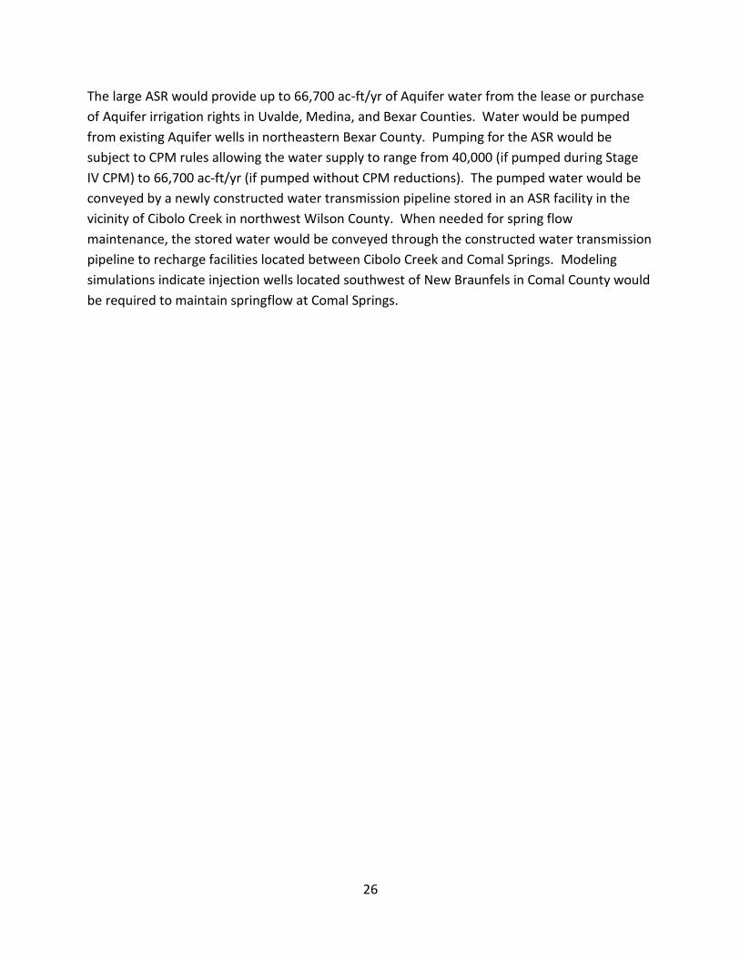
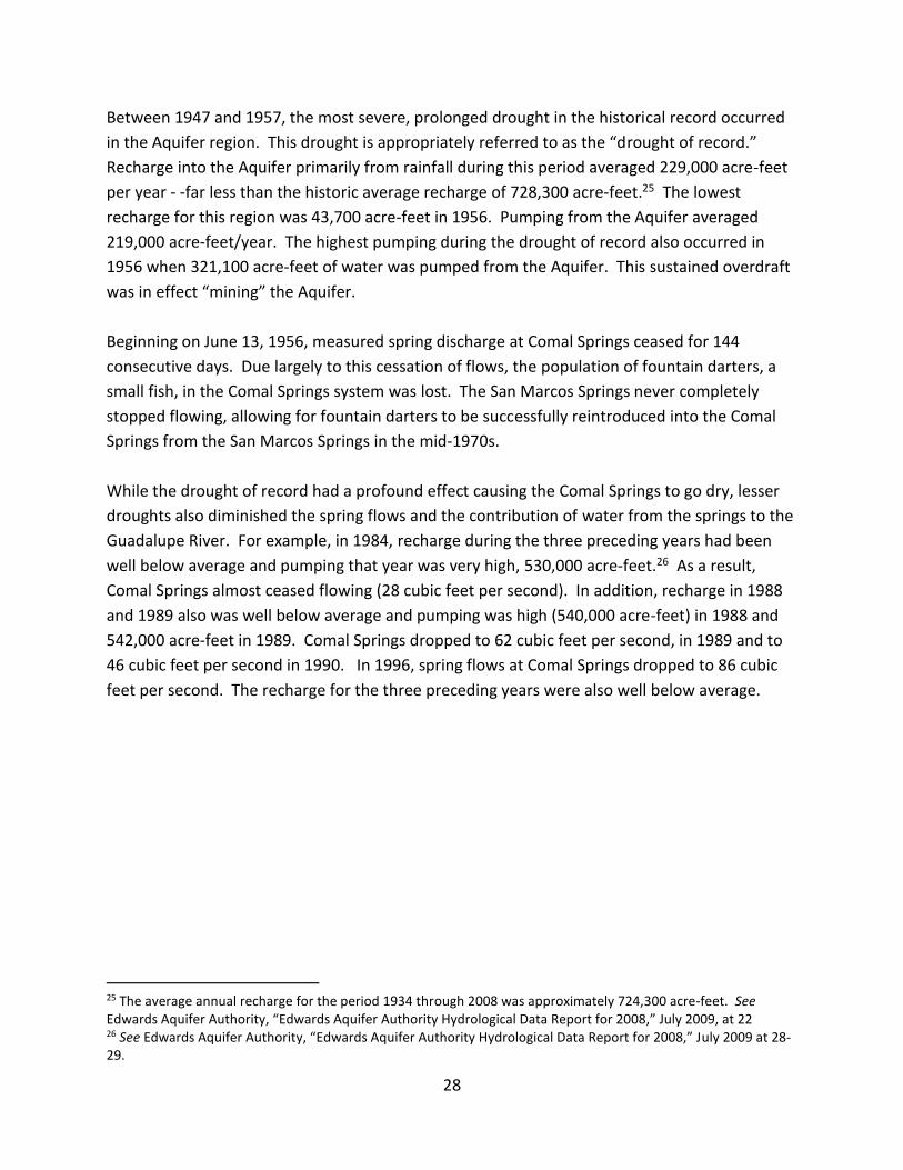