Sustentable Urban Design
134
Prepared for: NYC Department of Design & Construction Ofce of Sustainable Design by Gruzen Samton Architects LLP with Mathews Nielsen Landscape Architects PC June 2008 SUST AINABLE URBAN SITE DESIGN MANUAL
-
Upload
mickadaver -
Category
Documents
-
view
220 -
download
0
Transcript of Sustentable Urban Design

8/12/2019 Sustentable Urban Design
http://slidepdf.com/reader/full/sustentable-urban-design 1/134
Prepared for:NYC Department of Design & Construction Ofceof Sustainable Design by
Gruzen Samton Architects LLP withMathews Nielsen Landscape Architects PC
June 2008
SUSTAINABLE URBAN
SITE DESIGN
MANUAL

8/12/2019 Sustentable Urban Design
http://slidepdf.com/reader/full/sustentable-urban-design 2/134
EXECUTIVE ACKNOWLEDGEMENTSHonorable
Michael R. BloombergMayor, City of New York
David Burney, FAIACommissioner, NYC Department of Design and Construction
DDC Architecture and Engineering Division:David Resnick, AIA, Deputy Commissioner, Structures Division
Margot A. Woolley, AIA, Assistant CommissionerJohn Krieble, RA, Director, Ofce of Sustainable Design
Bruce Hendler, RLA Chief of Landscape ArchitectureKerry Carnahan, Ofce of Sustainable Design
The Sustainable Urban Site Design Manual offers an introduction
to more environmentally, economically, and socially responsible
urban site design practices for New York City capital projects. It is
conceived as a resource handbook, featuring chapters that marry
the unique site conditions encountered on many City projects with
appropriate sustainable site design strategies. The contents are
addressed to the whole rainbow of NYC DDC project participants,
from City administrators to architects and their consultants, to
construction managers, contractors, and facility personnel.

8/12/2019 Sustentable Urban Design
http://slidepdf.com/reader/full/sustentable-urban-design 3/134
sustainable urban site design manual
table of contents
1. Overview page
Introduction 1
NYC Environmental Challenges 2Climate Change and the Future 4
2. Sustainable Sites for DDC
Relevance to NYC Department of Design and Construct ion 9
DDC Site Design Types 10
This is What I Have, so Now What? 12
Sustainable Urban Site Planning 14
How to Use This Manual 18
3. Maximize Vegetation
Issues and Benets 19
Laws, Rules and Regulations 21
LEED™ and Vegetation 22
Key Issues of Planting in NYC 22
Techniques for Maximizing Plant Benets 29
Resources 42
4. Minimize Site Disturbance
Issues and Benets 47
Laws, Rules and Regulations 48
LEED™ and Site Disturbance 51
Key Issues in Minimizing Site Disturbance 51
Techniques for Minimizing Site Disturbance 55
Resources 67
Understanding Soils 68
5. Water Management on Urban Sites
Issues and Benets 75
Laws, Rules and Regulations 76
LEED™ and Water Management 78
Stormwater Management – Key Issues 78
Techniques for Stormwater Management 81
Water Efcient Landscaping – Key Issues 97
Techniques for Water Efcient Landscaping 97
Resources 100
6. Materials in Site & Landscape Design
Issues and Benets 105Laws, Rules and Regulations 107
LEED™ and Site Materials 109
Light-colored Paving and Hardscape 109
Strategies for Incorporating Recycled Materials 111
Specic Techniques and Recycled Materials 113
Resources 124
Planted Roofs: See Separate Document
Please see DDC Cool & Green Roong Manual
available on DDC’s Sustainable Design website

8/12/2019 Sustentable Urban Design
http://slidepdf.com/reader/full/sustentable-urban-design 4/134
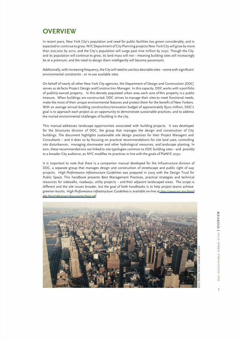
overview
p h o t o : M a t h e w s N i e l s e n L a n d s c a p e A r c h
i t e c t s
8/12/2019 Sustentable Urban Design
http://slidepdf.com/reader/full/sustentable-urban-design 5/134

8/12/2019 Sustentable Urban Design
http://slidepdf.com/reader/full/sustentable-urban-design 6/134
2
d d c s u s t a i n a b l e u r b a n s i
t e s | O V E R V I E W
nyc environmental challenges
Good site design in New York City requires an understanding of the City’s unique conditions and
environmental challenges. The same factors that make NY energy-efcient – e.g. density, public
transportation, extensive infrastructure – make it unsuitable for many typical site planning and landscaping
strategies. Strategies must be tailored the City’s climate conditions, such as cold winters and intense
rainfall events. Often it is not environmental criteria that determine a building’s orientation and placement
on a site, but the street grid, site shape and zoning. Access options are frequently limited. Open areas,otherwise suitable for planting, may be shaded by neighboring buildings.
However, with ingenuity and careful planning, site design can be instrumental in improving the
comprehensive environmental performance of projects, as well as enhancing and restoring urban
ecological systems. DDC strives to encourage site design strategies that not only create beautiful, healthful
properties, but also help to address citywide environmental issues. A summary of these key challenges
follows.
Climate Change: The New York area has already experienced warmer, more unpredictable weather
and rising sea levels. Anticipated impacts from natural forces affected by climate change include
longer periods of heat, drought, more frequent and severe storms, loss of coastal wetlands, beach and
soil erosion, increased localized ooding and water quality degradation. Without action, impacts will
continue to intensify. This manual explores site-related strategies that can help mitigate some of these
conditions.
Urban Heat Island (UHI): Cities are as much
as 5 to 10 degrees hotter than the surrounding
countryside. This phenomenon, known as
the Urban Heat Island effect, results from
several factors, including the relative dearth
of vegetation in cities, the preponderance
of heat-absorbing dark roofs and paving
materials on roads and parking areas, and
the accumulation of hot exhaust gases and
engine heat from cars, trucks and buses.These dark surfaces and lack of vegetation
work together to compound the problem: the
dark surfaces absorb the heat, and the lack of
vegetation limits the natural cooling that the
shade of living plants provide.
The UHI effec t damages the environment in a number of ways. Higher urban temperatures increase the
demand for air conditioning, resulting in higher energy consumption and power plant emissions. When
it is hottest, air conditioners consume much more energy, causing a corresponding increase in the heat
they discharge (rejected heat), which further raises urban temperatures. A hotter City means more air
pollution, because older, less efcient power plants are needed for energy production at peak times, and
ground level ozone is more easily produced at higher temperatures. More heat also means more water use
for infrastructure, landscaping and personal use.
Combined Sanitary / Stormwater Sewer System: New York City is surrounded by water, and its
adjacent rivers and water bodies are particularly vulnerable to both local and regional pollution. Despite
major gains in its water quality over the past few decades, New York City still faces a critical hurdle;
approximately 70% of the City’s 6,300 mile sewer system consists of combined sanitary and stormwater
sewers. These combined sewers become overwhelmed during intense rainfalls, and 27 billion gallons
of “combined sewer overows” (CSOs) are discharged into the City’s receiving waters each year. The
strategies contained within this document can help reduce, control, and treat stormwater runoff as close
to its source as possible so that CSO events and their polluting effects are minimized.
Areas devoid of vegetation (map right) indicate the areas of warmer
temperatures (map on the left)
p h o t o : N A S A

8/12/2019 Sustentable Urban Design
http://slidepdf.com/reader/full/sustentable-urban-design 7/134
3
d d c s u s t a i n a b l e u r b a n s i
t e s | O V E R V I E W
Water Supply: Conserving water within open spaces and planted areas is as important as controlling ow
off-site. New York City relies on over 1.1 billion gallons of water per day supplied from upstate reservoirs;
water conservation is a crucial objective to ensure the long-term viability and supply of our high-quality
water.
Density and Limited Land: New York City is the densest
U.S. city, averaging approximately 27,000 people persquare mile. Consequently, buildable land often comes in
small parcels, on which the building occupies most of the
site. While there is City-owned land in parks and open
areas, most of the projects DDC develops and manages
on behalf of other City agencies are located in urban
neighborhoods. In these circumstances, environmental
site planning requires a neighborhood approach. When
every property has a little bit of open land, signicant
benets are gained when those little bits are linked
together to create one continuous, usable open space.
Continuity and connectivity form natural networks that
support biodiversity, wildlife habitats, soil remediation and
provide hydrologic benets. Even on the most developedsite, where every trace of nature seems to have been obliterated, fragments of land can be joined so that
natural systems can be re-introduced and encouraged. This manual suggests some techniques useful
for small, limited parcels. (Another DDC document, Cool and Green Roong Manual, discusses rooftops as
potential urban open spaces.)
Hostile Plant Environment: The urban environment is stressful for trees and plants. Air pollution,
limited space for root development, poor and compacted soils, physical hazards from people, vehicles,
dogs and bikes, physiological threats from pests, and limited sunlight and water contribute to the
difcult environment in which urban plants try to thrive. Identifying strategies that optimize the viability
and survival of plants and trees is critical to our City’s future. This manual offers sustainable planting
techniques to maximize all types of vegetation including recommendations for soil testing, soil types, root
space requirements, spacing and suggested plant lists for different conditions.
Less than Optimal Soils: Getting trees and plants to
grow in New York City is a challenge. Two of the most
signicant obstacles to plant growth are small soil volume
and compaction caused by competition for root space
with utilities and other subsurface appurtenances, and
the weight of pavement and constant trafc, which lead to
poor soil aeration and drainage. Under these conditions,
trees and plants simply stop growing and become
more susceptible to drought, pests and diseases. Soil
compaction leads to stunted, drought-stressed plants due
to low oxygen concentration, decreased rooting volume,
and moisture irregularity. Compacted soils have lower
inltration rates than undisturbed soils and are more prone
to erosion and sedimentation. On some sites the soil is
further compromised by contaminants, such as acids
and lime, resulting from poor construction and building
maintenance practices, and in some cases the illegal
dumping of hazardous chemicals.
p h o t o : M a t h e w s N i e l s e n
L a n d s c a p e A r c h i t e c t s
Inadequate space for root development
Combined sanitary/stormwater sewer outfall
c o u r t e s y : M e t r o p o l i t a n W a t e r f r o n t A l l i a n c e

8/12/2019 Sustentable Urban Design
http://slidepdf.com/reader/full/sustentable-urban-design 8/134
4
d d c s u s t a i n a b l e u r b a n s i
t e s | O V E R V I E W
An Underground City: In New York City, just as we build “up”
within the bounds of our limited space, we also build “down.”
Subways, tunnels, utilities, communications cables, and water pipes,
all exist below street level in a complicated, dynamic network. Despite
the myriad advantages to building underground, a complex subsurface
condition can create signicant site planning and design constraints
for architects and landscape architects developing projects on thesurface. Given the age and vulnerability of NYC’s sewer and water lines
to vibrations and tree roots, and the potential for construction-related
damage, it is imperative to know what’s under the surface of your site
(and adjacent) in order to avoid damaging critical infrastructure. For
this reason, projects are subject to regulations and review by many City
agencies, particularly the Department of Environmental Protection.
climate change and the future
The following text is quoted from Inventory of New York City Greenhouse Gas Emissions, April 2007:
The term “global climate change” refers to the destabilizing impact on climate and weather patterns that result
from continuous addition of greenhouse gases, the resultant increase in heat energy in the earth’s atmosphere,and the associated changes that follow. Even small changes in the average temperatures can be accompanied
by an increase in severe weather events such as storms and droughts, ecosystem change, loss of animal and
plant species, stresses to human health, and alterations in regional agricultural productivity.
Although climate change is a global issue, the e ffects of rapidly rising temperatures will be felt in ever y local
community. Average temperatures in New York State are projected to increase between 2°F and 8°F by 2100,
with the largest increases in coastal regions such as New York City. Average precipitation is also expected to
rise by 10 to 20 percent, with ex treme wet and snowy days becoming more frequent. Intense weather trends will
be felt on the opposite end of the temperature spectrum, as the occurrence of summer days with temperatures
above 90° are expected to multiply from 14 days in 1997-1998 to 40-89 days by the 2080s.
The list of threats associated with global climate change is alarmingly long, and encompasses effects
on air, water, and vegetation. Certainly not all of them can be addressed within the context of individualprojects, but site designers should recognize potential impacts and design to help mitigate them. The
site strategies offered in this manual take into account pertinent considerations for ecosystem health,
water supply and quality, and the Urban Heat Island effect.
PlaNYC 2030, the City’s strategy for making our city better, more green and more livable, attempts
to reduce NYC’s global warming emissions by 30% with city-wide initiatives that address policy and
infrastructure, and encourage individual building projects to do their part.
climate change and ecosystems
The effects of climate change on biodiversity and ecosystems are impossible to separate from the
effects of other stresses, such as pollution, atmospheric levels of carbon dioxide, land management
and use trends. To date there is no conclusive evidence that climate change alone wi ll have an adverse
impact on the survival of plant and animal habitats. There are examples that many scientists attribute
to global warming, such as the fact that owering plants are blooming about 5 days earlier per decade,
birds are laying eggs sooner, and maple syrup production from sugar maples has shifted from northern
New England to Canada.
In general, global warming has caused the slowly creeping polar migration (northerly for the U.S.)
of a plant or animal’s habitat. Thus climate change could benet certain plant or insect species by
increasing their ranges. The resulting impacts, however, could be positive or negative depending on
whether these species are invasive. For example, climate change could have potentially devastating
p h o t o : M a t h e w s N i e l s e n L a n d s c a p e A r c h i t e c t s
Subsurface utilities limit tree planting

8/12/2019 Sustentable Urban Design
http://slidepdf.com/reader/full/sustentable-urban-design 9/134
5
d d c s u s t a i n a b l e u r b a n s i
t e s | O V E R V I E W
impacts on agriculture and forests if pest species are decoupled from their controlling prey, or if the
ranges of animals responsible for seed dispersal become disjointed.
Climate change will affect individual wetland ecosystems largely through changes in precipitation,
erosion, rising sea level, and temperature uctuations. Wetland plants and fauna are extremely sensitive,
such that even minor variability of moisture storage can adversely affect plant and animal diversity and
microbial activity.
In New York, as well as in other parts of the country, the Climate Zone classication for plant hardiness
has shifted, increasing in NYC from 6A (minimum temperature -10° F) to 6B (minimum temperature
-5° F). This is good news from the standpoint of broadening the range of plant material that can survive
NYC winters. However, plants like poison ivy become more toxic, ragweed produces more pollen,
and Northeastern urban forests may soon have to contend with Kudzu, which has swallowed whole
woodlands in the South.
climate change and water
As a coastal city, New York is particularly susceptible to the effects of global climate change. Rising
sea levels and higher risk of severe oods and storms pose a potentially devastating threat to sites
located within oodplains and sites with deteriorated shorelines. Sea levels along much of the NewYork coast have been rising at an average of ¼ inch per year. If this trend continues, within the next 75
years sea levels surrounding New York will have risen more than 18 inches. Such a rise would result in
complete inundation of areas currently mapped within the 100-year oodplain. Other serious degrada -
tion would occur in coastal wetlands, beaches, fresh water lakes and rivers. The statistical probability
of a “100-year storm” has already become a once in 80 year event and may progress to a once-in-43 year
event by 2020 and by 2050, a once-in-19 year event. Looking ahead, DDC will be taking a more critical
look at sites and building locations near the water and ood plain, recognizing that the effective limits
of the 100-year ood plain are likely to expand. For updated maps of ood-prone areas in New York City,
see the NYC Department of Buildings (DOB) Flood Insurance Rate Maps 2007 on the DOB website.
DEP’s Climate Change Program published its Assessment and Action Plan in May 2008. In this report ,
NYCDEP Commissioner Emily Lloyd states: “The impacts of climate change will be pervasive and pro -
found. Most natural and man-made systems will be affected, and the City of New York’s water supply,drainage, and wastewater management systems are no exception . . . the time to take action is now.”
The City’s water system could be affected by increased evaporation of water due to warmer tempera-
tures, which would reduce river ows and lower lake and reservoir levels, particularly in summer when
demand for water is at its highest. Higher temperatures and more violent storms could lead to increased
turbidity of reservoirs thereby decreasing water quality.
More severe and frequent rainfalls will exacerbate
combined sewer overows (CSOs), causing greater
pollution of surrounding rivers and estuaries. In New
York City, the prevention of combined sewer overows
is already a priority, and there are detention regula-
tions that cover all areas with constrained sewer ca-
pacity. Site and landscape strategies include increas-
ing permeable surfaces, employing bio-retention, and
capturing rainwater for reuse. Specic planning and
design techniques are discussed in the Stormwater
Management chapter, with diagrams and details of
practices.

8/12/2019 Sustentable Urban Design
http://slidepdf.com/reader/full/sustentable-urban-design 10/134
6
d d c s u s t a i n a b l e u r b a n s i
t e s | O V E R V I E W
new york as an urban heat island
As global and local temperatures rise, mitigation of the Urban Heat Island (UHI) effect will become critical
in NYC, as an increase of air temperature of only 6° to 8° F can trigger a range of public health problems,
particularly for children, the elderly and people with respiratory ailments. Also, since NYC chronically faces
shortfalls of electrical capacity at peak demand, the UHI effect encrease the risk of brown-outs or black-
outs.
More vegetation, especially trees, is a key remedial approach for site and landscape architects seeking to
minimize the UHI effect. Plants provide natural cooling in several ways –by providing shade, by utiliz-
ing the sun’s energy in photosynthesis, and, most importantly, by evapotranspiration, which is similar to
perspiration. When plants transpire, they turn water into vapor, dissipating the latent heat of vaporization
and providing cooling.
Though studies (see below) have shown vegetation plays a more important role in UHI mitigation than
light colored surfaces and other physical factors (height, orientation to prevailing winds etc.), these strate-
gies are synergistic when combined with planting. Planting – along streets, in open areas and on rooftops
– combined with other strategies, such as replacing dark surfaces with lighter colored ones, offers more
potential cooling than any other individual site design measure.
NYSERDA, with Columbia University Center for Climate Systems Research & NASA Goddard Institute
for Space Studies, Hunter College Department of Geography, and the Science Applications International
Corp., sponsored a study in October 2006 of NYC’s heat island and ways to mitigate it, entitled Mitigating
New York City’s Heat Island with Urban Forestry, Living Roofs, and Light Surfaces.
Effective city-wide mitigation strategies – identied by NYSERDA in descending order of individual ef -
fectiveness as street trees, living roofs, light-colored surfaces and open space planting – can and should
be used together when possible for DDC projects. Site design and construction strategies that work to
maximize cooling are given special attention in this manual.
Heat Conduction
Between Layers
Heat ConductionBetween Layers
Heat ConductionBetween Layers
ConvectiveHeat Transfer
Pavement Surface
Pavement Base
Pavement Subbase
Subgrade (Ground)
ThermalRadiation
(Infrared)
Reflected Radiation
Wind
Solar Radiation
Demonstration of reectivity, conductivity, and emissivity
that can contribute to the urban heat island effect

8/12/2019 Sustentable Urban Design
http://slidepdf.com/reader/full/sustentable-urban-design 11/134
7
d d c s u s t a i n a b l e u r b a n s i
t e s | O V E R V I E W
urban heat island strategies for ddc
Strategy Mitigation Scenario Reference
Use light colored
surfaces
Use light colored pavement (high albedo)·
Use light roof surfaces·
See DDC Cool & Green·
Roong Manual
See Light Colored Paving in·
Materials chapter
Maximize vegetation -Landscape
Plant street trees·
Plant trees in open spaces and sidewalks·
Maximize other planting and minimize·
hardscapeUse open-grid paving techniques·
See Maximize Vegetation·
chapter
Maximize vegetation -
Living Roof
Use green roof technology· See DDC document Cool &·
Green Roofs
Provide Shade Plant trees·
Use green screens, other plantings·
Locate paved areas in building shadow,·
under overhangs etc.
See Maximize Vegetation·
chapter
Use porous pavement Minimize heat storage through use of·
porous pavements
See Stormwater·
Management chapter
8/12/2019 Sustentable Urban Design
http://slidepdf.com/reader/full/sustentable-urban-design 12/134
8
d d c s u s t a i n a b l e u r b a n s i
t e s | O V E R V I E W
resources
climate change
PlaNYC 2030· A Greener, Greater New York, Mayor’s Ofce of Long Term Planning and
Sustainability, May 2007 http://www.nyc.gov/html/planyc2030/html/home/home.shtml
Inventory of New York City Greenhouse Gas Emissions·
, Mayor’s Ofce of Long-term Planning and Sustainability, April 2007 http://www.environmentaldefense.org/documents/493_
HotNY.pdf
Climate Change Program Assessment and Action Plan, NYC Department of Environmental·
Protection, May 2008 http://www.nyc.gov/html/dep/pdf/climate/climate_complete.pdf
Global Warming & Rising Oceans:· www.actionbioscience.org
Climate Change 2001: Impacts, Adaptation and Vulnerability· www.grida.no
Ecosystems and Biodiversity· http://www.epa.gov/climatechange/effects/eco.html
Effects of Global Warming· http://news-service.stanford.edu/pr/o3/root18.html
“A Wetlands Climate Change Impact Assessment for the Metropolitan East Coast Region”:·
www.metroeast_climate.ciesin.columbia.edu/reports/wetlands.pdf
“Impacts of sea level rise in the New York City metropolitan area” by Vivien Gornitz, Stephen·
Couch and Ellen Hartig, Global and Planetary Changes, Vol. 32, 2002
urban heat island effect
Mitigating New York City’s Heat Island with Urban Forestry, Living Roofs, and Light Surfaces,·
NYSERDA, October 2006
“Cooling the Blacktop” by Meg Calkins. Landscape Architecture Magazine, pp 53- 61. February·
2007.
US EPA Heat Island Reduction Initiative:· www.EPA.gov/heat island/strategies/index.html
“Features Favored by Mother Nature”:· www.concreteparking.org/environmental.htm
“Heat Island Effect”:· http://yosemite.epa.gov/oar/globalwarming.nsf/content/
ActionsLocalHeatIslandEffect.html“Air Pollution Prevention Through Urban Heat Island Mitigation”:· www.ghcc.msfc.nasa.gov/
uhipp/epa_doc.pdf
“Sustainable Site Design Philosophy”:· www.nps.gov/dsc/dsgncnstr/gpsd/ch5.html
“Sustainable Sites: The Case for a Site-Only LEED” by Mike Abbate, The American Society of·
Landscape Architects and the Ladybird Johnson Wildower Center, August 2005.
Cool and Green Roong Manual, NYC Department of Design and Construction, June 2007:·
http://www.nyc.gov/html/ddc/html/design/sustainable_home.shtml
8/12/2019 Sustentable Urban Design
http://slidepdf.com/reader/full/sustentable-urban-design 13/134
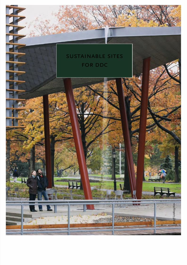
sustainable sites
for ddc
© J e f f G o l d b e r g / E s t o

8/12/2019 Sustentable Urban Design
http://slidepdf.com/reader/full/sustentable-urban-design 14/134
9
d d c
s u s t a i n a b l e
u r b a n
s i t e s
|
D D C
S I T E S
SUSTAINABLE SITES FOR DDC
In New York City, population growth and proliferation of new buildings have increased the need for
ingenuity in site planning and design to maximize the human and environmental benets. The Department
of Design and Construction and other City agencies are taking a leadership role in encouraging and
supporting sustainable site design and landscaping.
All City projects are informed by PlaNYC 2030, the Mayor’s April 2007
comprehensive sustainability plan for a greener, greater New York.
PlaNYC targets ve key dimensions of the City’s environment – land, air,
water, energy and transportation. The intent of this integrated approach
is to help ensure a higher quality of life for future generations, and help
reduce NYC’s global warming emissions. Site and landscape design are
an integral part of the approach and proposed initiatives - specically
those for land and open space, water quality and air quality.
With the enactment of Local Law 86 of 2005, the City now requires
most of its projects to meet the Silver level of the LEED™ certication
process of the U.S. Green Building Council (USGBC), as well as specicenergy and water efciency requirements. Site planning, landscaping
and related material choices can contribute to possible LEED-NC
credits in Sustainable Sites, Water Efciency, Energy & Atmosphere,
and Materials & Resources. Each section of this manual highlights
applicable LEED™ strategies. DDC’s Project Timeline for LEED/Local
Law 86 of 2005 and related documents are available on the DDC’s
Sustainable Design website.
Because DDC’s client base and project port folio present an array of unique site conditions, it is impossible
to offer prescriptive site design solutions here in this manual. Rather, the document is written to provide
a framework for DDC project personnel to discuss and promote sustainable site design principles within
their own projects, and to specically address challenges and obstacles commonly encountered on DDC
projects, such as:
Wide range of sites / wide range of facility types.· DDC’s projects range from buildings on
parkland, to police stations on tight urban lots, to childcare centers with play yards. And as
the City grows, DDC is often forced to build on more problematic properties. No universal
approaches will work, so this manual is organized to address the basic issues, and suggest a
menu of appropriate solutions for different types of sites;
Agency regulations and laws.· City, State and Federal agencies hold jurisdiction over specic
aspects of site design, with a complex network of regulations and laws. Applicable laws are
noted in each section, with reference to more information;
Inexperienced consultants· . Some consultant teams are unfamiliar with sustainable site
approaches. This is due either to inexperience with site/landscape technologies, and/or to the
lack of a professional landscape architect on the Consultant Team. We recommend that each
project have a landscape architect on the design team, and this manual is meant to augmentthe broader team’s knowledge with specic sustainable approaches;
Bad timing.· Often landscape design services lag behind the building concept, whether
because survey information is not available or the landscape architect does not participate
in the early stages of planning and design. A sustainable site approach requires early input
by the landscape architect. It is very important to note that topographic surveys and soil
prole studies are available through DDC at no cost to the project, however, if they’re going to
help guide site design and gain approvals, they must be requested as soon as a client Agency
circulates its scope;
Lack of coordination.· Opportunities are lost, and mistakes made when project team
members do not understand the considerations of each participating discipline.

8/12/2019 Sustentable Urban Design
http://slidepdf.com/reader/full/sustentable-urban-design 15/134

8/12/2019 Sustentable Urban Design
http://slidepdf.com/reader/full/sustentable-urban-design 16/134
11
d d c
s u s t a i n a b l e
u r b a n
s i t e s
|
D D C
S I T E S
Courtyard Building
Characterized by· a protected outdoor area, enclosed or semi-enclosed
by the building. Many serve as recreation areas for the facility’s users.
NYC Examples:· Williamsburg Community Center, Williamsburg Day
Care, El Museo del Barrio, PS 1 Museum, Richmond Hill Group Home;
· Opportunities for sustainable site design include small scale
stormwater ltration devices, using native and drought tolerantplants, use of trees to shade public plaza and west walls; use of high
albedo pavements and those that contain recycled content.
Building Surrounded by Parking
Characterized by· surface parking requirements that leave little site area
for landscaping or outdoor functions;
NYC Examples:· Metropolitan Transportation Authority Corona
Maintenance Facility, 120th and 121st Police Precincts, Queens Hospital
EMS Station, Randall’s Island Fire Training Facility, Rockaway Fire and
EMS Station;
Opportunities· for sustainable site design include deploying stormwater
management strategies requiring minimal site area such as rain
gardens, planters catch basin inserts and inltration swales; maximizevegetation by planting street trees, adding trees to plazas and other
paved surfaces to create shade; using permeable and light-colored
paving, incorporating materials that contain recycled content particularly
for paving systems and site furnishings; minimize site disturbance by
protecting existing trees, staging construction away from future planted
areas and preventing contamination to existing soil areas.
Building on an Irregularly-Shaped Site
Characterized by areas of “leftover” property, and/or awkward circulation
patterns;
NYC Examples:· Sunrise Yard Maintenance Yard, George Vierno
Dormitory, Park Slope Branch Library, Ft. Hamilton Branch Library;
Opportunities· for sustainable site design include saving and maximizingareas of vegetation; introduce pockets of vegetation & trees; employ
various stormwater management techniques; and use of materials
containing recycled content. The opportunities need to be carefully
evaluated based on site shape and the amount of undeveloped land
after the building and site program are dened. Location of the building
on site is key.
Building Adjacent to Water
Characterized by low-lying land, typically comprised of landll and
sloping topography or constructed edge adjacent to a river or estuary;
NYC Examples:· Harper Street Yard on Flushing Bay;
Opportunities· for sustainable site design include maximizing
vegetation as a strategy for shoreline restoration, wetland and ltration
techniques to lter and slow stormwater runoff, various construction
impact mitigation techniques, as well as others that are required by
regulatory agencies.
121st Precinct
El Museo del Barrio
Sunrise Yard
Harper Street Yard
Native plants can be used in all design types, for lower maintenance and more ecological value.

8/12/2019 Sustentable Urban Design
http://slidepdf.com/reader/full/sustentable-urban-design 17/134
12
d d c
s u s t a i n a b l e
u r b a n s i
t e s
| D D C
S I T E S
this is what i have, now what?So, how does this apply to my project? Below are diagrams of the typical site types that DDC encounters,
highlighting conditions common to them. Because all sites are different, review these samples to identify
the site conditions that apply to your project. Relevant site and landscape strategies are listed in the chart
below, showing where more information can be found in this manual.
#1
#2
#3 #5
#6
Buildings on an IrregularShaped Site
FT. HAMILTON BRANCH LIBRARY
#2
#3
#4
#7
#7#2
Buildings on an Irregular
Shaped Site
SUNRISE YARDS
#1
#2
EL MUSEO DEL BARRIO
Courtyard Building
#12
#4
#4#9
#10
HARPER STREET YARD
Buildings Adjacent to
Water
#8
#4
#2
120th STREET PRECINT
Buildings Surrounded by
Parking
#6
#1
#3
#5
BROOKLYN CHILDREN’S MUSEUM
Buildings on an Irregular Shaped
Site
#1
#2
#3#4
#5 #5
#5
#12
#5
QUEENS MUSEUM
Buildings in a Park
#1 #9
#9
#9
#9
Courtyard Building
BRIDGES JUVENILE JUSTICE CENTER
#1
#3 #2#7
#4
121ST PRECINT
Buildings Surrounded by Parking
#1
#5
EL REMSEN AVE. DEP FACILITY
Lot Line Building
#1
#2
#2
#6
#6
PARK SLOPE BRANCH LIBRARY
Buildings on an Irregular Shaped
Site
#1
#12
#3
#8#4
CONGREGATE CARE FACILITY
Buildings on a Campus
#3
#1
PIKE STREET DEP FACILITY
Lot Line Building
#2
#3
#4
#7
#7
OEM HEADQUARTERS
Building with a Plaza
#1
#7
#7 #6
KINGS BRIDGE BRANCH LIBRARY
Lot Line Building

8/12/2019 Sustentable Urban Design
http://slidepdf.com/reader/full/sustentable-urban-design 18/134
13
d d c
s u s t a i n a b l e
u r b a n
s i t e s
|
D D C
S I T E S
this is what i have: typical ddc site conditions
Numbers on the drawings reference numbers on the Site Conditions in the following chart.
# Site Condition Particularly Useful Strategies Refer ToPages
1 Sidewalk Tree pit enhancement; structural soil trenches, recycledcontent in concrete
29-33,43-45,114
2 Entr y plaza Rain gardens, trees for shade; rec ycled content in pavers;structural soil, planters
29-32, 87,88, 91-92,
114, 117
3 Loading dock Catch basin inserts, water quality inserts; recycled content in
asphalt and base aggregates
86, 119, 122,
123
4 Parking and service area Trees for shade, bark beds, inltration areas, recycled
content in asphalt, wheel stops, and base aggregates;pervious pavement
31, 83-84,
86, 89, 116,119
5 Front yard Rain gardens,vegetated buffer, shade trees, inltration
area, bioltration techniques,recycled content in mulch/soil
amendments,habitat enhancement, native plants
34, 40,
85-86, 89,
116, 119
6 Narrow side or rear yard Inltration swales, vegetated buffers; vine screens and
planted walls, recycled content in fencing
34, 38, 90,120
7 Land-locked, ir regular,
“left-over” area
Amended soils, turf alternatives, native plants; retain
existing vegetation; bioltration techniques
34, 36, 61,
62, 85-89
8 Steep terrain Slope reduction bench, tur f alternatives , habitat planting;
minimize site disturbance, erosion and sediment control
40, 58-59,
93
9 Courtyard High-albedo paving; inltration areas; recycled content in
pavers and furnishings; pervious pavement
83-84,
89,109-110,
111
10 Shoreline edge Minimize site disturbance; vegetated lter strip, native
plants, habitat enhancement
40, 55, 85,
86
11 Wetland proximity Minimize site disturbance; native plants, habitat
enhancement; protect existing soils and vegetation,stormwater ltration techniques
40, 55,
60-63,87-94
12 Campus condition Amended soils, turf alternatives, native plants; retainexisting vegetation; bioltration techniques
34, 36,61-62, 85,
86
V* Previously paved Recycled concrete aggregate or asphalt as base for new
pavement or backll
122, 123
V* Shallow rock or
impermeable soil
Underdrained bioretention, detention structures; reuse of
rock or crushed rock aggregate in landscape and subbase
89-94, 123
V* Elevation change at entry Planters; recycled content in mulch and soil amendments 87, 88, 118,
121
V* Perimeter enclosure Vine screens, planted wal ls, windbreak/planted buf fer 37, 38-39
V* = Various sites

8/12/2019 Sustentable Urban Design
http://slidepdf.com/reader/full/sustentable-urban-design 19/134

8/12/2019 Sustentable Urban Design
http://slidepdf.com/reader/full/sustentable-urban-design 20/134
15
d d c
s u s t a i n a b l e
u r b a n
s i t e s
|
D D C
S I T E S
required in these districts; a 20 foot rear yard is required above the ground oor. In many cases, buildings
do not use the entire potential “as of right” footprint space, but even at almost or full coverage there are
sustainable landscape techniques that can improve the overall environmental performance, such as street
trees, planters, vine screens, and planted roofs.
integration with the site planning process
DDC provides its consultants with the Design Consultant Guide
[http://www.nyc.gov/html/ddc/html/desguide.html], which is a checklist of services and deliverables, as
well as description of qualitative expectations for a project’s milestones. This Sustainable Urban Site
Design Manual is intended to follow those established tasks and milestones, but not to alter or modify
the contractual responsibilities described in the Design Consultant Guide. Outlined below are suggested
tasks, linked to DDC’s phases of the design process, that will facilitate sustainable site design.
inventory and analysis phase
The Site Inventory Phase of a building design project investigates,
quanties, and documents the existing site characteristics and its
context. The architect, landscape architect and engineers can analyze
and use this data as the factual basis for land use and site designdecisions. For a sustainable approach to site planning and design, we
present these additional considerations:
Testing.· Before beginning the design process, the consultant must request and obtain test results
on the existing soil. By code, new building plans must include borings that quantify the site’s soils
proles. However this information does not provide information on many other aspects of the
site’s underlying soil. Sustainable hydrologic and landscape planning also must be premised on
tests that evaluate and document the chemical, biological and hydrologic characteristics of the
site’s soils. These tests will aid in determining landscape/planting and stormwater management
and design strategies as well as the budgets for these components. See “Soil Tests” in the
Minimize Site Disturbance chapter for descriptions of suggested tests. Also refer to the USDA
Soil Classication System [http://soils/usda.gov/technical/classifcation/taxonomy]. DDC has
in-house groups that conduct subsurface investigations and provide topographic surveys atno additional cost to the project. The agency’s Project Managers are asked to request an up-
to-date survey and geotechnical proles immediately upon receipt of a project’s scope from a
client agency. If these investigations haven’t started by the time a project consultant has been
identied they should request them immediately. In this way, the studies can be done by DDC
while the consultant’s contract is being nalized and registered;
Topography.· Understanding topography is essential not only for building placement, but also to
plan for drainage and minimize earthwork and disruption to existing site vegetation;
Existing Vegetation:· Vegetation needs to be assessed for its quality and viability. Many sites
contain invasive species and monocultural stands of trees. Other sites have mature trees and
signicant areas of healthy vegetation. Whatever the case, site vegetation needs to be identied
and mapped. Sustainable site planning techniques mandate the retention of as much existing
native vegetation as possible and the protection of these areas from construction impacts;
Microclimate.· In order to help determine the best opportunities for passive solar design and
natural ventilation, diagrams of sun and wind patterns are important to generate before the
nal building location is determined. Remember that the “north-south” orientation of the
Manhattan street grid is only a convenience, and the real orientation is shifted approximately
29° from true north toward the east;
Shorelines and Wetlands.· Development near aquatic areas must be based on an extensive
understanding of sensitive resources and processes. Sites in close proximity to shorelines
or wetlands are tightly controlled by federal, state and local regulations. Consult these before
doing anything!
The DDC Project Manager
should start the site survey
and subsoil investigationwhile waiting for project to be
registered.

8/12/2019 Sustentable Urban Design
http://slidepdf.com/reader/full/sustentable-urban-design 21/134
16
d d c
s u s t a i n a b l e
u r b a n s i
t e s
| D D C
S I T E S
pre-schematic design phase
During DDC’s Pre-Schematic Design Phase, the basic concept of the building is established, after
exploring alternatives and setting design goals. For a sustainable approach, we present these
additional considerations:
Sustainable Design Workshop:· When the results of the site inventory and analysis are available
and the design program has been established, this meeting should be the rst work session –and it must include all the consultants and the client group. Sharing site evaluation information
will inform the team, and reveal sustainable design opportunities. Some typical site-related
discussion items are below.
Use the Site Wisely:· Review and organize site activities such as public spaces, utility corridors
and parking to reduce the building and paving footprints. Limit site disturbance to the minimum
area necessary and coordinate with available infrastructure (utilities and streets). Dene utility
corridors early in the design process and coordinate these with any other program elements that
will result in site disturbance.
Drainage Patterns:· In our highly urbanized environment it may not be immediately apparent
that there is a natural drainage pattern, other than what can be seen owing into the nearest
storm drain. On every site there is room for improving the management of its stormwater,
whether by creating vegetated areas to capture, detain and lter runoff, by using permeable
pavement or green and blue roofs to slow runoff, or by using detention tanks.Solar Orientation:· In NYC’s climate, the shoulder seasons of early spring and late autumn
are times when we most enjoy the sunshine. However, in warmer seasons, the site-related
concerns are heat gain, re-radiation of heat into the atmosphere and the energy required to cool
interiors heated by the sun. Optimizing the building’s orientation and associated exterior public
spaces can take maximum advantage of solar orientation to provide shade over such surfaces as
parking and roads that contribute signicant heat gain. Coordinate this site-related orientation
analysis with the study of building orientation as it relates to daylighting and interior glare.
Wind and Climate:· Characteristics of the local microclimate need to be considered when
locating new structures and exterior public spaces. This will maximize human comfort and
reduce energy usage for heating and cooling. Prevailing winds should be used as natural “air
conditioning.” Assess the impacts of the new structure(s) on wind movement so as not to
create channels that accelerate the wind (Venturi effect).
Vegetation:· Discussion of building location and footprint should consider the ndings on
vegetation – those areas to be protected, shade and micro-climate, relationship to neighboring
open space (habitat linkage) and any areas of contamination to be mitigated.
design and construction document phases
The development of the site design and landscaping will vary greatly during the design development and
document phases, depending on the nature and scope of the project. For a sustainable approach on all
projects, we present these additional considerations:
Drawing Coordination:· The site
survey and the project drawings should
be set up using a common coordinatesystem before they are distributed as
base plans to the consultants. The
architect, civil engineer and landscape
architect should collaborate on this –
otherwise the project runs a high risk
of encountering progress-delaying
surprises. The architect should not
distribute oor plans that are not
referenced to the survey.
121 st Police Precinct, Staten Island, NY R a f a e l V i n o l y A r c h i t e c t s P C

8/12/2019 Sustentable Urban Design
http://slidepdf.com/reader/full/sustentable-urban-design 22/134
17
d d c
s u s t a i n a b l e
u r b a n
s i t e s
|
D D C
S I T E S
Utilities:· Coordinate the placement of new utilities with areas of the site to be protected, e.g.
trees, vegetation, natural topography. This should be done during the design development
phase, when the engineers are beginning to lay out the utility lines across the site. Review the
sewer capacity and drainage plan with DEP requirements to ensure that stormwater conveyed to
the sewer system does not exceed the allowable ow and that the project will achieve required
connections.
Site Access:· Vehicular access into a site is a critical decision that needs to be made at the outset,
both to minimize paved areas and plan for drainage and plantings. Use the planned permanent
road as the construction access route.
Vegetation:· Choose plants that are suited to the site conditions and can better survive in them.
City agencies come to DDC for design and construction assistance, but they operate and maintain
their own buildings, so match the plant palette to the maintenance capabilities of the users.
Plan for Construction:· During Contract Document [CD]
production, prepare a site protection and site demolition plan
that species the protection of selected specimens or areas of
site vegetation, street trees, environmentally sensitive areas,
and areas susceptible to erosion. Require the contractor todevelop and implement a plan for the recycling of construction
waste. If the site is occupied by a structure or paving, specify
the reuse, salvage or recycling of materials. Prepare an erosion
and sediment control plan per the NY State Department of
Environmental Conservation (NYS DEC) and the requirements
of USGBC LEED™ system.
Materials for Landscaping and Construction:· Specify
environmentally preferable products. The composition of materials used in site construction
is a major factor in their life-cycle environmental impact. During the design development and
construction document phases, research and specify products that maximize recycled content,
materials harvested on a sustained yield basis and assemblies that can be easily deconstructed
at the end of their useful lives. Give preference to locally produced products and other productswith low embodied energy content. Eliminate the use of materials that pollute or are toxic during
their manufacture, use or reuse. Consider trade-offs among life-cycle stages (i.e. raw materials
acquisition, manufacturing, transportation, etc) when determining environmental preferability.
Think about the big picture rather than simply shifting problems from one life-cycle stage to
another.
construction phase
The construction phase is a critical phase that requires vigilance on the part of the designer and the DDC
project manager. For a sustainable approach, we present these considerations:
Be vigilant in the enforcement of specied site protection techniques;·
Keep an eye out for eld changes to utilities that may alter excavation paths that could adversely·
impact existing trees;
Maintain good lines of communication with the construction manager and/or construction·
superintendent to protect existing and future planted areas from compaction and soil
contamination from construction activities;
Stay alert to the construction schedule to ensure soil tests are submitted and approved in a timely·
manner, that plant material is tagged and ready for installation during the correct planting seasons
and that subsurface and adjacent construction is complete before installing plant material;
Don’t abandon the plants after the project is nished: work together with the client agency/·
end user of the site to be sure there are procedures in place to allow the plants to become well
established, watered and replaced, if necessary, during the guarantee period.
M a r b l e F a i r b a n k s A r c h i t e c t s a n d S c a p e
Glen Oaks Branch Library, Queens, NY

8/12/2019 Sustentable Urban Design
http://slidepdf.com/reader/full/sustentable-urban-design 23/134
18
d d c
s u s t a i n a b l e
u r b a n s i
t e s
| D D C
S I T E S
how to use this manualThis manual is intended for both project managers and design consultants who may not have extensive
experience with site design and landscape architecture, as well as landscape architects who may not
be wholly familiar with the unique conditions and challenges often encountered on NYC projects. The
Overview, Chapter 1, outlines the key issues inherent in urban sites and specically addresses techniques
to mitigate the Urban Heat Island effect. This Chapter, Sustainable Sites for DDC, notes typical site designtypes and lists useful landscaping strategies that are commonly encountered by the City agency. Chapter
3, Maximize Vegetation, offers an overview on the benets of vegetation in the urban environment and
a variety of techniques to maximize vegetation. Chapter 4, Minimize Site Disturbance, discusses how
minimizing site disturbance can save time, money and valuable resources. Chapter 5, Water Management
on Urban Sites, explores issues and strategies related to stormwater management and water efcient
landscapes. Finally, Chapter 6, Materials in Site & Landscape Design, focuses on strategies for incorporating
recycled materials in site features and site construction.
Each chapter is organized in a similar manner, and contains diagrams, specications, construction
details, lists of resources, plant lists, etc. as appropriate to the chapter’s content. Typical chapter
organization is the following:
Topic overview and benets of a sustainable approach·
Laws, rules and regulations·
LEED™ relevance·
Key issues·
Techniques for implementation·
This document is not meant to be a primer on site and landscape planning, but to highlight those
approaches, specic techniques and materials that will make your project more green.

8/12/2019 Sustentable Urban Design
http://slidepdf.com/reader/full/sustentable-urban-design 24/134
maximize
vegetation
p h o t o : M a t h e w s N i e l s e n L a n d s c a p e A r c h i t e c t s
8/12/2019 Sustentable Urban Design
http://slidepdf.com/reader/full/sustentable-urban-design 25/134
19
d d c
s u s t a i n a b l e u r b a n
s i
t e s
| M
A X I M
I Z E
V E G E T A T I O N
Bioswale – Potsdam Park
p h o t o : M a
t h e w s N i e l s e n L a n d s c a p e A r c h i t e c t s
MAXIMIZE VEGETATION
Every DDC project offers the opportunity to plant trees and other vegetation and/or to protect those
already on the property. Among many other benets, planting trees and other vegetation in the urban
landscape provides shade for cooling, cleans the air, and creates pleasant spaces. However, the urban
setting is stressful for trees and plants. Pollution, restricted planting areas, poor and compacted soils,
physical hazards, pests, limited sunlight/water and vandalism are some of the factors that can reduce thesuccess rate of vegetation in New York City. The planting strategies contained in this chapter can help
mitigate the stresses on vegetation and ensure their longevity and effectiveness.
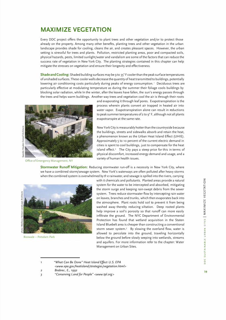
Shade and Cooling: Shaded building surfaces may be 9 to 35° F cooler than the peak surface temperatures
of unshaded surfaces. These cooler walls decrease the quantity of heat transmitted to buildings, potentially
lowering air conditioning costs particularly during peaks of energy consumption.1 Deciduous trees are
particularly effective at modulating temperature as during the summer their foliage cools buildings by
blocking solar radiation, while In the winter, after the leaves have fallen, the sun’s energy passes through
the trees and helps warm buildings. Another way trees and vegetation cool the air is through their roots
and evaporating it through leaf pores. Evapotranspiration is the
process wherein plants convert air trapped in heated air into
water vapor. Evapotranspiration alone can result in reductions
to peak summer temperatures of 2 to 9° F, although not all plants
evapotranspire at the same rate.
New York City is measurably hotter than the countryside because
the buildings, streets and sidewalks absorb and retain the heat,
a phenomenon known as the Urban Heat Island Effect (UHIE).
Approximately 5 to 10 percent of the current electric demand in
cities is spent to cool buildings, just to compensate for the heat
island effect.2 The City pays a steep price for this in terms of
physical discomfort, increased energy demand and usage, and a
variety of human health issues.
Stormwater Runoff Mitigation: Reducing stormwater run-off is a necessity in New York City, wherewe have a combined storm/sewage system. New York’s waterways are often polluted after heavy storms
when the combined system is overwhelmed by the rainwater, and sewage is spilled into the rivers, carrying
with it chemicals and pollutants. Planted areas provide a natural
system for the water to be intercepted and absorbed, mitigating
the storm surge and keeping rain-swept debris from the sewer
system. Trees reduce stormwater ow by intercepting rain water
on leaves, branches and trunks, which then evaporates back into
the atmosphere. Plant roots hold soil to prevent it from being
washed away thereby reducing siltation. Deep rooted plants
help improve a soil’s porosity so that runoff can more easily
inltrate the ground. The NYC Department of Environmental
Protection has found that wetland acquisition in the Staten
Island Bluebelt area is cheaper than constructing a conventionalstorm sewer system.3 By slowing the overland ow, water is
allowed to percolate into the ground, traveling horizontally
below the ground before slowly seeping into wetlands, streams
and aquifers. For more information refer to the chapter: Water
Management on Urban Sites.
Ofce of Emergency Management, NY
S w a n k e H a y d e n C o n n e l l A r c h i t e c t s
1 “What Can Be Done” Heat Island Effect U.S. EPA <www.epa.gov/heatisland/strategies/vegetation.html>2 Brabrec, E., 1992
3 “Conserving Land for People” <www.tpl.org>

8/12/2019 Sustentable Urban Design
http://slidepdf.com/reader/full/sustentable-urban-design 26/134
20
d d c
s u s t a i n a b l e u r b a n
s i t e s
| M
A X I M
I Z E
V E G E T A T I O N
Pollution Mitigation: Plants play an important role in reducing particulate and gaseous pollutants in the
air, including carbon dioxide and sulfur dioxide, by absorbing them through their leaves and other plant
parts. Particulate matter clings to branches, tree trunks, and leaves and is washed into the soil. Trees
absorb other noxious fumes such as carbon monoxide and sulphur dioxide without tree damage.
The Neighborhood Tree Survey, a 2002 tree-by-tree study of three NYC
neighborhoods, found that just three-hundred-twenty-two (322) streettrees remove about 4.3 metric tons of carbon and 228 kg of other pollutants
annually. This study, available on the Open Accessible Space Information
System (OASIS), was conducted by several partner organizations: USDA
Forest Service; SUNY School of Science and Forestry; Community Mapping
Assistance Project; Environment of NYC; Trees New York and Environmental
Systems Research Institute. For more information see www.oasisnyc.net.
In 2007 the NYC Department of Parks and Recreation completed its street
tree count; there are now 592,103 street trees, a 19% increase since the last
5-borough count in 1995. For a complete inventory and analysis of ndings,
go to the Parks website for the tree count summary.
Wind Mitigation: Tall buildings create pathways of high wind velocity
(wind tunnels). Vegetated buffers disrupt those straight pathways.Windbreaks function by reducing air movement for 10 to 15 times the height
of the windbreak, reducing the velocity by as much as 50%. Prevailing
winter winds in the NYC area come from the north and northwest. The
most effective windbreaks are planted in U or L shapes and extend about
50 feet beyond each corner of the area to be protected. Although a single
row of low branching trees provides some benet, several rows of trees
underplanted with evergreen shrubs is the most effective, with the buffer
remaining dense to the ground level.
Respite and Habitat: Planted areas are treasured green resources in
dense, bustling urban areas like NYC, whether they are recreational parks,
shaded trees along the street or a private garden view. Interaction with
plants has been demonstrated to improve human psychological health
and physical well-being. More planted areas, especially if they are linked
or near others, attract and support birds, butteries and wildlife.
Urban Planting For Positive Environmental Benets: Trees and plants
benet the urban environment in several ways:
Trees are effective in shading common urban paved surfaces, particularly parking lots, plazas,·
sidewalks, and roads, which if left unshaded, contribute to the Urban Heat Island Effect. Refer
to Technique: Structural soils, tree trenches.
Plantings can cool buildings by using shade trees or vertical vine screens on the southeast or·
southwest exposures. Refer to Technique: Vine screens and trees for shade.
Vegetation contributes biomass (leaves, branches and other plant components in layered·
planting
that help clean air pollutants from the atmosphere. Refer to Technique: Biomass
Ground covers ahouls replace lawns to reduce pesticide, fertilizer and fungicide use that pollute·
soil and water, using disproportionate amounts of potable water. Refer to Technique:
Lawn alternatives.
Plantings can slow wind velocity, potentially lowering heating costs. Refer to Technique:·
Windbreak.
Plantings reduce runoff and the frequency of combined sewer overows, and help cleanse·
stormwater. Refer to the chapter: Water Management on Urban Sites for strategies to introduce
bioswales, rain gardens and other techniques that detain and lter urban runof f.
Plantings create habitat for birds and benecial insects. Refer to Technique: Plants for Habitat.·
Plantings promote human comfort, of fering shaded areas, buffering from noise and trafc,·
stimulation of the senses and positive psychological benets.
trees and pollutionmitigation
One mature tree produces as much oxygenas is inhaled by a family of four in one
year. An average tree stores 13 pounds of
carbon; one acre of urban forest absorbs 6tons of carbon dioxide and puts out 4 tons
of oxygen; 17 trees absorb enough carbon
dioxide annually to compensate for a car
driving 26,000 miles.
Greenwich Streetscape
p h o t o : M a t h e w s N i e l s e n L a n d s c a p e A r c h i t e c t s

8/12/2019 Sustentable Urban Design
http://slidepdf.com/reader/full/sustentable-urban-design 27/134
21
d d c
s u s t a i n a b l e u r b a n
s i
t e s
| M
A X I M
I Z E
V E G E T A T I O N
laws, rules and regulationsThe design team should be aware of the many regulations that cover the selection, planting and removal of
trees and other vegetation. City and State agencies promulgate these regulations for a variety of reasons –
to promote ecological diversity, encourage species survival and protect other vegetation from pests.
summary – laws, rules and regulations
See web links below for more information. This is a summary of key regulations, not necessarily all that may
apply.
agency law, rules, and regulations 2008 applicability
NYC Department of Parks &
Recreation
Restitution or replacement required if trees
are removed;Street tree planting permit; Tree species,
tree pit sizes, soil types and locations
within sidewalks;NYC DPR Tree Planting Standards
Street trees; trees on NYC
Parkland
Quarantine zones for Asian Long Horned
Beetle limit tree species allowed
Identied zones in Queens
Brooklyn, Manhattan – DPR or
DOT land only
NYC Department of Design &Construction
Tree restitution pending;Quarantine zones in all boroughs of DDC
managed projects
Trees damaged in construction;All projects managed by DDC
NYC Department of City
Planning
Special Natural Area Districts require
special protections
Areas and requirements identi-
ed in NYC zoning resolution
ZR Article II, Chapter 5 and Article IV,
Chapter 4: Accessory Off-Street Parkingand Loading Regulations
Perimeter and interior landscap-
ing for commercial and commu-nity facility off-street parking lots
ZR Article II, Chapter 3: Street TreePlanting in Commercial Districts
Quantity of street trees requiredbased on frontage
ZR Article II, Chapter 6: Special UrbanDesign Guidelines -- Streetscape
Developments in R9 and R10Districts with private road and
street tree planting
NYS Department of
Environmental Conservation
Reporting Law;
Annual Report for Restricted Pesticides
Use of pesticides on plant mate-
rial during (& after) construction
NYS Department of
Transportation
Native plants required for 85% of plant
species
Projects that utilize Federal
funding on DOT land
NYS Department of
Agriculture and Markets
Established quarantine zones for ALB in
Brooklyn and Queens effective March
2002
Quarantine areas; extent of
quarantine zones in constant
ux. Refer NYCDPR web site forupdated information
NYC Department of
Transportation
Sidewalk clearances require approval Street trees

8/12/2019 Sustentable Urban Design
http://slidepdf.com/reader/full/sustentable-urban-design 28/134
22
d d c
s u s t a i n a b l e u r b a n
s i t e s
| M
A X I M
I Z E
V E G E T A T I O N
Web links – Note that full regulations not always available on-line.
NYC Department of Parks & Recreation
http://www.nycgovparks.org/sub_your_park/trees_greenstreets/beetle_alert/beetle_alert.html
http://www.nycgovparks.org/sub_permits_and_applications/images_and_pdfs/street_tree_planting_permit_
guidelines.pdf
NYC Department of Design & Construction
NYC City Planning http://www.nyc.gov/html/dcp/pdf/zone/art10c05.pdf
NYC Department of Environmental Conservation
NYS Department of Transportation http://dot.state.ny.us/tech_serv/mat/manuals/murkp2amim.pdf
leed and vegetationWith the enactment of Local Law 86 of 2005, the City now requires
most of its projects to meet the Silver level of the LEED certication
process of the U.S. Green Building Council (USGBC), as well as
specic energy and water efciency requirements. Maximizing
vegetation contributes to credits in Sustainable Sites, specically
for protecting and restoring habitat, and for helping to mitigate
the heat island effect with the shading qualities of plants. Water
Efciency credits may be achieved by reducing or eliminating theuse of potable water in irrigation, with a high efciency irrigation
system, no irrigation or the use of on-site rain water or waste
water.
key issues of planting in nycselecting plant species
To achieve the many vegetation benets, the designer needs to
understand several key issues that affect plant selection.
Microclimate: Microclimate is the suite of climatic conditions measured in localized areas near
the surface. These environmental variables, which include temperature, light, wind speed, slope andmoisture, provide meaningful indicators for plant selection and sustainable ecological communities.
The built environment plays a major role in determining a site’s microclimate. Existing and proposed
structures can have negative impacts by casting dense shade, accelerating wind velocities, and raising
ambient temperatures due to heat gain. Conversely, the built environment can provide positive impacts
by contributing reected sunlight or decreasing wind velocities.
In planning for plant selection, the designer needs to conduct a pre and post-site analysis of these factors
to ensure that plants are properly located to mitigate or take advantage of microclimatic conditions.
Size Matters: Plants living in close proximity make demands on the same resources, in some instances
causing destructive competition, and in others creating benecial interactions. Plant roots compete for
nutrients and moisture while foliage competes for sunlight. Understanding a plant’s mature natural
structure (root spread and canopy height and habit) will help determine the amount of space it requires
to develop into a healthy specimen.
Plant selection is typically done by starting at “the top” – locate canopy trees rst, draw their mature
height and branching spread, then draw a section to evaluate the vertical relationships. If it is a high
branching tree, then smaller, understory trees or shrubs tolerant of dappled shade can be planted within
its canopy. Lower branching trees or shrubs may allow shade tolerant herbaceous plants to be located
within their spread, and so on. This is called biotope-based planting arrangement along the light-shade
continuum and mimics the distribution of plants found in natural environments. For example, in south or
west-facing conditions, taller plants can provide needed shelter for shade-loving ground covers.
LEED credits
Maximizing vegetation can contribute to the
following LEED credits:Sustainable Sites:
Credit SS 5.1 Site Development
Protect or Restore HabitatCredit SS 5.2 Site Development
Maximize Open SpaceCredit SS 7.1 Heat Island Effect
Non-roof Credit SS 7.2 Heat Island Effect – Roof
Water Efciency:
Credit WE 1.1, 1.2 Water Efcient LandscapingReduce by 50% or 100%
Credit WE 2 Innovative Wastewater
Technologies

8/12/2019 Sustentable Urban Design
http://slidepdf.com/reader/full/sustentable-urban-design 29/134
23
d d c
s u s t a i n a b l e u r b a n
s i
t e s
| M
A X I M
I Z E
V E G E T A T I O N
Available planting space is most critical for canopy trees.
Tree branches can cause damage to building facades,
and tree roots can heave pavements or compromise
utilities. Falling branches and leaves damage roofs
and clog gutters, so proper spacing between adjacent
structures and trees is the rst priority. The second
priority is the spacing between large trees; to allow a treeto develop its natural form, it should not be crowded by
another tree of equal height and spread.
For smaller plants, it is also important to know their
mature height and spread, because in general, the foliage
mass is comparable to the root spread. This information
can be used as a guide to spacing smaller plants without
creating destructive competition. Placing smaller plants
in the vicinity of canopy trees is more difcult to assess
as major tree roots far exceed their canopies and they are
more effective at extracting nutrients and moisture than
the shallow roots of smaller plants.
Functional Considerations: Trees and plants can be used to solve site-specic problems, such as light
pollution or glare, local noise issues, or wind tunnels. Based on the site analysis and building location,
plant selection should be tailored to solving or improving site conditions. For example, placing shade
trees or vine screens on west facing exposures can reduce cooling loads. Steep slopes can be stabilized
using aggressive, brous rooting shrubs or ground covers. Judiciously placed evergreens can be located
around parking lots to protect lower oor occupants from the glare of headlights. Trees in particular are
very effective at shading pavements, thereby reducing the urban heat island in addition to contributing
biomass that serves to reduce air pollution.
Human Comfort: Many of the functional capabilities of plants also result in benets to people. Plant
selection should strive to include plants that have noticeable characteristics in all four seasons. Spring
is the opportunity to introduce perennial bulbs, owering trees; summer lends itself to strong colors and
fragrance-emitting owers; fall suggests use of herbaceous plants with persistent seed heads or trees thatturn dramatic colors, and winter is a time to appreciate bark textures and evergreens.
Plant Choices: There are tens of thousands of plants to choose from that are adapted to the New York
climate (Zone 6A or B as classied by the USDA based on minimum recorded temperature). In recent
years, there has been growing interest in using native or naturalized species. Native species are dened
as those naturally occurring in a dened area prior to European settlement. Naturalized species are those
that are not native but reproduce and maintain themselves without human intervention. Exotic plants
are not naturally occurring, presently or historically, in any ecosystem in the United States. All these may
be attractive and have the habitat-enhancing characteristics that attract birds and insects. However,
native species in general are better adapted to local climate, soils, rainfall patterns and thus require less
supplemental water, fertilizer, and are more resistant to pests and disease. Use of primarily native species
results in lower maintenance costs, water usage, harmful chemicals that can pollute water sources, and is
a more sustainable strategy for connecting habitat patches.
Biotope planting arrangement
p h o t o : M a t h e w s N i e l s e n L a n d s c a p e A r c h i t e c t s

8/12/2019 Sustentable Urban Design
http://slidepdf.com/reader/full/sustentable-urban-design 30/134
24
d d c
s u s t a i n a b l e u r b a n
s i t e s
| M
A X I M
I Z E
V E G E T A T I O N
asian longhorned beetle and other pests
The Asian Longhorned Beetle (ALB) is a species of Anoplophora, a cerambycid beetle. It was introduced to
this country around 1990 from China, probably within solid wood packing material, and was rst discovered
in New York City in 1996. They have been intercepted in ports and warehouse sites throughout the US. ALB
range from ¾” to 1-1/2” inches in size with antennae in length from 1 to 2.5 times their body length. Both
sexes have up to 20 irregularly distinct white spots.
The beetle has a 1 year life cycle, which it completes within
particular hardwood species. It is destructive to the tree during all
phases of its life cycle but the greatest damage occurs during the
fall and winter larval stage when the beetle tunnels through the
tree, including the heartwood. An infestation of Asian Longhorned
Beetle is 100% fatal to the tree it infests. However, the beetle
infests only certain hardwood species, called host species, and
consistently ignores non-host species trees. Typical host species
include all maples, ash, elms, London plane tree, hackberry, horse
chestnut, poplars, alder, birches, mountain ash, willows and box
elder. Unfortunately, the list of hosts is not static, and species are
occasionally added and removed. See below for references.
Avoidance is the primary strategy for controlling this destructive
pest and preventing its spread to other trees, because there is no
effective treatment at this time. ALB ies or spreads through the
transport of host material to new sites.
An affected tree can be detected in several ways -- the web site of the NYC Department of Parks and
Recreation describes them with photos. Once detected, an infested tree must be immediately cut, chipped
and incinerated. If an infested tree is suspected on a property, call the USDA APHIS hotline at 1-877-STOP-
ALB. An ALB inspection should become part of an initial site survey for DDC projects.
Quarantine Zones in New York City have been established by the U.S. Department of Agriculture’s Plant
Health Inspection Service to slow the spread of the pests. No one may plant host species within the
quarantine zones. In May 2007, NYC DPR established quarantine areas in much of Brooklyn, Queens, and
Manhattan. The Bronx and Staten Island are currently outside the quarantine area, although a planned area
has been designated on Staten Island. NYC’s Department of Design and Construction considers locations
of all its managed projects as quarantine zones.
Quarantine zones and the restrictions on planting host species is a much-debated topic. While USDA
APHIS regulations do not prohibit the planting of host species, NYC Department of Parks and Recreation
discourages the planting of host species to minimize future tree loss. The goal of the quarantine zones
is to limit transport of ALB and host material, and manage disposal. While the ALB quarantine zones are
designed to be of sufcient size to limit adjacent plantings, the quarantine zones are only as effective as
the public’s understanding of these zones.
Plant diversity is an important strategy that the designer can employ to help prevent the spread of theALB and other plant pests, because the beetle chooses host species and avoids non host species. Non-
host species include: Arborvitae, Baldcypress, Linden, Oak, Catalpa, Dawn redwood, Hornbeam, Ginkgo,
Juniper, Kentucky coffee tree, Tulip Poplar, Serviceberry, Honeylocust, Turkish lbert and Sweetgum.
Recent pest breakouts in other states are compelling demonstrations of the importance of planting a
variety of species. In 2001, the Citrus Longhorned Beetle (Anoplophora chinensis) was discovered in
Washington State and Emerald Ash Borer was discovered in both Michigan and Ontario in 2002, resulting
in tree removals in the millions. Because we tend to plant trees of similar species along streets and in
our public spaces, when the pests hit, all of the species are often affected, resulting in barren streets and
gaping holes. Planting a diversity of species ensures that some vegetation will remain when an endemic,
like a major pest infestation, occurs in the future.
c o u r t e s y : U S D A F o r e s t S e r v i c e
Asian Longhorn Beetle8,000 infested trees have been removed from the
NYC metropolitan area 1996-2004. London Plane
trees and Norway Maples, host species, accountfor 41% of NYC’s street trees. There are no
treatments for Asian Longhorn Beetle infestation
at this time.

8/12/2019 Sustentable Urban Design
http://slidepdf.com/reader/full/sustentable-urban-design 31/134

8/12/2019 Sustentable Urban Design
http://slidepdf.com/reader/full/sustentable-urban-design 32/134
26
d d c
s u s t a i n a b l e u r b a n
s i t e s
| M
A X I M
I Z E
V E G E T A T I O N
Suggestions include:
· Locate bike racks in high visibility locations from
adjacent roads and sidewalks to discourage locking
bikes to streets trees. Although these bike racks serve
the users of the building, it is important to include more
bike racks for the general public as well.
Protect planted areas from dogs, rolling dumpsters·
etc. by surrounding them with practical and attractive
barriers, such as low metal wickets.
Recognize that sodium chloride, used as a de-icing·
salt, damages plants and contaminates soil. Physical
measures that minimize salt contact by diverting runoff
away from planted areas is one strategy. Avoiding the
need for deicing by heating the sidewalks in sensitive
ecological areas may be appropriate. Note that other
products, such as calcium magnesium acetate (CMA)
or sand/grit, are safer for the landscape, and NYC is
reviewing its purchasing policies.
DDC’s policy is that no potable water may be used for permanent irrigation of plant material. Current DDC
specications require that new plantings be provided with supplemental watering in the event of inadequate
natural rainfall during the two-year warranty. However, this time frame is not sufcient to assure that plant
roots develop adequately to compensate for periods of low rainfall. A newly planted 3 inch caliper tree will
take three years before its root system becomes sufciently established to extract water efciently from its
surrounding soil (assuming good soil structure). Smaller woody shrubs and herbaceous ground covers
have shallower root systems and cannot compete with trees for water. New York City has had 4 severe-
to-extreme droughts within the last 20 years that represent sustained dry periods in which supplemental
watering was required to ensure plant survival even for more mature plantings.
Supplemental Water: There are several strategies to provide supplemental water without installing
wasteful irrigation systems that use potable water:
· Design planted areas based on soil moisture and
microclimate creating “water use zones”. Select plants
based on high, moderate and low water usage.
Supplemental water, using drip or hand watering, should
only be necessary in high use zones after the plants
have become established or in moderate zones in the
instance of sustained drought.
· Replace turf areas (high water use) with alternative
ground covers, meadow or herbaceous plants. Refer to
Technique: Turf Alternatives.
· Improve the structure of poor soils using amendments.
Preventing soil compaction during construction and
amending native soil will allow for optimum root
penetration for plants to become resilient to drought.
· Install a drip irrigation system using captured rainwateror ltered grey water. To avoid problems of bacterial growth or build-up of harmful salts and
alkalinity, use a reverse osmosis water purication system.
· Use a “gator bag,” a polyethylene tree watering bag that is wrapped and zipped up around a tree
trunk and releases water slowly over a 10 hour period. Trees of 1 to 4 inch caliper will require a
20 gallon capacity bag, relled once a week for the duration of their establishment period or a
drought.
· Use portable “leaky hoses,” ordinary garden hoses with frequently spaced pinholes. Connect the
hose to an exterior hose bib and allow to run until one inch of water has been applied to the soil.
Repeat weekly throughout the plant establishment period or drought.
· To reduce moisture evaporation, use mulch such as pine straw or shredded hardwood that allow
water, nutrients and oxygen to freely penetrate to plant roots. Typical applications are a 2 to 3
inch layer. Do not mound mulch against tree trunks to avoid wood rotting diseases.
p h o t o : M a t h e w s N i e l s e n L a n d s c a p e A r c h i t e c t s
Gator bags provide supplemental water to new trees
p h o
t o :
M a
t h e w s
N i e l s e n
L a n
d s c a p e
A r c
h i t e c
t s
Bike racks can prevent damage to trees

8/12/2019 Sustentable Urban Design
http://slidepdf.com/reader/full/sustentable-urban-design 33/134
27
d d c
s u s t a i n a b l e u r b a n
s i
t e s
| M
A X I M
I Z E
V E G E T A T I O N
removing and replacing trees
Trees on public property, whether along the street on within the project ’s lot, are valuable urban resources,
and DDC encourages the design team to save or replace all mature site trees as part of the project’s design
strategy. In addition, preservation, transplantation or replacement is required for all street trees, and any
trees on NYC Department of Parks and Recreation property. There are specic regulations within the
NYCDPR specications for tree protection and replacement. A replacement formula calculates the size
and number of trees required to replace the lost tree, based on its size – called Basal Area ReplacementFormula (BARF). When saving or transplanting is not feasible, the project must apply to the Department
of Parks and Recreation for approval, and pay a tree-replacement fee. (On Parks property, removing,
damaging or killing a tree intentionally or accidentally is a civil and/or criminal offense and punishable
under NYC Administrative Code 18-129, effective August 2006.) If a tree is too large to successfully
transplant (typically 6-9 inches in trunk diameter), then multiple smaller trees may replace the larger tree,
as long as the combined calipers of the smaller trees equal or exceed that of the original tree. Trees that
cannot be retained in place may be transplanted on the property, or nearby property within ¼ mile of the
original tree’s location. It is important that removed trees are relocated / replaced within close proximity
to the original tree location to ensure that the trees continue to contribute to the quality of the local
community’s environment.
The New York City Department of Parks and Recreation also
requires “a two (2) year guarantee on trees commencingafter the nal acceptance and the completion of the whole
work of the contract.”4 This ensures that newly planted trees
are protected, and the contractor is charged with replacing
any dead or destroyed trees during this period. “Trees that
die within the two (2) year guarantee period shall be replaced
as many times as necessary so that there is a live tree at
each location at the end of the guarantee period…the cost of
replacement(s) shall be included in the unit price bid for the
various furnished items of the contract.”5
effects of global warming on plants
Though it will take decades to obtain accurate scientic data of the effects of global warming on plants,
some evidence is clear. While plants have adapted to millennia of change, the concern is that genetic
adaptation cannot keep pace with the sudden shift in climatic circumstances. The average global
temperature is 0.72 to 1.44° F warmer than a century ago. Global sea levels have risen between four and
eight inches in the last century. In addition, during the past twenty years, the northeast has seen the most
sustained droughts and heaviest rainfalls since NOAA began weather records. What does this mean for
urban planting strategies?
More vegetation needs to be planted. Greenhouse gases, especially carbon dioxide, are the·
pollutants largely responsible for global warming. Plants take up carbon dioxide through·
photosynthesis, thereby reducing it in the atmosphere. Trees and large shrubs contain
substantial biomass (leaf area), which is capable of absorbing a variety of air pollutants. Trees
trap infrared radiation that causes lower atmospheric layers to warm to a higher temperature than would otherwise be the case.
Tree planting is therefore very benecial to mitigating the urban heat island effect.·
Rising water levels, heavier rainfall runoff, and sustained droughts will have an impact on plant·
species adjacent to shorelines and within wetlands. Moisture-loving plants (hydrophytes) are
adapted to specic durations of inundation. However, changes to water levels and their relative
duration will make plant selection extremely difcult.
There are new considerations when selecting plants for sequential spring bloom. While most·
plants ower in response to relative length of daylight (photoperiod), some spring owering
woody species and perennial herbs also respond to accumulated heat.
trees and cooling
A mature tree with a 30 foot crown
transpires approximately 40 gallons
of water per day. One mature tree is
equivalent to 3 tons of cooling.
4 NYC DPR Tree Planting Guidlines, 2008
5 ibid

8/12/2019 Sustentable Urban Design
http://slidepdf.com/reader/full/sustentable-urban-design 34/134
28
d d c
s u s t a i n a b l e u r b a n
s i t e s
| M
A X I M
I Z E
V E G E T A T I O N
Plant diversity is more important than ever. Changes in temperature may affect the range·
anddensity of plant pests through migration and egg laying. Though there is scant research on the
effects of global warming and specic plant pests, there is substantial evidence that many animal
species are undergoing shifts in habitat. Plant selection should strive for maximum diversity to
avoid devastation from pest infestation.
Global warming is causing some native plant species·
to migrate northward. While the urban ecosystemis hardly a wilderness, care should be exercised
when selecting native plants that are particularly
adapted to cold temperatures. Species that require
cold or diurnal temperature variation to produce
sugar will be especially affected by later sustained
freezing night temperatures, which trigger the onset
of brilliant fall foliage. Plants respond to both day
length (photoperiodism) and temperature to kick
into dormancy.
Increased temperatures affect soil temperature and·
germination rates for seeds and bulbs. Specications
should be reviewed for appropriate seasonal
limitations regarding seeding of grasses and otherherbaceous plants as well as bulb planting.
It is not appropriate to just shift the selected plant list southward. We are still getting winter·
temperatures that hit our record lows (that determines the climatological zone), so while
temperature increase is affecting bloom time, birds nesting, fall color, etc, it is not changing the
fact that we get days of very cold temperature.
references
“USEPA Global Warming Impacts.” www.epa.gov
“Consequences of Global Warming”. www.nrdc.org
“Historic Weather Records.” www.nws.noaa.gov
p h o
t o :
M a
t h e w s
N i e l s e n
L a n
d s c a p e
A r c
h i t e c
t s
Street ooding due to storm in San Francisco
planyc 2030 initiative
Plant 1,000,000 trees by 2017

8/12/2019 Sustentable Urban Design
http://slidepdf.com/reader/full/sustentable-urban-design 35/134
29
d d c
s u s t a i n a b l e u r b a n
s i
t e s
| M
A X I M
I Z E
V E G E T A T I O N
techniques for maximizing plant benets
summary – key techniques
See text for more detail.
Vegetation Techniques Appropriate Applications Resources
Structural Soils in trenchesParking lots, sidewalks / streets, plazas and other
paved areas
detail
Continuous Soil Zones Narrow or conned spaces detail
Amended Soils All applications –
Maximizing biomass All applications detail
Turf Alternatives Planting strips, and un-occupied areas –
Windbreaks Northern site exposures detail
Vine Screens Narrow spaces to shade southern exposures detail
Habitat Enhancement All applications –
structural soils in trenches
Getting trees to grow in New York City is a challenge. A typical NYC tree pit is 5 feet by 5 feet, although NYC
DPR allows pits as large as 5 feet by 10 feet if space permits. Two of the most signicant obstacles that
large trees face in the crowded urban environment are soil volume and compaction caused by the weight
of constant trafc and pavement, leading to poor soil aeration and drainage. Under these conditions,
trees simply stop growing and become more susceptible to drought and weak roots. For all trees, more
soil volume and better quality soil is the key to health and plan longevity. When load-bearing is required,
the technique of using structural soils encourages trees to grow while at the same time providing a base
material for pavements.
Structural soils are designed to accomplish two
objectives: 1. To provide the load bearing capacity
required for base courses of pavement, and 2. To offer
adequate soil volume for urban trees to grow to full
size and maturity. The term structural soil refers to
a mixture of sand, gravel and soil which serves as the
tree’s growing medium. The physical composition of
structural soil forms a “lattice” of load-bearing stones
that provide stability while creating interconnected
voids for root penetration, air and water movement.6
The diagram in this section illustrates how the stone
can leave adequate interstitial space for soil particles,air, and water while providing the compaction
necessary to support pavement.
tree pits
A typical NYC tree pit has a 100 CF soil volume; amature tree requires between 300-700 CF of soil.
(Urban, J.) The roots of a 4 inch caliper tree will
outgrow a typical tree pit in 4 years. (Doherty, K.
2003)
New tree installed in tree pit. Structural soil backllfacilities air and water movement
p h o
t o :
M a
t h e w s
N i e l s e n
L a n
d s c a
p e
A r c
h i t e c
t s
6 Bassuk, N, Grabosky, J & Trowbridge, P, 2005 , pg.2-3

8/12/2019 Sustentable Urban Design
http://slidepdf.com/reader/full/sustentable-urban-design 36/134
30
d d c
s u s t a i n a b l e u r b a n
s i t e s
| M
A X I M
I Z E
V E G E T A T I O N
Structural soils are most useful for trees planted in paved areas, such as parking lots, sidewalks, plazas,
and other paved surfaces. They mitigate compaction and allow the tree pits to be enlarged, with the
following benets:
Soil provides macro-pores needed for drainage and root penetration.·
Life expectancy and maturity of trees is 4 to 5 times greater when adequate soil volume is provided·
for roots.Pavement uplift is reduced by encouraging deep root penetration, and the structural soil protects·
against frost heave.
Structural character withstands compaction cause by foot trafc, vehicle loads, and vibration, and·
can serve as a base for many kinds of pavement.
Structural soils are suitable both as pavement base and root medium, simplifying the soil prole·
and thus the design and construction process.
Because structural soils can be compacted to 95% standard Proctor density, they provide adequate·
bearing strength for light pole foundations and other street appurtenances.
However, there are some limitations that designers need to consider for the design and specication of
structural soils. The considerations include the following:
Uniform blending of structural soil components requires either special equipment (pug mill) or·careful monitoring (volume mixing with front-end loader).
Pre-mixed structural soil cannot remain stockpiled for long periods of time, nor be transported·
over long distances due to separation of component parts.
Structural soils are relatively recent and there is much debate as to the base materials and their·
correct proportions in the nal mix. Testing of individual components as well as testing of the nal
mix prior to installation is essential.
Fully tested structural soils are proprietary (specic to an individual manufacturer) and may be·
difcult to implement in public work.
Plant selection for structural soils should avoid ericaceous species (species that require acid soil).·
There isn’t enough humus/peat in this mix to satisfy plants which require a low pH (5 .5 or less).
House connections (gas, water and sewer) may require special pipe bedding, thereby interrupting·
trench continuity.
There are a variety of specic structural soil types, with
variations of the mixture of sand, gravel, and organic
material. These variations are due to differences
in freeze-thaw cycles, the availability of local gravel
types, sub-grade temperatures, vegetation types, etc.
However, for all variations, a carefully chosen balance
between stone aggregate and soil is necessary, to meet
certain performance characteristics as both a growing
medium and structural base. Using too much stone
may result in not enough soil medium for nutrients
or open pores for root penetration. Using too much
soil may result in insufcient structural medium for
the pavement. Soil scientists do not always agree,
but the “industry” now accepts “CU-Soil” as the
baseline. However, some authorities have their own
specication, and requirements should be reviewed for
each project.
Soil Particle
Stone
Air or water pores
Loading or Compaction Effort
Stone contact
points where load
is transferred
Structural soil compostion

8/12/2019 Sustentable Urban Design
http://slidepdf.com/reader/full/sustentable-urban-design 37/134
31
d d c
s u s t a i n a b l e u r b a n
s i
t e s
| M
A X I M
I Z E
V E G E T A T I O N
applications of structural soils
Structural soils allow the integration of trees and vegetation with paved areas, most commonly in
combination with street trees because of their close proximity to both sidewalks and roadways. While
structural soils can support impervious poured-in-place concrete, optimal water penetration is achieved
by using permeable pavers, such as cobbles, around the tree. A sub-drain connecting to the existing
stormwater system is recommended. The diagrams in this section show several examples of how
structural soils can be used ito plant trees and other vegetation where pavements are also necessary.
New Street Trees Application: Structural
soil works much like conventional soil.
The diagrams here show how structural
soil can be installed underneath concrete
sidewalks and continue into the root zone
of the proposed street tree. Typically,
structural soil is installed as base material
throughout the construction area, then
concrete is poured for the sidewalk with an
adequate opening left for the trunk of the
tree and proper water absorption into the
soil. Then the tree can be planted right into
the structural soil with regular planting soil
used as backll around the root ball. Within
a site, this same strategy applies to trees in
plazas.
Similarly, permeable pavers can be used to pave the areas directly adjacent to the tree trunk. Pavers are
set in a small setting bed material, such as sand on top of lter fabric, all resting directly on structural
soil. Permeable pavers around the tree, in combination with the structural soil, make for optimal planting
conditions because of the increased ability for water to enter the soil.
Parking Lot Application: Structural soil can be utilized under the adjacent pavement on parking lot
islands to allow tree roots to grow outward from under the planting bed. Structural soil will encourageroots to grow downwards and away from pavement, preventing cracking. Irrigation may be necessary for
the rst few years of the tree’s life to account for the reduced amount of water entering the soil under the
surrounding asphalt.
Parking or Roadway
Drainage Pipe to Storm
Sewer (Optional)
Subgrade
Curb
Topsoil in Tree Pit
Mulch
Structural Soil
Structural soil under adjacent pavement provides additional soilvolume for tree roots
Grass Strip /
Continuous Planting Zone
Adjacent Planting
Area
ExistingSidewalk
Break-out Zone:
Existing Pavement with
Section Replaced with Structural
Soil
Limit of Structural
Soil
Parking Lot Island Scenario
Structural soil use for parking islands. Enlarged and shared soil zoneallows for better tree development
Connect trees with limited soil volume to adjacent
planting areas using break out zones

8/12/2019 Sustentable Urban Design
http://slidepdf.com/reader/full/sustentable-urban-design 38/134

8/12/2019 Sustentable Urban Design
http://slidepdf.com/reader/full/sustentable-urban-design 39/134
33
d d c
s u s t a i n a b l e u r b a n
s i
t e s
| M
A X I M
I Z E
V E G E T A T I O N
Trenches and continuous soil zones support the growth
and lifespan of vegetation because of the following:
The larger planting zone enables greater·
absorption of stormwater runoff, and reduces
the need for drainage and watering systems.
This can offset the need and costs of soiltrenching necessary for installing utility pipes
and systems. Soil trenching is not only
expensive, but can be harmful by interfering
with the root systems of trees.
Encourages larger, healthy trees by providing·
a greater area for root growth, and shares
resources among individual trees.
Minimizes the risk of heaving pavements and·
the associated costs of repair and tripping
injuries.
Continuous soil zones are recommended whenever
the space is available and their construction doesnot endanger adjacent existing trees. They are not
automatically used because there is some added
construction cost for additional excavation and backll.
amended soils
On-site soil is a natural resource that should be protected where future planting is envisioned. Importing
soil to a project site can be expensive (1 cubic yard of topsoil costs approximately $40) and carries with
it other negative environmental costs including air pollution from trucking, trafc congestion, and the
potential of importing invasive species or soil contaminants. Amending in-situ soil is the technique of
adding natural components to compensate for poor physical or chemical soil properties. The goal is to
create an ideal soil environment for expanding root systems, such that the soil has good aeration and
p h o
t o :
M a
t h e w s
N i e l s e n
L a n
d s c a p e
A r c h
i t e c
t s
Continuous planted soil trench benets trees andreduce pavement upheaval
Concrete or unit paver
Continuous Trench disrupted
by Lightpole Footing
Continuous Trench with
Structural Soil
Continuous Trench disrupted by
Utility Structures
Continuous structural soil allows paving between individual tree pits

8/12/2019 Sustentable Urban Design
http://slidepdf.com/reader/full/sustentable-urban-design 40/134
34
d d c
s u s t a i n a b l e u r b a n
s i t e s
| M
A X I M
I Z E
V E G E T A T I O N
drainage, yet holds adequate moisture and nutrients for optimum root growth. Research shows that trees
and shrubs grow outward approximately seven times the diameter of the root ball during the rst year
when provided with a good soil environment.7
During the site analysis phase of a project, existing soil need to be tested for its physical and chemical
properties, as well as its percolation rate, to ascertain the composition of the parent material. Based on
these test results an evaluation can be made as to which additives are necessary. Poorly drained soils canbe improved in several ways. Sometimes deep cultivation will break apart a hard layer of soil (hardpan) to
improve drainage. In other cases sand can be added to clay soils to increase porosity. Soils that tend to
dry out (sandy soils) will benet from organic matter incorporated uniformly throughout the planted areas.
Fine mineral matter (sand) and organic amendments should be sourced from locally available facilities.
Do not specify peat moss or other non-renewable resources.
During the design phase:
Determine where planting is to occur and if existing vegetated areas can be preserved.·
Do not locate new utility lines that penetrate into these areas to save existing trees and protect·
the planting soils from construction disturbance.
Prepare a site protection plan that delineates areas to be protected. Specify and draw durable·
barriers to surround these areas. Specify temporary erosion control measures if existingvegetation is to be removed.
Specify correct proportions of amendments to achieve a good growing medium.·
Require individual component and post-installation soil tests to determine if the specications·
have been met.
During construction – Specify that the contractor do the following:
Protect future planting areas from compaction and incursion of contaminants generated by·
construction activities. Apply monetary penalties for violations if possible, as is done on DPR
property by NYC Administrative Code 18-129.
Perform soil amendment procedures in coordination with removal of invasive vegetation, erosion·
control measures, and subsequent permanent plantings.
Utilize low ground pressure (LGP) operating equipment to minimize compaction. Use hand·application methods at existing vegetation.
Test amended soils for compliance with specications prior to planting.·
maximize biomass
Biomass is the term used to describe the total amount of living matter within a given unit of environmental
area. Increasing biomass within the urban environment has many benecial qualities, such as reducing
air and noise pollution, reducing and treating stormwater runoff and soil erosion, mitigating the urban
heat island effect, stabilizing the local microclimate, reducing energy usage in buildings for heating and
cooling, improving public health, and creating pleasant streetscapes for the public. Because plants perform
multiple positive environmental functions, there are numerous scientic methodologies for calculating
these benets, which range from total leaf surface area to the weight of decaying matter that accumulates
within a vegetated area.
For example, large leaves tend to have more pores (stomata) per leaf that are important in the photosynthesis
process. Similarly, more leaf area means more evapotranspiration, which introduces more moisture into
the atmosphere. More leaf area also translates into more surface area to trap particulates. The goal,
therefore, is to maximize areas of planting within a site. To do this in limited space requires a variety of
plant species in a range of heights, so that one plant may be located within the canopy of another, as the
example above of a narrow site shows.
7 www.ces.uga.edu

8/12/2019 Sustentable Urban Design
http://slidepdf.com/reader/full/sustentable-urban-design 41/134
35
d d c
s u s t a i n a b l e u r b a n
s i
t e s
| M
A X I M
I Z E
V E G E T A T I O N
Examples of locational opportunities include:
Sidewalk:· Maximize the number of street trees by coordinating above and below-ground utilities
to minimize required clearances between trees and utilities; plant large canopy trees to provide
maximum shade and leaf surface area; use continuous soil trenches to ensure adequate soilvolume to encourage trees to mature to their full capacity.
Front yard:· If the building does not sit on the property line, use this zone as an opportunity to
create a public plaza that might incorporate shade trees and areas of understory and herbaceous
plantings.
Side yards:· These are ideal locations to locate dense buffers of planting that could serve to
mitigate wind, shade south and west walls, screen service areas and maximize specie diversity.
Rear yard:· Depending on the building function, a rear yard could be a landscaped area for
building occupants to enjoy; if it is used for parking, there are still opportunities to introduce
shade trees and vegetated buf fers (See chapter: Water Management).
Some of the best tree species for shade and large leaf area include: Tilia americana (American Linden),
Quercus macrocarpa (Bur Oak), Catalpa bignonioides (Southern Catalpa), Liriodendron tulipifera (Tulip
Tree), and Gymnocladus dioica (Kentucky Coffee Tree).
Some of the best understory and large shrubs that have either large leaves or dense foliage are: Hydrangea
quercifolia (Oak-Leaf Hydrangea), Ilex glabra (Inkberry), Itea virginica (Virginia Sweetspire), Clethra
alnifolia (Summersweet) and Aronia arbutifolia ( Red Chokeberry).
Refer to the NYC Department of Parks and Recreation Tree Planting Standards for a more complete list.
RoadwayStreet
TreesSidewalk Biomass
Planting
Plant layering increases biomass, enhances h abitat, offers
higher plant diversity, and keeps buildings cool during the
hot summer months.
Biomass planting in a narrow site

8/12/2019 Sustentable Urban Design
http://slidepdf.com/reader/full/sustentable-urban-design 42/134
36
d d c
s u s t a i n a b l e u r b a n
s i t e s
| M
A X I M
I Z E
V E G E T A T I O N
Woodland groundcovers for shade p h o t o : M a t h e w s N i e l s e n L a n d s c a p e
A r c h i t e c t s
turf alternatives
Conventional landscaping frequently uses lawn as a seemingly low cost, low maintenance solution to
planting. Turf areas are actually expensive to maintain and carry with them high environmental costs.
Turf requires considerable chemical intervention in the form of fertilizers, pesticides, and herbicides that
contribute to water pollution. Increased levels of phosphorous and nitrogen (used in lawn care) cause
rapid aquatic growth and subsequent decomposition, depriving sh and other aquatic life of oxygen, thus
causing an eventual failure of a natural ecosystem. Studies show that concentrations of nitrogen andphosphorous have doubled in the last century.8
Reduction in turf areas in favor of native, low-maintenance landscapes can
help reduce the amount of landscape-related pollutants entering natural
systems. And by using deep-rooted ground covers instead of shallow-
rooted turf grasses, water quality can be improved by slowing stormwater,
encouraging inltration, and capturing pollutants carried by runoff. A turf
area requires at least 1 inch of water per week, which frequently must be
applied by irrigation. By contrast, native grasses and drought tolerant
ground covers can withstand up to three weeks of no rainfall without ill
effects. Ground covers can be planted on slopes steeper than 1:3 which is
the limit for a lawn mower. Ground covers are very effective in narrow or
small areas or locations inaccessible to a mower.
Very few DDC projects have active recreation settings that need turf, and
typically turf alternatives should be explored. Some of these alternatives
include:
Herbaceous ground covers and “steppables”: These are perennial
plants that remain low to the ground and can withstand occasional
pedestrian trafc. They do not require pruning, mowing or chemical
applications to remain viable. Many are evergreen, others are drought
tolerant and still others provide seasonal interest. Particularly useful
“steppable” species include: Thymus praecox (Creeping Thyme), Arenaria
verna caespitosa ( Moss Sandwort), and Cerastium tomentosum (Snow-
in-Summer). Evergreen species include: Vinca minor (Periwinkle), Liriope
(Creeping Lilyturf ), and Asarum caudatum (British Columbia Wild Ginger).
Drought tolerant species include: Achillea tomentosa (Wooly Yarrow),
Sedum (many varieties), Arcostaphylos uva-ursi (Kinnikinnick), and many
varieties of Juniper. Ground covers with seasonal interest, in addition to
many of the above, include: Ajuga reptans (Carpet Bugle), Hypericum
calycinum (Aaron’s Beard), Cornus canadensis (Bunchberry), Blue Rug
Juniper and Evonymous coloratus.
Native grasses and “no-mow” lawns: These are native grasses that
grow to a maximum height of 12 to 14 inches and only need to be mowed
at the end of the growing season. Annual mowing in the autumn helps
control invasive weeds and woody plants from taking root. No-mow lawnsdo not require chemical applications and can sustain periods of drought.
Though their foliage may turn prematurely brown, their deep root systems
allow them to rejuvenate after a rainfall. Grass species that qualify as “no-
mow” lawn include hard fescue, chewing fescue, sheep fescue, and the
native red fescue.
For information on specic varieties, specications for installation and
maintenance refer to www.bbg.org/gar2/topics/sustainable/handbooks/
lawns/4.html
lawns and pollution
Lawn mowers pollute as much in·
one hour as driving 350 miles.
$5.3 million is spent annually in·
USA on lawn fer tilizers derived
from non-renewable fossil fuels.
One thousand square feet of lawn·
requires 624 gallons of water/ week.
A 1000 SF bluegrass lawn requires·
6 pounds of nitrogen fertilizer/year.
Succulent low water groundcover
p h o t o : M a t h e w s N i e l s e n L a n d s c a p e
A r c h i t e c t s
8 Bormann et al 1993

8/12/2019 Sustentable Urban Design
http://slidepdf.com/reader/full/sustentable-urban-design 43/134
37
d d c
s u s t a i n a b l e u r b a n
s i
t e s
| M
A X I M
I Z E
V E G E T A T I O N
Wildower meadows: These are mixtures of native
grasses and wildowers that can be customized to specic
microclimatic conditions including dry slopes, wet or shady
areas, or poor soils. Wildower meadows are particularly
effective for habitat enhancement as they provide both food
and shelter for birds, insects and small mammals. The
base grass seeds that typically comprise 40-60% of the mixshould be selected based on germination rate as well as
microclimatic conditions to minimize weeds. The wildower
component may include a variety of species that extend
colorful bloom time for several months. For information on
specie selection, meadow establishment and maintenance,
refer to, www.uvm.edu
Mulches: Some site areas may not lend themselves to
planting yet do not have to be paved. In such instances,
there are a variety of mulches that can be used. Mulches
are either organic or inorganic products that permit water
inltration, suppress weeds and permit walking. Organic
mulches help restore nutrients and soil porosity throughdecomposition. Mulch also moderates temperatures,
keeping soil warmer in winter and cooler in summer. Areas
suited to mulches include narrow parking islands, areas
under mature trees or densely vegetated locations. Types of
organic mulches include: wood chips, composted leaf litter,
peanut and coconut hulls and other organic by-products
that do not contain components harmful to plant growth.
Inorganic mulches include: ground recycled glass, pea
gravels and other small stones, and compacted stone dust.
windbreaks
Wind may be intercepted, diverted or lessened by obstructions such as buildings, walls, fences, earth forms,
or plants. Buildings produce turbulent airow as air moves around building corners; several buildings
together can create a condition known as a wind tunnel, which can be uncomfortable. Unhindered,
moving air generally ows in parallel layers. Wherever the wind ows over a vertical surface, the layer
of air generally speeds up, creating a low pressure zone on the leeward side. A pierced screen such as a
slatted fence or plant buffer allows some wind to penetrate through it, causing less pressure differential
and providing a greater wake of protection on the leeward side.
Plants control wind by obstruction, guidance, deection, and
ltration. Coniferous and deciduous trees and shrubs used
individually or in combination affect air movement. Plants may
be used in conjunction with landforms and architecture to alter
airow over the landscape, and around, or through buildings.
Strategic use of windbreaks can reduce heating loads in winter
and direct cooling breezes into operable windows summer to
reduce cooling loads.
Coniferous evergreens that branch to the ground are generally
the most effective year-round plants for wind control; deciduous
shrubs and trees are most effective in summer, when in leaf.
A penetrable windbreak has a lower percentage of nearby wind
reduction, but the overall calming effect extends a greater
p h o
t o :
M a
t h e w s
N i e l s e n
L a n
d s c a
p e
A r c
h i t e c
t s
Windbreak with deciduous shrubs and coniferons trees
Native grass meadow with wild owers
p h o t o : M a t h e w s N i e l s e n L a n d s c a p e A r c h i t e c t s
Pine needle mulch
p h o t o : M a t h e w s N i e l s e n L
a n d s c a p e A r c h i t e c t s

8/12/2019 Sustentable Urban Design
http://slidepdf.com/reader/full/sustentable-urban-design 44/134
38
d d c
s u s t a i n a b l e u r b a n
s i t e s
| M
A X I M
I Z E
V E G E T A T I O N
distance than if the barrier were impenetrable. The optimum density for a windbreak is about 60 percent.
This means that leaves, trunks, and branches should cover 60 percent of the frontal area of the barrier.
Vegetated windbreaks are most effective when placed perpendicular to the prevailing winds.
The zone of wind reduction on the leeward and windward sides of the barrier is largely dependent on the
height of the barrier. The taller the trees, the more rows of trees are required for protection. A windbreak
comprised of trees of varying heights is more effective than one of uniform height as the air stream is
broken up as the wind is deected over the trees. When using only evergreen plants, two to three rows of
trees are adequate. When using deciduous material, four to ve rows are necessary. Space evergreen trees
6 to 8 feet apart and stagger them if planting more than one row. When several rows are used, rows should
be 12 to 20 feet apart depending on the mature size of the plants.
Effective species for evergreen windbreaks include species of the Abies (Fir), Picea (Spruce), Pinus (pine),
and Juniperus (Juniper) groups. Effective species for deciduous windbreaks include Catalpa (Catalpa),
Cercic (Redbud), Cornus (Dogwood), Gymnocladus (Coffee Tree), Quercus (Oak), and Populus (Poplar).
When selecting species it is important that the plant itself be wind tolerant otherwise it will suffer from
dessication, leaf damage or create hazards from broken limbs.
vine screens
There are a variety of ways to reduce heat gain within a building.
In addition to glazing solutions, interior shading solutions,
and insulation, vine screens can be effective in reducing heat
transmission. Vine screens can either be free standing or building
mounted. In addition to providing shade, vine screens reduce
ambient temperature through evapotranspiration and can lower
interior temperatures through operable windows. Vine screens
can have other advantages including obscuring undesirable
views and contributing seasonal color and fragrance for building
occupants.
When considering a free standing or building mounted vine
screen, the key considerations are the amount of soil volume
available to support large vines, the solar orientation to be
screened, and the growth characteristics of the vine. Vines do
not require soil depths greater than two to three feet, but they do
need at least 60 cubic feet of soil to supply them with moisture
and nutrients. This is generally easy to accomplish when the
vines are planted at grade but becomes more challenging if
vines are grown in planters on balconies or vertical structures.
Vine Screen – City Walk, CA.
p h o t o : G r e e n S c r e e n
Winter Winds
Calm Air
Space
5’ minimum
25 mph
12 mph
15’
An effective windbreak is perpendicular to the
prevailing winds, with layered vegetation
Windbreaks slow winds and reduce winter heating loads
Prevailing winter
winds
North
1 row of deciduous shrubs
2 rows of evergreen trees
Deciduous
Shade Trees
Summer Sun

8/12/2019 Sustentable Urban Design
http://slidepdf.com/reader/full/sustentable-urban-design 45/134
39
d d c
s u s t a i n a b l e u r b a n
s i
t e s
| M
A X I M
I Z E
V E G E T A T I O N
Forest Block
Shelterbelt
7 x Shelterbelt Height
Wind abatement behind a forest block compared to with extended leeward of an efcient shelter-belt
A penetrable shelter-belt extends the calming effect for a greater distance than a dense windbreak. In the
New York City climate, vine screens are most effective when used to block southern or western exposures.
A study of the post-construction solar condition of a site will help determine the best locations for such
screens. Blocking the high angle of the summer sun against a building in excess of three stories will
require locating vines at multiple intervals along the vertical face of a façade as most vines do not exceed
30 feet in mature height. Intercepting the lower angle of the western sun is more easily achieved with a
freestanding vine screens or a vertically mounted trellis.
Vines are classied as twining, climbing or clinging. Twining vines grow by ascending toward light using
tendrils that wrap around a vertical rod or cable. Climbing vines need to be trained to grow vertically by
human intervention. These vines require periodic tying of new growth to ensure that the vine remains in
contact with the supporting structure. Clinging vines adhere to vertical surfaces using aerial roots and
are not recommended due to problems associated with building maintenance. Some clinging vines can be
trained as climbers if the vertical structure is kept at least 12 inches away from the façade.
Twining vines require a series of spaced vertical cables or rods, generally spaced 12 inches on center. The
rod or cable width should not exceed two inches to ensure that the tendril can effectively wrap around it.
The one exception is Wisteria, which can twine around a much larger vertical. Wisteria can grow up to 60
feet in height but as it matures it is both very heavy and capable of crushing hollow tube frames. Horizontal
cables or rods can also be used to encourage a vine to spread laterally; the same spacing is recommended.
Some vines are considered very “opportunistic” and will rapidly spread beyond their intended boundariesso caution should be used when placing trees near vines. There are a number of prefabricated vine screens
and wire rope manufactured for free standing or building-mounted trellis systems.
Particularly useful species are:
Twining deciduous vines for screens mounted to building facades: Clematis paniculata (syn:·
Clematis maximowicziana or Clematis ternifolia) Sweet Autumn Clematis, Lonicera japonica
(Japanese Honeysuckle), Actinidia arbuta (Bower Actinidia), Akebia quinata (Five-Leaf Akebia),
and Polygonum aubertii (Silverlace Vine).

8/12/2019 Sustentable Urban Design
http://slidepdf.com/reader/full/sustentable-urban-design 46/134
40
d d c
s u s t a i n a b l e u r b a n
s i t e s
| M
A X I M
I Z E
V E G E T A T I O N
Climbing or clinging deciduous vines for free standing screens: Rosa species (Climbing Roses),·
Campsis radicans (Trumpet Creeper), Parthenocissus tricuspidata (Boston Ivy) or Parthenocissus
quinquefolia (Virginia Creeper), and Hydrangea petiolaris (Climbing Hydrangea).
Clinging evergreen vines for free standing screens: Hedera helix (English Ivy), and Euonymous·
fortunei (Wintercreeper).
Plant selection will depend on solar exposure, ultimate desired height of the vine growth and the mediumon which the vine is to be secured. Some of these vines can be considered aggressive; evaluate the site
context before selecting.
habitat enhancement
The magnitude of global biodiversity loss is one of the most signicant environmental issues of our time.
Urban development has resulted in a fragmented ecosystem wherein many species have become isolated
within small patches of habitat. Even within New York City there is the opportunity to enhance habitat for
desirable species of insects, birds, aquatic life, and small mammals. The City is part of a larger ecosystem
that needs to maintain biodiversity, which prevents extinction and maintains essential genetic diversity.
Certain habitats, particularly wetland and riparian ones, not only benet particular faunal species, they
also serve to lter and cleanse stormwater runoff and act as natural ood control. The goal of habitat
enhancement is to reconnect these isolated areas such that faunal species can nd food and shelter tosurvive and reproduce.
A biological corridor can be dened as a strip, swath or other functional habitat that allows species to
move between otherwise isolated patches. These corridors may be used regularly by species, or come
into play during times of need, such as a drought. Corridors provide for dispersal when animals or plant
seeds travel between populations and when genetic material ows between populations through breeding.
Dispersal is essential to the maintenance of healthy populations, particularly in fragmented landscapes.
Corridors must be designed with careful consideration to the goals and biodiversity issues of the given
locale. When designing a habitat corridor, evaluation of its placement and larger context is critical. For
example, butteries prefer habitats within 200 feet of each other, so providing even a small patch is helpful.
Migrating birds, on the other hand, can y hundreds of miles, but they too benet from feeding stopover
locations. Yet other species, particularly those associated with wetland and riparian ecosystems, utilizethe corridor for shelter and breeding.
Habitats with native vegetation should be included to encourage movement
of native species within the corridor. A network of redundant corridors
providing multiple linkages between habitat patches is ideal. Habitat
corridors should be as wide as possible and removed from edges, such as
sidewalks and parking lots, which suffer from degradation by pollutants
and people. Even a small site can contribute, especially a rear or side yard
that abuts a park, a wetland protection zone or a neighbor’s open space.
Strategies for habitat enhancement are:
During Planning and Design:
Analyze the existing site and its adjacent vegetated open spaces to·
understand the types of ora and fauna that can benet from habitat
enhancement proportioned to the scale of the site.
Engage the client agency and local stakeholders in the design·
process to manage expectations and encourage education about the
benets.
Avoid major alterations to the site’s topography, drainage patterns·
and viable stands of vegetation to protect the existing ecosystem.
Select plant species by associations found locally that will promote·
ecological diversity and habitat.
Biodiversity enhances habitat p h o t o : M a t h e w s N i e l s e n L a n d s c a p e A r c h i t e c t s

8/12/2019 Sustentable Urban Design
http://slidepdf.com/reader/full/sustentable-urban-design 47/134
41
d d c
s u s t a i n a b l e u r b a n
s i
t e s
| M
A X I M
I Z E
V E G E T A T I O N
Coordinate planting and grading design with stormwater design to offer additional opportunities·
for habitat. See Water Management chapter.
During Construction – specify that the contractor do the following:
Sequence construction·
activities to minimizeadverse impacts
to existing soils,
vegetation and drainage
patters. See Minimize
Site Disturbance
chapter.
Develop and enforce·
a site protection plan.
See Minimize Site
Disturbance chapter.
Treat future planted·
areas to remove
invasive species. Referto DRP specications
for Phragmites
removal.
Post Construction and Maintenance:
Time landscape maintenance such as annual mowing of meadow grasses to ensure seeds are set·
and dispersed. Do not prune native species that produce owers or seeds valuable to birds or
butteries. Do not disturb natural areas during times of breeding.
Remove invasive species at appropriate times to discourage encroachment and minimize disruption·
to valuable species. Use mechanical means rather than chemical agents to remove invasives.
p h o
t o :
M a
t h e w s
N i e l s e n
L a n
d s c a p e
A r c h
i t e c
t s
Appropriate plant selection improves water quality and habitat

8/12/2019 Sustentable Urban Design
http://slidepdf.com/reader/full/sustentable-urban-design 48/134
42
d d c
s u s t a i n a b l e u r b a n
s i t e s
| M
A X I M
I Z E
V E G E T A T I O N
resources
plant selectionhttp://www.invasivespecies.gov/laws/congress108.shtm· l
habitatswww.americantrails.or · g
www.city.ottawa.on.c· a
turf alternatives / integrated pest managementwww.agnr.umd.ed· u
www.ippc.orst.ed· u
www.udel.ed· u
http://cipm.ncsu.edu/index.htm· l
www.attra.ncat.or · g
http://environmentalrisk.cornell.edu/PRI/RedRisk-BMP.cf · m
nyc laws, rules & regulationshttp://www.nyc.gov/html/oec/html/about/aboutoec.shtm· l
www.nyc.gov/html/dcp/pdf/zone/art10c05.pd· f
nyc department of parks and recreation treecounthttp://www.nycgovparks.org/sub_your_park/trees_greenstreets/treescount/treecount_summary.php·
global warming effects on plantshttp://yosemite.epa.gov/oar/globalwarming.nsf/content/ActionsLocalHeatIslandEffect.htm· l
http://www.ghcc.msfc.nasa.gov/uhipp/epa_doc.pd· f
vegetation benets
http://www.appanet.org/treeben/calculate_p.as· p
http://www.epa.gov/heatisland/strategies/vegetation.htm· lhttp://www.coolcommunities.org/urban_shade_trees.ht· m
structural soil“Positively the Pits : Successful Strategies for Sustainable Streetscapes,” by Karen Doherty,·
Tree Care Industry, November 2003.
“Using CU-Structural Soil in the Urban Environment,” Urban Horticultural Institute, Cornell University.·
www.hort.cornell.edu/uhi/outreach/csc/index.html
http://www.nycgovparks.org/sub_your_park/trees_greenstreets/treescount/treecount_summary.php·

8/12/2019 Sustentable Urban Design
http://slidepdf.com/reader/full/sustentable-urban-design 49/134
43
d d c
s u s t a i n a b l e u r b a n
s i
t e s
| M
A X I M
I Z E
V E G E T A T I O N
sample details
CHART OF ANSI Z 60.1
Tree Cali er Root Ball De th
1 - 2.5 18
2.5 - 3 20
3 - 3.5 20.5
3.5 - 4 24
4 - 4.5 26
DLONGITUDINAL SECTIONNOT TO SCAlE
pplicable to new trees in a row
NOTES,
PROVIDE CONTINUOUS TRENCH
OF STRUCTURIL SOIL BELOW ALL
P V E ~ E N T APEAS. BREAK SDIL
TRENCHES ONLY WHERE REQUIRED
FOR UTILITIES AND FOUNDATIONS
---------STREET TREE
;-------2 MULCH lAYER
; - - - - - -5 x 1/4 STEEL, ALUMINUM, OR
RECYCLED PlASTIC EDGING. SET
SPIKES 12 D.C. (4 PER EDGE)
OPTIONAL, STANDARD OPR WICKET
FENCE WITH INTEGRIL
STEEL EDGE DR TREE GUARD
I COBBLE PAlfMENT ON SIINO
I BED
; CC'NCFIETE SIDEWALK
COMPACTED SUBGRADE
' - - - - - - - - - - - TREE PLANTING SOIL NIX
COMPACTED SUBGRADE MOUND
TREE PIT
NOTES:
PRDVIDE CONTINUOUS TRENCH
OF STRUCTURAL SOIL BELOW ALLNEW PAlfMENT AREAS. BREA ( SOIL
TRENCHES ONLY WHERE REOUIRED
FOR UTILITIES AND FOUNDATIONS
EXISTING STREET TREE
;-------2 MULCH LAYER
I I
; - - - - - -5 x 1/4 STEEL, ALUNINUM, DR
RECYCLED PlASTIC EDGING. SET
SPIKES 12" O.C. (4 PER EDGE)
OPTIONAL STANDARD DPR WICKET
FENCE WITH INTEGRIL
STEEL EDGE OR TREE GUARD
ENl'RGE TREE PIT OPENING AT TINE
OF SIDEWALK REPlACEMENT'-6 5'-0· 2'-6
CDBBLE PAVEMENT ON SAND
1 ~ ~ ~ ~ ~ ~ ~ ~ ~ i l l ~ I I ~ ~ ~ ~ ~ ~ ~ ~ ~ = ~ ~ ~ B E ~ I D E W I L KSTRUCTURAL SOIL MIX
I COMPACTED TO 95% DENSITY
' ----- Cm,PAC:TED SUBGRADE
' - - - - - - - - - - - - EXISTING SOIL
@ LONGITUDINAL SECTION TREE PITooT TO SGIlE
pplicable to Existing Tree Improvement at Time of Sidewalk
Replacement
GENTLY COMB EXISTING ROOTS BEYOND
LIMIT OF ORIGIWlL TREE PIT AND KIIND
BACKFILL WITH STRUCTURAL SOIL

8/12/2019 Sustentable Urban Design
http://slidepdf.com/reader/full/sustentable-urban-design 50/134
44
d d c
s u s t a i n a b l e u r b a n
s i t e s
| M
A X I M
I Z E
V E G E T A T I O N
sample details
CKART OF ANSI 2 60.1
Tree Cali er Root Ball De th
2 - 2.5
2.5 - 3
3 - 3.5 3.5 - 4
4 - 4.5
24 ~ I NROOT B lLL
20.5 ~ STREET TREE
r- - - - - - -2 MULCH lAYER
5 , 1/4 STEEL, ALUMINUM, OR
RECYCLED PLASTIC EDGING. SET
SPIKES 12 D.C. (4 PER EDGE)
OPTIONAL, STANDARD DPR WICKET
FENCE WITH INTEGRAL
STEEL EDGE OR TREE GUARD
GRANITE COBBLE PAVEMENT ON
SETTING BED1 - - - - - ~ t - - - - f l 7 l I t ; ; - - / - - ; , I - - - - - E X I S T I N G CONCRETE SIDEWALK
AND BASE
TPEE PLANTING SOIL MIX------------COMPACTED SUBGRADE MOUND
-------------EXISTING SOIL
EXISTING SUBGRAOE/ PAVEMENT BASE
@ 2 ~ s ~ ; T U D I N A L SECTION TREE PIT
Applicable to Individual New Tree
r - - - - - - - - - - - - RO, WAY P V E ~ E N Tr EXISTING OR NEW STREET CURB
COBBLES W 1/2 ~ A X .S JlJD JOINTS.
r I SAND SEnING BED
r - - -GEO rEXT i l I FABRIC
n GRANITE BLOCI(S FLUSH I i1TH ADJACENT
PAVING
SilIFW K V E ~ E N T
. I ~ I I I I I I I I I I ~ ~ ~ : : : ; : : : : SOIL FOR STREET TREES IN
CONTINUOUS TRENCH
CROSS SECTION
o GRANITE COBBLE PAVING IN CONTINUOUS TREE TRENCH~ NOT TO SCiIlE
Applicable to New Trees and Trench Between Existing Trees at Time of
Sidewalk Replacement

8/12/2019 Sustentable Urban Design
http://slidepdf.com/reader/full/sustentable-urban-design 51/134
45
d d c
s u s t a i n a b l e u r b a n
s i
t e s
| M
A X I M
I Z E
V E G E T A T I O N
sample details
. . .
10 -0·
.
CONCRETE OR BLUESTONE SIDEWAU
5 XI/4 EDGING W/ STAKES.
4 STAKES RER LENGTH (12 D.C.)
ORTIONAL: INTEGRATED WITH WICKET
OR TREEGUARD
4 TREE RIT
EXISTING OR NEW STREET CURB
r:3' PLAN-GRANITE COBBLES TREE TRENCH AND TREE PIT
\: ...J NOT TO SCALE
Applicable to All Street Tree Conditions: New Individual Trees,
New Trees in a Row, and Existing Trees in Sidewalk Replacement
NOTES:
REMOVE ALL WIRE, RLASTIC, TAGS
OR OTHER SYNTHETIC MATERIIL
FROM TREE RRIOR TO RLANTING
c :L ;_ - - - - -STREET TREE
1.
5 -0
ARBOR TIE FOR 3 DIA. TREE STAKES
NOT SHOWN)
r-----2 DERTH MULCH
r - - - - IF INISH GRADE SIDEWILK RAVEMENT
5 RODTBILL RRERARATION
STRUCTURIL SOIL WITHIN CONTINUOUS TREE TRENCH
TREE RLANTING SOIL MIX WITHIN, 5'X5' TREE RIT AREA)
- - - - - - - - - -CDMRACTED SUBGRADE MOUND
f4\ CROSS SECTION TREE
\ NOT TO SCALE
PIT
Applicable to ll Street Tree Conditions

8/12/2019 Sustentable Urban Design
http://slidepdf.com/reader/full/sustentable-urban-design 52/134
46
d d c
s u s t a i n a b l e u r b a n
s i t e s
| M
A X I M
I Z E
V E G E T A T I O N
sample details
BALL SIZE WIDTH AND DEPTH) AFTER REMOVAL OF
EXCESS SOIL ABOVE THE ROOT/TRUNK FLAIR SHALL
CONFORM TO THE AMERICAN STANDARD FOR
NURSERY STOCK FOR THE CALIPER SIZE OF THE TREE.
PRIOR TO DIGGING TREE AT NURSERY, REMOVE
EXCESS SOIL THAT MAY HAVE ACCUMULATED ABOVE
THE TRUNK FLARE fflD PRUNE fflY ADVENTITIOUS
OR GIRDLING ROOTS,
SET ROOT/TRUNK FLARE FLUSH WITH FINISH
GRADE OF SIDEWALK PAVEMENT
r PRIOR TO PLANTING TREE AT SITE, CHECK THAT ALL
SOIL ABOVE THE ROOT FLARE HAS BEEN REMOVED
AND ANY ADVENTITIOUS OR GIRDLING ROOTS HAVE
BEEN PRUNED.
PRIOR TO BACKFILLING TREE PIT, COMPLETELY
REMOVE DRUM LACING, WIRE BASm AND
NON DEGRADABLE BURLAP; REMOVE BIODEGRADABLE
BURLAP FROM TOP AND SIDES OF ROOTBALL. SET
BALL ON COMPACTED STRUCTURAL SOIL TO A DEPTH
SO ROOT/TRUNK FLARE IS FLUSH W/ FINISH GRADE
f \ ROOT BALL PREPARATION
NOT TO SCALE
For All ew Tree Planting

8/12/2019 Sustentable Urban Design
http://slidepdf.com/reader/full/sustentable-urban-design 53/134
minimize site
disturbance
p h o t o : M a t h e w s N i e l s e n L a n d s c a p e A r c h i t e c t s

8/12/2019 Sustentable Urban Design
http://slidepdf.com/reader/full/sustentable-urban-design 54/134
47
d d c
s u s t a i n a b l e
u r b a n s
i t e s
| S I T E
D I S T U R B A N
C E
MINIMIZE SITE DISTURBANCE
This is a cautionary tale. Poor site design in conjunction with construction activit y can seriously
degrade a site, damage its vegetation and its potential for recovery. Soils, as well as plants, are fragile
living systems and damage easily. Much of this harm is preventable, caused by a lack of planning
and careless treatment. To minimize site disturbance, designers need to plan and prepare their
documents with site characteristics in mind. Contractors need to understand that protections areexpected, and their site use will not be unencumbered; and construction managers need to enforce
site protection plans and related specications.
Minimizing site disturbance is critically important. Soils and plant material are valuable resources that
can be injured or destroyed if their complex interdependent systems are disrupted. It takes considerable
planning and vigilance during the design and construction phases to ensure these site resources are
protected, and to avoid expensive and environmentally destructive ramications. Unnecessary destruction
of mature plants, particularly trees, will incur high cost for their replacement; destruction of viable soils
through compaction and erosion wastes money, harms existing vegetation, clogs waterways through
sedimentation and adds dust to the atmosphere. There are high costs to import new soil, which generates
associated environmental degradation from air pollution from trucking, community disruption, and
potential importation of harmful material. Beyond the obvious long time that it takes for a tree to develop
into a mature specimen, sustainable soils take even longer to regenerate.
Problems arising from construction-related site disturbance
have been serious enough nationwide that in 1972 the federal
government established the National Pollutant Discharge
Elimination System (NPDES), a comprehensive program for
regulating discharges into waterways, pursuant to the Clean
Water Act. In 1990, US EPA developed the Phase I stormwater
management program within NPDES, and in 1999 it developed
the stricter Phase II program. EPA’s regulations under the Phase I
and II programs required municipalities, including New York City,
to implement stormwater management programs. The NY State
Department of Environmental Conservation (NYS DEC) in 2003assumed jurisdiction for regulating stormwater discharge under
the federal Phase II rules. Within New York City, Department of
Environmental Protection (DEP) regulations also restrict certain aspects of stormwater management.
Currently, NYC is reviewing many of it stormwater management laws and regulations, pursuant to PlaNYC
and Local Law 5 of 2008, as well as state and federal requirements. DDC and its consultants will need to
comply with these provisions as they are revised. The requirements to obtain a construction permit are
described in more detail in the Laws, Rules and Regulations section of this chapter.
As the City continues to grow, there is increasingly less land on which to build. As a result, new sites are
frequently located on unstable lls, steep slopes, or post-industrial shorelines that may be contaminated
by prior uses. These types of sites are particularly sensitive to site disturbance, and poor site design and
construction methods can irreparably damage the interrelationship among topography, soils, drainage
patterns, vegetation, and habitat of these sites. Some of the more damaging practices are:
Pollution of NYC’s water supply, resulting from improper use, handling, storage, transport and/or·
disposal of substances including pesticides, fertilizers, winter roadway maintenance materials,
and construction-related contaminants
Increased erosion from compacted or bare soil and concomitant sedimentation into streams and·
rivers, resulting in higher water levels, increased ooding potential, destruction of aquatic and
shoreline habitat, and degradation of water supply
Increased compaction of subsoils resulting in poor drainage, perched water table, and limited·
root growth
Increased project costs to plant new vegetation that might otherwise have been saved or·
restitution payments to the NYC DPR for removal or damage to street trees
p
h o t o : M a t h e w s N i e l s e n L a n d s c a p e A r c h i t e c t s
Site disturbance during construction

8/12/2019 Sustentable Urban Design
http://slidepdf.com/reader/full/sustentable-urban-design 55/134
48
d d c
s u s t a i n a b l e
u r b a n s i t
e s
| S I T E
D I S T U R B A N
C E
Lack of understanding that damaged trees, even if ostensibly “protected” may take several years·
to die, leaving the burden of removal and replacement on the property use
Increased project costs to import topsoil that otherwise might have been saved by stockpiling·
and protecting on-site topsoil
Increased likelihood of transporting contaminated soils or foreign/invasive seed source in·
imported topsoil and ll materials
Long term risk to people and property from trees damaged by construction·
Damage to community or neighborhood environmental quality by unnecessary destruction of·
mature vegetation
Increased air pollution from dust generated by vehicles driving over unprotected bare soils·
Increased noise and community disruption from unnecessary trucking activities to deliver or·
haul materials that might otherwise have been reusable from on-site sources
laws, rules and regulations
Laws and regulations have been developed by governmental agencies in response to past and present
environmental damage caused by construction-related activities. The two primary concerns are protection
of the nation’s waterways, and prevention of fur ther loss of vegetation and natural resources. The design
team should be aware of the many regulations that cover site planning and construction in NYC, especially
those projects that are near a water body or a freshwater or inter-tidal wetland. Key regulations aresummarized below and described in the text.
summary – laws, rules and regulations See text and web links below for more information
Agency Law, Rules, and Regulations 2008 Applicability
NYS Departmentof Environmental
Conservation (DEC)
SPDES PermitStormwater Pollution Prevention Plan (SWPPP)
required as part of SPDES permit compliance
Sites greater than 1 acre, if site
disturbed 1
Additional requirements for sites over
5 acres and in certain other special
circumstances
NYC Department of
City Planning (DCP)
Special Natural Area District (SNAD) require
special protections
Areas and requirements identied in
NYC zoning code (NA overlay) – parts
of Staten Island, the Bronx and Queens
NYC Ofce of
Environmental
Coordination (OEC)
Waterfront Revitalization Program (WRP) Waterfront and coastal zone sites,
designated by DCP
City Environmental Quality Review (CEQR) Discretionary action by project’s lead
agency
City Environmental Quality Review and
related Environmental Impact Statement /Environmental Assessment Statement
When lead agency requires CEQR
(above), OEC assists City agencies incarrying out CEQR documents
US Army Corps ofEngineers (ACOE)
Section 404 Permit for wetlands (nationwide andlocal)
Projects within mapped wetlands orcoastal zone
NYS Department of
State Coastal ZoneConsistency Review
Waterfront Revitalization of Coastal Areas and
Inland Waterways Act (Executive Laws Sections910-921)
Projections that fall within any one
of the 15 Signicant Coastal Fish andWildlife Habitats in New York City or
within the 100-year oodplaint
1 Clearing, grading, excavating, disturbing soil or placement of ll. Per NYS DEC “Stormwater Management Guidance Manual for Local Ofcial,” Appendix 5, p.1

8/12/2019 Sustentable Urban Design
http://slidepdf.com/reader/full/sustentable-urban-design 56/134
49
d d c
s u s t a i n a b l e
u r b a n s
i t e s
| S I T E
D I S T U R B A N
C E
Web links – Note that full regulations not always available on-line.
US Army Corps of Engineers www.usace.army.mil/inet/functions/cw/cecwo/reg/
NYS Department of Environmental Conservation
www.dec.state.ny.us/website/dow/toolbox/ms4toolbox/local.html
NYC Department of Environmental Protection
www.ci.nyc.us/html/dep/watershed/html/regulations.html
NYC Department of City PlanningWaterfront Revitalization Program www.ci.nyc.ny.us/html/dcp/html/wrp
Special Natural Area District www.nyc.gov/html/dcp/html/snad/index.shtml
CEQR Technical Manual – document available
NYC Ofce of Environmental Coordination www.nyc.gov/html/oec
State Pollutant Discharge Elimination ystem (SPDES): Controlling stormwater runoff is an important
component of maintaining and improving water quality and ecosystem health in New York City. In some
parts of the City, stormwater run-off ows directly into waterways by means of separate storm sewers,
carrying with it sediment and chemical pollutants. The majority of the City has a combined storm-
sanitary sewer system, such that stormwater normally ows to Water Pollution Control Plants (WPCPs)
for treatment along with sanitary sewerage. However, heavy precipitation can lead to Combined Sewer
Overows (CSOs), in which run-off exceeds WPCP capacity and forces untreated discharges of stormwaterand sanitary sewerage.
NYS DEC has adopted a SPDES General Permit for Stormwater Discharges from Construction Activity
(GP 0-08-001) so as to control waterway-polluting run-off from construction sites and developed sites.
NYS DEC adopts and enforces SPDES Permits in New York State based on a delegation of authority
from the US EPA. General Permit 0-08- 001 expires in 2010, and is likely to be replaced at that time
with another general permit. Currently, NYC construction projects greater than one acre in size, where
there will be any site disturbance such as excavation, clearing, grading or ll, must apply to NYS DEC for
certication that the project will comply with the SPDES General Permit. NYS DEC also has jurisdiction
to require certication of smaller sites where water quality is of particular concern. There are limited
exceptions to the certication requirement for routine maintenance activities. Certain major construction
projects are ineligible for certication under the General Permit, and must instead complete a more
detailed application and obtain an Individual Permit from NYS DEC.To obtain General Permit certication, the project sponsor must do the following:
Develop a Stormwater Pollution Prevention Plan (SWPPP), following the·
requirements of the New York State Stormwater Management Design Manual
(www.dec.ny.gov/chemical/29072.html ). The SWPPP must contain an erosion and
sedimentation control plan for construction plus proposed measures to control run-off
pollution after the construction is complete.
Submit a Notice of Intent (NOI) to DEC in Albany. A copy should also be sent to the DEP·
Bureau of Wastewater Treatment, attn: Chief, Pollution Prevention Section.
If the plan conforms to the Design Manual, construction may begin after a ve-business-day·
authorization period.
If the SWPPP deviates from the Design Manual, the plan must be certied by a design·
professional and submitted to the regional DEC ofce for a 60 day review period.
Operators of construction sites must create and abide by the prepared Stormwater Pollution Prevention
Plan (SWPPP) governing the management of stormwater during construction and post-construction
and must construct any needed stormwater management facilities as specied in the NYS Stormwater
Management Design Manual. The “operator” for the permit process is the legal entity that owns or leases
the property on which the construction activity will occur – the City of New York for DDC projects.
Information necessary to prepare and submit a SWPPP is described in NYS Department of Environmental
Conservation SPDES Permit GP 0-08-001, available at http://www.dec.ny.gov/docs/water_pdf/
conspermit08.pdf .

8/12/2019 Sustentable Urban Design
http://slidepdf.com/reader/full/sustentable-urban-design 57/134
50
d d c
s u s t a i n a b l e
u r b a n s i t
e s
| S I T E
D I S T U R B A N
C E
A partial list of required information includes:
Listing of areas of disturbance and protection, existing vegetation, modications to drainage·
patterns that could be affected by construction activity, and nal grading;
Description of in-situ soils;·
Construction phasing plan and extent of site disturbance resulting from the sequence of·
construction activities;
Description of pollution control measures;·
Description of construction and waste materials expected to be stored on-site and associated·
measures to control their potential for pollution;
Description of temporary and permanent structural and vegetative measures to be used for soil·
stabilization, runoff and sediment control for each stage of the project.
Projects that have obtained certication under the General Permit must be inspected regularly during
construction by a trained professional to ensure that the erosion and sedimentation controls are
functioning properly.
Special Natural Area Districts: Special Natural Area Districts (SNAD) are sensitive ecological zones
identied by NYC and delineated as an overlay in the NYC Zoning Resolution. The purpose of SNAD
is to protect natural features by limiting modications to topography, vegetated areas, marine life, and
water courses. Within these zones, all new public and private structures require authorization or a specialpermit from the NYC Department of City Planning (effective December 2004, with private residences
grandfathered). Mapped SNAD’s are located in Community Districts 1 and 2 in Staten Island, Community
District 8 in the Bronx, and Community District 7 in Queens. Check the website of the NYC Department
of City Planning for the latest information.
Other Regulations: A specic DDC project may be subject to other regulations about site disturbance,
depending on the location or environmental sensitivity. Certain projects will be required to prepare
Environmental Impact Assessments or Statements and undergo City Environmental Quality Review
(CEQR). These are discretionary actions by the Department of City Planning and the lead agency, and will
be part of the project’s initial scope.
Contaminated Sites: The DDC, through the Environmental and Geotechnical Services Unit, offers free-
of-charge services for testing and assessment of contaminated and hazardous soils for any DDC Structuresproject. The process is broken into two phases. Phase I is a site assessment based on a study of prior
site usage to determine the likelihood of contamination. If historical records do not reveal likely activities
that could result in contamination, no further study is conducted. If records point to a probability of
contamination, soils are tested as Phase II. DDC now recommends that all sites perform routine testing
as part of Phase I because the presence of harmful metals, petroleum products, pesticides and VOC’s, is
signicantly more likely in urban areas.
NYS DEC is the agency that determines acceptable / unacceptable levels of contamination; check their web
site for testing protocol and required action.
Archaeology: Urban archaeology is the systematic recovery and examination of material evidence from
the City’s past. Because of the irreplaceable nature and historic value of archaeological resources, they are
protected by the city, state, and federal laws. NYC Landmarks Preservation Commission (LPC) governsthe review and approval process for all projects that impact archaeological resources. The LPC is in the
process of creating a GIS map to track archaeological research in New York City, which will serve as a guide
to a site’s likelihood of containing historic features. Although most projects do not trigger archaeological
concerns, the team should have an initial review with LPC staf f archaeologists at the outset of any project
with excavation, to determine whether a project will require a formal procedure. The Landmarks Preservation
Commission Guidelines for Archaeological Work in New York City is available on their website.
Scenic Landmarks: A scenic landmark is a landscape feature or group of features that have been designated
by the Landmarks Commission. Scenic landmarks are only situated on city-owned property and require
special review and approval if the context around a designated site is proposed to be altered. Examples of
designated scenic landmarks are Prospect Park, Verdi Square, Central Park, and Ocean Parkway.

8/12/2019 Sustentable Urban Design
http://slidepdf.com/reader/full/sustentable-urban-design 58/134
51
d d c
s u s t a i n a b l e
u r b a n s
i t e s
| S I T E
D I S T U R B A N
C E
leed and site disturbanceWith the enactment of Local Law 86 of 2005, the
City now requires most of its projects to meet the
Silver level of the LEED certication process of
the U.S. Green Building Council (USGBC). The
Sustainable Site Prerequisite has a strong link to
the practices recommended in this chapter and tothe requirements of the SPDES process. The NC2.2
site prerequisite requires the preparation and
implementation of an erosion and sedimentation
plan, conforming to the 2003 EPA General
Construction Permit or local requirements,
whichever are more strict. In addition to the
prerequisite, one design and construction credit
is Site Development Credit 5.1, which limits the
extent of site disturbance on all greeneld sites
(not previously developed and remaining in a
natural state) or requires restoration/protection on
a previously developed site. Recommended LEED
strategies parallel those in this chapter.
LEED and SPDES: Construction Activity Pollution Prevention is a prerequisite under LEED Sustainable
Sites (NC v 2.2), and extends NPDES [Federal] requirements for construction activities, which currently
apply to projects 1 acre and larger, to all projects pursuing LEED certication. Because a New York City
project requires a SWPPP (Storm Water Pollution Prevention Plan) under the State SPDES permit, the only
additional LEED actions are to submit the Plan as part of the Construction Submittal and document that
SPDES is equal to or more stringent than the referenced Federal NPDES.
key issues in minimizing site disturbance
soil compaction
Soil compaction occurs when soil particles are pressed together, reducing pore space between them and
increasing their bulk density. Although desirable under structures, compaction is destructive to soils
that support vegetation or facilitate stormwater control. In urban areas, the two most prevalent causes
of harmful compaction are foot trafc on developed sites
and construction vehicles on developing sites. Heavily
compacted soils contain few large pores and have a
reduced rate of both water inltration and drainage from the
compacted layer. Soil compaction leads to stunted, drought-
stressed and disease-susceptible plants because of low
oxygen concentration, decreased root growth, and moisture
irregularity. Compacted soils have lower inltration rates
than undisturbed soils and are more prone to erosion and
sedimentation. Vehicles driving over dry soils will exertcompaction within the top 12-15 inches of soil, whereas
on wet soils, the effect of compaction is deeper than 18
inches (Voorhees, et al., 1986). As the depth below grade of
compaction increases, the more persistent and difcult it is
to remediate the soil. Soil compaction during construction
can be prevented; see the Techniques section for design
details and specication suggestions.
LEED credits
Minimizing Site Disturbance can contribute to the
following LEED NC credits:
Sustainable Sites:
Credit SS P1 – Construction Activity
Pollution Prevention
Credit SS 2 – Development Density &
Community Connectivity
Credit SS 3 – Browneld Redevelopment
Credit SS 5.1 – Site Development
Protect or Restore Habitat
Credit SS 6.1 – Stormwater Management
Quantity Control
Credit SS 6.2 – Stormwater Management
Quality Control
Non-compacted Compacted
Soil Particles Water Air
Compacted soils cause long term damage
to existing or proposed vegetation

8/12/2019 Sustentable Urban Design
http://slidepdf.com/reader/full/sustentable-urban-design 59/134
52
d d c
s u s t a i n a b l e
u r b a n s i t
e s
| S I T E
D I S T U R B A N
C E
soil erosion and sedimentation
Erosion and sedimentation are interrelated problems caused by stormwater runoff. Stormwater owing over
a construction site carries soil particles from the surface, including valuable topsoil. Eroded soil becomes
sediment, creating adverse impacts on water quality, critical habitats, submerged aquatic vegetation beds,recreational activities and navigation, especially in coastal areas. Additional pollution occurs when eroded
soil contains debris or chemicals.
Runoff from construction sites is by far the largest source of
sediment in urban areas. For this reason the NYC Department
of Environmental Protection (NYC DEP) and NYS Department
of Environmental Conservation (NYS DEC) require projects to
obtain approvals and/or permits for construction that will alter a
site’s natural or pre-existing condition The rules and regulations
of NYC DEP are intended to minimize the discharge of pollutants
into source waters, minimize the adverse impacts of erosion, and
regulate activities that may cause contamination or degradation
of the water supply.
Soil erosion by water depends on the slope of the land (steeper =
more susceptible), soil structure (light soils = greater likelihood)
and volume or rate of ow of surface water (larger/more rapid
ows = greater transport). Susceptibility to erosion is also a
function of soil exposure (lack of vegetation).
Wind erosion, the movement of soil particles by wind, occurs when land surfaces lack vegetation and the
soil dries out. Smaller and lighter soil particles move most easily – just the type of particles that form
when construction vehicles pulverize soil under dry, windy conditions.
damage to trees and vegetated areasTrees can be damaged or killed by a wide variety of construction activities. Some practices lead to
obvious injuries such as broken branches or torn bark. Open wounds of this type deplete a plant’s energy
and provide entry points for insects and diseases. The worst damage, however, often remains hidden
underground. Roots are one of the most vital parts of a plant and must be protected from construction
activities. They are responsible for water and nutrient uptake, store energy, and anchor the plant. Trees
are never the same shape below ground as they are above, so it is difcult to predict the length or location
of their roots. Typically, however, 90-95 percent of a tree’s root system is in the top three feet of soil and
more than half of it within the top 12 inches. The part of this root system in which construction damage
should be avoided is called the Root Protection Zone (RPZ).
15-30% evapo-
transpiration
0% rainfall
detained
55-70% surface
water runoff(contains pesticides,
silt and animal waste)
15% surface
water runoff
Bedrock
Groundwater
Subsoil
Topsoil
Water movement on a disturbed landscape with limited vegetation
50% evapo-
transpiration
35% surface water
detailed/infiltrated
15% surface water
runoff
Bedrock
Groundwater
Subsoil
TopsoilOrganic Matter
Water Movement on a natural landscape with plant cover
Example of gully erosion
p h o t o : M a t h
e w s N i e l s e n L a n d s c a p e A r c h i t e c t s

8/12/2019 Sustentable Urban Design
http://slidepdf.com/reader/full/sustentable-urban-design 60/134
53
d d c
s u s t a i n a b l e
u r b a n s
i t e s
| S I T E
D I S T U R B A N
C E
One common method used to identify the RPZ is to dene the drip line – the area directly below the
branches of the tree. However, many roots extend beyond the longest branches, sometimes a distance
equal to two or more times the height of the tree. This is particularly true where soil volume is inadequate
or compacted and adventitious roots have sought out more favorable soil medium, such as adjacent
undeveloped property.
Unfortunately, space for construction on most urban sitesis limited and this RPZ rule must be bent. Just how close an
activity can come without seriously threatening the tree’s
survival depends on the species, the extent of proposed work,
and the tree’s health. A rule of thumb is not to disturb more
than 25 percent of the roots within the drip line for any tree and
allow extra space for sensitive trees. Refer to tree protection
details at the end of this chapter.
Earthmoving within the RPZ usually kills a tree over time.
Soil additions compact the soil around a tree and disrupt
the normal balance between air and roots within the top
layer of soil. This need for oxygen explains why a majority
of tree roots are located in the top 12 to 18 inches of soil.
Lowering the grade within the RPZ removes vital feeder
roots, eliminates nutrient-rich topsoil and may lower the
water table. Damage caused by cutting shallow roots within
the top 12 inches will compromise a tree’s vitality and
expose it to disease. Damage caused by deeper excavation
for foundations or utilities will sever structural roots and
compromise the tree’s stability.
One of the most common sources of damage to street trees
occurs during curb and sidewalk replacement. Curb excavation
severs structural roots along 180 ° of the RPZ, and sidewalk
excavation can damage the feeder roots within the other 180°.
During storms or high winds, these trees become hazards to
life and property.
Tree saving practices during construction can be both time
consuming and expensive. Make sure the tree or vegetated
area is worth saving; i.e. the species should be desirable, in
good health and have a projected life expectancy of at least
20 years. When the design intent is to save some trees while
removing others, it is important to realize that tree masses form
a community that protects individual species from windthrow
and sunlight. Sudden increases in the amount of wind or sun
may shock remaining trees and result in scorched leaves, broken
branches, and worst – uprooted trees.
Conspicuous symptoms of construction damage may take
years to appear. Tree decline from soil compaction may take
two to seven years to appear as obvious symptoms of distress.
Wilted or scorched leaves and drooping branches are the rst
signs of construction damage. In deciduous plants these
symptoms may be followed by early fall coloring and premature
leaf drop. Damaged conifers will drop excessive amounts of
inner needles. Later on, there will be increasing signs including
owering out of season, excessive water sprout formation, and
abnormal winter dieback.
soil erosion
Erosion rates from natural areas are typicallyless than 1 ton/acre/year while erosion from
construction sites ranges from 7.2 to 1000 tons/
acre/year (US EPA). It takes 500 years to createone inch of topsoil. (USDA & NRCS).
Four people were killed and six seriously injuredby a fallen tree in Queens whose roots had been
severed by unauthorized sidewalk repair. (1997)
Example of inadequate tree protection p h o t o : M a t h e w s N i e l s e n L a n d s c a p e A r c h i t e c t s
Example of severed structural roots
p h o t o : M a t h e w s N i e l s e n L a n d s c a p e A r c h i t e c t s

8/12/2019 Sustentable Urban Design
http://slidepdf.com/reader/full/sustentable-urban-design 61/134
54
d d c
s u s t a i n a b l e
u r b a n s i t
e s
| S I T E
D I S T U R B A N
C E
selecting trees
tolerant tree species
For both root severance and compaction: Ash, Red Maple, Sycamore
For root severance: White Pine, Eastern Red Cedar, Honey Locust, American Linden
For soil compaction: Catalpa, Eastern Cottonwood, White Poplar, River Birch
sensitive tree speciesFor both root severance and compaction: White/Paper Birch, Kentucky Coffee Tree, Hawthorn,
Ironwood, Oaks
For root severance: Butternut, Black Walnut, Hickory, Redbud, Spruce, Fir
For soil compaction: White Pine, Red Pine, Aspen, Cherry, Basswood, American Beech
Also refer to NYC Department of Parks and Recreation Tree Planting Standards
cut and fll
In theory, an earthwork strategy that balances cut and ll is preferred to hauling or importing soils, but this
does not address the complexity of a well-layered soil prole. The greatest concern is that soil layers are
disturbed and are never restored to their pre-construction state. Minimizing soil disturbance is the beststrategy because it is very difcult to replicate the site’s natural prole. Even industry standards do not
address this. Earthwork specications classify soil as suitable or unsuitable from the standpoint of bearing
capacity, not on the basis of soil prole. Landscape
specications classify soil as either topsoil or clean ll.
From a resource-management perspective, a cut and
ll balance can be achieved with careful planning. The
challenge comes when a building requires a large amount
of excavation for a basement or other large underground
structure. In this instance there is likely to be excess
soil that the designer may want to retain on site. The key
considerations are:
What kind of soil? What are the soil·
characteristics of the excess soil? Is the
composition particularly susceptible to erosion
as a result of its components? If so, what
special measures need to be taken to ensure that it does not erode during or after construction?
How can it be accommodated? Based on the soil composition, how steep a landform can be·
created that will result in a stable slope? Is the slope gradient capable of being suitably compacted
and stabilized using either structural or vegetative measures or a combination of the two? If the
soil is subject to erosion, are retaining walls a better alternative to reduce the gradient?
How will it look? Will earth forms such as berms·
or benches look out of place in relationship to
the surrounding context? What is the visual
impact of the proposed earthwork on the site
and adjacent properties?
How will it affect drainage? Does the proposed·
earthwork alter the natural drainage pattern?
By law, the earthwork cannot increase the
amount of overland runoff on to an adjacent
property (from pre-existing condition) and
cannot cross a property line adjacent to a
public right-of-way. Sites that are adjacent
to wetlands, streams or coastal zones are
p h o t o : M a t h e w s N i e l s e n L a n d s c a p e A r c h i t e c t s
Curb removed from one side protects existing trees
Tree damage from construction equipment at New
York Hall of Science
p h o t o : M a t h e w s N i e l s e n L a n d s c a p e A r c h i t e c t s

8/12/2019 Sustentable Urban Design
http://slidepdf.com/reader/full/sustentable-urban-design 62/134
55
d d c
s u s t a i n a b l e
u r b a n s
i t e s
| S I T E
D I S T U R B A N
C E
regulated by NYS DEC and carry stringent
restrictions regarding altering overland ow.
Sites within a Special Natural Area District are
regulated by the Zoning Resolution of the City
of New York.
What time of year? Can earthwork construction·
activity be properly timed to minimize exposureto adverse weather conditions?
Will this infringe on protected areas? Can·
excess cut be accommodated without infringing
upon areas of the site that would otherwise be
protected from construction impacts?
Are there contaminants? Is the soil·
contaminated? If so, at what level? What are
the economic impacts of disposal versus on-
site retention? What mitigation is required to
retain these soils on site?
Based on the answers to these questions, the designer is more equipped to evaluate the relative advantages
or disadvantages of retaining excess cut.
techniques for minimizing site disturbance
summary – key techniques
See text for more detail.
techniques responsible parties resources
design phase
Conduct Soil Analyses Design team and DDC specication
Plan for Tree and Vegetation Protection Design team detail
Plan for Erosion & Sedimentation Control Design team - specs; A gency - permit detail
Design – Grading, Drainage, Utilities Design team –
construction phase
Prevent Compaction Contractor, guided by specs detail/spec
Remediate Compacted Soil Contractor, guided by specs spec
Protect Trees and Vegetation Contractor, guided by specs details
Prevent Construction Soil ContaminationContractor details
Enforce Compliance DDC and construction manager –
FILL
root flare
exposed roots
suffocation
CUT
80% of all roots are within the top 18”of soil
18”
Cut and ll example

8/12/2019 Sustentable Urban Design
http://slidepdf.com/reader/full/sustentable-urban-design 63/134
56
d d c
s u s t a i n a b l e
u r b a n s i t
e s
| S I T E
D I S T U R B A N
C E
design phase techniques
conduct soil analysis
Soil tests are the basis for sound planning and design decisions, as well as understanding the cost
implications of the following: a) Protection and re-vegetation of the landscape; b) Remediating compacted
soils; c) Predicting susceptibility to erosion; and d) Stormwater management strategies (see chapter: Water
Management on Urban Sites)
Soil testing should be required by DDC in the initial project scope, and
conducted by the design team at the beginning of the design process. Soil
testing is neither complicated nor expensive. Samples are taken by hand
with a soil testing auger and sent to a lab for analysis. Some landscape
architects and civil engineers do their own collection and send it to the
lab; others will subcontract this. The number and locations typically are
identied by the landscape architect or civil engineer – each site location
where vegetation and/or water management features are planned. These
are project and site-specic, and to some extent borough-specic. Some
areas, e.g. Staten Island, have more variety in soil types, and some sites
have more history of disturbance.
Benets of conducting soil tests early in the project include the following:
Identify fragile soils; let the team set limits on heavy equipment use, reducing soil·
disturbance;
Identify risk of slope failure, erosion and siltation, and protect water bodies from sediment.·
Minimize the environmental impact and costs associated with transporting and introducing·
imported topsoil or ll;
Aid in determining landscape and stormwater management design strategies and budgets·
early in the design process;
Predict costs associated with on-site soil remediation, soil amendments, soil importation and·
excavation;
Aid in determining appropriate plant palette for re-vegetation;·
Reduce the long-term need for fertilizers and maintenance.·
test the soil
The following tests are recommended for every site and every project with open space. These tests are
performed to determine nutrient levels, soil reaction, biologic composition and possible contaminants.
Soil samples should be evaluated by a qualied geotechnical engineer or soils scientist licensed in the
State of New York. Tests should include the following:
Chemical and Biological Tests: This testing determines the soil classication ( % 0f soil, silt,
clay), the susceptibility to erosion and the nutrient levels. Understanding the soil classication and
composition allows the designer to choose an appropriate plant palette and decide if the soils need to
be amended for plants to thrive (See Maximizing Vegetation chapter for a discussion of amended soils).
Understanding erosion potential helps to guide site design and planning.Soils that exhibit a low susceptibility to erosion are suitable for creating
on-site berms, and also may be suitable as planting soil depending on
other test results. Timing of earthwork should be coordinated with
optimum planting seasons to establish a vegetated cover to avoid
erosion and sedimentation. Soils that exhibit amoderate susceptibility to
erosion may also be suitable for on-site reuse, but should be immediately
covered with a bio-degradable erosion control blanket until such time
as a vegetated cover becomes well established. Soils that exhibit a high
susceptibilit y to erosion should, ideally, not be disturbed. They are likely
to have a very poor bearing capacity and be being very poor candidates
for water inltration, for Best Management Practice measures, and
cannot be amended for use as planting soils without signicant cost.
new york city geology
Crystalline Rock Formations: Manhattan,Bronx, & parts of Staten Island.
Coastal Plain Sediments: Parts of Brooklyn,
Queens & Staten Island.
Glacial Till: Parts of Brooklyn, Queens &
Staten Island.
Compacted soils result in poor drainage and
reduced air movement
p h o t o : M a t h e w s N i e l s e n L a n d s c a p e A r c h i t e c t s

8/12/2019 Sustentable Urban Design
http://slidepdf.com/reader/full/sustentable-urban-design 64/134
57
d d c
s u s t a i n a b l e
u r b a n s
i t e s
| S I T E
D I S T U R B A N
C E
Drainage rate test: This is a eld test to ascertain the rates of inltration and percolation of clean water
that will permeate the soil under saturated conditions. The results will show how compacted the soil is,
and its bulk density (compaction and organic content). Together with the chemical and biological tests,
the results alllow the team to choose plants, and decide which storm water management strategies will
be effec tive. For example, if the drainage rate is slow, plants that are tolerant of both wet and dry must be
selected. Drainage testing should be required again at the end of construction, before topsoil is added
or planting begun. This will determine if conditions have worsened due to construction disturbance, if
corrective action is necessary, and will settle disagreements about responsibility.
Contamination tests: Typically DDC requires testing for heavy metal contamination based on a property’s
history of occupancy and the related likelihood of contamination. We recommend that all urban sites
be tested because of the generally higher level of past industrial uses in NYC, and especially for those
uses where contact with the soil is expected, such as daycare centers, outdoor museum-related areas
etc. Evidence of contamination would require coordination with the NYS Department of Environmental
Conservation and, possibly mitigation measures. Testing would look for molybdenum, aluminum, boron,
lead, selenium, mercury, chromium, cadmium and PCB’s, petroleum distillates and hydrocarbons in
accordance with the testing methods of NYS DEC.
testing protocols
Chemical tests. Examine particle size analysis compared to USDA Soil Classication System per
ASTM D422 (hydrometer test) or ASTM F1632 (pipet te test). Silt and clay content to be determined
on soil passing #270 sieve. Test for hydraulic conductivity per ASTM F1815. Determine amounts of
nitrate, ammonium, nitrite, phosphorous, potassium, calcium, magnesium, iron, manganese, zinc,
copper, soluble salts, cation exchange capacity and pH. Tests for erosion prevention should include
a Pinhole dispersion test, a Crumb test and US Soil Conservation Service dispersion test
Biological tests: Obtain active bacterial biomass, total bacterial biomass, active fungal biomass, total
fungal biomass, protozoa content, nematode count and hyphal diameter. Identif y organic content by
Ash Burn Test or Walkley/Black Test per ASTM F1647.
Tests that fall within the following ranges are suitable for in situ use for topsoil and vegetation areas
without amendment:
Soil: Sandy loam per USDA classication, ASTM D 422 or ASTM F 1632.
Organic content: 3% minimum.
Hydraulic conductivity: no less than 3 inches per hour.
PH: 5.5 – 6.5 +/- 0.5
Soluble salt content: 0.08- 0.50 mmhos/cm (dS/m).
Carbon nitrogen ratio: 10:1 to 25:1
Drainage tests: Test for soil drainage rate using the hydrometer test or combined hydrometer and
wetsieving method in accordance with ASTM D 422.
Percolation test: The depth of the test hole will be based on pre or post construction site condition
and what information is desired. In general, the depth of the test hole(s) is placed within the“slowest” portion of the soil horizon (i.e. the layer most likely to be compacted). Soil must be
saturated 24 hours before percolation test is performed. Soils exhibiting a rate of 5 minutes per
inch of drop (mpi) are considered extremely permeable; soils with a rate of 60 minutes per inch of
drop (mpi) are considered compacted.
Infltration test: Tests should be done when the soil is at eld capacity or between 12 to 48 hours
following a saturating rain. Rapidly draining (permeable) soils will absorb between 6 to 20
inches per hour; moderately well draining soils will absorb between 2 to ½ inch per hour; slow to
impermeable soils will absorb .2 or less inches per hour.

8/12/2019 Sustentable Urban Design
http://slidepdf.com/reader/full/sustentable-urban-design 65/134
58
d d c
s u s t a i n a b l e
u r b a n s i t
e s
| S I T E
D I S T U R B A N
C E
Good site protection at Riverdale Country School
p h o t o : M a t h e w s N i e l s e n L a n d s c a p e A r c h i t e c t s
plan for tree and vegetation protection
During planning and design, the team should follow the steps below and include the results in the
construction documents.
1. Inventory site vegetation before beginning site planning/design. Clearly mark signicant trees and
vegetated areas to be retained, and resurvey if not clearly demarcated;
2. Engage the services of a NYS certied arborist to assist with evaluation of viable plant material and
consult on mitigating measures to protect mature trees;
3. Prepare a site protection plan showing the sizes and areas of vegetation to be removed, transplanted,
or protected. Limit areas where contractor may stage equipment so that they do not impact protected
trees and vegetation;
4. Coordinate architectural, engineering and landscape strategies early in the process. Key decisions
include setting the nished oor elevation, and establishing the pathways for site utilities;
5. In the design and documents, show tree protection extending at least the full perimeter of the tree
canopy (“drip line”), and preferably one radial foot for every inch of caliper for tolerant trees and 1.5
radial feet for every inch of caliper for sensitive trees. For example, a 12 inch caliper tree would requirea 24 foot diameter tree protection fence for tolerant trees and 36 feet diameter for sensitive trees;
6. Delineate areas for topsoil stripping and locate topsoil stockpile areas; specify protective covering for
stockpiles and secure from wind;
7. Consider structural designs where there are tree roots, such as grade beams and piles or piers.
plan for erosion and sediment control
The US EPA has found that runoff from developed sites typically carries soil and sediments, road salts,
nutrients and pesticides, uids from motor vehicles and toxic chemicals in amounts damaging to natural
resources. Generally, damage to resources from development is directly proportional to the amount of
impervious surface on the developed site. Studies show that water resources are damaged whenever
impervious surface area within a watershed exceeds 25 to 30 percent and degradation can be detected with
as little as 10 percent impervious surface.2
The importance of controlling stormwater, and keeping it from polluting our waterways, has led to
legislation requiring permits and plans to be led before construction projects can proceed.
Construction activity on publicly controlled sites is currently
regulated by NYS DEC. Major goals are to control runoff and
windblown dust and to maintain the ow rate and amount of
water at preconstruction levels.
It is a design team’s responsibility to plan for erosion andsedimentation control, and include the requirements in the
construction documents. For NYC sites over one acre, the
regulations require the preparation of a plan (drawing and text)
called a Stormwater Pollution Prevention Plan (SWPPP). This
must be prepared by a licensed landscape architect or professional
engineer to receive certication. For smaller sites, there is no
formal submission requirement. The SPDES General Permit for
Stormwater Discharge from Construction Activity requires covered
projects to comply with NYS water quality regulations. See the
Laws and Regulations section for an outline and references.
2 www.epa.gov/nps/MMGI/Chapter4/ch4-3a.html2 www.epa.gov/nps/MMGI/Chapter4/ch4-3a.html

8/12/2019 Sustentable Urban Design
http://slidepdf.com/reader/full/sustentable-urban-design 66/134
59
d d c
s u s t a i n a b l e
u r b a n s
i t e s
| S I T E
D I S T U R B A N
C E
Structural stormwater controls are both preventative and mitigative because they control erosion and
sediment movement. Examples include sediment basins and traps, silt fences and the mulching/ seed-
ing of exposed areas. Non-structural controls decrease the erosion potential. A non-structural approach
designs within the natural constraints of the site, and minimizes the area of exposed soil and stabilizes
cut and ll. Erosion controls have distinct advantages over structural sediment controls, by reducing the
amount of sediment transported off-site, thereby reducing the need for sediment controls.
For techniques to control stormwater pollutants and to prevent erosion and sedimentation using non-
structural methods, refer to the chapter: Water Management on Urban Sites.
Effective September 2004, New York State Department of Environmental Conservation published
“Stormwater Management Guidance Manual for Local Ofcials” to help regulated municipalities
and publicly-owned institutions develop and implement local control of Construction Site and Post-
Construction stormwater runoff as required under state and federal law (US EPA Phase II stormwater
regulations). This document claries municipalities’ obligations under the 1990 US EPA Phase I rules and
1999 Phase II rules.
design for grading, drainage, utilities
Grade Modifcation: One of the “dening moments” in site design is setting the nished oor elevationof a building. This frequently determines the amount of topographic modication that will be required
to the building perimeter, and often, adjacent parking areas, plazas and walkways. Grade modications
around trees should be avoided where possible. If modication to existing grade within the protected root
zone (RPZ) of a tree is absolutely necessary, porous lls such as sand or aggregate may be used to a depth
of 12 inches for trees considered tolerant. Tolerant species can withstand up to 6 inches of high quality,
organically rich loam. If lowering the grade or excavation is required within the RPZ, only hand digging
should be permitted. If excavation for utilities or foundations is required within the RPZ, use air spading
or tunneling when roots over one inch diameter are
encountered. For all digging operations, require that
exposed roots be cut cleanly to promote quick wound
closure and regeneration. Vibratory plows, chain
trenchers, and hand tools are less likely to rip roots
than bulldozers and backhoes. Minimize damage byavoiding excavation during hot, dry weather; keeping
the plants well watered before and after digging; and
covering exposed roots with soil, mulch or damp burlap
as soon as possible. Use retaining walls to protect
vegetated areas when regarding. Tree wells are not
recommended as their radius rarely accommodates
the extent of the root system and their installation
will likely cut roots around the entire perimeter of
the RPZ.
Drainage Modifcation: Alteration to existing topography can alter the amount of water to which a single
tree or vegetated area has been accustomed. Conducting pre- and post-runoff calculations is required for
approval and permitting (see above) and is particularly critical when the project intends to avoid automatic
irrigation or when the project abuts a sensitive ecosystem, particularly a waterbody of any kind. To the
greatest extent possible, the project ’s overall site drainage strategy should preserve pre-existing overland
ow patterns. On larger sites, the designer should also consider the existing drainage pattern beyond the
immediate project limit. Techniques to retain, lter and utilize water collected on-site are discussed in the
chapter: Water Management on Urban Sites.
Utility Coordination: Construction impact commonly occurs as a result of uncoordinated site utilities,
and the designer/contractor’s assumption that utility drawings are merely “diagrams” or “schematic”
layouts of utility runs. The typical drawing shows utility lines as the shortest distance between the service
point of connection and its terminus within the new structure. From a project’s inception, consulting
Erosion control fabric and vegetated slopeprotection at Riverdale Country School
p h o t o : M a t h e w s N i e l s e n L a n d s c a
p e A r c h i t e c t s

8/12/2019 Sustentable Urban Design
http://slidepdf.com/reader/full/sustentable-urban-design 67/134
60
d d c
s u s t a i n a b l e
u r b a n s i t
e s
| S I T E
D I S T U R B A N
C E
engineers should be directed to avoid trees and sensitive vegetated
zones, and to lay out utilities with oblique bends or curves as required
to preclude vehicular encroachment and disturbance. It should be
required professional practice to overlay all utility lines on the existing
survey to verify that areas and trees designated for protection are truly
free and clear of excavation. Excavation should be assumed at the
worst case of sloped cut, as a contractor will charge extra for sheeting
and shoring a narrow trench cut.
Trenchless Technology: Trenchless technology is an umbrella term
that encompasses a total system of procedures and equipment as
alternatives to open-cut excavation. Trenchless technology can be
used for localized repair, replacement and new installation of utilities.
In addition to saving cost and time, utility work using trenchless
methods protects trees, vegetated areas and reduces the likelihood
of compaction in future planted areas.
construction phase techniques
While the contractor must carry out these construction phase techniques, the design team rst mustrequire them in the documents, either designed specically or required with a performance specication
– and enforcement by the construction manager is critical. Tight urban sites make protections more
difcult, and, historically, site disturbance has had a lower priority than efciency and cost. While some
of these techniques seem to apply to larger, non-urban, sites, they are even more important for small sites,
where there may be only a strip of open space and the temptation to use it for staging even stronger.
stockpile topsoil
Topsoil is a valuable site resource and cannot be truly replicated, because it has been formed over millennia
and is specic to its location. Topsoil is essential to establish new vegetation and the site’s topsoil should
be stockpiled, protected and then reapplied to the new landscaped areas. Typically, topsoil is stripped
to a depth of six inches after the site is cleared of unwanted vegetation. Topsoil stockpile(s) should not
exceed 6 feet high - otherwise the soil will become compacted under its own weight. The pile(s) must becovered with tarpaulins and be surrounded by runoff diversions to protect them from pollutants. Prior to
reapplication, the topsoil should be tested to determine if amendments are necessary.
prevent compaction
Haul Roads: A properly located and constructed haul road is cost efcient and will have less adverse impact.
Restrict trafc in sensitive or compaction-prone areas, and restrict all equipment to specic tracks or trafc
lanes through the construction site. Haul road lanes should be pre-prepared using a geotextile fabric and 12
inches of gravel overburden to minimize compaction penetration, discourage rutting, and facilitate removal
after construction. Minimize the width of the road surface, typically 12 feet wide for straight segments and 16
feet for curves. In areas of particularly sensitive soils, wood or metal platform sections, known as skid trails,
can be used. See detail of construction access road at the end of the chapter.
Equipment Impact: Low ground pressure equipment or otation tires reduce pressure exerted by heavy
equipment, thereby reducing compaction. Equipment such as backhoes, excavators, and bulldozers
come tted with rubber tracks or high oatation tires that apply between 1.5 to 3.15 pounds per square
inch ground pressure instead of conventional machinery that applies 12 to 14 psi per tire.
remediate compacted soil
Subsoiling:Subsoiling is a technique that uses mechanical means to “rip” the soil within a compacted zone.
Agricultural equipment such as a deep rip or tine machine is effective in fracturing and heaving the soil to break
up compacted zones. The ripping operation should be carried out to 1.5 times the depth of the bottom of the
compaction zone. Subsoiling operations must be done when the soil is dry. This is not always effective alone,
because it cannot restore other good-soil properties that may have been lost to poor construction practices.
Microtunneling is an example of a trenchless technology
Tunneling two feet below
ground reduces root damage
Trenching severs roots

8/12/2019 Sustentable Urban Design
http://slidepdf.com/reader/full/sustentable-urban-design 68/134
61
d d c
s u s t a i n a b l e
u r b a n s
i t e s
| S I T E
D I S T U R B A N
C E
Adding Organic Matter: Another technique is to add organic matter to improve soil structure and
thereby improve its water-holding capacity and resistance to erosion. The best types of organic matter
for this application are composted animal manures, crop residues, municipal yard waste, and biosolids.
These organic materials should be spread at a rate of 1-3
inches of depth and worked into the top 6 inches of soil.
This operation is most effectively done in the autumn to
allow decomposition through the fall and winter. Routineapplications of organic matter maintains good soil
structure, helps retain moisture and introduces nutrients
for plants. A single, large application of organic matter is
not effective because it decomposes and requires annual
replenishment. Under no circumstances should peat
moss or Class B biosolids be used. Peat moss is a non-
renewable resource and Class B sewage sludge may contain
unacceptable levels of pathogens, salts and heavy metals.
For more information on improving the organic content of
soils, refer to the Amending Soils section of the chapter:
Maximize Vegetation.
Mulch: is a material applied to the soil surface for the purposes of retaining soil moisture and suppressingweeds. Mulch, if properly specied, can also introduce organic matter through decomposition. Satisfactory
mulches for this purpose include bark, hay or straw, paper pulp, peanut or cocoa hulls and similar
agricultural residue. Such mulches must be specied as aged at least 6 months; otherwise the initial
decomposition process can alter the micronutrient balance in the soil. Mulch should be applied to a depth
of 2-3 inches. It must not be piled up against tree trunks as this will encourage bark rot. Mulches require
annual reapplication to remain effective.
Air Spading: An air spade is a tool to remove and break
up soil using compressed air. The technique uses a
focused air stream to cut through soil quickly and with
great accuracy, minimizing damage to tree roots, and not
harming existing subsurface utility bedding. Once the soil
has been removed, new utility runs may be installed and
the affected area backlled with friable (uncompacted)
topsoil. Air spading is also a technique used by arborists
to reveal causes of declining tree health.
protect trees and vegetation
Protecting vegetative cover is the single most effective
strategy to prevent erosion. Protected zones thus remain
un-compacted and this greatly increases the chance for
plants to survive construction. Protections should include
the following:
Dene the construction access route/area,·
crane location(s), stockpile and staging areas,
and parking areas. Restrict on-site parking
if protected areas will be impacted. Plan for
modications to the accessible areas as work
progresses to minimize the duration of impacts,
particularly during sensitive times of the year
(wet weather, growing seasons);
Prepare trees that will be impacted by watering,·
adding compensatory fertilization and pruning
(Refer NYC DPR specications);
Example of haul road and contractor parking areausing gravel over geotextile fabric
p h o t o : M a t h e w s N i e l s e n L a n d s c a p e A r c h i t e c t s
p h o t o : N Y C D e p t . P a r k s a n d R e c r e a t i o n
Air spading
Dying tree as a result of site disturbance
p h o t o : M a t h e w s N i e l s e n L a n d s c a p e A r c h i t e c t s

8/12/2019 Sustentable Urban Design
http://slidepdf.com/reader/full/sustentable-urban-design 69/134
62
d d c
s u s t a i n a b l e
u r b a n s i t
e s
| S I T E
D I S T U R B A N
C E
Do not allow vehicles or materials to be stored within·
the tree protection zone;
Construct tree protection fences of durable and highly·
visible materials, and at least 3 feet high to discourage
stockpiling;
Install temporary wheel stops at protected vegetated·
areas, and block unauthorized vehicle access withphysical barriers. Clearly mark any on-site construction
parking zones;
Do not use bulldozers to remove trees; this will result·
in breaking limbs of trees to remain and compaction
of root zones; trees should be felled by incremental
topping, using ropes to lower limbs to the ground;
Carefully excavate for topsoil stripping to avoid·
contamination with subsoil;
Protect topsoil stockpiles with erosion control fabric to prevent wind erosion and contamination·
from construction activities;
Ensure that protected vegetated areas are watered during times of low rainfall;·
Consult a professional arborist (ISA certied) during tree transplanting and excavation·
if structural or feeder roots are encountered. Refer to the techniques on air spading andtrenchless technologies in this chapter.
Post Construction: After construction is complete, inspect the saved vegetation. Trees will not recover
from construction damage for one or two years. Regular watering, mulching, pruning, fertilization and
pest/disease control measures will likely be required.
prevent soil contamination during construction
Improper handling or disposal of materials used during construction can contaminate soil and harm
retained vegetation. Chemical spills, chromium, acid washes, and alkalinity are some examples of typical
pollutants that will penetrate on-site soils, runoff into sewers, and pollute water bodies. Improperly
disposed-of solids can clog storm drain pipes and cause ooding.
Concrete washouts are prefabricated or site-constructed structures used to contain concrete and liquids
when chutes of concrete mixers or pumps are rinsed out after delivery. The washout facilities consolidate
solids for easier disposal and prevent runoff of liquids. Prefabricated concrete washout containers are
delivered to the site, and some companies offer maintenance and disposal services. Site-fabricated
concrete washouts should be sized to handle solids, wash water, and rainfall to prevent overow. A
10-cubic yard concrete truck typically uses 7 gallons of wash water and a concrete pump truck uses 50
gallons.
phase construction to limit soil exposure
Land-disturbing activities and erosion and sediment control practices should be performed in accordance
with a planned schedule to reduce site erosion and off-site sedimentation. Construction scheduling should
facilitate installation of erosion and sediment control measures prior to construction start, and break soil-disturbing activities into phases to coordinate with construction activities moving around the site. Grading
activities should be limited to the phase/area that is immediately under construction to decrease soil
exposure and itse potential for erosion and sedimentation. Subsequent phases should begin only when
the previous phase is nearing completion and its exposed soil has been stabilized.
stabilize exposed soils
Exposed soils should be stabilized within two weeks of the onset of exposure. Ideally, permanent vegetation
should follow each phase of construction; if this is not possible due to seasonal limitations, then mulch,
seeding, or other measures of soil coverage can be used. Geotextile fabrics offer effective temporary or
Example of inadequate tree protection
p h o t o : M a t h e w s N i e l s e n L a n d s c a p e A r c h i t e c t s

8/12/2019 Sustentable Urban Design
http://slidepdf.com/reader/full/sustentable-urban-design 70/134
63
d d c
s u s t a i n a b l e
u r b a n s
i t e s
| S I T E
D I S T U R B A N
C E
permanent solutions to erosion and the establishment of permanent
vegetation. They aid in plant growth by holding seeds and topsoil
in place. Some geotextiles are made of biodegradable materials
such as mulch matting and netting. Mulch mattings are jute or
other wood bers that have been formed into sheets. and are more
stable than normal mulch. Netting can be used to hold the mulch
and mats to the ground but cannot be used alone to stabilize soils.
Non-degradable geotextiles are used to line swales or temporary
runoff-diversion channels where moving water is likely to wash out
either temporary or permanent new plants. Geotextiles are the
best solution when disturbed soils will be exposed for less than six
months or where slopes exceed 30%.
Seeding is used to control runoff and erosion on disturbed areas by
establishing annual or perennial vegetative cover from seed. This
practice is economical, adaptable to different site conditions, and
allows selection of a variety of plant materials. Temporary seeding
with annual grass is appropriate in locations where earthwork is
not complete but will not reoccur for 6 months or more, and when
seeds can be sown in the spring or fall. Depending on the sizeand slope of the disturbed area, hydroseeding may be more cost
effective than hand seeding. Annual rye grass is the recommended
temporary seed cover type for NYC’s climate. Annual rye grass
germinates within 7-10 days and provides reliable soil retention
within three weeks.
Compost blankets are a recent technique that has proven effective
in erosion control. A compost blanket is a layer of loosely applied
compost that typically incorporates seed. It is applied to a depth
of 2-3 inches either by hand or by machine. On slopes greater
than 2:1, netting should be used in conjunction with the blanket.
The cost of a compost blanket is comparable to straw mat and less
expensive than a geotextile blanket.
Permanent vegetative cover requires more care in soil preparation,
nished grading, and maintenance and should be part of the site’s
overall landscape design.
install perimeter stormwater runoff controls
To control stormwater runoff, silt fences should be properly installed around the perimeter of the
construction site. (See detail of a silt fence at the end of the chapter) Catch basin inlets receiving stormwater
ows from the construction site must be protected with adequate inlet controls. Sediment basins should
be created where space is available.
A recent innovative technique is a compost lter berm, which can be used in place of a traditional silt fence.
This is a dike of compost that is placed perpendicular to runoff to control erosion and retain sediment.
The berms are placed along the perimeter of the site, or at intervals along a slope. These are particularly
appropriate on sites with small drainage areas. The compost lter berm is trapezoidal in cross-section and
provides a three-dimensional lter that retains sediment and other pollutants while allowing cleaned water
to ow through the berm. Composts used in lter berms are made from a variety of feedstocks, municipal
yard trimmings, municipal solid waste, biosolids, and manure. Compost quality must comply with NYS
DEC regulations.3
Hydroseeding is a popular technique for applying
seeds, fertilizer, and soil stabilizers in a singleapplication
p h o t o : M a t h e w s N i e l s e n L a n d s c a p e A r c h i t e c t s
Example of compost lter berm to revent
downstream contamination
p h o t o : T e x a s C o m m i s s i o n o f E n v i r o n m e n t a l Q u a l i t y
ground cover and run-off
Perennial vegetative cover from seeding
has been shown to remove between 50 and
100 percent of total suspended solids from
stormwater runoff, with an average removal of
90 percent. US EPA, 1993.
3 Refer to http://www.dec.state.ny.us/website/regs/subpart360_05.html

8/12/2019 Sustentable Urban Design
http://slidepdf.com/reader/full/sustentable-urban-design 71/134
64
d d c
s u s t a i n a b l e
u r b a n s i t
e s
| S I T E
D I S T U R B A N
C E
ddc enforcement
design phase enforcement
NYS DEC requires, as part of the General Permit for Construction Activity, that municipalities have plan
reviewers whose responsibility it is to ensure compliance with the Stormwater Management and Erosion
and Sediment Control. DDC is responsible for reviewing erosion and sedimentation control plans for
compliance with State laws and regulations.
To comply with Local Law 86, effective January 1, 2007, all City-funded capital projects with a construction
cost of $2 million or more (including new construction, additions and substantial renovations) must be
designed in accordance with the US Green Building Council’s LEED green building certication program,
achieving a LEED silver rating or higher. Requirements for submittals for certication are listed in the
LEED Version applicable to the project.
DDC will require that a Site Protection Plan be part of the required drawings for consultants. This
document will be subject to review and approval by DDC’s Landscape Division. The plan (SP-1) should
be a composite plan that illustrates all at-grade or subsurface work required to construct the project. The
plan must show:
SP-1 Drawing Requirements:
Building footprint and all hardscape including parking, drives, walkways, plazas, and streetscape·
improvements;
All new utilities and associated above or below-grade appurtenances (RPZ’s, detention tanks,·
etc);
Proposed landscape improvements and their relationship (if any) to existing natural features to·
remain;
Extent of earthwork required to establish new grades and to excavate for new subsurface·
improvements. Note whether excavation will be sheeted/shored or open cut; (assume open cut
up to 4 foot depth; shoring for deeper excavation per OSHA).
In addition, the consultant is required to customize standard site protection specications to ensure that
current best management practices and materials are utilized.
construction phase enforcement
NYS DEC requires, also as part of the General Permit for Construction Activity, that sites are regularly
inspected during and af ter construction. NYS DEC recommends that the applicant maintain the facilities
and treatment and control systems by removing sediment from sediment traps or sediment ponds
when their capacity has been reduced by 50%. NYS DEC further recommends that the applicant or its
representative be on site at all times when grading activity takes place, and document the effectiveness
of all erosion and sediment control procedures. Weekly reports are required to be submitted to DDC’s
resident engineer or construction manager.
SP-2 Drawing Requirements:
Construction access route, staging area for trailers, materials and on-site parking and crane/·
hoist (if applicable);
Stockpile area for topsoil and ll (2 dif ferent piles based on approximate anticipated quantities)·
and vehicle access to the piles;
Area(s) to be protected and individual trees to be protected;·
Details of a construction access/haul road, individual or mass tree protection, silt fences, hay·
bales and other erosion and sediment controls.
Any deviations from the SP-1 drawing must be brought to the attention of the DDC Construction Project
Manager, Construction Manager and Design Consultant at the project kick-off meeting and a procedure
for resolving conicts must be developed before the contractor may have access to the site.
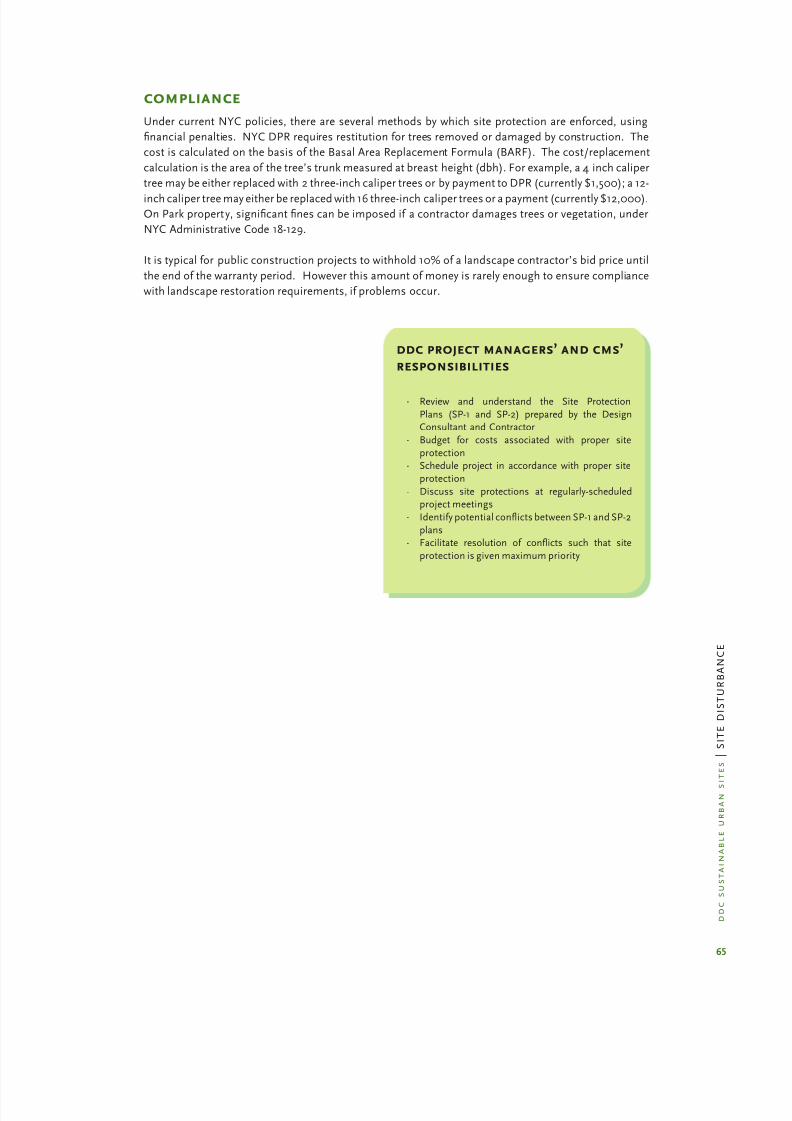
8/12/2019 Sustentable Urban Design
http://slidepdf.com/reader/full/sustentable-urban-design 72/134
65
d d c
s u s t a i n a b l e
u r b a n s
i t e s
| S I T E
D I S T U R B A N
C E
compliance
Under current NYC policies, there are several methods by which site protection are enforced, using
nancial penalties. NYC DPR requires restitution for trees removed or damaged by construction. The
cost is calculated on the basis of the Basal Area Replacement Formula (BARF). The cost/replacement
calculation is the area of the tree’s trunk measured at breast height (dbh). For example, a 4 inch caliper
tree may be either replaced with 2 three-inch caliper trees or by payment to DPR (currently $1,500); a 12-
inch caliper tree may either be replaced with 16 three-inch caliper trees or a payment (currently $12,000).On Park property, signicant nes can be imposed if a contractor damages trees or vegetation, under
NYC Administrative Code 18-129.
It is typical for public construction projects to withhold 10% of a landscape contractor’s bid price until
the end of the warranty period. However this amount of money is rarely enough to ensure compliance
with landscape restoration requirements, if problems occur.
ddc project managers’ and cms’
responsibilities
Review and understand the Site Protection·
Plans (SP-1 and SP-2) prepared by the DesignConsultant and Contractor
Budget for costs associated with proper site·
protectionSchedule project in accordance with proper site·
protection
Discuss site protections at regularly-scheduled·
project meetings
Identify potential conicts between SP-1 and SP-2·
plansFacilitate resolution of conicts such that site·
protection is given maximum priority
8/12/2019 Sustentable Urban Design
http://slidepdf.com/reader/full/sustentable-urban-design 73/134
67
d d c
s u s t a i n a b l e
u r b a n s
i t e s
| S I T E
D I S T U R B A N
C E
resources
“Urban Hydrology for Small Watersheds.” Technical Release 55, USDA, NRCS, 1986·
“Urban Soil Primer.” USDA, Natural Resources Conservation Service, 2005.·
“Wheel-induced soil physical limitations to Root Growth.” Voorhees, W. B., 1992·
New York State Stormwater Design Manual. NYS Department of Environmental Conservation,·
August 2004.New York State Standards and Specications for Erosion and Sediment Control. NYS·
Department of Environmental Conservation, February 2005.
Rules and Regulations for the Protection from Contamination, Degradation and Pollution of·
New York City Water Supply and its Sources. NYC Department of Environmental
Protection. 2002.
New York State Stormwater Management Design Manuals. NYS Department of Environmental·
Conservation www.dec.ny.gov/chemical/29072.html
New York City Reconnaissance Soil Survey. United States Department of Agriculture and the·
Natural Resources Conservation Service, 2005.
http://www.nycswcd.net/soil_survey.cfm
International Society of Arboriculture· www.isa-arbor.com
Arborcultural Specications and Standards of Practice. Oak Park, Illinois, May 2003·
“Avoiding Tree Damage During Construction,” International Societ y of Arboriculture,·
December 2004
“Construction Phase Plan Review”:·
http://cfpub.epa.gov/npdes/stormwater/menuofbmps/index.cfm
“Erosion and Sediment Control During Land Development”:·
http://www.act.gov.au/environ
“Soil Compaction-Causes and Consequences”;·
http://www.extension.umn.edu/distribution/cropsystems/
components.html
“Construction Site Management”:·
http://www.epa.gov/nps/MMGI/Chapter4/ch4-3a.html
Managing Soil Compaction·
http :www.ext.colostate.edu/PUBS/crops/00519.htmlSanta Monica Green Building Program : Inventory, Mark & Protect Topsoil·
http://greenbuildings.santa-monica.org/construction/topsoiltree.htm
“Caring for the Land.” Bruce Hendler, 1977·
http://planning.org/APAStore/Search/Default.aspx?p=2261

8/12/2019 Sustentable Urban Design
http://slidepdf.com/reader/full/sustentable-urban-design 74/134
68
d d c
s u s t a i n a b l e
u r b a n s i t
e s
| S I T E
D I S T U R B A N
C E
understanding soils
Soil is the interface between the earth’s atmosphere and bedrock or ground water. It has either
formed in place or has been transported to its present location by wind, water, ice, gravity, or
humans. There are more than 22,000 different soils identied in the United States. Eighty-seven
soil types have been identied in NYC thus far; as of 2005, soil mapping is based on sites of 40 acres
or larger. While this information offers a general understanding of a project’s geologic context,
site specic soil tests are required. Designers can best predict how soils will react to different uses
by understanding soil properties, such as soil texture and structure, particle-size distribution, soil
reaction, and bulk density. This understanding enables projects to minimize maintenance costs,
prevent harm to people and ecosystems, and be durable over time. Well structured soils sustain
biological activity, diversity, and productivity, regulate water and solute ow, lter and immobilize
noxious materials, and provide support for structures. Construction activities, compaction, and
surface sealing dramatically change soil properties and can result in a reduced ability to perform the
critical functions or activities of natural soil.
Urban soils can be divided into two types: natural soils, which formed in material naturally deposited,
and anthropogenic soils, which formed by in human-deposited material or ll. New York City’s
complex geology includes layers of crystalline bedrock, sedimentary rock, coastal plain sediments,
and glacial deposits, which are classied as natural material. Urban soil characteristics depend
on the following: a) how deep the site excavation has been/will be; b) if imported ll was/will be
mixed with original soil materials; and c) the properties of the original soil or prior uses of the site.
Changing the order of the soil layers alters soil properties.
All soil is made up of mineral matter (clay, silt, sand), organic matter (living or dead organisms), air,
and water. In the urban arena, it may also include manmade materials such as construction debris,
dredge ll, coal ash, and municipal solid waste. Soils are made up of horizons or layers that result
from soil-forming factors. In an undisturbed area, there are 6 major horizons that form the soil
prole and include the uppermost layers of largely organic matter, subsoils (largely mineral matter)
in the middle range, and bedrock at the lowest level. In nature, soils are altered by topography andmicroclimate as well as decomposition of organisms. Urban soils differ from natural soils because
they have been altered to some degree through lling and construction. Construction typically
disrupts the natural soil prole by removing topsoil or mixing topsoil with subsoils, importing
foreign soils for ll or growing medium, altering natural drainage patterns, and creating compacted
soil layers that can result in a perched water table. This is an impenetrable hard pan layer that
prevents downward water movement and lls the root zone with too much water or s prevents water
from reaching plant roots. A perched water table can also be very damaging to surfaces as trapped,
shallow water will freeze and heave pavements.
Physical soil properties: Sand, silt and clay are dened on the basis of the size of each individual
soil particle’ the composition of the three determines the soil texture. Soil texture affects water and
air movement through the soil, as particles of dif ferent sizes pack together and thus determine thesize and spacing of pores and channels. Soil structure is the combination of these primary soil
particles into secondary units or aggregates. Organic materials and clay are important binding
agents. When soil is dry, the pores are mainly lled with air; when soils are wet, the pores are
mainly lled with water. A “textbook” soil is comprised of 45 percent mineral, 25 percent air, 25
percent water, and 5 percent organic matter. The mixture of particle sizes affects water, nutrient,
and contaminant absorption. Sand particles have the largest pore spaces and allow water to drain
most freely. Clay particles have very small pores, so they tend to absorb and hold more water.
Chemical soil properties: Soils supply air, water, nutrients and living space for micro-organisms,

8/12/2019 Sustentable Urban Design
http://slidepdf.com/reader/full/sustentable-urban-design 75/134
69
d d c
s u s t a i n a b l e
u r b a n s
i t e s
| S I T E
D I S T U R B A N
C E
plants, animals, and humans. The ability of soil particles to hold and release nutrients is called
the cation-exchange capacity (CAC). Cations in the soil are positively charged nutrients such as
nitrogen, sodium, calcium, and potassium as well as trace metals. Soil acidity, as measured by pH
(scale 1-14), is the common measure of soil reaction. The lower the number, the greater the acidity.
The midpoint of the pH scale is neutral (7.0), a good level for the growth of most plants. At higher
pH levels (8.5+), metals are sequestered in the soil; at lower levels, metals are released and becomeavailable for ingestion by plants and animals. Most urban soils have a pH level higher than 7.0 due
to the presence of alkaline waste materials (concrete, masonry, construction debris).
Biological soil properties: Soil organic matter is the thread that links chemical, physical and biological
properties of soil. It is able to supply micronutrients to plants, to stabilize soil particles together as
aggregates, to resist compaction, to promote water inltration and to reduce negative environmental
effects of pesticides, heavy metals and other pollutants by binding contaminants. Organic matter is
comprised of decomposed animals and plants. In a healthy environment, the process is on-going,
with new material continuously introduced and decomposed. In an urban environment, there may
not be sufcient plant, insect, and microbial activity to replenish organic matter.
Water Movement: Water movement in urban soils includes
inltration, percolation and permeability. Inltration rate is the
velocity at which water can seep into the ground. A low inltration
rate is less than 6 inches per hour; a high inltration rate is 2
inches per hour. Percolation is the movement of water downward
and radially through subsurface soil layers to groundwater or a
zone of saturation. This is also measured in inches per hour.
Permeability describes the ease with which gases, liquids, or
plant roots penetrate a bulk mass of soil. Soils are categorized by
classes of permeability based on a vertical velocity prole ranging
from very rapid to impermeable. The movement of water into
and through soil depends on soil texture, soil structure, slope,
bulk density, compaction, surface loading, and vegetation. In
urban areas with large amounts of impervious or compacted
surfaces, much of the water evaporates into the air or runs off
into sewers and water bodies. As urban water runs off, it carries
with it contaminants, sediments or soil particles that pollute the waterways.. Due to the urban heat
island effect, water running off impervious surfaces introduces
warm water into natural systems that alters the balance among
microbial and aquatic habitats.
Bulk Density: Bulk density is the weight of soil solids per
unit volume of soil. Bulk density is an important measure of
compaction; a soil compacted by construction equipment willdisplay a bulk density 150% greater than an open, friable soil. Bulk
density is also a measure of organic content as organics are lighter
than mineral content.
Infiltration
Zone
Percolation
Zone
Permeability
Zone
Comparison of descriptive terms for water movement insoils
Air
Air or water
Water
Mineral matter
(rocks, sand,
silt, clay)
Organic matter
Solids Pore space

8/12/2019 Sustentable Urban Design
http://slidepdf.com/reader/full/sustentable-urban-design 76/134
70
d d c
s u s t a i n a b l e
u r b a n s i t
e s
| S I T E
D I S T U R B A N
C E
sample details
c
-
SEIJJQti
lQJLNO MATERIAL OR EQUIPMENT SKALL BE
STORED OR STOCKPILED WITHIN THE
AREA SURROUNDED BY TREE
PROTECTION FENCING.
L LIGN FENCE WITH
DRIPLINE OF TREE
I.f
(RPZ MINIMUM DISTANCE)
EXISTING TREE
2" X 4 POST, TYP.
4 4 POST, TYP.
1-1/2 OC WDNO MESH
HIGH DENSITY POLYETHYLENE
FENCE (OPANGE)
VARIES
EL&
D STREET TREE PROTECTION , TYPENOT TO SCALE
NOTES:
LOCATE FENCING AS SHOWN ON PWJS.
NO MATER14L OR EQUIPMENT SHALL BE STORED
OR STOCKPILED WITHIN THE AREA SURROUNDED
BY TREE PROTECTION FENCING,
EXISTING TREES TO REMAIN
~ ~ 1 7 ~ 1-1/2' OIMjONO MESH HIGH OENSITY
POLYETHYLENE FENCE (ORN1GE),
MIN. DRIP LINE
EXTENT
MIN ORIP LINE5' D.C., MAX. EXTENT
D STREET TREE PROTECTIONNOT TO SCALE
WIRE
1-3/4 x 1", 13 GA. U CHANNEL STEEL
POSTS w CLIPS 6" D.C. VERT., TYP.
MESH GU RD

8/12/2019 Sustentable Urban Design
http://slidepdf.com/reader/full/sustentable-urban-design 77/134
71
d d c
s u s t a i n a b l e
u r b a n s
i t e s
| S I T E
D I S T U R B A N
C E
sample details
NOTE:
NO MATERlAl OR EQUIPMENT SHALL BE
STORED OR STOCKPILED WITHIN THEAREA SURROUNDED BY TREE
PROTECTION FENCING.
ALIGN FENCE WITH
DRIPLINE OF TREE
VARIES
1------- ---- EXISTING TREE ------ -----.:>
1-3/4 x 13 GA. U
CH.AJljNEL STEEL POSTS W/
CLIPS 6 D.C. VERT., TYP.
D TREE PROTECTION
NOT TO SCALE
NOTE
INSTALL SLOPE STABILIZATION BLANKETS IN ALL AREAS WHERE SLO PE EXCEEDS 4:1 SLOPE, PRIOR TO
FiNAl PWHlNG.CONTRACTOR
SHAlLBE RESPONSIBLE FOR MAINTAINING SLOPE STABILIZATIONBWJKET UNTIL VEGETATED AREA IS FULLY ESTABLISHED.
SLOPE STABILIZATION ~ K E T
8 L WIRE STAPLES 24 O.C.
FINISH GRADE
F R ~ E TOP SOIL
NEW OR AMENDED EXISTING)
~ ~ S ~ L ~ O ~ P ~ E ~ S ~ T ~ ~ B ~ I L ~ I Z ~ ~ T ~ I O ~ N ~ __________________________V NOT TO SCAlE

8/12/2019 Sustentable Urban Design
http://slidepdf.com/reader/full/sustentable-urban-design 78/134
72
d d c
s u s t a i n a b l e
u r b a n s i t
e s
| S I T E
D I S T U R B A N
C E
Silt Fence
sample details

8/12/2019 Sustentable Urban Design
http://slidepdf.com/reader/full/sustentable-urban-design 79/134
73
d d c
s u s t a i n a b l e
u r b a n s
i t e s
| S I T E
D I S T U R B A N
C E
sample details
i::
TWER [ N D ~ ~ L ~ ~ i G A T [ ~1-111-111=111=111 1=11-D
~ - I I I - ' ~ ~CROSS S E T I ~ E X I S T I N G GRADE
,
6
12 MIN, E X I S T I ~ G SIDEWAlK OR
' 'P Q I ~ T OF EGRESS
\
\AGGREGATE
R m
f 7 r C ~ O ~ N _ S ~ T ~ R _ U ~ C ~ T ~ I O ~ N ~ D ~ R ~ I V ~ E ~ W ~ A ~ Y ~ E ~ N ~ T ~ R ~ A ~ N ~ C = E ___V NOT TO SCALE
Applicable to new trees in a row

8/12/2019 Sustentable Urban Design
http://slidepdf.com/reader/full/sustentable-urban-design 80/134
water
management on
urban sites
p h o t o : N Y C D e p a r t m e n t o f D e s i g n a n d C o n s t r u c t i o n

8/12/2019 Sustentable Urban Design
http://slidepdf.com/reader/full/sustentable-urban-design 81/134
75
d d c s u s t a i n a b l e u r b a n
s i t e s
| W A T E R
Precipitation amounts have increased in themid and high latitudes, often in excess of 10%
since the turn of the {20th} century. This
is especially important because once soilsbecome saturated, seemingly small increases
in rainfall can cause large increases in runoff,
resulting in fl oods.
“Global Warming and the Earth’s WaterCycles” US Global Change Research
Program, October 12, 2003
WATER MANAGEMENT ON URBAN SITES
Water management in NYC site and landscape architectural design must respond to two fluctuating
conditions – too much and too little rainfall – with techniques to control the on-site water, namely:
Stormwater Management· : Controlling the water from typical and unusual storms so that it
does not damage the vegetation and soils, or does not flood streets and adjacent properties, nor
overwhelm the City’s combined and separate sewer system.
Water-ef ficient Landscaping:· Conserving potable water while maintaining healthy plants and
an attractive landscape.
This chapter examines the underlying issues of both aspects of water management, and suggest some
design and construction techniques to control and conserve water.
stormwater management
Stormwater runoff occurs when precipitation from rain or snowmelt flows over the ground. Impervious
surfaces such as driveways, parking lots, sidewalks and streets prevent stormwater runoff from naturally
soaking into the ground. Traditionally, the aim of a stormwater management system has been to collect,
conduct and dispose of stormwater as ef ficiently and as quickly as possible. Instead of infiltrating water
to the ground, these hard surfaces direct stormwater into the nearest storm drain or combined sewer
system. They are so ef ficient at moving water that the time for stormwater to arrive at any given point in
the watershed is very short, translating into large volumes of runoff occurring in a short amount of time.
This method of stormwater management can result in serious environmental degradation.
Stormwater can pick up debris, chemicals, dirt, and other pollutants, which can then flow directly into a
storm sewer system, lake, stream, river, wetland, or coastal water body. This polluted stormwater runoff
can have many adverse effects on plants, fish, animals and people. For example:
Sediment can cloud the water, reducing oxygen and the penetration of sunlight, and destroy·
aquatic habitats;
Excess nutrients in sediments cause algal blooms that also result in drastic reduction of dissolved·
oxygen in the water and thereby suffocate fish and other aquatic organisms;
Bacteria and other pathogens wash into swimming areas, requiring beaches to close;·
Debris that is washed into water bodies can choke or disable fish and aquatic birds;·
Hazardous wastes such as pesticides, paints and solvents poison aquatic life, and cause people·
and land animals to become sick from either ingesting the contaminated water or fish in whose
fat these contaminants accumulate.
New York City stormwater can cause additional pollution of a different
kind, since NYC has a combined sewer system in many areas, which
means that the same sewer lines that carry sanitary sewage also collect the
storm runoff. Intense storms can flood this system with more than NYC’s
sewage treatment plants can handle. The result is a Combined Sewer
Overflow event (CSO), in which the overflow of untreated stormwaterand septic sewage is discharged directly into natural water bodies.
Studies show that untreated urban stormwater runoff generated during
the first hour of intense storm events – referred to as the “first flush” –
can have even greater pollutant concentrations than raw sewage. During
wet weather events, large quantities of untreated sewage and stormwater
contaminated with surface pollutants discharge into the New York Harbor
by way of more than 494 combined sewer outfalls.1
1 “Water Ef ficient Landscaping: Preventing Pollution & Using Resources Wisely”
www.epa.gov/watersense/docs/water-ef ficient_landscaping_508.pdf

8/12/2019 Sustentable Urban Design
http://slidepdf.com/reader/full/sustentable-urban-design 82/134
76
d d c s u s t a i n a b l e u r b a n
s i t e s
| W A T E R
Landscape design strategies can slow down the flow of water across the site, absorb it and cleanse it.
Designers have creative opportunities to express the processes of water collection, retention, filtration
and release of stormwater that can be as educational and attractive as they are instrumental to
improving the urban environment.
water-efficient landscaping
Just 1% of the entire water supply in the world is available for human use; the rest is salty or locked inice caps and glaciers. NYC Department of Environmental Protect ion has a target goal to reduce water
consumption in the City by 5% over the next several years and NYC Local Law 86 seeks to reduce water
consumption in new public buildings by as much as 30%. According to the U.S. Geological Survey, of
the 26 million gallons of water consumed daily in the United States, approximately 7.8 billion gallons,
or 30%, is devoted to outdoor uses. The majority of this is used for landscaping.1 Rethinking how
landscapes are designed can save significant quantities of water and engender the following benefits:
Significantly reduce demand for irrigation(potable) water, by using native and other “climate·
appropriate” landscape materials;
Decrease energy use and air pollution because less pumping and treatment of water is required;·
Save water as well as time and money spent mowing, fertilizing, removing green waste and·
maintaining landscapes, by limiting the use of turf and other irrigation-requiring vegetation;Reduce runoff of stormwater and irrigation water that carry sediments, fertilizers and pesticides·
into receiving water bodies;
Encourage plants to develop a self-sustaining root system capable of withstanding moisture·
fluctuations, by not watering in excess of a plant’s essential need.
laws, rules and regulations
summary – laws, rules and regulations
See text and web links below for more information. Refer to chapter: Minimize Site Disturbance for
Laws, Rules and Regulations pertaining to runoff from construction sites. Not included are regulations
pertaining to private sewers and private pumping stations. This is a summary of key regulations, not
necessarily all that may apply.
agency law, rules, and regulations 2008 applicability
US Environmental ProtectionAgency (USEPA)
Section 401 Permit;Section 301, 302, 303, 306, 307
certifications
Fresh and tidal wetlands; seweroutfall construction; ef fluent
limitations for point source
discharges etc.
NYS Department of
Environmental Conservation
(DEC)
No Exposure Certification Form
Industrial activities and materials
must be protected by a storm
resistant shelter to prevent
exposure to runoff
SPDES Multi-Sector General Permit
GP-0-06-002
Permit required for stormwater
discharge associated with
industrial activity
Tidal wetlands permit Construction of or disposal into a
sewer outfall
Tidal wetlands permit Restriction on activities allowed in
and adjacent to a wetland (150 feet
landward)

8/12/2019 Sustentable Urban Design
http://slidepdf.com/reader/full/sustentable-urban-design 83/134
8/12/2019 Sustentable Urban Design
http://slidepdf.com/reader/full/sustentable-urban-design 84/134
78
d d c s u s t a i n a b l e u r b a n
s i t e s
| W A T E R
Web links – Note that full regulations not always available on-line.
US Army Corps of Engineers www.usace.army.mil/inet/functions/cw/cecwo/reg/
NYS Department of Environmental Conservation www.dec.state.ny.us/website/dow/mainpage.ht
New York State Stormwater Design Manual
NYC Department of Environmental Protection www.ci.nyc.us/html/dep/watershed/html/regulations.html
NYC Department of City Planning
Waterfront Revitalization Program www.ci.nyc.ny.us/html/dcp/html/wrpSpecial Natural Area District www.nyc.gov/html/dcp/html/snad/index.shtml
Street Tree Text Amendment www.ci.nyc.ny.us/html/dcp/pdf/street_tree_planting/proposed_text.pdf
NYC Of fice of Environmental Coordination www.nyc.gov/html/oec
leed and water managementWith the enactment of Local Law 86 of 2005 (effective January 1, 2007), the City now requires most of
its projects to meet the Silver level of the LEED certification process of the U.S. Green Building Council
(USGBC). Water management has two aspects that relate to LEED credits – stormwater management and
water ef ficient landscaping.
Stormwater management credit SS 6.1 is aimed at
controlling the quantity of stormwater runoff, and maybe achieved by minimizing impervious surfaces and
increasing on-site infiltration. The companion credit SS
6.2 is aimed at reducing water pollution by increasing
infiltration and controlling the quality of any stormwater
runoff. Natural and structured treatment systems are
discussed in this chapter. Stormwater management also
contributes to the SS Pre-requisite, Construction Activity
Pollution.
To achieve the Water Ef ficiency credits WE 1.1 and WE
1.2, an ef ficient irrigation system must be used, or no
irrigation system at all. One year of irrigation is allowed
for initial plant establishment . Using grey water forirrigation will also achieve this point, as well as contribute
the credit WE 2 for Innovative Wastewater Technologies,
and WE 3 for Water Use Reduction.
stormwater management - key issuesWhen water, soil and vegetation are purposely introduced into a site, four beneficial functions result:
water is soaked into the soil and absorbed by vegetation; water is cleansed as it flows over and through
vegetation and soil; water is transpired by vegetation; and precipitation is intercepted by vegetation. The
combination of these functions reduces combined sewer overflows (CSO) events, lowers temperature of
runoff reaching streams, wetlands and water bodies, recharges groundwater and greatly reduces pollutant
levels conveyed by storm sewers to surrounding water bodies.
The planning and design objectives for stormwater management should be to:
Reduce· runoff quantity by using infiltration strategies that lessen the amount of water entering,
and therefore discharging, into receiving waters;
Detain· stormwater runoff temporarily to reduce peak runoff rates to the sewer system and
pollution control plants;
Treat· stormwater runoff to reduce constituents that cause water pollution.
LEED creditsWater Management can contribute to the following
LEED credits:
Sustainable Sites:Credit SS Pre-requisite 1 – Construction Activity
Pollution Prevention
Credit SS 6.1 – Stormwater Management – Quantity
ControlCredit SS 6.2 – Stormwater Management – Quality
Control
Water Ef ficiency:Credit WE 1.1 Water Ef ficient Landscaping – Reduce
by 50%
Credit WE 1.2 Water Ef ficient Landscaping – Nopotable water or No irrigation
Credit WE 2 Innovative Wastewater Technologies
8/12/2019 Sustentable Urban Design
http://slidepdf.com/reader/full/sustentable-urban-design 85/134
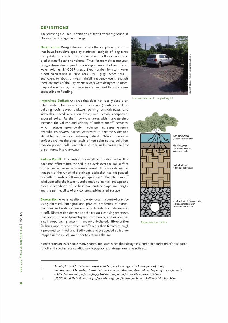
8/12/2019 Sustentable Urban Design
http://slidepdf.com/reader/full/sustentable-urban-design 86/134
80
d d c s u s t a i n a b l e u r b a n
s i t e s
| W A T E R
definitions
The following are useful definitions of terms frequently found in
stormwater management design:
Design storm: Design storms are hypothetical planning storms
that have been developed by statistical analysis of long term
precipitation records. They are used in runoff calculations topredict runoff peak and volume. Thus, for example, a 100-year
design storm should produce a 100-year amount of runoff and
water volume. NYCDEP uses a fixed number for stormwater
runoff calculations in New York City – 5.95 inches/hour –
equivalent to about a 5-year rainfall frequency event, though
there are areas of the City where sewers were designed to more
frequent events (1,2, and 3-year intensities) and thus are more
susceptible to flooding.
Impervious Surface: Any area that does not readily absorb or
retain water. Impervious (or impermeable) surfaces include
building roofs, paved roadways, parking lots, driveways, and
sidewalks, paved recreation areas, and heavily compacted,exposed soils. As the impervious areas within a watershed
increase, the volume and velocity of surface runoff increases,
which reduces groundwater recharge, increases erosion,
overwhelms sewers, causes waterways to become wider and
straighter, and reduces waterway habitat. While impervious
surfaces are not the direct basis of non-point source pollution,
they do prevent pollution cycling in soils and increase the flow
of pollutants into waterways. 3
Surface Runoff: The portion of rainfall or irrigation water that
does not infiltrate into the soil, but travels over the soil surface
to the nearest sewer or stream channel. It is also defi
ned asthat part of the runoff of a drainage basin that has not passed
beneath the surface following precipitation.4 The rate of runoff
is influenced by the intensit y and duration of rainfall, the type and
moisture condition of the base soil, surface slope and length,
and the permeability of any constructed/installed surface
Bioretention: A water quality and water quantity control practice
using chemical, biological and physical properties of plants,
microbes and soils for removal of pollutants from stormwater
runoff. Bioretention depends on the natural cleansing processes
that occur in the soil/mulch/plant community, and establishes
a self-perpetuating system if properly designed. Bioretention
facilities capture stormwater runoff that is thenfiltered througha prepared soil medium. Sediments and suspended solids are
trapped in the mulch layer prior to entering the soil.
Bioretention areas can take many shapes and sizes since their design is a combined function of anticipated
runoff and specific site conditions – topography, drainage area, site soils etc.
Porous pavement in a parking lot
p h o t o : M a t h e w s N i e l s e n L a n d s c a p e A r c h i t e c
t s
Ponding Area(captures stormwater)
Mulch Layer(traps sediments and
suspended soils)
Soil Medium(filters out pollutants)
Underdrain & Gravel Filter(optional: most useful in
shallow or dense soil)
Biorentention profile
3 Arnold, C. and C. Gibbons. Impervious Surface Coverage: The Emergence of a KeyEnvironmental Indicator. Journal of the American Planning Association, 62(2), pp.243-256, 1996
< http://www.nyc.gov/html/dep/html/harbor_water/wwwsystemprocess.shtml>4 USGS Flood De finitions: http://ks.water.usgs.gov/Kansas/waterwatch/ fl ood/de finition.html

8/12/2019 Sustentable Urban Design
http://slidepdf.com/reader/full/sustentable-urban-design 87/134
81
d d c s u s t a i n a b l e u r b a n
s i t e s
| W A T E R
Absorption: The action of water movement into the spaces between soil particles and then is taken up by
plant roots.
Filtration: Practices that capture and temporarily store runoff, and strain out undesirable particles using
various media. Filtration media include sand beds, organic matter, geotextile fabrics, soil or other
acceptable treatment materials.
Infiltration: The downward migration of runoff through the planting soil and into surrounding soils.
Infiltration practices capture and temporarily store the runoff before allowing it to infiltrate into
the soil.
techniques for managing stormwater
summary - key techniquesSee text for more detail.
stormwater techniques appropriate applications Resources
Hardscape Techniques
Pervious Paving Parking lots, plazas, pedestrian paths, overflow parking areas,
paved play fields, bike pathsDiagram/Details
Pre-Treatment Techniques
Filtration Basin/Sand Filter Fueling areas, truck washing areas, outdoor storage areas
containing products that could contaminate soilDiagram
Vegetative Filter/Buffer Parking lot islands, perimeter landscaped areas adjacent to
paved areasDiagram
Bark Beds Parking lot islands, perimeter landscaped areas adjacent to paved
areas–
Catch Basin Inserts Loading docks, fueling areas –
StructuralTechniques
Planters Entry plazas, elevation changes adjacent to steps or ramps Diagram
Storage/Infiltration Beds Under paved or planted areas where soil has good percolation –
Water Quality Inlets Parking lots, loading docks – Drywells Under paved or planted areas where soil has good percolation –
Subsurface DetentionTanks
Where soil has poor percolation and where sewer capacity is limited –
Rooftop Detention Green and Blue Roofs
Where structural capacity, roof slope and waterproofing systempermit
Photo
Rain Barrels/ Cisterns For low volume rainwater collection Photo
Bioengineered Techniques
Infiltration Areas Landscaped area, courtyards, plazas, parking lot islands Diagram
Tree Pit Enhancement Sidewalks, plazas, courtyards –
Infil tration Swale Parking lots, road edges, narrow landscaped areas where soil hasgood percolation
Diagram

8/12/2019 Sustentable Urban Design
http://slidepdf.com/reader/full/sustentable-urban-design 88/134
82
d d c s u s t a i n a b l e u r b a n
s i t e s
| W A T E R
Rain Garden/Bioretention
Small landscaped areas under downspouts or impervious
surfaces
Diagram
Underdrained
Bioretention
Plazas, parking areas or roads where soils exhibit poor
percolation
Diagram
Recharge Basin Plazas, parking areas or roads when site is located over an
aquifer
–
Slope Reduction Bench Large to medium-sized sloping vegetated area Diagram
Shoreline Restoration Any site adjacent to a freshwater or intertidal wetland, fresh,
brackish or salt water body
–
Plant Material/Design Any application of vegetation used for bioengineered
stormwater management
Plant list
Vegetated Roof Any flat or gently sloping roof with adequate structural
capacity (see DDC Cool and Green Roo fing Manual )
–
Berms Medium to large sites whose construction will generate
excess soil
–
Initial planning and design decisions need to identify the goals of its stormwater management program.
This includes determining the amount of runoff that will be allowed to leave the site pursuant to DEP
regulations, LEED™ goals, etc, and the manner in which runoff will be reduced, treated, and detained.
These decisions need to be made in conjunction with local and site-specific data, including topography,
drainage basins, existing size and type of sewers, and soil characteristics. Knowledge of these factors helps
determine appropriate stormwater management measures. (see also “Soil Testing Requirements” later in
this chapter).
At a minimum, the design should not increase the volume of runoff leaving the site, compared to the pre-
existing condition. Even better is to achieve “zero runoff” wherein all stormwater is captured, detained
and absorbed on site. A “treatment train” of stormwater techniques utilizes a variety of methods to create
synergy among natural systems, as well as providing a back-up for extreme storm events. Specifically, these
techniques for stormwater management are grouped into four categories of strategies:
Hardscape Techniques: Design decisions that reduce runoff. Minimize the amount of impervious
surface to only what is required by the program; Limit the use of turf grass and create “absorbent
landscapes.” Refer to the chapter: Maximize Vegetation.
Pretreatment Techniques: Techniques that provide initial treatment and reduce the velocity of stormwater
before it enters a downstream conveyance or outlet. Use vegetated filter and buffer strips to remove large
sediments, debris and chemicals from stormwater before it enters downstream systems; Use catch basin
inserts to remove floatables from entering systems; Use specific drainage structures that help improve
water quality - such as oil and grit separators - to remove sediments and hydrocarbons before they pollute
waterways.
Structural Techniques: Techniques that use physical means to control and treat runoff; useful inconditions where bioengineered solutions cannot work.Use detention structures to slow the velocity of
runoff and temporarily and store it during peak flow periods; Use infiltration structures (both surface and
underground) to reduce peak flows, improve water quality and promote groundwater recharge.
Bioengineered Techniques: Systems that mimic natural hydrology and ecology, and rely on natural
processes to reduce and treat runoff. Employ bioretention techniques that may be used to direct runoff into
the municipal storm sewer, to infiltrate runoff or to provide a combination of conveyance and infiltration;
Create constructed wetlands, or permanent non-stagnant pools of water, planted with appropriate
associations of vegetation (aquatics, emergents), that are designed to reduce, detain and treat stormwater
runoff; Design natural or naturalized edges at the interface between the upland and the shoreline of rivers,
lakes or estuaries.

8/12/2019 Sustentable Urban Design
http://slidepdf.com/reader/full/sustentable-urban-design 89/134
83
d d c s u s t a i n a b l e u r b a n
s i t e s
| W A T E R
hardscape techniquesOne of the basic considerations in limiting the generation of runoff is the permeability of the site – the
ability of the site to absorb the stormwater before it becomes runoff. Refer to the Minimize Site Disturbance
chapter for a discussion of appropriate soil and subsurface geologic conditions that are suitable for these
applications. Creating and conserving planted areas is one technique, as is limiting the amount of paved
area. For those areas that must be paved, there are systems that allow water to penetrate and be absorbed
into the soil. These include porous paving and permeable paving systems.
porous pavements
These are asphalt or concrete pavements in which the fines – the smaller particles in the mix of aggregate
materials comprising them – have been held to a minimum to allow stormwater to pass through the
pavement. Beneath the porous layer of pavement is a uniformly graded bed of clean stone with a minimum
void space of 40%, lain in suf ficient depth to catch and store a calculated volume of stormwater as it drains
through it. The bottom of the stone bed is underlain with filter fabric to allow water to then infiltrate into
the native soil, and to prevent soil from migrating upward into the voids of the stone base. When planning
areas to be paved with permeable pavements, it is important to note that the permeability of underlying
soil subgrades are usually less than the surface infiltration rates, so it is good practice to design the base
layer to be able to store 100% of the stormwater volume anticipated to infiltrate the area. It is often
necessary to include an overflow control structure (underdrain pipe) so that during large storm events,
water will not rise to the pavement level.
Porous pavements are effective for
pedestrian pavements, plazas or parking
areas. The lifetime of all porous pavements
can be extended by pre-treating runoff. Filter
strips or small basins that trap sediments and
debris are very ef fective in reducing clogging
of void space. Refer to filtration techniques
later in this section.
These porous pavements have somesignificant limitations:
· Not recommended for slopes greater
than 5%;
· Subsoil must have a minimum infiltration
rate of 6 to 8 inches per hour, or outlet
pipes may be required;
· Minimum depth to bedrock or
groundwater should be 3 feet;
· Requires periodic “vacuuming” or power washing to remove fine materials such as mud,
sediment, cinders from snow plowing, etc., from clogging void spaces;
· Porous pavements are not permitted for use in the Right-of-Way according to NYC Department of
Transportation.
Porous Concrete Pavements: Porous concrete is a structural, open textured paving surface consisting
of standard Portland cement, fly ash, locally available open graded coarse aggregate, admixtures, fibers
and potable water. When properly mixed and installed, porous concrete has a 17%-22% void space which
allows rapid percolation of stormwater. The characteristic of porosity does not limit these pavements in
terms of durability or load bearing capacity. Porous concrete is about 85% the strength of conventional
concrete; they are good for sidewalks, driveways, alleys, parking lots and plazas.
Porous Asphalt Pavements: Porous asphalt paving consists of an open graded coarse aggregate bound
together by asphalt cement with suf ficient interconnected voids to provide a high rate of permeability.
C a l c u l a t e d W a t e r
S t o r a g e
Concrete Curb
Reservoir Base Course
Pervious Concrete Paving
Porous concrete pavement
Porous Asphalt Surface Course
1/2” to 3/4” Aggregate Asphalt Mix
Filter Course1/2 Aggregate, 2” Thickness
Reservoir Base Course
1” to 2” Aggregate
Voids volume is designed for r unoff retention.
Thickness is based on storage required.
Filter Fabric
Porous asphalt pavement

8/12/2019 Sustentable Urban Design
http://slidepdf.com/reader/full/sustentable-urban-design 90/134
84
d d c s u s t a i n a b l e u r b a n
s i t e s
| W A T E R
permeable pavers
These are modular pavers that contain voids, or create voids in the paved surface that allow the penetration
of water. There are 4 categories of porous pavers:
Interlocking Concrete Blocks: These are precast units capable of withstanding AASHTO H-20 (80 psi)
loading and may be laid on compacted subgrade or aggregate base with a sand setting bed. The voids
between the blocks may be filled with topsoil and grass seed or filled with crushed gravel, sand, or tumbledglass. This system is ideally suited to light use parking areas,fire lanes and tree trenches. When filled with
either turf or gravel, the concrete hubs are visible so the appearance is mottled rather than uniform. The
units can also be used to stabilize embankments along water courses.
Cast-in-Place Concrete Blocks: These are made with
reusable forms and create voids for planting. An advantage
of the cast in place system over interlocking concrete blocks
is its resistance to differential settlement and frost heave.
Residual surface water, or runoff, is held within formed
soil pockets thereby controlling the rate of infiltration. As
with the interlocking concrete block system, if turf is the
selected void infill system, this material is best used on
roads and paths that are not traversed on a daily basis.
Flexible Plastic Cellular Confinement Systems: These
modular systems used to be known as “reinforced turf
systems” before their stormwater advantages became
known. The system acts as a load-bearing surface that
protects herbaceous vegetation from compaction. High
void spaces within the cross section foster good root development, storage capacity for rainfall and
runoff cleansing as water moves through the sand/gravel layers. Plant roots help to further breakdown
suspended pollutants, particularly hydrocarbons. These systems appear as a uniform surface of grass.
A variation on this system is one in which the voids are filled with gravel. Depending on the choice and
depth of gravel, these systems can store significant amounts of runoff. Gravel-filled systems have none
of the maintenance issues of the turf-filled systems. Both turf and gravel systems are easy to walk on
and are suitable for all forms of vehicular and pedestrian applications.
Modular, Molded Plastic Materials: Similar to the flexible cellular confinement systems, the difference
being in the manufacturing process. Void in the units may befilled with turf or gravel.
All installations of porous modular pavement should be designed and constructed according to the
manufacturer’s specifications. Pavements using vegetative infill must be capable of disposing stored
water within 24-36 hours to avoid damage to the herbaceous plants. Parking areas should avoid extensive
ponding for periods exceeding an hour or two. Other facilities should evaluate the acceptable time limit
for infiltration based on performance criteria and function. As with other porous pavements, subsoil
infiltration rate will directly affect the success of porous pavers.
maintenance precautions
With most porous pavers, it is important to remove any deeply-rooted woody plants that may colonize the
surface, since they can disrupt the paving and reduce its permeability. Also, snow plow operations must
be done carefully since differential settlement may cause “lipping” of the pavers, and if the plow blades or
loader buckets are set too close to the surface, they can damage or dislodge the pavers. Maintenance is
also required on a routine basis to remove sediments that may void spaces in porous pavements.
p h o t o : M a t h e w s N i e l s e n L a
n d s c a p e A r c h i t e c t s
Grass filled and concrete pavers
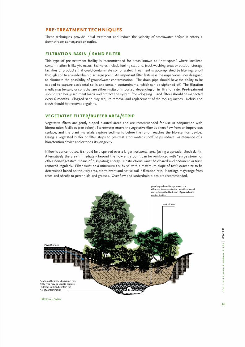
8/12/2019 Sustentable Urban Design
http://slidepdf.com/reader/full/sustentable-urban-design 91/134
85
d d c s u s t a i n a b l e u r b a n
s i t e s
| W A T E R
pre-treatment techniquesThese techniques provide initial treatment and reduce the velocity of stormwater before it enters a
downstream conveyance or outlet.
filtration basin / sand filter
This type of pre-treatment facility is recommended for areas known as “hot spots” where localizedcontamination is likely to occur. Examples include fueling stations, truck washing areas or outdoor storage
facilities of products that could contaminate soil or water. Treatment is accomplished byfiltering runoff
through soil to an underdrain discharge point. An important filter feature is the impervious liner designed
to eliminate the possibility of groundwater contamination. The drain pipe should have the ability to be
capped to capture accidental spills and contain contaminants, which can be siphoned off. The filtration
media may be sand or soils that are either in situ or imported, depending on infiltration rate. Pre-treatment
should trap heavy sediment loads and protect the system from clogging. Sand filters should be inspected
every 6 months. Clogged sand may require removal and replacement of the top 2-3 inches. Debris and
trash should be removed regularly.
vegetative filter/buffer area/strip
Vegetative filters are gently sloped planted areas and are recommended for use in conjunction with
bioretention facilities (see below). Stormwater enters the vegetativefilter as sheet flow from an impervious
surface, and the plant materials capture sediments before the runoff reaches the bioretention device.
Using a vegetated buffer or filter strips to pre-treat stormwater runoff helps reduce maintenance of a
bioretention device and extends its longevity.
If flow is concentrated, it should be dispersed over a larger horizontal area (using a spreader check dam).
Alternatively the area immediately beyond the flow entry point can be reinforced with “surge stone” or
other non-vegetative means of dissipating energy. Obstructions must be cleared and sediment or trash
removed regularly. Filter must be a minimum 20’ by 10’ with a maximum slope of 10%; exact size to be
determined based on tributary area, storm event and native soil infiltration rate. Plantings may range from
trees and shrubs to perennials and grasses. Overflow and underdrain pipes are recommended.
Paved Surface
planting soil medium prevents the
effluents from penetrating into the ground
and reduces the likelihood of groundwater
contamination
Mulch Layer
capping the underdrain pipe, this
ility type may be used to capture
cidental spills and contain the
el of contamination
Filtration basin

8/12/2019 Sustentable Urban Design
http://slidepdf.com/reader/full/sustentable-urban-design 92/134
86
d d c s u s t a i n a b l e u r b a n
s i t e s
| W A T E R
bark beds filter strips
Because bark beds do not freeze, they have an advantage over vegetative strips by filtering year-round,
especially when we have a harsh winter in New York. In addition, the bark serves to insulate the
underdrain pipes from freezing and the bark helps to breakdown pollutants before they enter subsoils or
groundwater. The bark layer is typically 24 to 36 inches over the underdrain. Useful bark types include
shredded bark, wood shavings, sawdust or hay bales. Wood chips and grass clippings should be avoided
as they tend to float.
catch basin inserts
Catch basin inserts are pre-manufactured units that mount directly into the frame of drainage structures.
They work by filtering debris and large sediment particles from stormwater entering the catch basin, and
can also include an oil absorbent material to remove deleterious hydrocarbons. Catch basin inserts come
in three basic types: 1) Inserts consisting of a series of trays with a sediment trap on top and varying media
filters below; 2) Inserts composed of filter fabric; 3) Inserts consisting of a plastic box that filters water
and traps debris. Each of these devices holds a smaller volume of runoff than the size of the catch basin
itself (up to 60% of the sump volume) so they require frequent maintenance. Frequency will be based
on the type of facility and may range from annual to monthly cleaning. Catch basin inserts are highly
recommended at such locations as loading docks or fueling areas where there can be high concentrationsof spilled, harmful hydrocarbons and oil. For areas where spills of contaminants are likely to occur, catch
basins should be fitted with vaults and pumps to contain the pollutants.
The NYC DEP started a floatables reduction program in 2001 and has installed barrier hoods in 130,000
catch basins throughout the city. In addition DEP has installed booms orfloating barriers at 23 locations
to capture floatables discharged from combined sewers at their outfalls.
Check Dams Based
on Slope and Water Volume
Optional Inlet. Adjust Height
to Allow Infiltration Depending
on Soil
Perforated Pipe to
Storm System
Compacted Stone
Flow Spreader
Impervious Area Sheet Flow
or Pipe to Spreader
Selective Vegetation
to Suit Hydrologic Zone
and Conditions
Low Point
W a t e r F l o w
Vegetated filter with under-drain

8/12/2019 Sustentable Urban Design
http://slidepdf.com/reader/full/sustentable-urban-design 93/134
87
d d c s u s t a i n a b l e u r b a n
s i t e s
| W A T E R
structural techniques
plantersThese are above or below-ground structures that can be used in instances where existing soil conditions
or site area does not allow for the use of bioengineered techniques.
Planters With Pervious Bottoms: Planters with pervious bottoms can be used to absorb runoff fromdownspouts or other impervious surfaces. The planter should be designed to allow runoff tofilter through
the planter soil and vegetation and then infiltrate into native soils below. The planter should be sized to
accept runoff and temporarily store water in a reservoir on top of the soil.
Basic design criteria:
Topsoil must have a minimum infiltration rate of 2”/hr;·
Sand/gravel/recycled glass aggregate base can be used to store additional stormwater and must be·
designed for a 30% void space ratio;
Width/depth of the planter is determined based on native soil infiltration rate, selected storm event·
and, hence, the amount of surface runoff to be captured;
Minimum planter width 30” in order to achieve effective plant mass and filtration capacity·
regardless of stormwater volume;Plantings must be selected for moist as well as seasonally dry conditions;·
Provide overflow and underdrain pipes.·
Planters With Impervious Bottoms: planters with impervious bottoms can be used where native soils
are either contaminated or not conducive to infiltration. Pollutant reduction is achieved as the waterfilters
through the soil; flow control is obtained by storing the water in a reservoir above the soil. The combined
planter, soil, and overflow drain system should be designed to hold water for no more than 4-6 hours after
a storm event. Basic design criteria – planters with impervious bottoms:
Topsoil must have a minimum infiltration rate of 2” per hour;·
Planter must have an outlet pipe with geotextile fabric or drainage blanket to release cleansed·
stormwater;
Reservoir 4” - 12”Roof Leader
Gravel or RecycledGlass
Topsoil or
Subsoil
Overflow Option
Existing Soil
Sandy Loam Topsoil
Gravel trench may not
be needed if existing soil has
sufficient infiltration rate W a t e r F l o w

8/12/2019 Sustentable Urban Design
http://slidepdf.com/reader/full/sustentable-urban-design 94/134
88
d d c s u s t a i n a b l e u r b a n
s i t e s
| W A T E R
Width/depth of the planter to be determined based on selected storm event and, hence, the·
amount of surface runoff to be captured;
Minimum planter width 30” in order to achieve effective plant mass and filtration capacity·
regardless of stormwater volume;
Plantings must be selected for moist as well as seasonally dry conditions.·
storage / infiltration beds under parking or planted areas
There are a variety of manufactured products that allows the storage and infiltration of stormwater
beneath paved or planted surfaces. Some products are structurally capable of handling vehicular loading.The most cost effective ones are modular systems that they can be installed either vertically or horizontally
as site conditions allow. For example, a unit of approximately 9 square feet can store 25 gallons of water.
This water may then be released into the soil, retained for reuse as irrigation or released slowly into the
sewer system after the storm event has passed.
water quality inlets
Water quality inlets (WQI) are underground structures that can be retrofitted into the existing storm
sewer conveyance system, within the space of a conventional manhole cover, to remove sediments and
hydrocarbons from the runoff of a small drainage catchment area. Most systems consist of three or more
chambers that allow sediments and particulate matter to settle, screen debris and remove oils from
stormwater. An example of a simple WQI is an oil and grit separator that is particularly effective in
parking lots. Routine maintenance is required for optimum functioning.
drywells
A drywell is an excavated pit filled with aggregate, its depth typically ranging from 3 to 12 feet, which
receives stormwater primarily from roof drainage. Dry wells are most ef fective where there is low pollutant
or sediment loading, where soils are well drained and where bedrock is a minimum 3 feet below. The
bottom, sides and top surfaces of the well need to be lined with filter fabric to prevent passage of silt
and fines. The interior of the well is filled with drainage stones, usually 1.5 to 3 inches in diameter. Good
construction monitoring is essential to ensure the system is properly installed.
Impervious
Bottom Surface
Sandy Loam Topsoil
Roof Leader
Waterproof Building
as Needed
Gravel or
Recycled Glass
Optional
Overflow Pipe
Pipe to Main Storm System
Under City Sidewalk
Perforated
Pipe at 10” O.C.

8/12/2019 Sustentable Urban Design
http://slidepdf.com/reader/full/sustentable-urban-design 95/134
89
d d c s u s t a i n a b l e u r b a n
s i t e s
| W A T E R
detention tanks
A detention tank is an underground storage facility that receives and temporarily holds stormwater,
generally from rooftops. The tanks can be constructed of metal, durable plastic or concrete, and designed
for constant or controlled outflow. New York City DEP requires on-site retention of storm runoff in excess
of the specific amount allowed under the approved Drainage Plan for your project area. Design of these
tanks is proscribed by DEP in Criteria for Determination of Detention Facility Volume, June 1992, revised
September 2006. It is available on DEP’s website.http://home2.nyc.gov/html/dep/pdf/water_sewer/30.pdf
green and blue roofs
Because of their ability to absorb and retain stormwater,
green roofs are a strategy for reducing, slowing and filtering
runoff. A sandwich of components and systems make water
accessible to plant roots, which is then absorbed and released
into the atmosphere through evapotranspiration. Long term
success with green roofs is dependent upon proper design
of the system and proper installation. Recent technological
advances in roofing components have resulted in available
products with warrantees comparable to conventional roofing
assemblies. The design challenge lies in determining the right
balance among the building structure, allowable weight load
(soil depth), use and accessibility, and cost. These decisions
will then determine the appropriate system and plants. Refer to
the DDC publication Cool and Green Roofs, available on DDC’s
sustainable design website.
Blue roofs, or controlled flow roofs, are engineered to detain stormwater and release it at a determined
discharge rate. This is achieved either by using drains with collars to allow ponding, by installing roof
leaders that are undersized in diameter or by reducing the slope of a roof to ¼ inch per foot. The benefit
of blue roofs is to detain runoff from entering the sewer system during the storm peak so as to avoid a
CSO event. NYC’s Department of Environmental Protection (DEP) credits blue roofs under its detentionrequirements.
bioengineered techniquesThese are integrated systems that are designed to mimic natural hydrology and ecology, and rely on their
biological, physical and chemical processes to reduce and treat runoff.
infiltration area
Infiltration areas are portions of a site that exhibit proper soil permeability to be utilized to capture,filter
and infiltrate stormwater. These areas can be integrated into a site’s landscape to be aesthetically formal
or informal in character. They are designed to capture runoff from impervious areas and are effective in
court yards, plazas or parking lot islands, or as landscaped zones around a building. The system works byholding runoff and allowing pollutants to settle as runoff infiltrates. Basic design criteria:
Minimum dimension is 4 feet in any direction and needs to be sized based on the storm event,·
contributory runoff area and infiltration rate of the native soil;
Installed topsoil must have an infiltration rate of 2”/hr;·
Overflow pipe and underdrain is recommended;·
p h o t o : M a t h e w
s N i e l s e n L a n d s c a p e A r c h i t e c t s
Blue roofs detain stormwater

8/12/2019 Sustentable Urban Design
http://slidepdf.com/reader/full/sustentable-urban-design 96/134
90
d d c s u s t a i n a b l e u r b a n
s i t e s
| W A T E R
Infiltration areas include all of the types described below.
tree pit enhancementThis technique entails either increasing the size of street tree pits or designing trenches – backfilled with
structural soil – that interconnect several street tree pits below the sidewalk surface. (refer to chapter:
Maximize Vegetation for detail) These enhanced tree pits serve to store runoff falling on the tree pit, as well
as collecting and storing runoff from tributary sidewalk, plaza or paved areas.
Basic design criteria:
Specify structural soils to have 25-30% void space to capture runoff for uptake by tree roots;·
Minimum dimension of tree pit to be 5’ wide; with 4’ permitted in constricted sidewalk conditions;·
Minimum dimension of tree pit to be 10’ long; with 15’ to 20’ preferred;·
Maximize interconnected tree pits; no maximum length restrictions except as required for street·
utility appurtenances (hydrants, light poles);
Locate tree trenches adjacent to paved areas with cross slope to trench bet ween 1%-5%.·
infiltration swale
Landscape swales are planted areas with a slight depression of 6” to 12” that allow runoff to enter, infiltrate
and flow through them. These swales are usually long and narrow, making them well suited to parking lots,
road edges or narrow landscaped spaces. Swales may be planted with a variety of herbaceous species,
with trees and shrubs adjacent to the channel. For swales that carry large volumes of water or have steep
slopes, structural solutions (e.g. check dams, armored slopes) are required. Swales capture pollutants as
runoff is detained and absorbed in the soil. Groundwater recharge is increased by check dams since theyslow overland runoff velocity and increase infiltration. Basic design criteria:
Swales with longitudinal slopes in excess of 6% should have check dams. A check dam is a small·
barrier, usually of stone, built across the direction of water flow. These help to slow the water’s
velocity and encourage the impounded water to infiltrate the surrounding soil;
Cross-sectional dimension of a swale is dependent on the extent and imperviousness of the tributary·
area, length of the swale itself and the design storm event. Provide for a minimum of 6 inches and
a maximum of 12 inches of stormwater ponding;
Side slopes of the swale should not exceed 3H:1V for safety and erosion control.·
Linear slope of the swale should be between 2%-4%. Slopes in excess of 4% will require check·
Pervious Pavers
Optional Piped Inflow
from Water Infiltration
Optional Overflow
Pipe to Street
W a t e r
F l o w
Infiltration area

8/12/2019 Sustentable Urban Design
http://slidepdf.com/reader/full/sustentable-urban-design 97/134
91
d d c s u s t a i n a b l e u r b a n
s i t e s
| W A T E R
dams and may require an “armored” channel in lieu of herbaceous plants. Armoring can be
accomplished with large stones, gabion, special fabrics or precast concrete units;
Swale outlet or spillway needs to be made of a non-erodible matrial; swale also may discharge into·
a culvert or pipe for conveyance to a stream or sewer. Surface ponding must drain in at least 24
hours otherwise underdrainage is required.
infiltration trench
An infiltration trench is essentially a storm sewer that is designed to leak. The system is comprised of
an inlet pipe or other directed water source, a perforated distribution pipe, layers of drainage gravel and
an overflow to the storm drainage system. The perforated pipe is set in a bed of stone wrapped in filterfabric with soil and a surface swale located above the pipe. For more on the subject of filter fabric, refer
to the later paragraph “The Great Debate: Geotextiles vs. Granular Blankets”. The trench should be
continuously sloped to avoid erosion. The surface of the trench may be planted or remain a stone-filled
trench. Infiltration trenches are effective when located adjacent to parking lots, roads or narrow side yards,
and also may be used to accept roof runoff or footing drains. Infiltration trenches do not cleanse runoff
unless pre-treatment is provided.
Basic design criteria:
· Locate infiltration trenches downhill
of building walls, and at least 10 feet
from a building.
· Trench bottoms range in width from 2
to 8 feet.
· If pollutants from runoff (sediment
of chemical) are known to exist,
provide pre-treatment filter zone or
catch basin with a sump and oil/
grease trap.
· Locate above ground water.
Check Dams as Required Based on
Slope and Water Volume
12” x 12” Clear Flow
Area at Cut Outs
Max. Slope: 6%
W a t e r F l o w
Infiltration swale in parking lot
Large Aggregate
Stone Trench wrapped
with geotextile
Surface Swale
Mulch Layer
Planting soil or
clean fill
Perforated Pipe for
Distribution and
Overflow
Finer Aggregate Sand
Infiltration trench

8/12/2019 Sustentable Urban Design
http://slidepdf.com/reader/full/sustentable-urban-design 98/134
92
d d c s u s t a i n a b l e u r b a n
s i t e s
| W A T E R
rain garden / bioretention basin
A rain garden (or bioretention basin) is an absorbent landscape designed for a low-lying area, placed
over a geotextile fabric that protects an underlying stone layer from sedimentation. It is a low impact way
to remove pollutants from the stormwater runoff from impervious surfaces. Runoff thatflows into the
rain garden will temporarily pond before being absorbed into the planting soils, stone layer and native
soil. Maintenance is no more cumbersome than for any landscaped area. To ensure continued high
performance of the rain garden, compacted surface soils should be periodically scarified to maintaininfiltration rate. Basic design criteria:
Growing medium to be 18” to 36” deep, depending on the plants desired, contaminants to be·
removed and soil characteristics;
Stone underlayer to be 12” to 18” deep;·
Linear bioretention systems should be minimum 4’ wide with slopes under 4%. Slopes greater·
than 4% will require check dams. Flow enters either through overland sheet flow or by cuts
in curbs;
Curb cuts should be frequent ( 10’ o.c.) and need to be cleaned annually;·
Depth of ponding zone should be between 3-4 inches to allow for dissipation of water within a 3-6·
hour period. Overflow and underdrain pipes are recommended.
Pavement Sloped
Toward Island
Overflow
Inlet
Storm Drain to Other
Stormwater Facility
W a t e r
F l o w
Raingarden example

8/12/2019 Sustentable Urban Design
http://slidepdf.com/reader/full/sustentable-urban-design 99/134
93
d d c s u s t a i n a b l e u r b a n
s i t e s
| W A T E R
underdrained bioretention facilities
Once the soil’s pore space capacity is exceeded, stormwater begins to pool at the surface of the planting
soil; therefore, a complete design for a bioretention area must consider techniques to handle overflow
or system failure. This can be accomplished by an underdrain system, which provides a conduit that
is connected to a discharge facility or other stormwater management system (storm drain, stream or
underground storage tank, conventional sewer). The underdrain system can be constructed of perforated
pipes, gravel layers and collector pipes. Typically, underdrains are not required where soils below the
bioretention facility have an infiltration rate greater than 1 inch per hour and where the water table depth
is greater than 2 feet below the lowest elevation of the bioretention area. Percolation tests are required to
determine the appropriate overflow method.
Gravel Layer Under
Planting MedianPerforated Pipe Net-
work
Spillway to
Grassed Channel
Pipe Outlet to
Grassed Channel
W a t e r F l o w
Parking
Lot
Wheel Stop
or Slotted Curb
Raingarden example with underrain
Sand Layer and
Geotextile
Gravel LayerPipe Outlet
to vegetated Channel
Biorentention with underdrain

8/12/2019 Sustentable Urban Design
http://slidepdf.com/reader/full/sustentable-urban-design 100/134
94
d d c s u s t a i n a b l e u r b a n
s i t e s
| W A T E R
recharge basin
This type of facility is used where high recharge of ground water would be bene ficial, for example, in areas
over the Long Island aquifer. Because there is no underdrain, the in situ soils need to have a highfiltration
rate to accommodate the inflow levels (minimum 1 inch per hour). These facilities may need to be fenced
since standing water may occur over a sustained period.
slope reduction bench
This technique involves reshaping sloped ground surfaces to control stormwater and minimize erosion.
The benches are broad terraces that redirect waterflow along parallel contours as opposed to allowing water
to travel directly downhill. This technique slows the velocity of runoff, thereby reducing the likelihood of
erosion and minimizing concentration of water at the point of collection. Delayed time of concentration is
critical to reducing CSO events. This technique should not be used where large areas of existing vegetation
are to be protected since the effect of cut and fill will have an adverse impact on existing grades. See the
following following diagrams.
Original Terrain
Concave Section Serves as
Grassed Channel
Vegetated Slope to
Prevent Erosion
Gentle Reverse Slope
Vegetated Slope to
Prevent Erosion

8/12/2019 Sustentable Urban Design
http://slidepdf.com/reader/full/sustentable-urban-design 101/134
95
d d c s u s t a i n a b l e u r b a n
s i t e s
| W A T E R
shoreline restoration and stormwater management
Rehabilitation of New York City’s waterfronts to provide public access and amenities is an important
opportunity to restore and enhance aquatic and shoreline ecology. Water quality in the receiving waters
(streams, rivers, estuaries) is restored when the sources of pollution carried by stormwater are controlled.
Physical habitat associated with shorelines cannot readily renew itself, thus human intervention is needed.
Design of these features will require the input of specialists including ecologists, marine engineers and
landscape architects. Specific opportunities exist in the following site conditions:
Coves and protected water front areas with existing soft substrates (deposited soils) lend· themselves
to intertidal or salt water wetland development;
Depositional areas adjacent to strong currents may be suitable for beaches;·
Deteriorated bulkheads and relieving platforms can be reconstructed as stabilized shorelines using·
armored stone (rip-rap), if there is suf ficient upland area;
Existing piles (with or without pier structures) can be used to enhance aquatic habitat through the·
use of artificial reef elements;
Degraded, unstabilized shorelines offer opportunities to create salt water marshes;·
Upland areas adjacent to shorelines can be planted with native vegetation to restore estuarine·
habitat.
plant material for bioengineering techniques
The role of plant species in surface stormwater control facilities is to bind nutrients and other pollutants
by plant uptake; to remove water through evapotranspiration; and to create pathways for infiltration
through root development and plant growth. A diverse plant community structure is preferred to avoid
monoculture susceptibilit y to insect and disease infestation. A layered planting scheme that includes
canopy and understory trees as well as shrubs and ground covers below, will discourage weeds and will
create a suitable microclimate for beneficial microorganisms and other fauna. Plant species must be
selected for their tolerance to wide fluctuations in soil moisture content. Plants for use in stormwater
facilities designed to accept runof f from roads, walks and parking areas also must be able to withstand salt.
Native and naturalized species should be used (refer to chapter: Maximize Vegetation).
Plants should be selected from categories based on zones of hydric tolerance typically known as 1) “riparianfringe” – plants that are subject to periodic inundation as a result of storms and are capable of withstanding
short periods of saturated soil; 2) “floodplain terrace” – plants subject to inundation by floodwaters that
recede in 24 hours or less and have the capability to stabilize slopes; 3) “upland slopes” – plants that are
seldom or never inundated and have the capability to thrive on natural rainfall. Refer selected plant list in
the Resources section at the end of this chapter. Basic design criteria for planting:
Plant trees and large shrubs at least 15 feet away from perforated underdrain pipes;·
Protect underdrain pipes with a gravel layer and geotextile; fabric to prevent roots from infiltrating·
the underdrain;
Trees should be planted primarily along the perimeter of bioretention facilities;·
Plant material layout should mimic natural conditions in·
terms of shade, spacing and layering;
Provide slope stabilization on slopes greater than 2:1·
methods include erosion control mats, seed mixes with
fast germination rates, biodegradable mulch mats;
Use low maintenance ground covers and herbaceous·
plants in lieu of turf;
Do not obstruct maintenance access with trees and large·
shrubs.
trees and transpirationA mature tree can transpire between
50 to 300 gallons of water per day,thus acting as an effective stormwater
control element.

8/12/2019 Sustentable Urban Design
http://slidepdf.com/reader/full/sustentable-urban-design 102/134
96
d d c s u s t a i n a b l e u r b a n
s i t e s
| W A T E R
berms
A berm is a constructed mound of earth perpendicular to the downhill flow of water used to intercept and
slow overland flow, thereby reducing erosion and encouraging infiltration. Berms can be cost effective in
instances where a project will generate fill from excavation. Basic design criteria:
Minimum height: 12”·
Side slopes” 1:3 recommended. Steeper side slopes may result in erosion and sedimentation if not·
properly vegetated and maintained
Minimum length: no minimum but needs to be of suf ficient length to span the perpendicular·
distance of overland flow to be detained and create an aesthetically pleasing form.
design of bioengineered techniquesIn general, design of stormwater runoff measures requires knowledge of civil engineering and training
in landscape architecture. It is recommended that either or both of these disciplines be engaged in the
planning and design process. To integrate the types of bioretention techniques described in this chapter
into a site design, the following baseline information is needed:
Knowledge of soil types (sieve analysis)·
Results of soil tests (percolation, infiltration); infiltration rate must exceed 1.5 inches per hour·
Overland flow and drainage catchment area (tributary area)·
Depth to ground water (must be 2 feet below facility invert)·
With that information in hand, the designer should follow the following steps to determine the appropriate
techniques for the site conditions, and their characteristics:
Site Evaluation:· Evaluate the site’s topography and associated drainage patterns. Slopes in excess
of 20% do not make good candidates for bioretention facilities. Potential bioretention facilities
are most suitable where sub-drainage areas are less than 1 acre. Flows greater than 5 cubic feet
per second (cfs) for a 10 year storm event cannot be effectively handled by bioretention alone. If
existing soils do not provide proper infiltration rate, imported soils will be required.
Siting Bioretention Facilities· : Determine the purpose of the bioretention facility and the designstorm to be accommodated. (At a minimum, the designer must use the NYC DEP standard
of 5.95 inches per hour.) Determine whether the bioretention is being used for water quality
treatment, water quantity control, groundwater recharge as well as habitat enhancement,
buffering, microclimate benefits and aesthetic improvements. How these factors interact
will help determine the best location(s) for the facilities. Explore alternatives to impervious
pavement.
Sizing Bioretention Facilities:· Determine the storage volume required to either replicate the
pre-development level or that results in zero-runoff. Comply with the regulations and calculations
proscribed by NYCDEP.
Integrating Bioretention With The Visual Landscape:· Work with existing topography, because
typically bioretention facilities are placed at low points of a site or close to the source where runoff
is generated. Integrate with the vegetated areas to remain. Avoid grading within these areas.
Integrate with visual or physical buffers, setbacks and propert y line treatments.
Integrating Bioretention Within The Site Plan:· Locate facilities away from walks to avoid soil
compaction from foot traf fic, sediment spill on pavements and contamination of plants from
deicing salts. Layout parking and related vehicular circulation with bioretention as a goal. Do not
locate bioretention facilities uphill of a basement/foundation wall/retaining wall unless proper
measures are taken to collect and divert overflow.

8/12/2019 Sustentable Urban Design
http://slidepdf.com/reader/full/sustentable-urban-design 103/134
97
d d c s u s t a i n a b l e u r b a n
s i t e s
| W A T E R
the great debate: geotextiles vs. granular blankets
Many bioretention systems rely on geotextiles to protect underdrains from clogging by fine soil particles.
Geotextiles are woven or non woven fabrics, and granular blankets are comprised of well-graded sand
and stone. Recent research indicates that granular “blankets” or graded stone/sand filters provide greater
porosity and hence less likelihood of premature clogging than geotextile fabrics. Stone for granular
blankets should be a rounded stone, well-washed, with a minimum size of ½ inch and maximum diameter
of 1 ½ inches. The blanket should have a minimum thickness of 4 inches and a maximum thickness of 8inches outward from the drain pipe.
Geotextile fabrics are recommended as liners along bioretention facilities adjacent to pavements to direct
flow downward, thus preventing lateral water movement and reducing chances for frost heaves. Granular
blankets are recommended when surrounding underdrain lines and foundation drains.
stormwater management and the cityThe management of stormwater is subject to many regulations and permitting processes. The key agencies
and references to their regulations are listed earlier in the chapter under Laws, Rules and Regulations. At
this time, many of these BMPs are untested in the NYC environment. Nevertheless, the Mayor’s Of fice
has created an interagency task force for BMP implementation, bringing together relevant City agencies to
evaluate BMPs and analyze ways to incorporate them into projects. DEP is committed to evaluating manyof the concepts proposed in this chapter and has developed several pilot projects and is gathering data
on their effectiveness, as part of the Jamaica Bay Watershed Protection Plan. Information and the Plan are
available on DEP’s website.

8/12/2019 Sustentable Urban Design
http://slidepdf.com/reader/full/sustentable-urban-design 104/134

8/12/2019 Sustentable Urban Design
http://slidepdf.com/reader/full/sustentable-urban-design 105/134
99
d d c s u s t a i n a b l e u r b a n
s i t e s
| W A T E R
principles of sound irrigation practice
The purpose of an irrigation system is to apply supplemental water in the event that natural rainfall is not
suf ficient. Plant selection, planting soil, topography and solar and wind exposure all influence whether
natural rainfall is suf ficient.
drip irrigation:
A quality irrigation system isdesigned to effectively distribute supplemental water in a way
that maintains healthy plants while conserving and protecting
water resources/potable water. The most ef ficient irrigation
system is a drip system. Drip irrigation systems use 30-50%
less water than sprinkler systems. Drip irrigation slowly applies
water directly to the plants’ roots. Water flows under low
pressure through emitters placed at each plant. The lines are
placed on top of the soil and beneath the mulch layer. A range
of controls can make drip systems even more ef ficient. Available
controls include rain sensors that prevent the system from
turning on during or immediately after a rainfall, soil moisture
sensors that activate systems only when soil moisture levels
drop below pre-programmed levels, shut-down controls andzoned systems. Drip irrigation is so much more ef ficient than
conventional sprinkler systems that they have been allowed to
run daily even when NYC has been in a drought emergency,
when sprinkler use has been seriously restricted.
grey water for irrigation: Grey water is
water that can be used twice. Grey water is defined in the NYC
Building code as stormwater, district steam condensate or drain
water from of fice building lavatories. Grey water must be treated
to remove grease, fibers and particulate matter, and disinfection
is critical for grey water held more than 3 hours. Typically, tanks
are used for filtering and disinfection, equipped with an overflow
line and backflow preventer. Grey water stored in tanks can
be disinfected using ultraviolet light, sand filter, heat, reverse
osmosis or chlorine. Filtration systems need to remove health
hazards and impurities, as well as compounds that can alter
the soil’s chemical composition. Grey water used for irrigation
must be applied using a drip system only. Spray applications
are illegal (refer to NYC Board of Health regulations) and will
damage foliage.
Captured rainwater can also be considered grey water and
used for irrigation. Collection tanks are sized based on drought
statistics and the anticipated water requirements of the project.
Filtration is required, using aerobic or anaerobic methods.
plant selection: Selecting plants for high and medium water use zones is relatively easy.
Practically any plant that will survive New York City ’s climate can be used in a high use zone. In the
medium use area, most plants that form large, deep root systems can survive with watering only during
stress periods. Plants for low water areas need more careful consideration. Refer to web links at the end
of this chapter, which offer lists of suitable plants for low water use conditions.
Designers and others selecting plants for all three water use zones should seek to use native and naturalized
species of the New York region as these are most adaptable to local environmental conditions. Refer to
chapter: Maximizing Vegetation.
Drip irrigation
p h o t o : M a t h e w s N i e l s e n L a n d s c a p e A r c h i t e c t s
Grey water catchement system
p h o t o : N e w Y o r k C i t y C e n t e r f o r t h e E n v i r o n m e n t

8/12/2019 Sustentable Urban Design
http://slidepdf.com/reader/full/sustentable-urban-design 106/134
100
d d c s u s t a i n a b l e u r b a n
s i t e s
| W A T E R
mulching: Mulching is very beneficial in all water-ef ficient landscape zones. It is essential where
no additional watering is planned. Mulches conserve soil moisture by blocking or slowing evaporation
at the finished grade of the planting area. They also keep the soil cooler and have the added benefit of
reducing weeds that compete for soil moisture. Many materials can be used for mulch. Organic materials
are generally considered to be best. These include straw, pine needles, wood chips, shredded bark, seed
or nut hulls and composted leaf litter. Rock mulches will control weeds and hold moisture in shady areas
but in sunny spots, rocks tend to absorb and release heat over a longer period of time which can increasewater loss from plant leaves.
soil amendments: The better and deeper the soil preparation and amendments, the greater
will be a plant’s ability to survive. Plants in soils that are shallow or compacted will not be able to develop
deep root systems that will allow them to have access to more moisture. Soil improvement can include
deep tilling, decompaction, adding materials to change the soil’s texture or structure, or the introduction
of chemical amendments or organic agents to adjust the soil’s pH, fertility, or moisture retention capacity.
Refer to chapter: Maximizing Vegetation.
household irrigation
According to the American Water Works Association,households that manually water with a hose use 33%
less water outdoors as compared with conventional
sprinkler systems; households with drip irrigation
systems use 16% more water than households
with no watering system and households with in-
ground sprinkler systems use 47% more water than
households with no watering system. www.awwa.org

8/12/2019 Sustentable Urban Design
http://slidepdf.com/reader/full/sustentable-urban-design 107/134
101
d d c s u s t a i n a b l e u r b a n
s i t e s
| W A T E R
resources
soils general
http://www.ncsu.edu/sustainable/soil/phy_char.htm· l
stormwater laws, rules & regulationshttp://www.epa.gov/Region2/water/nycshed/protprs.ht· m
http://www.dec.state.ny.us/website/docu/toolbox/ms4toolbox/localch34app.pd· f
http://www.dec.state.ny.us/website/dow/mainpage.ht· m
http://www.ci.nyc.ny.us/html/dep/pdf/water_sewer/30.pd· f
stormwater mitigation techniques
http://www.epa.gov/weatherchannel/stormwater.htm· l
http://www.lrc.usace.army.mil/co-r/best_management_practices.ht· m
Prince George’s County Maryland: The Bioretention Manual·
Jamaica Bay Watershed Protection Plan, Volume 2, October 1, 2007·
water efficient landscape techniques
· http://www.cenyc.org/openspace/rainwater/system Rainwater Harvesting Systems – Council on
the Environment of New York City George’s County Maryland: The Bioretention Manual

8/12/2019 Sustentable Urban Design
http://slidepdf.com/reader/full/sustentable-urban-design 108/134
102
d d c s u s t a i n a b l e u r b a n
s i t e s
| W A T E R
recommended plant list
Selection of Recommended Herbaceous Plants for Stormwater Biofiltration Techniques
1. Riparian Fringe (plants subject to frequent inundation and moist/saturated soils)
Carex vulponoidea·
Carex laevivaginata·
Carex lurida·
Carex stricta·
Aster puniceus·
Aster lanceolatus·
Eleocharis acicularis·
Lobelia siphilitica·
Iris versicolor·
Mimulus ringens·
Scirpus atrovirens·
Scirpus validus·
Spartina pectinata·
Pontaderia cordata·
2. Floodplain (plants subject to standing water less than 24 hours)
Eupatorium perfoliatum·
Liatris spicata·
Muhlenbergia glomerata·
Lobelia cardinalis·
Panicum rigidulum·
Andropogon virginicus·
Glyceria striata·
Calamgrostis canadensis·
Aster novae-angliae·
Veronia noveboracensis·
Verbena hastate·
Eupatorium perfoliatum·
Eupatorium maculatum·
Solidago rugosa·
3. Upland Slopes (plants subject to short term inundation during a storm event only)
Andropogon glomeratus·
Andropogon gerardii·
Bromus ciliatus·
Chasmanthium latifolium·
Deschampsia cespitosa·
Festuca rubra·
Penstemon digitalis·
Solidago canadensis·
Solidago gigantea·
Thalictrum pubescens·
Panicum virgatum·
Veronicastrum virginicum·
Zizia aurea·
Note: Plant selection is dependent on many factors including soil type, moisture retention, pH, and solar
exposure. Planting success requires design and engineering calculations to determine the duration of
moisture within the plant root zone.

8/12/2019 Sustentable Urban Design
http://slidepdf.com/reader/full/sustentable-urban-design 109/134

8/12/2019 Sustentable Urban Design
http://slidepdf.com/reader/full/sustentable-urban-design 110/134
104
d d c s u s t a i n a b l e u r b a n
s i t e s
| W A T E R
sample details
DRAJNAGE VOID
PAVER SURFACE
BEDDING LAYER
SURFACE WATER FLOW~ / C /'.-'. , : I ·
A - ,
PERMEABLE SUBGRADE J p: IF- JZ. p:
DENSE LOW PERMEABILITYQ
Q Q
BASE AND SUBASE COURSES
AS NEEDED)
LOW PERMEABILITY
LllllllillillillillllllllillillillillillillillillillUBGRADE
HIGH WATER TABLE
NOTE: ALWAYS CHECK FILTER CRITERlA BffiIIEEN LAYERS
USE GEOTEXTILES AS NEEDED
D COLLECTION ND DISPOS L OF INFILTR TION - EX MPLE 2NOT TO SCALE

8/12/2019 Sustentable Urban Design
http://slidepdf.com/reader/full/sustentable-urban-design 111/134
materials in site
& landscape
design
© S
A M M
K U N C E , C r o s s S e c t i o n , 2 0 0 5
A n o r i g i n a l w o r k c o m m i s s i o n e d b y t h e C i t y o f N Y
P e r c e n t f o r A r t P r o g r a m a n d D D C

8/12/2019 Sustentable Urban Design
http://slidepdf.com/reader/full/sustentable-urban-design 112/134
105
d d c
s u s t a i n a b l e u r b a n
s i t e s
| M
A T E R I A L S
MATERIALS IN SITE AND LANDSCAPE DESIGN
Although we think of site and landscape design as the use of plants and natural materials, a wide range
of products are used to establish and maintain these “natural” features. Additionally, the outdoor
environment incorporates walkways, planters, recreational equipment and street furniture.
Light-colored materials for parking, walkways, plazas and other hardscape surfaces reect heat, helping to
mitigate the Urban Heat Island (UHI) effect, as well as making outdoor areas more pleasant in summer.
This is an important DDC consideration, especially for those properties with outdoor public areas or on-
site parking. Light colored pavements become more effective in reducing the UHI if they can be combined
with shade cast from trees or buildings. Additionally, porous and permeable pavements such as stabilized
crushed stone or pavers with open joints (planted or lled with aggregate) not only contribute a cooling
effect through evapotranspiration of trapped moisture, but also reduce stormwater runoff.
Site and landscape products are available with recycled content, and designers should seek them out when
detailing and specifying for the DDC. Sample landscape products that are available with recycled content:
Planting material – compost, mulch;·
Base material – owable ll, structural ll, pipe & utility bedding, road base;·
Paving – concrete, pavers, roadway surfaces, wheel stops, resilient surfacing, aggregate·
substitutes;
Site furnishings and equipment – planking, decking, tables, benches, play equipment, light poles,·
plastic lumber, hoses, speed bumps, planters, edging.

8/12/2019 Sustentable Urban Design
http://slidepdf.com/reader/full/sustentable-urban-design 113/134
106
d d c
s u s t a i n a b l e u r b a n
s i t e s
| M
A T E R I A L S
Benets of using products that incorporate recycled content include diverting waste from landlls, reducing
manufacturing waste and pollution, reducing energy consumption, creating jobs, and improving markets
for recycled products. Most people are aware that recycling decreases reliance on landlls, incinerators
and waste-to-energy facilities. Not only has NYC’s Fresh Kills landll closed, but the number of landlls
in the United States has decreased from nearly 8,000 sites in 1988 to 1,654 in 2005 .1 Recycling reduces
the need for virgin resources extracted from forests, oil reserves, and mines, saving energy and reducing
greenhouse gases, and pollution.
The steps required to supply recycled materials to industry (i.e. collection, processing, and transportation)
typically use less energy than the steps required to supply virgin materials (i.e. extraction, rening,
processing, and transportation). The majority of the energy savings associated with the use of recycled
content materials in manufacturing is the result of avoided processing.
New York City already collects 18 million tons of material for recycling from its residential waste, and the
private carters collect more from commercial users. Buying recycled products closes the recycling loop.
Unless recycled products are made and used, their collection is useless, and results in large stockpiles of
untapped potential resources.
Evaluating the environmental impact of products, whether recycled or new, is called Life Cycle Analysis
(LCA), which studies a product for its entire existence – cradle-to-grave, or more appropriately for recyclingcradle-to-cradle. Other terms used for this process include Eco-balancing and Material Flow Analysis.
The goal of LCA is to combine a minimum input of energy and raw materials with a minimum output of
hazardous substances and waste. Starting in the 1960’s life cycle analysis models were used to assess the
resource cost and environmental implications of human behavior patterns. More recently government
regulators have used LCA to formulate environmental legislation, help manufacturers analyze their
processes and improve their products.
As a decision-making tool, LCA takes a variety of factors into account including rst costs, maintenance
costs, expected service life, reconstruction and repair costs, salvage value, disposal and transportation
costs, and quantiable performance characteristics. Because it is quantiable, LCA results are typically
presented as cost comparisons, either as present worth (today’s cost) or as equivalent uniform annual
cost (annual average over the analysis period). Typical site-related examples of LCAs include evaluation of
asphalt or concrete as roadway pavement or deciding whether to conduct full-depth pavement reclamationinstead of more frequent, smaller roadway maintenance procedures.
For the individual designer, assessing these relative merits is difcult, more subjective than denitive. As
a result, groups undertaking LCA are recognizing that all products have some impact on the environment,
and identifying those which are least harmful is an ambitious goal. Cradle- to-cradle assessments, claims
and certication programs are beginning to appear, and will only increase as the industry becomes
more sophisticated.
recycling saves
In 2004, New York State’s municipal and commercial recycling programs collected and supplied nearly 18 million
tons of scrap commodities (paper, glass, metal, plastics, C & D materials) for use in the production of new products.
(Northeast Recycling Council 2004 study).www.nerc.org
In 2004, New York State’s recycling programs saved a total 230 million BTU’s of energy, equal to 36% of all energy
used by industry in New York State.www.nerc.org
It takes 90% less energy to recycle an aluminum can than to make a new one.Every ton of paper that is recycled saves 17 trees.
www.closetheloop.com
1 US EPA Municipal Solid Waste 2005 Facts and Figures

8/12/2019 Sustentable Urban Design
http://slidepdf.com/reader/full/sustentable-urban-design 114/134
107
d d c
s u s t a i n a b l e u r b a n
s i t e s
| M
A T E R I A L S
laws, rules and regulations
summary – laws, rules and regulations
See web links below for more information
agency law, rules, and regulations 2008 applicability
NYC(City-wide)
Local Law 121 of 2005Purchasing Law – Recycled Materials
following EPA guidelines
Products covered by EPA ComprehensiveProcurement Guidelines
NYC(City-wide)
Local Law 40, Section 431-A, 2006 YardWaste Composting
Disposal of yard waste, tree pruning and ALBcontrol
NYC(City-wide)
Title 6 Administrative Code “Good WoodBill”
Chain-of-custody requirements
Wood products
NYC
(City-wide)
Local Law 37 of 2005
Pesticide Use by City agencies
Pesticide products applied by contractors on
City property
US EPA Comprehensive Procurement Guidelines(CPG)
Guidelines on specic products referencedabove
US EPA Standards for the Use or Disposal ofSewage Sludge (40 CFR Part 503 under
the Clean Water Act)
Disposal /reuse of organic and inorganicmaterials
NYS Department
of EnvironmentalConservation
6 NYCRR Part 360) of Solid WasteManagement Facilities: Benecial Use
Determination (BUD)
Disposal /reuse of organic material –
biosolids, composting, waste processing
NYS Title 9Executive Ofce
Executive Order 142, 1991 Establishingnew waste reduction and recycling
initiatives for State agencies andmaximize procurement of recycled
products
Locally available compost, mulch and soilamendments; purchase recycled products ;use NYSDOT specications for recycled glass
and rubber in paving
NYC
Finance Law
Finance Law #165 enacted 1991
Prohibits use of specic tropical
hardwoods
Tropical hardwoods
NYC
Ofce of the StateComptroller
Finance Article 11, Sections 163
& 165 to allow 10-15% increaseddiscretionary purchasing for recycled or
remanufactured products
Products containing recycled or
remanufactured content
Web links – Note that regulations not always available on-line.NYC Recycled Material Purchasing Lawhttp://webdocs.nyccouncil.info/textles/Int%200545-2005.htm?CFID=802996&CFTOKEN=94042437NYC Yard Waste Composting Law www.nyc.gov/sanitationhttp://webdocs.nyccouncil.info/textles/Int%200784-2000.httpNYC Pesticide Use Law https://a816-health12ssl.nyc.gov/ll37/US Environmental Protection Agency Comprehensive Procurement Guidelineshttp://www.epa.gov/cpg/products.htmUS Environmental Protection Agency Sewage Sludge Standardshttp://www.epa.gov/EPA-WATER/1995/October/Day-25/pr-195DIR/pr-195.txt.htmlNYS DEC Benecial Use Determinationhttp://www.dec.state.ny.us/website/regs/subpart360_01.html#360-1.15

8/12/2019 Sustentable Urban Design
http://slidepdf.com/reader/full/sustentable-urban-design 115/134
108
d d c
s u s t a i n a b l e u r b a n
s i t e s
| M
A T E R I A L S
new york city and federal initiatives
In 2005, New York City enacted Local Law 121, which requires the purchase of products with recycled
content, tied to the guidelines of the US Environmental Protection Agency. Site-related products
specically mentioned include, composting, hydraulic mulch, garden or soaker hoses, park benches,
playground equipment, plastic fencing and others. This local law was amended in January 2007 and
is administered by the Director of Citywide Environmental Purchasing. New York City is considering a
new law that will strengthen NY State Finance Law #165, to close the loopholes that allow those tropicalhardwoods not specically listed, those for which there is an absence of acceptable alternatives, or those
that would encumber a project with a higher cost.
The US EPA updates its Comprehensive Procurement Guidelines (CPG) every two years. Through the
CPG, the EPA designates items that must contain recycled materials when purchased with appropriated
federal funds by federal, state or local agencies. The EPA also issues non-regulatory compliance guidance
– the Recovered Materials Advisory Notice – that recommends levels of recycled content for these items.
All items designated by the EPA in the CPG are manufactured with materials recovered or diverted from
municipal solid waste and materials recovered or diverted from solid waste streams. Once recovered or
diverted, these materials are reclaimed and rened, disassembled and remanufactured, or separated and
processed for use in manufacturing a new product.
The Environmental Protection Agency reports that the recovery rate for recycled material has beensteadily increasing since 1960 and stands at 1.46 pounds per person per day. In 2005, for example,
62% of all yard trimmings were recovered for composting, 21.6% of all glass was recovered, and 35.8%
of steel was recovered. 2
NYC Department of Sanitation began to conduct an annual Waste Characterization Study in 2004, which
surveys the amount and content of recycled materials in domestic trash. Over the course of four seasons
between Spring 2004 and September 2005, professional sorters sampled residential and street basket
waste. According to this study, waste is everything (including trash and recyclables) that NYC residents
put on the curb for collect ion. The results of this study are that 35.4% of residential waste is recycled. Of
that, 22.8% is paper products, 5.7% is metal, 4.3% is glass and 2.1% is plastics.
Benecial Use Determination (BUD): In New York State, it is critical that a manufacturer or supplier of
a recycled product obtain a Benecial Use Determination (BUD) from NYS Department of Environmental
Conservation. A BUD is essentially a stamp of approval from the State that the product or material meets
certain baseline criteria, e.g. free from contamination or hazardous content, and that the material is
an effect ive substitute for an analogous raw material. This will allow DDC and designers to substitute
recycled-content materials or those remanufactured from recycled materials. For example, BUDs have
been granted for the use of foundry sand as aggregate in concrete, the use of gypsum wallboard as a soil
amendment and the use of tire chips as backll material.
http://www.dec.ny.gov/chemical/8821.html
defnitions
RCP: Recycled-content products, made of materials that
would otherwise be discarded.
EPP: Environmentally preferable product
PCC: Post-consumer content, or material recovered from
used products that would otherwise be discarded
Reuse: Material that would otherwise be discarded is used
over again for it original purpose
Recycling: Use of recovered material in product manufacture.
Source Reduction: Activity that reduces the amount of
material in a product or packaging before that material
enters the solid waste management system.
2 US EPA 2005 Facts and Figures

8/12/2019 Sustentable Urban Design
http://slidepdf.com/reader/full/sustentable-urban-design 116/134
109
d d c
s u s t a i n a b l e u r b a n
s i t e s
| M
A T E R I A L S
leed and site materials
LEED is the sustainable design certicationprocess of the U.S. Green Building Council. One LEED credit
is directly related to light-colored paving. In LEED NC Version 2.2, Sustainable Site credit 7.1–Heat Island
Effect: Non-Roof offers a credit that can be obtained by using paving materials with an SRI of at least 29,
with or without shaded hardscape and/or open-grid paving (this credit can also be obtained by covered
parking.)
Using recycled materials for landscaping contributes
material for meeting Materials and Resources Credit
4: Recycled Content . This LEED credit is applicable
to Version NC (New Construction) and Version EB
(Existing Building), and requires specic percentages
of recycled material, both post-consumer and post-
industrial. Using recycled material may also contribute
to credit MR 5: Local and Regional Materials, if it is from
a nearby source. Reusing or recycling materials from
the project’s site can contribute to the credit MR 2:
Construction Waste Management, because the material
is diverted from landll. And reusing materials without
further processing will contribute toward meeting Credit
MR 3: Resource Reuse.
light-colored paving and hardscape
To mitigate the urban heat island effect, paving can be lightened by using concrete in lieu of asphalt,
selecting another light-colored material or surface coating, or using lighter color aggregate in asphalt. An
alternative strategy is the use of porous pavers with light aggregate ll, which cool by evapotranspiration
as well as reectance.
Paving and hardscape materials are selected to resist the UHI using two criteria: albedo (reectance) and
emittance. Albedo is a percentage scale expressing the ability of a surface to reect the sun’s rays, rather
than absorb the solar energy as heat. It is measured in increments from 0 to 1, with 1 being the highest
reectivity index (white surface) and 0 being the highest absorptive index (black surface). New asphalt
pavement has an albedo of 0.04; light colored granite has an albedo of 0.54. More and more frequently,
manufacturers of paving materials give reectance values for their products. The higher the albedo the
better, because the more solar energy a material reects as light, the cooler it remains.
Emittance, also a percentage scale, picks up where albedo leaves off, measuring the ability of a material to
radiate back to the atmosphere any solar energy it has absorbed as heat. Because emittance is generally
considered in concert with albedo, materials are often rated according to the Solar Reectance Index (SRI),
a system that takes both values into account. This single value is critical to sustainable urban site design
on projects that feature considerable hardscape surface area. A paving material featuring a high SRI will
keep the site signicantly cooler than one with a low SRI.
Light colored pavements may be difcult to keep clean, so pressure washing is necessary to prevent
the reectance benet from diminishing with time. LEED lists the SRI for typical new grey concrete as
35 and weathered grey concrete as 19, but reports that pressure washing can restore reectance close
to original value.
Thickness and conductivity of pavement will affect its ability to counter the UHI effec t. Thinner pavements
will heat faster during the day but cool quickly at night. Pavement that conducts heat quickly from the
surface to a cooler base will retain less heat. Porous pavement stays cool through evapotranspiration and
LEED credits
Materials in Site Design can contribute to
the following LEED credits:
Sustainable Site:Credit 7.1 – Heat Island Effect: Non-roof
Materials and Resources:Credit MR 2 – Construction Waste Management
Credit MR 3 – Resource Reuse
Credit MR 4 – Recycled Content
Credit MR 5 – Local and Regional Materials

8/12/2019 Sustentable Urban Design
http://slidepdf.com/reader/full/sustentable-urban-design 117/134
110
d d c
s u s t a i n a b l e u r b a n
s i t e s
| M
A T E R I A L S
percolation of water and, in some instances, convective air ow through the voids, cooling base layers, and
underlying soil.
Examples of pavements that reduce the Urban Heat Island Effect and possible applications are shown on
the table below. ASTM E1980 denes calculation methods for SRI measurement of any material.
light colored pavement typesPavement Type Application SRI range
Typical new gray concrete All paved surfaces; Surface reectivity is affected by color of cement andcolor of aggregate. Can meet LEED-NC 2.2 Credit SS 7.1 ± 35
(per LEED™)
Typical new white
concrete
All paved surfaces. Through weathering, surface SRI is reduced to 45.
Can meet LEED-NC 2.2 Credit SS 7.1
± 86
(per LEED™)
Light colored pigment or
natural concrete
All paved surfaces. Lighter color than standard grey concrete; lighter
color aggregate will further lighten. Can usually meet LEED-NC 2.2Credit SS 7.1
varies
Light colored stone or
concrete pavers
Plazas, entries, high visibility areas. Surface reectivity is affected by
color of cement and aggregate. Can usually meet LEED-NC 2.2 Credit
SS 7.1
varies
Light-colored loose
aggregate
Paths, planted areas. Surface reectivity is determined by color of
aggregate. Possible to meet LEED-NC 2.2 Credit SS 7.1
varies
Stabilized crushed stone Paths, plazas. Surface reectivit y is determined by color of aggregate.
Possible to meet LEED-NC 2.2 Credit SS 7.1
varies
Porous pavers (planted) Overow parking areas. Surface reectivit y is affected by color of
cement and aggregate. Possible to meet LEED-NC 2.2 Credit SS 7.1
varies
Permeable pavers(aggregate-
lled)
Parking, loading zones. Primary benet is cooling through waterltration. LEED credit does not currently acknowledge this benet.
However Credit SS 7.1 can be obtained if light color paver and aggregate
ll are used.
varies
Wood decking
(weathered or stained
light)
Seating areas. Color is variable and based on wood type and aging.
Cannot achieve LEED-NC 2.2 Credit SS 7.1 unless light colored stain or
bleaching oil is applied immediately.
varies
Light colored aggregate
asphalt (integral)
Roads, parking, service areas. Difcult to meet LEED-NC Credit SS 7.1 varies
Asphalt with light colored
aggregate (surface
applied)
Access roads, parking, service areas. Reectivity determined by color of
aggregate and thickness to which it is applied. Difcult to meet LEED-NC
2.2 Credit SS 7.1
varies
Light colored coating orsynthetic binder coatings
on asphalt (surface
applied)
Recreation areas, paths. Surface reectivity affected by binder, aggregateand coating color. Possible to meet LEED-NC 2.2 Credit SS 7.1
varies
Pavers with light colored
or reective exposed
aggregates
Plazas, entries, high visibility areas. Surface reectivity is affected by
color of cement and aggregate. Possible to meet LEED-NC 2.2 Credit SS
7.1
varies

8/12/2019 Sustentable Urban Design
http://slidepdf.com/reader/full/sustentable-urban-design 118/134
111
d d c
s u s t a i n a b l e u r b a n
s i t e s
| M
A T E R I A L S
First, materials must work well for their intended purpose. For site and landscape design, many recycled
products perform very well, and can be specied for DDC projects. Start the consideration of recycled
products early, in order to incorporate these products into your project.
planning: survey the existing site
Deconstruction is a term used in green building design that describes the process of carefully dismantling a
building in order to salvage the materials for reuse. Deconstruction also can apply to site design. Demolition
or land clearing materials may have potential for reuse or on-site recycling. Examples include:
Concrete pavement (PCC) can be used as recycled concrete aggregate (RCA) and used as·
base material under new pavements, or temporarily used as construction access routes;
Asphalt pavement can be milled and reused as recycled asphalt pavement (RAP);·
Stone or brick can be cleaned and reused as units for paving, low retaining walls, curbs or·
crushed for inlling porous pavements;
Volunteer trees or trees that must be removed can be chipped on site and reused as mulch·
in planted areas.
Reclaimed wood beams/members may be acceptable for edging, planter surrounds, fencing.·
design: target key items
Designers should assess their site components for the potential to use recycled or reused products. The
following chart highlights recycled products that are typically available for specic site and landscape
uses. Descriptions of these products and suggestions for specifying them are in the subsequent section
– organized by the base material, e.g. glass, rubber.
Component Consider Notes
Parking Lots Rubber curbs
Recycled timber curbs and wheel stops,
RAP or RCA or glass or PCC with y ash as pavement,
base or subbase material; glassphalt
Compare options based on rst cost
and maintenance costs See DDC
specication for plastic & wood/
plastic lumber
Walkways,
Plazas
Glass content in pavers
Fly ash in concrete pavers
Resilient surfacing or rubber pavement
Salvage suitable materials from site demolition
Choices are driven by aesthetics,
intensity of use, slope, and rst cost
and maintenance
Athletic and
Recreational.
Surfaces
Rubber and/or plastic resilient surfacing See DDC specications and EPA
procurement Guidelines
Planting BedsPaper, wood or glass mulch
Compost
Soil amendments
Recycled plastics in irrigation/hoses
Rubber inll in articial turf
Selection based on plant material,
existing soil, cost and aesthetics
Site Furniture Fiberglass
Plastic lumber for seating or planking
Glass content in cast concrete planters
Coal y ash content in concrete planters
Aluminum or steel fences with recycled content
Plastics in play equipment, signage, fencing, waste
receptacles
Selection based on program,
aesthetics and cost
See DDC specication and EPA
Procurement Guidelines for plastic &
wood/plastic lumber
Utilities Glass cullet bedding
Coal y ash in owable ll
Copper or steel pipe with recycled content
Specify products with recycled
content
Fill Coal y ash
Crushed in situ masonry or concrete
Specify recycled content
strategies for incorporating recycled material

8/12/2019 Sustentable Urban Design
http://slidepdf.com/reader/full/sustentable-urban-design 119/134
112
d d c
s u s t a i n a b l e u r b a n
s i t e s
| M
A T E R I A L S
Reused Products. New York City is continually building, and continually demolishing to make room. In
recognition of their value, and in response to the promptings of LEED, usable building materials are being
collected from sites in NY and made available for reuse. Possible materials for landscape use include:
wood and wood products, railings, exterior light xtures, organic materials, ll, outdoor furniture and
recreational equipment. As of this date, there are two NYC not-for-prot organizations that sell reusable
materials or facilitate material exchanges – Wa$te Match and Build It Green. See Resources. Additional
information is available from DDC’s Ofce of Sustainable Design.
construction documents:follow ddc’s required specifcations
Performance specications should be included in the project documents, describing the recycled
content requirements as well as the basic performance of the product. Recycled product requirements
should be linked to the LEED references in the specications, and the documentation that the contractor
must supply.
According to the DDC’s Design Consultant Guide, August, 2003, if the materials listed below are used in
the project, this specication language must be included in the nal bid documents.
02790 Athletic & Recreational Surface· s03301 Coal Fly Ash in Concret· e
06511 Plastic and Wood/Plastic Composite Lumbe· r
NYS DOT Specications dated May 4, 2006 that permit RCA, blast furnace slag and glass cullet:·
Section 203 Embankments·
Section 300 Bases and Subbases·
American Association of State Highway and Transportation Ofcials Specications (AASHTO)·
Compost for Erosion and Sediment Control (MP designation pending)·
Glass Cullet Use for Soil Aggregate Base Course (M 318-01)·
construction phase: monitor
Follow-through in the construction phase ensures that planned use of recycled materials is not compromisedby substitutions, that reused materials are protected and the appropriate paperwork is assembled for
LEED submission.
Review the contractor’s waste management plan to ensure that the targeted site waste·
reduction goals are met, that the requirements for salvaging and recycling site materials are
followed and that protection of planted areas and existing vegetation is in place at the outset
of the construction.
Monitor the contractor’s activities particularly those associated with stockpiling materials,·
protecting salvaged materials from contamination and keeping existing or future planted
areas free from vehicular trafc, stockpiled materials, contamination and protecting them
from erosion.
Ensure that the contractor is providing the proper LEED™ documentation of recycled content,·
amounts and place of origin.

8/12/2019 Sustentable Urban Design
http://slidepdf.com/reader/full/sustentable-urban-design 120/134
113
d d c
s u s t a i n a b l e u r b a n
s i t e s
| M
A T E R I A L S
specifc techniques and material descriptions
Following are typical recycled materials useful in site and landscape design, with their characteristics and
suggested uses. They are organized by the component material for a better understanding of performance
and availability. Additional products are appearing on the market all the time, and the designers will nd
this list expanding. The following are the base materials (feedstock) that are common waste materials in
New York, which DDC would like to see recycled:
Coal y ash·
Blast furnace slag·
Plastics·
Rubber·
Glass·
Metals·
Organic Waste·
Asphalt·
Concrete and masonry·
materials and their re-manufactured usesBase Product(Feedstock)
Typical Site and Landscape Re-Manufactured Uses
Coal Fly Ash Pipe bedding, owable ll, concrete, road base, structural and embankment ll, grout,
asphalt, concrete block, brick, mortar
Blast Furnace Slag Slag wool insulation, concrete, asphalt, aggregate subbase
Plastics *
(HDPE, PP, LDPE, PET,
PVC, PS)
Fencing, piles, site furnishings, play equipment, plastic lumber, edging, wheel stops, trafc
cones, speed bumps, garden hoses
Rubber Edging and curbs, pavements, resilient surfacing, asphalt crack and joint sealant, articial
turf inll
Glass Pavers, planters, utility bedding, mulch, roadway surfaces and base, berglass, sand and
aggregate substitute
Metals: Steel , Copper
& Aluminum
Fencing, edging, piping, hardware, panels, sign and light poles; irrigation and lawn mowing
equipment; reinforcing bars and structural members
Sewage Sludge, Food
Waste, Lawn Clippings
Composts
Wood Mulch, chips for use in recycled lumber
Asphalt RAP: recycled asphalt pavement, granular base, embankment ll
Concrete and Masonry RCA: recycled concrete aggregate, paving, porous pavement, granular base, embankment ll
FiberglassPlanking, decking, tables, benches, wheel stops
Paper Mulch
Plastics: PET: Polyethylene Terephthalate; HDPE: High Density Polyethylene; PVC: Polyvinyl Chloride;
LDPE: Low Density Polyethylene; PP: Polypropylene; PS: Polystyrene.

8/12/2019 Sustentable Urban Design
http://slidepdf.com/reader/full/sustentable-urban-design 121/134
114
d d c
s u s t a i n a b l e u r b a n
s i t e s
| M
A T E R I A L S
coal y ash recycled
Typical Products: Flowable ll Structural concrete
Coal y ash is a by-product of burning coal to produce electricity and is classied as a pozzolanic material.
Fly ash serves as a replacement for a por tion of the cement in concrete products and therefore reduces
the rst cost and environmental costs of cement production. The use of coal y ash has a number of
advantages including making concrete ow and pump better, ll forms more completely and requiring 10%less water in the mix. Concrete using y ash is denser and more resistant to freeze-thaw than concrete
made only with cement.
Coal y ash should not be used as embankment ll due to its heavy metal content (barium, chromium,
lead, aluminum, zinc, and mercury)which can leach into the soil and groundwater at concent rations that
can be hazardous to human health and the environment.
Flowable Fill: Flowable ll is a low-strength material that is mixed to a wet, owable slurry and is used as
an economical ll or backll material. Flowable ll is also designed to support trafc without settling and
still have the ability to be readily excavated at a later date. The basic composition is a mixture of coal y
ash (95%), water, coarse aggregate, and Portland cement. It is mixed to support a load of 50 to 100 psi,
gains strength in 20 minutes, and is also self-leveling. It is particularly useful for backll in utility trenches,
building excavations, bridge abutments, foundation subbase, pipe bedding, lling abandoned utilities andvoids under pavements.
Concrete: Coal y ash is a common ingredient in concrete specied today, substituting for a portion of
the Portland cement previously used. DDC’s specication for concrete requires a minimum of 15 % y
ash content.
blast furnace slag recycled
Blast Furnace Slag is a by-product of metal manufacturing that can be crushed and screened for reuse. It
has been used as an aggregate material by NYSDOT and other transportation departments nation-wide
for more than 50 years. Slag is durable and lighter in weight than stone. Its key advantage is that blast
furnace slag compacts readily during installation with minimal rutting during placement and compaction.It offers many of the same advantages as coal y ash including lighter weight than conventional aggregate
and improves pavement stability.
Disadvantages of blast furnace slag include its corrosion-inducing potential and therefore should not be
placed adjacent to steel. As a result, NYSDOT has discontinued the use of blast furnace slag in asphalt
and concrete.
plastics recycled
Typical Products: Plastic lumber for site furniture, wheel stops/curbs, etc. Athletic/recreational surfacing Irrigation and hoses
Oil and natural gas are the major raw materials used to manufacture plastics. The plastics productionprocess begins by heating components of crude oil or natural gas which results in the conversion of these
components into hydrocarbon monomers such as ethylene and propylene. Further processing leads to a
wider range of monomers such as styrene, terephthalic acid and many others. These monomers are then
chemically bonded into chains called polymers that yield plastics with a wide range of characteristics
and properties.
The majority of plastics are thermoplastic, meaning that once a plastic is formed, it can be heated and
reformed repeatedly. This property allows for easy processing and facilitates recycling. The advantages
of recycled products made from plastics include resistance to chemicals, good thermal and elec trical
insulation capability, good exibility and compressive strength, generally light weight and resistant

8/12/2019 Sustentable Urban Design
http://slidepdf.com/reader/full/sustentable-urban-design 122/134
115
d d c
s u s t a i n a b l e u r b a n
s i t e s
| M
A T E R I A L S
to decay, rot, splintering, rust, corrosion or other
deterioration typically associated with natural products
or metal.
Some of the major limitations to the use of recycled plastic
products include poor stiffness (modulus of elasticity)
and higher levels of creep as compared to natural wood.
Recycled plastic products can be extruded, injection
molded, blow molded or rotationally molded allowing
them to be formed into a diversity of shapes ranging from
tubes, sheets, or bars. Color can be readily integrated
into the shapes avoiding the need for repainting. Most
products are themselves recyclable as a result of the basic
plastic production process.
Plastic Lumber: Plastic lumber is made from recycled
HDPE generated either by post-consumer or post-industrial waste. The plastic is washed, ground and
mixed with colorants, rice hulls, wood chips or other additives and UV stabilizers to be processed into high
quality dimensional lumber. This is an arsenic-free material with a service life in excess of 50 years. Plasticlumber will not warp, splinter or rot and is resistant to most chemicals and acids. Plastic lumber does
have a higher thermal conductivity than wood, .50 versus .14 Btu in/hr ft °F, however it is still signicantly
less than steel at 16 or cast iron at 55 Btu in/hr ft °F. Plastic lumber is specied using several ASTM
standards.
Fiber Reinforced Lumber: Due to plastic lumber’s tendency to deect under minimal loads, reinforced
plastic lumber is now available. The reinforcement is made from berglass, which itself can be made from
recycled glass.
Structural Grade Plastic Lumber: Plastic lumber products represent a signicant and growing end-
use for recycled plastics in the US. However, a major limitation is that much remains non-structural
and cannot be used in load-bearing applications. In 2006, studies were undertaken to develop ASTM
standards and specications for structural grade recycled plastic lumber. To date, seven ASTM standardspecications have been published and an additional two are in the nal stages of development. These
specications address the broad range of applications for structural grade plastic lumber, from decking to
pilings. Reference: NYS Environmental Investment Program.
Plastic lumber bench
c o u r t e s y : B a r c o P r o d u c t s

8/12/2019 Sustentable Urban Design
http://slidepdf.com/reader/full/sustentable-urban-design 123/134

8/12/2019 Sustentable Urban Design
http://slidepdf.com/reader/full/sustentable-urban-design 124/134
117
d d c
s u s t a i n a b l e u r b a n
s i t e s
| M
A T E R I A L S
Rubber Sidewalks: Rubber sidewalks are made from
interlocking modular recycled tires and rubber that are
bound together with a urethane resin and a colorant.
This results in a high-density paving tile that has a high
coefcient of friction for skid resistance under both dry
and wet conditions. The material is in compliance with
ADA. The pavers are joined together with self-grippingdowels that create a solid body, which neither shifts nor
allows individual units to pop-up. This is a recent product
development so the life expectancy is not yet known but is
expected to exceed 12 years, based on manufacturer’s test
results. Sizes are 2’ x 2’ or 2’ x 2.5’ and weigh approximately 11 pounds per square foot. Colors are available
in grey, terra cotta and black. Rubber sidewalks have been installed in New Rochelle, NY, in addition to
multiple locations in California, where facilities for milling tires are near the source of discarded tires. For
DDC projects, these sidewalks are best considered for on-site walkways, because the NYC Department
of Transportation has standard specications for public sidewalks. The advantages of rubber sidewalks
include ease of reinstallation in the case of utility repairs, reduction in tripping hazards resulting from
uplifting from freeze-thaw or tree roots, associated costs from trip-and-fall law suits, shock-absorption
and reduction in waste going to landlls as a result of sidewalk replacement.
The disadvantages are that rubber sidewalks cost approximately one-third more than concrete and
have less exibility in coloration and joint patterns. It is also likely (based on wear patterns exhibited in
safety surfacing) that heavy foot trafc will cause uneven wear patterns. While the rubber is resistant
to de-icing salts, other harsh chemicals may damage or discolor pavers.
Rubberized Asphalt: One of the older markets and uses of crumb rubber is as an addition to asphalt,
called rubber-modied asphalt. The crumb rubber can be used as part of the asphalt rubber binder, seal
coat, or sealant for cracks and joints. Noise studies conducted in California indicate that roads paved with
rubber-modied asphalt are signicantly quieter than those paved with conventional materials.
(www.rubberizedasphalt.or g)
glass recycled
Typical Products: Glass-content pavers Glass mulch Reective paint Glassphalt General backll Utility bedding/backll Drainage Soil
Filtration media Abrasive blasting
Most of the glass recovered in the United States (69%) is used by container manufacturers to make newglass bottles and jars. However, in order for this post-consumer glass to be accepted by the manufacturers,
it must be free of most “color contamination”, thus limiting the amounts that communities and private
recyclers can sell to such plants. Seventeen percent of mixed broken glass is recycled for use in roadway
construction, berglass, and landscape applications and 14 % is used for rellable bottles.3
New York City has lots of glass from its recycling efforts (89, 648 tons annually), but 80% of it is color
Rubber safety surface for recreation
p h o t o : M a t h
e w s N i e l s e n L a n d s c a p e A r c h i t e c t s
3 Glass Packaging Institute www.gpi.org

8/12/2019 Sustentable Urban Design
http://slidepdf.com/reader/full/sustentable-urban-design 125/134
118
d d c
s u s t a i n a b l e u r b a n
s i t e s
| M
A T E R I A L S
contaminated (72,228 tons annually). Therefore it is not commercially useful for new glass containers, but
available for several uses in landscape applications. 4
Glass is a relatively new construction aggregate material. In general, glass aggregate is durable, strong,
easy to place, and easy to compact. For each application cited below, the material should be specied
based on the cullet content (glass pieces are called cullet), gradation, debris level, and compaction level.
Depending on the application, specications may require that processed glass be blended with naturalaggregate to a specic percentage. Tests have demonstrated that glass cullet of ¼-inch or less has a
grain size close to that of ne-to-coarse sand and glass cullet of ¼-inch or greater is similar to ne-
to-coarse gravel.
Glass cullet over 1 inch in size is susceptible to breakage and chipping and is therefore not
recommended. A limitation to the use of glass is the amount of debris that may be present in its
reuse. Debris may be dened as any material that may impact the performance of the engineered ll
if present in sufcient quantities. For glass cullet this can include paper, metals and sugar that adhere
to the glass originating from the original product. For example, a debris level of 5% is acceptable for
recycled glass applications as pipe backll but a 10% level is acceptable for retaining wall backll.
Compaction levels for glass are typically specied using maximum dry densities determined in the
laboratory. For applications using 100% cullet, the compaction data is found using a Standard Proctortest (ASTM D698). For glass-soil or glass-aggregate mixtures, a Modied Proctor test (ASTM D1557) is
typically used. Compaction levels should be eld-veried by in situ testing using a frequency of one test
per 2,500 square feet of ll.
Glass Pavers: Glass pavers are manufactured for exterior applications and use approximately 25 %
recycled glass content by volume. Glass can also be used in interior surface applications such a monolithic
terrazzo oors and unit tiles. They meet slip resistance test of NYCDOT and have a 7,000 – 8,500 psi.
Glass Mulch: Crushed, graded recycled glass can be an attractive
ground cover or plant mulch. Specif y recycled glass that has
been “tumbled” as opposed to “crushed”, which produces a
glass that is cubical or autogenous shape. Specif y sizes between
3/8 inch to 3 inches Do not use pieces smaller than those that
pass a 100 mesh sieve; otherwise they will become airborne
dust. Color choices include amber, blue, clear, red, green, and
white. Demand for glass mulch has increased to 56,000 tons
per year5. To calculate quantity: Area in SF x Depth of mulch
(usually 2 inches) x 7 = Pounds of Glass Mulch required.
p h o t o : M a t h e w s N i e l s e n L a n d s c a p e A r c h i t e c t s
Recycled Glass Pavers
Recycled glass mulch
p h o t o : E n v i r o G L A S
4 Clean Washington Center (CWC) Best Practices in Glass Recyclinghttp://www.cwc.org/glass_bp_list.htm
5 New York State Environmental Investment Program

8/12/2019 Sustentable Urban Design
http://slidepdf.com/reader/full/sustentable-urban-design 126/134
119
d d c
s u s t a i n a b l e u r b a n
s i t e s
| M
A T E R I A L S
Reective Glass Paint: Recycled white glass beads that are mixed with paint to produce “reective
marking paint” used in crosswalk and roadway striping. A local plant in Jamestown, New York recovers
and sells over 600 tons per year of glass beads.
Glassphalt: Glassphalt is conventional hot-mix asphalt that substitutes glass cullet for 5 % to 40 % of the
rock and/or sand aggregate. Glassphalt was originally developed as an alternative to landll disposal of
mixed color waste glass, which cannot be recycled for producing new glass containers. When properlyinstalled, glassphalt does not damage vehicle tires. Glassphalt surfaces dry faster than traditional paving
after a rain because glass particles do not absorb water. Glassphalt surfaces are more reective than
conventional asphalt, and also have a slightly lower skid resistance than that of conventional asphalt.
New York City Department of Transportation has discontinued the use of glassphalt on public streets,
because of performance issues and health concerns related to the milling process. However, its recycled
content and decorative qualities merit its consideration on urban sites, for walkways and parking areas
(especially as a base course material).
glass bedding, backfll and drainage applications
New York, Washington State, Oregon, California, Connecticut, and New Hampshire Departments of
Transportation permit the use of glass cullet in various roadway construction applications. New YorkState DOT allows glass cullet for embankment aggregate to contain up to 30% by volume. Roadway
subbase may contain up to 30% by weight of glass cullet.
Roadway Applications: Roadway applications include the use of glass cullet aggregate in base course,
subbase, subgrade and embankments. Model specications are:
Applications Maximum CulletContent (%)
Maximum DebrisContent (%)
Minimum CompactionLevel (%)
Base Course 15 5 95
Subbase 30 5 95
Embankments 30 5 90
General Backll: General backll applications for glass cullet include those that support heavy stationary
loads such as footings and slabs, uctuating loads such as pumps and compressors, and non-loaded
conditions such as landscape ll or sidewalk base course. Model specications for these applications
are:
Applications Maximum Cullet Content(%)
Maximum Debris Content(%)
Minimum CompactionLevel (%)
Stationary Loads 30 5 95
Fluctuating Loads 15 5 95
Non-Loading General
Fill
100 10 85
Utility Bedding and Backll: Utility applications involve the use of glass cullet aggregate for trench
bedding and backll. The model specications below assume the utility trench is NOT subject to
surcharge loading:
Applications Maximum CulletContent (%)
Maximum DebrisContent (%)
Minimum CompactionLevel (%)
Water & Sewer Pipes 100 5 90
Electrical Conduit 100 5 90
Fiber Optic Lines 100 5 90
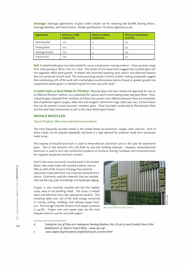
8/12/2019 Sustentable Urban Design
http://slidepdf.com/reader/full/sustentable-urban-design 127/134
120
d d c
s u s t a i n a b l e u r b a n
s i t e s
| M
A T E R I A L S
Recycled Steel Green Screen
P h o t o : G - S k y
Drainage: Drainage applications of glass cullet include use for retaining wall backll, footing drains,
drainage blankets, and French drains. Model specications for these applications are:
Applications Maximum CulletContent (%)
Maximum DebrisContent (%)
Minimum CompactionLevel (%)
Retaining Wall 100 5 95
Footing Drain 100 5 95
Drainage Blanket 100 5 90
French Drain 100 5 90
Soil: Crushed bottle glass has been tested for use as a hydroponic rooting medium. Glass particles range
from sizes passing a #8 to a #4 U.S. sieve. The results of one experiment suggest that crushed glass will
not negatively affect plant growth. A related test examined replacing sand used in manufactured topsoils
that are comprised of 50% sand. The most promising results in terms of plant rooting and growth suggest
that substituting 30% of the sand with crushed glass would produce plants of equal or greater growth size
compared to plants grown in standard topsoil mix that uses 50% sand.6
Crushed Glass as Sand Media for Filtration: Recycled glass has been tested and approved for use as
an effective ltration medium, as a substitute for natural sand in recirculating water and pool lters. Post-
industrial glass obtained from windows and doors has proven most effective because these are completely
free of potential organic (sugars, label, etc) and inorganic (aluminum rings, steel caps, etc.) contamination
that can be present in post-consumer container glass. Tests have been conducted by Pennsylvania State
and San Jose State Universities as well as the Clean Washington Center.
metals recycled
Typical Products: Most steel and aluminum products
The most frequently recycled metals in the United States are aluminum, copper, steel, and zinc. Each of
these metals can be recycled repeatedly and there is a high demand for products made from processed
metal scrap.
The majority of recycled aluminum is used to remanufacture aluminum cans or die casts for automotive
parts. Due to this demand, only 13% nds its way into building materials. However, remanufactured
aluminum is used in such site construction products as furniture, fencing, hardware, and component parts
for irrigation equipment and lawn mowers.
Steel is the most commonly recycled metal in the United
States. New steel made with recycled material uses as
little as 26% of the amount of energy that would be
required to make steel from raw materials extracted from
nature. Commonly used site materials that use recycled
steel are fencing, pipe, furnishings and landscape edging.
Copper is also routinely recycled and has the highest
scrap value of any building metal. The scrap is melted
down and reformed into a new, appropriate product . This
remelting takes only 15% of the total energy consumed
in mining, milling, smelting, and rening copper from
ore. The average recycled content of all copper products
is 44.6%. Copper wire and copper pipe are the most
frequent exterior uses for recycled copper.7
6 Testing the Use of Glass as a Hydroponic Rooting Medium (No. GL-96-2) and Crushed Glass Cullet
Replacement of Sand in Topsoil Mixes. <www.cwc.org>
7 www.copper.org/innovations/1998/06/recycle_overview.html

8/12/2019 Sustentable Urban Design
http://slidepdf.com/reader/full/sustentable-urban-design 128/134
121
d d c
s u s t a i n a b l e u r b a n
s i t e s
| M
A T E R I A L S
Zinc is both the least energy consumptive to produce from raw materials and is the least likely to be
recycled. The average recycled content of zinc in building products is less than 9%; very few landscape or
site materials are made exclusively of zinc.
organic waste recycled
Typical Products: Plant-derived compostBiosolid compost
Topsoil, whether available on site or imported from elsewhere, benets from the addition of organic
material. Compost is produced from a variety of sources and is useful as an organic amendment for in
situ or manufactured topsoil. Compost is made from a number of feedstocks including food processing
residuals, manure and agricultural by-products, forest product residuals, biosolids and sewage sludge,
yard trimmings and source-separated organic waste.
Due to the nature of these feedstocks, it is imperative to have
the materials tested. The Test Methods for the Examination of
Composting and Compost (TMECC) is the nation’s recognized
laboratory for establishing benchmark methods for compost
analysis. Test are conducted for 1) sampling procedures,2) physical properties, 3) inorganic chemistry properties,
4) organic and biological properties, 5) synthetic organic
compounds and 7) pathogens. The US EPA is in the process of
developing a Seal of Testing Assurance (STA) for the commercial
composting industry in an attempt to standardize testing
protocols and acceptable levels of compost performance.
Plant-Derived Compost: Compost products are the result
of biological degradation and transformation of plant-derived
materials under controlled conditions designed to promote
aerobic decomposition. Sources of this compost include yard
waste such as leaf litter, lawn clippings, nut and bean shell and
hulls. Suitable composts must be mature, stable and non-erodible. Model specications list the following requirements:
Fine compost sieve size: maximum 3% ner than 0.002 mm·
Coarse compost sieve size: 100% passing 3/8 “ screen·
pH range: 6.0-8.5·
Inert debris content: less than 5% on a dry weight or volume basis·
Minimum organic content: 40% by dry weight (Loss-on-Ignition test)·
Soluble Salt content: less than 6.0 mmhos/cm·
Full sample specication available:· www.metrokc.gov/procure/green/compost.htm
Biosolid Compost: Biosolids are a byproduct of wastewater treatment. After treatment in a wastewater
treatment facility, the liquid efuent is typically discharged into a nearby river and the solids are removed
from the treatment plant for disposal or benecial use. Converting municipal sewage sludge into usablecompost requires advanced biological treatment of biosolids. The process produces a stable, humus-like
material with a low organic content. Another process involves heat-drying the sludge to create pellets.
Macronutrients (nitrogen and phosphorous) and organic matter in biosolids are useful for both ne-
textured soils (clay) and coarse textures soils (sand). Organic matter can be added to clay soils to make
them looser or more friable and can increase the amount of pore space available for root growth. In sandy
soils, organic matter can increase the water-holding and nutrient capacity of the soil.
Disadvantages of biosolid compost vary depending on the characteristics of the wastewater entering the
wastewater treatment plant and the treatment processes used. Federal, state and local regulations have
reduced the types and quantity of pollutants in biosolids; nonetheless, heavy metals, pathogens and
P h o t o : M a t h e w s N i e l s e n L a n d s c a p e A r c h i t e c t s
Soil Inspection

8/12/2019 Sustentable Urban Design
http://slidepdf.com/reader/full/sustentable-urban-design 129/134
122
d d c
s u s t a i n a b l e u r b a n
s i t e s
| M
A T E R I A L S
organic chemicals may still be present. These can be used in NYC as long as the compost complies with DEC
regulations; NYC defers to DEC on contaminants. DEC defers the US EPA. For more information, go to A
Plain English Guide to the EPA Part 503 Biosolids Rule, at http://www.epa.gov/owm/mtb/biosolids/503pe/.
asphalt recycled
Typical Products: Recycled pavement
Recycled Asphalt Pavement (RAP) is milled asphalt and can be used to repair in-situ pavement or to
create new pavement from existing asphalt. According to the University of California Transportation Center,
about 90% of recovered RAP is reused to make new asphalt pavement. The advantages of using RAP are
the reduced use of non-renewable petroleum resources and virgin aggregates. Asphalt made using RAP
has a longer life cycle than conventional asphalt because the pavement is more water resistant. Asphalt
pavement using recycled asphalt content exhibits similar performance criteria to non-recycled mixes in
terms of rutting, raveling, weather resistance and fatigue cracking. Disadvantages include maintenance
of quality control over the stockpiles of RAP, availability, and local plant technology, which can limit the
amount of RAP in a particular mix. Within New York State, the amount of permissible RAP is 10-30% of
the total aggregate content.
There are four types of processes that use RAP:
1. Full-depth Reclamation: All of the asphalt section and a portion of the underlying base materials
are processed to produce a stabilized base course. The materials are crushed and additives
introduced; the materials are then shaped and compacted and a surface wearing course is
applied. Product ion rates vary from 300 to 1200 square yards per hour.
2. Hot, In-Place Recycling: The pavement is softened by heating and is scaried or hot-milled to a
depth of ¾ to 1 ½ inches and mixed. New hot mix material and/or a recycling agent is added with
a single pass of the machine. A new wearing course may also be laid with an additional pass after
compaction. Product ion rates vary from 1 to 2 lane-miles per day.
3. Hot Recycling: At a central plant, RAP is combined with hot new aggregate and asphalt or a
recycling agent to produce AC, using a batch or drum plant. The RAP is usually obtained from acold planing machine but could also be from a ripping/crushing operation.
4. Cold, In-Place Recycling: The pavement is removed by cold planing to a depth of 3 to 4 inches. The
material is pulverized, sized and mixed with an additive. Virgin aggregate can be added to modify
RAP characteristics. An asphalt emulsion or recycling agent is added, and then the material is
placed and compacted. According to the Asphalt Recycling and Reclaiming Association, cost
savings can range from 20 to 40 percent over conventional techniques.
There are some conditions where the milling and repaving process is cost effective and can be done in
one process using either one single machine or a “train” of three specialized machines. This is called
in-place recycling which eliminates costs associated with transporting, processing and stockpiling RAP.
Advantages to this one-step process include shorter construction time, less disruption to local trafc
patterns, cost-effectiveness, and less transportation-related environmental damage. This process may not
be appropriate in all conditions as the machines are extremely noisy and may violate local noise regulations.
It might be appropriate for large DDC projects that are not in a residential neighborhood, such as Remsen
Yard or Harper Street Yard.
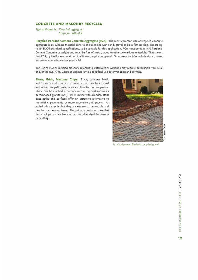
8/12/2019 Sustentable Urban Design
http://slidepdf.com/reader/full/sustentable-urban-design 130/134
123
d d c
s u s t a i n a b l e u r b a n
s i t e s
| M
A T E R I A L S
concrete and masonry recycled
Typical Products: Recycled aggregateChips for paths/ll
Recycled Portland Cement Concrete Aggregate (RCA): The most common use of recycled concrete
aggregate is as subbase material either alone or mixed with sand, gravel or blast furnace slag. According
to NYSDOT standard specications, to be suitable for this application, RCA must contain 95% PortlandCement Concrete by weight and must be free of metal, wood or other deleterious materials. That means
that RCA, by itself, can contain up to 5% sand, asphalt or gravel. Other uses for RCA include riprap, reuse
in cement concrete, and as general ll.
The use of RCA or recycled masonry adjacent to waterways or wetlands may require permission from DEC
and/or the U.S. Army Corps of Engineers via a benecial use determination and permits.
Stone, Brick, Masonry Chips: Brick, concrete block,
and stone are all sources of material that can be crushed
and reused as path material or as llers for porous pavers.
Stone can be crushed even ner into a material known as
decomposed granite (DG). When mixed with a binder, stone
dust paths and surfaces offer an attractive alternative tomonolithic pavements or more expensive unit pavers. An
added advantage is that they are somewhat permeable and
can be used around trees. The primary limitations are that
the small pieces can track or become dislodged by erosion
or scufng.
Eco-Grid pavers, lled with recycled gravel
P h o t o : H a n o v e r P a v e r s

8/12/2019 Sustentable Urban Design
http://slidepdf.com/reader/full/sustentable-urban-design 131/134

8/12/2019 Sustentable Urban Design
http://slidepdf.com/reader/full/sustentable-urban-design 132/134
125
d d c
s u s t a i n a b l e u r b a n
s i t e s
| M
A T E R I A L S
coal and y ash
American Coal Ash Association· www.acaa.org
Fly Ash Facts for Highway Engineers· http://www.fhwa.dot.gov/pavement/fatoc.htm
Concrete mixes incorporating y ash·
http://www2.cityofseattle.net/util/engineeringArticleView.asp?ArticleID=9-23.9#9-23.9
FHA: Slag use in Portland Cement Concrete·
http://www.tfhrc.gov/hnr20/recycle/waste/begin.htm
Slag Cement Association· www.slagment.org
purchasing laws
NYC Environmentally Preferable Purchasing (EPP) Minimum Standards for Construction Products·
(Draft)
NYC Environmentally Preferable Purchasing (EPP) Minimum Standards for Goods (Draft)·
New York City Local Laws 118, 119, 120, 121 and 123, effective January 1, 2007·

8/12/2019 Sustentable Urban Design
http://slidepdf.com/reader/full/sustentable-urban-design 133/134
d d c s u s t a i n a b l e u r b a n
s i t
e s | A C K N O W L E D G E M E N T S
acknowledgements
The Sustainable Urban Site Design Manual is a collaborative effort made by New Yorkers who want to
improve our urban sites and make NYC a greener place. Special thanks go to the following individuals
for their gracious contributions of time and expertise.
mathews nielsen landscape architects pc
Signe Nielsen, FASLAJessica Osserman
Tricia Martin
gruzen samton architects llp
Susan Drew, AIA LEED APClaibourn Hamilton
Jenna Widman
new york cityLaurie Kerr, RA, LEED APMayor’s Ofce of Long Term Planningand Sustainability
Kerry CarnahanBruce Hendler, RLA
Department of Design and Construction
Of the following NYC peer reviewers acknowledged, special thanks goes to the Department of
Environmental Protection and Law Department contributors, for their patient and thorough clarication
of City stormwater regulations and management.
new york city peer reviewers
Laurie Kerr, RA, LEED AP
Carter H. Strickland, Jr.
Mayor’s Ofce of Long Term Planning and Sustainability
Amanda C. Goad
Hilary Meltzer
Environmental Law Division, Law Department
Magdi Farag
Helen Forgione
Kathryn GarciaJim Garin
Angela Licata
Warren Liebold
John McLaughlin
Stacy Radine
David Ramia
Esther Siskind
Julie Stein Kaplan
Constance Vavilis
Department of Environmental Protection
Jen Becker
Len Greco
David Kane
Economic Development Corporation
Deborah F. Taylor, AIA, LEED AP
Department of Buildings
Howard Slatkin
Department of City Planning
Bram Gunther
Department of Parks and Recreation
Wendy Feuer
Michael Flynn
Kedari Reddy
Andy Wiley-Schwartz
Department of Transportation

8/12/2019 Sustentable Urban Design
http://slidepdf.com/reader/full/sustentable-urban-design 134/134