Study Area Characterization Work Plan Addendum Number 2 · 1 Study Area Characterization Work Plan...
23
1 Study Area Characterization Work Plan Addendum Number 2 Additional Field Investigation Activities Site Name and Location: Study Area, Corning, NY Order on Consent and Administrative Settlement: NYSDEC Project ID 851046 Corning Incorporated Project Coordinator: Mike Ford NYSDEC Project Coordinator: Gregory B. MacLean Date: May 11, 2015 Introduction Weston Solutions, Inc. (WESTON ® ), on behalf of Corning Incorporated (Corning), has prepared this Work Plan Addendum Number 2 for additional field investigation activities within the Study Area to supplement the approved Study Area Characterization Work Plan (Work Plan; WESTON, June 2014) being implemented pursuant to the Order on Consent and Administrative Settlement between the New York State Department of Environmental Conservation (NYSDEC) and Corning (Order on Consent). The Study Area is bounded by Pyrex Street on the west, E. Pulteney Street on the north, Post Creek on the east and the Chemung River on the south. The additional field investigation activities are being conducted to: 1. Determine the nature and extent of surface soil concentrations greater than NYSDEC Subpart 375-6 Remedial Program Residential Soil Cleanup Objectives (Residential SCOs), excluding iron, in samples collected at residential properties in the Study Area. 2. Assess residential properties within the Study Area where a layer of fill material containing ash, brick and/or glass was observed in soil borings installed in adjacent City of Corning rights-of-way. A layer of fill material is defined as non- native material containing ash, brick and/or glass with a thickness of greater than 1 inch. 3. Assess residential properties within the Study Area where the presence of ash, brick and/or glass has been observed and reported to NYSDEC. 4. Assess the nature and extent of a layer of fill material containing ash, brick and/or glass observed in soil borings in City of Corning rights-of-way in the northwest corner of the Study Area. 5. Assess areas within the Study Area on City of Corning properties and rights-of- way at which NYSDEC stated in correspondence to Corning dated January 8,
Transcript of Study Area Characterization Work Plan Addendum Number 2 · 1 Study Area Characterization Work Plan...
1
Study Area Characterization Work Plan Addendum Number 2 Additional Field Investigation Activities
Site Name and Location: Study Area, Corning, NY
Order on Consent and Administrative Settlement: NYSDEC Project ID 851046
Corning Incorporated Project Coordinator: Mike Ford
NYSDEC Project Coordinator: Gregory B. MacLean
Date: May 11, 2015
Introduction
Weston Solutions, Inc. (WESTON®), on behalf of Corning Incorporated (Corning), has prepared this Work Plan Addendum Number 2 for additional field investigation activities within the Study Area to supplement the approved Study Area Characterization Work Plan (Work Plan; WESTON, June 2014) being implemented pursuant to the Order on Consent and Administrative Settlement between the New York State Department of Environmental Conservation (NYSDEC) and Corning (Order on Consent). The Study Area is bounded by Pyrex Street on the west, E. Pulteney Street on the north, Post Creek on the east and the Chemung River on the south.
The additional field investigation activities are being conducted to:
1. Determine the nature and extent of surface soil concentrations greater than NYSDEC Subpart 375-6 Remedial Program Residential Soil Cleanup Objectives (Residential SCOs), excluding iron, in samples collected at residential properties in the Study Area.
2. Assess residential properties within the Study Area where a layer of fill material containing ash, brick and/or glass was observed in soil borings installed in adjacent City of Corning rights-of-way. A layer of fill material is defined as non-native material containing ash, brick and/or glass with a thickness of greater than 1 inch.
3. Assess residential properties within the Study Area where the presence of ash, brick and/or glass has been observed and reported to NYSDEC.
4. Assess the nature and extent of a layer of fill material containing ash, brick and/or glass observed in soil borings in City of Corning rights-of-way in the northwest corner of the Study Area.
5. Assess areas within the Study Area on City of Corning properties and rights-of-way at which NYSDEC stated in correspondence to Corning dated January 8,
Study Area Characterization Work Plan Addendum Number 2 Additional Field Investigation Activities
Study Area, Corning, NY NYSDEC Project ID 851046 (continued)
2
2015, that City of Corning personnel reported to NYSDEC that they have observed the presence of ash, brick and/or glass.
6. Perform additional investigations, at the request of NYSDEC, to supplement the soil boring data collected to date in the Study Area.
Sampling activities will be performed using the methods and procedures described in Section 4.2, Appendix B (Community Air Monitoring Plan) and Appendix D (Standard Operating Procedures) of the Work Plan. Samples will be analyzed for the constituents discussed below using the methodologies described in Section 4.2.6 and Appendix C (Quality Assurance Project Plan) of the Work Plan.
Upon approval by NYSDEC, work under this Work Plan Addendum Number 2 will be performed as a supplemental scope of work pursuant to Section III.B.1 of the Order on Consent.
I. Residential Area – Properties with Surface Soil Samples above Residential SCOs
Background:
In accordance with the Work Plan, 163 properties were sampled in the Residential Area of the Study Area between September 8, 2014 and December 18, 2014. Sampling was conducted in two phases based on the ability to obtain written consent to access from the owners of properties sampled.
Surface soil samples were collected at four (4) locations at each property at which written consent to access was received, from a depth of 0 to 2 inches below ground surface (in bgs) excluding the ground cover or sod layer. A total of 654 primary samples were collected during the Residential Area surface soil sampling. In accordance with the Work Plan, samples focused on areas of bare soil, high traffic areas, gardens, playgrounds, downspouts and areas where the property owner described ash, brick or glass as having been observed.
At 127 of the properties sampled (a total of 508 primary samples), analytical results for all four surface soil samples were at or below the Residential SCOs, excluding iron. At 36 of the properties sampled, analytical results in at least one sample had concentrations above the Residential SCOs, excluding iron. See Table 1 attached to this Work Plan Addendum Number 2 for a list of the 36 properties. Additional field investigation activities are proposed at these 36 properties to determine the nature and extent of surface soil concentrations greater than NYSDEC Residential SCOs, excluding iron.

Study Area Characterization Work Plan Addendum Number 2 Additional Field Investigation Activities
Study Area, Corning, NY NYSDEC Project ID 851046 (continued)
3
Additional Sampling Activities:
Written consent to access from individual property owners will be needed prior to conducting the additional field investigation activities. To ensure that the field work can be conducted expeditiously, safely, and with minimal impact to the community, field work will be scheduled after receipt of a majority of the written consents to access.
At each of the 36 properties, a combination of surface soil samples, shallow soil samples, and deeper soil samples will be collected.
Surface soil samples (0 to 2 in bgs excluding the ground cover or sod layer) will be collected on an approximate 30 foot by 30 foot grid established at each of the 36 properties. Approximately of eight (8) to 12 samples will be collected per property in addition to the previously collected four (4) samples. All samples will be analyzed for Target Analyte List (TAL) metals plus mercury.
At four (4) of the surface soil sample locations at each of the 36 properties, shallow soil borings will be installed to a depth of 4 feet below ground surface (ft bgs). In general, one of these shallow soil borings will be installed in each of four quadrants on the property. One surface soil and one shallow soil boring location will be biased toward (1) a location on a property, if any, where the property owner reports that s/he has observed the presence of ash, brick and/or glass, or (2) a surface soil sample location, if any, where ash, brick and/or glass is observed during sampling. Two (2) samples will be collected from each shallow soil boring; one sample from 2 in to 2 ft bgs and one sample from 2 ft to 4 ft bgs. All samples will be analyzed for TAL metals plus mercury.
If there are vegetable gardens at any of the 36 properties, composite soil samples will be collected from within the garden using the sampling approach described in Attachment A to this Work Plan Addendum Number 2.1 All samples will be analyzed for TAL Metals plus mercury.
In addition, two (2) deeper soil borings will be installed to a depth of 15 ft bgs at each of the 36 properties. In general, one soil boring will be installed in the front yard, and one in the backyard.
If a layer of fill material containing ash, brick and/or glass is observed in either of these two (2) deeper borings, or in any of the four (4) shallow soil borings, two (2) to four (4)
1 For samples collected from vegetable gardens, field notes will include a description of soil conditions, in particular if imported soil is observed and/or noted as described in Attachment A to this Work Plan Addendum Number 2.
Study Area Characterization Work Plan Addendum Number 2 Additional Field Investigation Activities
Study Area, Corning, NY NYSDEC Project ID 851046 (continued)
4
additional deeper soil borings will be installed to delineate the horizontal and/or vertical extent of the layer of fill material. A layer of fill material is defined as non-native material containing ash, brick and/or glass with a thickness of greater than 1 inch.
If a layer of fill material is encountered while drilling a deeper soil boring, up to four (4) soil samples will be collected per boring: one from the soil at 2 in to 2 ft bgs excluding the ground cover or sod layer; one from 2 ft bgs to 4 ft bgs if present above the layer of fill material; one from the layer of fill material; and one from the native material beneath the layer of fill material. Samples will be analyzed for TAL metals plus mercury, Target Compound List (TCL) semi-volatile organic compounds (SVOCs) as listed in Table 4-3 of the Work Plan, and Toxicity Characteristic Leaching Procedure (TCLP) Resource Conservation Recovery Act (RCRA) metals.
In borings where no layer of fill material is encountered, three (3) soil samples will be collected per boring; one from the soil at 2 in to 2 ft bgs excluding the ground cover or sod layer, one from 2 ft bgs to 4 ft bgs, and one sample of the native material at depth. Samples will be analyzed for TAL metals plus mercury.
At properties RES002, RES096, and RES138, for which one surface sample on each property had SVOC concentrations above the Residential SCOs; surface soil samples will also be collected for SVOC analysis, extracted by the laboratory and held. Samples collected at grid nodes adjacent to the sample location with the SVOC concentrations above the Residential SCOs will be analyzed. If preliminary results indicate concentrations above the Residential SCOs, samples collected from the next adjacent grid nodes will be analyzed. This process will be repeated, as necessary, to allow determination of the horizontal extent of SVOCs above the Residential SCOs in the surface soils. In addition, one of the shallow soil borings (to 4 ft bgs) will be installed and sampled at the location of the original sample location at which the SVOC concentrations were above the Residential SCOs. Two (2) samples will be collected from this shallow soil boring; one sample from 2 in to 2 ft bgs and one sample from 2 ft to 4 ft bgs. All samples will be analyzed for TAL metals plus mercury, and samples will also be collected for SVOC analysis extracted by the laboratory and held. The sample from the 2 in to 2 ft bgs interval will be analyzed. If preliminary results indicate concentrations above the Residential SCOs, the sample from the 2 ft to 4 ft bgs interval will be analyzed.
Surface and shallow soil samples will be collected using a small Geoprobe rig, a hand-held steel soil auger, or a hand-held scoop using methods and procedures described in Section 4.2 and Appendix D (Standard Operating Procedures) of the Work Plan. Deeper soil borings will be advanced via Geoprobe using methods described in Section 4.2.3 and Appendix D (Standard Operating Procedures) of the Work Plan. Samples will be

Study Area Characterization Work Plan Addendum Number 2 Additional Field Investigation Activities
Study Area, Corning, NY NYSDEC Project ID 851046 (continued)
5
collected from the soil borings installed via Geoprobe using a 2-inch diameter, 4-foot-long, macrocore sampler in accordance with Section 4.2.3 of the Work Plan.
II. Residential Properties in the Northwest Corner of the Study Area
Background:
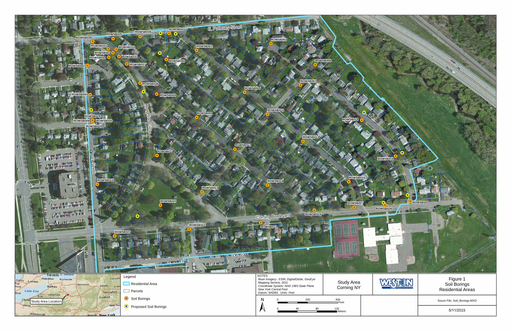
In accordance with Addendum Number 1 to the Work Plan, a total of 13 soil borings were installed in City of Corning rights-of-way in the northwest corner of the Study Area to assess the horizontal extent of a layer of fill material containing ash, brick and glass encountered in soil boring ROWSB001. A layer of fill material containing ash, brick and/or glass was observed in 11 of these soil borings. Additional field investigation activities are proposed at 13 residential properties in this area in addition to the 36 properties discussed in Section I above. See Table 2 attached to this Addendum Number 2 for a list of the 13 properties.
Additional Sampling Activities:
Written consent to access from individual property owners will be needed prior to conducting the additional field investigation activities. To ensure that the field work can be conducted expeditiously, safely, and with minimal impact to the community, field work will be scheduled after receipt of a majority of the written consents to access.
At each of the 13 properties, a combination of surface soil samples, shallow soil samples, and deeper soil samples will be collected.
Surface soil samples (0 to 2 in bgs excluding the ground cover or sod layer) will be collected on an approximate 30 foot by 30 foot grid established at each of the 13 properties. Approximately eight (8) to 12 samples will be collected per property. All samples will be analyzed for TAL metals plus mercury.
At four (4) of the surface soil sample locations at each of the 13 properties, shallow soil borings will be installed to a depth of 4 ft bgs. In general, one of these shallow soil borings will be installed in each of four quadrants on the property. One surface soil and one shallow soil boring location will be biased toward (1) a location on the property, if any, where the property owner(s) reports that s/he has observed the presence of ash, brick and/or glass, or (2) a surface soil sample location, if any, where ash, brick and/or glass is observed during sampling. Two (2) samples will be collected from each shallow soil boring; one sample from 2 in to 2 ft bgs and one sample from 2 ft to 4 ft bgs. All samples will be analyzed for TAL metals plus mercury.

Study Area Characterization Work Plan Addendum Number 2 Additional Field Investigation Activities
Study Area, Corning, NY NYSDEC Project ID 851046 (continued)
6
If there are vegetable gardens at any of the 13 properties, composite soil samples will be collected from within the garden using the sampling approach described in Attachment A to this Work Plan Addendum Number 2.2 All samples will be analyzed for TAL Metals plus mercury.
In addition, two (2) deeper soil borings will be installed to a depth of 15 ft bgs at each of the 13 properties. In general, one soil boring will be installed in the front yard, and one in the backyard.
If a layer of fill material is encountered while drilling the deeper soil borings, up to four (4) soil samples will be collected per boring: one from the soil at 2 in to 2 ft bgs excluding the ground cover or sod layer; one from 2 ft bgs to 4 ft bgs if present above the layer of fill material; one from the layer of fill material; and one from the native material beneath the layer of fill material. Samples will be analyzed for TAL metals plus mercury, SVOCs and TCLP metals. A layer of fill material is defined as non-native material containing ash, brick and/or glass with a thickness of greater than 1 inch.
In borings where no layer of fill material is encountered, three (3) soil samples will be collected per boring; one from the soil at 2 in to 2 ft bgs excluding the ground cover or sod layer, one from 2 ft bgs to 4 ft bgs, and one sample of the native material at depth. Samples will be analyzed for TAL metals plus mercury.
Surface and shallow soil samples will be collected using a small Geoprobe rig, a hand-held steel soil auger, or a hand-held scoop using methods and procedures described in Section 4.2 and Appendix D (Standard Operating Procedures) of the Work Plan. Deeper soil borings will be advanced via Geoprobe using methods described in Section 4.2.3 and Appendix D (Standard Operating Procedures) of the Work Plan. Samples will be collected from the soil borings installed via Geoprobe using a 2-inch diameter, 4-foot-long, macrocore sampler in accordance with Section 4.2.3 of the Work Plan.
III. Residential Area – Properties where the presence of ash, brick and/or glass has been reported to NYSDEC
Background:
Additional field investigation activities are proposed to be conducted at 37 properties as requested by NYSDEC and listed in Table 3 to this Work Plan Addendum Number 2.
2 For samples collected from vegetable gardens, field notes will include a description of soil conditions, in particular if imported soil is observed and/or noted as described in Attachment A to this Work Plan Addendum Number 2.

Study Area Characterization Work Plan Addendum Number 2 Additional Field Investigation Activities
Study Area, Corning, NY NYSDEC Project ID 851046 (continued)
7
These additional field investigations are proposed to assess the potential of a layer of fill material containing ash, brick and/or glass, and if present determine the nature and extent of that material. Table 3 is based on:
Properties where the observance of ash, brick and/or glass has been reported to NYSDEC and NYSDEC identified the properties in correspondences to Corning dated January 8, 2015 and March 5, 2015.
Properties at which a property owner reported to WESTON during Residential Area sampling that the property owner has observed ash, brick and/or glass.
Properties at which WESTON observed ash, brick or glass during the Residential Area sampling.
At the request of NYSDEC, three (3) properties along Corning Boulevard. NYSDEC requests this sampling because of the proximity of a layer of fill material containing ash, brick and/or glass observed in soil borings installed in the City of Corning rights-of-way adjacent to the properties in December 2014.
The residential sampling occurred between September 8, 2014 and December 18, 2014. Table 3 does not include properties already listed in Sections I and II of this Work Plan.
If reports of the observance of ash, brick and/or glass on additional properties are presented to NYSDEC prior to the initiation of field work under this Work Plan Addendum Number 2, such properties will be added to the sampling program listed below, provided that NYSDEC determines there is credible evidence of the presence of ash, brick and/or glass, and the property is not already included in properties to be investigated under Sections I and II above. Credible evidence includes the identification of specific locations; more than small quantities of ash, brick and/or glass; materials observed at depth: and/or the observance of a layer of fill material containing ash, brick and/or glass.
Additional Sampling Activities:
Written consent to access from individual property owners will be needed prior to conducting the additional field investigation activities. To ensure that the field work can be conducted expeditiously, safely, and with minimal impact to the community, field work will be scheduled after receipt of a majority of the written consents to access.
Study Area Characterization Work Plan Addendum Number 2 Additional Field Investigation Activities
Study Area, Corning, NY NYSDEC Project ID 851046 (continued)
8
If there are vegetable gardens at any of the 37 properties, composite soil samples will be collected from within the garden using the sampling approach described in Attachment A to this Work Plan Addendum Number 2.3 All samples will be analyzed for TAL Metals plus mercury.
At each of the 37 properties, one (1) to two (2) soil borings will be installed at locations where property owners report that they have observed the presence of ash, brick and/or glass. Soil borings will be advanced via Geoprobe to 15 feet bgs using methods described in Section 4.2.3 and Appendix D (Standard Operating Procedures) of the Work Plan. Samples will be collected from the soil borings using a 2-inch diameter, 4-foot-long, macrocore sampler in accordance with Section 4.2.3 of the Work Plan.
If a layer of fill material containing ash, brick and/or glass is observed in these soil borings, two (2) to four (4) additional soil borings will be installed to delineate the horizontal extent of the layer of fill material.
If a layer of fill material is encountered during drilling of a soil boring, up to four (4) soil samples will be collected per boring: one from the soil at 2 in to 2 ft bgs excluding the ground cover or sod layer; one from 2 ft bgs to 4 ft bgs if present above the layer of fill material; one from the layer of fill material; and one from the native material beneath the layer of fill material. Samples will be analyzed for TAL metals plus mercury, SVOCs and TCLP metals.
In soil borings where no layer of fill material is encountered, up to three (3) soil samples will be collected. If the native soil is encountered at depths greater than 4 ft bgs, three (3) soil samples will be collected per boring; one from the soil at 2 in to 2 ft bgs excluding the ground cover or sod layer, one from 2 ft bgs to 4 ft bgs, and one sample of the native material in the shallowest interval it occurs. If native soil is encountered at 2 to 4 ft bgs, two (2) soil samples will be collected per boring; one from the soil at 2 in to 2 ft bgs excluding the ground cover or sod layer, and one from the native material at the shallowest interval it occurs. If native soil is encountered less than 2 ft bgs, one (1) soil samples will be collected per boring the native material at the shallowest interval it occurs. Samples will be analyzed for TAL metals plus mercury.
3 For samples collected from vegetable gardens, field notes will include a description of soil conditions, in particular if imported soil is observed and/or noted as described in Attachment A to this Work Plan Addendum Number 2.

Study Area Characterization Work Plan Addendum Number 2 Additional Field Investigation Activities
Study Area, Corning, NY NYSDEC Project ID 851046 (continued)
9
IV. Adjacent Residential Properties
If field observations appear to indicate a layer of fill material containing ash, brick and/or glass extends from an individual property to an adjacent property within the Study Area that is not already included in the sampling program discussed in Sections I, II and III of this Work Plan Addendum Number 2 the WESTON Field Team Leader or Project Manager will verbally notify NYSDEC’s representative present in the Study Area or NYSDEC’s Project Manager. If NYSDEC determines that additional investigations are required on the adjacent property within the Study Area, NYSDEC will notify the property owner of such adjacent property and determine if the property owner is willing to grant written consent to access for the work. Within a week of NYSDEC’s notifying Corning in writing that the property owner is willing to grant written consent to access, Corning will mail an agreement seeking consent to access to the property owner to perform sampling as discussed in Section III above. The field work will be scheduled promptly upon Corning’s receipt of the written consent for access, signed by the property owner.
V. City of Corning Properties and Rights-of-Way
Background:
In accordance with Addendum Number 1 to the Work Plan, a total of 13 soil borings were installed in City of Corning rights-of-way in the northwest corner of the Study Area to assess the horizontal extent of a layer of fill material containing ash, brick and glass encountered in soil boring ROWSB001. A layer of fill material containing ash, brick and/or glass was observed in 11 of these 13 soil borings. Additional field investigation activities are proposed in City of Corning rights-of-way in this area to further define the horizontal extent of the layer of fill material containing ash, brick and/or glass.
In addition, in accordance with Addendum Number 1 to the Work Plan, a total of three (3) soil borings were installed in City of Corning rights-of-way at the Eastern End of Corning Boulevard to determine the horizontal extent of a layer of fill material containing ash, brick and glass observed in this area. A layer of fill material containing ash, brick and/or glass was observed in two (2) of these soil borings. Additional field investigation activities are proposed in City of Corning rights-of-way in this area to further define the horizontal extent of the layer of fill material containing ash, brick and/or glass.
In correspondence to Corning dated January 8, 2015, NYSDEC identified the following areas within the Study Area where City of Corning personnel told NYSDEC that they have observed the presence of ash, brick and/or glass: “length of Roosevelt Street to the
Study Area Characterization Work Plan Addendum Number 2 Additional Field Investigation Activities
Study Area, Corning, NY NYSDEC Project ID 851046 (continued)
10
levee side of adjacent properties based on corrosion of water lines in this area”, “the water main under Corning Boulevard from about Wilson Street to the east end”, and “the west end of [Houghton] park near a large oak tree”. Additional field investigation activities are proposed in these areas to assess whether a layer of fill material containing ash, brick and/or glass is present, and, if present, to determine the nature and extent of the material. It should be noted that three (3) soil borings (ROWSB025, ROWSB026, and ROWSB027) were previously installed along the north side of Corning Boulevard under the approved Study Area Characterization Work Plan Addendum Number 1.
Additional Sampling Activities:
A total of ten (10) soil borings will be installed within City of Corning properties and rights-of-way at the locations shown on Figure 1 attached to this Work Plan Addendum Number 2 to assess whether a layer of fill material containing ash, brick and/or glass is present, and, if present, to determine the nature and extent of the material. Soil borings will be installed as described below:
Five (5) soil borings will be installed in City of Corning rights-of-way in the northwest corner of the Study Area to define the horizontal extent of the layer of fill material containing ash, brick and/or glass.
Two (2) soil borings will be installed in City of Corning rights-of-way at the Eastern End of Corning Boulevard to define the horizontal extent of the layer of fill material containing ash, brick and/or glass.
Two (2) soil borings will be installed within City of Corning rights-of way along the east side of Roosevelt Avenue, to investigate an area where City of Corning officials have reported to NYSDEC the observance the presence of ash, brick and/or glass.
One (1) soil boring will be installed in the west end of Houghton Park to investigate an area where City of Corning officials have reported to NYSDEC the observance of the presence of ash, brick and/or glass.
Soil borings will be advanced via Geoprobe to 15 feet bgs using methods described in Section 4.2.3 and Appendix D (Standard Operating Procedures) of the Work Plan. Samples will be collected from the soil borings using a 2-inch diameter, 4-foot-long, macrocore sampler in accordance with Section 4.2.3 of the Work Plan.

Study Area Characterization Work Plan Addendum Number 2 Additional Field Investigation Activities
Study Area, Corning, NY NYSDEC Project ID 851046 (continued)
11
If a layer of fill material containing ash, brick and/or glass is observed in the soil boring in Houghton Park, two to four additional soil borings will be installed in Houghton Park to delineate the horizontal extent of the layer of fill material.
If a layer of fill material is encountered during drilling of the borings, three (3) soil samples will be collected per boring; one from the soil at 2 in to 2 ft bgs excluding the ground cover or sod layer; one from the layer of observed fill material; and one from the native material beneath the layer of fill material. Samples will be analyzed for TAL metals plus mercury, SVOCs and TCLP metals.
In soil borings where no layer of fill material is encountered, two (2) soil samples will be collected per boring; one from the soil at 2 in to 2 ft bgs excluding the ground cover or sod layer; and one from the native material at depth. This sample will be collected from the shallowest interval where native soil is encountered. Samples will be analyzed for TAL metals plus mercury.
VI. Test Pits
Background:
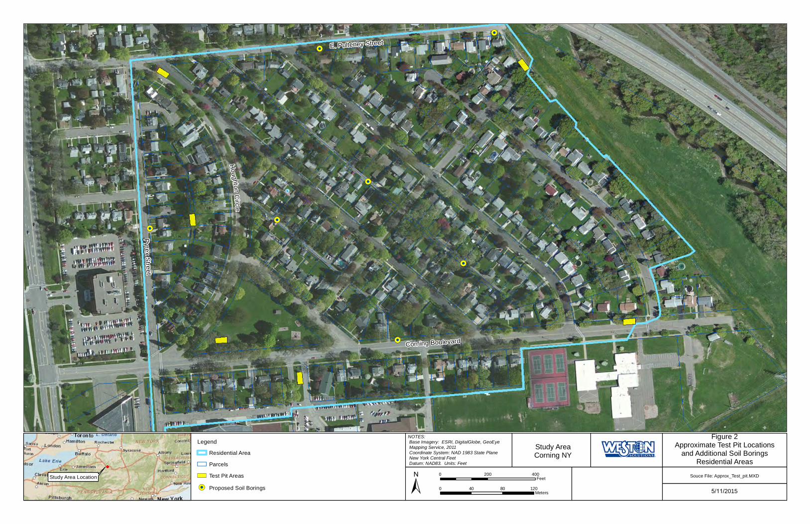
In correspondence to Corning dated February 26, 2015, NYSDEC requested test pit investigations at 16 areas in the Study Area to supplement the boring program. To accommodate this request, limited test pitting is proposed at seven (7) of these areas. At another seven (7) of these areas, soil borings, instead of test pits, are proposed to investigate the potential presence of a layer of fill material containing ash, brick and/or glass. The remaining two (2) areas will be addressed under investigations proposed at residential properties discussed in Sections I and III above. The approximate locations of the proposed test pits and soil borings are shown on Figure 2 attached to this Addendum Number 2.
Four (4) test pits are proposed to be installed in areas where ash, brick and/or glass has been observed but soil borings have not shown a layer of fill material. The purpose of these test pits would be to investigate the heterogeneity of subsurface soils in the Study Area. The four (4) areas where test pits are proposed are:
West end of Houghton Park
Corning-Painted Post School District property entrance along Corning Boulevard
North end of Argonne Street
Study Area Characterization Work Plan Addendum Number 2 Additional Field Investigation Activities
Study Area, Corning, NY NYSDEC Project ID 851046 (continued)
12
Center of City of Corning rights-of-way between Houghton Circle and Pyrex Street
Two (2) test pits are proposed to be installed in areas where a layer of fill material containing ash, brick and/or glass has been observed in soil borings. The purpose of these test pits would be to show the subsurface soil conditions and visually observe the layer of fill material. The two (2) areas where test pits are proposed are:
Northwestern corner of the Study Area in the median in Houghton Circle
Eastern End of Corning Boulevard between Wilson Street and Roosevelt Street
One (1) test pit is proposed at properties, RES051, RES052, and RES064, at each of which it has been reported to NYSDEC that fill material was brought onto a property to raise the elevation of the backyard. The purpose of these three (3) test pits would be to investigate the heterogeneity of the placed fill material. As noted above in Sections I and III above, soil borings will be installed at these properties prior to installation of the test pit. If a layer of fill material is observed and delineated in these soil borings, the test pit will be eliminated from the planned work.
Seven (7) additional soil borings will be installed in lieu of test pits in City of Corning rights-of-way to investigate the potential presence of a layer of fill material containing ash, brick and/or glass.
Additional Sampling Activities – Test Pits:
Shallow test pits up to 4 ft bgs will be installed at the seven (7) areas described above. The test pits will be installed using a mini excavator and/or backhoe to minimize the disruption to the Residential Area. Each test pit will be approximately 1 foot to 18 inches wide, 4 to 7 feet long and up to 4 feet deep. No sloping, trenching or shoring of the test pit side walls will be required.
Test pits will be excavated in a systematic manner to slowly expose the subsurface soils in thin lifts (approximately 6 inches or less). If a layer of fill material containing ash, brick and/or glass is observed in the test pit, the excavation will cease and any material excavated from the layer of fill material will be containerized and handled as investigative derived waste (IDW) in accordance with Section 4.2.9 of the Work Plan. A layer of fill material is defined as non-native material containing ash, brick and/or glass with a thickness of greater than 1 inch and a horizontal extent of 1 foot or more. It does not include isolated pieces of ash, brick and/or glass.
Study Area Characterization Work Plan Addendum Number 2 Additional Field Investigation Activities
Study Area, Corning, NY NYSDEC Project ID 851046 (continued)
13
The excavated soil will be placed onto plastic sheeting next to the test pit location. The soil will be described in accordance with the methods contained in Section 4.2.4 of the Work Plan. Prior to test pitting, all reasonable efforts will be made to remove the cover material/sod layer (if present) in a manner such that it can be restored following backfilling.
If a layer of fill material containing ash, brick and/or glass is observed in a test pit, up to three (3) soil samples will be collected from the material excavated from the test pit. Samples will be analyzed for TAL metals plus mercury, SVOCs and TCLP metals.
In addition, if a layer of fill material containing ash, brick and/or glass is observed in a test pit, two (2) to four (4) additional deeper soil borings will be installed to delineate the horizontal and/or vertical extent of the layer of fill material. Up to four (4) soil samples will be collected per boring: one from the soil at 0 to 2 ft bgs excluding the ground cover or sod layer; one from 2 ft bgs to 4 ft bgs if present above the layer of fill material; one from the layer of fill material; and one from the native material beneath the layer of fill material. Samples will be analyzed for TAL metals plus mercury, SVOCs and TCLP metals.
In test pits where no layer of fill material is observed, but pieces of ash, brick and/or glass are observed, up to three (3) soil samples will be collected per test pit in the vicinity of the observed pieces of ash, brick and/or glass. Samples will be analyzed for TAL metals plus mercury, SVOCs and TCLP metals. In addition, one sample of the native soil at depth will be collected from the bottom of the test pit and analyzed for TAL metals plus mercury.
In test pits where no layer of fill material and no pieces of ash, brick and/or glass are observed one sample of the native soil at depth will be collected from the bottom of the test pit and analyzed for TAL metals plus mercury.
In test pits where no layer of fill material is observed, one soil boring will be installed to 15 ft bgs in the center of the test pit, following backfilling, to investigate the soils beneath 4 ft bgs. If a layer of fill material is observed in this soil boring, two (2) soil samples will be collected: one from the layer of fill material; and one from the native material beneath the layer of fill material. Samples will be analyzed for TAL metals plus mercury, SVOCs and TCLP metals. In addition, if a layer of fill material containing ash, brick and/or glass is observed in this soil boring beneath the test pit, two (2) to four (4) additional deeper soil borings will be installed to delineate the horizontal extent of the layer of fill material. Up to four (4) soil samples will be collected per boring: one from the soil at 0 to 2 ft bgs excluding the ground cover or sod layer; one from 2 ft bgs to 4 ft bgs if present above the
Study Area Characterization Work Plan Addendum Number 2 Additional Field Investigation Activities
Study Area, Corning, NY NYSDEC Project ID 851046 (continued)
14
layer of fill material; one from the layer of fill material; and one from the native material beneath the layer of fill material. Samples will be analyzed for TAL metals plus mercury, SVOCs and TCLP metals.
Soil samples will be collected using a hand-held steel soil auger or a hand-held scoop using methods and procedures described in Section 4.2 and Appendix D (Standard Operating Procedures) of the Work Plan.
Following sampling, the excavated material, with the exception of the material from an observed layer of fill material containerized separately as described above, will be placed back into the test pit excavation, followed by the cover material. If additional backfill material is required, this material will be obtained from a NYSDEC-approved backfill source.
Additional Sampling Activities – Soil Borings:
Soil borings will be advanced via Geoprobe to 15 feet bgs using methods described in Section 4.2.3 and Appendix D (Standard Operating Procedures) of the Work Plan. Samples will be collected from the soil borings using a 2-inch diameter, 4-foot-long, macrocore sampler in accordance with Section 4.2.3 of the Work Plan.
If a layer of fill material containing ash, brick and/or glass is observed, one (1) to two (2) additional soil borings will be installed in the vicinity of these borings to delineate the horizontal extent of the layer of fill material.
If a layer of fill material is encountered during drilling of the borings, three (3) soil samples will be collected per boring; one from the soil at 2 in to 2 ft bgs excluding the ground cover or sod layer; one from the layer of observed fill material; and one from the native material beneath the layer of fill material. Samples will be analyzed for TAL metals plus mercury, SVOCs and TCLP metals.
In soil borings where no layer of fill material is encountered in the boring, two (2) soil samples will be collected per boring; one from the soil at 2 in to 2 ft bgs excluding the ground cover or sod layer; and one from the native material at depth. This sample will be collected from the shallowest interval where native soil is encountered. Samples will be analyzed for TAL metals plus mercury.
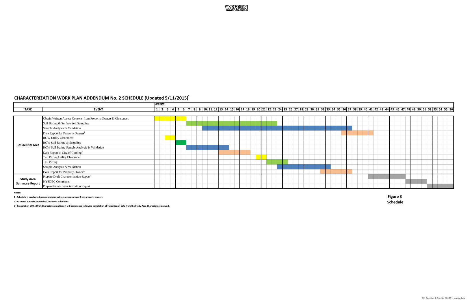
Schedule
The characterization activities described in this Work Plan Addendum 2 will be scheduled following receipt of NYSDEC’s approval of Work Plan Addendum 2. The

Study Area Characterization Work Plan Addendum Number 2 Additional Field Investigation Activities
Study Area, Corning, NY NYSDEC Project ID 851046 (continued)
15
anticipated project schedule is provided in Figure 3, attached to this Work Plan Addendum Number 2. Since this work will be performed as a supplemental scope of work to the Work Plan, the Study Area Characterization Report described in the Work Plan will be prepared following the completion of the additional work contained in this Work Plan Addendum Number 2.
John Sontag, Jr. Senior Project Manager

Study Area Characterization Work Plan Addendum Number 2 Additional Field Investigation Activities
Study Area, Corning, NY NYSDEC Project ID 851046 (continued)
16
ATTACHMENT A
Vegetable Garden Sampling
Soil samples will be collected from vegetable gardens that are present at properties to be sampled under Work Plan Addendum Number 2. At properties where there are multiple non-contiguous vegetable gardens, all of the garden areas will be combined and sampled as one garden. Samples will be collected using the following approach:
1. Number of samples to be collected per vegetable garden: a. One (1) composite sample for gardens up to 50 square feet in area b. Two (2) composite samples for gardens with 50 to 500 square feet in area c. Three (3) composite samples for gardens from over 500 to 2,000 square
feet in area d. For gardens over 2,000 square feet in area, the number of samples will be
agreed upon in the field with the NYSDEC representative present in the Study Area with email confirmation to the NYSDEC Project Manager.
2. Each composite sample will consist of subsamples, collected from 5-7 locations,
mixed together as one sample. a. Subsamples will be off-set approximately two feet from building
foundations, garden boundaries (especially those with pressure-treated wood), or highly trafficked areas.
3. Each subsample will be collected from a depth of 0 to 12 inches below the ground
surface excluding the ground cover if any.
4. Samples from the vegetable gardens will be analyzed for TAL metals plus mercury.
5. Field documentation to be collected during sampling will include a physical
description of garden (i.e., type of border around the garden, location relative to structures and ornaments on the property, etc.), a description of the soil conditions, types of crops grown, soil amendments used, use of fertilizers, pesticides, etc., and presence of soil from outside the Study Area.
6. Flower beds, raised bed gardens and potted plant gardens will not be sampled.

Table 1
Properties Above NYSDEC Residential SCOs
Residential Area Sampling
September 8, 2014 ‐ December 18, 2014
Study Area, Corning, NY
Residential Property
Code
One or More Surface
Soil Samples above
NYSDEC Residential
SCOs
Property Owner
Reported to NYSDEC
they Have Observed
Ash, Brick, and/or
Glass
Property Owner
Reported to WESTON
they Have Observed
Ash, Brick, and/or
Glass
WESTON Observed
Ash, Brick, and/or
Glass During Sampling
RES002 YES YES YES
RES006 YES
RES013 YES
RES014 YES
RES019 YES
RES021 YES
RES027 YES YES YES
RES034 YES YES
RES039 YES
RES049 YES
RES052 YES YES YES
RES055 YES
RES062 YES YES
RES074 YES
RES075 YES
RES080 YES
RES092 YES YES YES YES
RES095 YES
RES096 YES YES YES YES
RES103 YES
RES115 YES YES
RES123 YES
RES131 YES YES
RES138 YES YES
RES143 YES
RES154 YES
RES162 YES YES
RES164 YES
RES170 YES YES
RES179 YES YES YES
RES187 YES YES
RES200 YES YES
RES211 YES
RES212 YES
RES215 YES
RES221 YES YES YES
CNY_Prop_Summary_03‐25‐2015.xlsx May 11, 2015

Table 2
Additional Investigation Areas ‐ Northwest Corner of the Study Area
Residential Area Sampling
September 8, 2014 ‐ December 18, 2014
Study Area, Corning, NY
Residential Property
Code
One or More Surface
Soil Samples above
NYSDEC Residential
SCOs
Property Owner
Reported to NYSDEC
they Have Observed
Ash, Brick, and/or
Glass
Property Owner
Reported to WESTON
they Have Observed
Ash, Brick, and/or
Glass
WESTON Observed
Ash, Brick, and/or
Glass During Sampling
RES001 NO
RES004 Not Sampled
RES005 Not Sampled
RES056 NO
RES077 NO YES
RES078 Not Sampled
RES079 NO YES
RES083 NO
RES087 NO YES
RES090 NO
RES091 NO YES
RES097 NO
RES132 NO YES
CNY_Prop_Summary_03‐25‐2015.xlsx May 11, 2015
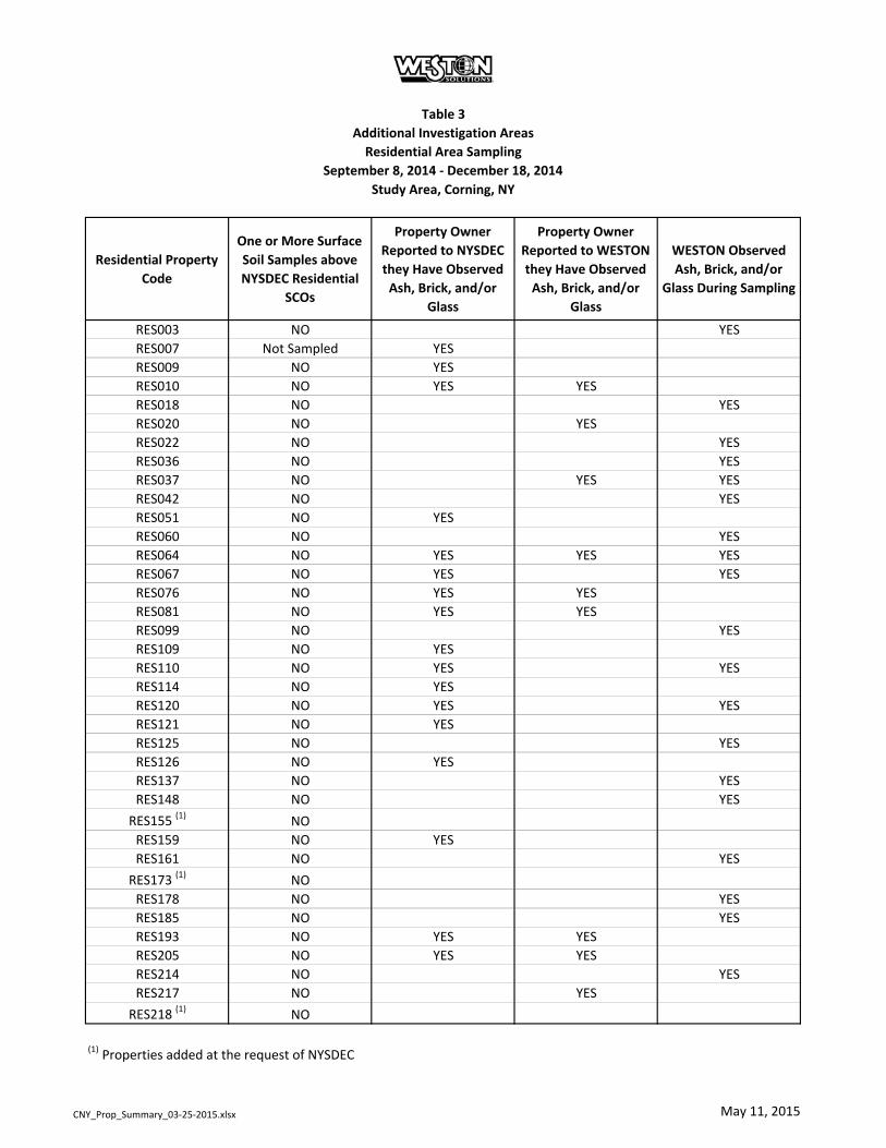
Table 3
Additional Investigation Areas
Residential Area Sampling
September 8, 2014 ‐ December 18, 2014
Study Area, Corning, NY
Residential Property
Code
One or More Surface
Soil Samples above
NYSDEC Residential
SCOs
Property Owner
Reported to NYSDEC
they Have Observed
Ash, Brick, and/or
Glass
Property Owner
Reported to WESTON
they Have Observed
Ash, Brick, and/or
Glass
WESTON Observed
Ash, Brick, and/or
Glass During Sampling
RES003 NO YES
RES007 Not Sampled YES
RES009 NO YES
RES010 NO YES YES
RES018 NO YES
RES020 NO YES
RES022 NO YES
RES036 NO YES
RES037 NO YES YES
RES042 NO YES
RES051 NO YES
RES060 NO YES
RES064 NO YES YES YES
RES067 NO YES YES
RES076 NO YES YES
RES081 NO YES YES
RES099 NO YES
RES109 NO YES
RES110 NO YES YES
RES114 NO YES
RES120 NO YES YES
RES121 NO YES
RES125 NO YES
RES126 NO YES
RES137 NO YES
RES148 NO YES
RES155 (1) NO
RES159 NO YES
RES161 NO YES
RES173 (1) NO
RES178 NO YES
RES185 NO YES
RES193 NO YES YES
RES205 NO YES YES
RES214 NO YES
RES217 NO YES
RES218 (1) NO
(1) Properties added at the request of NYSDEC
CNY_Prop_Summary_03‐25‐2015.xlsx May 11, 2015
!.
!.
!.
!.
!.
!.
!.
!.
!.
!.
!.
!.
!.
!.
!.
!.
!.
!.
!.
!.
!.
!.
!.
!.!.!.
!.!.!.
!. !.
!.!.
!.!.
!.
!.
!.
!.
!.
!.
!.
!.
Corning Boulevard
Pyrex S
treet
E. Pulteney Street
Ho
ug
hto
nC
i rcl e
!(!
!(!
!(!
!(!
!(!
!(!
!(! !(!
!(!
!(!
ROWSB021
ROWSB022
ROWSB002
ROWSB019
ROWSB013
ROWSB010
ROWSB005
ROWSB015
ROWSB012
ROWSB018
ROWSB024
ROWSB023
ROWSB020
ROWSB011
ROWSB017
ROWSB006
ROWSB007
ROWSB001
ROWSB004
ROWSB009
ROWSB016
ROWSB014
ROWSB025ROWSB026
ROWSB027
ROWSB029ROWSB030
ROWSB031 ROWSB032
ROWSB033ROWSB034
ROWSB035ROWSB036
ROWSB043
ROWSB042
ROWSB041
ROWSB040
ROWSB039
ROWSB038
ROWSB037
ROWSB003
ROWSB028ROWSB008
Figure 1Soil Borings
Residential Areas
5/11/2015± 0 40 80 120Meters
0 200 400Feet
NOTES: Base Imagery: ESRI, DigitalGlobe, GeoEye Mapping Service, 2011 Coordinate System: NAD 1983 State Plane New York Central Feet Datum: NAD83. Units: Feet
Souce File: Soil_Borings.MXD
Legend
Residential Area
Parcels
!. Soil Borings
!(! Proposed Soil Borings
Study AreaCorning NY
Study Area Location
Corning Boulevard
Pyrex S
treet
E. Pulteney Street
Ho
ug
hto
nC
i rcl e
!(!!(!
!(!
!(!
!(!
!(!
!(!
Figure 2Approximate Test Pit Locations
and Additional Soil BoringsResidential Areas
5/11/2015± 0 40 80 120Meters
0 200 400Feet
NOTES: Base Imagery: ESRI, DigitalGlobe, GeoEye Mapping Service, 2011 Coordinate System: NAD 1983 State Plane New York Central Feet Datum: NAD83. Units: Feet
Souce File: Approx_Test_pit.MXD
Legend
Residential Area
Parcels
Test Pit Areas
!(! Proposed Soil Borings
Study AreaCorning NY
Study Area Location
CHARACTERIZATION WORK PLAN ADDENDUM No. 2 SCHEDULE (Updated 5/11/2015)1
WEEKS
TASK EVENT 1 2 3 4 5 6 7 8 9 10 11 12 13 14 15 16 17 18 19 20 21 22 23 24 25 26 27 28 29 30 31 32 33 34 35 36 37 38 39 40 41 42 43 44 45 46 47 48 49 50 51 52 53 54 55 56
Obtain Written Access Consent from Property Owners & Clearances
Soil Boring & Surface Soil Sampling
Sample Analysis & Validation
Data Report for Property Owners2
ROW Utility Clearances
ROW Soil Boring & Sampling
ROW Soil Boring Sample Analysis & Validation
Data Report to City of Corning2
Test Pitting Utility Clearances
Test Pitting
Sample Analysis & Validation
Data Report for Property Owners2
Prepare Draft Characterization Report3
NYSDEC Comments
Prepare Final Characterization Report
Notes:
1 ‐ Schedule is predicated upon obtaining written access consent from property owners
2 ‐ Assumed 2 weeks for NYSDEC review of submittals.
3 ‐ Preparation of the Draft Characterization Report will commence following completion of validation of data from the Study Area Characterization work.
Study Area
Summary Report
Residential Area
Figure 3
Schedule
CNY_Addendum_2_Schedule_2015‐05‐11_Approved.xlsx
May 13, 2015
Michael Ford, P.E. Corning Incorporated HP-ME-03-83 Corning, New York 14831
Re: Study Area Characterization Work Plan Addendum Number 2 - Additional Field Investigation Activities; Study Area, Project No. 851046 Corning (C), Steuben (Co)
Dear Mr. Ford:
The New York State Department of Environmental Conservation (NYSDEC), in consultation with the New York State Department of Health (NYSDOH), has reviewed the Study Area Characterization Work Plan Addendum Number 2 - Additional Field Investigation Activities dated May 11, 2015. All previous comments have been adequately addressed and this document is hereby approved.
If you should have any questions regarding this letter, please contact me at (585) 226-5356 or [email protected].
Sincerely,
Gregory B. MacLean, P.E. Project Manager Division of Environmental Remediation
ec: M. Cruden, NYSDEC B. Conlon, NYSDEC B. Putzig, NYSDEC M. Doroski, NYSDOH J. Deming, NYSDOH Karen Douglas, Corning Incorporated Jean McCreary, Nixon Peabody John Sontag, Weston Solutions