Study area - majorprojects.planningportal.nsw.gov.au
16
Page 1 10 May 2021 Andrew Hollander Assistant Development Manager Corporate Property Woolworths Group Limited 1 Woolworths Way, Bella Vista NSW, 2153, Australia Dear Andrew, Re: 250-266 Victoria St, Wetherill Park: Aboriginal Heritage Assessment Woolworths Group limited (Woolworths) propose to develop a new distribution centre at 250-266 Victoria St, Wetherill Park. Artefact Heritage (Artefact) have been engaged by Woolworths to prepare an Aboriginal heritage assessment which has been developed to support a State Significant Development (SSD) application under the Environmental Planning and Assessment Act. Study area The study area is located at 250-266 Victoria Street, Wetherill Park (Lot 1/ DP 832281 and Lot 7/ DP 1015294), approximately 37 kilometres west of the Sydney CBD and 11 kilometres southwest of Parramatta. The study area is situated between Redfern Street to the north, and Victoria Street to the south. Land to the east and west of the study area contains existing industrial facilities. The study area is shown in Figure 1. The study area is currently used as a laydown area for a heavy vehicle transportation group (Lot 7 DP/ 1015294) and as an Austral bricks warehouse and storage facility (Lot 1/ DP 832281). The study area is located within the City of Fairfield Local Government Area (LGA), the County of Cumberland and is within the boundaries of the Deerubbin Local Aboriginal Land Council (LALC). Proposal Consent is sought for the construction and operation of a warehouse and distribution facility. The proposed warehouse and distribution facility would comprise storage and distribution of goods. The ground floor would contain the storage of produce and general storage and Level 1 would contain the storage of chilled and frozen goods. Both levels would include hardstand for loading bays for pick up and drop off of goods via rigid vehicles. Ancillary car parking has been provided on Site to facilitate operational phase of the proposed development. Ancillary offices, support space and staff amenities are provided at both ground floor and level 1 (see Figure 2). Aboriginal consultation A site visit was conducted with Steve Randall of the Deerubbin LALC. No archaeological or cultural values particular to the site were identified by the LALC.
Transcript of Study area - majorprojects.planningportal.nsw.gov.au

Page 1
10 May 2021
Andrew Hollander
Assistant Development Manager
Corporate Property
Woolworths Group Limited
1 Woolworths Way, Bella Vista NSW, 2153, Australia
Dear Andrew,
Re: 250-266 Victoria St, Wetherill Park: Aboriginal Heritage Assessment
Woolworths Group limited (Woolworths) propose to develop a new distribution centre at 250-266
Victoria St, Wetherill Park. Artefact Heritage (Artefact) have been engaged by Woolworths to
prepare an Aboriginal heritage assessment which has been developed to support a State Significant
Development (SSD) application under the Environmental Planning and Assessment Act.
Study area
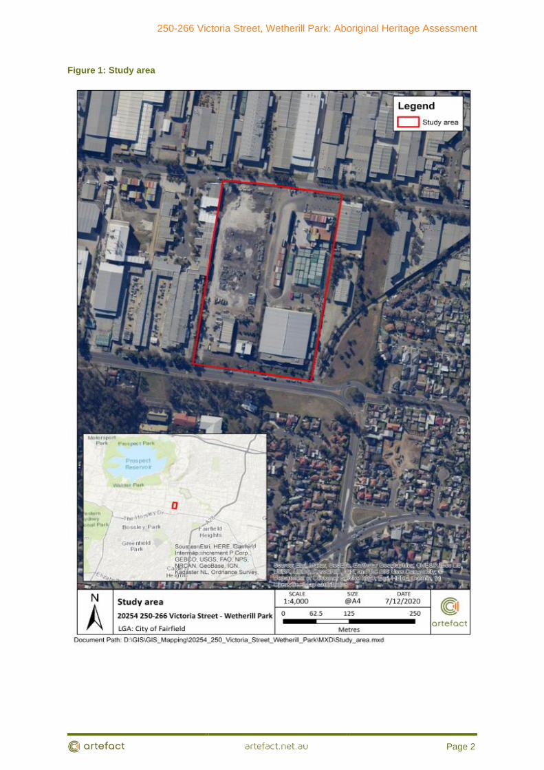
The study area is located at 250-266 Victoria Street, Wetherill Park (Lot 1/ DP 832281 and Lot 7/ DP
1015294), approximately 37 kilometres west of the Sydney CBD and 11 kilometres southwest of
Parramatta. The study area is situated between Redfern Street to the north, and Victoria Street to
the south. Land to the east and west of the study area contains existing industrial facilities. The
study area is shown in Figure 1.
The study area is currently used as a laydown area for a heavy vehicle transportation group (Lot 7
DP/ 1015294) and as an Austral bricks warehouse and storage facility (Lot 1/ DP 832281).
The study area is located within the City of Fairfield Local Government Area (LGA), the County of
Cumberland and is within the boundaries of the Deerubbin Local Aboriginal Land Council (LALC).
Proposal
Consent is sought for the construction and operation of a warehouse and distribution facility. The
proposed warehouse and distribution facility would comprise storage and distribution of goods. The
ground floor would contain the storage of produce and general storage and Level 1 would contain
the storage of chilled and frozen goods. Both levels would include hardstand for loading bays for
pick up and drop off of goods via rigid vehicles. Ancillary car parking has been provided on Site to
facilitate operational phase of the proposed development. Ancillary offices, support space and staff
amenities are provided at both ground floor and level 1 (see Figure 2).
Aboriginal consultation
A site visit was conducted with Steve Randall of the Deerubbin LALC. No archaeological or cultural
values particular to the site were identified by the LALC.
250-266 Victoria Street, Wetherill Park: Aboriginal Heritage Assessment
Page 2
Figure 1: Study area

250-266 Victoria Street, Wetherill Park: Aboriginal Heritage Assessment
Page 1
Figure 2: Proposal

250-266 Victoria Street, Wetherill Park: Aboriginal Heritage Assessment
Page 1
Legislative context
National Parks and Wildlife Act 1974
The National Parks & Wildlife Act 1974 (the NPW Act) provides statutory protection for all Aboriginal
‘objects’ (consisting of any material evidence of the Aboriginal occupation of NSW) and for
‘Aboriginal Places’ (areas of cultural significance to the Aboriginal community). A Section 90
Aboriginal Heritage Impact Permit (AHIP) is the only permit available to impact identified Aboriginal
objects and/or an identified Aboriginal place. An AHIP can only be issued by Heritage NSW. Under
an SSD approval an AHIP is not required if the SEARs are followed during the EIS assessment and
any conditions of approval are adhered to after determination.
Environmental Planning and Assessment Act 1979
The project will be determined as SSD under the EPA Act. SEARs for the project have been
received a per below.
15 Cultural Heritage and Aboriginal Cultural Heritage – including:
evidence that Aboriginal cultural heritage values that exist across the
development have been identified and documented in an Aboriginal Cultural
Heritage Assessment Report (ACHAR) for the proposed Council DA for the bulk
earthworks/enabling works on the site
evidence that consultation with Aboriginal people must be undertaken and
documented in ACHAR
a description of the impacts on Aboriginal cultural heritage values.
An Aboriginal heritage assessment was prepared for the bulk earthworks and referred to in the DA
conditions provided by Council. The DA conditions
Deerubbin LALC attended the site survey and did not identify and archaeological or cultural heritage
values.
It is noted that Artefact and the proponent met with Heritage NSW (Jackie Taylor) on 21 April 2021
where it was confirmed that the SSD did not require a full ACHAR as the bulk earthworks DA had
been previously approved by Council with supporting Aboriginal heritage assessment.
Background Context
Historical Context
Non-Aboriginal exploration in the region began shortly after the landing of the first fleet in 1788, with
Governor Philip leading a party up Prospect Hill in April that year. Prospect Hill became a significant
landmark for settlers and a reference point for early exploratory parties including Watkin Tench in his
journey west in 1789.
In 1791, Governor Philip made various land grants on the southern and eastern slopes of Prospect
Hill. The study area was originally part of a12,300 acre grant to the Orphan Institution by Governor

250-266 Victoria Street, Wetherill Park: Aboriginal Heritage Assessment
Page 2
King in 1803. In 1827 2,118 acres of this land near Prospect Creek was purchased by James
Chisholm.
By the 1850s with the construction of the Southern Railway line, land within the Fairfield LGA had
developed with small towns, timber operations, market gardens, vineyards and orchards. Settlement
within this area was also encouraged with the development and construction of the Prospect
Reservoir (MDCA 2017).
Aerial photography from 1965 shows that at this time the study area was utilised for market
gardening and had been completely cleared of native vegetation. At this time, a small first order
tributary of Prospect Creek was located directly east of the study area.
By 1975 further development had occurred in the land surrounding the study area including
additional land clearance and the canalisation of the watercourse to the east (Figure 3). By 1978, the
study area had transitioned into an industrial hard stand/ storage area (Figure 4).
Figure 3: 1965 historical aerial, study area approximated in red

250-266 Victoria Street, Wetherill Park: Aboriginal Heritage Assessment
Page 3
Figure 4: 1975 historical aerial, study area approximated in red
Figure 5: 1978 historical aerial, study area approximated in red
Environmental Context
The study area is located within the Cumberland Plain, a large low-lying and gently undulating
landform in the Sydney Basin. The formation of the basin began between 300 to 250 million years
ago when river deltas gradually replaced the ocean that had extended as far west as Lithgow
(Pickett & Alder 1997).
250-266 Victoria Street, Wetherill Park: Aboriginal Heritage Assessment
Page 4
The geology of the study area is characterised by the Triassic Wianamatta Liverpool Sub-Group.
The Liverpool Sub-Group comprises Bringelly Shale over Minchinbury Sandstone and Ashfield
Shale and consists of shale and some sandstone beds and outcrops. Local relief is between ten and
fifty metres with undulating slopes to below ten per cent (Bryan 1966).
The soils in the study area are within the Blacktown soil landscape, which typically consists of a
shallow duplex soil atop a clay base. The biomantle is characterised by a textured soil that is usually
less than thirty centimetres deep (Espade 2020a).
Localised soil investigation has identified that land within the vicinity of the study area has been
subject to substantial industrial disturbance with artefact bearing A horizon soils identified as heavily
truncated or completely removed (Espade 2020b, 2020c).
The closest current watercourse to the study area is Prospect Creek located approximately 650m to
the southwest. Historical aerials indicate that a first order tributary was formerly located immediately
east of the study area.
Previous documentary and archaeological research indicate that archaeological evidence is likely to
be found within certain landform contexts, largely as a result of the resources that were to be found
within certain landform contexts, largely as a result of the resources that were associated with these
landforms, or their suitability for long-term and/or repeated occupation. The due diligence guidelines
list five such landforms:
• Within 200m of waters.
• Within a sand dune system.
• On a ridge top. Ridge line, or headland.
• Within 200m below or above a cliff face.
• Within 20m of or in a cave, rock shelter, or a cave mouth.
Historically the study area was located immediately west of the first order tributary of Prospect
Creek.
Ethnohistorical Background
Prior to the appropriation of their land, the study area was the lands of the Cabrogal people (MDCA
2017). It is suggested that the Cabrogal people lands extended south to the Georges River and
north to the greater Prospect area (MDCA 2017). Colonisation of the Fairfield and Liverpool areas
resulted in the spreading of diseases, namely smallpox, which devastated not only the Cabrogal, but
most Aboriginal populations across greater Sydney.
The Cabrogal people, linguistically spoke Darug, which is the predominate Cumberland Plains
language group. Given their territory extended to the Georges River, it is likely that the Gabrogal
would have also they would have also spoke the Dharawal language (MDCA 2017).
Early historical accounts of Aboriginal people are inevitably subject to the writer’s bias; however,
they do provide valuable observations of Aboriginal customs and life during the early period of
European occupation. Language dialects varied across the Cumberland Plain, although early
Europeans recorded observations of interaction and mutual intelligibility between Darug speakers
from different regions. Captain Watkin Tench detailed an interaction between two Aboriginal men,
one from the coast and one from inland, and noted the range of variability between dialects. Tench
observed that though the men conversed on par and understood each other perfectly, many words
for common things bore no similarities, yet other words were only slightly different (Tench 1793:122).
250-266 Victoria Street, Wetherill Park: Aboriginal Heritage Assessment
Page 5
The existing archaeological record is limited to certain materials and objects that are able to
withstand degradation and decay. As a result, the most common type of Aboriginal objects
remaining in the archaeological record are stone artefacts, followed by bone and shell. The
investigation area is located within an area rich with resources.
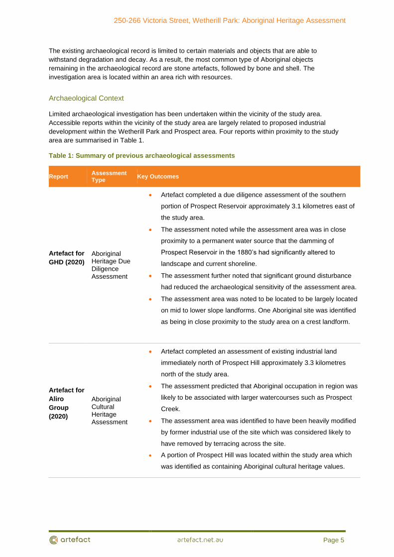
Archaeological Context
Limited archaeological investigation has been undertaken within the vicinity of the study area.
Accessible reports within the vicinity of the study area are largely related to proposed industrial
development within the Wetherill Park and Prospect area. Four reports within proximity to the study
area are summarised in Table 1.
Table 1: Summary of previous archaeological assessments
Report Assessment Type
Key Outcomes
Artefact for
GHD (2020)
Aboriginal Heritage Due Diligence Assessment
• Artefact completed a due diligence assessment of the southern
portion of Prospect Reservoir approximately 3.1 kilometres east of
the study area.
• The assessment noted while the assessment area was in close
proximity to a permanent water source that the damming of
Prospect Reservoir in the 1880’s had significantly altered to
landscape and current shoreline.
• The assessment further noted that significant ground disturbance
had reduced the archaeological sensitivity of the assessment area.
• The assessment area was noted to be located to be largely located
on mid to lower slope landforms. One Aboriginal site was identified
as being in close proximity to the study area on a crest landform.
Artefact for
Aliro
Group
(2020)
Aboriginal Cultural Heritage Assessment
• Artefact completed an assessment of existing industrial land
immediately north of Prospect Hill approximately 3.3 kilometres
north of the study area.
• The assessment predicted that Aboriginal occupation in region was
likely to be associated with larger watercourses such as Prospect
Creek.
• The assessment area was identified to have been heavily modified
by former industrial use of the site which was considered likely to
have removed by terracing across the site.
• A portion of Prospect Hill was located within the study area which
was identified as containing Aboriginal cultural heritage values.

250-266 Victoria Street, Wetherill Park: Aboriginal Heritage Assessment
Page 6
Report Assessment Type
Key Outcomes
Biosis for Charter Hall (2020).
Aboriginal archaeological advice
• Biosis provided an Aboriginal archaeological advice letter for
several properties located on Cowpasture Road located 3.3
kilometres to the west of the study area.
• Biosis identified that Aboriginal sites within the region would be
focused in close proximity to water, within natural rises in the
landscape or in close proximity to resource gathering areas.
• Biosis identified that the distance of the site from a permanent
watercourse would have made the study area unsuitable for long
term occupation. Shallow top soils located within crest landforms
which had been subject to further disturbance were unlikely to
preserve Aboriginal sites.
MDCA for Fairfield City Council (2017)
Aboriginal Heritage Study
• MDCA completed an Aboriginal heritage study of the Fairfield LGA.
The assessment focused on the identification, assessment and
recording of culturally significant places to Aboriginal people.
• This report collated known records from the AHIMS register,
Australian Business Museum and other archaeological heritage
reports.
• The majority of these sites within the LGA were identified as being
located within the Western Sydney Parklands or the Sydney Water
lands. This was largely associated with limited development in
these regions and the proximity to watercourses.
• The study area was not identified as having archaeological
potential.
• The assessment noted that substantial disturbance had occurred
within the LGA at a time when Aboriginal sites were not recorded.
• The assessment noted that many Aboriginal archaeological sites as
well as cultural associations to Aboriginal places have been lost
within the Fairfield LGA.
Aboriginal Heritage Information Management System
Heritage NSW maintains the Aboriginal Heritage Information Management System (AHIMS)
database, a register of Aboriginal sites that have been recorded in New South Wales. A search of
the AHIMS database was undertaken on the 07 December 2020 for sites registered within the
following coordinates:

250-266 Victoria Street, Wetherill Park: Aboriginal Heritage Assessment
Page 7
GDA 1994 MGA 56 305136 – 309310E
6250738 – 6255082N
Buffer 0 metres
Number of sites 22
AHIMS Search ID 555614
No recorded AHIMS sites are located within 200m of the study area. The majority of recorded sites
within the AHIMS search area are comprised of artefacts (n=21, 95.4%) with one Potential
Archaeological Deposit (PAD) (n=1, 4.5%) also recorded. AHIMS sites within the search area are
focused along existing waterways including Prospect Creek and Orphan School Creek (Figure 6 and
Figure 7).

250-266 Victoria Street, Wetherill Park: Aboriginal Heritage Assessment
Page 8
Figure 6: Extensive AHIMS search

250-266 Victoria Street, Wetherill Park: Aboriginal Heritage Assessment
Page 9
Figure 7: AHIMS sites within the vicinity of the study area

250-266 Victoria Street, Wetherill Park: Aboriginal Heritage Assessment
Page 10
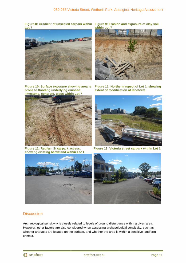
Site inspection results
A site inspection was undertaken on foot by Alyce Haast (Senior Heritage Consultant, Artefact
Heritage) and Brye Marshall (Graduate Heritage Consultant, Artefact Heritage) on Tuesday 08
December 2020. A large proportion of the ground surface was obscured by existing development,
which includes areas of concrete hardstand or open exposed compacted gravel and/or sandstone
fill. The site inspection focused on understanding the extent of landform modification across the
study area.
Lot 1/DP 83228 was located in the eastern portion of the study area and was comprised of a
distribution centre for the loading and unloading of concrete blocks and steel framing. The landform
within Lot 1 was comprised of modified flat and slope landforms which included multiple artificial
terrace layers across the lot. Visibility was low within Lot 1 with a large proportion of the lot
obscured by concrete and bitumen.
Lot 7/ DP 1015294 was located in the western portion of the study area and was largely utilised as a
parking and laydown area for heavy vehicles. Lot 7/ DP 1015294 has been subject to a lower level
of modification then Lot 1 with the majority of the terrace landform comprised of a gentle slope
reminiscent of the former landform across the study area. As seen with Lot 1, Lot 7 has been
subject to substantial modification associated with landform modification, concrete driveways and
the presence of imported fills across the study area.
Surface visibility across both lots of the study area was less than 10%.
Vegetation was largely limited to the boundaries which were comprised of a combination of recent
planting including exotic and native species. No old growth trees were observed.
No Aboriginal artefacts were observed during the site inspection. No areas of archaeological
sensitivity were identified within the study area.
An additional site inspection was undertaken by Brye Marshall (Heritage Consultant, Artefact) and
Steve Randall (Deerubbin LALC) on 28 April 2021.
250-266 Victoria Street, Wetherill Park: Aboriginal Heritage Assessment
Page 11
Figure 8: Gradient of unsealed carpark within Lot 7
Figure 9: Erosion and exposure of clay soil within Lot 7
Figure 10: Surface exposure showing area is prone to flooding underlying crushed limestone, concrete, glass within Lot 7
Figure 11: Northern aspect of Lot 1, showing extent of modification of landform
Figure 12: Redfern St carpark access, showing existing hardstand within Lot 1
Figure 13: Victoria street carpark within Lot 1
Discussion
Archaeological sensitivity is closely related to levels of ground disturbance within a given area.
However, other factors are also considered when assessing archaeological sensitivity, such as
whether artefacts are located on the surface, and whether the area is within a sensitive landform
context.

250-266 Victoria Street, Wetherill Park: Aboriginal Heritage Assessment
Page 12
Although the study area was once located within 200m of a watercourse, this watercourse is
comprised of a low order tributary of Prospect Creek which is unlikely to have formed a focus of
Aboriginal occupation when compared to higher order watercourses in close proximity to the study
area. Prior to historic landform modification the study area would have been comprised of a
moderately sloped landform which is not identified as a sensitive landform in accordance with the
Due Diligence Code of Practice.
Background research and the results of the site survey have indicated that the study area has been
subject to substantial landform modification associated with the terracing of the study area for
industrial use. Exposed soil profiles within the study area indicated that the majority of the study area
had been truncated to the underlying clay B horizon. Based on this it is considered that landform
modification would have removed any Aboriginal archaeological deposits which may have otherwise
been present within the study area.
The study area has been assessed to have nil- low Aboriginal archaeological potential.
Recommendations
The following recommendations regarding Aboriginal heritage are based on consideration of:
• Statutory requirements under the National Parks and Wildlife Act 1974.
• The results of background research, site survey and assessment.
• The likely impacts of the proposed development.
It was found that:
• No previously recorded Aboriginal sites are located within the study area.
• No previously unrecorded Aboriginal sites or areas of archaeological sensitivity were
identified within the study area during the site inspection.
• The study area has nil-low Aboriginal archaeological potential.
• A bulk earthworks DA has previously been approved for the site which also found that there
would be no impacts to Aboriginal heritage values.
The following recommendations are made:
• No Aboriginal heritage constraints have been identified for the proposed works and works
may proceed with caution.
• An ACHAR is not required under the SSD in accordance with the findings of this report an
the advice of Heritage NSW.
• If unforeseen Aboriginal objects are uncovered during construction, work should cease, and
an archaeologist, Heritage NSW and Deerubbin LALC should be contacted to advise on the
find.
• If changes are made to the project that may result in impacts to areas not assessed in this
report, additional assessment may be required.

250-266 Victoria Street, Wetherill Park: Aboriginal Heritage Assessment
Page 13
References
Artefact, 2020, Aboriginal Heritage Due Diligence Assessment, Prospect Water Filtration Plant.
Report prepared for GHD
Artefact 2020, Aboriginal Cultural Heritage Assessment Report, Prospect Logistics Estate. Report
prepared for Aliro Group.
Attenbrow, V, 2010 Sydney’s Aboriginal Past: Investigating the archaeological and historical records.
UNSW Press
Bannerman, S. M. & Hazelton, P.A. 1990. Soil Landscapes of Penrith 1:100,000 Sheet. Soil
Conservation Service of New South Wales. Sydney.
Biosis 2020, Aboriginal Heritage Advice Report, Horsley Business Park Stage 2 State Significant
Development Application. Report prepare for Charter Hall.
eSPADe 1998. Lat update 13 June 1988. Accessed 10/12/2020.
https://www.environment.nsw.gov.au/espade2webapp/report/profile/7183
Mary Dallas Consulting Archaeologists 2017, Fairfield City Council Aboriginal Heritage Study. Report
prepared for Fairfield City Council.
Matthews, R.H. and Everitt, M.M. (1900). "The organisation, language and initiation ceremonies of
the Aborigines of the south-east coast of N.S. Wales." Journal and Proceedings of the Royal Society
of NSW 34: 262-281.
Tench, Watkin (1789). Sydney's First Four Years: Being a reprint of 'A narrative of the expedition to
Botany Bay' and 'A complete account of the Settlement at Port Jackson', Angus & Robertson.
Wetherill Park. Accessed 09/12/2020
https://en.wikipedia.org/wiki/Wetherill_Park,_New_South_Wales