Appendix 1 A - majorprojects.planningportal.nsw.gov.au
104
Appendix 1 A Regulatory Requirements Appendix Section Description 1A SEARs 1B Agency Input into Key Assessment Issues 1C Guidelines for preparing Assessment Documentation relevant to the EPBC 1999 Act 1D Existing Consent 1E Community Submission Brandy Hill Expansion Project Environmental Impact Statement
Transcript of Appendix 1 A - majorprojects.planningportal.nsw.gov.au

Appendix 1 A
Regulatory Requirements
Appendix Section Description
1A SEARs
1B Agency Input into Key Assessment Issues
1C Guidelines for preparing Assessment Documentation relevant to the EPBC 1999 Act
1D Existing Consent
1E Community Submission
Brandy Hill Expansion Project
Environmental Impact Statement

Appendix 1A
SEARs
Brandy Hill Expansion Project
Environmental Impact Statement

Director General’s Environmental Assessment Requirements Section 78A (8A) of the Environmental Planning and Assessment Act 1979 State Significant Development Application Number SSD 5899
Development Brandy Hill Quarry Expansion Project, which includes: • expanding the existing quarry to extract and process up to 1.5 million
tonnes of hard rock material a year for 30 years; • use of blasting (8 am to 5 pm weekdays); • constructing and operating additional infrastructure including a concrete
batching plant (15,000 m3 per year), mobile pug mill and pre-coat plant; • 24 hour operations, sales and despatch; • transporting quarry products off-site and receiving 20,000 tonnes of
concrete waste for recycling via public roads; and • rehabilitating the site.
Location Approximately 12 km north-west of Raymond Terrace
Applicant Hanson Construction Materials Pty Ltd
Date of Issue 9 July 2015 General Requirements The Environmental Impact Statement (EIS) for the development must meet the
form and content requirements in clauses 6 and 7 of Schedule 2 of the Environmental Planning and Assessment Regulation 2000. In addition, the EIS must include: • a detailed description of the development, including:
− need for the proposed development; − alternatives considered; − likely components and staging of the development - including
construction, operational stage/s and rehabilitation; and − plans of any proposed building works; − the likely interactions between the development and any other existing,
approved or proposed extractive industry development in the vicinity of the site (such as the Martins Creek Quarry);
• consideration of all relevant environmental planning instruments, including identification and justification of any inconsistencies with these instruments;
• a risk assessment of the potential environmental impacts of the development, identifying the key issues for further assessment;
• detailed assessment of the key issues specified below, and any other significant issues identified in the risk assessment, which includes: − a description of the existing environment, using sufficient baseline data; − an assessment of the potential impacts of all stages of the
development, including any cumulative impacts, taking into consideration relevant guidelines, policies, plans and statutes; and
− a description of the measures that would be implemented to avoid, minimise and if necessary, offset the potential impacts of the development, including proposals for adaptive management and/or contingency plans to manage any significant risks to the environment; and
• a statement of commitments, outlining all the proposed environmental management and monitoring measures included in the EIS.
The EIS must be accompanied by a report from a qualified quantity surveyor providing: • a detailed calculation of the capital investment value (CIV) (as defined in
clause 3 of the Environmental Planning and Assessment Regulation 2000) of the proposal, including details of all the assumptions and components from which the CIV calculation is derived;
• a close estimate of the jobs that will be created by the development during
the construction and operational phases of the development; and • certification that the information provided is accurate at the date of
preparation.
Key Issues
The EIS must address the following specific issues: • Land Resources - including a detailed assessment of the potential impacts
on: - soils and land capability; - landforms and topography, including rock formations, steep slopes,
land slippage, etc; and - land use, including agricultural use; - extractive material resources, including assessment of the size and
quality of the resource and description of the methods used to assess the resource and its suitability for the intended applications;
• Biodiversity – including: - accurate estimates of proposed vegetation clearing and impacts on
regionally significant remnant vegetation, or vegetation corridors; - a detailed assessment of potential impacts of the development on any
terrestrial or aquatic threatened species or populations and their habitats, endangered ecological communities listed under State or Commonwealth threatened species legislation;
- a detailed assessment of potential impacts of the development on any groundwater dependent ecosystems; and
- a detailed description of the measures that would be implemented to avoid, reduce or mitigate impacts on biodiversity, including an appropriate biodiversity offset strategy;
• Traffic & Transport – including: - accurate predictions of the road traffic generated by the construction
and operation of the development, including a description of the types of vehicles likely to be used for the transportation of quarry products, the public roads in the Dungog Shire, Maitland City and Port Stephens LGAs likely to be so used and the times during which those roads would be used;
- an assessment of potential traffic impacts on the safety and efficiency of the road network; and
- a detailed description of the measures that would be implemented to maintain and/or improve the capacity, efficiency and safety of the road networks in the surrounding area over the life of the development;
• Noise – including a quantitative assessment of potential: - construction, operational and off-site transport noise impacts; - reasonable and feasible mitigation measures, including evidence that
there are no such measures available other than those proposed; and - monitoring and management measures, in particular real-time and
attended noise monitoring; • Blasting – including proposed hours, frequency, methods and impacts; • Air Quality – including a quantitative assessment of potential:
- construction and operational impacts, with a particular focus on dust emissions including PM2.5 and PM10;
- dust generation from blasting and processing, as well as diesel emissions;
- reasonable and feasible mitigation measures to minimise dust and diesel emissions, including evidence that there are no such measures available other than those proposed; and
- monitoring and management measures, in particular real-time air quality monitoring;
• Heritage – including: - an Aboriginal cultural heritage assessment (including both cultural and
archaeological significance) which must: o demonstrate effective consultation with Aboriginal communities in
determining and assessing impacts, and developing and selecting mitigation options and measures;
o outline any proposed impact mitigation and management measures (including an evaluation of the effectiveness and reliability of the measures); and
- a historic heritage assessment (including archaeology) which must:

o include a statement of heritage impact (including significance assessment) for any State significant or locally significant historic heritage items; and,
o outline any proposed mitigation and management measures (including an evaluation of the effectiveness and reliability of the measures);
• Water Resources - including: - a detailed assessment of the potential impacts of the development on:
o the quantity and quality of regional water supplies; o regional water supply infrastructure; and o affected licensed water users and basic landholder rights (including
downstream water users); - a detailed site water balance, including a description of site water
demands, water disposal methods (inclusive of volume and frequency of any water discharges), water supply infrastructure and water storage structures;
- an assessment of proposed water discharge quantities and quality/ies against receiving water quality and flow objectives;
- identification of any licensing requirements or other approvals under the Water Act 1912 and/or Water Management Act 2000;
- demonstration that water for the construction and operation of the development can be obtained from an appropriately authorised and reliable supply in accordance with the operating rules of any relevant Water Sharing Plan (WSP);
- a description of the measures proposed to ensure the development can operate in accordance with the requirements of any relevant WSP or water source embargo; and
- a detailed description of the proposed water management system (including sewage), water monitoring program and other measures to mitigate surface and groundwater impacts;
• Waste – including: - accurate estimates of the quantity and nature of the potential waste
streams of the development; including any leachate and acid-generating potential;
- a waste disposal strategy, including any leachate; - details of the importation of materials onto the site; and - a description of measures that would be implemented to minimise
production of other waste, and ensure that that waste is appropriately managed;
• Greenhouse Gases – including: - a quantitative assessment of potential Scope 1, 2 and 3 greenhouse
gas emissions; - a qualitative assessment of the potential impacts of these emissions on
the environment; and - an assessment of reasonable and feasible measures to minimise
greenhouse gas emissions and ensure energy efficiency; • Visual – including:
- a detailed assessment of the: o changing landforms on site during the various stages of the
development; and o potential visual impacts of the development on private landowners
in the surrounding area as well as key vantage points in the public domain;
- a detailed description of the measures that would be implemented to minimise the potential visual impacts of the development;
• Hazards – paying particular attention to public safety, including bushfires; • Social & Economic – including:
- an assessment of potential impacts on local and regional communities, including impacts on social amenity;
- a detailed description of the measures that would be implemented to minimise the adverse social and economic impacts of the development, including any infrastructure improvements, or contributions and/or voluntary planning agreement or similar mechanism; and
- a detailed assessment of the costs and benefits of the development as

a whole, and whether it would result in a net benefit for the NSW community;
• Rehabilitation – including the proposed rehabilitation strategy for the site having regard to the key principles in the Strategic Framework for Mine Closure, including: - rehabilitation objectives, methodology, monitoring programs,
performance standards and proposed completion criteria; - nominated final land use, having regard to any relevant strategic land
use planning or resource management plans or policies; and - the potential for integrating this strategy with any other rehabilitation
and/or offset strategies in the region.
Plans and Documents The EIS must include all relevant plans, architectural drawings, diagrams and relevant documentation required under Schedule 1 of the Environmental Planning and Assessment Regulation 2000. These documents should be included as part of the EIS rather than as separate documents.
Consultation During the preparation of the EIS, you must consult with relevant local, State and Commonwealth Government authorities, service providers, Aboriginal stakeholders, community groups and affected landowners. In particular you must consult with the: • Commonwealth Department of Environment • Office of Environment and Heritage (including the Heritage Branch); • Environment Protection Authority; • Division of Resources and Energy within the Department of Trade and
Investment, Regional Infrastructure and Services; • Department of Primary Industries (including the NSW Office of Water, NSW
Forestry, Agriculture and Fisheries sections, and Crown Lands division; • Roads and Maritime Services; • Hunter Local Land Services; • Dungog Shire Council; • Maitland City Council; • Port Stephens Council; and • community groups including, but not limited to: Bolwarra Heights
Community Group, Brandy Hill and Seaham Action Committee and the Voice of Wallalong and Woodville.
The EIS must: • describe the consultation process used and demonstrate that effective
consultation has occurred; • describe the issues raised by public authorities, service providers,
community groups and landowners; • identify where the design of the development has been amended in
response to issues raised; and • otherwise demonstrate that issues raised have been appropriately
addressed in the assessment.
Further consultation after 2 years
If you do not lodge a DA and an EIS for the development within 2 years of the issue date of these DGRs, you must consult further with the Director-General in relation to the requirements for lodgement.
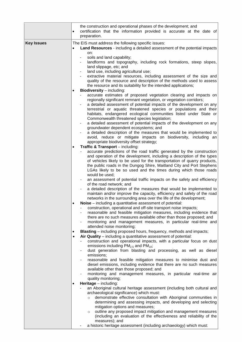
References The assessment of the key issues listed above must take into account relevant guidelines, policies, and plans as identified. While not exhaustive, Attachment 1 contains a list of some of the guidelines, policies, and plans that may be relevant to the environmental assessment of this development.

ATTACHMENT 1 Technical and Policy Guidelines
The following guidelines may assist in the preparation of the Environmental Impact Statement. This list is not exhaustive and not all of these guidelines may be relevant to your proposal. Many of these documents can be found on the following websites: http://www.planning.nsw.gov.au http://www.bookshop.nsw.gov.au http://www.publications.gov.au
Policies, Guidelines & Plans
Risk Assessment
AS/NZS 4360:2004 Risk Management (Standards Australia) HB 203: 203:2006 Environmental Risk Management – Principles & Process (Standards Australia)
Land Resources
Agricultural Impact Assessment Guidelines 2012 (DP&I)
Agfact AC25: Agricultural Land Classification (NSW Agriculture)
Australian and New Zealand Guidelines for the Assessment and Management of Contaminated Sites (ANZECC)
Agricultural Issues for Extractive Industries (NSW Department of Trade and Investment, Regional Infrastructure and Services)
Soil and Landscape Issues in Environmental Impact Assessment (DLWC)
Biodiversity
Threatened Species Survey and Assessment Guidelines: Field Survey Methods for Fauna – Amphibians (DECCW 2009) Threatened Biodiversity Survey and Assessment: Guidelines for Developments and Activities – Working Draft (DECC 2004) Guidelines for Threatened Species Assessment (DoP 2005) BioBanking Assessment Methodology and Credit Calculator Operational Manual (DECCW 2011) The Threatened Species Assessment Guideline – The Assessment of Significance (DECC 2007) NSW State Groundwater Dependent Ecosystem Policy (DLWC) Policy & Guidelines - Aquatic Habitat Management and Fish Conservation (NSW Fisheries) State Environmental Planning Policy No. 44 – Koala Habitat Protection
Principles for the Use of Biodiversity Offsets in NSW (OEH)
Significant impact guidelines 1.1 – Matters of National Environmental Significance (Commonwealth Department of Environment 2013)
Traffic & Transport Guide to Traffic Generating Development (RTA) Road Design Guide (RTA) Noise & Blasting NSW Industrial Noise Policy (DECC)
Environmental Noise Management – Assessing Vibration: a technical guide 2006 (DEC)
NSW Road Noise Policy 2011 (DECCW)
Technical basis for guidelines to minimise annoyance due to blasting overpressure and ground vibration (ANZECC)
Environmental Criteria for Road Traffic Noise (EPA) Air Quality
Protection of the Environment Operations (Clean Air) Regulation 2002 Approved Methods for the Modelling and Assessment of Air Pollutants in NSW 2005 (DEC)

Approved Methods for the Sampling and Analysis of Air Pollutants in NSW (DEC)
Guidelines from the USEPA, the California EPA Office of Environmental Health and EPA Victoria relating to respirable crystalline silica
Heritage
Aboriginal Draft Guidelines for Aboriginal Cultural Heritage Impact Assessment and Community Consultation (DEC 2005) The Burra Charter (The Australia ICOMOS charter for places of cultural significance)
Aboriginal Cultural Heritage Consultation Requirements for Proponents 2010 (OEH)
Code of Practice for Archaeological Investigations of Objects in New South Wales 2010 (OEH)
Historic NSW Heritage Manual (NSW Heritage Office) The Burra Charter (The Australia ICOMOS charter for places of cultural significance)
Water Resources
Surface Water
NSW Water Management Act 2000 National Water Quality Management Strategy: Australian Guidelines for Fresh and Marine Water Quality (ANZECC/ARMCANZ) National Water Quality Management Strategy: Australian Guidelines for Water Quality Monitoring and Reporting (ANZECC/ARMCANZ) National Water Quality Management Strategy: Guidelines for Sewerage Systems – Effluent Management (ARMCANZ/ANZECC) National Water Quality Management Strategy: Guidelines for Sewerage Systems – Use of Reclaimed Water (ARMCANZ/ANZECC) Using the ANZECC Guideline and Water Quality Objectives in NSW (DEC) State Water Management Outcomes Plan Water Sharing Plan for the Hunter Unregulated and Alluvial Water Sources 2009 NSW Government Water Quality and River Flow Objectives (DECC) Approved Methods for the Sampling and Analysis of Water Pollutants in NSW (DEC) Managing Urban Stormwater: Soils & Construction (Landcom) and associated Volume 2E: Mines and Quarries. Managing Urban Stormwater: Treatment Techniques (DECC) Managing Urban Stormwater: Source Control (DECC) Floodplain Development Manual (DIPNR) Floodplain Risk Management Guideline (DECC) A Rehabilitation Manual for Australian Streams (LWRRDC and CRCCH) Technical Guidelines: Bunding & Spill Management (DECC) Environmental Guidelines: Use of Effluent by Irrigation (DECC)
Groundwater
NSW Water Management Act 2000 NSW Water Act 1912 Office of Water Guidelines for Controlled Activities (2012) National Water Quality Management Strategy Guidelines for Groundwater Protection in Australia (ARMCANZ/ANZECC) NSW State Groundwater Policy Framework Document (DLWC, 1997) NSW State Groundwater Quality Protection Policy (DLWC, 1998) NSW State Groundwater Quantity Management Policy (DLWC, 1998) Guidelines for the Assessment & Management of Groundwater Contamination (DECC, 2007) Any relevant Water Sharing Plan for groundwater and surface water resources
NSW Aquifer Interference Policy (2012)
Waste
Waste Classification Guidelines (EPA)
Greenhouse Gases
National Greenhouse Accounts Factors (Australian Department of Climate Change (DCC))
Guidelines for Energy Savings Action Plans (DEUS)
Hazards
State Environmental Planning Policy No. 33 – Hazardous and Offensive Development

Hazardous and Offensive Development Application Guidelines - Applying SEPP 33
Hazardous Industry Planning Advisory Paper No. 6 – Guidelines for Hazard Analysis
Socio-Economic
Draft Economic Evaluation in Environmental Impact Assessment (DoP)
Techniques for Effective Social Impact Assessment: A Practical Guide (Office of Social Policy, NSW Government Social Policy Directorate)
Rehabilitation
Mine Rehabilitation – Leading Practice Sustainable Development Program for the Mining Industry (Commonwealth of Australia)
Mine Closure and Completion – Leading Practice Sustainable Development Program for the Mining Industry (Commonwealth of Australia)
Strategic Framework for Mine Closure (ANZMEC-MCA)

ATTACHMENT 2 Agency Input into Key Assessment Issues

ATTACHMENT 3
Community Group Submissions

ATTACHMENT 4 Commonwealth Department of Environment assessment requirements

Appendix 1 B
Agency Input into Key Assessment Issues
Brandy Hill Expansion Project
Environmental Impact Statement


Appendix 1 C
Guidelines for preparing Assessment Documentation relevant to the Environment Protection and Biodiversity Conservation
Act 1999 (EPBC Act)
Brandy Hill Expansion Project
Environmental Impact Statement

Guidelines for preparing Assessment Documentation relevant to the Environment Protection and Biodiversity Conservation Act 1999 (EPBC Act)
These Guidelines are intended to inform the development of Assessment Documentation for projects assessed under an assessment bilateral agreement. If a separate chapter is not provided in the Assessment Documentation, the Table at Attachment 1 detailing where the information is located must be completed.
References:
• Environment Protect and Biodiversity Conservation Act 1999 - section 51-55, section 96A(3)(a)(b), 101A(3)(a)(b), section 136, section 527E;
• Environment Protect and Biodiversity Conservation Regulations 2000 - Division 3.2, 3.02(a)(b)(ii)(iii), Division 5.2, Schedule 4;
• Bilateral Agreements - Item 18.1, Item 18.5, Schedule 1; and • Policy - Environment Protect and Biodiversity Conservation Act 1999 Environmental Offsets
Policy October 2012 1 BACKGROUND AND DESCRIPTION OF THE ACTION
The Assessment Documentation must provide background to the action and describe in detail all components of the action for example (but not limited to), the construction, operation and (if relevant) decommissioning components of the action. This must include the precise location of all works to be undertaken (including associated offsite works and infrastructure), structures to be built or elements of the action that may have impacts on matters of national environmental significance (MNES).
The description of the action must also include details on how the works are to be undertaken (including stages of development and their timing) and design parameters for those aspects of the structures or elements of the action that may have relevant impacts.
The Assessment Documentation must include how the action relates to any other actions (of which the proponent should reasonably be aware) that have been, or are being, taken or that have been approved in the region affected by the action.
The Assessment Documentation must also provide details on the current status of the action, alternatives to the action, as well as the consequences of not proceeding with the action.
2 THE ENVIRONMENT INCLUDING MNES
The Assessment Documentation must include a description of the environment and management practices of the proposal site and the surrounding areas and other areas that may be affected by the action. Include all relevant MNES protected by controlling provisions of Part 3 of the EPBC Act (see Attachment 2 for MNES specific to the project):
(a) A description of the World Heritage values of the World Heritage property relevant to the action.
a. Including Outstanding Universal Value, relevant plans

(b) A description of the National Heritage values of the National Heritage Place relevant to the action.
a. Including any relevant plans
(c) A description of the ecological character of the Ramsar Wetland relevant to the action.
a. Including any relevant plans
(d) Listed threatened species and communities (including suitable habitat) that are or are likely to be present in the vicinity of the site, including the following details:
i. Details of the scope, timing/effort (survey season/s) and methodology for studies or surveys used to provide information on the listed species/community/habitat at the site (and in areas that may be impacted by the project). Include details of:
o best practice survey guidelines are applied; and
o how they are consistent with (or a justification for divergence from) published Australian Government guidelines and policy statements.
ii. Include any relevant plans/agreements
(e) Listed migratory species (including suitable habitat) that are or are likely to be present in the vicinity of the site, including the following details:
i. Details of the scope, timing/effort (survey season/s) and methodology for studies or surveys used to provide information on the listed species/habitat at the site (and in areas that may be impacted by the project). Include details of:
a. best practice survey guidelines are applied;
b. how these are consistent with (or a justification for divergence from) published Australian Government guidelines and policy statements.
ii. Include any relevant plans/agreements
(f) A description of the environment relevant to the nuclear action.
(g) A description of the Great Barrier Reef Marine Park environment relevant to the action.
a. Including Outstanding Universal Value
(h) A description of the water resource environment relevant to the coal seam gas development or large coal mining development.
a. Refer to the Independent Expert Scientific Committee’s (IESC) Information Guidelines for Proposals Relating to the Development of Coal Seam Gas and Large Coal Mines where there is a Significant Impact on Water Resources, available at http://www.iesc.environment.gov.au/publications/information-guidelines-independent-expert-scientific-committee-advice-coal-seam-gas
b. Note: Advice will be requested from the IESC in regards to the proposal.

(i) A description of the environment relevant for part of the Commonwealth Marine (for actions outside the Commonwealth marine area that may impact the environment in the Commonwealth marine area).
a. Note: whole of the environment must be considered –refer to the Significant Impact Guidelines 1.2 – Actions on, or impacting upon, Commonwealth land and Actions by Commonwealth Agencies.
(j) A description of the environment relevant for Commonwealth Land (for actions outside Commonwealth Land that may impact on the environment on Commonwealth Land).
a. Note: whole of the environment must be considered –refer to the Significant Impact Guidelines 1.2 – Actions on, or impacting upon, Commonwealth land and Actions by Commonwealth Agencies.
3 IMPACTS
(a) The Assessment Documentation must include a description of all of the relevant impacts of the action on MNES (identified in Section 2). Impacts during the construction, operational and (if relevant) the decommissioning phases of the project must be addressed, and the following information provided:
i. a description of the relevant impacts of the action;
ii. a detailed analysis of the nature and extent of the likely direct, indirect and consequential impacts relevant to MNES, including likely short-term and long-term impacts – refer to the Significant Impact Guidelines 1.1 - Matters of National Environmental Significance for guidance on the various types of impact that need to be considered;
iii. a statement whether any relevant impacts are likely to be unknown, unpredictable or irreversible;
iv. any technical data and other information used or needed to make a detailed assessment of the relevant impacts;
v. an explanation of how Indigenous stakeholders’ views of the action’s impacts to biodiversity and cultural heritage have been sought and considered in the assessment. Including where relevant, how guidelines published by the Commonwealth in relation to consulting with Indigenous peoples for proposed actions that are under assessment have been considered and applied; and
vi. where the proposal is a coal seam gas development or large coal mining development and likely to significantly impact on a water resource – refer to the IESC’s Information Guidelines for Proposals Relating to the Development of Coal Seam Gas and Large Coal Mines where there is a Significant Impact on Water Resources, available at http://www.iesc.environment.gov.au/publications/information-guidelines-independent-expert-scientific-committee-advice-coal-seam-gas

(b) The Assessment Documentation should identify and address cumulative impacts, where potential project impacts are in addition to existing impacts of other activities (including known potential future expansions or developments by the proponent and other proponents in the region and vicinity).
(c) The Assessment Documentation should also provide a detailed assessment of any likely impact that this proposed action may facilitate on the relevant MNES at the local, regional, state and national scale.
4 AVOIDANCE AND MITIGATION MEASURES / ALTERNATIVES
Avoidance and Mitigation Measures
The Assessment Documentation must provide information on all proposed avoidance and mitigation measures to manage the relevant impacts of the action on MNES.
The Assessment Documentation also must take into account relevant agreements and plans that cover impacts on MNES including but not limited to:
• any recovery plan, conservation advice for the species or community;
• any threat abatement plan for a process that threatens the species;
• any wildlife conservation plan for the species;
• any management plan for a Ramsar wetland;
• any management plan for a World Heritage property and National Heritage place;
• any Marine Bioregional Plans;
• any Strategic Assessment;
• Outstanding Universal Value; and
• the IESC Information Guidelines for Proposals Relating to the Development of Coal Seam Gas and Large Coal Mines where there is a Significant Impact on Water Resources available at http://www.iesc.environment.gov.au/publications/information-guidelines-independent-expert-scientific-committee-advice-coal-seam-gas.
The Assessment Documentation must include, and substantiate, specific and detailed descriptions of the proposed avoidance and mitigation measures, based on best available practices and must include the following elements:
(a) A consolidated list of avoidance and mitigation measures proposed to be undertaken to prevent or minimise for the relevant impacts of the action on MNES, including:
i. a description of proposed avoidance and mitigation measures to deal with relevant impacts of the action, including mitigation measures proposed to be taken by State/Territory governments, local governments or the proponent;

ii. assessment of the expected or predicted effectiveness of the mitigation measures, including the scale and intensity of impacts of the proposed action and the on-ground benefits to be gained through each of these measures;
iii. a description of the outcomes that the avoidance and mitigation measures will achieve;
iv. any statutory or policy basis for the mitigation measures; and
v. the cost of the mitigation measures.
(b) A detailed outline of a plan for the continuing management, mitigation and monitoring of relevant MNES impacts of the action, including a description of the outcomes that will be achieved and any provisions for independent environmental auditing. Where appropriate, each project phase (construction, operation, decommission) must be addressed separately. It must state the environmental outcomes, performance criteria, monitoring, reporting, corrective action, contingencies, responsibility and timing for each environmental issue.
(c) the name of the agency responsible for endorsing or approving each mitigation measure or monitoring program.
Alternatives
The Assessment Documentation must include any feasible alternatives to the action to the extent reasonably practicable, including:
(a) if relevant, the alternative of taking no action;
(b) a comparative description of the impacts of each alternative on the triggered MNES protected by controlling provisions of Part 3 of the EPBC Act for the action; and
(c) sufficient detail to make clear why any alternative is preferred to another.
Short, medium and long-term advantages and disadvantages of the options must be discussed.
5 RESIDUAL IMPACTS / OFFSETS
The Assessment Documentation must provide details of:
(a) the likely residual impacts on MNES that are likely to occur after the proposed activities to avoid and mitigate all impacts are taken into account.
i. Include the reasons why avoidance or mitigation of impacts is not reasonably achieved; and
ii. Identify the significant residual impacts on MNES.

Offset Package (if relevant) The Assessment Documentation must include details of an offset package proposed to be implemented to compensate for the residual significant impact of the project, as well as an analysis about how the offset meets the requirements in the Department’s Environment Protect and Biodiversity Conservation Act 1999 Environmental Offsets Policy October 2012 (EPBC Act Offset Policy), or an endorsed state offsets policy (see www.environment.gov.au/protection/environment-assessments/bilateral-agreements/condition-setting-assessment). .
The offset package can comprise a combination of direct offsets and other compensatory measures, so long as it meets the requirements of the EPBC Act Offset Policy, or an endorsed offsets policy. Offsets should align with conservation priorities for the impacted protected matter and be tailored specifically to the attribute of the protected matter that is impacted in order to deliver a conservation gain.
Offsets should compensate for an impact for the full duration of the impact.
Offsets must directly contribute to the ongoing viability of the MNES impacted by the project and deliver an overall conservation outcome that improves or maintains the viability of the MNES as compared to what is likely to have occurred under the status quo, that is if neither the action not the offset had taken place.
Note offsets do not make an unacceptable impact acceptable and do not reduce the likely impacts of a proposed action. Instead, offsets compensate for any residual significant impact.
The Assessment Documentation must provide:
(a) Details of the offset package to compensate for significant residual impacts on MNES; and
(b) An analysis of how the offset package meets the requirements of the EPBC Act Offsets Policy, a discussion on the feasibility and the workings outlined in Attachment 3; or
(c) Details of how the offset meets an endorsed state offsets policy.
6 ENVIRONMENTAL RECORD OF PERSON(S) PROPOSING TO TAKE THE ACTION
The information provided must include details of any proceedings under a Commonwealth, State or Territory law for the protection of the environment or the conservation and sustainable use of natural resources against:
(a) the person proposing to take the action; and
(b) for an action for which a person has applied for a permit, the person making the application.
If the person proposing to take the action is a corporation, details of the corporation’s environmental policy and planning framework must also be included.

7 ECONOMIC AND SOCIAL MATTERS
The economic and social impacts of the action, both positive and negative, must be analysed. Matters of interest include:
(a) details of any public consultation activities undertaken, and their outcomes;
(b) details of any consultation with Indigenous stakeholders.
(c) projected economic costs and benefits of the project, including the basis for their estimation through cost/benefit analysis or similar studies;
(d) employment opportunities expected to be generated by the project (including construction and operational phases).
Economic and social impacts should be considered at the local, regional and national levels. Details of the relevant cost and benefits of alternative options to the proposed action, as identified in Section 4 above, should also be included.
Identification of affected parties is required, including a statement mentioning any communities that may be affected and describing their views.
8 INFORMATION SOURCES PROVIDED IN THE ASSESSMENT DOCUMENTATION
For information given in the Assessment Documentation, state:
(a) the source of the information;
(b) how recent the information is;
(c) how the reliability of the information was tested;
(d) what uncertainties (if any) are in the information; and
(e) what guidelines, plans and/or policies did you consider.
9 CONCLUSION
An overall conclusion as to the environmental acceptability of the proposal on each MNES, including:
(a) a discussion on the consideration with the requirements of the EPBC Act, including the objects of the EPBC Act, the principles of ecologically sustainable development and the precautionary principle;
(b) reasons justifying undertaking the proposal in the manner proposed, including the acceptability of the avoidance and mitigation measures; and
(c) if relevant, a discussion of residual impacts and any offsets and compensatory measures proposed or required for significant residual impacts on MNES, and the relative degree of compensation and acceptability.

Appendix 1 D
Existing Consent
Brandy Hill Expansion Project
Environmental Impact Statement


Appendix 1 E
Community Submission
Brandy Hill Expansion Project
Environmental Impact Statement


Bolwarra Heights Community Group [email protected]
August 4, 2014
Mr Howard Reed Manager of Mining Projects Department of Planning NSW Government
Dear Mr Howard Reed,
Please accept this overview of our situation as a true review of the issues that have been affecting
our community of Bolwarra, Bolwarra Heights and Maitland, especially over the last eighteen
months. When compiling the Secretary’s Environmental Assessment Requirements for the
proposed increase in activity at the Martins Creek Quarry can you please consider our plea to have
our concerns included in this process with the same consideration as all of the stakeholders that are
notified and invited to participate in the approval process.
Introduction
Bolwarra Heights is a semi-rural and residential area approximately 10km from the centre of
Maitland; it is also approximately 20km from Martins Creek Quarry (MCQ) and approximately 10km
from the Brandy Hill Quarry (BHQ) at Seaham.
Maitland and the Hunter region are experiencing high levels of population growth and our road
networks are undeniably under stress. Trucks from quarries in particular are causing significant
negative social impacts on quality of life and social amenity. Our roads are being heavily damaged
and our rates are rising rapidly. The heavy vehicles servicing MCQ make up a significant proportion
of heavy traffic on our roads. Any wealth being generated for the quarry operator is offset by
councils and ratepayers in maintaining bridges and roads never designed for this usage. Tocal Road,
Bolwarra Heights in particular was initially constructed and used as a local residential road. Now it is
being used as the primary distribution route for the large- scale mining operation of MCQ without
appropriate assessment of its suitability for this purpose. The Paterson Progress Association
measured more than 100 trucks an hour passing through their streets during a peak of activity.
Most, if not all of the trucks passing through Paterson also pass though Bolwarra Heights. The MCQ
proposal to increase to 1.5 Million T P/A of quarry products being trucked through our local area is
outrageous and completely unacceptable

Mr Howard Reed
August 4, 2014
Page 2
Bolwarra Heights is impacted by two significant and separate quarry expansion projects; Martins
Creek Quarry and Brandy Hill Quarry. At the intersection of Tocal and Paterson Road at Bolwarra
Heights, trucks from both quarries join the same transport route; hence a cumulative impact of
trucks from quarries. If both of these applications are approved without conditions, our suburb
would be subject to up to 3 Million T P/A of aggregates being transported through it. This is not a
reasonable proposition. Alternative transport strategies must be found.
We, the Bolwarra Heights Community Group was formed to unite the many residents with deep and
serious concerns over the levels of noise, dust and other pollutants that we have been exposed to
as well as the increased dangers posed by excessive numbers of heavy vehicles in our streets. The
residents in our area bought their properties in good faith with the understanding that there are
approved developments that undertake their business within our communities. However, the
current level of truck movement is excessive, unreasonable and it would seem, illegal. Our lives
have become so seriously disrupted with sleep deprivation and an inability to escape the constant
noise, vibrations and pollution it’s been almost unlivable and unbearable. A recent door-knocking
by several concerned residents received overwhelmingly support by the residents of the
community. Almost 100 signatures of support were attained in one hour of door-knocking.
We and other community groups, as well as councils impacted by current quarry operations, have
had meetings with the current operators of the quarry, Daracon in response to the recent dramatic
increases in daily truck movements (up to 600 per day) and hours of operation, (starting as early as
4.30am, 6 days a week). To date we have been largely unimpressed with Daracon’s responses to our
complaints and their stated intentions to continue at current production levels and apply to
increase this already unacceptable amount.
Our Concerns
We have major safety concerns and other issues with the current quarry operations.
Our specific concerns with the use of roads in Bolwarra Heights are as follows-
1- Safety issues
a. Heavy truck movements on roads used by school buses picking up and dropping off
children.
b. These trucks pass the corner of Bolwarra Road and Paterson Road, a short distance from
Bolwarra Public School. Some children ride their bikes to school along Paterson road.
c. Speeding of some truck drivers through the suburb.

Mr Howard Reed
August 4, 2014
Page 3
d. As it stands, the speed limit of 60km/hr on Tocal road is too high considering the width
of the road and the intersections present. Add in speeding trucks with full loads and it is
a recipe for disaster. There have been many near misses reported.
e. Small local roads that were not designed for such volumes and the heavy loads of such
traffic. Some residential roads have no shoulders, footpaths or bike lanes.
f. Truck drivers have been seen talking on their mobile phones whilst driving through the
suburb.
2- Noise pollution especially early in the morning, (as early as 4.30 am)
3- Vibration of heavy vehicles affecting residents and their homes.
4- Air pollution from vehicles affecting residents’ health
5- Dust from the trucks settling over the area. One resident reports having to clean his pool twice a
week rather than once a month which he did in the past. Most residents have noticed more and
more dust settling throughout their properties.
6- Rapid deterioration of the road surface from the amount of heavy traffic
7- There has never been an independent audit of traffic through our suburb, with particular
reference to the massive increase in truck and dog movements associated with the operations
of MCQ under the management of Daracon.
8- The social effects on our community, for example, the peace and quiet of the early mornings
disturbed by quarry trucks, our outdoor spaces invaded by the sight and noise of the trucks, our
footpaths not being a safe place for residents to walk.
Our specific concerns with regard to the actions of Daracon, the operator of the quarry are as
follows-
1. The company earlier this year won the contact for a major railway project in Hexham. With no
community consultation they proceeded to transport massive amounts of gravel products
through Bolwarra Heights. This involved up to 600 truck movements a day. The company has
still not expressed any contrition over this abuse of local communities.

Mr Howard Reed
August 4, 2014
Page 4
2. The owner, David Mingay freely admitted at a public meeting held at Paterson School of Arts on
the 31/7/14, that he has limited control over the actions of contracted truck drivers. This raises
serious questions about the ability of the company to responsibly and safely transport such
massive amounts of product through residential suburbs.
3. The company at this same meeting revealed that they only moved about 50,000 T of product by
rail this calendar year, out of a total reported by the company of 730,000 T. This represents
approximately 7% of the product moved. This is a pitiful effort by a quarry that has purpose built
rail siding on site. The community seriously doubts the sincerity of Daracon when the company
has demonstrated so little effort to minimize its harmful impacts on the involved communities.
4. In our meeting with Mr Mingay and Daracon representatives, we were informed that they have
no intention to transport their products any other way except by truck through our suburb. Mr
Mingay suggested to us that he felt a reasonable solution to our issues with truck noise and
vibration would be for concrete barriers to be built along the road in front of our houses. This
inflammatory response to our legitimate complaints displays a distinct lack of empathy or even
understanding for our situation. We feel that the company is merely paying lip service to the
process of community consultation as a way of satisfying its requirements in the application
process.
Conclusion
We, the community of Bolwarra Heights, are strongly opposed to any expansion of Martins Creek
Quarry activity above 500,000T pa that relies on the road transport of the product through our
residential community. Any increase in tonnage above 500,000 T p/a will bring marginal local
employment opportunities, yet result in ongoing and significant disruption to residents and
infrastructure. We suggest that moving such an amount of aggregate from the Martins Creek Quarry
is more appropriately performed using rail. We stand united with the communities of Paterson and
Brandy Hill, Woodville and Wallalong.
Specifically, we would suggest that

Mr Howard Reed
August 4, 2014
Page 5
1. Rail is the most appropriate transport mechanism for the bulk of the product from this quarry.
2. There should be no increase over 500,000T pa permitted if it is going to be transported by truck
through our suburb.
3. The hours of operation of the quarry be altered to prevent trucks passing through Bolwarra
Heights before 7am, and that limits be placed on truck movements during school transport
times.
4. The cumulative impact on Bolwarra Heights of the pending DA processes of both local quarries
needs to be taken into account, especially with regard to the traffic effects on our suburb. There
needs to be a regional assessment of the traffic issues.
5. The Department of Planning considers similar project consents such as that found in the recent
project approval (February 2012) for the Teralba Quarry which restricts truck movements per
hour and day on any particular transport route.Limits must be placed on daily truck movements
to prevent the extreme situation of 600 truck movements a day that we experienced earlier in
the year.
Additional Information
To aid the department in its understanding of the situation, we have attached,
1. A pictorial demonstration of the issues within Bolwarra Heights.
2. A historical background of recent operations of the 2 local quarries.
3. A draft “Secretary of Environmental Assessment Requirements” for this application with the
Paterson progress Association suggestions in red and ours in blue.
Sincerely,
Simon Thibault-
Representing the Bolwarra Heights Community Group

Bolwarra Heights Road Problems

The main area of our concern; Tocal Rd, Bolwarra Heights.
This section of road is barely 8mtrs wide in total, gutter to gutter. It was originally a gravel rural access road to outlying villages such as Lambs Valley and Maitland Vale. It is now the ‘main road’ to many Dungog Shire towns, and to the Martins Creek quarry.

Tocal Rd Problems• Quarry ‘truck and dogs’ are the main concern to residents. Earlier this year truck
movements increased to at times 60 trucks passing per hour due to a new Daraconcontract to supply extra ballast rock from the Martins Creek quarry. Truck movements begin around 5:15am each day and continue Mon-Sat.
• This and other local roads already carry a large base load of heavy haulage trucks and commercial vehicles as it is the main access to towns such as Dungog, Paterson, Vacy, Gresford and its very busy farming properties.
• The speed limit is 60km/h. A fully loaded quarry truck/dog (which weigh in excess of 50T) cannot stop quickly from 60km/h in an emergency situation, there is NO room to go around/off the road.
• The road is barely 8 meters wide in places, gutter to gutter. This is not wide enough to allow even one vehicle to stop safely on either side of the road, in particular the 500mtrs from Paterson to Hilldale Rds. Cars, trucks and busses stop and even park in potentially very dangerous locations at times, especially at the start of Tocal Rd near the Bolwarra Heights petrol/service station.
• Many people of all ages use the designated footpaths, at times they are less than 2 mtrs from vehicles including fully laden trucks travelling at or in excess of 60km/h.
• Fixtures such as Power poles and sign posts are obstacles that are less than 1 m from the road, on the edge of the footpath. There would be no way of avoiding them or a parked car in an accident situation.
• At least 6 minor accidents accidents have occurred within the last few years on Tocal Rd, plus many near miss situations witnessed with the quarry trucks, luckily none have progressed to serious or fatal accidents.

A typical morning at 23 Tocal Rd….. Note the road width and unavoidable potential hazards such as power
poles and large trees close to the road


The Tocal Rd/Paterson Rd intersection. A invitation for potential disaster with the current amount of traffic in
front of a tightly accessed Petrol Station. Any submission to increase truck movements along this
road CANNOT be approved!

General Requirements
The Environmental lmpact Statement (ElS) for the development must comply
with the requirements in Clauses 6 and 7 of Schedule 2 of the Environmental
Planning and Assessment Regulation 2000.
ln particular, the EIS must include:
(a) a full description of the development, including:
the resource to be extracted, demonstrating efficient resource
recovery within environmental constraints, and having regard to
NSW Trade and lnvestment's requirements (see Attachment 2 to
be supplied by the Department);
the site layout and extraction plan;
processing activities;
a waste (overburden, leachate, etc.) management strategy, dealing
with the EPA's requirements (see Attachment 2);
a water management strategy, dealing with the EPA's and
Department of Primary lndustries' requirements (see Attachment
2);
a rehabilitation strategy, having regard to the key principles in the
Strategic Framework for Mine(Quarry) Closure; and
the likely interactions between the development and any other
existing, approved or proposed extractive industry development in
the vicinity of the site (such as the Hanson operated Brandy Hill
Quarry);
(b) a list of any approvals that must be obtained before the development
may commence;
(c) an assessment of the likely impacts of the development on the
environment, focussing on the specific issues identified below,
including:
a description of the existing environment on the land and in the
locality likely to be affected by the development, usinq sufficient
baseline data;
an assessment of the likely impacts of the development, including
any cumulative impacts, taking into consideration

(i) any relevant laws, environmental planning instruments,
guidelines, policies, plans and industry codes of practice,
and
(ii) the strategic land use planning proposals and the potential
for any existing and future land use conflicts between the
proposed development for the area and lands likely to be
materially affected by the proposal;
(d) a description of the measures that would be implemented to mitigate
and/or otfset all likely impacts of the development, and an
assessment of:
whether these measures are consistent with industry best practice,
and represent the full range of reasonable and feasible mitigation
measures that could be implemented;
the likely effectiveness of these measures; and
whether contingency plans would be necessary to manage any
residual risks; and
a description of the measures that would be implemented to
monitor and report on the environmental performance of the
development if it is approved;
(e) a consolidated summary of all the proposed environmental
management and monitoring measures, identifying all the
commitments in the EIS;
(f) consideration of the development against all relevant environmental
planning instruments (including Part 3 of the State Environmental
Planning Policy (Mining, Petroleum Production and Extractive
industries 2007), and justification for any inconsistencies with these;
and
(g) the reasons why the development should be approved having regard
to biophysical, economic and social considerations, including the
principles of ecologically sustainable development.While not
exhaustive, Attachment 1 (to be supplied by the Department)
contains a Iist of some of the environmental planning instruments,
guidelines, policies, and plans that may be relevant to the

environmental assessment of this development.
(h) ln addition to the matters set out in Schedule 1 of the Environmental
Planning and Assessment Regulation 2000, the development
application must be accompanied by a report from a qualified
quantity surveyor providing:
a detailed calculation of the capital investment value (CIV) (as
defined in clause 3 of the Environmental Planning and Assessment
Regulation 2000) of the proposal, including details of all the
assumptions and components from which the CIV calculation is
derived;
a close estimate of the jobs that will be created by the development
during the construction and operational phases of the development;
and
certification that the information provided is accurate at the date of
preparation.

Key lssues
The EIS must address the following specific matters:
Land Resources - including a detailed assessment of the potential
impacts on:
o soils and land capability;
o landforms and topography, including rock formations, steep
slopes, land slippage, etc;
o land use, including agricultural use; and
o extractive material resources, including assessment of the size
and quality of the resource and description of the methods used
to assess the resource and its suitability for the intended
applications;
Biodiversity – including:
o accurate estimates of proposed vegetation clearing and
impacts on regionally significant remnant vegetation, or
vegetation corridors;
o a detailed assessment of potential impacts of the development
on any terrestrial or aquatic threatened species or populations
and their habitats, endangered ecological communities and
groundwater dependent ecosystems; and
o a detailed description of the measures that would be
implemented to avoid, reduce or mitigate impacts on
biodiversity, including an appropriate biodiversity offset
strategy;
Traffic & Transport – including:
o accurate predictions of the road traffic generated by the
construction and operation of the development, a together with
a comparison with the traffic generated by the development in
the 12 months preceding the application; NOTE: this must not
include reference to the first 6 months of 2014 as baseline data
other than as a demonstration of the real impact of 1.5mT
extraction rates on the community.

o a detailed assessment of potential traffic impacts on the safety
and efficiency of the road network used by development-
related traffic for the transportation of the product, including
modelling to predict queue lengths and intersection
performance of transportation route both within and without the
Shire of Dungog; and
o a detailed description of the measures and works (including
concept plans) that would be used and/or implemented to
upgrade, maintain and improve the capacity, efficiency and
safety of that road network utilised for the purposes of the
development and the transportation of its product, over the life
of the development;
o a description of the types of vehicles that are likely to be
generated by and/or used for the purposes of the development
and the transportation of its product; the names of public roads
in the network within the Shires of Dungog and Port Stephens
and City of Maitland that are likely be used by those vehicles;
and the times during which those roads will be so used.
o a detailed assessment of the existing railway facilities to the site
including an assessment of these as an alternative transport
option, including relative costs, capacities and effects on the
local communities.
Noise – including a quantitative assessment of potential:
o construction, operational and off-site transport noise impacts,
including in the latter respect , regard being had to the NSW
Road Noise Policy;
o reasonable and feasible mitigation measures, including
evidence that there are no such measures available other than
those proposed; and
o monitoring and management measures, in particular real-time
and attended noise monitoring;
Blasting – including proposed hours, frequency, methods and impacts
particularly on buildings, and residents within 2 klm radius of the
development;
Air Quality – including a quantitative assessment of potential:

o construction and operational impacts, with a particular focus on
dust emissions including PM2.5 and PM10;
o dust generation from blasting and processing, as well as diesel
emissions and dust generated from the transportation of the
product;
o reasonable and feasible mitigation measures to eliminate or
minimise dust and diesel emissions both onsite and off-site
including the road network used in the transportation of the
product; and
o monitoring and management measures, in particular real-time
air quality monitoring;
Heritage – including:
o an Aboriginal cultural heritage assessment (including both
cultural and archaeological significance) which must:
demonstrate effective consultation with Aboriginal
communities in determining and assessing impacts, and
developing and selecting mitigation options and
measures;
outline any proposed impact mitigation and
management measures (including an evaluation of the
effectiveness and reliability of the measures); and
o a historic heritage assessment (including archaeology) which
must:
include a statement of heritage impact (including
significance assessment) for any State significant or
locally significant historic heritage items; and,
outline any proposed mitigation and management
measures (including an evaluation of the effectiveness
and reliability of the measures);
Water Resources - including:

o a detailed assessment of potential impacts on the quality and
quantity of existing surface and ground water resources
including the impacts on:
existing user entitlements, affected licensed water users
and basic landholder rights; and
groundwater-dependent and riparian ecology;
o a detailed site water balance, including a description of site
water demands, water disposal methods (inclusive of volume
and frequency of any water discharges), water supply
infrastructure and water storage structures;
o identification of any licensing requirements or other approvals
under the Water Act 1912 and/or Water Management Act 2000;
o demonstration that water for the construction and operation of
the development can be obtained from an appropriately
authorised and reliable supply in accordance with the operating
rules of any relevant Water Sharing Plan (WSP) or water
source embargo; and a detailed description of the proposed
water management system, water monitoring program and
other measures to mitigate surface and groundwater impacts;
o in carrying out such tasks, have regard to the EPA’s and
Department of Primary Industries’ requirements (see
Attachment 2).
Visual – including:
o a detailed assessment of the:
changing landforms on site during the various stages of
the development; and
potential visual impacts of the development on private
landowners in the surrounding area as well as key
vantage points in the public domain;
a detailed description of the measures that would be
implemented to minimise the potential visual impacts of
the development;
Hazards

o paying particular attention to public safety (including the effects
of dust, noise, vibration and traffic generated the development)
and bushfires;
Social & Economic – including:
o an assessment of potential impacts on local and regional
communities, including impacts on residential and social
amenity;
o a detailed description of the measures that would be
implemented to eliminate or minimise the adverse residential,
social and economic impacts of the development, including any
infrastructure improvements that ought be made , and payment
of monetary contributions to Dungog, Port Stephens and
Maitland Councils for road upgrading, road construction and
road cleaning, draining and maintenance required as a result of
the carrying out of the development and/or voluntary planning
agreement(s) or similar mechanisms for the benefit of local and
state governments and the communities adversely affected by
the impacts of the development and which agreement or
mechanism will survive any transfer of the land to be
developed; and
o a detailed assessment of the costs and benefits of the
development as a whole, and whether it would result in a net
benefit for the NSW community;
Rehabilitation – including the proposed rehabilitation strategy for the
site having regard to the key principles in the Strategic Framework for
Quarry Closure, including:
o rehabilitation objectives, methodology, monitoring programs,
performance standards and proposed completion criteria;
o nominated final land use, having regard to any relevant
strategic land use planning or resource management plans or
policies; and
o the potential for integrating this strategy with any other
rehabilitation and/or offset strategies in the region.

Plans and Documents
The EIS must include all relevant plans, architectural drawings, diagrams and
relevant documentation required under Schedule 1 of the Environmental
Planning and Assessment Regulation 2000. These documents should be
included as part of the EIS rather than as separate documents.
Consultation During the preparation of the EIS,
You must consult with relevant local, State,
and Commonwealth Government authorities, service providers, community
groups and affected landowners.
In particular you must consult with the:
Commonwealth Department of Sustainability, Environment,
Water,Population and Communities;
Office of Environment and Heritage (including the Heritage Branch);
Environment Protection Authority;
Division of Resources and Energy within the Department of Trade and
Investment, Regional Infrastructure and Services;
Department of Primary Industries (including the NSW Office of Water,
NSW Forestry, Agriculture and Fisheries sections, and Catchments
and Lands (Crown Lands Division));
Transport for NSW (including the Centre for Transport Planning, and
Roads and Maritime Services);
Hunter-Central Rivers Catchment Management Authority; and
Dungog Shire Council, Port Stephens Council and Maitland City
Council
The EIS must:
describe the consultation process used and demonstrate that effective
consultation has occurred;

describe the issues raised by public authorities, service
providers,community groups and landowners;
identify where the design of the development has been amended in
response to issues raised; and
otherwise demonstrate that issues raised have been appropriately
addressed in the assessment.
Further consultation after 2 years
If you do not lodge a DA and an EIS for the development within 2 years of the
issue date of these DGRs, you must consult further with the Director-General
in relation to the requirements for lodgement.
References
The assessment of the key issues listed above must take into account
relevant guidelines, policies, and plans as identified. While not exhaustive,
Attachment 1 contains a list of some of the guidelines, policies, and plans that
may be relevant to the environmental assessment of this development.

By way of background
My name is and I would like to introduce myself as the author of the following
background information to help assure the department of its contents validity.
Until February 2014 I worked 23 years for Metromix – Quarry Division and for the last 15 years or so
my role was Customer Service Manager, Hunter Region. From 1999-2012 I spent a lot of my time at
the Martins Creek Quarry. The following is a summary of my observations of that time.
Martins Creek Quarry
Before 1999, Martins Creek Quarry produced ballast, elongated shaped 30mm drainage aggregate
and a scalp product through their fixed primary and secondary crushing plant. We believe there may
have been some occasional contract crushing undertaken using mobile tertiary crushing plant and
screens to produce smaller aggregates for other markets, but it was still a small scale operation, with
an estimated production of around the 200kt/year. The MCQ has a rail siding, which had historically
been utilised to transport the majority of the ballast product.
During 1999, Metromix, an independent construction material company, which required a source of
a high quality rock to supply their shareholders with asphalt, sealing, and high strength/low
shrinkage concrete aggregates that could not be supplied from their existing Teralba Quarry, signed
a ten year agreement for RailCorp to supply “in specification” tertiary aggregates to Metromix. The
installation of a fixed tertiary crushing plant to the existing plant followed very soon after. All of the
tertiary products were delivered by road.
In the following years RailCorp undertook a lot of research into the use of the MCQ scalps material
for use as a highly specified RTA road base. After a number of years the product was approved by
the RTA and shortly after Daracon, in approximately 2004, signed a 5 year contract with RailCorp to
purchase all of the scalps from MCQ. RailCorp produced the road base product for Daracon through
RailCorp’s Pugmill. So, within a 5 year period there were three companies selling product from the
one quarry which has a very unclear development approval. During 2010, both Daracon and
Metromix were notified by RailCorp that sales would be severely restricted for a period of about four
months because RailCorp was in danger of breaching their agreement of 449kt/year (by road) with
the Dungog Council. Apparently, Daracon do not have to comply with the agreement that RailCorp
had put in place.
Over the years, from 1999 and 2012, RailCorp and Metromix paid a voluntary monetary amount for
a road levy, but neither Maitland nor Port Stephens Councils received any payments. Both Maitland
Council (MCC) and Port Stephens Council (PSC) boundaries with Dungog Council (DC) are
approximately 12km from MCQ and the vast majority if the product from MCQ is being despatched
in the direction of each council area. Both councils have not been able to be considered until,
hopefully, now.
Brandy Hill Quarry
In 1983 the PSC approved the development for the Brandy Hill Quarry, apparently originally for
200kt/year. Over the years it has apparently built up to 700kt/year, but no one can show us that
figure, as there is no figure on the original DA which was approved by the PSC. There was certainly

no environmental studies carried out to increase their requirements; it just happened. The
700kt/year allowed Hanson to apply for a 500kt-2Mt EPA licence and it was approved because they
were producing 700kt/yr. As you are aware, Hanson is currently writing an EIS for its Brandy Hill
Quarry Expansion (SSD-5899). The cover letter sent to Mr Andrew Driver of Hanson by the NSW
Government - Planning & Infrastructure, titled State Significant Development – Director-General’s
Requirements Brandy Hill Quarry Expansion Project (SSD-5899)”, signed by David Kitto on 26.3.13
informs Hanson that “the Department may alter these requirements at any time”.
Can you please inform us if the BHQ DGRs will be updated to include the MCQ development and will
the MCQ application for a SSD – Secretaries Environmental Assessment Requirements will include
the cumulative impact of the two developments? Both companies are applying for a 1.5Mt/year,
which is a total of 3MT/year over a relative small area in our region. As the crows fly, MCQ and BHQ
is only 15km from each other.
Sincerely
Member - Bolwarra Heights Community Group