STUDIES IN THE POST-GLACIAL HISTORY OF …epic.awi.de/29867/1/God1951a.pdf750 cm. belong to the...
12
[ 285 ] STUDIES IN THE POST-GLACIAL HISTORY OF BRITISH VEGETATION XII. HOCKHAM MERE, NORFOLK By H. GODWIN AND P. A. TALLANTIRE University Sub-Department of Quaternary Research, University of Oambridge (1) INTRODUCTION (With fourteen Figures in the Text) CONTENTS (2) SITE AND SITUATION (3) POST-GLACIAL POLLEN ZONATION (<1) STRATIGRA.:PHY (a) General . (b) Late-Boreallowering of lake level (c) Oligotropbic communities and drainage effects (5) FLORISTIC LIST. (6) UTE-GLACIAL CONDITIONS (7) THE RECORD 0]' DISFORESTATION (8) SUMMA.RY. REFERENOES • (1) INTRODUOTION PAGE 285 286 286 288 288 290 291 293 299 302 306 306 In the attempt to establish the general pattern of vegetational and climatic history of England and Wales it soon became apparent that it would be most desirable to extend the knowledge gained for the Fenland basin eastwards into East Anglia, especially to the region of the Breckland heaths long notable for their characteristic vegetation and fauna and the home of many' Germanic' elements in our flora. Preliminary attempts soon showed that the better-known meres of the Breckland did not contain deposits suitable for pollen analysis: no doubt because of their liability to recurrent drying out. In 1939, Mr J. N. Jennings put down in the bed of the former Hockham Mere a boring which disclosed many metres of nekron mud (lake-mud or gyttja). Series of samples were therefore taken for pollen analysis from two deep borings, and it became apparent that the lake embodied a continuous record from historic times back to the late-Glacial period. The full stratigraphy of the lake was subsequently examined by means of lines of borings made by the Hiller peat sampler, and particular attention was directed to investigating the basal layers with a view to reconstructing the conditions during the late-Glacial period. It might be thought more reasonable to have approached investigation of the late- Glacial deposits of East Anglia by seeking to establish first of all their relationship to field evidence of the last Glacial period, but this unfortunately had proved impossible. The youngest boulder-clay in East Anglia is accepted as being the Hunstanton boulder-clay seen in very small extent at the eastern end of the Wash. Farrington & Mitchell (1951) have, however, given good reason for considering this drift to be very substantially older J. Ecol. 39 19
-
Upload
truonghanh -
Category
Documents
-
view
213 -
download
0
Transcript of STUDIES IN THE POST-GLACIAL HISTORY OF …epic.awi.de/29867/1/God1951a.pdf750 cm. belong to the...

[ 285 ]
STUDIES IN THE POST-GLACIAL HISTORY OF BRITISH VEGETATION
XII. HOCKHAM MERE, NORFOLK
By H. GODWIN AND P. A. TALLANTIRE University Sub-Department of Quaternary Research, University of Oambridge
(1) INTRODUCTION
(With fourteen Figures in the Text)
CONTENTS
(2) SITE AND SITUATION
(3) POST-GLACIAL POLLEN ZONATION
(<1) STRATIGRA.:PHY
(a) General . (b) Late-Boreallowering of lake level (c) Oligotropbic communities and drainage effects
(5) FLORISTIC LIST.
(6) UTE-GLACIAL CONDITIONS
(7) THE RECORD 0]' DISFORESTATION
(8) SUMMA.RY. REFERENOES •
(1) INTRODUOTION
PAGE 285 286 286 288 288 290 291 293 299 302 306 306
In the attempt to establish the general pattern of vegetational and climatic history of England and Wales it soon became apparent that it would be most desirable to extend the knowledge gained for the Fenland basin eastwards into East Anglia, especially to the region of the Breckland heaths long notable for their characteristic vegetation and fauna and the home of many' Germanic' elements in our flora.
Preliminary attempts soon showed that the better-known meres of the Breckland did not contain deposits suitable for pollen analysis: no doubt because of their liability to recurrent drying out. In 1939, Mr J. N. Jennings put down in the bed of the former Hockham Mere a boring which disclosed many metres of nekron mud (lake-mud or gyttja). Series of samples were therefore taken for pollen analysis from two deep borings, and it became apparent that the lake embodied a continuous record from historic times back to the late-Glacial period. The full stratigraphy of the lake was subsequently examined by means of lines of borings made by the Hiller peat sampler, and particular attention was directed to investigating the basal layers with a view to reconstructing the conditions during the late-Glacial period.
It might be thought more reasonable to have approached investigation of the lateGlacial deposits of East Anglia by seeking to establish first of all their relationship to field evidence of the last Glacial period, but this unfortunately had proved impossible. The youngest boulder-clay in East Anglia is accepted as being the Hunstanton boulder-clay seen in very small extent at the eastern end of the Wash. Farrington & Mitchell (1951) have, however, given good reason for considering this drift to be very substantially older
J. Ecol. 39 19

286 Studies in the post-Glacial history of British vegetation
than the 'New Drift' of England, Wales and Ireland which presumably corresponds with the New Drift of the Weichsel glaciation in north-west Germany and Denmark.
It has been suggested that during the last glaciation a great fresh-water lake occupied the Fenlands, overflowing eastwards across the Breckland (Baden Powell, 1944), but this lake was supposedly held up by the ice .of the Hunstanton Boulder Clay stage so that its age is suspect. Furthermore, as no undoubted lake deposits of this origin have been recognized in the Breckland there is as yet no basis here for a connected account of glacial to post-Glacial physiographic history.
Fig. 1. Sketch map of East Anglia, showing the position of Hockham Mere in relation to the approximate outline of the 'Breckland' region (shaded area).
(2) SITE AND SITUATION
The site of our investigations is a shallow basin, which in Tudor times contained a substantial lake, some 280 acres in extent. It lies in the parishes of Breckles and Great Hockham, latitude 52° 30' N. and longitude 0° 30' E.; 7·5 miles (km.), north-east of the town of Thetford; the National Grid reference is 62/950964. It is uncertain when the lake was first drained, but the evidence (collected by Mosby, 1935) indicates that it was at any rate fairly overgrown by 1737.
The lake appears to have been fed by subterranean springs at the western end. The present outflow is by an artificial channel cut through the mineral soil eastwards to the Breccles river.
A large part of the surface of the drained lake is now occupied by willow and alder carr with an open ground flora containing Garex paniculata, G. pseudo-cyperus, Solanum dulcamara, Iris pseudacorus, etc. There has been some afforestation with poplar in the drier parts.
(3) POST-GLACIAL POLLEN ZONATION
The first results obtained by pollen analysis of the mere deposits were from the 9 m. deep boring DB 5, the tree-pollen count for which is shown in Fig. 3. The considerable extent of open water surrounding the sampling site throughout deposition of its muds has had
H. GODWIN AND P. A. TALLANTIRE 287
the beneficial effect of eliminating the effects of purely local vegetationa stands (such as marginalfen-woods) from the pollen record, which thus reflects truly the alterations of the vegetational cover of the country round the lake.
The evidence to be discussed in § 6 makes it apparent that the nekron muds below 750 cm. belong to the late-Glacial period: we need here only point to the decrease in the ratio of non-tree/tree pollen at this level, which marks the opening of the birch-pine period of zone IV. The non-tree pollen values soon fall below 5 % of the total tree pollen, and indicate a closed birch woodland, possibly with local pine. At 650 cm. the opening of zone V (the pine-birch-hazel period) is indicated by an increasing proportion of pine, and the commencement and quick rise of the hazel pollen curve. The succeeding zone VI (which with V may be said to fall into the Boreal period) is readily subdivided into the subzones a, band c. In VIa the pine continues at substantial values, but Betula falls still further, replaced by Ulmus and Quercus, the former somewhat preceding the latter in subzone VIa. In subzone VIa Gorylus rises to the very high values characterizing the Boreal period throughout western Europe (here over twice the total tree pollen in frequency): in Vlb and Vlc these suffer some reduction. Sub zone Vlc is set off at about 490 cm. when the two thermophilous genera l'ilia and AlnuB begin their rise in importance, and PinuB shows a corresponding decrease. At 440 cm. is the beginning of zone VII (the Atlantic period), in which alder-mixed-oak forest is dominant, whilst Pinus and Betula persist in small amounts only. The long zone VII is subdivided at 337 cm. by the permanent diminution of the Ulmus curve, a criterion of consistent value in west European pollen zonation.
Above this level it is difficult to zone the diagram with confidence, for we are entering the period in which prehistoric man extensively modified the landscape by cutting, burning and grazing (see §7), and we have, moreover, to reckon with ignorance of whether the historic drainage of the lake may not have caused destruction of the latest formed layers of the lake deposits.
The effect we seek to define for the latest zone boundary (VII-VIII) is that of the climatic degeneration at the opening of the Iron Age. It is possible that the several changes in forest composition at 83 cm. may be attributable to this change: the falling away of Alnus and Ulmus and the increase of Pinus might be so regarded, but this is at variance with the maintenance of Tilia. We get no assistance from the lake stratigraphy, for there is no evidence of a late deepening such as might have been expected at the onset of a wet period.
The tree-pollen diagram for boring DB 6 closely resembles that of DB 5, and one can readily recognize the horizons of the post-Glacial zones. Two exceptional features must however be noted. In DB 6 the vertical distance between the ends of zone V and the opening of VII is very much contracted as compared with DB 5, and the intermediate zones are not clearly recognizable. This effect is clearly associated with the presence of a layer of reworked lake mud formed in a period of drying-out of the lake: it is considered more fully in §4b. The second feature is the presence of small but recurrent amounts of Fagus and GaT'pinus pollen, trifling in zone VIIa, but more consistent later. These species were not found in DB 5, and it seems possible that conditions favoured their representation in DB 6. Both species have constantly been recorded in zones VII and VIII in fen-margin sites in East Anglia, and in some, such as Wilton Bridge and Wicken Fen (Godwin, 1940), with values high enough to suggest considerable stands of beech on the chalk soils. The evidence of DB 6 may indicate the rather early presence of these genera in small amount.
19·2
288 Studies in the post-Glacial history of British vegetation
By comparison of the two diagrams it is apparent that the vegetational changes are reflected at two minor horizons, namely (i) 120 cm. in DB 6 and 145 cm. in DB 5; and (ii) 265 cm. in DB 6 and 190 cm. in DB 5. It is possible that the upper of these horizons represents the base of the transition-zones VII-VIII employed in zoning the Fenland diagrams.
(4) STRATIGRAPHY
(a) General
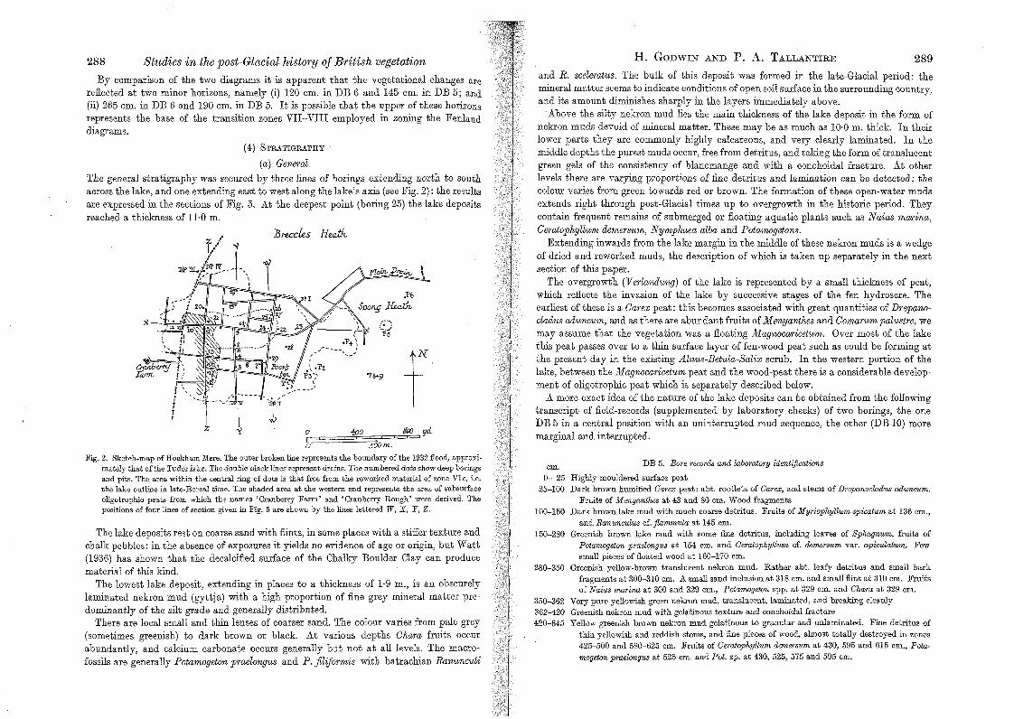
The general stratigraphy was secured by three lines of borings extending north to south across the lake, and one extending east to west along the lake's axis (see Fig. 2): the results are expressed in the sections of Fig. 5. At the deepest point (boring 25) the lake deposits reached a thickness of n·o m.
--,_/~;---
t
J3reccks HeaiJv
o ['-=o
foo
Fig. 2. Sketch-map of Hockham Mere. The outer broken line represents the boundary of the 1932 flood, approximately that of the Tudor lake. The double black lines represent drains. The numbered dots show deep borings and pits. The area within the central ring of dots is that free from the reworked material of zone VIe, i.e. the lake outline in late·Boreal time. The shaded area at the western end represents the area of subsurface oligotrophic peats from which the names' Cranberry Farm' and' Cranberry Rough' were derived. The positions of four lines of section given in Fig. 5 are shown by the lines lettered lV, X, Y, Z.
The lake deposits rest on coarse sand with flints, in some places with a stiffer texture and chalk pebbles: in the absence of exposures it yields no evidence of age or origin, but Watt (1936) has shown that the decalcified surface of the Chalky Boulder Clay can produce material of this kind.
The lowest lake deposit, extending in places to a thickness of 1·9 m., is an obscurely laminated nekron mud (gyttja) with a high proportion of fine grey mineral matter predominantly of the silt grade and generally distributed.
There are local small and thin lenses of coarser sand. The colour varies from pale grey (sometimes greenish) to dark brown or black. At various depths Chara fruits occur abundantly, and calcium carbonate occurs generally but not at all levels. The macrofossils are generally Potamogeton praelongus and P. jiliformis with batrachian Ranunculi
H. GODWIN AND P. A. TALLANTIRE 289 and R. sceleratus. The bulk of this deposit was formed in the late-Glacial period: the mineral matter seems to indicate conditions of open soil surface in the surrounding country, and its amount diminishes sharply in the layers immediately above.
Above the silty nekron mud lies the main thickness of the lake deposit in the form of nekron muds devoid of mineral matter. These may be as much as 10·0 m. thick. In their lower parts they are commonly highly calcareous, and very clearly laminated. In the middle depths the purest muds occur, free from detritus, and taking the form of translucent green gels of the consistency of blancmange and with a conchoidal fracture. At other levels there are varying proportions of fine detritus and lamination can be detected: the colour varies from green towards red or brown. The formation of these open-water mUds extends right through post-Glacial times up to overgrowth in the historic period. They contain frequent remains of submerged or floating aquatic plants such as N aias marina, Ceratophyllum demersum, Nymphaea alba and Potamogetons.
Extending inwards from the lake margin in the middle of these nekron muds is a wedge of dried and reworked muds, the description of which is taken up separately in the next section of this paper.
The overgrowth (Verlandung) of the lake is represented by a small thickness of peat, which reflects the invasion of the lake by successive stages of the fen hydrosere. The earliest of these is a Carex peat: this becomes associated with great quantities of Drepanocladus aduncum, and as there are abundant fruits of Menyanthes and Comarum palustre, we may assume that the vegetation was a floating Magnocaricetum. Over most of the lake this peat passes over to a thin surface layer of fen-wood peat such as could be forming at the present day in the existing Alnus-Betula-Salix scrub. In the western portion of the lake, between the Magnocaricetum peat and the wood-peat there is a considerable development of oligotrophic peat which is separately described below.
A more exact idea of the nature ofthe lake deposits can be obtained from the following transcript of field-records (supplemented by laboratory checks) of two borings, the one DB 5 in a central position with an uninterrupted mud sequence, the other (DB 10) more marginal and interrupted.
cm. 0- 25
25-100
100-150
150-280
280-350
350-362 362-420 420-645
DB 5. Bore recorM and laboratory identifications
Highly mouldered surface peat Dark brown hummed Carex peat: abt. rootlets of Carex, and stems of Drepanoclcu1us aduncum.
Fruits of Menyanthes at 43 and 80 cm. Wood fragments Dark brown lake mud with much coarse detritus. Fruits of Myriophyllum spicatum at 136 cm.,
and Ranunculus cf. jlammula at 145 cm. Greenish brown lake mud with some fine detritus, including leaves of Sphagnum, fruits of
Potamogeton praelongus at 154 cm. and Ceratophyllum cf. demersum var. apiculatum. Few small pieces of floated wood at 160-170 cm.
Greenish yellow-brown translucent nekron mud. Rather abt. leafy detritus and small bark fragments at 300-310 cm. A small sand inclusion at 318 cm. and small flint at 310 cm. Fruits of Naias marina at 300 and 329 cm., Potamogeton spp. at 329 cm. and Chara at 329 cm.
Very pure yellowish green nekron mud, translucent, laminated, and breaking cleauly Greenish nekron mud with gelatinous texture and conchoidal fracture Yellow greenish brown nekron mud gelatinous to granular and unIaminated. Fine detritus of
thin yellowish and reddish stems, and fine pieces of wood, almost totally destroyed in zones 425-500 and 580-625 cm. Fruits of Ceratophyllum demersum at 430, 595 and 615 cm., Potamogeton praelongus at 525 cm. and Pot. sp. at 430, 525, 575 and 595 cm.

290 Studies in the post-Glacial history of British vegetation 645-705 Yellow greenish brown gelatinous nekron mud. Whitish (possibly calcareous) granules in places.
.705-755
755-875
875-880 880-900
cm. 0- 26
26- 70
70- 80 SO-102
102-200
200-210 210-220
220-233
233-315
315-380
380-523
523-600
Granular texture. Yellow greenish brown nekron mud with strong lamination and some silt content: small nests
of sand from 675 to 695 cm. Stiff, putty-textured, very silty nekron muds, greenish grey to dark grey: dark brown from 845
to 860 cm. Calcareous and somewhat banded from 785 to 815 cm. Sparse pollen content at 765 and 775 cm. Frequent Pediastrum and occL diatoms at 785,795 and 805 cm.
Brownish grey coarse sand with some content of lake mud Coarse whitish brown sand with small flint pebbles
DB 10. Bore recorils and laboratory identificatwns
Loose surface peat with frequent birch twigs Black, highly humified Calluna, Sphagnum, Eriphorum peat. Calluna twigs at 43, 45, ahd 68 cm.
Band of Campylopus at 57-60 cm. Scirpus caespitosus and Eriphorum cf. angustifolium, leaf bases at 68 cm.
Transitional Brown reed.swamp peat with thinleaffragments cf. Carex, stringy decayed rhizomes cf. Cladium,
occL wood fragments towards base, Salix cf. cinerea leaf at 101 cm., Menyanthes fruits at 99 cm.
Sharp transition to a lake mud. From 102 to 132 cm. with much coarse detritus, and dull brown; 144-155 cm. drab olive green; 155-1S0 cm. purest mud of reddish brown colour, gelatinous and il(-termittently laminated. Fruits of Naias marina at 145 and 155 cm.
Nekron mud with coarse detritus Dull reddish nekron mud with much coarse detritus of thin yellowish rootlets, leaves and stems
cf. Carex: some moss stems. Fruits of Potamogeton cf. praelongus and Nymphaea cf. alba at 215 cm. Small reddish wood fragment at 220 cm.
Dark grey-brown nekron mud of porridgy texture. Small hard lumps of dried and reworked lake mud in a softer matrix
Brown nekron muds with occL zones of fine detritus. Coarse detritus in upper 10 cm.: slight silt content from 280 cm. down. Fruits of Potamogeton obtusifolius at 254 cm. P. pusillus (group) at 262 and 280 cm. Potamogeton cf. polygonifolius at 309 cm.
Calcareous nekron mud with slight silt content. Lime as whitish granules, sometimes concentrated in particular layers. Horizontal Chara stems at 320 and 347 cm.
Stiff putty-textured highly silty lake muds, very variable in colour from light grey to dark purplish brown or black. Occasional zones of fine detritus. (These muds in other bores proved to have variable lime content, some Cham fruits, and frequent fruits of Potamogetonfiliformis. and Myriophyllum spicatum.)
Coarse brownish sand, muddy in the upper 2 cm. with small bluish and brown flint fragments
(b) Late-Boreal lowering of lake level
It has already been pointed out that the sections show a wedge-shaped deposit of reworked material extending from the lake margin into the undisturbed nekron muds, and they have formed part of the ,series in DB 6.
They take the form of a porridge of small hardened lumps of nekron mud, still strongly laminated, but set at all angles in a softer matrix of coarse detritus mud. In shape the fragments may be irregular but often they occur as flakes. Toward the centre of the lake the deposit thins and becomes a granular coarse detritus. It is apparent that this deposit was formed by a lowering of lake-level, with a drying-out of the margin, and a reworking of the surface of the exposed lake muds by erosion and wave-action on the shore. From the field records it was possible to map the approximate lake boundary at the time of minimum water-level (see Fig. 2): within this area reworked muds are absent, and the mud
H. GODWIN AND P. A. TALLANTIRE 291 succession is uninterrupted. The macrofossil plant remains, which include Salix wood and leaves, a CaUuna twig, fruits of Eleocharis palustris and of Menyanthes palustris all indicate shore conditions rather than deep water: fruits and seeds of open-water spe~ies are also present, but they are often clearly derived from the mud pebbles.
In the bores DB 13, 15 and 16 there is evidence of a division or duplication of the reworked horizon but this is absent elsewhere.
. If we compare the pollen diagram for DB 6 (Fig. 4), which includes the reworked deposit, WIth that of DB 5 (Fig. 3), which comes from the central basin that never dried out it will be apparent that whereas the features characteristic of the opening of zone VII are recognizable in both, and also those typical for zone V and subzone VIa, there is no correspondence in between these levels. It appears that from DB 6 all deposits of the subzones VIb and VIc are missing, and it is therefore of the greatest significance that between 320 and 350 cm. we find the peat to have been reworked. We cannot escape the conclusion that at this point a late-Boreal lowering of the lake-level has truncated the series and produced an unconformity in the sequence of deposits. Naturally the pollen analyses from the reworked material itself are extremely equivocal.
The configuration of the lake basin and the nature of its water supply leave us no alternative but to suppose that this lowering of lake-level was due to climatic causes. This agrees well with evidence from many British and European sites where drying horizons, tree-stump layers and so forth have often been referred to this period.
(c) Oligotrophic communities and drainage effects
The present vegetation of the former lake, described by Ellis (Mosby, 1935), in areas not pastured or planted consists entirely of alder-birch-sallow fen scrub with a rich herbaceous ground flora including such species as Carex paniculata, Dryopteris thelypteris, Ulmaria palustris, with Menyanthes palustris and Comarum palustre in the wetter and more open parts. In view of this it was surprising to find part of the area named 'Cranberry Rough', and the farm itself named 'Cranberry Farm', for no living Oxycoccus (or its associates) now occurs there.
The borings however have disclosed the existence, at the western end of the mere, of a substantial area where acidic peat occurs between the Magnocaricetum peat and the surface fen-wood peat (see Fig. 2). This peat contains Sphagnum cf. squarrosum, Calluna vulgaris, Eriophorum vaginatum and E. angustifolium, Oxycoccus quadripetalus, Scirpus caespitosus, together with Campylopus sp., and Molinia caerulea. It reaches a depth of as much as 1·1 m. in places. Its presence indicates unmistakably that oligotrophic communities successfully invaded the sedge-fen and makes it indeed probable that they continued until very recent time.
It seems probable that the extension offen-woods over this acid peat followed the decay of the drainage works which had for two or three centuries allowed some peat cutting, cultivation and pasturage on the drier parts of the mere surface. It does not, however, seem possible to recognize in the peat deposits evidence for the effects of the initial drainage of the lake, nor can it be said with certainty what may have been removed from the surface by cutting or oxidation.

292 Studies in the post-Glacial history of British vegetation
HOCKHAM MERE DB 5 p~es of r;"td. &u . polk.
_I i I ~r-r-rl I I I r-rr--r--r- Jr--.-, -'-r,-r--.-,--o,---"r--r, --.-, --'-'-'-, ~'-T _0 20 40 60 Ko 0 400 20 4-0 600 lOO 2040 0 20.tO 60 la 100 120 J4.Q }AO 1%0 2JX!220.&
cm
+
f ULMUS QU£'R.CUS TILlA ALNUS
/PINE} !LH} [OAK} fLI/1E] [ALDER]
El) SALlX !WILLOW}
COR.YLUS [HAZEJ
ZONE.
VllI
IV
HI
11
I I ! ! !
02040/.;08'0 ~~I , , ,L-L~LI ~,~,~~~I~'~~'-L,~I-L~ o 20400 20 -;OD 20 40 600 200 2040 0 20 100 200
Fig. 3. Tree pollen diagram for DB 5. This is an nninterrupted series from deep water.
H. GODWIN AND P. A. TALLANTIRE 293
HOCKHAM M ERE - DB 6. 1941 puwoliuJ<5 of t.otaL t= poll.vc
r"*~""-'::>--'--.---r--.--r~ ~,.-i ' ,.-~[",..,-r-I .-,-.-,-...... ..,...,r,I-.--.'~'~'~'.,.'.....,........,1 o 20 1..00 zo 0 20 40 60 0 20 0 20 10 0505 20 0 10 -f{) 00 go 100 J20 Ita 160 JS() 200 20 40 60 to
BETULA PINUS l<tMVS OUERWS llLlA ALNUS FAGU50\RPINVS CORYLUS
zONE
Vlll
vllb
IV
III
11
cm [BlU"} /PINE} /£411/ [CW<} ftlHE} ALDER} }JEw! /ilORNBwV /HAZEL}
110 ~ k to' ~hb la ~ k~~h~b ;0 ~ /r, $0 11111~ J~ ,Go 1~
Fig. 4. Tree pollen diagram for DB 6. This series is interrupted by the Jate·Boreal phase oflow lake levels, during which the muds of subzones VIb and VIe were eroded and reworked.
(5) FLORISTIC LIST
Table 1 summarizes the identifications of macroscopic plant remains from various parts
of the lake deposits. As would be expected, the land species are restricted to the bottom (late-Glacial) layers
when the lake was first forming, and a few from the reworked muds of the late-Boreal dry period. Submerged and floating aquatic plants are abundantly represented in the nekron muds: species of fen and reed-swamp communities are naturally abundant in the uppermost layers but occur freely also in the earliest stages of the lake's history. Plants of oligotrophic communities are found only in zone VIII.

Table 1. Macroscopic remains from Hockham Mere (N.B. The table indicates the number of bores in which remains of each species occurred. Instances of sin~le specimens are indicated by a § sign, otherwise seyeral specimen~ occurred in the one boring, or the species ;as frequent in many borings.)
Species Type A B C D E F G H Betula nana L. Fr. l§ Polygonum nodosum Pers. (= P. petecti- S. l§ cale Druce)
Potentilla spp. Ach. l§
Ranunculus cf. jlammula L. Ach. l§ l§ R. sceleratus L. Ach. 2 Carex cf. pseudocyperus L. Fr. 2 Carex cf. rostrata Stokes Fr. I 6 2 l§ l§ Carex spp. Fr. 4 2 4 Eleocharis palustris s.l. Fr. 3 M enyanthes trifoliata L. S. 4 2 20 9 4 Comarum palustre Ach. 20 2 2 Cladium mar£scus Fr. I§ C. mariscus Rhiz. 3 Epilobium parvijlorum Schreb. S. l§ Lycopus europaeus L. Ntlt. 3 Mentha cf. aquatica L. Ntlt. Gicuta virosa L. Fr. 3 Scirpus lacustris agg. Fr. 1 3 Sparganium cf. minimum Fr. F.st. I§ Ranunculus (Batrachian group) Ach. 4 Ceratophyllum demersum L. Fr. 4 2 2 1§ C. demersum var. apiculatum Fr. 1§ Naias marina L. Fr. 1§ 9 17 3 N. jlexilis Rostk. & Schmidt Fr. 1§ Nuphar luteum Srn. Fr. I§ Nymphaea alba L. S. 1 M yriophyllum spicatum L. Fr. 3 5 M. spicatum L. L. 2 M. alternijlorum DC. Fr. 1§ Chara spp. Oosp. 2 21 Potamogeton densus L. F.st. 1§ P. obtusifolius Mert. & Koch F.st. 16 2 2 4 4 P. filiformis Pers. F.st. 6 P. praelongus W ulf. F.st. 6 10 15 P. natans L. ·F.st. 2 2 P. pusillus group F.st. 3 2 I§ I§ P. polygonifolius Pourr. F.st. I§ I§ Potamogeton spp. F.Bt. 3 2 5 3
Betula cf. pendula Roth. Fr. 2§
B. pubescens Fr. I§ 3 B. pubescens C.s. I§
B. pubescens X rana Fr. 3 Betula spp. W. 4
Salix spp. W. I 4
Salix spp. L. 3
Calluna vulgaris Hull. Tw. 12 I§
Oxycoccus quadripetalus Gilib. I,. I Eriophorum spp. L.b. 4 Eriophorum cf. M olinia coerulea L.b. 2
(L.) Moench Eriophorum cf. Scirpus caespitosus L. L.b. 3 Sphagnum cf. squarrosum L. 6 Campylopus spp. L. 2 Drepanocladus aduncus gr. L. 20 20 D. aduncus cf. sendtnerii L. 10
Ach. =achene; C.s. = cone scale; Fr. = fruit; F.st.= frnit stone (pyrene); Ntlt. =nutlet; L.b. =leaf·base; Oosp. = oospore; Rhiz. = rhizome; L. = leaf; Tw. = twigs; W. = wood; S. =seed. .
A. The surface fen peats. B. The oligotrophic peats (see Fig. 2) probably formed within the historical period. C. The fen peats (Carex and Hypnum) below beds A and B. Zone VIII broadly speaking. . D. The non-silty lake muds from regions of the lake which lack the re-worked horizon or an eqUlvalent.
Post-Glacial broadly speaking. E. The lake muds above the main re-worked horizon. I.e., post zone VIc. F. The re-worked horizon itself. Zones late VIa-VI-bearly VIc. G. The non-silty lake muds below the re-worked horizon. Zones IV-V-VIa. H. The silty lake muds as a whole. Late-Glacial, and the early part of zone IV.
.~
~ ~
~
!~i ]-
~.~ .g u 0 • t.?I>
'" ,
.:ii ",.
:;<1;:. .~::..:
.. : ::01::": .: ',<: .. :.
,,,'." .' .~ .. .. " ... ,J.
. .... ~.,..
:: ::4: . ::.(
.' ..... .....
:.: : ~:4: ' ...•.
,: : ::~:

296 Studies in the post-Glacial history of British vegetation
Below are given notes on a few species of special interest: Betula spp. A single fruit of B. nana L. (Fig. 6) was recovered from 839 to 870 cm.,
DB 27, deep in the silty nekron muds and presumably therefore late-Glacial. One fruit of Betula cf. pendula, and three fruits + one cone-scale of B. pubeseens were found in the same muds. In addition these yielded three fruits which, on a basis of shape and size,
Fig. 6. Fossil fruit of Betula nana L. from the late· Glacial silty muds of DB 27 (x 12·5).
d
b
).
:> e >
Fig. 7. Fossil seed of Epilobium cf. parviflorum Schreb. a, front; b, side; c back (all x 33); d, detail of back; e, spines.
appeared comparable with those of the hybrid, B. nana x pubeseens. These hybrids exist abundantly in suitable regions of north-west Europe still, and have been recorded previously from late-Glacial or early post-Glacial deposits (Godwin, 1945; Jessen, 1949) as well as from inter-Glacial deposits. (Jessen & Milthers, 1928). Hockham Mere lies far outside the present range of B. nana: its restriction in range since late-Glacial times has been commented on previously (Godwin, 1949; Conolly, Godwin & Megaw, 1950).
Epilobium parviflorum Schreb. A single seed thus identified came out of the lateGlacial silty nekron mud at 1100-1110 cm. in DB 25 (Fig. 7).
A few similar seeds have been recovered from late-Glacial deposits in Stowbedon Mere and the Waveney Valley (Tallentire, unpubl.). Miss Andrew identified Epilobium pollen from various levels in zones IV and earlier in DB5. This pollen belongs to the same type
as E. parviflorum. Myriophyllum alterniflorum D.C. The highly characteristic pollen grains of this species
were recovered from various late-Glacial samples in DB 5, one fruit was identified from 840 to 850 cm. in DB 27 (also late-Glacial). The winter-buds of a Myriophyllum were found in the late-Glacial muds of DB 27 at 795-797 cm., but these may well have been of M. spicatum, fruits and pollen of which were commonly identified in late-Glacial muds as well as fruits in the nekron muds formed after zone VIe.
b Fig. 8. Fossil fruits from Hockham Mere. a, Naiasflexilis Rostk. & Schmidt; b, N. marina L. The former species
is represented by one fruit only, the latter by abundant specimens from zones VI and VII (see Fig. 9).
(Outlines x 12; surface detail x 24.)
'-)
-0
~
01
tr
~
't'
~
~
:!
'" 'SI
2
0
I
"" , I ,
'S
t~ j~
Sg; ~
H. GODWIN AND P. A. TALLANTIRE 297
~:;g + +
od 'U :...c ~~ ::l » :'> + ?- oo~ ,
~2 od ~-A 5 ~5 ~
~ :Ji I + +~ I I ++ I , , ++ ~
I + '" , '" I 0>-,
+++ + • I . co:5 , . 00 ,<}
, I + ';f->-I 1')"'" , + ::::.;3
I + ",,',.. I I
: + "":5 ~.(,J
, + , ~~ ",. ++ + + + , I
,,;;'j
"i+ I
~. I ++ I~ I :r.!i: I ;')i
I
~ \~ :).. ).. , +
I :::q
I : <..:1,
I
1 I~ I + I I
I
~~ 1~ I + I I
.~ ,
~ I~ :++ ~ , , ,
I .S I ++
~ ~ '" " , t+++ Z , ~ :; ~j f1' i I +I-
~ Q
1.0
~t- '" ..........
::; Q..? '<s-. , , , ., <:> ..J
~ ~ I~ ~1 ~ 1 ' , , ~
~ '" "' § '<>-~ i '!i
,~ ~ ~ \~ ~ ~ ~ .~~ 0
.,.~ ~t ~ ~ ~j 'S 0
~ ~ ~ I~ j ~., ..t. -g ~ .;]
• ~ ~
,
I ~+: + .~-u ,
~ ~~ I~ , + Ell is
I' +
I zx . I ~
0 0 0 0 0 0 .~
.:. ~ ,Q ..f.o .... -.P [00;

298 Studies in the post-Glacial history of British vegetation
Naias jlexilis Rostk. & Schrnidt. A single fruit was identified from DB 10 at 141 cm., that is in the upper detritus muds just below the Magnoearieetum peat: it is considerably later than zone VIe (see Fig. 8a). Naias jlexilis has not been recorded living from East Anglia, and indeed now has a very restricted northern range. Other post-Glacial records of the plant have been made in Britain and Ireland, so that it very probably belongs to the category of species whose range here has notably diminished in the post-Glacial period.
Naias marina L. The fruits of this species were recovered so abundantly that their distribution could be shown diagrammatically (Fig. 9). Where direct pollen analytic dating is possible, in DB 5, N. marina occurs in zone VIIb. Elsewhere it occurs infrequently below the reworked deposits of subzones VIb and VIe, and very commonly within and just above them. There can be no doubt that this species flourished particularly in the Boreal and early-Atlantic periods, but it probably persisted until the lake was overgrown by fen. This suggests that the climate has not become particularly unfavourable to it and is in line with its survival in three Norfolk Broads to the present day. In Ireland there seems so far to be no record of its discovery after the Boreal period (Jessen, 1949; Mitchell, 1950).
b c
Fig. 10. Fig. 11.
Fig. 10. Fossil fruit of Polygonum nodosum Pers. (=P. petecticale Druce) x 8.
Fig. 11. Hockhain Mere: pyrenes of Potamogeton. a, P. obtusifolius; Mert. & Koch, b, P. perfoliatus; c, P. filiformis. Pers. ( x 10.)
Polemonium coeruleum L. Two pollen-grains undoubtedly referable to this species were recorded from the late-Glacial section of DB 5. This species, now so restricted in its British range, occurred widely in late-Glacial time (Godwin, 1949).
Polygonum nodosum Pers. (=P. peteetieale Druce). A single fruit of this species (Fig. 10) was identified from DB 27 at 817-837 cm. (late-Glacial). In view of the prevalence of , ruderals' and 'weeds' in deposits of this period it is interesting to find that Simmonds (1945) approvingly quotes Buchli's opinion of the plant as 'an" archaeophyte", a species having no known natural habitat, always associated with human disturbance'.
Brief references to other species in the floristic list are given in the appropriate sections. Potamogeton densus L. A single pyrene of this species was found at 139 cm. in bore
DB 14: this is later than VIe. Potamogeton filiformis Nolk. Pyrenes of this species were identified from late-Glacial
layers in six borings. It is a species of high northern range, commonly recognized in the late-Glacial deposits of Scandinavia. It has been likened by Samuelsson (1934) to Naias marina in having suffered a later restriction of range in its fresh-water habitats.
H. GODWIN AND P. A. TALLANTIRE 299
(6) LATE-GLACIAL CONDITIONS
In §3 reasons were given for recognizing the end of the late-Glacial p8riod, the zone III-IV boundary, at the horizons indicated. It remains to characterize the late-Glacial deposits at Hockham, to reconstruct so far as may be the vegetational and climatic conditions, and to see whether it is possible to recognize evidence for the AIleron oscillation, expressed by the relatively mild period of zone II, separating the colder periods of zones I and III (Godwin, 1947).
The tree-pollen diagrams (Figs. 3, 4) disclose a striking preponderance of Betula throughout the late-Glacial sections of the deposits. This may be taken, with the evidence from macroscopic remains, to indicate the presence of tree birches, B. pubeseens (and possibly B. pendula), together with B. nana and its hybrid with B. pubeseens. The high value for the non-tree/tree pollen ratio suggests that the birches did not form a total forest cover, and this is borne out by the evenly distributed and evenly graded, fine mineral matter (probably wind-borne) incorporated in the lake muds throughout the period. Macroscopic evidence suggests that willows accompanied the birches, and there is a continuous Salix pollen curve correspondingly. Although Pinus pollen is present in such large amount, macroscopic remains are absent. We take it that this pollen has been windborne from a distance, as J essen takes to be the case in Ireland. The increased proportion of pine in the upper section of the late-Glacial deposits (zone IIl), we take to be due to a weakening of the local density of the tree-birches rather than any absolute increase of pine. This explanation is supported by the presence of small amounts of the pollen of such warmth-demanding tree genera as Ulmus, Quercus, Tilia and Alnus, along with quite large amounts of Gorylus. It is unlikely that these are secondarily derived, for virtually no characteristically inter-Glacial or pre-Glacial types accompany them: they also must be attributed to wind-carriage from a distance. As would be expected, they are present in greatest amount in zone III since, like Pinus, they are emphasized by the thinning of the local birch woodland.
The non-tree pollen curves set out in Figs. 12 and 13 were based upon early analyses in which a limited number of herbaceous pollen types was recognized. They show, however, that grass pollen was abundant through the late-Glacial stages and diminished at the onset of the post-GlaciaL This can most probably be explained, as we have already mentioned, as due to a more or less open birch woodland in the late-Glacial, and closed birch woods afterwards. To take advantage of recent improvement in the technique of identifying the pollen of herbaceous plants, the original slides of the eighteen lowermost samples of DB 5 were re-analysed in 1950 by Miss R. Andrew: the results are set out in Table 2, and in Fig. 12. It is immediately apparent from these that in the late-Glacial muds at Hockham there is present that assemblage of types so highly typical of the period at other sites reccntly investigated in Britain and western Europe, i.e. the genera Armeria, Artemisia, Atriplex, Gentaurea (G. scabiosa type), Empetrum, Epilobium, Galium, Helianthemum (H. chamaecistus type), Plantago (media), Polemonium (caeruleum), Myriophyllum (alternijlorum), Rumex (cf. A cetosa) , Sanguisorba, Thalictrum, Ulmaria, Valeriana.
The considerable numbers of grains referable to various types of the Compositae and to the families of Cruciferae, Chenopodiaceae, Caryophyllaceae, Labiatae, Umbelliferae indicate the presence of a rich flora. As with other late-Glacial floras, the assemblage carries the stamp of open habitats and freedom from forest dominance. Species now behaving

0(; 6~ '100S: 'f
.• '$!g aas 1Xl",$,,!p aenod eel~ llawaodsallOO 109 .£ \Ia lO] 1Xl"lll,,!p uorrod aal~·aoN '(;l .jJ!g
ox 0$ 0p' crff ozr 001 0.$ 09 at O? of. 06 er?' oz 0 Qc 0 OT 0 ~ 0 OQl aS 09 av O,? 0 010 I I I I l ' I I I I~ 'T'I I I 1'1 W?
n
m
/,1
(\
~ It''
'ell/,
'1n(\
11l{\ JNOZ
'l.NVld <;g'd3H a~frJjHd<;<;N~3J
+ ~ ...
--r--- J ---- !-
S:lIl.W1OV <;3S<;V'dS>
OOI OJ/ 09' o(,f oZ' 007 03 09 0"1 Ol DOlO 0"1 OJ 0 07 0'2 0 m: O~! 00, 0 00/
I I I I I I-Ll I , I I I 1......w..J ..L..c.J...L.LJ'~,c.l..1 -'---1.-'.--<--1
ot6J =rJOd·?WJ T"10'] jo ~d
~ ~(] Td3N WVH>i:JOH
109 am.LNYTIYL 'V . d aNY NI.M.aOD 'H
~~oooooooooo~oo~~~~~~~~~ ~~~~~~~~~~~~~g~~~S
+.
+.
+.
+. +-
++~. ...... , ..... >1---'+-+.
+++1-'+' +1-'l-' ......... +. + +.
+ -++.
.. +.
++. +.
+++. +.
+. +. -++""-+.
+. +. +- ++ .. +.
+1-'>-''''''''- ~++++. +. +-
>-'+++. ~+- +
+- - +. ++- )-I- +-
+>-'++. +- +- t:V1-'+.
++, +- +_ + .. +t:V+_
+++-
+- +- - - +-
+++. +. - ++
+- ++. +. +-
+++1-'0
t:Vl-'CO· I-'Cil 00 t:-.:J- .::.0+"
+.
++ 1-" .. r-")-It:Vl--" +-
+- +. .J,... +-
+- +C/.:II--'+-
++-
- +- + 1--'+-
A rmeria 'VUlgaris
A rcrostaphylos
Centaurea cf. scabiosa
Empetmm niqrwm.
Ericoiil
Helianthemum
cf . ..111 econopsis
Plantago media
Polemonium
Scabiosa cf. Succisa
Rumex acetosa
Galium
A triplex-Ghenopoilium
CaryophyIJaceae
Coropositae, Asteroid (Taraxacum)
Compositae, Matricarioid (Solidago)
Compositae, Senecio (? Bellidae)
Compositae, :M:iscellaneoUS
Cruci!erac
Sanguis01'ha
Labiatae
Epilobium
Alisma
Polygonum amphibium
Umbelli!erae
Ulmaria
Valeriana
Ranunculus
Equisdwm spores
Spa'rganiwm
Typha lotifolia
M yriophyllum spicatum
M. alternijlmum
t~· .. .. .. +' +++ Filicales
~~~;~w~I;~g~>-,~+++
+-- . ~- +
++- +. +. - ++
++- + ~
++ +- ++
+ l-,:lCO,p.. ... C;JI-'I-'l-.:J~~·
+. + .....
Pediast'fUlm,
Ulmus
Quercus
Tilia
Alnus
Faqus
Gorylus
Abies
8
~ co !'"
~ ~ ~ ~ ~
.<J>
g _01

302 Studies in the post-Glacial history of British vegetation
partly or wholly as ruderals or weeds are represented in the pollen by Rumex cf. acetosa, Plantago media and in the macrofossils by Polygonum lapathifolium.
The character of the flora as a whole can be compared with that of the late-Glacial in Cornwall (Conolly et al. 1950), Nazeing (Essex) (Hazzledine Warren, Godwin and Allison, unpubl.), vVhitrig Bog (Mitchell, 1948). Similar assemblages have been also found at sites in the Waveney Valley near to Hockham (Tallantire, unpubl.).
The small numbers of herbaceous pollen that we were able to count, and the present uncertainty of the actual species involved and of the role of the known and unknown species in the plant communities of the late-Glacial period persuade us to the view that there are insufficient grounds for constructing a diagram which eliminates some and groups others of the pollen types. Fig. 14 therefore represents merely the most frequent pollen types expressed as percentages of the total pollen count. It is upon consideration of this, along with the table of less frequent types (Table 2) that we have based our tentative zonation of the base of DB 5, and thence by extension of DB 6 also.
It seems reasonable to us to attribute the late-Glacial organic muds at Hockham to zones Il and Ill, that is to the mild and succeeding colder period of the Allemd oscillation. In DB 5 we place the boundary at approx. 830 cm., and in DB 6 at 570 cm. Thus the colder conditions of zone III are indicated by some thinning of the birch woods which allowed a stronger relative representation of all pollen brought in from a distance, such as pine, hazel and the warmth-requiring tree-genera already mentioned. It also permitted the representation of the herbaceous late-Glacial flora in greater total frequency (see grass pollen and total non-tree pollen curves) and also in greater variety (see Table 2). Despite much labour in field and laboratory it proved impossible to secure macrofossil remains adequate to elucidate the stratigraphy further: no doubt the small slopes which prevented recognizable solifiuction effects also prevented incorporation of macroscopic plant remains in the lake deposits. We are strengthened in our interpretation of these deposits by the recognition given by Jessen (1949) to the presence of the Aller0d in the published but unzoned tree pollen diagram of DB 5.
In a return visit made in October 1949 to the site of DB 5 we secured, by repeated sampling with the Hiller borer, about 2000 g. dry weight of the calcareous and silty nekron muds between 790 and 825 cm. from zone Ill. These were sent to Prof. W. F. Libby of Chicago, who has very kindly returned to us the result of radio-carbon assay. The measured activity corresponds to an age of 6555 ± 280 years, the mean of two determinations. This is clearly too young by several thousand years and may indicate an inherent disqualification in these muds for this type of assay. The regularity of the pollen sequence and the purity of the pollen spectrum in zone IV are against any mass disturbance of the muds able to have introduced younger muds from above, but this may perhaps have been caused by contamination in the several contiguous borings needed to secure a large enough sample (Godwin, 1951).
THE RECORD OF DISFORESTATION
In 1944 a preliminary note was published (Godwin, 1944b) showing how the non-tree pollen diagram DB 5 from Hockham afforded evidence for the anthropogenic origin of the Breckland heaths. It followed a brief review (Godwin, 1944a) of Iversen's extremely important paper on 'Land Occupation in Denmark's Stone Age' (Iversen, 1941), in which
. H. GODWIN AND P. A. TALLANTIRE 303 It was clearly demonstrated how fluctuations in tree and n the vegetational developments when land tillin hi . on-tree pollen curves express by axe and fire. Since that time similar e~ects hg
preb
stonc people cleared primev~l forest . parts of Europe, and in western England th Save een s.hown by pollen analysts m other
e omerset raIsed bogs have given evidence of
HOCKHAM MERE - DB 6.
GR.ASSES cm. AOUATICS
fER.NS SPHAGNUM ER.1COID HE.R.B5 NON TR.E.( POLLE.N
~J to 1~ 10 "
Fig. 13. Non-tree pollen diagram for DB 6. F or cOlTesponding tree-pollen diagram see Fig. 4.
p~onoun(c~d d fl~ctuation in pre~istoric agricultural activity in association with climatic c a~gde dO wm, !948). In VIew of these pUblications the present evidence need be conSI ere only bnefly.
thrWhe:her we consider DB 5 or 6, it will be apparent that the non-tree/tree pollen ratio ou~ out zones V, VI and VHa remains at such very low values that we must su ose
the n~lghbourhood of the lake to have been fully afforested. At a well-defined leve/t ever (m DB 5 at 310 cm and DB 6 t 195 ) h ow-
. a cm. , t e total non-tree pollen is seen to rise 20-2

304
v> w Z o
N
z hi
U)
a: Ul :r: I-
o ~ fJ.J <.> « a: Ul 0-r U
" 0.. f-U)
er UJ :r: I-
o
x --.I « (f)
« -' =>
w I-
~ &i ~lJ) ~ CO ~ Cl
'" ~ ~ I u
I
Studies in the post-Glacial history of British vegetation
I 1:::1
1 1=1 I~I I I
I
'" :: ~. i? co '" m '"
",. I'- '" ~ '" :g s. ~ '" U) '" '" '" CD I'- ... '" '" <0 U)
-
;;; 2 ~
0 '" ~
0
" g
2 ~
0 p.tU ~II 11111 JIU 11111 I11 1111 11 1111 I11 1111 JIIIIIil
IIIV -CD
~ I11 1111 0 ~ rUlJ W ,,\1 IIU
'" I" 0 l.lJJ.' '\ !V " -~
~
"'
'2 on
2 ~
0 ~ 0 <Xl
!t 0
" 0
'" I ID .... /' ... / . ... Jete]···:1 . '" .• , , ... ). '. )., .). • .. / .•.• - .. 1*1-1-.' 11 :r .. , ..... , ... , ... , ... , ., 0
o U)
r-
o o 00 ,
o "' '" .
o '" I
H. GODWIN AND P. A. TALLANTIRE 305 rapidly to a maintained level of about 60 % of the total tree pollen. The chief components of the total non-tree pollen curve are the curves of Gramineae, of ericoid pollen, and of miscellaneous herbaceous plants of many types. Along with these and pursuing a similar course are the curves for fern-spores and Sphagnum spores. Moreover, although in smaller amount, the highly recognizable pollen of Plantago lanceolata displays a Comparable course, and this is beyond doubt a species of low or open vegetation and not of high forest.
The wide open expanses of the Breckland 'heaths', with their great extents of AgrostidoFestucetum, Caricetum arenariae, Pteridietum and Callunetum interspersed with valley fens, coniferous plantations, and much altered open deciduous woodland, are known to have been sheep-walk in the Middle Ages, and to have degenerated since then into vast rabbit warrens, locally and sporadically formed in periods of high agricultural prices. The ecological status of the heath communities has been variously assessed in the past: low rainfall and porous shallow soil have been held responsible for the treelessness, but some ecologists, such as Farrow, have consistently held that this was due to maintained heavy grazing.
It seems certain that these non-tree pollen curves, coming as they do from a site inside the north-eastern margin of the Breckland, carry back the history of the' heaths' into the prehistoric period. By reference to the zoning of tree pollen diagrams it will be evident that the forest clearance began shortly after the critical decrease of Ulmus pollen at the end of zone YHa, which roughly corresponds with the opening of the NeoIithic period. Not only were Iversen's conclusions based upon similar effects of NeoIithic forest clearance in Denmark, but we must note that in the NeoIithic period the great flint mines of Grime's Graves, only a few miles from Hockham, were in active operation, and other signs of NeoIithic occupation are frequent throughout the Breck country. There is no reason at all for thinking that climatic change at this time could have led to such forest destruction.
At 85 cm. in DB 5 and at 65 cm. in DB 6 the total non-tree pollen curve rises still further, to values exceeding that for the total tree pollen, and we may certainly take this as due to further forest destruction. In DB 5 we shall note that this increase is primarily due to grasses and to the miscellaneous herbs, although the latter do not maintain the high value first achieved. By contrast the Sphagnum spores and ericoid pollen do not increase. (In DB 6 the ericoid pollen increases, perhaps in relation to the local development of oIigotrophic peat already described.) These features seem to point to a new type of forest clearance leading to the formation chiefly of grass-heath. Unfortunately, the difficulties of zoning the upper parts of the diagram allow us no means of dating this intensification of forest destruction: one might perhaps expect it to be an effect of the Iron Age cultivation comparable. with that shown in Somerset and elsewhere, or it might equally relate to the early historic Saxon period when Thetford was the capital city of East Anglia.
These pollen analyses were made in 1940 and 1941, and it is fairly certain that were they to be repeated now many more types could be separately recognized and recorded. It seems beyond doubt that the present curves show an anthropogenic origin of the Breckland heaths in Neolithic time, and Dr A. S. Watt, speaking from his great knowledge of the ecology of the Breckland, is perfectly prepared to accept this hypothesis of their origin.

306 Studies in the post-Glacial history of British vegetation
SUMMARY
Hockham Mere is the site of a lake situated near to Thetford just within the north-east margin of the East Anglian 'Breckland', and drained in post-Tudor times. Stratigraphic examination has disclosed deep deposits of organic lake muds (nekron muds), and pollen analysis of these indicates the nature of vegetational changes of the region from the lateGlacial until historic time. Tree birches were present in late-Glacial time along with Betula nana and hybrids: a high non-tree/tree pollen ratio, high mineral content of the lake muds, and the presence of species or genera characteristic of open habitats, all point to the presence of some bare ground and incomplete forest cover. The pollen spectrum has a typical late-Glacial assemblage of types, and it is possible to recognize pollen-zones n and In, which correspond to the Aller0d climatic oscillation.
In the late-Boreal period the lake dried up considerably: its boundary at this time has been established. Very late in its history it became overgrown by sedge-fen, and in its western portions developed an oligotrophic vegetation, which though since destroyed, no doubt was responsible for the ancient name of 'Cranberry Rough' applied to part of the lake basin. In Boreal and early-Atlantic layers abundant finds have been recorded of the fruits of Naias marina: N.flexilis was found in zone VII or VIII. Numerous other records, chiefly of fruits and seeds of aquatic plants, are reported.
Mter a period of dense forest growth through Boreal and early-Atlantic time, some clearance is recorded by the sharp rise in several categories of non-tree pollen, and this is attributed to clearance by Neolithic man. The disforestation was accentuated at a later time which cannot be certainly identified. These effects appear to demonstrate the anthropogenic and prehistoric origin of the great Breckland heaths.
REFERENCES
Baden-Powell, D. F. W. (1944). On the occurrence of Hessle Boulder Clay at Happisburgh, Norfolk, containing a flint core. Geol. Mag. 81,207.
ConolIy, A. P., Godwin, H. & Megaw, E. M. (1950). Studies in the post-Glacial history of British vegetation. XI. Late-Glacial deposits in Cornwall. Philos. Trans. B, 234, 397.
Farrington, A. & Mitchell, G. F. (1951). The end· moraine north of Flamborough Head. Proc. Geol. Assoc. Land.
Godwin, H. (1940). Studies of the post·Glaciallllstory of British Vegetation. Ill. Fenland pollen diagrams. Philos. Trans. B, 230, 239.
Godwin, H. (1944a). Neolithic forest clearance. Nature, Land., 153, 51l. Godwin, H. (1944h). Age and origin of the 'Breckland' heaths of East Anglia. Nature, Lonil.,
154,6. Godwin, H. (1945). A submerged peat bed in Portsmouth harbour. Data for the study of post-Glacial
history. New Phytol. 44, 152. Godwin, H. (1947). The late-Glacial period. Sei. Prog. 138, 185. Godwin, H. (1948). Studies of the post-Glaciallllstory of British vegetation. X. Correlation between climate,
forest composition, prehistoric agriculture and peat stratigraphy in sub-Boreal and sub-Atlantic peats of the Somerset levels. Philos. Trans. B, 233, 275.
Godwin, H. (1949). The spreading of the British flora considered in relation to the late-Glacial period. J. Ecol. 37, 140.
Godwin, H. (1951). Comments on radiocarbon dating for samples from the British Isles. Am. J. Sci. 249,
30l. Iversen, J.( 1941). L"'ndnami Danmarks Stenalder. Dansk Geol. Undersog. HR. 66. Jessen, K. (1949). Studies in late Quaternary deposits and flora-history of Ireland. Proc. Ray. Irish Acad.
B, 52, 85. Jessen, K. & Milthers, A. V. (1928). Stratigraphical and paleontological studies of inter-Glacial fresh-water
deposits in Juthnd ",nd North-West Germany. Dansk. awl. Undersog. lIR. 48.
307 H. GODWIN AND P. A. TALLANTIRE
~tchell, G. F. (1948). Late-Glacial deposits in Berwickshire. New Phytol 47 26"
MltB~~~Oo~r ~ s1;;~~)' Naias jlexilia (recent and fossil) and N. marina (fosSllJ in -ireland. Rep. VlIth Int.
Moshy, J. E. G. (1935). Hockham Mere. Trans. Noriolk Norw. Nat. Soc. 14 61 . Saxn:elsson, G. (1934). Die Verbreitung der h6heren Wasserpflanzen in Nord;uro'pa A la Ph
. . c ytogeogr. suec.
SiIn:rnonds, W. N. (1945.). ~olygonum. Biological Flora British Isles. J. Ecol. 33. 117. Watt, A. S. (1936). Studies ID the ecology of Breckland I Climat il d '.
" e, so an vegetatIOn. J. Ecol. 24, 117.