Glacial Lake Licking: Late-Glacial Drainage Diversion and the ...
10
The Ohio State University 2006-06 Glacial Lake Licking: Late-Glacial Drainage Diversion and the Formationof Black Hand Gorge, Licking County, Ohio Frolking, Tod A.; Pachell, Matthew A. The Ohio Journal of Science, v106, n3 (June, 2006), 103-111. http://hdl.handle.net/1811/36461 Downloaded from the Knowledge Bank, The Ohio State University's institutional repository Knowledge Bank kb.osu.edu Ohio Journal of Science (Ohio Academy of Science) Ohio Journal of Science: Volume 106, Issue 3 (June, 2006)
Transcript of Glacial Lake Licking: Late-Glacial Drainage Diversion and the ...

The Ohio State University
2006-06
Glacial Lake Licking: Late-Glacial Drainage
Diversion and the Formationof Black Hand
Gorge, Licking County, Ohio
Frolking, Tod A.; Pachell, Matthew A. The Ohio Journal of Science, v106, n3 (June, 2006), 103-111.http://hdl.handle.net/1811/36461
Downloaded from the Knowledge Bank, The Ohio State University's institutional repository
Knowledge Bank kb.osu.edu
Ohio Journal of Science (Ohio Academy of Science) Ohio Journal of Science: Volume 106, Issue 3 (June, 2006)
OHIO JOURNAL OF SCIENCE 103T. A. FROLKING AND M. A. PACHELL
Glacial Lake Licking: Late-Glacial Drainage Diversion and the Formationof Black Hand Gorge, Licking County, Ohio1
TOD A. FROLKING AND MATTHEW A. PACHELL2, Department of Geology and Geography, Denison University, Granville, OH43023; Anadarko Petroleum Corporation, The Woodlands, TX 77380
ABSTRACT. Numerous narrow, steep-walled valleys cut through the uplands of the Glaciated AppalachianPlateaus section of east-central Ohio. In Licking County, eastward-advancing glacial ice blocked thewest-flowing paleo drainage east of Newark forming Glacial Lake Licking. Lake waters ultimatelyovertopped a drainage divide south of Hanover causing the erosion of Black Hand Gorge and reversalof the Licking River drainage. Cutbanks and cores into late-Wisconsinan terraces along the Licking Riverand its tributaries above the Gorge reveal dense, laminated (± 1.0 mm) to massive, calcareous, graylacustrine silt disconformably overlain by 1.0-6.0+ m of oxidized fluvial sand and gravel overlain in turnby sandy silt (Chili loam soil). Lacustrine silt has been found from elevations of 228 m (748 ft) above sealevel in cores in the Licking River floodplain to 255 m (838 ft) in a small lateral tributary. The 230 m(755 ft) elevation of the modern Gorge channel bed indicates at least 25 m of incision since the lake wasimpounded. Two radiometric dates (33,440 ± 1060 and 21,660 ± 120 years BP) as well as stratigraphic andpedogenic relationships indicate that Glacial Lake Licking was impounded in the late Wisconsinan andthat gorge cutting occurred relatively early during the last glacial maximum. No weathering zone,indicating a significant period of subaerial exposure, has been noted either at the silt/gravel contact orwithin the fluvial gravel.
OHIO J SCI 106 (3):103-111, 2006
1Manuscript received 16 October 2004 and in revised form 15December 2005 (#04-21).
2Previously at the Department of Geology, Utah State University,Logan, UT 84322
INTRODUCTIONThe Glaciated Allegheny Plateaus physiographic re-
gion (Brockman 1998) affords some of Ohio’s mostvaried and rugged topography due in part to the inter-actions of resistant bedrock with geologically recentglacially induced drainage modifications. Dammed ordisplaced streams have produced numerous “youthful”steep-walled valleys with bedrock channels, massiveoutcrops, high local relief, and often isolated vegetationcommunities. Many of these areas are now state parks,natural areas, and scenic rivers. Most of these steep,narrow valleys in east-central Ohio were formed aswest- or north-flowing streams in preglacial or earlyPleistocene valleys were blocked by the advance of anice sheet from the north or west. Glacial lakes thenexpanded until new outlets were cut through topo-graphic lows in the impounded drainage basins. Someprominent narrow valleys in east-central Ohio includeClear Fork of the Mohican River (State Park) southwestof Loudonville, in Ashland County; the Kokosing River(State Scenic River) west of Gambier, in Knox County;Black Hand Gorge (State Nature Preserve) on the LickingRiver between Hanover and Toboso in Licking County;Jonathan Creek east of Mt. Perry in Perry County; LittleRush Creek north of Bremen, in Fairfield County; andClear Creek west of Rockbridge, in Hocking County(Fig. 1). Black Hand Gorge (historically referred to asBlack Hand Narrows) is notable both for its length ofabout 3.6 km and for its narrow width of 40-50 mthrough the heart of the Gorge (Fig. 2). Many other
regional gorges have broader valley floors perhaps in-dicative of older ages, weaker bedrock or greater streamerosion power over time.
Black Hand Gorge is the type locality for the Black
FIGURE 1. Regional map of modern (black) and deep-stage (dashed)drainage patterns of east central Ohio showing the approximate limitsof Illinoian (light gray) and late-Wisconsinan (dark gray) glacialdeposits (ice margins from Pavey and others 1999), several prominentbedrock narrows (CF = Clear Fork, KR = Kokosing River, BHG = BlackHand Gorge, JC = Jonathan Creek, LRC = Little Rush Creek, CC = ClearCreek, McC = McConnelsville), cities (MV = Mount Vernon, C =Coshocton, Columbus, N = Newark, Z = Zanesville, L = Lancaster), andthe town of Hanover (H) just north of Blackhand Gorge.
104 VOL. 106GLACIAL LAKE LICKING, BLACK HAND GORGE
Hand Sandstone Member of the Mississippian upperCuyahoga Formation that forms the steep, inner portion(20+ m of relief) of the Gorge (Malcuit and Bork 1987).The sheet-like members of the superjacent Logan For-mation form the more modest upper slopes of theGorge up to elevations of 305 to 315 m (1000 to 1040 ft)with the Pennsylvanian Pottsville Formation formingthe higher ridge tops in the area (Bork and Malcuit1979; DeLong 1972).
Black Hand Gorge and the Licking River system weresignificant to Ohio’s socioeconomic history with thedevelopment of the Ohio-Erie Canal. The canal utilizedthe Gorge and followed numerous stretches of now-abandoned, deeply buried paleo valleys. Portions of themodern Licking River and the North and South Fork tribu-taries occupy broad valleys of the Teays-age Cambridgeand Groveport rivers valleys. These valleys were sub-sequently deepened by the Deep Stage Newark andUtica rivers (Stout and others 1943; Coffee 1958; Dove1960). The timing of these deep valley-forming phasesremains uncertain. Workers now assign much of the Teays-Mahomet drainage development to the early Pleistocene(Melhorn and Kempton 1991) with the Deep Stage in-
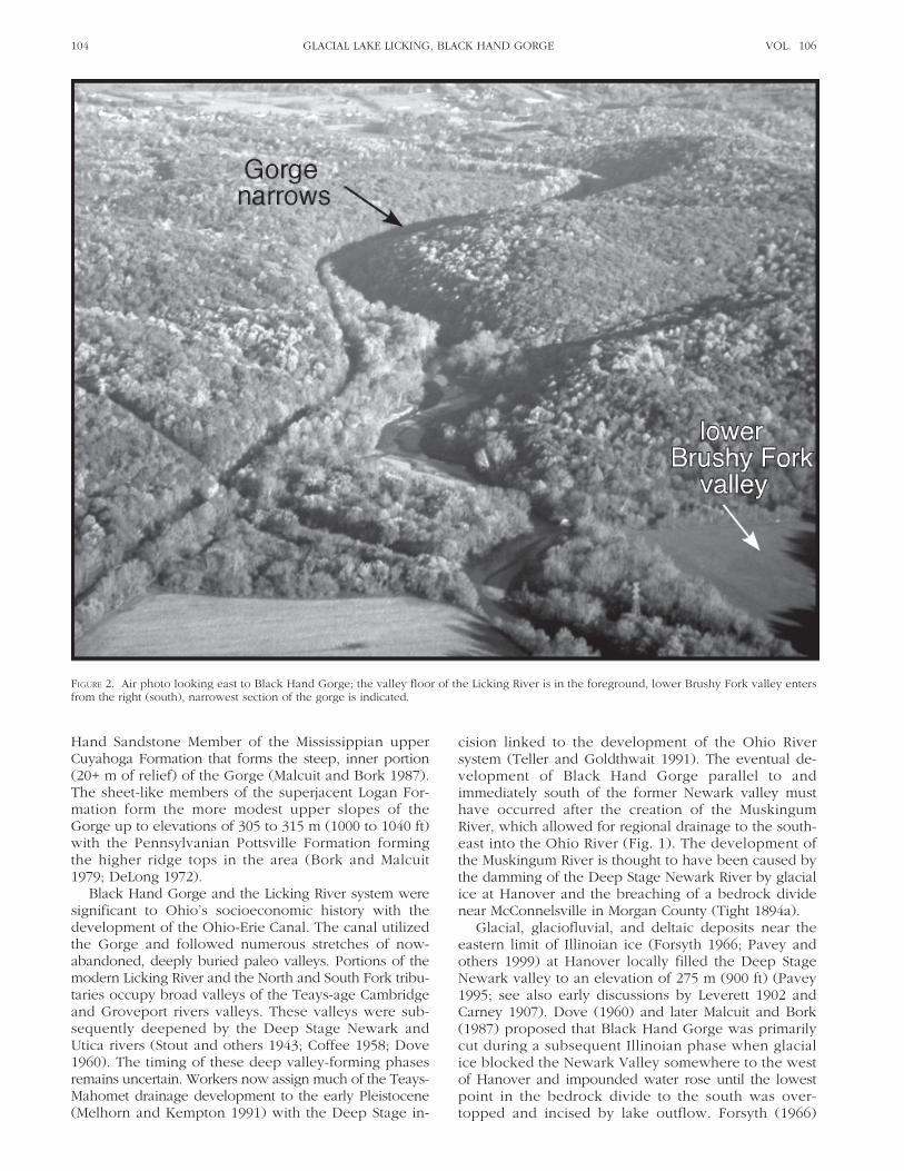
FIGURE 2. Air photo looking east to Black Hand Gorge; the valley floor of the Licking River is in the foreground, lower Brushy Fork valley entersfrom the right (south), narrowest section of the gorge is indicated.
cision linked to the development of the Ohio Riversystem (Teller and Goldthwait 1991). The eventual de-velopment of Black Hand Gorge parallel to andimmediately south of the former Newark valley musthave occurred after the creation of the MuskingumRiver, which allowed for regional drainage to the south-east into the Ohio River (Fig. 1). The development ofthe Muskingum River is thought to have been caused bythe damming of the Deep Stage Newark River by glacialice at Hanover and the breaching of a bedrock dividenear McConnelsville in Morgan County (Tight 1894a).
Glacial, glaciofluvial, and deltaic deposits near theeastern limit of Illinoian ice (Forsyth 1966; Pavey andothers 1999) at Hanover locally filled the Deep StageNewark valley to an elevation of 275 m (900 ft) (Pavey1995; see also early discussions by Leverett 1902 andCarney 1907). Dove (1960) and later Malcuit and Bork(1987) proposed that Black Hand Gorge was primarilycut during a subsequent Illinoian phase when glacialice blocked the Newark Valley somewhere to the westof Hanover and impounded water rose until the lowestpoint in the bedrock divide to the south was over-topped and incised by lake outflow. Forsyth (1966)

OHIO JOURNAL OF SCIENCE 105T. A. FROLKING AND M. A. PACHELL
FIGURE 3. Map of Lower Licking River study area showing generalized terrain (50 m contours with uplands above 300 m in light gray) with modern drainageand valleys, field sites (dots locating cores and bank exposures, X locates Longaberger building, CP locates Cartnal-Postle site), approximateextent of glacial Lake Licking (255 m contour, dark gray), approximate location of Late-Wisconsinan ice maximum (stipling), and some roadsand towns to aid in site location (N = Newark, M = Marne, H = Hanover, T = Toboso).
mapped Wisconsinan lake deposits in Claylick andBrushy Fork valleys to the west of the Gorge (Fig. 3). Ifthese sediments are Wisconsinan, their presence wouldpreclude a full cutting of the Gorge during Illinoian time,but Forsyth provides no justification for the age of thematerial. The Licking County Soil Survey provides muchinformation about the character and distribution of sur-ficial materials in the region (Parkinson and others 1992).Numerous soil bodies with parent materials attributed toWisconsinan glaciolacustrine deposits are mapped intributary valleys to the Licking River between Newarkand Black Hand Gorge, but again the age of the sedi-ments is not justified.
Tight (1894b) coined the term Lake Licking for alarge lake formed by glacial deposits blocking the paleo-valley at Hanover to the east and the damming of thesouthwest-flowing paleodrainage by some undeterminedglacial or interglacial agent to the southwest. This lakewould have inundated present-day Newark and wasthought to be responsible for the extensive flat terrain
and fine-grained sediments in the vicinity of BuckeyeLake in the south-central portion of the county. Thispaper focuses on the distribution, stratigraphy, and agesof lacustrine and fluvial sediments immediately upstream(west) of Black Hand Gorge in the Licking valley and itstributaries (Fig. 3). The name Glacial Lake Licking, a modi-fication of Tight’s original usage, refers to the ice-dammedlake that led directly to the formation of Black HandGorge and the modern Licking River system. Field rela-tionships, laboratory data, and two radiometric dates in-dicate that lacustrine sediments and overlying fluvialgravels upstream from the modern gorge are late Wis-consinan in age and thus the cutting of the Gorge oc-curred at that time. The gorge’s narrow floor, steep innerwalls, and actively incising side tributaries reflect its youth.
MATERIALS AND METHODSTopographic maps and the Licking County Soil Sur-
vey (Parkinson and others 1992) were carefully ex-amined to ascertain the distribution of relevant landforms

106 VOL. 106GLACIAL LAKE LICKING, BLACK HAND GORGE
and materials including bedrock hills, Illinoian drift, Wis-consinan lacustrine, eolian and fluvial deposits, andHolocene floodplain deposits. Stream banks of the lowerLicking River and its tributaries (Claylick, Little Claylick,Brushy Fork, and Rocky Fork) were examined for ex-posures of fine-grained, non-fluvial sediments by canoeand on foot. A trailer-mounted Giddings Probe was usedon floodplains and terrace surfaces to core downthrough fluvial or glaciofluvial sediments into the under-lying lacustrine sediments. At some locations, shallowsediment cores were taken with hand-held soil augers.Water well logs filed at the Division of Water, OhioDepartment of Natural Resources, were studied forcorrelations of deeper valley fill sediments.
Selected samples from steam bank exposures as wellas hand- and power-augured drill cores were air driedand disaggregated using mortar and pestle in the lab.Sediment particle size analysis utilized sieves and thepipette method (Gee and Bauder 1986). Calcite, dolo-mite, and total calcite equivalent contents of calcareoussamples were determined by the rate of CO
2 evolution
using a Chittick apparatus following the methodologyof Dreimanis (1962).
RESULTS AND DISCUSSIONOverview of Glacial Lake Licking
The Glacial Lake Licking basin includes the mainstem of the modern Licking River whose previous west-ward path was blocked by ice advancing from the west.The eastward limit of the ice advance is not clearly ex-pressed topographically. Subsurface borings and foun-dation excavations performed during the construction ofthe Longaberger Corporate Headquarters (Fig. 3) reveala complex stratigraphy of glacial till, lacustrine, andperhaps glaciodeltaic deposits suggestive of an ice-marginal location (BBC&M Engineering 1995). TheAmanda silt loam, a soil formed in late Wisconsinan till,is mapped in small hollows up to elevations of about275 m (900 ft) two km to the southwest of this site butis not mapped to the east (Parkinson and others 1992).
The highest elevation of the impounded lake is un-certain but would have been limited either by theelevation of the glacial fill at Hanover or more likely bythe elevation of the divide where Black Hand Gorge wassubsequently cut. This divide may have been breachedand eroded repeatedly with successive ice advances.The impounded lake may have extended into andwould have received significant discharge and sedi-ments from Rocky Fork draining from the north, Claylickand Little Claylick entering from the south, and BrushyFork entering from unglaciated terrain to the southeast.The terrain and relief of the contributing tributary basinsare similar and the regional lithology changes onlymodestly with the eastward bedrock dip. The basins dodiffer significantly, however, in their glacial historiesand in the distributions of Pleistocene deposits. There-fore erosion did yield somewhat different material todifferent embayments of the glacial lake.
In Licking County, the Mentor, Glenford, Fitchville,and Luray soil series represent a drainage association ofsoils developed in glaciolacustrine deposits on Wisconsinan
terraces and lake plains (Parkinson and others 1992). Un-fortunately, these soils are defined by their silty parentmaterial and drainage conditions, reflected in soil hori-zonation and mottling pattern, not by the actual originof the silt and hence cannot be used to map distribu-tions of former lakes. In the Claylick and Little Claylickbasins, for example, the Mentor soil is mapped up toelevations of at least 260 m (860 ft) in the main valleysand 284 m (930 ft) in small tributary valleys. There isno well-defined upper limit to its distribution. In addi-tion, the soil can be found on moderately sloping terrainsthat seem inconsistent with a lacustrine origin. Many ofthese soil bodies likely developed in some mixture ofloess and silty colluvium rather than lake sediment. Bio-pedoturbation associated with soil development makesit difficult to distinguish these materials from lacustrinesilt within the solum. While this study made use of thesoil survey data for general patterns, it necessarily reliedon stream bank exposures and deeper cores to identifyand characterize lacustrine sediments within the basin.
The best exposures of fine-grained lacustrine sedi-ments occur discontinuously along stream banks wheremodern channels are actively cutting into high terraceremnants (typically capped by Chili loam soils) in thelower reaches of tributary valleys of the Licking Riverbetween Newark and Hanover. Terrace cutbanks at theselocations reveal dense, cohesive, commonly parallel-laminated, calcareous silt unconformably overlain by2.0 to 8.0+ m of fluvial sand and gravel topped by 0.4to 1.0 m of silt loam to very fine-sandy loam (Figs. 4, 5).Stream channel incision and lateral migration followingthe deposition of the high terrace sand and gravel haseroded both the terrace deposits and the underlyinglacustrine sediment such that the lake silt is not exposedin banks along most low terraces and modern floodplainreaches. Where present, the cohesive silt resists channelerosion and frequently forms ledges extending out intothe channel below the gravel bank. The presence of sim-ilar cohesive, calcareous silt in numerous borings intoterraces and on floodplains below the depth of themodern channel bed suggests that this material repre-sents a laterally continuous lacustrine deposit (Fig. 3).
The elevations of clearly-identifiable lacustrine sedi-ment extend from an elevation of 228 m (748 ft) underthe floodplain of the Licking River to 248 m (813 ft) inlower Rocky Fork and 252 m (825 ft) in middle BrushyFork, to 255 m (838 ft) at Sleepy Hollow on the southflank of Licking Valley near the probable ice front.Several sites on dissected Illinoian surfaces and intributary valleys reveal lacustrine-like deposits up to atleast 254 m (835 ft). Thus, the lake extended to a maxi-mum elevation of at least 254 m (835 ft) with a maximumdepth of at least 25-30 m.
Composition of Lacustrine SedimentsThe texture of bulk samples of lacustrine sediment
ranged from fine silty clay (D50 = 0.002 mm) to fine
sandy silt (D50= 0.030 to 0.060 mm). The mean particle
diameters are typical for underflow sedimentation indistal regions of glacier-fed lakes (Ashley and others1985). Note that the data presented in Table 1 is limited
OHIO JOURNAL OF SCIENCE 107T. A. FROLKING AND M. A. PACHELL
TABLE 1
Mean particle size statistics and mean carbonate contents for groups of lacustrineand diamict samples from different basins in the Glacial Lake Licking drainage.
Area Material D50 (mm) D
50 (φ) Inman σφ* Carbonate (%) Cal/Dol
Lower Rocky Fork (7)** Lacustrine 0.0048 7.7 ± 1.4 -3.0 ± 0.8 9.0 ± 2.9 0.25 ± 0.06
Lower Claylick (3) Lacustrine 0.0055 7.5 ± 1.4 -3.4 ± 0.4 11.4 ± 2.4 0.37 ± 0.12
Lower Brushy Fork (6) Lacustrine 0.022 5.5 ± 0.4 -2.3 ± 0.5 18.5 ± 1.1 0.09 ± 0.05
Licking Valley (4) Lacustrine 0.0048 7.7 ± 0.8 -3.1 ± 0.7 9.7 ± 2.4 0.34 ± 0.05
Licking Valley (3) Diamict (Till) 0.013 6.3 ± 0.1 -5.7 ± 0.4 12.1 ± 1.3 0.36 ± 0.02
* (D(φ16
) + D ( φ84
) ) / 2; ** # of samples
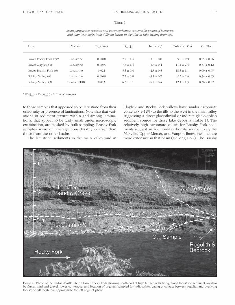
FIGURE 4. Photo of the Cartnal-Postle site on lower Rocky Fork showing south end of high terrace with fine-grained lacustrine sediment overlainby fluvial sand and gravel, lower cut terrace, and location of organics sampled for radiocarbon dating at contact between regolith and overlyinglacustrine silt (scale bar approximate for left edge of photo).
to those samples that appeared to be lacustrine from theiruniformity or presence of laminations. Note also that vari-ations in sediment texture within and among lamina-tions, that appear to be fairly small under microscopicexamination, are masked by bulk sampling. Brushy Forksamples were on average considerably coarser thanthose from the other basins.
The lacustrine sediments in the main valley and in
Claylick and Rocky Fork valleys have similar carbonatecontents ( 9-12%) to the tills to the west in the main valleysuggesting a direct glaciofluvial or indirect glacio-eoliansediment source for those lake deposits (Table 1). Therelatively high carbonate values for Brushy Fork sedi-ments suggest an additional carbonate source, likely theMaxville, Upper Mercer, and Vanport limestones that aremore extensive in that basin (DeLong 1972). The Brushy
108 VOL. 106GLACIAL LAKE LICKING, BLACK HAND GORGE
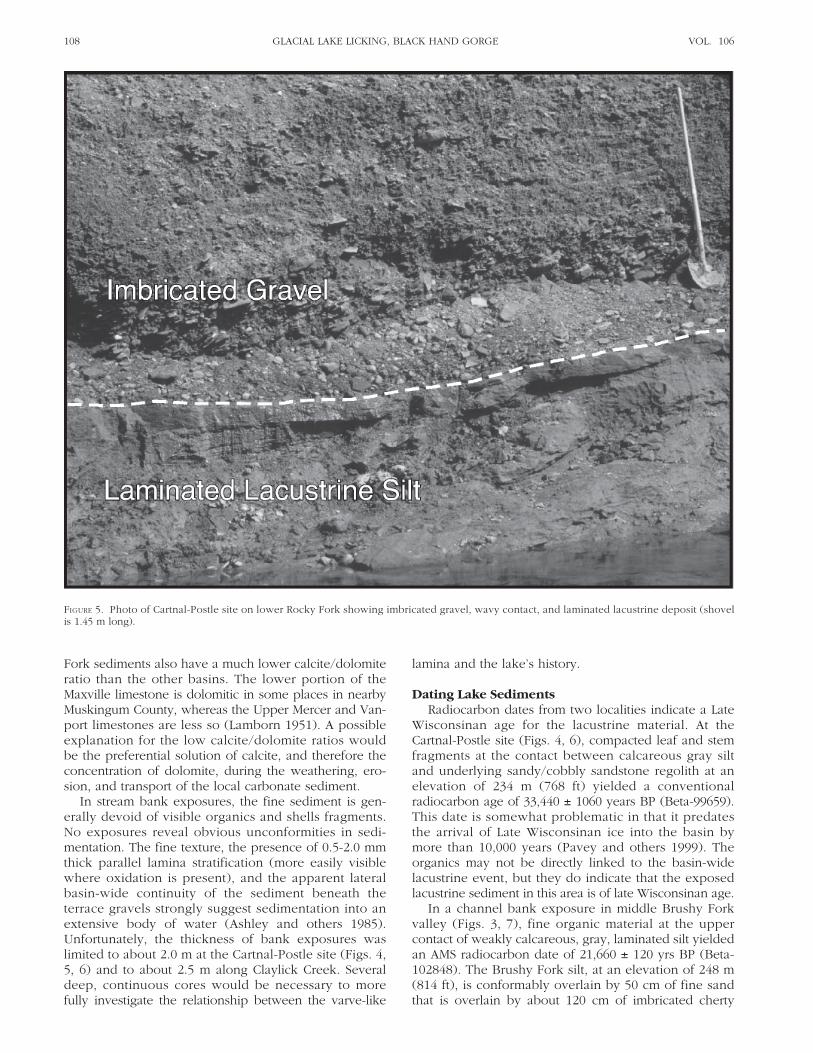
FIGURE 5. Photo of Cartnal-Postle site on lower Rocky Fork showing imbricated gravel, wavy contact, and laminated lacustrine deposit (shovelis 1.45 m long).
Fork sediments also have a much lower calcite/dolomiteratio than the other basins. The lower portion of theMaxville limestone is dolomitic in some places in nearbyMuskingum County, whereas the Upper Mercer and Van-port limestones are less so (Lamborn 1951). A possibleexplanation for the low calcite/dolomite ratios wouldbe the preferential solution of calcite, and therefore theconcentration of dolomite, during the weathering, ero-sion, and transport of the local carbonate sediment.
In stream bank exposures, the fine sediment is gen-erally devoid of visible organics and shells fragments.No exposures reveal obvious unconformities in sedi-mentation. The fine texture, the presence of 0.5-2.0 mmthick parallel lamina stratification (more easily visiblewhere oxidation is present), and the apparent lateralbasin-wide continuity of the sediment beneath theterrace gravels strongly suggest sedimentation into anextensive body of water (Ashley and others 1985).Unfortunately, the thickness of bank exposures waslimited to about 2.0 m at the Cartnal-Postle site (Figs. 4,5, 6) and to about 2.5 m along Claylick Creek. Severaldeep, continuous cores would be necessary to morefully investigate the relationship between the varve-like
lamina and the lake’s history.
Dating Lake SedimentsRadiocarbon dates from two localities indicate a Late
Wisconsinan age for the lacustrine material. At theCartnal-Postle site (Figs. 4, 6), compacted leaf and stemfragments at the contact between calcareous gray siltand underlying sandy/cobbly sandstone regolith at anelevation of 234 m (768 ft) yielded a conventionalradiocarbon age of 33,440 ± 1060 years BP (Beta-99659).This date is somewhat problematic in that it predatesthe arrival of Late Wisconsinan ice into the basin bymore than 10,000 years (Pavey and others 1999). Theorganics may not be directly linked to the basin-widelacustrine event, but they do indicate that the exposedlacustrine sediment in this area is of late Wisconsinan age.
In a channel bank exposure in middle Brushy Forkvalley (Figs. 3, 7), fine organic material at the uppercontact of weakly calcareous, gray, laminated silt yieldedan AMS radiocarbon date of 21,660 ± 120 yrs BP (Beta-102848). The Brushy Fork silt, at an elevation of 248 m(814 ft), is conformably overlain by 50 cm of fine sandthat is overlain by about 120 cm of imbricated cherty

OHIO JOURNAL OF SCIENCE 109T. A. FROLKING AND M. A. PACHELL
FIGURE 6. Topographic map of Lower Rocky Fork basin showing bankexposure and coring sites (CP indicates Cartnal-Postle bank exposurewith radiocarbon date) and the general distribution of bedrockuplands (BrU), dissected Illinoian drift (Illinoian), Wisconsinan terraceswith lacustrine, fluvial and eolian sediment (Wis. Lc&Al), and Holo-cene alluvial deposits (HAl); entrance to Black Hand Gorge in south-east corner; base map from Hanover Quadrangle, 7.5 minute series.
gravel. Two cores taken within 170 m of the modernchannel along a 350 m transect southward across theBrushy Fork terrace (Fig. 7) reveal lacustrine materialsat similar depths to those in the bank exposure withoverlying interbedded sand/gravel and silty units. Thenext core at 230 m was entirely silt to very fine sandlacustrine material to an elevation of 251 m (824 ft)topped with a probable loess cover. This 5.0+ m coreshowed no subsurface weathering zone, which supportsa Late-Wisconsinan age for the lake sediment. The coreat 350 m on the lower footslope was similar and wascapped with what appeared to be poorly sorted silt, sandand gravel colluvium. While uncertainty remains, thefluvial sand and gravel in the valley center appears tobe inset into the lacustrine sediment in a cut and fillsequence as the environment changed from lacustrineto fluvial. Lateral relationships suggest the gravel in thestream bank is not conformable with the underlying siltbut does indicate that the lacustrine sediment couldonly have extended an additional 2.0+ m above thedated sediment before the lacustrine regime ended asthe Gorge was cut. Note that this valley floor pattern iswidely expressed through the region where Chili loamsoils (terrace gravels) are flanked by Mentor and Glen-ford silt loam soils on the valley floor margins.
FIGURE 7. Topographic map of the Bear Hollow and Brushy Fork con-fluence showing coring sites (X indicates bank exposure with radio-carbon date) and the general distribution of bedrock uplands (BrU),Wisconsinan terraces with lacustrine, fluvial and eolian sediment(Wis. Lc&Al), and Holocene alluvial deposits (HAl); base map fromToboso Quadrangle, 7.5 minute series.
The Brushy Fork date is similar to a 21,400 ± 600 yrsBP date for wood recovered from the basal zone of a18 m thick till unit in the South Fork Licking valley about7.0 km southwest of Newark. Goldthwait (1958) inter-preted this till to represent the initial advance of the LateWisconsinan Scioto Lobe into the region. The date is onthe early side of the 21,000 yrs BP average date for themaximum extent of the early Late-Wisconsinan ice ad-vance (Rosengreen 1974). Integrating the Brushy Forkobservations with this data on the regional ice advance,the Gorge was likely cut quite early in the Late Wiscon-sinan, shortly after ice arrived on the scene.
Upper Limits of Lacustrine SedimentationTo help define the upper limit of lacustrine sedi-
mentation, tributary valley floors and dissected Illinoiandrift surfaces at elevations of 250-260 m (820 to 850 ft)were cored (Figs. 6, 7). Some locations reveal siltyprofiles in which possible lacustrine sediment occurswithin modern soil profiles. The oxidized and biotur-bated material at these locations has lost any resemblanceto cohesive laminated lacustrine sediment. Similarlytextured late glacial eolian silt and reworked colluvialsilt on footslope and valley floor surfaces cannot bereadily differentiated from lake sediments within soilprofiles. At some sites, silty-clay material extended welldown through the soil C horizon, at depths below 125cm, and here a lacustrine origin could be more confi-dently assigned.
In the Claylick and Little Claylick basins and in theburied valley area west of Hanover, sand and gravel

110 VOL. 106GLACIAL LAKE LICKING, BLACK HAND GORGE
deposits of probable Illinoian age occur through a rangeof elevations on the now dissected terrain. Several flatsurfaces above 258 m (845 ft) had 120+ cm of silt loam(mainly Wisconsinan loess) over sand and gravel. Atsurface elevations of 250-255 m (820-836 ft) the strati-graphy was less consistent. Silt caps were usually thinnerbut several cores revealed what appeared to be lac-ustrine sediment at elevations of about 253 m (830 ft).Many sites were on modest slopes and it is possiblethat erosion through the late glacial period may haveremoved any lacustrine sediment that had been de-posited. Given the modest number of cores taken fromthese locations, a clear upper limit to lacustrine sedimentcannot confidently be assigned at this time.
Terrace Sand and GravelThe contact between the post lacustrine sand and
gravel and the underlying dense, cohesive, calcareoussilt is typically wavy and unconformable (Fig. 4). Fewexposures reveal obvious channel cuts into the finesediment, but observations are restricted because thelengths of bank exposures are limited to tens of metersat most. At many localities, the upper zone of lacustrinesilt in contact with overlying gravel is oxidized. Weinterpret this as post-depositional oxidation linked tothe aeration of the gravel and not a former weatheringsurface. The fluvial sand and gravel unit shows poorlydeveloped parallel bedding characteristic of shallowbraided channels (Figs. 4, 5; Church and Gilbert 1975).These deposits are very similar sedimentologically topro-glacial outwash deposits that occur in Wisconsinanoutwash terraces mapped further to the west (Forsyth1966). Lacking direct glacial sources, the braided charac-ter of the stream channels in tributary valleys musthave been due to a relatively heavy channel bed loadresulting from high rates of sediment delivery in a peri-glacial landscape (Amba and others 1990; Frolking andSzabo 1998; Mol and others 2000). Fining-upwardsequences or fine-grained channel fills characteristic ofmeandering channels have not been found in the terracedeposits.
Most of these terrace remnants are mapped as Chililoam soils (Parkinson and others 1992) and revealmodern soil development that extends through the loamcap into the underlying gravel. No clear cut-and-fillstructures or weathering zones within the sand andgravel have been observed suggesting relatively rapiddeposition without significant periods of subaerial ex-posure. Soil profile development appears to be on parwith Ockley soil profiles developed in silt over late-Wisconsinan outwash in the central and western partsof the Licking River basin (Parkinson and others 1992)and clearly lacks the depth of leaching and soil develop-ment found in Illinoian outwash terraces. Integratingthese stratigraphic and pedogenic observations, weinterpret the sand and gravel as well as the overlyingloamy cap to be Late Wisconsinan in age.
Exposures and cores along a stepped-terrace se-quence in the Licking River valley near the probable icemargin (see terrace delineations in Forsyth 1966) revealgenerally thin (1.0-3.0 m) calcareous gravel deposits
over calcareous glacial diamict and lacustrine deposits.This suggests a degradational channel regime, perhapsin response to both ice margin movement and the con-tinued cutting of the Gorge and lowering of the localbase level. Some terraces such as at the Cartnal-Postlesite (Fig. 4) expose as much as 6.0 m of sand and gravelsuggesting valley floor aggradation on top of the lakedeposits before significant channel degradation tookplace.
Basin-to-basin variations in the composition of thegravel also suggest a late-Wisconsinan age. In lowerRocky Fork, which had no significant Wisconsinan out-wash input (Pavey and others 1999), a major sedimentsource would have been erosion of the extensiveIllinoian outwash fills found principally in the tributaryWilkins Run valley (Forsyth 1966). The upper 3.0-5.0 mof this Illinoian gravel has been leached of carbonates.The Wisconsinan terrace gravels present in lower RockyFork are also leached suggesting mobilization andredeposition of the upvalley Illinoian deposits. In theClaylick and Little Claylick basins, calcareous Illinoiandiamicton is abundant and Wisconsinan outwash mayhave entered the basin via a drainage breach in upperClaylick Creek. In these basins, the terrace gravel is gen-erally calcareous. Gravels in the lower reaches of theunglaciated Brushy Fork basin are weakly calcareousand are dominated by flint. Flints from the UpperMercer limestone and Vanport limestone of the Potts-ville and Allegheny groups, respectively, are presentalong upper valley sides and ridgetops within the basin(DeLong 1972). While it is not yet clear to what degreethe Brushy Fork terrace gravels reflect a reworking ofolder valley floor deposits as opposed to the erosion ofcherts from valley sides and low order tributaries, thegravel deposits indicate significant mobilization, trans-portation, and deposition of coarse sediments duringthis periglacial phase.
CONCLUSIONSEstimates of the age of Black Hand Gorge have nar-
rowed considerably from Pleistocene (Tight 1894a,b) toIllinoian (Dove 1960; Malcuit and Bork 1987) as under-standing of the region’s glacial history has come intobetter focus over the past century. Field relationshipsand radiometric data presented here both reduce theGorge’s age and narrow its period of formation to arelatively short time span in the early Late Wisconsinan.Given the relatively sluggish rate of landscape change incentral Ohio through the Holocene, erosional and depo-sitional activity during the late glacial was truly dra-matic. While more radiometric dates and deeper coresare needed to better constrain the lake’s history, it seemsclear that glacial ice advance, lake impoundment andsedimentation, gorge cutting and glaciofluvial valleysedimentation occurred within a few thousand years.Located at the southern reaches of the Late-WisconsinanLaurentide ice margin, ice was only present within theLicking River basin for about 6000 years (Frolking andSzabo 1998).
The Late-Wisconsinan cutting of Black Hand Gorgeand subsequent development of the modern Licking
OHIO JOURNAL OF SCIENCE 111T. A. FROLKING AND M. A. PACHELL
River drainage system presented here is supported bythe presence of thick Late-Wisconsinan deposits in theRaccoon Creek and South Fork tributaries to the west andsouthwest of Newark. Buried wood lying 3.0 m abovebedrock and overlain by 28+ m of diamict on the north-ern flank of the South Fork valley in east-central HarrisonTownship, Licking County, dated to 44,130 ± 1500 yrsBP (Beta-91906) indicating thick Late-Wisconsinan de-posits in the South Fork valley. A 35 m core recoveredfrom the floodplain of Raccoon Creek at Granville con-tains 22+ m of lacustrine and overbank deposits abovewood dated to 15,620 ± 110 yrs BP (Beta-91907). Thesesediments indicate substantial Late-Wisconsinan fill andpre Late-Wisconsinan valley floor elevations that were toolow to have drained eastward through the Gorge. Priorto the Late-Wisconsinan ice advance, Raccoon Creekwould have joined the ancestral Licking River trib-utaries from the north and east at Newark and wouldhave then flowed through the South Fork valley towardthe southwest where even thicker Late-Wisconsinandeposits have been noted (Frolking and Szabo 1998).
Field relationships to date have not resolved the maxi-mum elevation of Glacial Lake Licking during the LateWisconsinan. The lack of observed deltas at the prob-able margins of the glacial lake can likely be explainedby fluctuating lake levels as evidenced by some coresand exposures and by fluvial erosion within tributaryvalleys following gorge cutting. The presence of the un-eroded outwash terrace surface north of Hanover at 275m (900 ft) indicates the bedrock divide in the vicinity ofthe Gorge must have been lower to allow for outflow inany subsequent ice advance, whether Illinoian or Wis-consinan. The valley walls through the Gorge have adistinct break in slope as they steepen into the innerGorge at about 275 m elevation. This might indicate rela-tively recent incision from that elevation but might alsoreflect lithologic control. The contact between the massiveBlack Hand sandstone and thinly bedded units of theoverlying Logan Formation occurs at about that elevation.
In the future, a careful geomorphic examination ofmaterials, slopes, and tributary valley forms within theGorge reach should provide new insights into its evolu-tion now that the timing of the Gorge incision is betterconstrained. Radiometric dates from terrace sequencesand materials to the east (downstream) of the Gorgewould help constrain the period of cutting, and thecomposition of those sediments could provide informa-tion on the mechanics of gorge cutting. A comparison ofthe form of Black Hand Gorge with other gorges in theregion might help to better constrain their erosionalhistories and lead to field-based studies of theirdevelopment.
ACKNOWLEDGMENTS. We thank Denison University’s Thomas F. BatesGeology Research Fund for the two radiometric dates, and GregoryA. Schumacher and one anonymous reviewer for their carefulreviews of the manuscript.
LITERATURE CITEDAmba EA, Smeck NE, Hall GF, Bigham JM. 1990. Geomorphic and
pedogenic processes operative in soils of a hillslope in the un-glaciated region of Ohio. Ohio J Sci 90:4-12.
Ashley GM, Shaw J, Smith ND. 1985. Glacial Sedimentary Environ-ments. Society of Economic Petrologists and Mineralogists ShortCourse, 16. 246 p.
BBC&M Engineering, Inc. 1995. Preliminary subsurface investiga-tion, Longaberger Headquarters Complex, Newark, OH. Reportto Longaberger Construction Co. 23 p + 58 plates.
Bork KB, Malcuit RJ. 1979. Paleoenvironments of the Cuyahoga andLogan Formations (Mississippian) of central Ohio. Geol Soc ofAmerica Bull. 90:1782-1838.
Brockman CS. 1998. Physiographic Regions of Ohio. Ohio Dept ofNat Resources, Div of Geological Surv. Map with text.
Carney F. 1907. The glacial dam at Hanover, Ohio. Bull ScientificLaboratories Denison Univ. 13:139-53.
Church M, Gilbert R. 1975. Proglacial fluvial and lacustrine environ-ments. In: Jopling AV, McDonald BC, editors. Glaciofluvial andGlaciolacustrine Sedimentation. Soc of Economic Paleontologistsand Mineralogists. Special Publ 23. p 4-21.
Coffee GN. 1958. Major glacial drainage changes in Ohio. Ohio JSci 58(1):43-9.
DeLong RM. 1972. Bedrock geology of the Flint Ridge area, Ohio.Ohio Dept of Nat Resources, Div of Geological Surv. Report ofInvestigations No. 84. Map with text.
Dove GD. 1960. Water resources of Licking County, Ohio. OhioDept of Nat Resources, Div of Water. Bull 36. 96 p.
Dreimanis A. 1962. Quantitative gasometric determination of calciteand dolomite using a Chittick apparatus. J Sedimentary Petrology32(3):520-29.
Forsyth JL. 1966. Glacial map of Licking County. Ohio Dept of NatResources, Div of Geological Surv. Rept of Investigation 59. Mapwith text.
Frolking TA, Szabo JP. 1998. Quaternary geology along the easternmargin of the Scioto Lobe in central Ohio. Ohio Dept of NatResources, Div of Geological Surv. Guidebook 16. 40 p.
Gee GW, Bauder JW. 1986. Particle-size analysis. In: Klute A, editor.Methods of Soil Analysis, Part 1. Physical and MineralogicalMethods. Agronomy Monograph No. 9, 2nd ed. Madison: AmericanSoc of Agronomy. p 383-411.
Goldthwait RP. 1958. Wisconsin age forests in western Ohio, I. Ageand glacial events. Ohio J Sci 58:209-19.
Lamborn RE. 1951. Limestones of Eastern Ohio. Ohio Dept of NatResources, Div of Geological Surv, 4th Series. Bull 49. 364 pp.
Leverett F. 1902. Glacial formations and drainage features of the Erieand Ohio Basins. US Geological Surv Monographs. Vol XLI. 802 p.
Malcuit RJ, Bork KB. 1987. Black Hand Gorge State Nature Preserve:Lower Mississippian deltaic deposits in east-central Ohio. GeolSoc of America Centennial Field Guide: North-Central Section.p 411-14.
Melhorn WN, Kempton JP. 1991. The Teays system: a summary. In:Melhorn WN, Kempton JP, editors. Geology and Hydrogeologyof the Teays-Mahomet Bedrock Valley System. Geol Soc ofAmerica. Special Paper 258. p 125-8.
Mol J, Vandenberghe J, Kasse C. 2000. River response to variationsof periglacial climate in mid-latitude Europe. Geomorphology33:131-48.
Parkinson R, Wigginton M, Jenny PC. 1992. Soil survey of LickingCounty, Ohio. US Dept of Agriculture Soil Conserv Serv. 279 pwith 81 sheets.
Pavey RR. 1995. Bedrock topography of the Hanover, Ohio quad-rangle. Ohio Dept of Nat Resources, Div of Geological Surv.Open-File Map BT-C3A3.
Pavey RR, Goldthwait RP, Brockman CS, Hull DN, Swinford EM, VanHorn RG. 1999. Quaternary Geology of Ohio. Ohio Dept of NatResources, Div of Geological Surv. Map 2.
Rosengreen TE. 1974. Glacial geology of Highland County, Ohio. OhioDept of Nat Resources, Div of Geological Surv. Rept of Investi-gations 92. 36 p.
Stout W, Ver Steeg K, Lamb GF. 1943. Geology of water in Ohio.Ohio Dept of Nat Resources, Div of Geological Surv. Bull 44,4th series. 694 p.
Teller JT, Goldthwait RP. 1991. The Old Kentucky River: a major trib-utary to the Teays River. In: Melhorn WN, Kempton JP, editors.Geology and Hydrogeology of the Teays-Mahomet Bedrock ValleySystem. Geol Soc of America. Special Paper 258. p 29-41.
Tight WG. 1894a. A contribution to the knowledge of the preglacialdrainage of Ohio, Part I. Bull Scientific Laboratories DenisonUniv. 8:35-62.
Tight WG. 1894b. Lake Licking – A contribution to the burieddrainage of Ohio. Ohio State Acad of Sci. 1st Annual Rept. p 17-20.