![[Morita Akio] Akio Morita and Sony(BookFi)](https://static.fdocuments.in/doc/165x107/56d6bf251a28ab3016950cd3/morita-akio-akio-morita-and-sonybookfi.jpg)
STRONG RESULTS FROM LA MORITA AND SAN SIMON - Azure … · ASX: AZS 15 APRIL 2015 ALACRÁN PROJECT...
10
ASX: AZS 15 APRIL 2015 ALACRÁN PROJECT STRONG RESULTS FROM LA MORITA AND SAN SIMON Azure Minerals Limited (ASX: AZS) (“Azure” or “the Company”) is pleased to announce that surface and underground sampling has returned high grades of copper, gold and silver from the La Morita and San Simon prospects, located at the Alacrán Copper Project. Highlights: Surface and underground sampling of polymetallic precious and base metal mineralisation at La Morita and San Simon returned high grades, including up to: 7.87% Copper 2.61g/t Gold 272g/t Silver A 271m long underground tunnel was discovered at La Morita, containing a 15m wide zone of mixed oxide and sulphide copper mineralisation Two additional tunnels were identified at San Simon, cutting zones of strong alteration containing significant gold and silver mineralisation Results have identified several high priority targets to be followed up with an IP survey and drilling Photo 1: Copper oxide mineralisation in La Morita mine workings: a 1.8m channel sample (ALR-1060) across the back returned a grade of 5.36% Cu
Transcript of STRONG RESULTS FROM LA MORITA AND SAN SIMON - Azure … · ASX: AZS 15 APRIL 2015 ALACRÁN PROJECT...

ASX: AZS 15 APRIL 2015
ALACRÁN PROJECT STRONG RESULTS FROM LA MORITA AND SAN SIMON
Azure Minerals Limited (ASX: AZS) (“Azure” or “the Company”) is pleased to announce that
surface and underground sampling has returned high grades of copper, gold and silver from the La
Morita and San Simon prospects, located at the Alacrán Copper Project.
Highlights:
Surface and underground sampling of polymetallic precious and base metal
mineralisation at La Morita and San Simon returned high grades, including up to:
7.87% Copper 2.61g/t Gold 272g/t Silver
A 271m long underground tunnel was discovered at La Morita, containing a 15m
wide zone of mixed oxide and sulphide copper mineralisation
Two additional tunnels were identified at San Simon, cutting zones of strong
alteration containing significant gold and silver mineralisation
Results have identified several high priority targets to be followed up with an IP
survey and drilling
Photo 1: Copper oxide mineralisation in La Morita mine workings: a 1.8m channel sample (ALR-1060) across the back returned a grade of 5.36% Cu

Azure’s Managing Director, Tony Rovira, welcomed these results, stating; “We’re very
encouraged by this initial sampling at the La Morita and San Simon prospects, with results
continuing to indicate that the Alacrán Project is one of the best under-explored copper projects in
Mexico. I look forward to updating the market with further progress as we commence our fully
funded drilling program.”
Exploration Update
In preparation for an initial drilling program, Azure has been undertaking mapping and sampling of
the La Morita and San Simon prospects, located in the western part of the Alacrán project area (see
Figure 1).
Sampling, comprising channels across defined mineralised zones and selective sampling from mine
dumps, was undertaken in and around these old mine workings, with a total of 40 samples collected
from La Morita and six from San Simon. Many samples returned elevated copper, gold and silver
results (see Figure 2).
Figure 1: Alacrán geology plan showing locations of historical mines and drilling
La Morita
Azure has previously reported (refer ASX release dated 03/03/15) the presence of historical mine
workings at La Morita, ranging from small producing operations to exploratory diggings, associated
with extensive zones of outcropping, strongly altered rocks, gossans and vuggy silica containing
visible copper oxide and chalcocite (copper sulphide) mineralisation.

Samples from the La Morita mine workings have returned strong copper grades, including a channel
sample of 1.8m @ 5.36% Copper across the back of one of the old workings (sample ALR-1060;
see Figure 1), and a mine dump grab sample of 5.39% Copper (sample ALR-1063).
Figure 2: Sampling from the La Morita and San Simon mine workings
Additionally, the Company’s geologists discovered a 271m long adit (a horizontal tunnel) excavated
through the La Morita zone, entering from the side of a hill and terminating at a depth of about 100m
beneath the surface. Mapping of this adit revealed a 15m wide zone of copper oxide and mixed
sulphide mineralisation located at the end of the tunnel.
Systematic channel sampling of this mineralisation in the adit returned the following copper assays:
Channel Sample No Sample Length Copper Grade
ALR-1038 4.8m 1.26%
ALR-1052 3.3m 0.31%
ALR-1053 4.2m 0.55%
ALR-1054 2.0m 0.77%
ALR-1055 1.5m 1.32%
ALR-1056 1.35m 1.41%
ALR-1057 1.3m 0.29%
ALR-1058 1.6m 0.32%

These copper results are significant in terms of both grade and width, suggesting there is good
potential for mineralised extensions in the deeper sulphide zone, as indicated by the historical IP
data (refer ASX release dated 03/03/15), and making this a high priority drill target for Azure.
San Simon
Between 1.0km and 1.5km northeast of La Morita is the San Simon prospect which comprises
several vertical shafts and two horizontal adits, one 15m long and the other 105m long.
Reconnaissance sampling collected six samples from the old workings, returning strong gold and
silver assays from a zone of strongly altered vuggy silica.
A single grab sample from the old mine dump assayed 1.97g/t Gold, 99.5g/t Silver and 7.87%
Copper (sample ALR-1069). Channel sampling of the vuggy silica zone across the roof in both adits
returned the following gold and silver assays:
Channel Sample No Sample Length Gold Grade Silver Grade
ALR-1066 1.4 2.61g/t 192 g/t
ALR-1067 1.35 0.12 g/t 39.8 g/t
ALR-1068 1.8 0.07 g/t 22.5 g/t
ALR-1070 1.8 0.50 g/t 42.8 g/t
ALR-1071 1.7 1.58 g/t 272 g/t
NEXT STEPS
The La Morita and San Simon prospects are high priority targets for the Company, and future work
will include geophysical surveying and drilling of identified targets.
An Induced Polarisation (IP) geophysical survey will commence shortly. This survey will consist of
18 east-west lines totalling 48 line kilometres and will cover an area of approximately 3km x 3km in
the western part of the property, including the La Morita and San Simon prospects.
This area was previously covered by an IP survey undertaken by the Mexican Geological Survey in
1981. Although rudimentary in comparison to modern IP technology, this survey did identify
chargeability and resistivity anomalies in the vicinity of the La Morita and San Simon mine workings
(see ASX release dated 03/03/15).
The observation of copper mineralisation associated with sulphides and strong silica alteration in
the old mine workings, together with the historical IP anomalies, indicate there is good potential for
significant copper sulphide and epithermal gold-silver mineralisation in this district.
BACKGROUND
Alacrán is located in northern Mexico approximately 50km south of the USA border. The property
covers 54km2 of highly prospective exploration ground in the middle of the Sonora-Arizona Copper
Province. This is one of North America’s most prolific copper-producing districts, extending from
northern Mexico into the southern United States.
The property lies close to several large copper mines, including the world class, giant Cananea
Copper Mine where annual copper production capacity is forecast to reach 510,000 tonnes in 2015.
Azure has signed an Agreement with Minera Teck S.A. de C.V. (“Teck”), a Mexican subsidiary of
Teck Resources Limited to acquire 100% of the property, subject to an underlying back-in right
retained by Teck and a 2% NSR retained by Grupo Mexico; (refer ASX release dated 07/01/15).
Teck is Canada’s largest diversified resource company and Grupo Mexico is Mexico’s largest and
one for the world’s largest copper producers.
La Morita and San Simon are located five kilometres to the west of the old Palo Seco and El
Alacran mines, where previous sampling by Azure returned high grade assays of up to 14.9% zinc,
309g/t silver and 1.5g/t gold (see ASX release dated 19/01/15).
-ENDS-
For further information, please contact:
Tony Rovira Managing Director Azure Minerals Limited Ph: +61 8 9481 2555
Media & Investor Relations Rupert Dearden MAGNUS Investor Relations Ph:+61 8 6160 4903 Mob: +61 422 209 889
or visit www.azureminerals.com.au
Information in this report that relates to Exploration Results is based on information compiled by Mr Tony
Rovira, who is a Member of The Australasian Institute of Mining and Metallurgy. Mr Rovira is a full-time
employee and Managing Director of Azure Minerals Limited. Mr Rovira has sufficient experience which is
relevant to the styles of mineralisation and types of deposit under consideration and to the activity which he is
undertaking to qualify as a Competent Person as defined in the 2012 Edition of the “Australasian Code for
Reporting of Exploration Results, Mineral Resources and Ore Reserves”. Mr Rovira consents to the inclusion
in the report of the matters based on his information in the form and context in which it appears.
Information in this report that relates to previously reported Exploration Results has been crossed-referenced
in this report to the date that it was reported to ASX. Azure Minerals Limited confirms that it is not aware of
any new information or data that materially affects information included in the relevant market announcement.
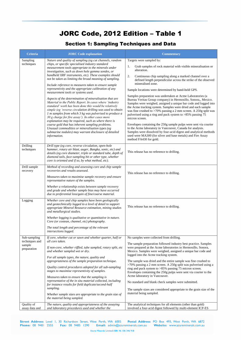
APPENDIX 1
Table 1: Assay results from sampling of old mine workings at La Morita and San Simon
LOCATION SAMPLE NUMBER
SAMPLE TYPE
SAMPLE LENGTH
(m) EAST (mE)
NORTH (mN)
ELEVATION (mASL)
GRADE
Cu ppm
Au g/t
Ag g/t
La Morita ALR-1026 Mine Dump Grab Not Applicable 571681.0 3413875.0 1403 11 0.005 <0.5
La Morita ALR-1027 Channel 2.7 571678.0 3413875.0 1402 50 0.031 0.7
La Morita ALR-1028 Channel 3.3 571675.5 3413877.5 1402 27 0.006 0.6
La Morita ALR-1029 Channel 2.3 571681.5 3413881.0 1404 14 <0.005 3
La Morita ALR-1030 Channel 3.3 571689.0 3413888.0 1405 15 0.011 1
La Morita ALR-1031 Channel 1.5 571649.0 3413852.0 1400 3491 0.016 0.8
La Morita ALR-1032 Channel 2.3 571652.0 3413850.0 1400 1066 <0.005 <0.5
La Morita ALR-1033 Channel 3.0 571621.0 3413840.0 1397 116 <0.005 <0.5
La Morita ALR-1034 Channel 2.0 571622.5 3413819.0 1395 25 <0.005 <0.5
La Morita ALR-1035 Channel 1.7 571627.0 3413815.0 1395 52 <0.005 <0.5
La Morita ALR-1036 Channel 3.5 571762.0 3413839.0 1404 138 0.01 6.1
La Morita ALR-1037 Mine Dump Channel 5.0 571897.0 3413924.0 1412 3027 0.06 4.4
La Morita ALR-1038 Rock Chip 4.8 572055.5 3413774.5 1412 12620 0.009 0.7
La Morita ALR-1039 Channel 2.2 571956.0 3413874.0 1412 6399 0.024 0.6

Table 1 (Cont.): Assay results from sampling of old mine workings at La Morita and San Simon
La Morita ALR-1040 Channel 2.1 571960.0 3413870.0 1412 8699 0.006 <0.5
La Morita ALR-1041 Channel 2.8 571973.0 3413857.0 1412 2018 0.019 1.7
La Morita ALR-1042 Channel 2.2 572010.0 3413819.0 1412 4475 <0.005 0.6
La Morita ALR-1043 Channel 4.0 572011.0 3413768.0 1412 3249 0.023 1.4
La Morita ALR-1044 Channel 2.0 571862.0 3413774.0 1456 372 0.005 <0.5
La Morita ALR-1045 Channel 5.5 571872.0 3413755.0 1468 72 0.006 <0.5
La Morita ALR-1046 Channel 5.2 571877.0 3413778.0 1469 92 <0.005 0.5
La Morita ALR-1047 Rock Chip 5.0 571935.0 3413716.0 1496 163 0.008 <0.5
La Morita ALR-1048 Mine Dump Grab Not Applicable 572145.0 3413706.0 1530 11290 0.257 159.6
La Morita ALR-1049 Rock Chip 7.0 572154.0 3413710.0 1531 292 0.026 4.3
La Morita ALR-1050 Channel 3.0 571516.0 3414429.0 1576 9 <0.005 1
La Morita ALR-1051 Channel 1.5 571703.0 3413830.0 1404 239 0.006 1.4
La Morita ALR-1052 Channel 3.3 572074.5 3413756.0 1412 3086 0.011 0.8
La Morita ALR-1053 Channel 4.2 572080.0 3413731.0 1412 5458 0.009 3.4
La Morita ALR-1054 Channel 2.0 572059.0 3413757.5 1412 7716 0.01 <0.5
La Morita ALR-1055 Channel 1.5 572068.5 3413772.0 1412 13200 0.037 4.9
La Morita ALR-1056 Channel 1.35 572066.0 3413789.0 1412 14120 0.011 <0.5
La Morita ALR-1057 Channel 1.3 571943.0 3413887.5 1412 2919 0.009 0.6
La Morita ALR-1058 Channel 1.6 571941.0 3413887.0 1412 3195 0.01 <0.5
La Morita ALR-1059 Channel 3.7 572258.0 3414752.0 1522 100 <0.005 2.2
La Morita ALR-1060 Channel 1.8 571560.0 3413431.0 1503 53600 0.013 <0.5
La Morita ALR-1061 Channel 2.2 571561.5 3413429.0 1502 2195 0.006 0.8
La Morita ALR-1062 Channel 3.8 571567.0 3413427.0 1504 2521 0.008 <0.5
La Morita ALR-1063 Mine Dump Grab Not Applicable 571557.0 3413422.0 1501 53940 0.009 1.5
La Morita ALR-1064 Channel 0.8 571577.0 3413434.0 1509 6463 <0.005 <0.5
La Morita ALR-1065 Channel 2.3 571584.0 3413428.5 1505 1901 0.029 <0.5
San Simon ALR-1066 Channel 1.4 573129.5 3414505.0 1617 1527 2.611 192.0
San Simon ALR-1067 Channel 1.35 573126.5 3414505.0 1617 287 0.119 39.8
San Simon ALR-1068 Channel 1.8 573123.0 3414503.5 1617 606 0.07 22.5
San Simon ALR-1069 Mine Dump Grab Not Applicable 573129.0 3414503.0 1622 78740 1.974 99.5
San Simon ALR-1070 Channel 1.8 573122.5 3414494.5 1588 112 0.503 42.8
San Simon ALR-1071 Channel 1.7 573145.0 3414495.5 1588 166 1.578 272.0
NB: Highlighted samples returned assays greater than 0.5% Cu and/or 1.0g/t Au and/or 60g/t Ag
JORC Code, 2012 Edition – Table 1
Section 1: Sampling Techniques and Data
Criteria JORC Code explanation Commentary
Sampling
techniques
Nature and quality of sampling (eg cut channels, random
chips, or specific specialised industry standard measurement tools appropriate to the minerals under
investigation, such as down hole gamma sondes, or
handheld XRF instruments, etc). These examples should not be taken as limiting the broad meaning of sampling.
Include reference to measures taken to ensure sample
representivity and the appropriate calibration of any measurement tools or systems used.
Aspects of the determination of mineralisation that are
Material to the Public Report. In cases where ‘industry standard’ work has been done this would be relatively
simple (eg ‘reverse circulation drilling was used to obtain
1 m samples from which 3 kg was pulverised to produce a 30 g charge for fire assay’). In other cases more
explanation may be required, such as where there is
coarse gold that has inherent sampling problems. Unusual commodities or mineralisation types (eg
submarine nodules) may warrant disclosure of detailed
information.
Targets were sampled by:
1. Grab samples of rock material with visible mineralisation or alteration.
2. Continuous chip sampling along a marked channel over a
defined length perpendicular across the strike of the observed mineralised zone.
Sample locations were determined by hand-held GPS.
Samples preparation was undertaken at Acme Laboratories (a Bureau Veritas Group company) in Hermosillo, Sonora,, Mexico.
Samples were weighed, assigned a unique bar code and logged into
the Acme tracking system. Samples were dried and each sample was fine crushed to >70% passing a 2 mm screen. A 250g split was
pulverised using a ring and puck system to >85% passing 75
micron screen.
Envelopes containing the 250g sample pulps were sent via courier
to the Acme laboratory in Vancouver, Canada for analysis.
Samples were dissolved by four-acid digest and analytical methods used were MA300 (for silver and base metals) and Fire Assay
method FA430 for gold.
Drilling techniques
Drill type (eg core, reverse circulation, open-hole hammer, rotary air blast, auger, Bangka, sonic, etc) and
details (eg core diameter, triple or standard tube, depth of
diamond tails, face-sampling bit or other type, whether core is oriented and if so, by what method, etc).
This release has no reference to drilling.
Drill sample
recovery
Method of recording and assessing core and chip sample
recoveries and results assessed.
Measures taken to maximise sample recovery and ensure representative nature of the samples.
Whether a relationship exists between sample recovery
and grade and whether sample bias may have occurred due to preferential loss/gain of fine/coarse material.
This release has no reference to drilling.
Logging Whether core and chip samples have been geologically
and geotechnically logged to a level of detail to support appropriate Mineral Resource estimation, mining studies
and metallurgical studies.
Whether logging is qualitative or quantitative in nature. Core (or costean, channel, etc) photography.
The total length and percentage of the relevant
intersections logged.
This release has no reference to drilling.
Sub-sampling
techniques and
sample preparation
If core, whether cut or sawn and whether quarter, half or
all core taken.
If non-core, whether riffled, tube sampled, rotary split, etc and whether sampled wet or dry.
For all sample types, the nature, quality and
appropriateness of the sample preparation technique.
Quality control procedures adopted for all sub-sampling
stages to maximise representivity of samples.
Measures taken to ensure that the sampling is representative of the in situ material collected, including
for instance results for field duplicate/second-half
sampling.
Whether sample sizes are appropriate to the grain size of
the material being sampled.
No samples were collected from drilling.
The sample preparation followed industry best practice. Samples
were prepared at the Acme laboratories in Hermosillo, Sonora, Mexico. Samples were weighed, assigned a unique bar code and
logged into the Acme tracking system.
The sample was dried and the entire sample was fine crushed to >70% passing a 2 mm screen. A 250g split was pulverised using a
ring and puck system to >85% passing 75 micron screen.
Envelopes containing the 250g pulps were sent via courier to the Acme laboratory in Vancouver.
No standard and blank check samples were submitted.
The sample sizes are considered appropriate to the grain size of the
material being sampled.
Quality of
assay data and
The nature, quality and appropriateness of the assaying
and laboratory procedures used and whether the
The analytical techniques for all elements (other than gold)
involved a four-acid digest followed by multi-element ICP-ES

Laboratory
tests
technique is considered partial or total.
For geophysical tools, spectrometers, handheld XRF instruments, etc, the parameters used in determining the
analysis including instrument make and model, reading
times, calibrations factors applied and their derivation, etc.
Nature of quality control procedures adopted (eg
standards, blanks, duplicates, external laboratory checks) and whether acceptable levels of accuracy (ie lack of
bias) and precision have been established.
analysis. This technique is considered a total digest for all relevant
minerals.
No geophysical or portable analysis tools were used to determine
assay values.
Internal laboratory control procedures comprised duplicate
sampling of randomly selected assay pulps, as well as internal laboratory standards and blanks.
Verification of
sampling and assaying
The verification of significant intersections by either
independent or alternative company personnel.
The use of twinned holes.
Documentation of primary data, data entry procedures,
data verification, data storage (physical and electronic) protocols.
Discuss any adjustment to assay data.
Senior technical personnel from the Company (Project Geologists
and Exploration Manager) inspected the samples.
No drilling was undertaken.
Primary data was collected by employees of the Company at the
project site. All measurements and observations were recorded
onto hard copy templates and later transcribed into the Company’s digital database.
Digital data storage, verification and validation are managed by an
independent data management company.
No adjustments or calibrations have been made to any assay data.
Location of
data points
Accuracy and quality of surveys used to locate drill holes
(collar and down-hole surveys), trenches, mine workings
and other locations used in Mineral Resource estimation.
Specification of the grid system used.
Quality and adequacy of topographic control.
Sample locations were determined by hand-held GPS.
The grid system used is NAD27 Mexico UTM Zone 12 for easting,
northing and RL.
Data spacing and distribution
Data spacing for reporting of Exploration Results.
Whether the data spacing and distribution is sufficient to
establish the degree of geological and grade continuity
appropriate for the Mineral Resource and Ore Reserve estimation procedure(s) and classifications applied.
Whether sample compositing has been applied.
Samples were collected on the basis of visual recognition of alteration or mineralisation. Sample spacing was not relevant as
this was a reconnaissance program.
Data spacing and distribution is insufficient to establish the degree of geological and grade continuity appropriate for Mineral
Resource and Ore Reserve estimation procedures.
No composite samples were collected.
Orientation of
data in relation
to geological
structure
Whether the orientation of sampling achieves unbiased sampling of possible structures and the extent to which
this is known, considering the deposit type.
If the relationship between the drilling orientation and the orientation of key mineralised structures is considered to
have introduced a sampling bias, this should be assessed
and reported if material.
Geological controls and orientations of the mineralised zone are
unknown at this time and it is not possible to determination
potential sampling bias.
Sample
security
The measures taken to ensure sample security. Assay samples were placed in poly sample bags, each with a
uniquely numbered ticket stub from a sample ticket book. Sample
bags were marked with the same sample number and sealed with a plastic cable tie. Samples were placed in woven polypropylene
“rice bags” and a numbered tamper-proof plastic cable tie was used
to close each bag. The rice bags were delivered by company personnel directly to the Acme laboratory for sample preparation.
The numbers on the seals were recorded for each shipment. Acme
audited the arriving samples and reported any discrepancies back to the Company. No such discrepancies occurred.
Audits or
reviews
The results of any audits or reviews of sampling
techniques and data.
All digital data is subject to audit by the independent data manager.

Section 2: Reporting of Exploration Results
Criteria JORC Code explanation Commentary
Mineral
tenement and land tenure
status
Type, reference name/number, location and ownership
including agreements or material issues with third parties such as joint ventures, partnerships, overriding
royalties, native title interests, historical sites, wilderness
or national park and environmental settings.
The security of the tenure held at the time of reporting
along with any known impediments to obtaining a licence
to operate in the area.
The Alacrán Project comprises 22 mineral concessions 100% owned by
Minera Teck SA de CV, a subsidiary of Teck Resources Limited.
Azure Minerals has an Option to acquire 100% ownership of these
concessions by spending US$5 million over four years, subject to Teck
having a one-off right to buy back up to 65% ownership.
A 2% Net Smelter Royalty is held by Grupo Mexico.
The tenements are secure and are in good standing. There are no known
impediments to obtaining a licence to operate in the area.
Exploration
done by other
parties
Acknowledgment and appraisal of exploration by other
parties.
The project area has a history of industrial-scale commercial mining and
small-scale artisanal mining dating back to the early 20th century, which ended
shortly after the start of the Mexican Revolution in 1910. After the Revolution
ended in the 1920’s, the property was explored intermittently.
The Anaconda Copper Mining Company is known to have done some
exploration, including drilling, on the property prior to the late 1960’s. Data relating to this work has been located but has yet to be reviewed.
Between 1969 and the early 1980’s, the Consejo de Recursos Minerales
(Mexican Geological Survey) carried out occasional exploration programs, including drilling 6 holes in 1970 and undertaking geophysical surveys over
the Palo Seco and La Morita prospects in 1981.
Grupo Mexico acquired the project after the CRM completed their drilling. Grupo Mexico drilled an additional 26 holes on the project in two phases.
The first phase was done in 1991 (24 holes) and the second phase was done in
1997 and 1998 (two holes).
Minera Teck S.A. de C.V., a Mexican subsidiary of Teck Resources Limited
acquired the property in 2013 and undertook limited surface exploration.
Azure Minerals acquired the rights to the project in December 2014 through its fully owned Mexican subsidiary company Minera Piedra Azul SA de CV.
Geology Deposit type, geological setting and style of
mineralisation.
Various styles of mineralisation occur on the property.
Intermediate sulphidation epithermal veins and stockworks host silver, lead, zinc, copper and gold in Cretaceous volcaniclastic rocks (the La Morita, Palo
Seco and Alacrán mines).
Secondary copper oxide and chalcocite mineralisation occur in volcanic rocks.
Primary copper mineralization is hosted in porphyry rocks.
Drill hole
information
A summary of all information material to the
understanding of the exploration results including a tabulation of the following information for all Material
Refer to tables in the report and notes attached thereto which provide all
relevant details.

drill holes:
easting and northing of the drill hole collar
elevation or RL (Reduced Level – elevation above sea level in metres) of the drill hole collar
dip and azimuth of the hole
down hole length and interception depth
hole length.
If the exclusion of this information is justified on the
basis that the information is not Material and this exclusion does not detract from the understanding of the
report, the Competent Person should clearly explain why this is the case.
Data
aggregation
methods
In reporting Exploration Results, weighting averaging
techniques, maximum and/or minimum grade truncations
(eg cutting of high grades) and cut-off grades are usually Material and should be stated.
Where aggregate intercepts incorporate short lengths of
high grade results and longer lengths of low grade results, the procedure used for such aggregation should
be stated and some typical examples of such
aggregations should be shown in detail.
The assumptions used for any reporting of metal
equivalent values should be clearly stated.
No weighting averaging techniques, maximum and/or minimum grade
truncations (eg cutting of high grades) or cut-off grades were applied.
No metal equivalency values or factors have been used.
Relationship between
mineralisation
widths and intercept lengths
These relationships are particularly important in the reporting of Exploration Results. If the geometry of the
mineralisation with respect to the drill hole angle is
known, its nature should be reported. If it is not known and only the down hole lengths are reported, there
should be a clear statement to this effect (e.g. ‘down hole
length, true width not known’).
Geological controls and orientations of the mineralised zone are unknown at this time.
Diagrams Appropriate maps and sections (with scales) and tabulations of intercepts should be included for any
significant discovery being reported. These should
include, but not be limited to a plan view of drill hole collar locations and appropriate sectional views.
Refer to Figures in attached report
Balanced
reporting
Where comprehensive reporting of all Exploration
Results is not practicable, representative reporting of both low and high grades and/or widths should be
practiced to avoid misleading reporting of Exploration
Results.
The Company believes that the ASX announcement is a balanced report with
all material results reported.
Other
substantive
exploration data
Other exploration data, if meaningful and material,
should be reported including (but not limited to):
geological observations; geophysical survey results; geochemical survey results; bulk samples – size and
method of treatment; metallurgical test results; bulk
density, groundwater, geotechnical and rock characteristics; potential deleterious or contaminating
substances.
This announcement refers to previous exploration results including
geophysics, geochemistry and geology.
Further work The nature and scale of planned further work (e.g. tests
for lateral extensions or depth extensions or large-scale step-out drilling).
Diagrams clearly highlighting the areas of possible
extensions, including the main geological interpretations and future drilling areas, provided this information is not
commercially sensitive
Further work to better understand the mineralisation systems in the project
area is likely to comprise geological mapping, surface and underground sampling, geophysical surveys (IP and magnetics) and drilling.


![Morita theory for group corings - Semantic Scholar · The first Morita context was constructed by Chase and Sweedler [9], which was generalized by Doi [12]. Morita contexts similar](https://static.fdocuments.in/doc/165x107/6055620657f9b55ddf7d34b2/morita-theory-for-group-corings-semantic-scholar-the-irst-morita-context-was.jpg)


