Slope Instability Zoning Mapping of Landslide Hazardous ... · FS 4D - Landslide and Subsidence...
13
FS 4D - Landslide and Subsidence Monitoring II 1/13 Febri Hirnawan Slope Instability Zone Mapping of Landslide Hazardous Area for the Stabilization System (3991) FIG Congress 2010 Facing the Challenges – Building the Capacity Sydney, Australia, 11-16 April 2010 Slope Instability Zoning Mapping of Landslide Hazardous Area for The Stabilization System (3991) Febri HIRNAWAN, Indonesia Key words : slope instability zoning mapping, mitigation strategy, stabilization system, triggering factors SUMMARY This is a summary on the latest development of slope instability hazardous zoning mapping in Citanduy, and Cimanuk drainage basins, Eastern West Java, Indonesia, and the simulation to achieve slope stabilization system for the preparation of mitigation program using integrated role of slope geometry modification and optimal use of vegetation. Slope instability zones, for example in Citanduy drainage basins were mapped and discussed in this paper, which encompass four classes of zones of slope instability, known as zone of instable slopes, zone of instable to critical slopes, zone of critical slopes, and zone of stable slopes. Triggering factors in this river basin were studied, which shall be involved for simulation to achieve stabilized slopes in zones of instable slope. It is important to be carried out to prevent downstream side of this river basin from landslides. Upstream area is prone to landslide, which needs to be mitigated to achieve slope stabilization system using the abovementioned method. SUMMARY (Summary in Bahasa Indonesia) Ini adalah ichtisar tentang pengembangan mutakhir pemetaan zonasi bahaya ketidakstabilan lereng di wilayah aliran sungai Citanduy, dan Cimanuk, Jawa Barat bagian Timur, Indonesia, dan simulasi dalam mendapatkan system stabilisasi lereng untuk persiapan program mitigasi dengan cara modifikasi lereng dan penggunaan vegetasi secara optimal. Zonasi ketidakstabilan lereng, misalnya di Wilayah aliran Sungai Citanduy telah dipetakan yang didiskusikan di dalam makalah ini, yang terdiri atas empat kelas ketidak- stabilan lereng, yaitu zona lereng tidak stabil, zona lereng tidak stabil – kritis, zona lereng kritis, dan zona lereng stabil.Faktor-faktor pemicu di wilayah aliran sungai ini dipelajari yang akan dilibatkan untuk simulasi dalam mencapai lereng-lereng yang distabilkan di dalam zona lereng tidak stabil. Hal ini penting dilakukan untuk melindungi bagian hilir sungai ini dari longsoran. Wilayah hulu sungai ini memendam bahaya longsor, sehingga memerlukan upaya mitigasi melalui sistem stabilisasi lereng dengan menggunakan metode tersebut di atas.
-
Upload
doankhuong -
Category
Documents
-
view
218 -
download
0
Transcript of Slope Instability Zoning Mapping of Landslide Hazardous ... · FS 4D - Landslide and Subsidence...

FS 4D - Landslide and Subsidence Monitoring II 1/13 Febri Hirnawan Slope Instability Zone Mapping of Landslide Hazardous Area for the Stabilization System (3991) FIG Congress 2010 Facing the Challenges – Building the Capacity Sydney, Australia, 11-16 April 2010
Slope Instability Zoning Mapping of Landslide Hazardous Area for The Stabilization System (3991)
Febri HIRNAWAN, Indonesia
Key words : slope instability zoning mapping, mitigation strategy, stabilization system, triggering factors SUMMARY This is a summary on the latest development of slope instability hazardous zoning mapping in Citanduy, and Cimanuk drainage basins, Eastern West Java, Indonesia, and the simulation to achieve slope stabilization system for the preparation of mitigation program using integrated role of slope geometry modification and optimal use of vegetation. Slope instability zones, for example in Citanduy drainage basins were mapped and discussed in this paper, which encompass four classes of zones of slope instability, known as zone of instable slopes, zone of instable to critical slopes, zone of critical slopes, and zone of stable slopes. Triggering factors in this river basin were studied, which shall be involved for simulation to achieve stabilized slopes in zones of instable slope. It is important to be carried out to prevent downstream side of this river basin from landslides. Upstream area is prone to landslide, which needs to be mitigated to achieve slope stabilization system using the abovementioned method. SUMMARY (Summary in Bahasa Indonesia)
Ini adalah ichtisar tentang pengembangan mutakhir pemetaan zonasi bahaya ketidakstabilan lereng di wilayah aliran sungai Citanduy, dan Cimanuk, Jawa Barat bagian Timur, Indonesia, dan simulasi dalam mendapatkan system stabilisasi lereng untuk persiapan program mitigasi dengan cara modifikasi lereng dan penggunaan vegetasi secara optimal. Zonasi ketidakstabilan lereng, misalnya di Wilayah aliran Sungai Citanduy telah dipetakan yang didiskusikan di dalam makalah ini, yang terdiri atas empat kelas ketidak-stabilan lereng, yaitu zona lereng tidak stabil, zona lereng tidak stabil – kritis, zona lereng kritis, dan zona lereng stabil.Faktor-faktor pemicu di wilayah aliran sungai ini dipelajari yang akan dilibatkan untuk simulasi dalam mencapai lereng-lereng yang distabilkan di dalam zona lereng tidak stabil. Hal ini penting dilakukan untuk melindungi bagian hilir sungai ini dari longsoran. Wilayah hulu sungai ini memendam bahaya longsor, sehingga memerlukan upaya mitigasi melalui sistem stabilisasi lereng dengan menggunakan metode tersebut di atas.

FS 4D - Landslide and Subsidence Monitoring II 2/13 Febri Hirnawan Slope Instability Zone Mapping of Landslide Hazardous Area for the Stabilization System (3991) FIG Congress 2010 Facing the Challenges – Building the Capacity Sydney, Australia, 11-16 April 2010
Slope Instability Zoning Mapping of Landslide Hazardous Area for The Stabilization System (3991)
Febri HIRNAWAN, Indonesia
INTRODUCTION 1.1. Background West Java is well known as one of regions in Indonesia with many landslide hazardous places, in which many complete triggering factors occur. These best slope instability phenomena due to the complete triggering factors are very appropriate as instable systems for the study of slope instability, from which instable models can be understood very well that should be able to be stabilized through simulation. The results of the studies are very suitable for the support of the programs of landslide hazard disaster reduction in mitigation strategy through slope stabilization system using the positive effect of slope internal and external factors to raise slope stability.
This province as a part of Java island is located in the southern part of Indonesia. Java and the other islands of Sumatera, Bali, Lombok, Sumbawa, Flores, and Timor etc. are situated parallel to the subduction zone characterized by active tectonic movements with frequent earthquakes (Figure 1 and 2), for example Java earthquake on September 31th, 2009 of 7.3 Richter scale, which hit Tasikmalaya and Cianjur. Landslides happened at Cibinong Subdistrict in Cianjur Regency due to this earthquake.
Figure 1. The Tectonics Map of Indonesia and the Philippines
(Puspito, 2003 in Hirnawan, 2008)

FS 4D - Landslide and Subsidence Monitoring II 3/13 Febri Hirnawan Slope Instability Zone Mapping of Landslide Hazardous Area for the Stabilization System (3991) FIG Congress 2010 Facing the Challenges – Building the Capacity Sydney, Australia, 11-16 April 2010
In West Java Tertiary sediments of Lower Miocene to Pliocene ages of more than 6,000 meters thick consisting of several formations were uplifted generating folded mountains, intruded by plutonic rocks and followed by the occurrence of volcanoes, which are characterized by landslide prone areas or mass movements. In the last five years about 56 % of total landslides in Indonesia occurred in this province. Besides, climate of West Java is wet, represented by annual rainfall of about more than 3,000 mm. The type of climate being based on the result of analysis using Schmidt and Ferguson procedure (Tjasyono, 1986) of annual rain fall data from 1951 till 1976 is wet or B, with the mean wet months and dry months are 9.3 and 2.2, and the quotient Q is 0.236 which is in the interval of 0.143 < Q < 0.333 indicating class B (Hirnawan, 1993). It is well understood that West Java is prone to landslides due to the geological condition and the climate. Landslides are common in this province mainly because of the occurrence of the available respective factors : 1) thick expansive residual soils, 2) high annual rainfall, 3) high seismic coefficient due to earthquakes as the manifestations of neotectonics, 4) well stratified sediments, 5) deforestation, 6) inconsistency of mining practices.
Figure 2. Epicenters of earthquakes in Indonesia and the Philippines, about more than 450 times per year (Puspito, 2003 in Hirnawan, 2008)
FS 4D - Landslide and Subsidence Monitoring II 4/13 Febri Hirnawan Slope Instability Zone Mapping of Landslide Hazardous Area for the Stabilization System (3991) FIG Congress 2010 Facing the Challenges – Building the Capacity Sydney, Australia, 11-16 April 2010
1.2. Landslide Prone Areas in West Java Geologic environmental factors encompassing geology, climate and seismic activity in West Java, Indonesia, govern the slope stability of the hilly areas. The geology of eastern side of West Java is characterized by folded and faulted thick Tertiary sedimentary rock formations, of well statified claystone, sandstone, and calcareous sandstone beds intercalation of Upper Miocene to Lower Pliocene age. This faulted thick Tertiary sediments are intruded by many intrusions during the process of magmatism followed by volcanism generating thick Quaternary volcanic deposits. Soils originated from both weathered Tertiary sediments and the Quaternary volcanic deposits are expansive. The X-ray difractometry tests of the soil samples show that the soils consist of clay minerals, such as montmorillonite, haloysite and illite with an amount of plagioclase and quartz. The Tertiary sediments, for example, Halang formation as turbidied sediments was deposited in deep marine environment exceeding 3 kilometers deep. This sediment gravity flow (Martodjojo, 1984) predominantly consisting of grey marine claystone beds intercalated with sandstone and breccia beds is the parent rock body of the clay minerals. Montmorillonite is authigenically originated from grey marine claystone of the Halang Formation containing volcanic ash which was deposited in deep environment. At 10.000 feet deep the clay mineral tends to intercalate with illite due to high pressure of the overburden of thick sediments (Burst, 1959, Powers, 1959, and Weaver, 1959 in Gillot, 1968). The claystones of the Halang Formation from Cibiuk Hill containing 25.00 % montmorillonite and 31,25 % illite are swelling-shrinking clays. That is why, the hilly area of distribution of the soils is a mass-movement hazardous area. Besides, the residual soils originated from Quaternary volcanic breccia are also expansive which mainly consist of haloysite.
In eastern West Java neotectonic activity has been generating deformation patterns both in Tertiary sediments and the unconformable overlying Quaternary volcanic deposits. As the result of the tectonic activity, the statistics analysis of subbasins morphometry as tectonic geomorphology developing in these two rock units exhibit the same pattern, which suggests the significant and active tectonic movements in this region extending to Central Java (Hirnawan, 1997, 1998, 2000, 2007; Hirnawan, et al, 1998; Hirnawan & Muslim, 2006; Hirnawan, et al, 2007). Frequent earthquakes representing neotectonic activity are common in this region that trigger landslides, especially in the rainy seasons. The seismic coefficients at Jeruklegi derived from data from 1903 till 1987 according to formulae from Donovan (1973 in Dowrick, 1978), Esteva (1974 in Dowrick, 1978), and Resodihardjo (1985) are 0.091, 0.088, and 0.013 respectively. According to McGuire formula the seismic acceleration in the study area is 55 gal for every 100 years period (Ibrahim & Ahmad, 1992).
FS 4D - Landslide and Subsidence Monitoring II 5/13 Febri Hirnawan Slope Instability Zone Mapping of Landslide Hazardous Area for the Stabilization System (3991) FIG Congress 2010 Facing the Challenges – Building the Capacity Sydney, Australia, 11-16 April 2010
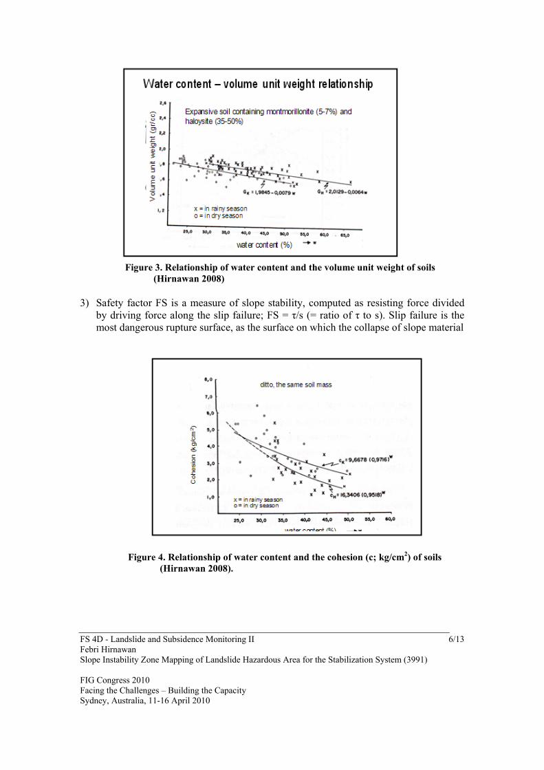
2. METHOD 2.1. Mapping of Slope Instability Zones Map exhibiting zones of stages of slope safety factors of a region is very important as the support of preparedness in mitigation strategy. This map should be prepared by delineating areas of distribution of about same slope stability to be grouped as a zone or a map unit. So, the same zone exhibits the same slope stability representing about the same range of values of safety factors . This mapping activity had been carried out both in Citanduy and Cimanuk drainage basins by the author and his team in West Java. As the results of the mapping, Map of Citanduy drainage basin, for example, presents the characteristics of the zones of slope stability I up to IV. 2.2. Simulation to Achieve Zone of Stable Slopes To understand the decrement of safety factor due to triggering factors that initiate landslide zone II as zone of instable to critical slope is taken as the object for simulation. This area is located in the upstream side of Citanduy river basin. In this area the soils of the hill slopes are weak and thick, and the available triggering factors are frequent earthquakes, high annual rain falls, and insufficient vegetation covers. These factors are adequate to be used for computing the existing safety factor of slopes and for testing the effects on slope stability to get the understanding of the slope instability phenomenon. Before simulation is conducted, understanding of the effect of triggering factors are presented below. 1) The effect of rainy season on soil strength and slope stability : Strength of soil mass
decreases in the rainy season, because the water content in the soil mass increases. These two variables exhibit the strong relationship between them indicated by high degree of correlation coefficient (Figure 3, 4, and 5).
2) The safety factor indicating slope stability is determined by strength properties of soil and/or rock masses that construct the slope body. The safety factor is a ratio of resisting moment (or shear strength) to driving moment (or shear stress) occurring in the body of slope due to the effect of gravitational force; these values of the two moments are determined by the strength of soil mass.
FS 4D - Landslide and Subsidence Monitoring II 6/13 Febri Hirnawan Slope Instability Zone Mapping of Landslide Hazardous Area for the Stabilization System (3991) FIG Congress 2010 Facing the Challenges – Building the Capacity Sydney, Australia, 11-16 April 2010
Figure 3. Relationship of water content and the volume unit weight of soils (Hirnawan 2008) 3) Safety factor FS is a measure of slope stability, computed as resisting force divided
by driving force along the slip failure; FS = τ/s (= ratio of τ to s). Slip failure is the most dangerous rupture surface, as the surface on which the collapse of slope material
Figure 4. Relationship of water content and the cohesion (c; kg/cm2) of soils (Hirnawan 2008).

FS 4D - Landslide and Subsidence Monitoring II 7/13 Febri Hirnawan Slope Instability Zone Mapping of Landslide Hazardous Area for the Stabilization System (3991) FIG Congress 2010 Facing the Challenges – Building the Capacity Sydney, Australia, 11-16 April 2010
Figure 5. Relationship of water content and the internal friction angle (φ;o) of soils (Hirnawan 2008)
moves downward. Resisting force τ is shear strength, which is generated by weight and strength properties of soil mass (cohesion c and internal friction angle φ) above slip failure to resist driving force. Driving force s is shear stress, generated by unit weight of soil mass γwet, which tend to slip the soil mass due to this force. It is understood that slope instability occur in the rainy season because the strength of soil mass decreases due to increasing water content. Slope stability under seismic loading is lowered by the increasing shear stress along slip surface, while the decreasing shear strength of the rock or soil mass is generated.
3. RESULT AND DISCUSSION 3.1. Map of slope instability This mapping activity had been carried out by the author and his team in West Java. As the results of the mapping, Map of Citanduy drainage basin, for example, presents the characteristics of the zones of slope stability I up to IV. The result of mapping of slope instability zones both in Citanduy and Cimanuk drainage basins is represented by Citanduy drainage basin in Figure 6.

FS 4D - Landslide and Subsidence Monitoring II 7/13 Febri Hirnawan Slope Instability Zone Mapping of Landslide Hazardous Area for the Stabilization System (3991) FIG Congress 2010 Facing the Challenges – Building the Capacity Sydney, Australia, 11-16 April 2010
Figure 6. Map of slope instability zones of Citanduy drainage basin, West Java
The zones are as follows : Zone I is a zone of unstable slopes, where slopes are in process of sliding. In this zone landslides are common. This zone is a landslide hazardous area which is characterized by frequent landslides. Old and new landslides occur here, in which growth of vegetation is not in a normal state but slant at an angle to the valley or to the summit of hills due to translational or rotational landslide respectively, indicating that the process of creeping or sliding is under way. This zone should be stabilized and conserved for better prevention of landslides. If necessary this zone should be abandoned and the people living here should be evacuated. Zone II is a zone of unstable to critical slopes in which landslides are from less than common to rare. The soils which construct the slopes of hills here are thick and weak enough and easily collapse when wet in rainy seasons. This zone should also be stabilized using adequate vegetation covers. Simulation to achieve bare stable slopes is needed before reforestation program is undertaken. Zone III is a zone of critical slopes. In this zone landslides are not common but still be able to happen, mainly when being triggered by a dense rain in a long time and earthquake simultaneously. Reforestation for better prevention of landslides in this zone can be carried out without being preceded by simulation, because stability of slopes in this zone is sufficient. Vegetation covers maintain the slopes to remain stable.

FS 4D - Landslide and Subsidence Monitoring II 8/13 Febri Hirnawan Slope Instability Zone Mapping of Landslide Hazardous Area for the Stabilization System (3991) FIG Congress 2010 Facing the Challenges – Building the Capacity Sydney, Australia, 11-16 April 2010
Zone IV is a zone of stable slopes. Here landslides are not found indicated by growth of vegetation in a normal sate. This zone is a very gentle slope area or level area. 3.2. The effect of earthquake on slope stability It is not easy to predict if a slope shall collapse because of earthquake. In general, a low safety factor of a slope shall be lower at earthquake condition and the slope shall be collapse. But, in the field from many low safety factors of slopes ranging from 1,07 to 1,25 (critical slopes) only several slopes collapse because of earthquake. Sometimes, the collapsed slope is not of the lowest initial safety factor. This phenomenon is interesting. Several cases exhibit this occurrence as shown in Table 1. 3.3. The effect of rainy season and earthquake on slope stability The effects of rainy season and earthquake, for example, at seismic coefficient hor = 0.10 on slope stability of Cibiuk Hill significantly reduced the mean safety factor, from FS = 1.4333 (stable) to FS = 1.0583 (instable) or decreased by 26 % at which landslides occurred.
Table 1. Result of simulation of the effect of earthquake in rainy season on Fs of slope profile GS2-GS1 with decreasing angle of slope, with entirely planted vegetation at slope face
FS 4D - Landslide and Subsidence Monitoring II 9/13 Febri Hirnawan Slope Instability Zone Mapping of Landslide Hazardous Area for the Stabilization System (3991) FIG Congress 2010 Facing the Challenges – Building the Capacity Sydney, Australia, 11-16 April 2010
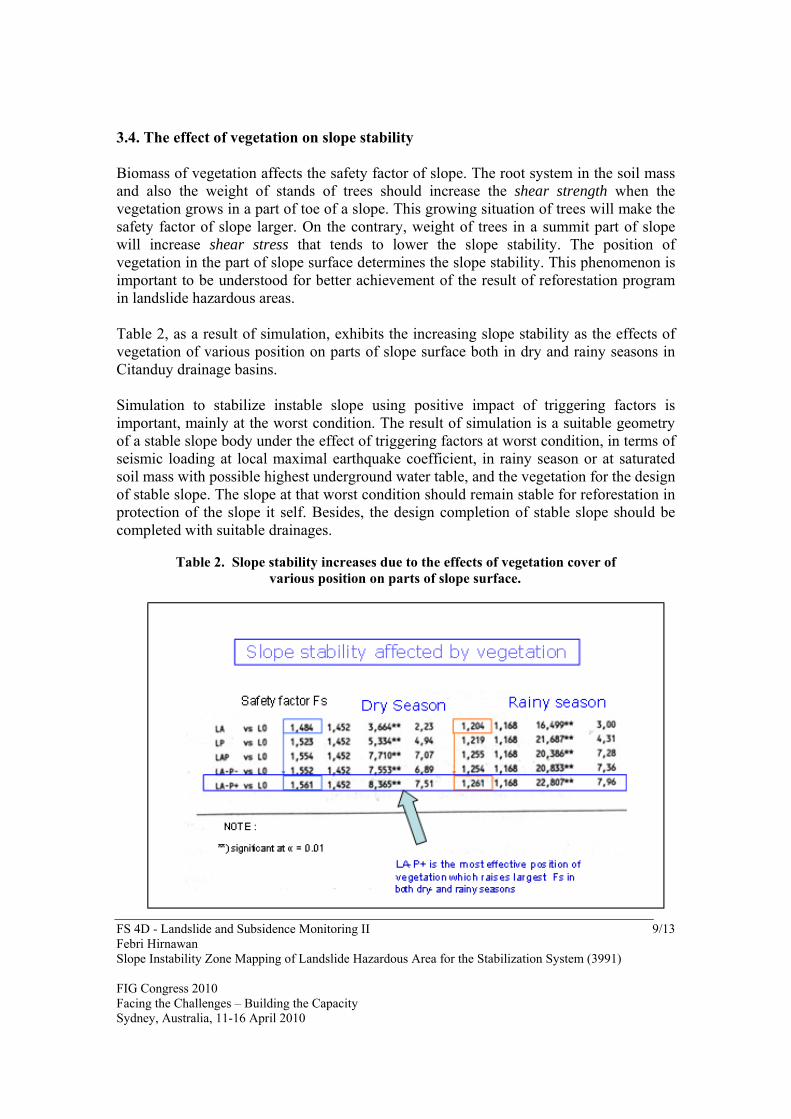
3.4. The effect of vegetation on slope stability Biomass of vegetation affects the safety factor of slope. The root system in the soil mass and also the weight of stands of trees should increase the shear strength when the vegetation grows in a part of toe of a slope. This growing situation of trees will make the safety factor of slope larger. On the contrary, weight of trees in a summit part of slope will increase shear stress that tends to lower the slope stability. The position of vegetation in the part of slope surface determines the slope stability. This phenomenon is important to be understood for better achievement of the result of reforestation program in landslide hazardous areas. Table 2, as a result of simulation, exhibits the increasing slope stability as the effects of vegetation of various position on parts of slope surface both in dry and rainy seasons in Citanduy drainage basins. Simulation to stabilize instable slope using positive impact of triggering factors is important, mainly at the worst condition. The result of simulation is a suitable geometry of a stable slope body under the effect of triggering factors at worst condition, in terms of seismic loading at local maximal earthquake coefficient, in rainy season or at saturated soil mass with possible highest underground water table, and the vegetation for the design of stable slope. The slope at that worst condition should remain stable for reforestation in protection of the slope it self. Besides, the design completion of stable slope should be completed with suitable drainages.
Table 2. Slope stability increases due to the effects of vegetation cover of
various position on parts of slope surface.

FS 4D - Landslide and Subsidence Monitoring II 10/13 Febri Hirnawan Slope Instability Zone Mapping of Landslide Hazardous Area for the Stabilization System (3991) FIG Congress 2010 Facing the Challenges – Building the Capacity Sydney, Australia, 11-16 April 2010
This simulation is very important to be executed to achieve the design criteria as a basis for the geotechnical design of a slope stabilization system through holistic approach using vegetation as a reinforcement factor in a worst condition in terms of saturated slope materials constructing the slope in rainy season under earthquake loading condition.
4. CONCLUSION
Triggering factors that initiate landslide encompass rainy season, earthquakes, deforestation, and changes of slope geometry due to excavation etc. Slope instability occurs prior to landslide due to the effects of these triggering factors. In west Java of unvaforable geological condition the triggering factors are completely encountered which generate landslides prone region. To stabilize the region intensive reforestation program being based on the results of this research is recommended, while the inconsistency of mining practices have to be prohibited.
REFERENCES
Dowrick, D. J., 1978, Earthquake resistant design, John wiley & Sons, Chickester. Gillot, J. E., 1968, Clay in engineering geology, Elsevier Pub. Co., Amsterdam, 296 pp. Hirnawan, Febri, 2000, Mass movement hazardous area of distribution of Halang
Formation, Bionatura – Padjadjaran Jour. of Life and Phys. Sci., Vol. 1, No. 2., February 2000, p. 103-114.
Hirnawan, Febri, 1997, Morphometry characteristics of drainage pattern in area of the
effect of active tectonic movements : System Analysis, No. 9, 1997, Technology Application and Study (BPPT), Jakarta, p. 67-77 *)
Hirnawan, Febri, 1998, Similarity of morphometry due to the effects of active tectonics
on the Cijolang and Cimuntur drainage basins in area of distribution of different lithology : Bulletin of Environmental Geology, No. 24, September, 1998, p. 19-27 *)
Hirnawan, F., Sudarsono, U., dan Soehaimi, A, 1998, Zoning of traced landslide hazards
damage zones of slope stability dynamic system and the stabilization by optimizing the integrated slope geometry modification and use of vegetation, Research &

FS 4D - Landslide and Subsidence Monitoring II 11/13 Febri Hirnawan Slope Instability Zone Mapping of Landslide Hazardous Area for the Stabilization System (3991) FIG Congress 2010 Facing the Challenges – Building the Capacity Sydney, Australia, 11-16 April 2010
Technology State Ministry Office, National Research Council, Report of Integrated Leading Research Program, 141 pp.*)
Hirnawan, Febri, 2007, Research, the running scientific process, Padjadjaran University
Press, 285 pp.*) Hirnawan, F., Agus Nur, A., Sophian, I., 2007, Response of Quaternary morphometry to
active tectonics as area constraint for spatial and infrastructure development program, Bumiayu, Central Java, Research Report, Research Institute, Padjadjaran University, 51 p.
Febri Hirnawan, 2008, West Java Natural Hazards Characteristics and Landslide
Prevention Technology; Discussion at Pikiran Rakyat Office, Bandung, 8 Januari 2008, unpublished
Ibrahim & Ahmad, M., 1992, Seismicity and its relation to the volcanics activity in
Indonesia, 2nd US – Asia Conference on Engineering for Mitigating Natural Hazards Damage, 22-26 June 19992, 142 pp.
Martodjojo, S., 1984, The evolution of the Bogor Sedimentary Basin, West Java,
unpublished Ph.D Thesis of Institute of Technology Bandung, 396 pp. *) Resodihardjo, S., 1985, Earthquakes and the acceleration in Indonesia, Communication &
Transportation Dept., Meteorology and Geophysics Board, Tangerang. *) Tjasyono, Bayong, 1987, Climate and environment, PT. Cendekia Jaya Utama, Bandung,
187 pp. *) *) in Indonesian with English Abstract BIOGRAPHICAL NOTES Febri Hirnawan was graduated from Ph.D. Program of Geosciences, University of Padjadjaran, Bandung, Indonesia in 1993 majoring in engineering geology. He was appointed as a professor in geology in 2000. He has been working as lecturer in Geology Department, Faculty of Mathematic and Natural Sciences since 1973. Since 2007 this department has been Faculty of Geological Sciences and Engineering. Since 1970 up to now he carried out hundreds of geological investigations and researches in many regions in Indonesia about engineering geology, geotechnics, tectonics, neotectonics, and areal development geology. He is a member of a famous Indonesia Association of Geologists (IAGI) in the country. He had published his papers in many journals of geosciences and

FS 4D - Landslide and Subsidence Monitoring II 12/13 Febri Hirnawan Slope Instability Zone Mapping of Landslide Hazardous Area for the Stabilization System (3991) FIG Congress 2010 Facing the Challenges – Building the Capacity Sydney, Australia, 11-16 April 2010
wrote few books. His technology invention in slope stabilization system had been patented and was presented before in 1995 IAMG (International Association for Mathematical Geology) Annual Conference in Osaka, Japan. Two other inventions of his about holistic valuation of terrain being based on genetic approach for spatial planning, and sand-column infiltration well (named GEOINFILTRANT) are being finalized in a substantive examination by patent office to achieve patents. CONTACT Febri Hirnawan University of Padjadjaran Post Graduate Program of Geoscience Faculty of Geosciences and Engineering Bandung 40264 Jawa Barat INDONESIA Tel.: + 62 22 730 4343 Fax: + 62 22 730 4343 Email: [email protected]