LANDSLIDE RISK MANAGEMENT AND SLOPE ENGINEERING IN …
40
The state-of-the-practice of geotechnical engineering in Taiwan and Hong Kong 97 LANDSLIDE RISK MANAGEMENT AND SLOPE ENGINEERING IN HONG KONG H.N. Wong & K.K.S. Ho Geotechnical Engineering Office, Civil Engineering and Development Department, Government of the Hong Kong Special Administrative Region Abstract: The slope safety problems faced by Hong Kong are the result of its dense urban development in a hilly terrain combined with high seasonal rainfall. The slope engineering practice and landslide risk management system in Hong Kong has evolved in response to experience and through continuous improvement initiatives. This has resulted in the progressive development of a slope safety regime aimed at reducing landslide risk to meet the needs of the public and facilitate sustainable developments. Hong Kong has pioneered the successful use of quantified landslide risk management in urban safety and disaster prevention. This is implemented by integrating quantitative risk assessment with slope engineering and landslide management. The key is to examine the likelihood and consequence of landslides, and thereby managing risk in totality. This paper presents the background to the development of risk-based landslide management in Hong Kong. Examples of application of quantitative risk assessment are given to illustrate how it serves to formulate the overall slope safety strategy and manage landslide risk posed by individual sites. EVOLUTION OF SLOPE ENGINEERING AND LANDSLIDE MANAGEMENT IN HONG KONG Hong Kong has a high concentration of developments on steep terrain in close proximity to man-made slopes and natural hillsides, which are susceptible to landsliding during heavy rain (Figure 1). These landslides can cause significant loss of life and socio-economical consequences, and they have been one of the most important issues in Hong Kong with regard to urban disaster prevention. The scale of the landslide problem is reflected by a death toll of over 470 people since the late 1940’s. This corresponded to a time when significant population growth commenced, which necessitated extensive civil engineering and building works, that were mostly implemented with the site formation works unregulated by government and with no expert geotechnical engineering input. Figure 1 - High concentration of developments in Hong Kong mingled with man-made slopes and natural hillsides
Transcript of LANDSLIDE RISK MANAGEMENT AND SLOPE ENGINEERING IN …

The state-of-the-practice of geotechnical engineering in Taiwan and Hong Kong 97
LANDSLIDE RISK MANAGEMENT
AND SLOPE ENGINEERING IN HONG KONG
H.N. Wong & K.K.S. Ho Geotechnical Engineering Office, Civil Engineering and Development Department,
Government of the Hong Kong Special Administrative Region Abstract: The slope safety problems faced by Hong Kong are the result of its dense urban
development in a hilly terrain combined with high seasonal rainfall. The slope engineering
practice and landslide risk management system in Hong Kong has evolved in response to
experience and through continuous improvement initiatives. This has resulted in the
progressive development of a slope safety regime aimed at reducing landslide risk to meet the
needs of the public and facilitate sustainable developments. Hong Kong has pioneered the
successful use of quantified landslide risk management in urban safety and disaster
prevention. This is implemented by integrating quantitative risk assessment with slope
engineering and landslide management. The key is to examine the likelihood and
consequence of landslides, and thereby managing risk in totality. This paper presents the
background to the development of risk-based landslide management in Hong Kong.
Examples of application of quantitative risk assessment are given to illustrate how it serves to
formulate the overall slope safety strategy and manage landslide risk posed by individual
sites.
EVOLUTION OF SLOPE ENGINEERING AND LANDSLIDE MANAGEMENT IN
HONG KONG
Hong Kong has a high concentration of developments on steep terrain in close proximity to man-made slopes and natural hillsides, which are susceptible to landsliding during heavy rain (Figure 1). These landslides can cause significant loss of life and socio-economical consequences, and they have been one of the most important issues in Hong Kong with regard to urban disaster prevention. The scale of the landslide problem is reflected by a death toll of over 470 people since the late 1940’s. This corresponded to a time when significant population growth commenced, which necessitated extensive civil engineering and building works, that were mostly implemented with the site formation works unregulated by government and with no expert geotechnical engineering input.
Figure 1 - High concentration of developments in Hong Kong mingled with man-made slopes
and natural hillsides
The state-of-the-practice of geotechnical engineering in Taiwan and Hong Kong 98
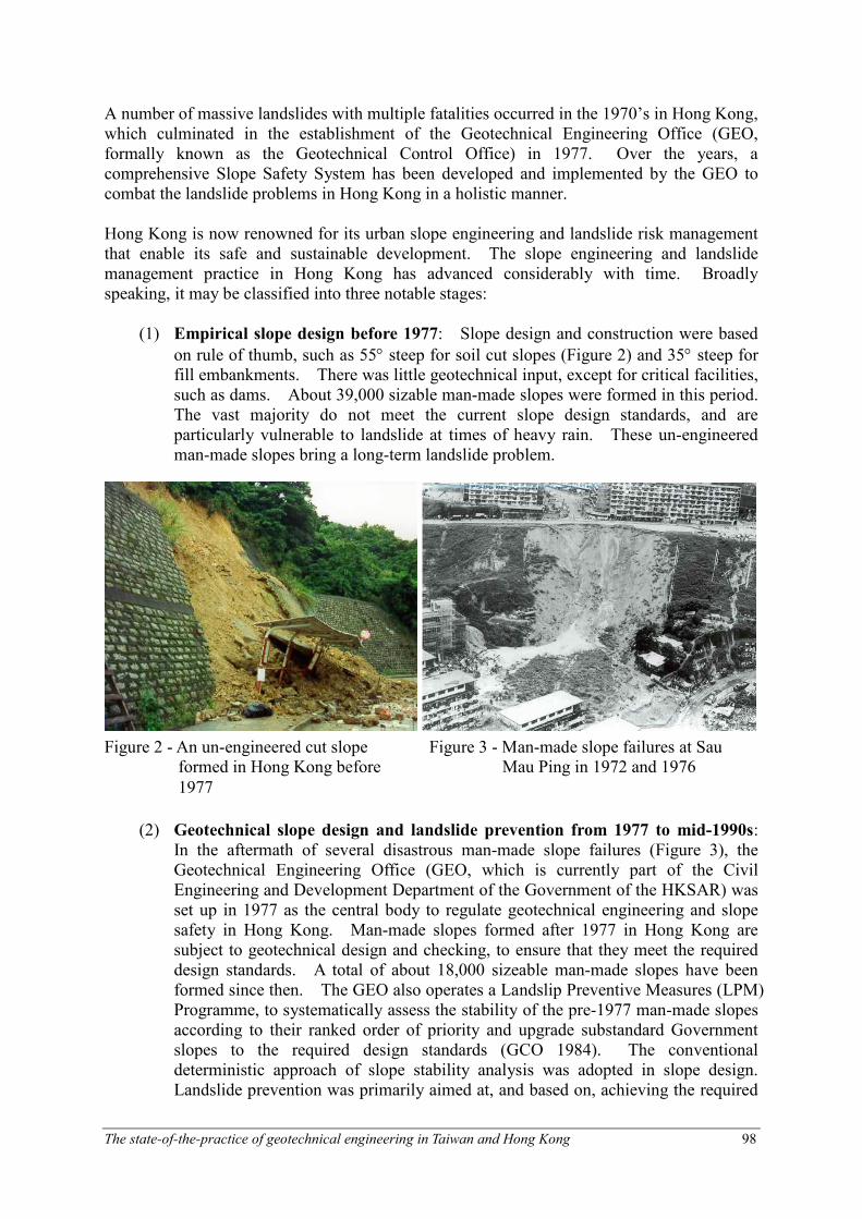
A number of massive landslides with multiple fatalities occurred in the 1970’s in Hong Kong, which culminated in the establishment of the Geotechnical Engineering Office (GEO, formally known as the Geotechnical Control Office) in 1977. Over the years, a comprehensive Slope Safety System has been developed and implemented by the GEO to combat the landslide problems in Hong Kong in a holistic manner. Hong Kong is now renowned for its urban slope engineering and landslide risk management that enable its safe and sustainable development. The slope engineering and landslide management practice in Hong Kong has advanced considerably with time. Broadly speaking, it may be classified into three notable stages:
(1) Empirical slope design before 1977: Slope design and construction were based
on rule of thumb, such as 55° steep for soil cut slopes (Figure 2) and 35° steep for fill embankments. There was little geotechnical input, except for critical facilities, such as dams. About 39,000 sizable man-made slopes were formed in this period. The vast majority do not meet the current slope design standards, and are particularly vulnerable to landslide at times of heavy rain. These un-engineered man-made slopes bring a long-term landslide problem.
(2) Geotechnical slope design and landslide prevention from 1977 to mid-1990s:
In the aftermath of several disastrous man-made slope failures (Figure 3), the Geotechnical Engineering Office (GEO, which is currently part of the Civil Engineering and Development Department of the Government of the HKSAR) was set up in 1977 as the central body to regulate geotechnical engineering and slope safety in Hong Kong. Man-made slopes formed after 1977 in Hong Kong are subject to geotechnical design and checking, to ensure that they meet the required design standards. A total of about 18,000 sizeable man-made slopes have been formed since then. The GEO also operates a Landslip Preventive Measures (LPM) Programme, to systematically assess the stability of the pre-1977 man-made slopes according to their ranked order of priority and upgrade substandard Government slopes to the required design standards (GCO 1984). The conventional deterministic approach of slope stability analysis was adopted in slope design. Landslide prevention was primarily aimed at, and based on, achieving the required
Figure 2 - An un-engineered cut slope formed in Hong Kong before
1977
Figure 3 - Man-made slope failures at Sau Mau Ping in 1972 and 1976
The state-of-the-practice of geotechnical engineering in Taiwan and Hong Kong 99
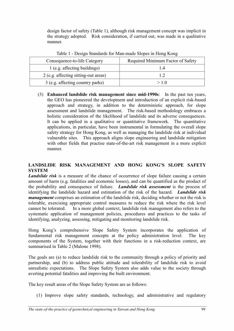
design factor of safety (Table 1), although risk management concept was implicit in the strategy adopted. Risk consideration, if carried out, was made in a qualitative manner.
Table 1 - Design Standards for Man-made Slopes in Hong Kong
Consequence-to-life Category Required Minimum Factor of Safety
1 (e.g. affecting buildings) 1.4
2 (e.g. affecting sitting-out areas) 1.2
3 (e.g. affecting country parks) > 1.0
(3) Enhanced landslide risk management since mid-1990s: In the past ten years,
the GEO has pioneered the development and introduction of an explicit risk-based approach and strategy, in addition to the deterministic approach, for slope assessment and landslide management. The risk-based methodology embraces a holistic consideration of the likelihood of landslide and its adverse consequences. It can be applied in a qualitative or quantitative framework. The quantitative applications, in particular, have been instrumental in formulating the overall slope safety strategy for Hong Kong, as well as managing the landslide risk at individual vulnerable sites. This approach aligns slope engineering and landslide mitigation with other fields that practise state-of-the-art risk management in a more explicit manner.
LANDSLIDE RISK MANAGEMENT AND HONG KONG’S SLOPE SAFETY
SYSTEM
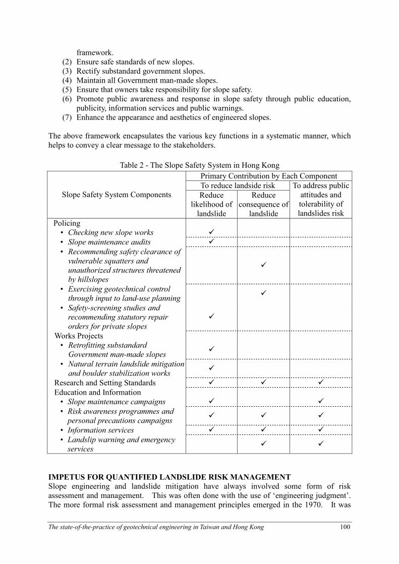
Landslide risk is a measure of the chance of occurrence of slope failure causing a certain amount of harm (e.g. fatalities and economic losses), and can be quantified as the product of the probability and consequence of failure. Landslide risk assessment is the process of identifying the landslide hazard and estimation of the risk of the hazard. Landslide risk management comprises an estimation of the landslide risk, deciding whether or not the risk is tolerable, exercising appropriate control measures to reduce the risk where the risk level cannot be tolerated. In a more global context, landslide risk management also refers to the systematic application of management policies, procedures and practices to the tasks of identifying, analyzing, assessing, mitigating and monitoring landslide risk. Hong Kong’s comprehensive Slope Safety System incorporates the application of fundamental risk management concepts at the policy administration level. The key components of the System, together with their functions in a risk-reduction context, are summarised in Table 2 (Malone 1998). The goals are (a) to reduce landslide risk to the community through a policy of priority and partnership, and (b) to address public attitude and tolerability of landslide risk to avoid unrealistic expectations. The Slope Safety System also adds value to the society through averting potential fatalities and improving the built environment. The key result areas of the Slope Safety System are as follows:
(1) Improve slope safety standards, technology, and administrative and regulatory
The state-of-the-practice of geotechnical engineering in Taiwan and Hong Kong 100
framework. (2) Ensure safe standards of new slopes. (3) Rectify substandard government slopes. (4) Maintain all Government man-made slopes. (5) Ensure that owners take responsibility for slope safety. (6) Promote public awareness and response in slope safety through public education,
publicity, information services and public warnings. (7) Enhance the appearance and aesthetics of engineered slopes.
The above framework encapsulates the various key functions in a systematic manner, which helps to convey a clear message to the stakeholders.
Table 2 - The Slope Safety System in Hong Kong
Primary Contribution by Each Component
To reduce landside risk Slope Safety System Components Reduce
likelihood of landslide
Reduce consequence of landslide
To address public attitudes and tolerability of landslides risk
Policing • Checking new slope works �
• Slope maintenance audits �
• Recommending safety clearance of
vulnerable squatters and
unauthorized structures threatened
by hillslopes
�
• Exercising geotechnical control
through input to land-use planning �
• Safety-screening studies and
recommending statutory repair
orders for private slopes
�
Works Projects • Retrofitting substandard
Government man-made slopes �
• Natural terrain landslide mitigation
and boulder stabilization works �
Research and Setting Standards � � �
Education and Information • Slope maintenance campaigns � �
• Risk awareness programmes and
personal precautions campaigns � � �
• Information services � � �
• Landslip warning and emergency
services � �
IMPETUS FOR QUANTIFIED LANDSLIDE RISK MANAGEMENT
Slope engineering and landslide mitigation have always involved some form of risk assessment and management. This was often done with the use of ‘engineering judgment’. The more formal risk assessment and management principles emerged in the 1970. It was

The state-of-the-practice of geotechnical engineering in Taiwan and Hong Kong 101
confined to qualitative applications in the early years, but has been extended into Quantitative Risk Assessment (QRA), particularly since the mid 1980s. In the early 1990s, risk management became well established in the hazardous industry as a process for handling risk to meet the expectation of the parties involved (Royal Society 1992). Since about the mid-1990s, QRA has been formally been applied in assessing and managing landslide risk, notably in Australia (AGS 2000), France (Leroi 1996) and Hong Kong (Wong et al. 1997). While the value of quantified landslide risk management is recognized by the geotechnical professionals and by many slope-related agencies and regulators, some are more advanced in its implementation than others. Hong Kong is a leading party in the development and application of quantified risk management, which brings about the following advances in slope engineering and landslide management:
(a) There are considerable uncertainties associated with the geological and groundwater conditions in the tropically weathered terrain in Hong Kong. These uncertainties are often difficult to be effectively addressed in a deterministic slope assessment. However, they can be analysed systematically and evaluated rationally using a quantified risk framework.
(b) The large number of potentially hazardous, old man-made slopes that await
retrofitting call for application of risk management techniques and principles to assess the scale of the problem, optimize resources allocation, prioritize follow-up action, and evaluate risk mitigation strategy.
(c) A risk-based approach facilitates communication of the nature and level of
landslide risk with the stakeholders including the general public. This is particularly important in Hong Kong as the public have a high expectation of slope safety and they want to be informed of the hazards that affect them.
(d) In the early years, the LPM Programme primarily dealt with large substandard
man-made slopes affecting occupied buildings. As many of these slopes have been upgraded, slopes of relatively smaller size or affecting different types of facilities are being processed under the Programme. Furthermore, increasing attention is required on mitigation of natural terrain landslide hazards affecting developed areas. QRA gives a structured framework for formulating a coherent landslide preventive strategy. It also provides a scientific basis for determining the risk management solutions at individual sites, particularly those affected by natural terrain landslide hazards, which cannot normally be effectively dealt with by conventional slope stabilization measures (Wong 2003).
Quantified landslide risk management is a novel technical development. Ho et al. (2000) described some notable issues and possible misconceptions in the use of QRA. A number of factors are essential to the progress made in formulation quantified landslide risk management methodology and pioneering its use in Hong Kong. These include: (a) Systematic landslide investigation and compilation of landslide records in Hong Kong (Wong and Ho 2000) have provided insight into the mechanisms and causes of landslides, as well as data for use in QRA.
(b) A series of technical development work undertaken by the GEO is instrumental to

The state-of-the-practice of geotechnical engineering in Taiwan and Hong Kong 102
Number of Fatalities, N
Frequency of N or more
Fatalities per Year, F
UNACCEPTABLE
formulating landslide QRA methodology (Wong 2001), e.g. assessment of landslide debris mobility (Wong and Ho 1996), quantification of landslide consequence (Wong et al. 1997), quantification of landslide frequency (Wong and Ho 1998), and formulation of natural terrain risk assessment methodology (Ng et al. 2002; Wong 2003).
(c) A set of landslide risk guidelines (ERM 1998), benchmarked against that adopted for Potentially Hazardous Installations in Hong Kong, has been formulated. The risk guidelines stipulate the tolerable risk criteria for natural terrain landslides in respect of both the Individual Risk and Societal Risk. The Individual Risk criteria apply to the annual probability of fatality for the most vulnerable person affected by the landslide hazard, and the maximum allowable limit is 10-5 in the case of a new development, and 10-4 for an existing development. The Societal Risk criteria apply to the total risk-to-life posed on the community by the landslide hazard, which is expressed as an F-N distribution (see Figure 4).
In implementing the Slope Safety System, quantified risk management is applied to the formulation of overall slope safety strategy and management of landslide risk posed by individual sites. These involve the use of global QRA and site-specific QRA respectively. The state-of-the-art of QRA applications, together with a review of the professional practice and development trends, is presented in Wong (2005). Three selected examples are given below to illustrate different types of application.
Global Risk Management for Landslides from Old Man-made Slopes
The GEO has compiled a comprehensive Catalogue of Slopes, which registers the 39,000 pre-1977 and 18,000 post-1977 man-made slopes. The overall risk of these slopes, in
Figure 4 - Societal Risk criteria adopted in Hong Kong for landslides
and boulder falls from natural terrain
The state-of-the-practice of geotechnical engineering in Taiwan and Hong Kong 103
terms of the annual potential loss of life (PLL) that may theoretically be caused by landslides from these slopes, was assessed in 1997, 2000 and 2004. The assessments serve to identify the scale of the landslide hazard, diagnose the risk distribution, formulate risk reduction strategy and targets for the LPM Programme, and monitor the progress of the risk reduction work. The methodology adopted in the above risk assessments was described in Wong and Ho (1998). The key findings are summarised below:
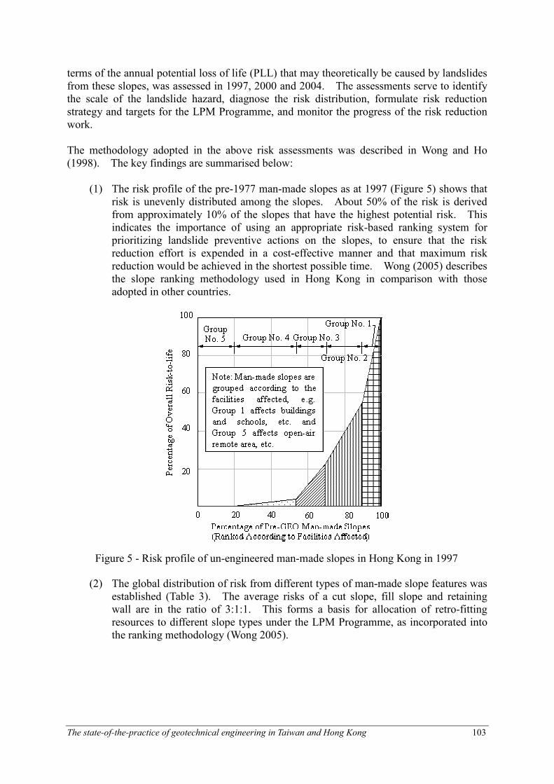
(1) The risk profile of the pre-1977 man-made slopes as at 1997 (Figure 5) shows that risk is unevenly distributed among the slopes. About 50% of the risk is derived from approximately 10% of the slopes that have the highest potential risk. This indicates the importance of using an appropriate risk-based ranking system for prioritizing landslide preventive actions on the slopes, to ensure that the risk reduction effort is expended in a cost-effective manner and that maximum risk reduction would be achieved in the shortest possible time. Wong (2005) describes the slope ranking methodology used in Hong Kong in comparison with those adopted in other countries.
(2) The global distribution of risk from different types of man-made slope features was established (Table 3). The average risks of a cut slope, fill slope and retaining wall are in the ratio of 3:1:1. This forms a basis for allocation of retro-fitting resources to different slope types under the LPM Programme, as incorporated into the ranking methodology (Wong 2005).
Figure 5 - Risk profile of un-engineered man-made slopes in Hong Kong in 1997
The state-of-the-practice of geotechnical engineering in Taiwan and Hong Kong 104
Table 3 - Risk distribution according to type of slope
Un-engineered Man-made Slopes before Year 1977 Slope Type
Cut Slopes Fill Slopes Retaining Walls
Percentage of Slopes 50% 25% 25%
Proportion of Total Risk 75% 13% 12%
Total Risk Ratio 6 1 1
Average Ratio of Risk per Feature 3 1 1
(3) The risk profile has been formally adopted as quantified risk reduction targets
pledged by the HKSAR Government. The LPM Programme was tasked to upgrade about 10% of the pre-1977 slopes by year 2000, and another 10% by 2010. The pledged reduction targets entail: (i) by the year 2000, the overall landslide risk from the pre-1977 slopes would be reduced to 50% of the level in 1977; (ii) by 2010, the risk would be further reduced to 25% of the level in 1977 (Works Bureau 1998).
(4) QRA has also been applied to evaluate and monitor the performance of the LPM
Programme. An assessment made in 2000 found that the risk of the pre-1977 slopes has reduced from 21.8 PLL/year in 1977 to 10.3 PLL/year in 2000, i.e. about 53% risk reduction was achieved (Cheung and Shiu 2000). An update of the assessment made in 2004 for progress monitoring indicated that the risk of the pre-1977 slopes would be further reduced to about 4 PLL/year by 2010 (Lo and Cheung 2004). At this rate of risk reduction, the Programme is operating at about HK$ 15 million per statistically life saved.
Site-specific Landslide Risk Management for Existing Buildings
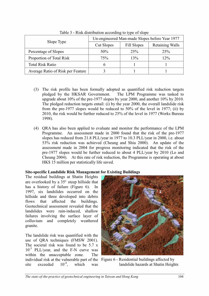
The residual buildings at Shatin Heights
are overlooked by a 35° steep hillside that has a history of failure (Figure 6). In 1997, six landslides occurred on the hillside and three developed into debris flows that affected the buildings. Geotechnical assessment revealed that the landslides were rain-induced, shallow failures involving the surface layer of colluvium and completely weathered granite. The landslide risk was quantified with the use of QRA techniques (FMSW 2001). The societal risk was found to be 5.7 x 10⁻³ PLL/year, and the F-N curve was within the unacceptable zone. The individual risk at the vulnerable part of the site exceeded 10-4, which was
Figure 6 - Residential buildings affected by
landslide hazards at Shatin Heights

The state-of-the-practice of geotechnical engineering in Taiwan and Hong Kong 105
(a) Before Risk Mitigation
IR ≥≥≥≥ 10- 4
IR < 10- 4
IR < 10- 5
(b) After Risk Mitigation
IR < 10- 4
IR < 10- 5
Note: IR = Individual Risk
(fatalities per year)
Figure 7 - Individual Risk at Shatin Heights
Before Risk Mitigation
After Risk
Mitigation
UNACCEPTABLE
Number of Fatalities, N
Frequency of N or more
Fatalities per Year, F
Figure 8 - Calculated F-N curves for Shatin Heights
unacceptable. These confirmed the need for risk mitigation in order to meet the prevailing risk standards. From an examination of the possible risk mitigation options, an optimal risk mitigation strategy was established. This included improvement of surface drainage and protection at the crest platform, provision of debris-resisting barriers and local slope stabilization. The cost of risk mitigation was about HK$ 6 million, which would result in mitigation of about 80% of the societal risk. After risk mitigation, the individual risk distribution (Figure 7) and F-N curve (Figure 8) would be well below the unacceptable zone. The risk mitigation was evaluated based on the As Low As Reasonably Practicable (ALARP) principle, and was found to be justified from risk-cost-benefit consideration. The risk mitigation works were completed in 2004.
The state-of-the-practice of geotechnical engineering in Taiwan and Hong Kong 106
Note: IR =
Individual
Risk (fatalities
per year)
Figure 10 - Individual Risk at planned buildings at Ling Pei
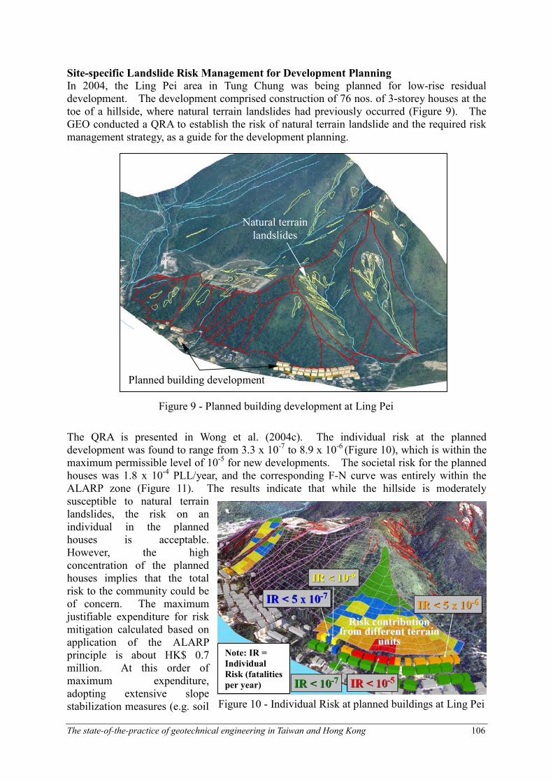
Site-specific Landslide Risk Management for Development Planning
In 2004, the Ling Pei area in Tung Chung was being planned for low-rise residual development. The development comprised construction of 76 nos. of 3-storey houses at the toe of a hillside, where natural terrain landslides had previously occurred (Figure 9). The GEO conducted a QRA to establish the risk of natural terrain landslide and the required risk management strategy, as a guide for the development planning.
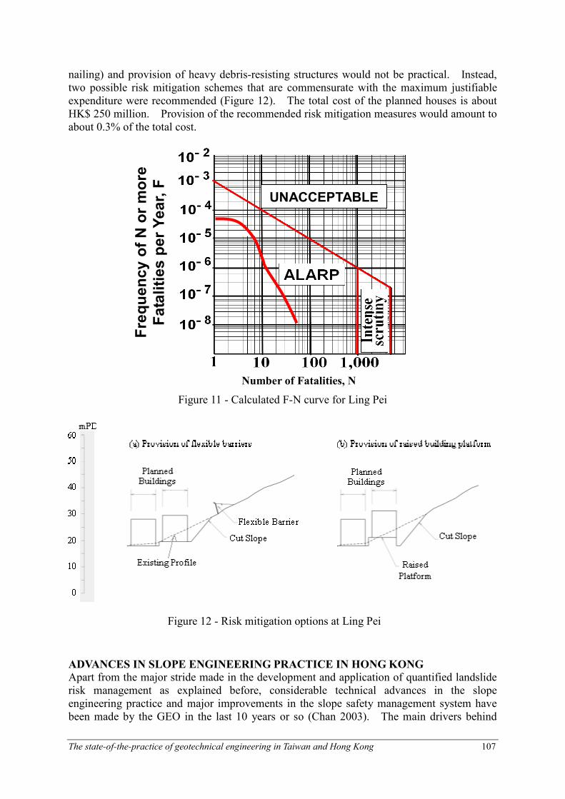
The QRA is presented in Wong et al. (2004c). The individual risk at the planned development was found to range from 3.3 x 10⁻⁷ to 8.9 x 10⁻⁶ (Figure 10), which is within the maximum permissible level of 10-5 for new developments. The societal risk for the planned houses was 1.8 x 10⁻⁴ PLL/year, and the corresponding F-N curve was entirely within the ALARP zone (Figure 11). The results indicate that while the hillside is moderately susceptible to natural terrain landslides, the risk on an individual in the planned houses is acceptable. However, the high concentration of the planned houses implies that the total risk to the community could be of concern. The maximum justifiable expenditure for risk mitigation calculated based on application of the ALARP principle is about HK$ 0.7 million. At this order of maximum expenditure, adopting extensive slope stabilization measures (e.g. soil
Planned building development
Natural terrain
landslides
Figure 9 - Planned building development at Ling Pei
The state-of-the-practice of geotechnical engineering in Taiwan and Hong Kong 107
Number of Fatalities, N
Frequency of N or more
Fatalities per Year, F
UNACCEPTABLE
Figure 11 - Calculated F-N curve for Ling Pei
nailing) and provision of heavy debris-resisting structures would not be practical. Instead, two possible risk mitigation schemes that are commensurate with the maximum justifiable expenditure were recommended (Figure 12). The total cost of the planned houses is about HK$ 250 million. Provision of the recommended risk mitigation measures would amount to about 0.3% of the total cost.
ADVANCES IN SLOPE ENGINEERING PRACTICE IN HONG KONG
Apart from the major stride made in the development and application of quantified landslide risk management as explained before, considerable technical advances in the slope engineering practice and major improvements in the slope safety management system have been made by the GEO in the last 10 years or so (Chan 2003). The main drivers behind
Figure 12 - Risk mitigation options at Ling Pei

The state-of-the-practice of geotechnical engineering in Taiwan and Hong Kong 108
Figure 13 - Automatic groundwater monitoring
Raingauge No.
these enhancements include the following: (a) the implementation of a systematic landslide investigation programme in the late 1990s to capture lessons learnt and insight from slope failures,
(b) continuing research and development work to advance the state-of-the-art in slope engineering (e.g. development and application of quantified risk management tools), and
(c) rising community expectations for improved slope aesthetics.
Some of the noteworthy enhancements are outlined below.
Improvement in Slope Investigation Practice
The practice in respect of ground investigations since the early 1980’s follows the standards promulgated by GCO (1987). Recent improvements in ground investigation practice are aimed at enhancing quality, efficiency and cost-effectiveness of slope investigation. Suitable portable triple-tube samplers, which can facilitate retrieval of undisturbed soil samples from depths down to about 6 m on sloping ground and from the bottom of trial pits, have been custom-made to combat access difficulties on hillslopes. Automatic groundwater monitoring systems, which can capture the critical piezometric data in a more reliable manner, have been successfully tested in field trials and are now in common use in Hong Kong (Figure 13). As a result of improvement in the reliability of instrumentation and wireless data transmission systems (e.g. use of radio waves), slopes can now be remotely and continually monitored in real time at affordable costs, which greatly facilitate a better understanding of the hydrogeology and the storm response of the piezometric heads during severe rainfalls.
The state-of-the-practice of geotechnical engineering in Taiwan and Hong Kong 109
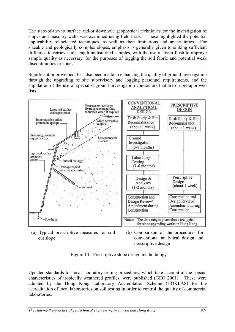
The state-of-the-art surface and/or downhole geophysical techniques for the investigation of slopes and masonry walls was examined using field trials. These highlighted the potential applicability of selected techniques, as well as their limitations and uncertainties. For sizeable and geologically complex slopes, emphasis is generally given to sinking sufficient drillholes to retrieve full-length undisturbed samples, with the use of foam flush to improve sample quality as necessary, for the purposes of logging the soil fabric and potential weak discontinuities or zones. Significant improvement has also been made in enhancing the quality of ground investigation through the upgrading of site supervisory and logging personnel requirements, and the stipulation of the use of specialist ground investigation contractors that are on pre-approved lists.
Updated standards for local laboratory testing procedures, which take account of the special characteristics of tropically weathered profiles, were published (GEO 2001). These were adopted by the Hong Kong Laboratory Accreditation Scheme (HOKLAS) for the accreditation of local laboratories on soil testing in order to control the quality of commercial laboratories.
(a) Typical prescriptive measures for soil
cut slope
(b) Comparison of the procedures for conventional analytical design and
prescriptive design
Figure 14 - Prescriptive slope design methodology

The state-of-the-practice of geotechnical engineering in Taiwan and Hong Kong 110
Note: N, L, Sh and other dimensions for the soil nails are given in Figure 15(b) based on the type of soil
nail layout specified by the designer.
(a) Layout
Alternative Prescriptive Design Approach for Slope Stability Improvement
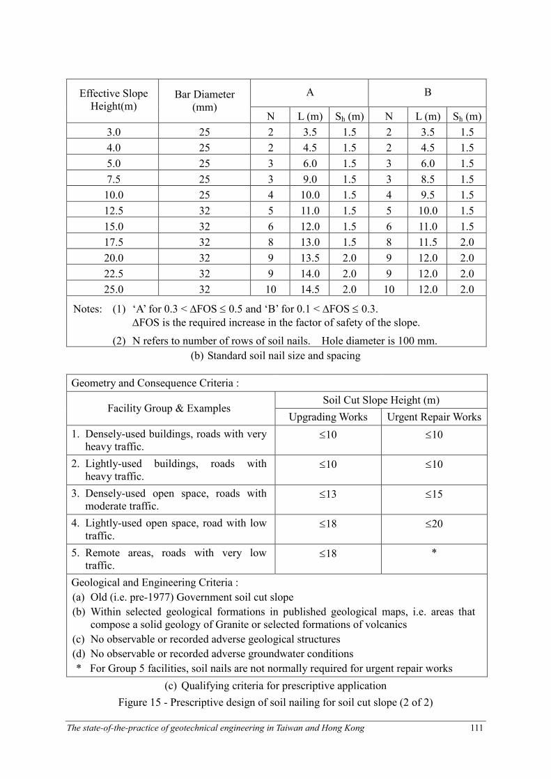
Guidance on slope assessment and design is given in the Geotechnical Manual for Slopes (GCO 1984), which has been widely adopted in local professional practice. The conventional analytical slope design is based on the formulation of a representative geological model, characterisation of the geotechnical properties of the geological materials, assessment of the appropriate design groundwater conditions and evaluation of slope stability condition based on the conventional limit equilibrium approach. Given a large number of smaller-sized, old substandard man-made slopes that require improvement, there is a need to bring about risk reduction in an efficient manner. An alternative prescriptive design methodology has therefore been developed to achieve significant savings in time and human resources. Prescriptive measures are pre-determined, experience-based and suitably conservative modules of works that are prescribed by qualified geotechnical professionals without the need for detailed ground investigation, laboratory testing and design analyses (see Figure 14). Details of the prescriptive design methodology are given by Wong et al. (1999). In order to ensure appropriate use of the proposed prescriptive design using soil nails for soil cuts (Figure 15), qualifying criteria have been defined for application to upgrading works and landslide repair works respectively. Prescriptive designs have also been developed for masonry and concrete retaining walls. Guidelines on the prescription of standardized modules of debris-resisting barriers have been published by Sun et al. (2003) for the mitigation of natural terrain landslide hazards. These standardized barriers incorporate tensioned steel mesh fences, and reinforced gabions and reinforced concrete barriers covering a design debris volume ranging from 50 m3 to 600 m3.
Figure 15 - Prescriptive design of soil nailing for soil cut slope (1 of 2)
The state-of-the-practice of geotechnical engineering in Taiwan and Hong Kong 111
A B Effective Slope Height(m)
Bar Diameter (mm)
N L (m) Sh (m) N L (m) Sh (m)
3.0 25 2 3.5 1.5 2 3.5 1.5
4.0 25 2 4.5 1.5 2 4.5 1.5
5.0 25 3 6.0 1.5 3 6.0 1.5
7.5 25 3 9.0 1.5 3 8.5 1.5
10.0 25 4 10.0 1.5 4 9.5 1.5
12.5 32 5 11.0 1.5 5 10.0 1.5
15.0 32 6 12.0 1.5 6 11.0 1.5
17.5 32 8 13.0 1.5 8 11.5 2.0
20.0 32 9 13.5 2.0 9 12.0 2.0
22.5 32 9 14.0 2.0 9 12.0 2.0
25.0 32 10 14.5 2.0 10 12.0 2.0
Notes: (1) ‘A’ for 0.3 < ∆FOS ≤ 0.5 and ‘B’ for 0.1 < ∆FOS ≤ 0.3.
∆FOS is the required increase in the factor of safety of the slope.
(2) N refers to number of rows of soil nails. Hole diameter is 100 mm.
(b) Standard soil nail size and spacing
Geometry and Consequence Criteria :
Soil Cut Slope Height (m) Facility Group & Examples
Upgrading Works Urgent Repair Works
1. Densely-used buildings, roads with very heavy traffic.
≤10 ≤10
2. Lightly-used buildings, roads with heavy traffic.
≤10 ≤10
3. Densely-used open space, roads with moderate traffic.
≤13 ≤15
4. Lightly-used open space, road with low traffic.
≤18 ≤20
5. Remote areas, roads with very low traffic.
≤18 *
Geological and Engineering Criteria :
(a) Old (i.e. pre-1977) Government soil cut slope
(b) Within selected geological formations in published geological maps, i.e. areas that compose a solid geology of Granite or selected formations of volcanics
(c) No observable or recorded adverse geological structures
(d) No observable or recorded adverse groundwater conditions
* For Group 5 facilities, soil nails are not normally required for urgent repair works
(c) Qualifying criteria for prescriptive application
Figure 15 - Prescriptive design of soil nailing for soil cut slope (2 of 2)

The state-of-the-practice of geotechnical engineering in Taiwan and Hong Kong 112
Enhanced Slope Maintenance Practice
Regular slope maintenance plays a key role in minimizing slope deterioration and reducing the likelihood of failure (Figure 16). The HKSAR Government has committed to maintain all registered government slopes to the standard set out in the technical guidance document ‘Guide to Slope Maintenance’ first published in 1995. The latest update was promulgated in 2003 to incorporate lessons learnt from landslide investigations and feedback from the maintenance agents and the geotechnical profession. The private slope owners are encouraged to the maintain their slopes regularly through a public education, publicity and community advisory programme, as well as statutory actions on potentially dangerous slopes. As part of this proactive maintenance strategy, the maintenance responsibility of the 57,000 registered man-made slopes has been established. Three types of maintenance inspections are defined, namely Routine Inspections, Engineer Inspections, and Specialist Inspections (intended for safety-critical engineering measures, such as prestressed ground anchors). The slope maintenance strategy also promotes the concept of preventive maintenance, which may involve the use of prescriptive measures (see above), and provides for continued geotechnical input to slopes on a long-term basis so that timely actions can be taken as necessary. A Code of Practice has also been published by the HKSAR (Works Branch 1996) to give guidance on the inspection and maintenance of water-carrying services affecting slopes. This is currently being updated to take on board lessons learnt from landslide investigations (Figure 17) and experience over the years.
Implementation of Slope Upgrading Works – Recent Improvements
Since 1976, the Government has embarked on a long-term Landslip Preventive Measures (LPM) Programme to deal with substandard government and private man-made slopes. Batches of slopes are systematically selected for study by the GEO in a priority order in accordance with a risk-based ranking system. Where government slopes are found to be substandard, they will be upgraded to modern safety standards. Where prima facie evidence is established that a private slope is liable to become dangerous, a statutory repair order will be served to the owners requiring them to investigate and upgrade their slopes as appropriate within a designated time period.
Figure 16 - Washout failure due to over-spilling
from blocked crest drain
The state-of-the-practice of geotechnical engineering in Taiwan and Hong Kong 113
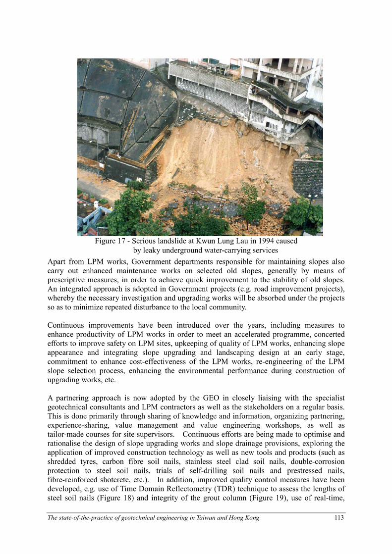
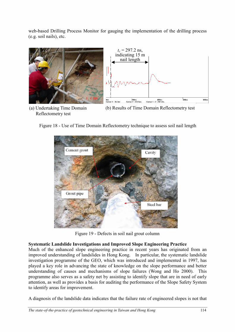
Apart from LPM works, Government departments responsible for maintaining slopes also carry out enhanced maintenance works on selected old slopes, generally by means of prescriptive measures, in order to achieve quick improvement to the stability of old slopes. An integrated approach is adopted in Government projects (e.g. road improvement projects), whereby the necessary investigation and upgrading works will be absorbed under the projects so as to minimize repeated disturbance to the local community. Continuous improvements have been introduced over the years, including measures to enhance productivity of LPM works in order to meet an accelerated programme, concerted efforts to improve safety on LPM sites, upkeeping of quality of LPM works, enhancing slope appearance and integrating slope upgrading and landscaping design at an early stage, commitment to enhance cost-effectiveness of the LPM works, re-engineering of the LPM slope selection process, enhancing the environmental performance during construction of upgrading works, etc. A partnering approach is now adopted by the GEO in closely liaising with the specialist geotechnical consultants and LPM contractors as well as the stakeholders on a regular basis. This is done primarily through sharing of knowledge and information, organizing partnering, experience-sharing, value management and value engineering workshops, as well as tailor-made courses for site supervisors. Continuous efforts are being made to optimise and rationalise the design of slope upgrading works and slope drainage provisions, exploring the application of improved construction technology as well as new tools and products (such as shredded tyres, carbon fibre soil nails, stainless steel clad soil nails, double-corrosion protection to steel soil nails, trials of self-drilling soil nails and prestressed nails, fibre-reinforced shotcrete, etc.). In addition, improved quality control measures have been developed, e.g. use of Time Domain Reflectometry (TDR) technique to assess the lengths of steel soil nails (Figure 18) and integrity of the grout column (Figure 19), use of real-time,
Figure 17 - Serious landslide at Kwun Lung Lau in 1994 caused
by leaky underground water-carrying services
The state-of-the-practice of geotechnical engineering in Taiwan and Hong Kong 114
tc = 297.2 ns, indicating 15 m nail length
(a) Undertaking Time Domain
Reflectometry test
(b) Results of Time Domain Reflectometry test
Figure 18 - Use of Time Domain Reflectometry technique to assess soil nail length
web-based Drilling Process Monitor for gauging the implementation of the drilling process (e.g. soil nails), etc.
Systematic Landslide Investigations and Improved Slope Engineering Practice
Much of the enhanced slope engineering practice in recent years has originated from an improved understanding of landslides in Hong Kong. In particular, the systematic landslide investigation programme of the GEO, which was introduced and implemented in 1997, has played a key role in advancing the state of knowledge on the slope performance and better understanding of causes and mechanisms of slope failures (Wong and Ho 2000). This programme also serves as a safety net by assisting to identify slope that are in need of early attention, as well as provides a basis for auditing the performance of the Slope Safety System to identify areas for improvement. A diagnosis of the landslide data indicates that the failure rate of engineered slopes is not that
Figure 19 - Defects in soil nail grout column
The state-of-the-practice of geotechnical engineering in Taiwan and Hong Kong 115
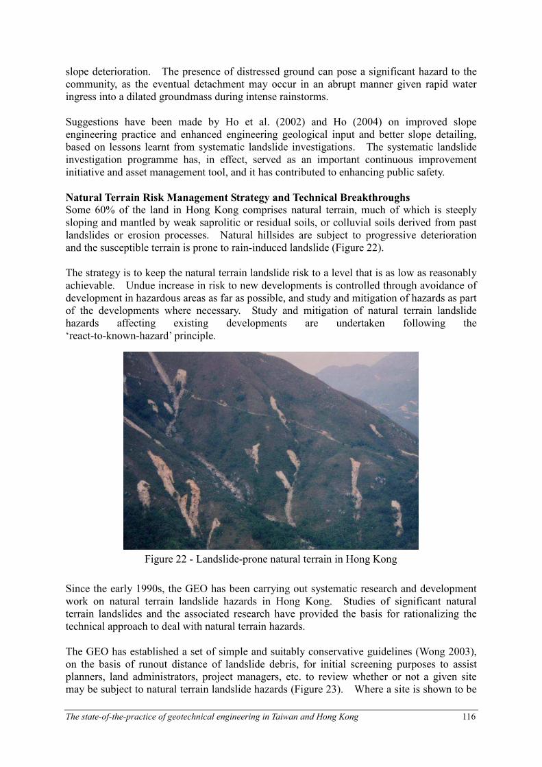
Figure 21 - Landslide controlled by local adverse geological and hydrogeological conditions
Groundwater seepage indicative of formation of local perched
water table
Relict joint in decomposed granite formed a local plane of
weakness
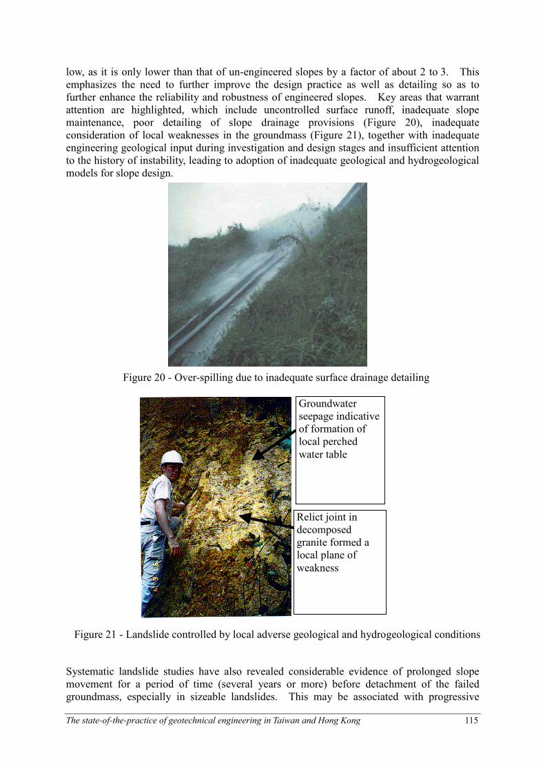
low, as it is only lower than that of un-engineered slopes by a factor of about 2 to 3. This emphasizes the need to further improve the design practice as well as detailing so as to further enhance the reliability and robustness of engineered slopes. Key areas that warrant attention are highlighted, which include uncontrolled surface runoff, inadequate slope maintenance, poor detailing of slope drainage provisions (Figure 20), inadequate consideration of local weaknesses in the groundmass (Figure 21), together with inadequate engineering geological input during investigation and design stages and insufficient attention to the history of instability, leading to adoption of inadequate geological and hydrogeological models for slope design.
Systematic landslide studies have also revealed considerable evidence of prolonged slope movement for a period of time (several years or more) before detachment of the failed groundmass, especially in sizeable landslides. This may be associated with progressive
Figure 20 - Over-spilling due to inadequate surface drainage detailing
The state-of-the-practice of geotechnical engineering in Taiwan and Hong Kong 116
slope deterioration. The presence of distressed ground can pose a significant hazard to the community, as the eventual detachment may occur in an abrupt manner given rapid water ingress into a dilated groundmass during intense rainstorms. Suggestions have been made by Ho et al. (2002) and Ho (2004) on improved slope engineering practice and enhanced engineering geological input and better slope detailing, based on lessons learnt from systematic landslide investigations. The systematic landslide investigation programme has, in effect, served as an important continuous improvement initiative and asset management tool, and it has contributed to enhancing public safety.
Natural Terrain Risk Management Strategy and Technical Breakthroughs
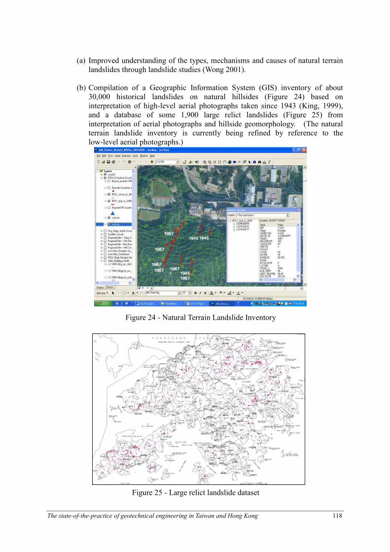
Some 60% of the land in Hong Kong comprises natural terrain, much of which is steeply sloping and mantled by weak saprolitic or residual soils, or colluvial soils derived from past landslides or erosion processes. Natural hillsides are subject to progressive deterioration and the susceptible terrain is prone to rain-induced landslide (Figure 22). The strategy is to keep the natural terrain landslide risk to a level that is as low as reasonably achievable. Undue increase in risk to new developments is controlled through avoidance of development in hazardous areas as far as possible, and study and mitigation of hazards as part of the developments where necessary. Study and mitigation of natural terrain landslide hazards affecting existing developments are undertaken following the ‘react-to-known-hazard’ principle.
Since the early 1990s, the GEO has been carrying out systematic research and development work on natural terrain landslide hazards in Hong Kong. Studies of significant natural terrain landslides and the associated research have provided the basis for rationalizing the technical approach to deal with natural terrain hazards. The GEO has established a set of simple and suitably conservative guidelines (Wong 2003), on the basis of runout distance of landslide debris, for initial screening purposes to assist planners, land administrators, project managers, etc. to review whether or not a given site may be subject to natural terrain landslide hazards (Figure 23). Where a site is shown to be
Figure 22 - Landslide-prone natural terrain in Hong Kong

The state-of-the-practice of geotechnical engineering in Taiwan and Hong Kong 117
potentially affected by landslide hazards, more refined criteria are then used to examine whether the proposed development meets the ‘in-principle objection’ criterion (i.e. to relocate the proposed development or amend development layout), or the ‘alert criteria’ (i.e. to carry out natural terrain hazard study (NTHS)and the appropriate mitigation measures as part of the development).
Technical criteria and guidance for study and mitigation of natural terrain landslide risk have been promulgated (Ng et al. 2002 and ERM 1998). The use of conventional Factor of Safety approach as mentioned in the Geotechnical Manual for Slopes (GCO 1984) is frequently fraught with difficulties. As such, two alternative approaches have been introduced, viz. the QRA approach and the Design Event approach. The details of the recommended approaches are given by Wong (2001) and Ng et al. (2002).
Apart from the development of design framework and technical guidelines, progress has also been made in the following areas:
Within 50m of Ground
Sloping at > 15o?
Yes
No
Yes
No
Natural
Terrain
Hazard Study
Required ?
Site
A
B
Yes
Yes
Natural Terrain Hazard Study
Requirement Criteria
Within 20 o Angular Elevation
of Natural Terrain ?
0 50m
50m
ground
slope
<15o
ground
slope
>15o
20o
BA
Notes:(1). A natural terrain landslide hazard study may have to be undertaken for development
sites which meet the following criteria : where there is natural terrain outside the site,
but within the same catchment, which is at an angular elevation of 20° or more from
the site and where there is natural terrain sloping at more than 15° within 50m
horizontally up slope of the site, provided that there is a credible debris flow path to
the site. 1:5,000 scale topographic maps shall be used to judge whether these criteria
are met.
(2). For sites that fall outside the above criteria, if the professional responsible for the
development considers that there is a reasonable chance that natural terrain hazards
could affect the site, then a study will be required. A natural terrain landslide hazard
study may be required for development sites which do not meet the above criteria, e.g.
development sites which are either intersected by or adjuscent to a natural drainage
course.
Figure 23 - Screening criteria for assessing the requirement of natural terrain new
development sites in Hong Kong
The state-of-the-practice of geotechnical engineering in Taiwan and Hong Kong 118
(a) Improved understanding of the types, mechanisms and causes of natural terrain landslides through landslide studies (Wong 2001).
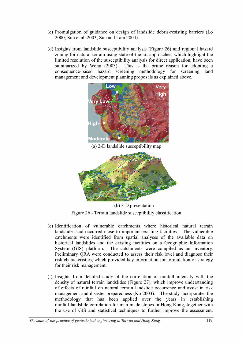
(b) Compilation of a Geographic Information System (GIS) inventory of about 30,000 historical landslides on natural hillsides (Figure 24) based on interpretation of high-level aerial photographs taken since 1943 (King, 1999), and a database of some 1,900 large relict landslides (Figure 25) from interpretation of aerial photographs and hillside geomorphology. (The natural terrain landslide inventory is currently being refined by reference to the low-level aerial photographs.)
Figure 24 - Natural Terrain Landslide Inventory
Figure 25 - Large relict landslide dataset
The state-of-the-practice of geotechnical engineering in Taiwan and Hong Kong 119
(a) 2-D landslide susceptibility map
(b) 3-D presentation
Figure 26 - Terrain landslide susceptibility classification
Very
High
High
Moderate
Low
Very Low
(c) Promulgation of guidance on design of landslide debris-resisting barriers (Lo 2000; Sun et al. 2003; Sun and Lam 2004).
(d) Insights from landslide susceptibility analysis (Figure 26) and regional hazard zoning for natural terrain using state-of-the-art approaches, which highlight the limited resolution of the susceptibility analysis for direct application, have been summarized by Wong (2003). This is the prime reason for adopting a consequence-based hazard screening methodology for screening land management and development planning proposals as explained above.
(e) Identification of vulnerable catchments where historical natural terrain landslides had occurred close to important existing facilities. The vulnerable catchments were identified from spatial analyses of the available data on historical landslides and the existing facilities on a Geographic Information System (GIS) platform. The catchments were compiled as an inventory. Preliminary QRA were conducted to assess their risk level and diagnose their risk characteristics, which provided key information for formulation of strategy for their risk management.
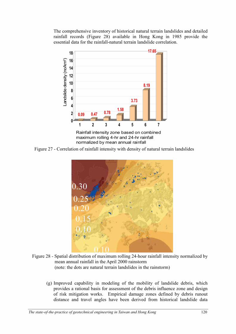
(f) Insights from detailed study of the correlation of rainfall intensity with the density of natural terrain landslides (Figure 27), which improve understanding of effects of rainfall on natural terrain landslide occurrence and assist in risk management and disaster preparedness (Ko 2003). The study incorporates the methodology that has been applied over the years in establishing rainfall-landslide correlation for man-made slopes in Hong Kong, together with the use of GIS and statistical techniques to further improve the assessment.
The state-of-the-practice of geotechnical engineering in Taiwan and Hong Kong 120
0.30
0.25 0.20
0.15
0.10
0.10
0.30
0.25 0.20
0.15
0.10
0.10
Figure 28 - Spatial distribution of maximum rolling 24-hour rainfall intensity normalized by mean annual rainfall in the April 2000 rainstorm
(note: the dots are natural terrain landslides in the rainstorm)
The comprehensive inventory of historical natural terrain landslides and detailed rainfall records (Figure 28) available in Hong Kong in 1985 provide the essential data for the rainfall-natural terrain landslide correlation.
(g) Improved capability in modeling of the mobility of landslide debris, which provides a rational basis for assessment of the debris influence zone and design of risk mitigation works. Empirical damage zones defined by debris runout distance and travel angles have been derived from historical landslide data
0.09 0.47 0.781.58
3.73
8.19
17.65
0
2
4
6
8
10
12
14
16
18
1 2 3 4 5 6 7
Landslide density (no/km2)
Rainfall intensity zone based on combined
maximum rolling 4-hr and 24-hr rainfall normalized by mean annual rainfall
Figure 27 - Correlation of rainfall intensity with density of natural terrain landslides
The state-of-the-practice of geotechnical engineering in Taiwan and Hong Kong 121
Figure 30 - 2-D debris runout modeling
0
50
100
150
200
250
300
350
400
0 100 200 300 400 500 600
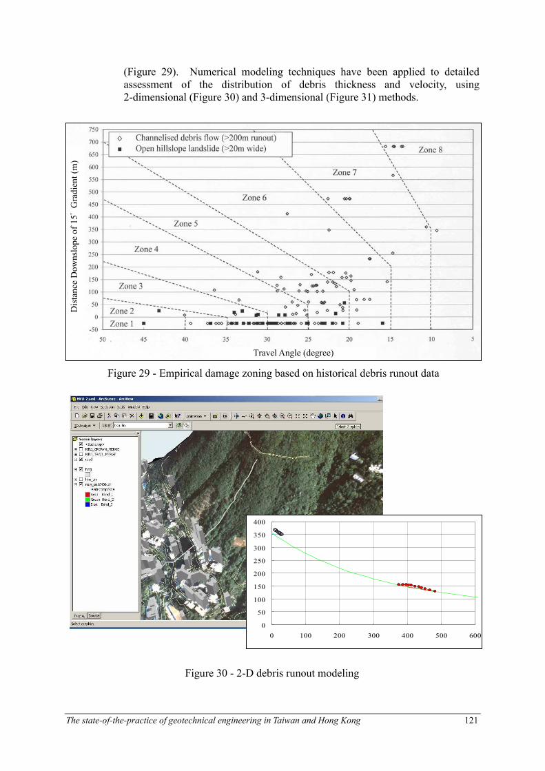
(Figure 29). Numerical modeling techniques have been applied to detailed assessment of the distribution of debris thickness and velocity, using 2-dimensional (Figure 30) and 3-dimensional (Figure 31) methods.
Figure 29 - Empirical damage zoning based on historical debris runout data
Distance Downslope of 15° Gradient (m)
Travel Angle (degree)
The state-of-the-practice of geotechnical engineering in Taiwan and Hong Kong 122
Figure 31 - 3-D debris runout modeling
A recently completed QRA has confirmed that the risk proportion of natural hillsides will become comparable to that of man-made slopes by 2010 (Wong et al. 2004b). Given the preparatory work in previous years and the recent technical and technological breakthroughs, the GEO is now in a position to reap the fruits and is in the process of gearing up to devote expanded efforts to implement a programme to systematically mitigate the risk posed by known problematic hillside catchments affecting existing developments.
Novel Application of Digital Technology
Notable advances have been made by the GEO in the application of digital technology and information technology to enhance the capability and efficiency of geotechnical work (Wong 2004). These include digital photogrammetry, Geographic Information System (GIS), Interferometric Synthetic Aperture Radar (InSAR) and Light Detection and Ranging (LIDAR). The conventional aerial photograph interpretation (API) and photogrammetric analysis using stereoscope and stereo-plotter can now be undertaken by digital means via digital photogrammetry, with improved efficiency, resolution and analytical capability. This is done through digitizing the aerial photographs with the use of a high precision and high resolution scanner, processing the digital data using an advanced digital photogrammetry algorithm, and displaying the stereo-images on a computer monitor (Figure 32). Notable applications to slope engineering work include stereo visualization and API,
Figure 32 - Digital photogrammetry system (stereo-view displayed on computer
screen)

The state-of-the-practice of geotechnical engineering in Taiwan and Hong Kong 123
(a) Ordinary aerial photograph (note: not to scale and
position-inaccurate)
(b) Ortho-rectified image (note: true to scale and
position-accurate)
Figure 33 - Conversion of ordinary aerial photograph
to ortho-rectified image
(a) Ortho-rectified image (b) Boulder extracted by image
processing technique
Figure 34 - Application of image processing to mapping of boulders
surveying and measurement without the need for detailed land surveying work, movement monitoring, compilation of digital terrain model (DTM) which has three-dimensional GIS and virtual reality applications, and conversion of conventional aerial photographs into ortho-rectified images (Figure 33). The latter are true to scale and position-accurate and can be integrated into a GIS, together with other spatial data for a range of novel GIS and remote-sensing applications (such as geotechnical field mapping, GIS data mining, feature recognition and extraction, change detection and monitoring, and virtual reality). Image analysis techniques have also been applied and refined in order to map boulders perched on natural hillsides (Figure 34, Shi et al. 2004). Apart from using GIS for managing geotechnical data and compiling GIS datasets, notable development of GIS systems and capability has been made with a view to adopting more advanced GIS functionality to deal with practical geotechnical issues.
The state-of-the-practice of geotechnical engineering in Taiwan and Hong Kong 124
(a) Uploading GIS data to the
mobile mapping system
(b) On-site navigation, data retrieval and mapping using the mobile mapping system
(c) GIS data and ortho-rectified image together with GPS location
shown on pocket computer
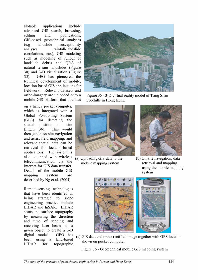
Notable applications include advanced GIS search, browsing, editing and publications, GIS-based geotechnical analyses (e.g landslide susceptibility analyses, rainfall-landslide correlations, etc.), GIS modeling such as modeling of runout of landslide debris and QRA of natural terrain landslides (Figure 30) and 3-D visualization (Figure 35). GEO has pioneered the technical development of mobile, location-based GIS applications for fieldwork. Relevant datasets and ortho-imagery are uploaded onto a mobile GIS platform that operates
on a handy pocket computer, which is integrated with a Global Positioning System (GPS) for detecting the spatial position on site (Figure 36). This would then guide on-site navigation and assist field mapping, and relevant spatial data can be retrieved for location-based applications. The system is also equipped with wireless telecommunication via the Internet for GIS data transfer. Details of the mobile GIS mapping system are described by Ng et al. (2004). Remote-sensing technologies that have been identified as being strategic to slope engineering practice include LIDAR and InSAR. LIDAR scans the surface topography by measuring the direction and time of sending and receiving laser beams to a given object to create a 3-D digital model. GEO has been using a land-based LIDAR for topographic
Figure 35 - 3-D virtual reality model of Tsing Shan
Foothills in Hong Kong
Figure 36 - Geotechnical mobile GIS mapping system
The state-of-the-practice of geotechnical engineering in Taiwan and Hong Kong 125
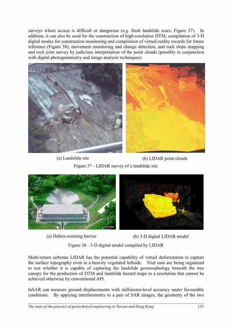
(a) Landslide site (b) LIDAR point clouds
Figure 37 - LIDAR survey of a landslide site
(a) Debris-resisting barrier (b) 3-D digital LIDAR model
Figure 38 - 3-D digital model compiled by LIDAR
surveys where access is difficult or dangerous (e.g. fresh landslide scars, Figure 37). In addition, it can also be used for the construction of high-resolution DTM, compilation of 3-D digital modes for construction monitoring and compilation of virtual-reality records for future reference (Figure 38), movement monitoring and change detection, and rock slope mapping and rock joint survey by judicious interpretation of the point clouds (possibly in conjunction with digital photogrammetry and image analysis techniques).
Multi-return airborne LIDAR has the potential capability of virtual deforestation to capture the surface topography even in a heavily vegetated hillside. Trial runs are being organized to test whether it is capable of capturing the landslide geomorphology beneath the tree canopy for the production of DTM and landslide hazard maps to a resolution that cannot be achieved otherwise by conventional API. InSAR can measure ground displacements with millimeter-level accuracy under favourable conditions. By applying interferometry to a pair of SAR images, the geometry of the two
The state-of-the-practice of geotechnical engineering in Taiwan and Hong Kong 126
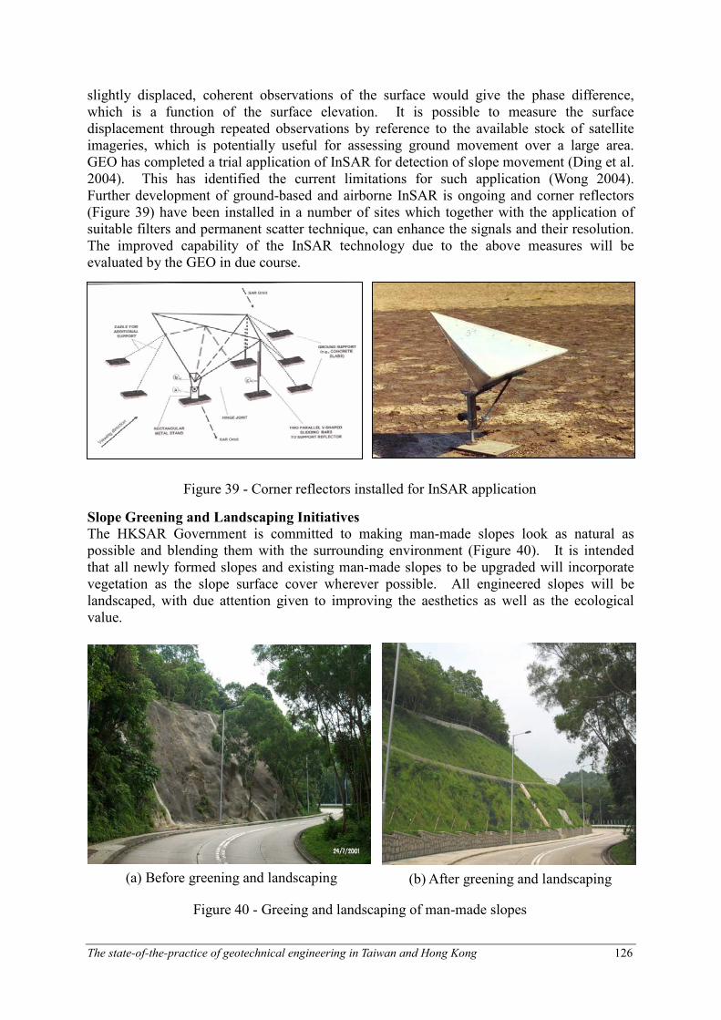
Figure 39 - Corner reflectors installed for InSAR application
(a) Before greening and landscaping (b) After greening and landscaping
Figure 40 - Greeing and landscaping of man-made slopes
slightly displaced, coherent observations of the surface would give the phase difference, which is a function of the surface elevation. It is possible to measure the surface displacement through repeated observations by reference to the available stock of satellite imageries, which is potentially useful for assessing ground movement over a large area. GEO has completed a trial application of InSAR for detection of slope movement (Ding et al. 2004). This has identified the current limitations for such application (Wong 2004). Further development of ground-based and airborne InSAR is ongoing and corner reflectors (Figure 39) have been installed in a number of sites which together with the application of suitable filters and permanent scatter technique, can enhance the signals and their resolution. The improved capability of the InSAR technology due to the above measures will be evaluated by the GEO in due course.
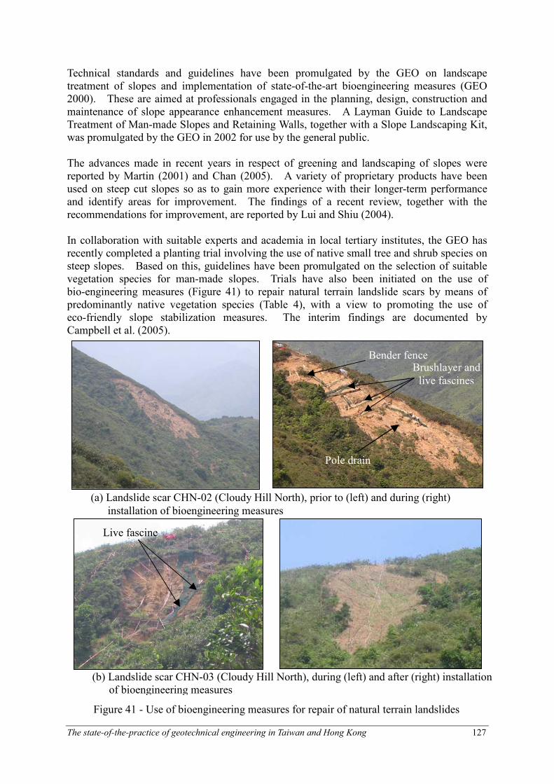
Slope Greening and Landscaping Initiatives
The HKSAR Government is committed to making man-made slopes look as natural as possible and blending them with the surrounding environment (Figure 40). It is intended that all newly formed slopes and existing man-made slopes to be upgraded will incorporate vegetation as the slope surface cover wherever possible. All engineered slopes will be landscaped, with due attention given to improving the aesthetics as well as the ecological value.
The state-of-the-practice of geotechnical engineering in Taiwan and Hong Kong 127
(b) Landslide scar CHN-03 (Cloudy Hill North), during (left) and after (right) installation of bioengineering measures
Live fascine
Brushlayer and
live fascines
Pole drain
Bender fence
(a) Landslide scar CHN-02 (Cloudy Hill North), prior to (left) and during (right)
installation of bioengineering measures
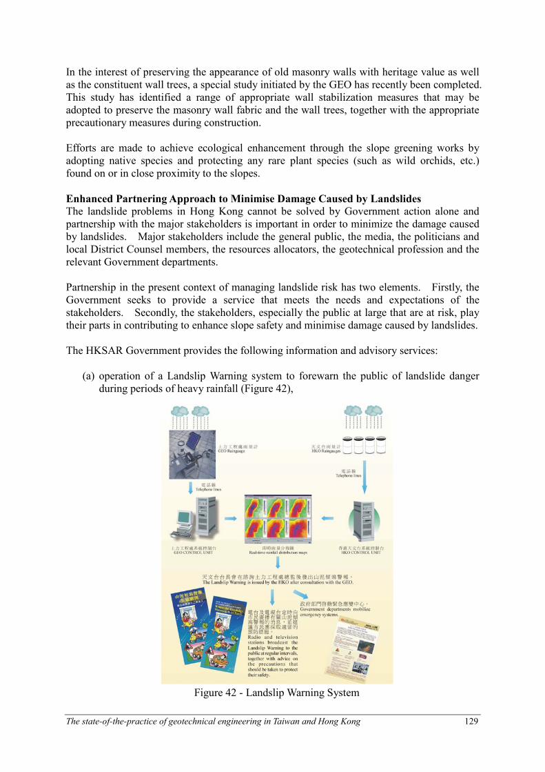
Figure 41 - Use of bioengineering measures for repair of natural terrain landslides
Technical standards and guidelines have been promulgated by the GEO on landscape treatment of slopes and implementation of state-of-the-art bioengineering measures (GEO 2000). These are aimed at professionals engaged in the planning, design, construction and maintenance of slope appearance enhancement measures. A Layman Guide to Landscape Treatment of Man-made Slopes and Retaining Walls, together with a Slope Landscaping Kit, was promulgated by the GEO in 2002 for use by the general public. The advances made in recent years in respect of greening and landscaping of slopes were reported by Martin (2001) and Chan (2005). A variety of proprietary products have been used on steep cut slopes so as to gain more experience with their longer-term performance and identify areas for improvement. The findings of a recent review, together with the recommendations for improvement, are reported by Lui and Shiu (2004). In collaboration with suitable experts and academia in local tertiary institutes, the GEO has recently completed a planting trial involving the use of native small tree and shrub species on steep slopes. Based on this, guidelines have been promulgated on the selection of suitable vegetation species for man-made slopes. Trials have also been initiated on the use of bio-engineering measures (Figure 41) to repair natural terrain landslide scars by means of predominantly native vegetation species (Table 4), with a view to promoting the use of eco-friendly slope stabilization measures. The interim findings are documented by Campbell et al. (2005).

The state-of-the-practice of geotechnical engineering in Taiwan and Hong Kong 128
Table 4 - Provisional plant species list for soil bioengineering measures
Species Form Status - Native (n) / Exotic (e) Estimated Rooting Depth
Acacia confusa Tree Common e Deep
Ardisia crenata Shrub Common n Intermediate
Baeckea frutescens Herb Very common n Intermediate
Breynia fruticosa Shrub Very common n Intermediate
Bridelia tomentosa Tree Common n Uncertain
Canthium dicoccum Shrub or tree Common n Uncertain
Celtis sinensis Tree Very common n Uncertain
Cinnamomum camphora Tree Very common n Deep
Clerodendrum viscosum Shrub Common n Intermediate
Cratoxylum cochinchinensis Tree Common n Intermediate
Croton crassifolius Shrub Common n Intermediate
Duranta erecta Shrub Common e Shallow
Ficus microcarpa Tree Very Common n Deep
Gardenia jasminoides Shrub Common n Shallow
Glochidion eriocarpum Shrub Common n Intermediate
Glochidion lanceolarium Shrub Common n Intermediate
Glochidion zeylanicum Shrub Common n Intermediate
Gordonia axillaris Tree Common n Intermediate
Ilex pubescens Shrub Very common n Intermediate
Itea chinesis Shrub/Tree Common n Intermediate
Lespedeza formosa Shrub Common n Uncertain
Liquidambar formosana Tree Very common n Deep
Litsea cubeba Tree Common n Intermediate
Litsea glutinosa Shrub Very common n Uncertain
Litsea rotundifolia Shrub Very common n Intermediate
Macaranga tanarius Tree Very common n Intermediate
Machilus breviflora Tree Common n Intermediate
Machilus checkiangensis Tree Common n Intermediate
Melastoma candidum Shrub Common n Shallow
Melastoma sanguineum Shrub Common n Intermediate
Melia azedarach Tree Introduced, common
e Deep
Melicope ptelefolia Shrub Common n Intermediate
Phyllanthus cochinchinensis Shrub Very common n Intermediate
Phyllanthus emblica Shrub Very common n Intermediate
Psychotria rubra Shrub Common n Intermediate
Raphiolepis indica Shrub Common n Intermediate
Rhamnus crenata Shrub Common n Intermediate
Rhodomyrtus tomentosa Shrub Very common n Intermediate
Rhus chinensis Shrub Very common n Intermediate
Rhus succedanea Tree Very common n Intermediate
Sapium discolor Tree Very common n Intermediate
Sarcandra glabra Shrub Very common n Shallow
Schefflera octophylla Tree Very common n Intermediate
Syzygium buxifolium Shrub/Tree Common n Intermediate
Syzygium jambos Tree Introduced, common
e Deep
Zanthoxylum avicennae Shrub Common n Intermediate
The state-of-the-practice of geotechnical engineering in Taiwan and Hong Kong 129
In the interest of preserving the appearance of old masonry walls with heritage value as well as the constituent wall trees, a special study initiated by the GEO has recently been completed. This study has identified a range of appropriate wall stabilization measures that may be adopted to preserve the masonry wall fabric and the wall trees, together with the appropriate precautionary measures during construction. Efforts are made to achieve ecological enhancement through the slope greening works by adopting native species and protecting any rare plant species (such as wild orchids, etc.) found on or in close proximity to the slopes.
Enhanced Partnering Approach to Minimise Damage Caused by Landslides The landslide problems in Hong Kong cannot be solved by Government action alone and partnership with the major stakeholders is important in order to minimize the damage caused by landslides. Major stakeholders include the general public, the media, the politicians and local District Counsel members, the resources allocators, the geotechnical profession and the relevant Government departments. Partnership in the present context of managing landslide risk has two elements. Firstly, the Government seeks to provide a service that meets the needs and expectations of the stakeholders. Secondly, the stakeholders, especially the public at large that are at risk, play their parts in contributing to enhance slope safety and minimise damage caused by landslides. The HKSAR Government provides the following information and advisory services: (a) operation of a Landslip Warning system to forewarn the public of landslide danger during periods of heavy rainfall (Figure 42),
Figure 42 - Landslip Warning System
The state-of-the-practice of geotechnical engineering in Taiwan and Hong Kong 130
(b) a 24-hour emergency service by the GEO to other Government Departments to advise on effective actions that help to minimize the impact of landslide incidents on the public,
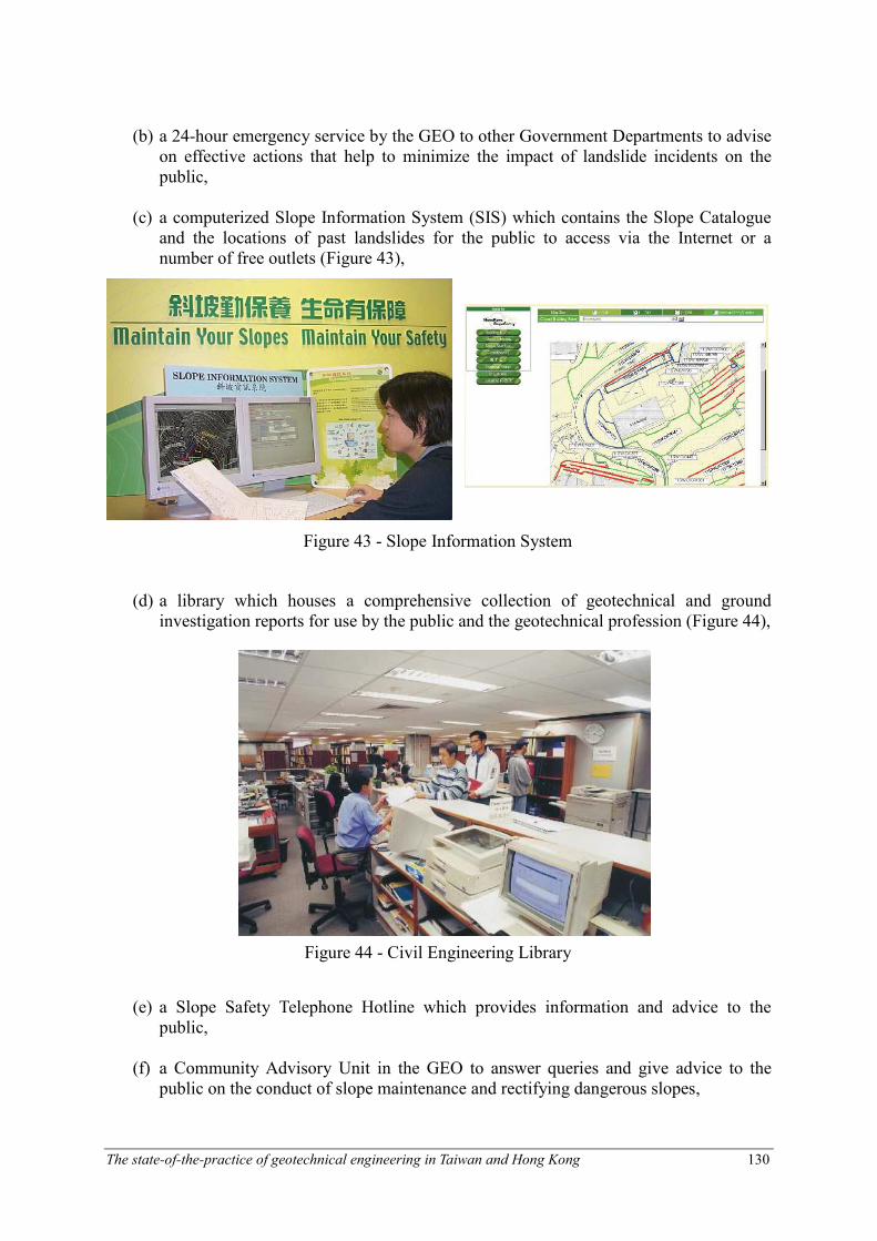
(c) a computerized Slope Information System (SIS) which contains the Slope Catalogue and the locations of past landslides for the public to access via the Internet or a number of free outlets (Figure 43),
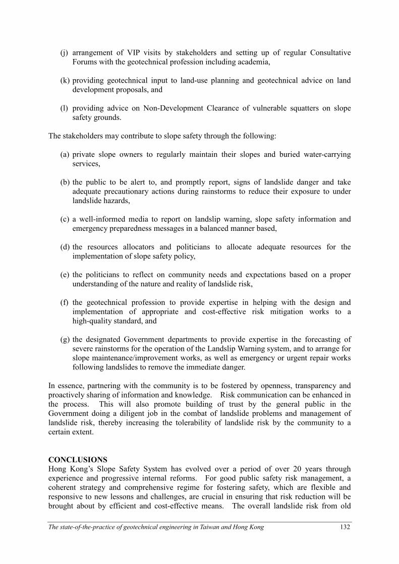
(d) a library which houses a comprehensive collection of geotechnical and ground investigation reports for use by the public and the geotechnical profession (Figure 44),
(e) a Slope Safety Telephone Hotline which provides information and advice to the public,
(f) a Community Advisory Unit in the GEO to answer queries and give advice to the public on the conduct of slope maintenance and rectifying dangerous slopes,
Figure 43 - Slope Information System
Figure 44 - Civil Engineering Library

The state-of-the-practice of geotechnical engineering in Taiwan and Hong Kong 131
(g) organization of publicity campaigns to promote regular slope maintenance and publication of a Layman Guide to Slope Maintenance,
(h) implementation of public education and awareness initiatives (e.g. importance of regular slope maintenance, and personal precautionary measures to be taken during severe rainstorms) to enhance the understanding of the nature of landslide risk and promotion of prudent actions by the general public to minimize landslide risk (Figure 45).
(i) posting of warning signage at selected vulnerable locations (Figure 46),
Figure 45 - Roving exhibitions on slope maintenance
Figure 46 - Warning Signs
The state-of-the-practice of geotechnical engineering in Taiwan and Hong Kong 132
(j) arrangement of VIP visits by stakeholders and setting up of regular Consultative Forums with the geotechnical profession including academia,
(k) providing geotechnical input to land-use planning and geotechnical advice on land development proposals, and
(l) providing advice on Non-Development Clearance of vulnerable squatters on slope safety grounds.
The stakeholders may contribute to slope safety through the following: (a) private slope owners to regularly maintain their slopes and buried water-carrying services,
(b) the public to be alert to, and promptly report, signs of landslide danger and take adequate precautionary actions during rainstorms to reduce their exposure to under landslide hazards,
(c) a well-informed media to report on landslip warning, slope safety information and emergency preparedness messages in a balanced manner based,
(d) the resources allocators and politicians to allocate adequate resources for the implementation of slope safety policy,
(e) the politicians to reflect on community needs and expectations based on a proper understanding of the nature and reality of landslide risk,
(f) the geotechnical profession to provide expertise in helping with the design and implementation of appropriate and cost-effective risk mitigation works to a high-quality standard, and
(g) the designated Government departments to provide expertise in the forecasting of severe rainstorms for the operation of the Landslip Warning system, and to arrange for slope maintenance/improvement works, as well as emergency or urgent repair works following landslides to remove the immediate danger.
In essence, partnering with the community is to be fostered by openness, transparency and proactively sharing of information and knowledge. Risk communication can be enhanced in the process. This will also promote building of trust by the general public in the Government doing a diligent job in the combat of landslide problems and management of landslide risk, thereby increasing the tolerability of landslide risk by the community to a certain extent.
CONCLUSIONS
Hong Kong’s Slope Safety System has evolved over a period of over 20 years through experience and progressive internal reforms. For good public safety risk management, a coherent strategy and comprehensive regime for fostering safety, which are flexible and responsive to new lessons and challenges, are crucial in ensuring that risk reduction will be brought about by efficient and cost-effective means. The overall landslide risk from old

The state-of-the-practice of geotechnical engineering in Taiwan and Hong Kong 133
substandard man-made slopes to the community has been reduced considerably through concerted efforts by the Government, the geotechnical profession and the private slope owners. With the anticipated increase in population and hillside development, landslide risk will tend to increase. The landslide risk can be managed to a sufficiently low level only by sustained slope safety efforts, by focusing on areas of high priority, and by partnership amongst the stakeholders. The holistic Slope Safety System adds value by saving lives and minimizing social disruption and economic losses, and facilitates safe, economic, eco-friendly and sustainable developments. Slope engineering and landslide management in Hong Kong has progressed to a stage whereby the landslide risk is examined and managed in totality. Quantified risk management is being implemented in Hong Kong to direct its urban landslide risk management initiatives. The applications have brought about considerable insight and advances in combating landslides, which make Hong Kong a role model in quantified landslide risk management. A risk-based approach is essential for a disaster prevention and mitigation mission. The pioneering efforts by the GEO in advancing the quantified risk methodology for landslides and integrating it into slope safety management and slope engineering practice have paid dividends in improving slope safety.
REFERENCES
Australian Geomechanics Society (2000). “Landslide risk management concepts and guidelines”, Australian Geomechanics Society, Sub-Committee on Landslide Risk Management, Australian Geomechanics, Vol. 35, 49-92.
Campbell, S.D.G., Shaw, R., Chao, P.A. and Dias, A. (2005). “The use of soil bioengineering measures to repair selected natural terrain landslides in Hong Kong”. Proc. of The Hong Kong Institution of Engineers Geotechnical Division Annual Seminar
on Safe and Green Slopes, 287-294. Chan, R.K.S. (2003). “10-year overview on advancement of slope engineering practice in
Hong Kong”, Proc. of International Conference on Slope Engineering, University of Hong Kong, Vol. 1, 96-121.
Chan, R.K.S. (2005). “Safe and green slopes – the holistic Hong Kong approach”, Proc. of The Hong Kong Institution of Engineers Geotechnical Division Annual Seminar on Safe
and Green Slopes, 1-26. Cheung, W.M. and Shiu, Y.K. (2000). Assessment of Global Landslide Risk Posed by
pre-1978 Man-Made Slope Features: Risk Reduction from 1977 to 2000 Achieved by the
LPM Programme, GEO Report No. 125, Geotechnical Engineering Office, Hong Kong. Ding, Y.L., Li, Z.W., Liu, G.X. Yin, J.H. and Chan, Y.Q. (2004). “Applying synthetic
aperture radar interferometry technology to detection of ground movement”, Proc. of The Hong Kong Institution of Engineers Geotechnical Division Annual Seminar on
Recent Advances in Geotechnical Engineering, 95-112. ERM (1998). Landslides and Boulder Falls From Natural Terrain: Interim Risk Guidelines,
GEO Report No. 75, Report prepared for the Geotechnical Engineering Office, Hong Kong.
Fugro Maunsell Scott Wilson Joint Venture (2001). Detailed Study of the Hillside Area below Shatin Heights Road, Landslide Study Report LSR 4/2001, Reported prepared for the Geotechnical Engineering Office, Hong Kong.
Geotechnical Control Office (1984). Geotechnical Manual for Slopes. (Second edition),

The state-of-the-practice of geotechnical engineering in Taiwan and Hong Kong 134
Geotechnical Control Office, Hong Kong. Geotechnical Control Office (1987). Guide to Site Investigation (Geoguide 2), Geotechnical
Control Office, Hong Kong. Geotechnical Engineering Office (2000). Technical Guidelines on Landscape Treatment
and Bio-engineering for Man-made Slopes and Retaining Walls in Hong Kong, GEO Publication 1/2000, Geotechnical Engineering Office, Hong Kong.
Geotechnical Engineering Office (2001). Model Specification for Soil Testing (Geospec 3), Geotechnical Engineering Office, Hong Kong.
Ho, K.K.S. (2004). “Recent advances in geotechnology for slope stabilization and landslide mitigation – perspective from Hong Kong”, Proc. of 9th International Symposium on Landslides, Rio de Janeiro, Vol. 2, 1507-1560.
Ho, K.K.S., Leroi, E. and Roberds, W. (2000). “Quantitative risk assessment – application, myths and future direction”, Proc. of International Conference on Geotechnical and Geological Engineering (GeoEng2000), Melbourne, Vol. 1, 269-312.
Ho, K.K.S., Sun, H.W. and Hui, T.H.H. (2002). Enhancing the Reliability and Robustness of Engineered Slopes, GEO Report No. 139, Geotechnical Engineering Office, Hong Kong.
King, J.P. (1999). Natural Terrain Landslide Study – the Natural Terrain Landslide Inventory, GEO Report No. 74, Geotechnical Engineering Office, Hong Kong.
Ko, F.W.Y. (2003). Correlation between Rainfall and Natural Terrain Landslide Occurrence in Hong Kong, Special Project Report SPR 7/2003, Geotechnical Engineering Office, Hong Kong.
Leroi, E. (1996). “Landslide hazard - risk maps at different scales: objectives, tools and developments”. Proc. of 7th International Symposium on Landslides, Trondheim, Norway, Vol. 1, 35-51.
Lo, D.O.K. (2000). Review of Natural Terrain Landslide Debris-resisting Barrier Design, GEO Report No. 104, Geotechnical Engineering Office, Hong Kong.
Lo, D.O.K. and Cheung, W.M. (2004). Assessment of Landslide Risk of Man-Made Slopes in Hong Kong, Advisory Report ADR 4/2004, Geotechnical Engineering Office, Hong Kong.
Lui, B.L.S. and Shiu, Y.K. (2004). Performance Assessment of Greening Techniques on Slopes. Special Project Report SPR 6/2004, Geotechnical Engineering Office, Hong Kong.
Malone, A.W. (1998). “Risk management and slope safety in Hong Kong (Keynote address)”, Proc. of The Hong Kong Institution of Engineers Geotechnical Division Annual Seminar on Slope Engineering in Hong Kong, A.A. Balkema Publisher, Vol. 1, 3-17.
Martin, R.P. (2001). “Landscaping and bio-engineering of slopes in Hong Kong (Panelist report)”, Proc. of The Hong Kong Institution of Engineers Geotechnical Division Annual Seminar on Slope Engineering in Hong Kong, A.A. Balkema Publisher, Vol. 1, 661-670.
Ng, K.C., Parry, S., King, J.P., Franks, C.A.M. and Shaw, R. (2002). Guidelines for Natural Terrain Hazard Studies, Special Project Report SPR 1/2002, Geotechnical Engineering Office, Hong Kong.
Ng, K.C., Fung, K.S. and Shum, W.L. “Applying mobile GIS technology to geotechnical fieldwork”, Proc. of The Hong Kong Institution of Engineers Geotechnical Division Annual Seminar on Recent Advances in Geotechnical Engineering, 113-121.
Royal Society (1992). “Risk: Analysis, Perception, Management”, Royal Society, London. Shi, W.I., Ng, K.C., Huang, C.Q. and Li, X.C. (2004). “Applying image processing
technology to boulder mapping”, Proc. of The Hong Kong Institution of Engineers Geotechnical Division Annual Seminar on Recent Advances in Geotechnical
The state-of-the-practice of geotechnical engineering in Taiwan and Hong Kong 135
Engineering, 177-184. Sun, H.W. and Lam, T.T.M. (2004). Use of Standardised Debris-Resisting Barriers for
Mitigation of Natural Terrain Landslide Hazards, Special Project Report No. SPR 9/2004, Geotechnical Engineering Office, Hong Kong.
Sun, H.W., Lam, T.T.M. and Tsui, H.M. (2003). Design Basis for Standardised Modules of Landslide Debris-Resisting Barriers, Technical Note TN 4/2003, Geotechnical Engineering Office, Hong Kong.
Wong, H.N. (2001). “Recent advances in slope engineering in Hong Kong”, Proc. of 14th Southeast Asian Geotechnical Conference, Hong Kong, Vol. 1, 641-659.
Wong, H.N. (2003). “Natural terrain management criteria – Hong Kong practice and experience”. Proc. of International Conference on Fast Slope Movements: Prediction and Prevention for Risk Mitigation, Naples, Italy.
Wong, H.N. (2004). “New capability and opportunity for using digital technology in Geotechnical Engineering”, Proc. of The Hong Kong Institution of Engineers Geotechnical Division Annual Seminar on Recent Advances in Geotechnical
Engineering, 77-94. Wong, H.N. (2005). “Landslide risk assessment for individual facilities”, Proc. of
International Conference on Landslide Risk Management, Vancouver, Canada, 237-296. Wong, H.N., Chan, V.M.C. & Mak, S.H. (2004a). “Regional report - development and
application of geo-informatics in Hong Kong”, Case Histories of Urban Geo-informatics, Asian Regional Technical Committee No. 10, International Society of Soil Mechanics and Geotechnical Engineering.
Wong, H.N. and Ho, K.K.S. (1996). “Travel distance of landslide debris”, Proc. of 7th International Symposium on Landslides, Trondheim, Norway, Vol. 1, 143-188.
Wong, H.N. and Ho, K.K.S. (1998). “Overview of risk of old man-made slopes and retaining walls in Hong Kong”, Proc. of The Hong Kong Institution of Engineers Geotechnical Division Annual Seminar on Slope Engineering in Hong Kong, A.A. Balkema Publisher, Vol. 1, 193-200.
Wong, H.N. and Ho, K.K.S. (2000). “Learning from slope failures in Hong Kong”, Proc. of 8th International Symposium on Landslides, Cardiff.
Wong, H.N. & Ho, K.K.S. and Chan, Y.C. (1997). “Assessment of consequence of landslides”, Proc. of International Workshop on Landside Risk Assessment, Honolulu, Hawaii, USA, 111-149.
Wong, H.N., Ko, F.W.Y. and Hui, T.H.H. (2004b). Assessment of Landslide Risk of Natural Hillsides in Hong Kong, Special Project Report SPR 5/2004, Geotechnical Engineering Office, Hong Kong.
Wong, H.N., Pang, L.S., Wong, A.C.W., Pun, W.K. and Yu, Y.F. (1999). Application of Prescriptive Measures to Slopes and Retaining Walls, GEO Report No. 56 (Second Edition), Geotechnical Engineering Office, Hong Kong.
Wong, H.N., Shum, W.W.L. and Ko, F.W.Y. (2004c). Assessment of Natural Terrain Landslide Risk on the Planned Development in Ling Pei, Lantau, Geotechnical Engineering Office, Hong Kong.
Works Branch (1996). Code of Practice on Inspection & Maintenance of Water Carrying Services Affecting Slopes, Works Branch, Hong Kong Government.
Works Bureau (1998). “Slope safety for all - Policy objectives for Works Bureau”, 1999 Policy Address, Works Bureau, Hong Kong Government.
ACKNOWLEDGEMENTS
This paper is published with the permission of the Head of the Geotechnical Engineering
The state-of-the-practice of geotechnical engineering in Taiwan and Hong Kong 136
Office and the Director of Civil Engineering and Development, Government of the Hong Kong Special Administrative Region.