SHASTA LAKE PLANNING COMMISSION
28
SHASTA LAKE PLANNING COMMISSION EMERGENCY MEETING September 16, 2019 8:00 A.M. Shasta Lake City Council Chambers 4488 Red Bluff Street ◼ Shasta Lake, CA 96019 COMMISSIONERS Darlene Brown, Chair Rod Lindsay, Vice Chair Tony Cota Cherrel Kirkland Anje Walfoort Vacant Seat Vacant Seat AGENDA 0.0 SPECIAL ETHICS WORKSHOP Ethics Training for City of Shasta Lake Planning Commission Members, trainer John S. Kenny, City Attorney. 1.0 CALL TO ORDER 1.1 Statement for the record of Planning Commissioners Present 1.2 Pledge of Allegiance 2.0 APPROVAL OF MINUTES 2.1 Approval of Minutes for the August 1, 2019 Planning Commission Meeting 3.0 REPORTS / PRESENTATION 3.1 Planning Commissioner’s Comments / Correspondence 4.0 PUBLIC COMMENT PERIOD Members of the public wishing to address the Commission on matters which are not listed on the Agenda may do so under the "Public Comment Period. ” If your comments concern an item on the regular agenda, please address the Commission when that item is open for public comment. Comments should be limited to matters within the jurisdiction of the City. The Commission cannot take action on or discuss any matter not on the agenda other than to refer the matter to staff for follow-up if necessary.
Transcript of SHASTA LAKE PLANNING COMMISSION
SHASTA LAKE PLANNING COMMISSION
EMERGENCY MEETING September 16, 2019
8:00 A.M.
Shasta Lake City Council Chambers 4488 Red Bluff Street ◼ Shasta Lake, CA 96019
COMMISSIONERS
Darlene Brown, Chair Rod Lindsay, Vice Chair Tony Cota Cherrel Kirkland Anje Walfoort Vacant Seat Vacant Seat
AGENDA
0.0 SPECIAL ETHICS WORKSHOP
Ethics Training for City of Shasta Lake Planning Commission Members, trainer John S. Kenny, City Attorney.
1.0 CALL TO ORDER
1.1 Statement for the record of Planning Commissioners Present
1.2 Pledge of Allegiance
2.0 APPROVAL OF MINUTES
2.1 Approval of Minutes for the August 1, 2019 Planning Commission Meeting
3.0 REPORTS / PRESENTATION
3.1 Planning Commissioner’s Comments / Correspondence
4.0 PUBLIC COMMENT PERIOD
Members of the public wishing to address the Commission on matters which are not listed on the Agenda may do so under the "Public Comment Period.” If your comments concern an item on the regular agenda, please address the Commission when that item is open for public comment. Comments should be limited to matters within the jurisdiction of the City. The Commission cannot take action on or discuss any matter not on the agenda other than to refer the matter to staff for follow-up if necessary.
Planning Commission Agenda Packet – September 12, 2019 Page 2 of 3
Persons wishing to address the Commission are encouraged to complete a Speaker Request form, but the form is not required in order to speak but assists staff in completing the minutes and correctly spelling people’s names. Forms are available at the back of the Council Chambers. Each speaker is allocated 3 minutes to speak. Speakers may not cede their time to others. If you have documents to present to the Commission, please provide a minimum of nine copies.
5.0 UNFINISHED BUSINESS
None
6.0 NEW BUSINESS
6.1 A Resolution of The Planning Commission of the City of Shasta Lake approving Grading Permit GP 19-03 filed by Heritage LLC., located on Lots 49, 50 and 51 of Deer Creek Manor Subdivision, Assessor’s Parcel Numbers 075-570-028, 075-570-029, and 075-570-030.
6.2 A Resolution of The Planning Commission of the City of Shasta Lake approving changes to Condition 30 of Resolution 05-01 and Mitigation Measure 6.5 and removal of Condition 33 and Mitigation Measure 6.8 For Tentative Map Pm 04-04.
7.0 REPORTS – STAFF
7.1 Staff report on status of vacant Planning Commission seats. Discussion and possible direction of recommending to City Council to change City of Shasta Lake Commission members from 7 to 5.
8.0 ADJOURNMENT
PLANNING COMMISSION MEETINGS Members of the public wishing to address the Commission on matters that are not listed on the Agenda may do so under the "Public Comment Period.” If your comments concern an item on the regular agenda, please address the Commission when that item is open for public comment. Comments should be limited to matters within the jurisdiction of the City. The Commission cannot take action on or discuss any matter not on the agenda other than to refer the matter to staff for follow-up if necessary.
1. Persons wishing to address the Commission are encouraged to complete a Speaker Request form, but the form is not required in order to speak. Forms are available at the back of the Council Chambers. Each speaker is allocated 3 minutes to speak. Speakers may not cede their time to others. If you have documents to present to the Commission, please provide a minimum of nine copies.
2. Documents associated with the agenda are on file and available for public review. Direct all inquiries to: City of Shasta Lake Planning Division, 4477 Main Street, Shasta Lake, CA 96019; (530) 275-7400. The agenda packet is also posted on the City’s website: www.cityofshastalake.org
Planning Commission Agenda Packet – September 12, 2019 Page 3 of 3
3. Commission actions on tentative maps, use permits, and variances are final unless appealed to the City Council. Appeals are subject to fees and filing deadlines. Forms and instructions for filing appeals are available from the Planning Division at the address above.
4. The Commission's action on General Plan Amendments and Zoning applications that are recommended for approval are automatically scheduled for a public hearing by the City Council. If the Commission denies the application, the application is not scheduled for City Council hearing unless an interested party files a written request for such consideration. Fees and filing information are available from the Planning Division.
5. Pursuant to Government Code §65009 (b)(2), a legal challenge in court to a land use action taken by the City may be limited to only those issues raised at the public hearing described in this notice, or in written correspondence delivered to the Planning Commission at, or prior to, the public hearing.
SHASTA LAKE PLANNING COMMISSION
REGULAR MEETING MINUTES
August 1, 2019
Shasta Lake City Council Chambers 4488 Red Bluff Street ◼ Shasta Lake, CA 96019
1.0 CALL TO ORDER (0:00)
1.1 Chair Darlene Brown called to order the August 1, 2019 regular meeting of the Shasta Lake Planning Commission and stated Planning Commissioners Kerry Jarvis, Cherrel Kirkland, Rod Lindsay, and Darrel Walter were present. Tony Cota, and Anje Walfoort were absent, excused.
1.2 Commissioner Jarvis led the Pledge of Allegiance.
2.0 APPROVAL OF MINUTES/ MEETING STATUS (1:15)
2.1 A motion was made/seconded (Kirkland/Lindsay) and passed to approve the Minutes for the June 6, 2019 Planning Commission Regular Meeting as presented.
3.0 REPORTS (1:45)
3.1 Planning Commissioner’s Comments / Correspondence
Commissioner Walter announced tonight is his last meeting as a Planning Commissioner. He has already submitted his resignation to staff.
3.2 The Quarterly Project Update was presented by Assistant City Manager Jessaca Lugo.
Commissioner Brown said the Commissioners would like to invite the City’s new Code Enforcement Officer to their September meeting.
4.0 PUBLIC COMMENT PERIOD (21:25)
NONE
5.0 UNFINISHED BUSINESS (21:41)
NONE
6.0 NEW BUSINESS (21:50)
6.1 Zoning Amendments to Chapters 17.14, 17.26, 17.28, 17.30, 17.32, 17.34, 17.36, 17.37, 17.38, 17.81, 17.84, and 17.88, which affect various districts throughout the City. Proposed Amendments to Shasta Lake Municipal Code: Planning Commission considered a Resolution recommending to the City
Page 2 of 2
Council amendments to various Chapters of the City of Shasta Lake Municipal Code to align local ordinances with state law and building code standards.
The amendments contained in Resolution PC Z 19-03 included: redefined Accessory Building Setbacks rear property line setback as ten feet; streamlined Accessory Dwelling Unit permit review process to implement requirements in state law; removed the requirement of an administrative permit for Home Occupation/Large Daycare Home; and, increased the permitted Fence Height limit from six feet to seven feet. This change is needed to align zoning and building code standards.
Jim Hamilton, Interim Development Services Director, presented the Staff Report and PowerPoint.
The Commissioners made two changes to the proposed Municipal Code language:
1. Section C.5. Utilities – The first sentence should read “Separate electric, water, and gas meters may be allowed on the property….” Strike the second sentence completely.
2. Section I Temporary Emergency Use - (originally stricken) will be corrected to “H” and will be retained until it may be moved to a more appropriate location.
Public Hearing Opened, No Public Comment, Public Hearing Closed
A motion was made/seconded (Jarvis/Lindsay) and passed to adopt Resolution PC 19-05 of the Planning Commission of the City of Shasta Lake, recommending to the City Council adoption of the proposed zoning Ordinance Amendment, Rezone 19-03, to Shasta Lake Municipal Code Title 17 (Zoning), as specified in Attachments A, B, C, and D, with changes as discussed.
6.2 (1:17:30) Appointment of three-member Planning Commission sub-committee to review potential Zoning Ordinance Amendments.
Ms. Lugo informed the Commission that Staff would like to continue this item to the next regular meeting of the Planning Commission to allow all the Commissioners the option of serving on the sub-committee.
Consent by Acclamation to continue this item to the next regular meeting of the Shasta Lake Planning Commission.
7.0 REPORTS
NONE
8.0 ADJOURNMENT – A motion was made/seconded (Kirkland/Lindsay) and passed unanimously to adjourn the meeting at 7:19 P.M.
DATE: ___________________________
Jessaca Lugo, Assistant City Manager
Page 1 of 11
CITY OF SHASTA LAKE
PLANNING COMMISSION MEETING
STAFF REPORT
September 12, 2019 Staff Assigned: Peter Bird, Associate Planner
Project: Deer Creek Manor Lots 49, 50 and 51 Grading File: GP 19-03 Assessor’s Parcel # 075-570-028, 075-570-029 and 075-570-030 Location: 2741, 2749, and 2757 Smith Applicant
Heritage LLC.
Owner Mark Gunlogson Jr. Representative Mark Gunlogson Jr. Zoning R1-BSM Significant / Applicable Legal Authority
California Environmental Quality Act (Public Resources Code) Shasta Lake Municipal Code (MC) Title 15 (Building and Construction)
Environmental Determination: Mitigated Negative Declaration (MND)– Previously Adopted
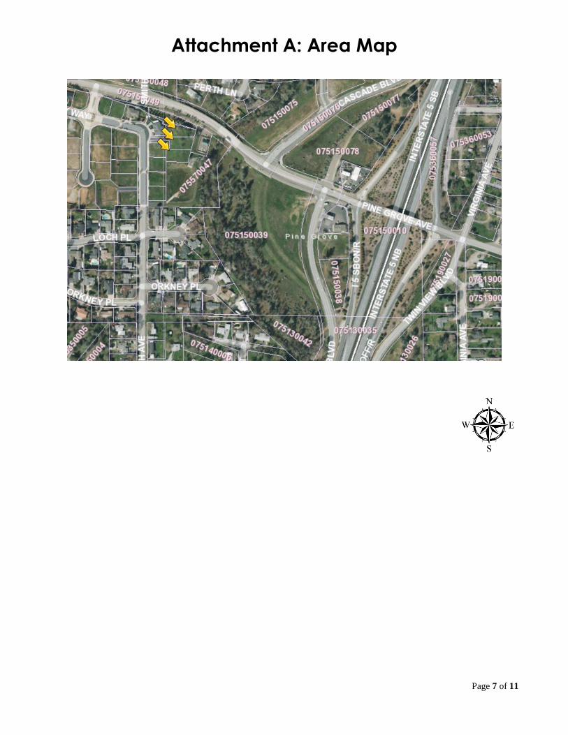
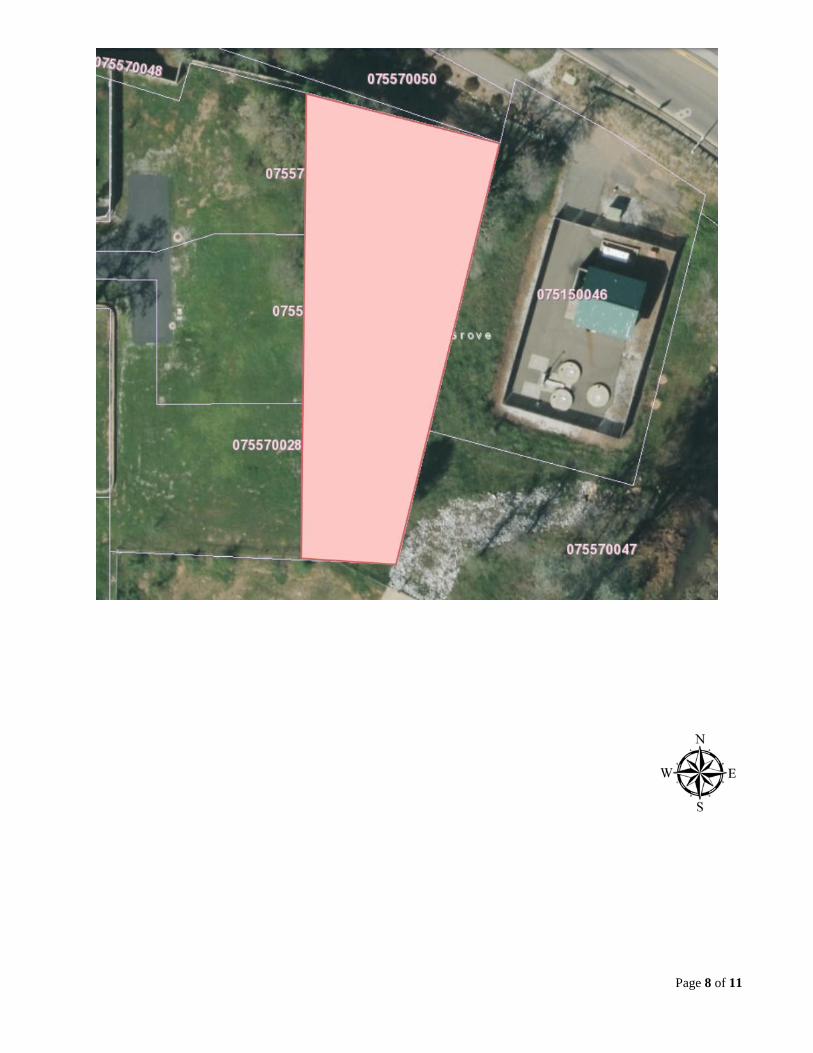
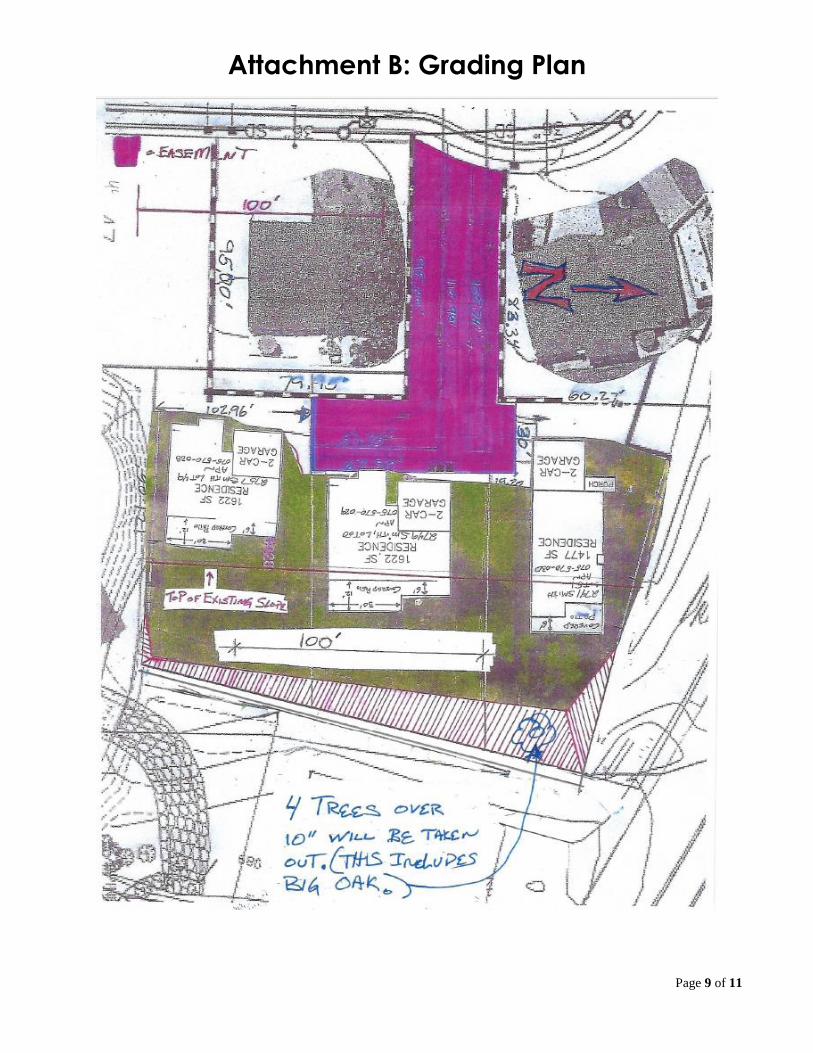
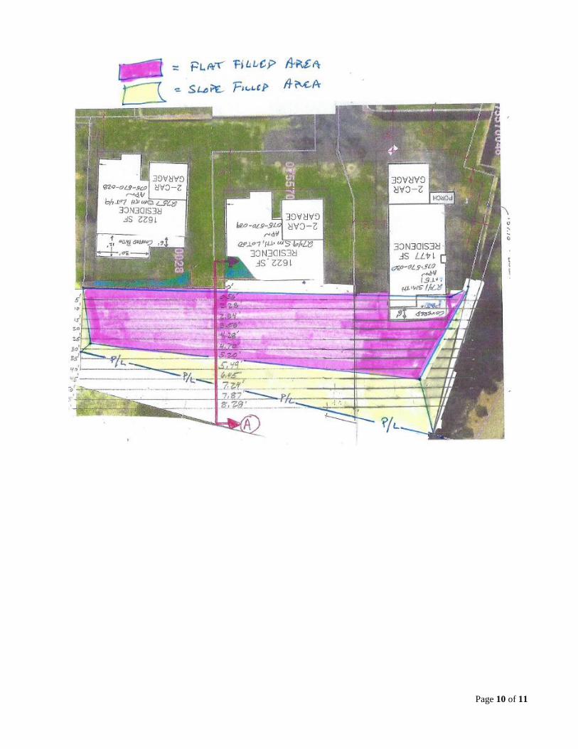
PROJECT DESCRIPTION: The applicant is requesting an amendment to Grading Permit 19-03 (GP) that will include 1,150 1,415 cubic yards of fill on lots 49 and 50, 2749 and 2757 Smith Avenue, of the Deer Creek Manor (DCM) subdivision. The grading will take place on approximately .15 .2 acres of the half acre site. Approval of this permit may only be granted by the City of Shasta Lake Planning Commission due to required exceptions to municipal code (MC) Section 15.08.210. PROJECT SETTING: The subject property is located east of Smith Avenue, on lots 49, 50, and 51 APNs 075-570-028, 075-570-029, and 075-570-030 of the DCM subdivision. Residential uses border the west side of the project site. A biologically sensitive area is directly north of the site, while public property adjoins the south and east property lines. Churn Creek is located 130 feet east of the project. Due to the previous development of this property, existing vegetation is limited to various types of brush and several small trees. The lots were created as part of the DCM subdivision in 2006 and prior to the City’s adoption of the current grading ordinance. The property ranges from level building pads to 8% slopes. The proposed grading will fill the area of 8% slope to expand rear yards of the subject parcels. The resultant fill will terminate with a 2:1 slope approximately seven 12 feet in height.
ITEM 6.1
Page 2 of 11
Site History: Deer Creek Manor had its origins in the late 1990’s with a submittal by Kent Associates of a five lot tentative map for the entire site, including the undeveloped land directly west of the currently developed area. This final map recorded on June 8th, 2000 (Recorded Map 22-57). A few years later, Knighten Enterprises and Albert Naticchioni submitted an application to subdivide parcels one and three of the previous map into what we see today. This map included 88 parcels and recorded March 28, 2006 (Recorded Map 23-97). The proposed grading permit encompasses lots 49, 50 and 51 of DCM. Mark Gunlogson, Jr. (the Applicant) of Heritage LLC proposes to add the fill to the eastern portion of the lots to increase the useable portion of the parcel. The fill is not intended to support structures. A preservation area for the Valley Elderberry Longhorn Beetle had been located on lots 50 and 51. This area contained several elderberry bushes, and in 2006 (during the approval of the subdivision), was considered critical habitat for the beetle. In 2017, the US Fish and Wildlife Service (USFWS) reviewed the status of the beetle, and in that process reduced its range to areas located below 500 feet in elevation. On August 9th, 2019, the USFWS confirmed the City of Shasta Lake no longer falls within the expected range of the beetle. The addition of lot 51 to this permit is directly connected to that determination. In compliance with the conditions of the final map, the City allowed the applicant to remove the preservation area with the intention of completing additional grading in preparation for a new home. Land Use Information:
SURROUNDING PROPERTIES GENERAL PLAN AND ZONING
EXISTING USE
Subject Property GP=SR Zone = R1-BSM New single family construction
North GP=SR Zone = R1-BSM Vacant single family lot
South GP=SR Zone = R1-BSM DCM detention basin
East GP=SR Zone = PF Sewer pump station
West GP=SR Zone = R1-BSM New single family construction
Analysis: When analyzing a grading permit the City must determine the applicability of Title 15, Chapter 08 (Grading, Erosion Control, and Hillside Development) of the MC and whether or not the proposed grading will be located within a “hillside area” as defined by MC Section 15.08.030, which states; "Hillside area" means a parcel or portion of a parcel that: 1. Contains an average slope over twenty (20) percent and a height differential of twenty (20) feet or more within the area having an average slope of twenty (20) percent or more; and 2. Where development of the project would be prominently visible from a substantial land area, including public streets and highways, public parks and open space areas, and neighboring properties; or 3. Where, due to the soil classification, the potential for erosion is high.”
Page 3 of 11
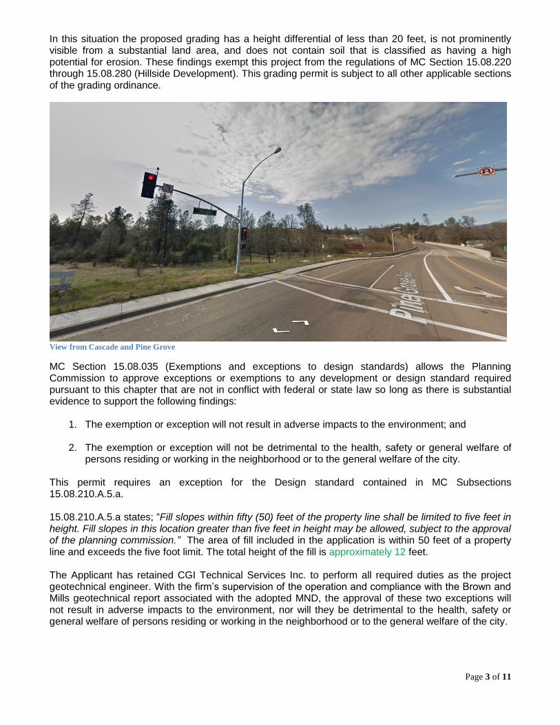
In this situation the proposed grading has a height differential of less than 20 feet, is not prominently visible from a substantial land area, and does not contain soil that is classified as having a high potential for erosion. These findings exempt this project from the regulations of MC Section 15.08.220 through 15.08.280 (Hillside Development). This grading permit is subject to all other applicable sections of the grading ordinance.
View from Cascade and Pine Grove
MC Section 15.08.035 (Exemptions and exceptions to design standards) allows the Planning Commission to approve exceptions or exemptions to any development or design standard required pursuant to this chapter that are not in conflict with federal or state law so long as there is substantial evidence to support the following findings:
1. The exemption or exception will not result in adverse impacts to the environment; and
2. The exemption or exception will not be detrimental to the health, safety or general welfare of persons residing or working in the neighborhood or to the general welfare of the city.
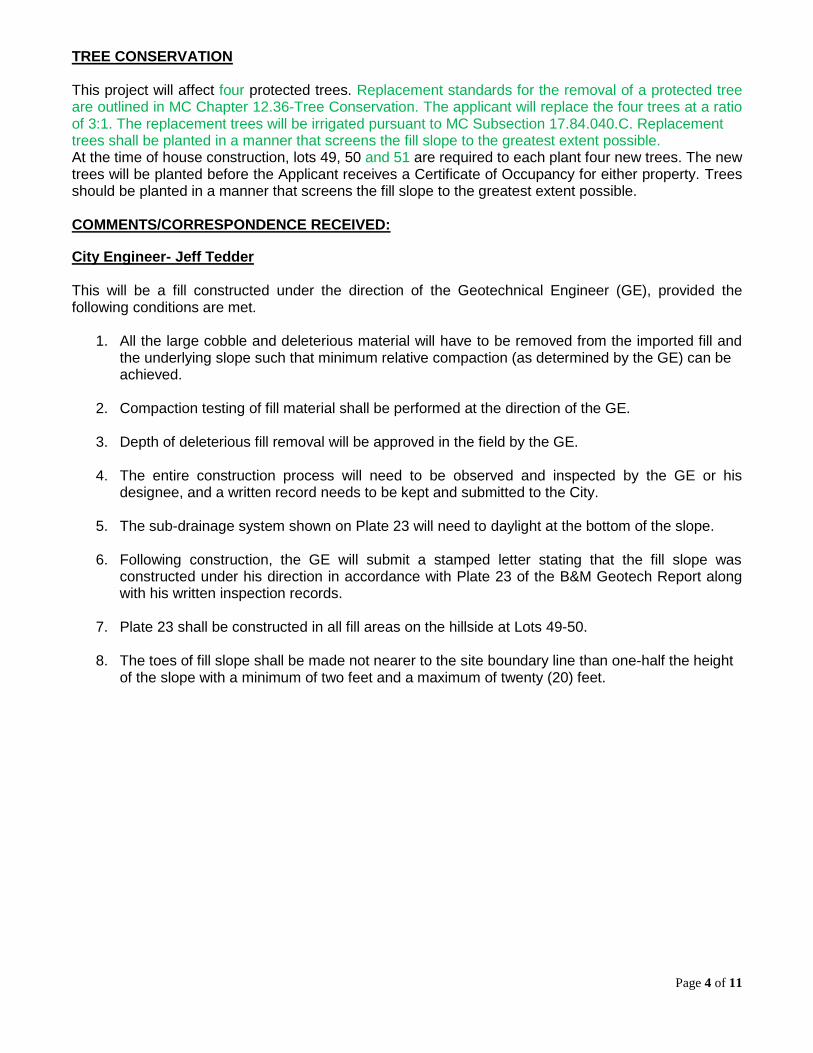
This permit requires an exception for the Design standard contained in MC Subsections 15.08.210.A.5.a. 15.08.210.A.5.a states; “Fill slopes within fifty (50) feet of the property line shall be limited to five feet in height. Fill slopes in this location greater than five feet in height may be allowed, subject to the approval of the planning commission.” The area of fill included in the application is within 50 feet of a property line and exceeds the five foot limit. The total height of the fill is approximately 12 feet. The Applicant has retained CGI Technical Services Inc. to perform all required duties as the project geotechnical engineer. With the firm’s supervision of the operation and compliance with the Brown and Mills geotechnical report associated with the adopted MND, the approval of these two exceptions will not result in adverse impacts to the environment, nor will they be detrimental to the health, safety or general welfare of persons residing or working in the neighborhood or to the general welfare of the city.
Page 4 of 11
TREE CONSERVATION This project will affect four protected trees. Replacement standards for the removal of a protected tree are outlined in MC Chapter 12.36-Tree Conservation. The applicant will replace the four trees at a ratio of 3:1. The replacement trees will be irrigated pursuant to MC Subsection 17.84.040.C. Replacement trees shall be planted in a manner that screens the fill slope to the greatest extent possible. At the time of house construction, lots 49, 50 and 51 are required to each plant four new trees. The new trees will be planted before the Applicant receives a Certificate of Occupancy for either property. Trees should be planted in a manner that screens the fill slope to the greatest extent possible. COMMENTS/CORRESPONDENCE RECEIVED:
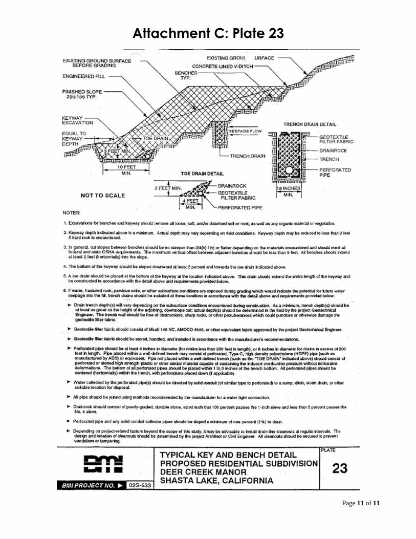
City Engineer- Jeff Tedder This will be a fill constructed under the direction of the Geotechnical Engineer (GE), provided the following conditions are met.
1. All the large cobble and deleterious material will have to be removed from the imported fill and
the underlying slope such that minimum relative compaction (as determined by the GE) can be achieved.
2. Compaction testing of fill material shall be performed at the direction of the GE.
3. Depth of deleterious fill removal will be approved in the field by the GE.
4. The entire construction process will need to be observed and inspected by the GE or his designee, and a written record needs to be kept and submitted to the City.
5. The sub-drainage system shown on Plate 23 will need to daylight at the bottom of the slope.
6. Following construction, the GE will submit a stamped letter stating that the fill slope was constructed under his direction in accordance with Plate 23 of the B&M Geotech Report along with his written inspection records.
7. Plate 23 shall be constructed in all fill areas on the hillside at Lots 49-50.
8. The toes of fill slope shall be made not nearer to the site boundary line than one-half the height of the slope with a minimum of two feet and a maximum of twenty (20) feet.
Page 5 of 11
Department of Fish and Wildlife- Amy Henderson
9. The Department has reviewed the information you provided for the grading of Lots 49 and 50. There are no new significant impacts related to this grading. The impacts were previously analyzed and mitigation measures were developed to ensure that all impacts were mitigated to less than significant. The Department has no further comments as they pertain to biological resources. The Valley Elderberry Longhorn Beetle is not regulated by CDFW.
US Fish and Wildlife Service- Lily Douglas
10. The Service re-evaluated the range of the valley elderberry longhorn beetle in the past couple years and issued a revised framework for assessing effects in 2017. The city of Shasta Lake no longer falls within the expected range of the beetle.
CONSISTENCY FINDINGS/EVIDENCE 1. State Planning and Zoning Act
Approval of the Grading Permit is consistent with both the General Plan and Title 15 of the Shasta Lake Municipal Code: Planning Commission action to approve the Grading Permit must reflect adoption of the required findings as set forth in this report. Satisfaction of all required findings to allow issuance of the grading approval will by necessity reflect a determination that the action is consistent with the General Plan and Title 15.
2. California Environmental Quality Act (Public Resources Code)
Page 6 of 11
CEQA Substantial Conformance Review: The Planning Commission of the City of Shasta Lake finds the proposed grading is in substantial conformance with all applicable sections of the MND adopted August 1st, 2003 for the project site. The Planning Commission also finds, with said action that the adopted MND associated with Recorded Map 23-97, known as Deer Creek Manor, addressed environmental impacts associated with site development. Further, the Commission finds that there is no substantial evidence that the proposed grading will involve substantial changes to the original MND that would require major revisions of the mitigated negative declaration due to the involvement of new or significantly more severe environmental effects. The approved subdivision has been under construction since 2006 and is in the final stages of development of individual lots. The mitigation measures adopted for the DCM project are applicable to the proposed grading.
3. The approval of the subject grading permit will not, under the circumstances of the particular case, be detrimental to the health, safety, peace, morals, comfort and general welfare of persons residing or working in the area or be detrimental or injurious to property or improvements in the area or to the general welfare of the City.
As conditioned in Resolution 19-03, the proposed grading will conform to all applicable requirements of Municipal Code Chapter 15.08. The project must also comply with all mitigation measures and geotechnical report from the adopted mitigated negative declaration, except as may be modified by this approval.
PLANNING COMMISSION OPTIONS The Planning Commission has several options with respect to the applicant’s request at this time: 1. Approve the Grading Permit: The Planning Commission has the option to adopt the proposed
Resolution of Approval as presented or with modified or added conditions. Modified conditions may result in an environmental impact. To determine that impact, the approval should be continued to a date certain.
2. Continue Action in Order to Obtain Additional Information: The Planning Commission may desire additional information or require further investigation by Staff. The Commission has the option to continue the matter to a certain future date in order to accomplish these efforts.
3. Deny the Grading Permit: The Planning Commission may determine, after hearing testimony
during the public hearing, to deny the Grading Permit. STAFF RECOMMENDATION Staff recommends the Planning Commission approve Grading Permit 19-XX by approving proposed Resolution of Approval 19-XX. As conditioned, the proposed project is consistent with the General Plan and Title 15 of the Municipal Code. The proposed use would not be detrimental to the health, safety or general welfare of persons living or working in the surrounding area as documented in the findings above. ATTACHMENTS Attachment A: Area Map Attachment B: Grading Plan Attachment C: Plate 23
Page 7 of 11
Attachment A: Area Map
Page 8 of 11
Page 9 of 11
Attachment B: Grading Plan
Page 10 of 11
Page 11 of 11
Attachment C: Plate 23
RESOLUTION PC 19-XX
A RESOLUTION OF THE PLANNING COMMISSION OF THE CITY OF SHASTA LAKE APPROVING GRADING PERMIT GP 19-03 FILED BY HERITAGE LLC., LOCATED ON LOTS 49, 50 AND 51 OF DEER CREEK MANOR SUBDIVISION, ASSESSOR’S PARCEL NUMBERS 075-570-028, 075-570-
029, and 075-570-030.
WHEREAS, the Planning Commission of the City of Shasta Lake considered Grading Application GP 19-03 filed by Heritage LLC for that property identified as Assessor’s Parcel Numbers 075-570-028, 075-570-029, and 075-570-030 in accordance with Title 15 of the Municipal Code; and WHEREAS, City Staff used the following information as dated: Grading Permit Application (1-17-2019), Mitigated Negative Declaration (6-16-2003), Brown and Mills Geotechnical Report (1-7-2003), CGI geotechnical review (3-22-2019), Grading Plan (3-14-2019), and Environmental Information Form (2-15-2019), Storm Water Pollution Prevention Plan (3-7-2019), Updated Grading Plan (8-15-2019); and, WHEREAS, Municipal Code Section 15.08.035 allows the Planning Commission to approve exceptions or exemptions to any development or design standard required pursuant to this chapter (15.08, Grading, Erosion Control, and Hillside Development); and, WHEREAS, said exceptions include an increased limit to the total height of the fill slope as described in Municipal Code Subsection 15.08.210.A.5.a; and, WHEREAS, said Grading Permit application was referred to outside agencies and the City’s applicable departments for review; and, WHEREAS, comments from agencies and departments who responded have been incorporated into this resolution; and, WHEREAS, the Planning Commission reviewed the staff recommendation that the proposed grading complies with the adopted mitigated negative declaration for the Deer Creek Manor Subdivision; and, WHEREAS, on September 12, 2019, the Planning Commission held a duly noticed public hearing to obtain testimony regarding the proposed grading. NOW, THEREFORE, BE IT RESOLVED, that the Planning Commission of the City of Shasta Lake: A. Makes the following findings:
1. The Grading Permit, as conditioned, is consistent with the goals, policies and objectives,
and land use map, of the City of Shasta Lake General Plan and Municipal Code Chapter 15.08, Grading, Erosion Control, and Hillside Development. Planning Commission action to approve the Grading Permit must reflect adoption of the required findings as set forth in this report. Satisfaction of all required findings to allow issuance of the grading approval will by necessity reflect a determination that the action is consistent with the General Plan and Title 15.
2. The proposed exception to Subsection 15.08.210.A.5.a of the Municipal Code will not
result in adverse impacts to the environment.
3. The proposed exception to Subsection 15.08.210.A.5.a of the Municipal Code will not be detrimental to the health, safety or general welfare of persons residing or working in the neighborhood or to the general welfare of the city. As conditioned, the proposed grading

Page 2 of 4
will conform to all applicable requirements of Municipal Code Chapter 15.08. The project must also comply with all mitigation measures and geotechnical report from the adopted mitigated negative declaration, except as may be modified by this approval. The Evaluation of Environmental Impact (Initial Study) was prepared pursuant to the California Environmental Quality Act for the Deer Creek Manor Subdivision.
4. Based on substantial evidence in light of the whole record, there is no evidence of a new significant impact associated the proposed grading that has not been addressed in the adopted Mitigated Negative Declaration (MND). The Planning Commission of the City of Shasta Lake finds the proposed grading is in substantial conformance with all applicable sections of the MND adopted August 1st, 2003 for the project site. The Planning Commission also finds with said action that the adopted MND associated with Recorded Map 23-97, known as Deer Creek Manor, addressed environmental impacts associated with site. Further the Commission finds that there is no substantial evidence that the proposed grading will involve substantial changes to the original MND that would require major revisions of the mitigated negative declaration due to the involvement of new or significantly more severe environmental effects. The approved subdivision has been under construction since 2006 and is in the final stages of development of individual lots. The mitigation measures adopted for the DCM project are applicable to the proposed grading.
B. Approves Grading Permit Number GP 19-03, subject to the following conditions:
1. The requirements of all concerned governmental agencies having jurisdiction by law,
including, but not limited to, the issuance of appropriate permits, shall be met.
2. The proposed grading shall comply with all requirements of City of Shasta Lake Municipal Code Title 15.08, (Grading, Erosion Control, and Hillside Development).
PERFORMANCE STANDARDS 3. Property corners and lines shall be identified on the ground by staking and flagging
when grading is proposed within ten feet of abutting properties or rights-of-way.
4. Work site perimeter containment/erosion control sufficient to prevent the transport of earth materials or silt contaminated storm water runoff off-site or onto rights-of-way, into water bodies, drainage courses, or environmentally sensitive areas is required.
5. The following standard mitigation measures shall be applied during grading activities to
control dust and PM10 emissions: a. Suspend all grading operations when winds (as instantaneous gusts) exceed 20
miles per hour. b. Water active construction sites at least twice daily, as directed by the Public Works
Department. c. Apply non-toxic soil stabilizers according to the manufacturer’s specification to all
graded areas which will be inactive for ten days or more. d. Provide temporary traffic control (flag person), as appropriate, during all phases of
construction to improve traffic flow.
Page 3 of 4
e. All public roadways used by the project contractor shall be maintained free from dust, dirt and debris caused by construction activities. Streets shall be swept at the end of the day if visible soil materials are carried onto adjacent public paved roads. Wheel washers shall be used where vehicles enter and exit unpaved roads onto paved roads, or trucks and any equipment shall be washed off prior to leaving the site with each trip.
f. An adequate vehicle access point, such as a crushed rock entrance sufficient to
prevent the transport of dirt, mud, and debris offsite, shall be required. g. All trucks hauling dirt, sand, soil or other loose materials should be covered or should
maintain at least two feet of freeboard (minimum vertical distance between the top of the load and the top of the trailer), in accordance with the requirements of California Vehicle Code Section 23114. This provision is enforced by local law enforcement agencies.
h. Construction activities that could affect traffic flow shall be scheduled for off-peak
hours. Heavy truck trips involved in the hauling of soil to the site shall be limited to the hours of 9:00 A.M. to 4:00 P.M., Monday through Friday. Hauling activity may occur on Saturday from 8:00 A.M. to 6:00 P.M. No work is allowed on Sundays.
i. Exposed stockpiles of soil and other fill material shall either be covered, watered or
have soil binders added to inhibit dust and wind erosion.
BIOLOGICAL RESOURCES
6. Replacement standards for the removal of a protected tree shall be those outlined in MC
Chapter 12.36-Tree Conservation.
7. Replacement trees shall be planted in a manner that screens the fill slope to the greatest extent possible.
8. All replacement trees shall be irrigated pursuant to MC Subsection 17.84.040.C.
MITIGATION MEASURES 9. All applicable sections of the Mitigated Negative Declaration adopted August 1st, 2003
for the project site are hereby incorporated into this resolution.
10. MM8.6- During construction the developer shall comply with the following time periods established for construction activities. Construction activities shall not occur outside of the following established limits unless approved by the City under special circumstances:
a. Monday through Friday: 7:00 A.M. – 7:00 P.M.
b. Saturday: 8:00 A.M. – 5:00 P.M.
c. Sunday: No construction activities allowed.
Special circumstances include the need to complete construction along public roadways or within public utilities to ensure continued services or safe conditions. Such exceptions shall be approved prior to commencement of the work.
Page 4 of 4
GEOTECHNICAL 11. Recommendations included in the Geotechnical Study prepared by Brown and Mills Inc.,
dated January 7, 2003, and in the geotechnical letter prepared by CGI Technical Services, Inc., dated March 22, 2019 are hereby incorporated into this resolution.
Engineering Conditions Engineer- Jeff Tedder/Will Bond 12. All the large cobble and deleterious material shall be removed from the imported fill and
the underlying slope such that minimum relative compaction (as determined by the GE) can be achieved.
13. Compaction testing of fill material shall be performed at the direction of the GE.
14. Depth of deleterious fill removal will be approved in the field by the GE.
15. The entire construction process will need to be observed and inspected by the GE or his designee, and a written record shall be kept and submitted to the City.
16. The sub-drainage system shown on Plate 23 shall daylight at the bottom of the slope.
17. Following construction, the GE will submit a stamped letter stating that the fill slope was constructed under his direction in accordance with Plate 23 of the B&M Geotech Report along with his written inspection records.
18. Plate 23 shall be constructed in all fill areas on the hillside at Lots 1-2.
19. The toes of fill slope shall be made not nearer to the site boundary line than one-half the height of the slope with a minimum of two feet and a maximum of twenty (20) feet.
DULY PASSED AND ADOPTED this 12th day of September, 2019 by the following vote: AYES: NOES: ABSENT:
_________________________________________ Darlene Brown, Chair Planning Commission, City of Shasta Lake, State of California
ATTEST: __________________________________ Jessaca Lugo, Assistant City Manager and Planning Commission Secretary
Page 1 of 6
CITY OF SHASTA LAKE
PLANNING COMMISSION MEETING
STAFF REPORT
September 5, 2019 Staff Assigned: Peter Bird, Associate Planner
Project: Tentative Parcel Map 04-04; Modification to Conditions and Mitigation File: PM 04-04 Assessor’s Parcel # 007-150-050, 007-150-052, 007-150-053 Location: 2517, 2567, and 2593 Smith Avenue Applicant
Heritage LLC.
Owner Mark Gunlogson Jr. Representative Mark Gunlogson Jr. Zoning R1-BSM Significant / Applicable Legal Authority
California Environmental Quality Act ( Public Resources Code) Shasta Lake Municipal Code (MC) Title 15 (Building and Construction)
Environmental Determination: Mitigated Negative Declaration (MND)– Previously Adopted
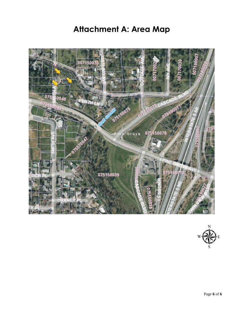
PROJECT DESCRIPTION: The applicant is requesting modification to mitigation measure 6.5 and condition 30 of planning commission resolution 05-01 and the removal of condition 33 and mitigation measure 6.8 of the approved resolution for Parcel Map 04-04 and associated mitigated negative declaration. PROJECT SETTING: The subject property is located north of Pine Grove Avenue, south of Deer Creek Avenue, and west of Ostling Avenue, APNs 007-150-050, 007-150-052, and 007-150-053. Residential uses surround the project site. A tributary of Salt Creek flows along the north and east property lines creating a flood zone for much of parcels 050 and 053. The lots were created as part of Parcel Map 04-04 filed by Terry Smith and Larry Thompson in 2005. Land Use Information:
SURROUNDING PROPERTIES GENERAL PLAN AND ZONING
EXISTING USE
Subject Property GP=SR Zone = R1-BSM New single family construction
ITEM 6.2
Page 2 of 6
North GP=SR Zone = R1-B12 Single family
South GP=SR Zone = R1-BSM DCM detention basin
East GP=SR Zone = R1-B12 Single family
West GP=SR Zone = R1-B12 Single Family Site History: In 2005, Smith and Thompson requested approval of a tentative map to subdivide an approximately 1.68-acre parcel into four separate parcels. With the approval of the parcel map and mitigated negative declaration, improvements for this four lot subdivision were constructed. Pursuant to the Subdivision Map Act, improvements related to building site preparation were left for future home builders to complete. This deferred improvements such as pad grading, tree removal, and compliance with certain conditions and mitigation measures to the time a building permit was applied for. Analysis: The project applicant, Mark Gunlogson, Jr, has requested a change to the following condition and mitigation measure of the subject parcel map.
Condition 30 (PC 05-01) Prior to the issuance of grading permits or any land clearing work necessary to install building pads or other improvements, the developer shall provide to the Development Services Director a final count of protected trees to be removed and a tree replacement plan. Three fifteen-gallon tree shall be planted for each protected tree removed than exceeds ten (10) inches diameter at breast height, pursuant to Section 12.36.170 of the Shasta Lake Municipal Code. Mitigation Measure 6.5: Prior to the issuance of grading permits or any land clearing work necessary to install building pads or other improvements, the developer shall provide to the Development Services Director a final count of protected trees to be removed and a tree replacement plan. Three fifteen-gallon tree shall be planted for each protected tree removed than exceeds ten (10) inches diameter at breast height, pursuant to Section 12.36.170 of the Shasta Lake Municipal Code.
The project applicant has also requested removal of the following condition and mitigation measure of the subject parcel map.
Condition 33 (PC 05-01) Pursuant to Chapter 12.36 of the City’s Tree Conservation Ordinance, a minimum of three 15-gallon trees shall be planted per parcel prior to issuance of a certificate of occupancy for the dwelling unit (a total of 12 15-gallon trees for 4 parcels). Mitigation Measure 6.8: Pursuant to Chapter 12.36 of the City’s Tree Conservation Ordinance, a minimum of three 15-gallon trees shall be planted per parcel prior to issuance of a certificate of occupancy for the dwelling unit (a total of 12 15-gallon trees for 4 parcels).
Page 3 of 6
The Applicant has applied for a building permit for three single family homes to be built on the subject parcels. In compliance with the above requirements, he submitted a tree removal plan that would result in the loss of 11 protected trees. Per the standards set forth in 12.36.170(070), and in compliance with the approved condition and mitigation measure, Mr. Gunlogson is required to plant 42 trees (see figure 1). The blue circles in the figures below represent the approximate required space (500 square feet) needed to support a mature tree while the red rectangles represent the proposed new homes. The first figure represents what the parcels would look like if the current standard is upheld. It is apparent with this layout that very little space will be available for any other use. This tree planting standard also conflicts with fire safe forest management practices. The fire district is opposed to creating a continuous canopy that could support the spread of fire. Mr. Gunlogson has requested a reduction in tree planting standards from 3:1 plus an additional 3 trees per house, to
1:1 (see figure 2). If approved, this request requires the modification of PC resolution 05-01, conditions 30 and 33, and mitigation measures 6.5 and 6.8. These changes must be consistent with the municipal code (MC) and a finding must be made that the proposed change in mitigation is of equal value. The subject condition and mitigation measure were established pursuant the Tree Conservation Chapter, Section 12.36.070; however, the application of these standards are subject to the Purpose, MC 12.36.010, of the Tree Conservation Chapter and may be modified as provided in MC Subsection 12.36.070.B. Section 12.36.010 and 12.36.070.B state: 12.36.010 Purpose.
A. The city council finds that it is necessary and in the interest of the public, health, safety, and general welfare to enact an ordinance for the conservation and planting of trees on public and private property, and to prevent the indiscriminate removal of certain healthy trees, in a manner which allows for maximum reasonable use and enjoyment of property by its owners. B. Trees are recognized as important to the general well being of the citizens of the city for their shade, cooling, noise and wind reduction, soil stabilization, protection of surface water quality, aesthetic value, air filtering and release of oxygen, benefits to wildlife and the area's ecology, and their economic enhancement to property. C. It is the intent of this chapter to promote the conservation of a healthy tree population and to maintain and enhance tree canopy throughout the community. This is to be accomplished through (1) the preservation of existing native and nonnative trees where feasible; (2) the replacement or transplanting of trees removed where appropriate; and (3) the planting of new trees in locations, number, and kind compatible with local conditions.
12.36.070 - Tree-planting standards.
Figure 1
Figure 2
Page 4 of 6
B. The planning commission may allow for a different tree-planting requirement as a condition of a discretionary permit upon a finding that the alternate standard is consistent with the intent of this chapter. This could include credit towards the above noted planting standards for significant trees (such as mature valley oaks) that are preserved.
The addition of 42 trees to the subject properties would limit the maximum reasonable use and enjoyment of property by its owners and is not appropriate or compatible with local conditions. The proposed change to the condition is compliant with the purpose of the Tree Conservation Chapter. The purpose of mitigation measures is to reduce the impact of a project to a level that is less than significant. Before site was developed, the parcels supported the growth of healthly and mature. oak trees. The removal of 11 protected trees was required as a result of the pad grading. The loss of those trees is the impact that must be mitigated. In general, replanting standards assume a certain level of dieoff of replacement trees. Due to the location of the mitigation, a developed residential parcel, and the MC requirement for irrigation, survival rates of the trees is anticipated to be much higher than trees planted in the natural environment. For that reason the proposed reduction in planting requirements will not result in an increased impact that would have been better mittigated by the previous mitigation measure. CONSISTENCY FINDINGS/EVIDENCE 1. State Planning and Zoning Act
Approval of the proposed change is consistent with both the General Plan and Title 12 of the Shasta Lake Municipal Code: Planning Commission action to approve the proposed change must reflect adoption of the required findings as set forth in this report. Satisfaction of all required findings to allow modification of condition 30 and mitigation measure 6.5 and removal of condition 33 and mitigation measure 6.8 will by necessity reflect a determination that the action is consistent with the General Plan and Chapter 12.36.
2. California Environmental Quality Act ( Public Resources Code)
CEQA Substantial Conformance Review: The Planning Commission of the City of Shasta Lake finds the proposed change is in substantial conformance with all applicable sections of the MND adopted December 22nd, 2004 for the project site. The Planning Commission also finds that the adopted MND associated with Parcel Map 04-04 addressed environmental impacts associated with site development. Further, the Commission finds that the change in mitigation measure 6.5 will mitigate the impact of tree removal in an equivalent fashion as the previous measure. Further, the Commission finds the change does not involve substantial changes to the original MND that would require major revisions of the mitigated negative declaration due to the involvement of new or significantly more severe environmental effects. The mitigation measures adopted for the Parcel Map 04-04 project are still applicable.
3. The approval of the proposed changes, under the circumstances of the particular case, will not be detrimental to the health, safety, peace, morals, comfort and general welfare of persons residing or working in the area or be detrimental or injurious to property or improvements in the area or to the general welfare of the City.
As described in the attached Resolution, the proposed change will conform to all applicable requirements of Municipal Code Chapter 12.36. The project must also comply with all mitigation measures from the adopted mitigated negative declaration, except as may be modified by this approval.
Page 5 of 6
PLANNING COMMISSION OPTIONS The Planning Commission has several options with respect to the applicant’s request at this time: 1. Approve the Changes: The Planning Commission has the option to adopt the proposed
Resolution of Approval as presented or with modified or added conditions. Modified conditions may result in an environmental impact. To determine that impact, the approval should be continued to a date certain.
2. Continue Action in Order to Obtain Additional Information: The Planning Commission may desire additional information or require further investigation by Staff. The Commission has the option to continue the matter to a certain future date in order to accomplish these efforts.
3. Deny the Changes: The Planning Commission may determine, after hearing testimony during
the public hearing, to deny the changes. STAFF RECOMMENDATION Staff recommends the Planning Commission approve the proposed change of tree replacement standards by approving proposed Resolution of Approval. As conditioned, the proposed project is consistent with the General Plan and Title 12 of the Municipal Code. The proposed change would not be detrimental to the health, safety or general welfare of persons living or working in the surrounding area as documented in the findings above. ATTACHMENTS Attachment A: Area Map
Page 6 of 6
Attachment A: Area Map
RESOLUTION NUMBER PC 19-XX
A RESOLUTION OF THE PLANNING COMMISSION OF THE CITY OF SHASTA LAKE APPROVING
CHANGES TO CONDITION 30 OF RESOLUTION 05-01 AND MITIGATION MEASURE 6.5 AND REMOVAL OF CONDITION 33 AND MITIGATION MEASURE 6.8 FOR TENTATIVE MAP PM 04-04
WHEREAS, the Planning Commission of the City of Shasta Lake has considered changes to resolution PC 05-01 and associated mitigated negative declaration for that project known as PM 04-04, identified as Assessor’s Parcel Numbers 007-150-050, 007-150-052, and 007-150-053, located generally on the south side of Deer Creek Avenue, north of Pine Grove Avenue and west of Ostling Avenue in the City of Shasta Lake; and, WHEREAS, the proposed changes to condition 30 of Planning Commission Resolution 05-01 and mitigation measure 6.5 of the associated mitigated negative declaration reduce the required tree replacement planting standard from 3:1 to 1:1; and, WHEREAS, condition 33 of Planning Commission 05-01 and mitigation measure 6.8 of the associated mitigated negative declaration shall be removed; and, WHEREAS, the Planning Commission held a duly noticed public hearing on September 12th, 2019 to obtain testimony regarding said action. NOW, THEREFORE, BE IT RESOLVED that the Planning Commission of the City of Shasta Lake: A. Makes the following findings:
1. The proposed changes are consistent with the goals, policies and objectives, and land use map, of the City of Shasta Lake General Plan and Municipal Code Chapter 12.36, Tree Conservation.
2. Based on substantial evidence in light of the whole record, there is no evidence of a new
significant impact associated the proposed changes that has not been addressed in the adopted Mitigated Negative Declaration (MND). The Planning Commission also finds that the change in mitigation measure 6.5 and removal of mitigation measure 6.8 will mitigate the impact of tree removal in an equivalent fashion as the previous measures. Further, the Commission finds the change does not involve substantial changes to the original MND that would require major revisions of the mitigated negative declaration due to the involvement of new or significantly more severe environmental effects.
B. Approves the proposed changes as follows:
Conditions:
30. Prior to the issuance of grading permits or any land clearing work necessary to
install building pads or other improvements, the developer shall provide to the Development Services Director a final count of protected trees to be removed and a tree replacement plan. Three One fifteen-gallon tree shall be planted for each protected tree removed than exceeds ten (10) inches diameter at breast height, pursuant to Section 12.36.170Chapter 12.36 of the Shasta Lake Municipal Code.
33. Pursuant to Chapter 12.36 of the City’s Tree Conservation Ordinance, a minimum of three 15-gallon trees shall be planted per parcel prior to issuance
Planning Commission Resolution PC Page 2 of 2 Tentative Map PM 04-04 (Thompson/Smith)
of a certificate of occupancy for the dwelling unit (a total of 12 15-gallon trees for 4 parcels).
Mitigation Measure 6.5:
Prior to the issuance of grading permits or any land clearing work necessary to install building pads or other improvements, the developer shall provide to the Development Services Director a final count of protected trees to be removed and a tree replacement plan. Three One fifteen-gallon tree shall be planted for each protected tree removed than exceeds ten (10) inches diameter at breast height, pursuant to Section 12.36.170Chapter 12.36 of the Shasta Lake Municipal Code.
Mitigation Measure 6.8:
Pursuant to Chapter 12.36 of the City’s Tree Conservation Ordinance, a minimum of three 15-gallon trees shall be planted per parcel prior to issuance of a certificate of occupancy for the dwelling unit (a total of 12 15-gallon trees for 4 parcels).
DULY PASSED AND ADOPTED this 12th day of September, 2019 by the following vote: AYES: NOES: ABSENT:
_________________________________________ Darlene Brown, Chair Planning Commission, City of Shasta Lake, State of California
ATTEST: __________________________________ Jessaca Lugo, Assistant City Manager and Planning Commission Secretary