Satellite Based Augmentation System Review · MAY 2011 3 2. Reducing CFIT in Aviation –...
29
MAY 2011 1 Satellite Based Augmentation System Review 1. Executive Summary In its December 2009 Aviation Policy White Paper, Flight Path to the Future, the Government asked Infrastructure portfolio agencies, in consultation with other portfolios, to review Satellite Based Augmentation Systems (SBAS) in more detail. The review has examined the justification, practicality, cost and timing issues associated with the establishment of an SBAS capability in Australia, as well as other available options, for completing Approach with Vertical Guidance (APV) coverage in Australia. Terms of Reference for the Review are at Attachment A . Overseas experience of implementing SBAS systems and the future deployment of SBAS worldwide was also examined, in order to understand the possible benefits, costs and challenges of implementing SBAS in Australia. The main finding of the review is that at this time, on the basis of information currently available, it is difficult to justify the significant investment involved in establishing SBAS in Australia to cover aviation operations at smaller aerodromes. The review notes a number of new satellites and augmentation systems will be launched in the future, which are predicted to increase satellite coverage over Australia. These advances will have implications for future requirements and costs of SBAS in Australia and may provide access to other alternative systems. Consideration of any future investment in SBAS would need to be a part of a whole of Government approach with the significant cost considered against potential benefits across a range of industries. Indications are that so far those other industries (such as land and maritime transport, and agriculture) are using other technologies to meet their needs (e.g. using ground based augmentation systems for horizontal guidance) rather than expressing strong support for the adoption of SBAS. There is also as yet no demonstrated willingness from these industries to fund or invest in SBAS. Further detailed work would be needed if the Government wished to consider further advice on an SBAS capability in Australia. This could include a detailed cost benefit analysis, undertaking a comprehensive SBAS industry demand survey; examining different funding options including private investment; the impact of increased satellite coverage and new technologies in the coming years from other countries and the implications of entering into an agreement or partnership with other countries in the region for satellite access.
Transcript of Satellite Based Augmentation System Review · MAY 2011 3 2. Reducing CFIT in Aviation –...

MAY 2011
1
Satellite Based Augmentation System Review
1. Executive Summary
In its December 2009 Aviation Policy White Paper, Flight Path to the Future, the
Government asked Infrastructure portfolio agencies, in consultation with other portfolios, to
review Satellite Based Augmentation Systems (SBAS) in more detail.
The review has examined the justification, practicality, cost and timing issues associated with
the establishment of an SBAS capability in Australia, as well as other available options, for
completing Approach with Vertical Guidance (APV) coverage in Australia. Terms of
Reference for the Review are at Attachment A.
Overseas experience of implementing SBAS systems and the future deployment of SBAS
worldwide was also examined, in order to understand the possible benefits, costs and
challenges of implementing SBAS in Australia.
The main finding of the review is that at this time, on the basis of information currently
available, it is difficult to justify the significant investment involved in establishing SBAS in
Australia to cover aviation operations at smaller aerodromes.
The review notes a number of new satellites and augmentation systems will be launched in
the future, which are predicted to increase satellite coverage over Australia. These advances
will have implications for future requirements and costs of SBAS in Australia and may
provide access to other alternative systems.
Consideration of any future investment in SBAS would need to be a part of a whole of
Government approach with the significant cost considered against potential benefits across a
range of industries. Indications are that so far those other industries (such as land and
maritime transport, and agriculture) are using other technologies to meet their needs (e.g.
using ground based augmentation systems for horizontal guidance) rather than expressing
strong support for the adoption of SBAS. There is also as yet no demonstrated willingness
from these industries to fund or invest in SBAS.
Further detailed work would be needed if the Government wished to consider further advice
on an SBAS capability in Australia. This could include a detailed cost benefit analysis,
undertaking a comprehensive SBAS industry demand survey; examining different funding
options including private investment; the impact of increased satellite coverage and new
technologies in the coming years from other countries and the implications of entering into an
agreement or partnership with other countries in the region for satellite access.

MAY 2011
2
Finally any further work on SBAS would need to link in with the Government’s national
space policy being coordinated by the Department of Innovation, Industry, Science and
Research (DIISR) and involving the Department of Foreign Affairs and Trade (DFAT) and
other relevant agencies, in terms of possible engagement with other countries in the region on
their APV and SBAS plans where they exist.
A driving force for the possible adoption of SBAS has been the International Civil Aviation
Organization (ICAO) resolution timeframes for implementing APV coverage at all
instrument runway ends (30% by 2010, 70% by 2014 and 100% by 2016).
However in October 2010 ICAO superseded its initial resolution on APV to urge member
states to introduce straight-in approaches to mitigate against controlled flight into terrain
(CFIT) risk if they do not have the capability to implement Baro-VNAV or augmented GNSS
in the first instance. Australian has straight-in approaches for at least one runway at around
260 aerodromes.
Nevertheless the review supports the increased adoption of APV at Australian aerodromes.
The review supports the development of a Baro-VNAV implementation plan, a more
affordable and currently available technology which can provide APV coverage for over
97 percent of Instrument Flight Rules (IFR) passengers in Australia if implemented across all
aerodromes serviced by Baro-VNAV capable aircraft. Use of Baro-VNAV could provide
APV coverage at nearly 200 aerodromes throughout Australia.
The widespread adoption of Baro-VNAV has a range of resourcing and cost implications that
need to be progressed further by Government agencies including Airservices Australia, the
Civil Aviation Safety Authority (CASA) and the Bureau of Meteorology. There will need to
be consultation with the aviation industry particularly with regional airline and airport
operators in the finalisation of the Baro-VNAV implementation plan.
The review keeps open future consideration of establishing an SBAS capability in Australia.
If strong multi-sectoral demand for such a capability were to emerge and SBAS coverage
provided by other administrations were expanded significantly in the region then the efficacy
of establishing an SBAS capability in Australia could be further examined.
MAY 2011
3
2. Reducing CFIT in Aviation – Background
2.1 CFIT
Controlled Flight into Terrain (CFIT) is a leading cause of airplane accidents involving the
loss of life. There have been over 9,000 deaths due to CFIT since the introduction of
commercial jets1. Between 2000 and 2009 approximately 961 people died worldwide as a
result of CFIT, the second largest cause of aircraft accident fatalities2.
CFIT occurs when:
the aircraft is under the control of the pilot(s);
there is no defect or unserviceability that would prevent normal operation of the aircraft;
there is an in-flight collision with terrain, water, or obstacles; and
the pilot(s) have little or no awareness of the impending collision.
In essence, the pilots are generally unaware of the danger until it is too late3.
“For CFIT, the greatest concern is a loss of „place information‟. Once a pilot‟s
mental picture of where they are at present, and where they will be in the future
diminishes, safety becomes compromised. This is particularly crucial during those
phases of flight when terrain clearance is unavoidably reduced (e.g. initial climb and
approach). Reportedly, more than two-thirds of all CFIT accidents result from a loss
of vertical situational awareness or an altitude error”4.
2.2 Addressing CFIT – ICAO Resolution
In 2007 the International Civil Aviation Organization (ICAO) passed Resolution A36-23
which amongst other things required member States to put in place measures aimed at
mitigating against the threat of CFIT and approach and landing type accidents for Instrument
Flight Rules (IFR) aircraft.
ICAO Resolution A36-23 urged member States to complete a performance based navigation
implementation plan by 2009 for implementation of APV (by barometric vertical navigation
(Baro-VNAV) and/or augmented Global Navigation Satellite System (GNSS) – such as
SBAS) for all instrument runway ends that serve aircraft with a mass of 5,700kg or more,
either as the primary approach or as a back-up for precision approaches by 2016, with
intermediate milestones of 30% by 2010 and 70% by 2014.
1 http://www.faa.gov/training_testing/training/media/cfit/volume1/1Sec.pdf
2 Boeing 2009 Statistical Summary - http://www.boeing.com/news/techissues/pdf/statsum.pdf
3 CFIT: Australia in Context 1996 – 2005, ATSB - http://www.atsb.gov.au/publications/2007/b20060352.aspx 4 Ibid

MAY 2011
4
At the 37th ICAO Assembly in October 2010 Resolution A36-23 was superseded by
Resolution 37/11 which stated, inter alia:
States complete a PBN implementation plan as a matter of urgency to achieve:
1) implementation of RNAV and RNP operations (where required) for en route and
terminal areas according to established timelines and intermediate milestones; and
2) implementation of approach procedures with vertical guidance (APV) (Baro-VNAV
and/or augmented GNSS), including LNAV only minima, for all instrument runway
ends, either as the primary approach or as a back-up for precision approaches by
2016 with intermediate milestones as follows: 30 per cent by 2010, 70 per cent by
2014; and
3) implementation of straight-in LNAV only procedures, as an exception to 2) above,
for instrument runways at aerodromes where there is no local altimeter setting
available and where there are no aircraft suitably equipped for APV operations with
a maximum certificated take-off mass of 5 700 kg or more;,
2.3 Context of the Review
The Civil Aviation Safety Authority (CASA) has assessed that there are approximately 300
Registered and Certified Aerodromes in Australia with published Instrument Approach and
Landing Procedures that are subject to the original ICAO resolution.
An earlier Australian APV study - commissioned and led by CASA and co-funded by the
then Department of Transport and Regional Services – was finalised in 2009 and
recommended that barometric vertical navigation (Baro-VNAV) be implemented as soon as
practicable.
Baro-VNAV was seen as providing an immediate safety benefit to most of the travelling
public as a majority of domestic and regional regular public transport (RPT) aircraft are
already fitted with the necessary avionics for Baro-VNAV approaches5. CASA has identified
198 aerodromes that are utilised by aircraft that are or will be Baro-VNAV capable.
However, Baro-VNAV does not cover all RPT aircraft, as many aircraft in Australia’s
general aviation fleet which carry the remaining passenger traffic are not capable of
conducting Baro-VNAV approaches because they are not fitted with the necessary
equipment, nor capable of fitment.
5 CASA, 2009, GNSS Augmentation for APV – Technical Options and Cost Benefits

MAY 2011
5
Consequently the 2009 Study identified SBAS as a technological solution that would enable
more comprehensive APV coverage, particularly at smaller regional airports. The Study
recommended that a determination regarding the establishment of an SBAS capability for
Australia be made based on further investigation including a cost-benefit assessment.
3. Current Options to Mitigate against CFIT
There are a number of options which can assist in the mitigation of CFIT in Australia.
3.1 Non Precision Approach – Straight-in Approaches (RNAV GNSS)
RNAV (GNSS) or otherwise known as LNAV (Lateral Navigation) utilises GPS for lateral
navigation to provide straight-in approaches. Most Australian Registered and Certified
aerodromes have at least one runway with an LNAV approach. These procedures are
designed to be flown by aircraft equipped with appropriately certified self-contained GPS
receivers6.
ICAO CFIT studies have shown that straight-in approaches are some 25 times safer than
circling approaches and that once some form of vertical guidance is added to these, then the
safety margin is increased again by some 8 times.
The ICAO resolution A36-23 was recently superseded to reflect the safety value of straight-in
LNAV approaches in mitigating CFIT and in Australia 79% of instrument runway ends
receiving RPT traffic have LNAV approaches. Airservices Australia is working towards
implementing 100% coverage by the end of 2014.
3.2 Terrain Awareness & Warning Systems (TAWS)
A TAWS system provides a warning of higher terrain in the vicinity of the aircraft. The
TAWS is a computer-based system that provides visual and acoustic alerts about the
unintended approach to the terrain, taking into account the flight stage, flight crew response
time, and aircraft speed.
In Australia, turbine engine aeroplanes operating under the instrument flight rules engaged in
regular public transport or charter operations with a maximum take-off weight greater than
15,000kg or carrying more than nine passengers must have TAWS Class A fitted. Aircraft
carrying more than nine passengers but having not more than 5,700kg maximum take-off
weight must have fitted TAWS Class B plus a terrain display (TAWS-B+). This only
provides coverage for approximately 40 aircraft that meet the criteria.
6 CASA Instrument 18/11

MAY 2011
6
TAWS-A installation requires a terrain display and a radar altimeter. A TAWS-B +
installation requires a terrain display. TAWS-B provides visual and aural alerts only but must
be capable of allowing an optional terrain display.
CASA currently have a draft requirement incorporated in the proposed Civil Aviation Safety
Regulation Part 135 that all aircraft that operate under IFR when carrying 6 or more
passengers be equipped with a Class B TAWS (TAWS-B).
International advice indicates that no aircraft fitted with properly enabled TAWS has ever
suffered a CFIT accident7 and that more than 90 per cent of the aircraft in the commercial jet
fleet worldwide had TAWS equipment installed8. However most general aviation aircraft do
not have TAWS installed and this aircraft category has the highest CFIT accident rate
worldwide.
According to the Flight Safety Foundation fitting TAWS to all commercial aircraft is one
intervention strategy that would eliminate most serious airline accidents that are occurring
worldwide today9.
Furthermore, the Australian Transport Safety Bureau investigation into the 2005 Lockhart
River CFIT accident, which resulted in 15 fatalities, concluded that if the accident aircraft
had been fitted with TAWS, it is probable that the accident would have been avoided10
.
Therefore, increasing TAWS coverage, while not providing APV coverage, should reduce the
risk of CFIT accidents, especially amongst general aviation aircraft and small RPT aircraft.
3.3 Precision Approach – Instrument Landing Systems
The Instrument Landing System (ILS) is an instrument presented, pilot interpreted, precision
approach aid. The system provides the pilot with instrument indications which, when utilised
in conjunction with the normal flight instruments, enables the aircraft to be manoeuvred
along a precise, predetermined, final approach path11
.
Currently 16 major Australian airports are fitted with an ILS. ILS is an appropriate option at
major airports, given large traffic volumes, but is not cost feasible to install at every
aerodrome with an instrument runway, with installation costing around $1.5 million per unit
and maintenance and flight checks costing about $120,00012
. There are also aircraft
equipment and maintenance costs associated with ILS.
7 http://www.flightglobal.com/articles/2009/01/13/320871/forecasts-2009-safety-and-security-are-in-the-doldrums.html 8 Flight Safety Organisation Journal, 2009 - http://flightsafety.org/asw/dec09-jan10/asw_dec09-jan10.pdf 9 http://www.flightglobal.com/articles/2011/01/18/351782/global-airline-accident-and-safety-review-for-2010.html
10 CFIT: Australia in Context 1996 – 2005, ATSB - http://www.atsb.gov.au/publications/2007/b20060352.aspx
11 CASA website 12 CASA Discussion Paper DP 1006AS

MAY 2011
7
3.4 Approach with Vertical Guidance
(a) APV Baro-VNAV
APV Baro-VNAV utilises GNSS for lateral navigation and barometrically derived data for
vertical navigation. APV Baro-VNAV procedures are intended for use by aircraft equipped
with a flight management system or other RNAV systems capable of constantly computing
barometric VNAV paths and displaying the relevant deviations on the instrument display.
APV Baro-VNAV require accurate aerodrome QNH13
to conduct the approach procedure. In
order to have a QNH broadcast an Automatic Weather Station needs to be first installed at the
aerodrome by the Bureau of Meteorology.
Of the 300 Registered and Certified aerodromes in Australia, CASA has advised that around
198 have been assessed as being utilised by aircraft capable of Baro-VNAV operations,
leaving approximately one third with no APV capability. Of these remaining 102 airports,
four have no LNAV approach, which would provide some mitigation against CFIT.
APV Baro-VNAV is a vital step in expanding the adoption of APV and will provide coverage
for over 97 percent of IFR passengers in Australia if implemented across all aerodromes
serviced by Baro-VNAV capable aircraft.
Accordingly, APG Agencies should develop an implementation plan for the adoption of
Baro-VNAV approaches. The widespread adoption of Baro-VNAV has a range of resourcing
and cost implications that need to be progressed further by Government agencies including
Airservices Australia, CASA and the Bureau of Meteorology. There will need to be
consultation with the aviation industry particularly with regional airline and airport operators
in the finalisation of the plan.
(b) Augmented Global Navigation Satellite Systems
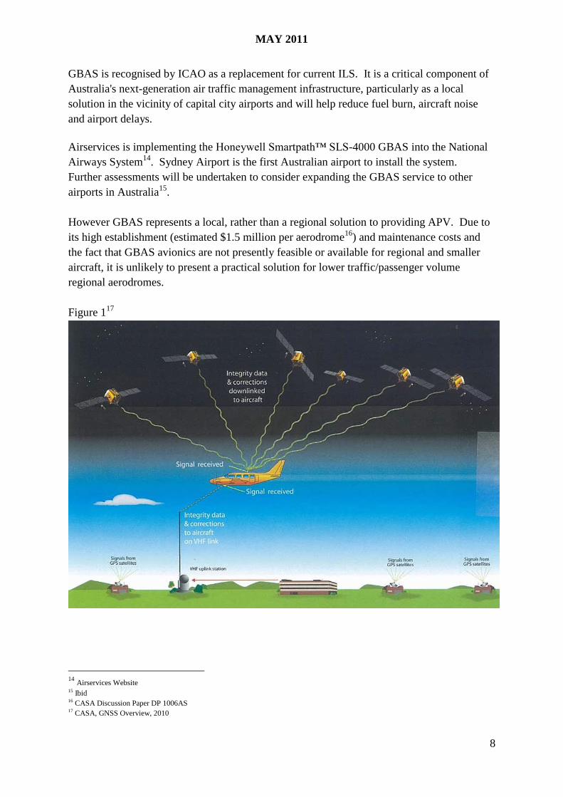
Ground Based Augmentation Systems (GBAS)
GBAS is a satellite-based precision approach and landing system that is established at an
airport. As shown in Figure 1, a ground station at the airport transmits locally-relevant
corrections, integrity and approach data to aircraft in the terminal area via a VHF (radio)
band. GBAS provides aircraft with very precise positioning guidance, both horizontal and
vertical, which is especially critical during the approach and landing phase of flight. This
allows for a safer, more efficient descent and landing.
13 QNH: Altimeter subscale setting to obtain elevation or altitude.
MAY 2011
8
GBAS is recognised by ICAO as a replacement for current ILS. It is a critical component of
Australia's next-generation air traffic management infrastructure, particularly as a local
solution in the vicinity of capital city airports and will help reduce fuel burn, aircraft noise
and airport delays.
Airservices is implementing the Honeywell Smartpath™ SLS-4000 GBAS into the National
Airways System14
. Sydney Airport is the first Australian airport to install the system.
Further assessments will be undertaken to consider expanding the GBAS service to other
airports in Australia15
.
However GBAS represents a local, rather than a regional solution to providing APV. Due to
its high establishment (estimated $1.5 million per aerodrome16
) and maintenance costs and
the fact that GBAS avionics are not presently feasible or available for regional and smaller
aircraft, it is unlikely to present a practical solution for lower traffic/passenger volume
regional aerodromes.
Figure 117
14
Airservices Website 15 Ibid 16 CASA Discussion Paper DP 1006AS 17 CASA, GNSS Overview, 2010

MAY 2011
9
Satellite Based Augmentation Systems
Satellite Based Augmentation Systems (SBAS) deliver error corrections, extra ranging
signals (from the geostationary satellite) and integrity information for each GPS satellite
being monitored. Like GBAS it also augments GPS signals to provide aircraft with very
precise positioning guidance, both horizontal and vertical.
However SBAS differs from GBAS in that it provides GPS integrity monitoring via satellites,
rather than from the ground and potentially provides coverage for a wider geographical area.
As shown in Figure 2, in addition to onboard GPS navigation equipment, SBAS comprise:
a network of ground reference stations to monitor GPS signals;
master stations that collect and process reference station data and generate SBAS
messages;
uplink stations that send the messages to the geostationary satellites; and
transponders in the geostationary satellites that broadcast the SBAS messages to the
aircraft.
Figure 218
18
CASA, GNSS Overview, 2010
MAY 2011
10
4. APV, SBAS and Aviation - Overseas Experience
4.1 Background
Currently there are two SBAS systems in operation that are certified for APV approaches -
the US WAAS and the European EGNOS. Others that are currently being implemented
include Japan’s MSAS, India’s GAGAN, Russia’s SDCM and China’s COMPASS.
It is important to examine the experiences of overseas administrations with SBAS
implementation, in order to fully consider the costs, benefits and challenges that Australia
might experience if it were to pursue establishing an SBAS capability.
Overseas administrations have cited the following benefits and reasons for adopting SBAS
for the aviation sector:
Increased accuracy and integrity;
Reducing delays, diversions and cancellations of flights;
Reducing the occurrence of Controlled Flight into Terrain by as much as 75%;
Acting as a backup system for existing precision approaches;
Allowing the design of more flexible and safer approach procedures for rotorcraft;
Enable curved approaches and continuous descent paths, reducing both noise and
emissions;
Improve approaches for helicopters in densely populated areas; and
Reduces air traffic infrastructure costs - cost effective alternative to instrument
landing systems, offering similar performance yet without the need for infrastructure
installation and maintenance.
However, many overseas administrations have and are experiencing lengthy implementation
delays and cost overruns. For example, the cost of the USA WAAS, was originally forecast
at $509 million in 1994 and has now cost over $3 billion dollars. Furthermore, the initial
operating capability was estimated to commence in June 1997, but did not eventuate until
July 200319
.
Also the EGNOS Safety of Life (SOL) certification was expected in 2008, however this
occurred only recently, i.e. within the second half of 2010. The EGNOS SOL service has
only been available since early March 2011. EGNOS has also experienced significant
additional establishment and maintenance costs20
.
19 http://www.gao.gov/new.items/d0511.pdf 20
http://www.insidegnss.com/node/2448

MAY 2011
11
4.2 United States of America – Wide Area Augmentation System (WAAS)
Since 2003, the USA has used WAAS for APV approaches. The Federal Aviation
Administration (FAA) has published approximately 2000 precision-like approaches enabled
by WAAS at more than 800 airports. These Localizer Performance with Vertical Guidance
(LPV) procedures improve access to airports in lower visibility conditions and where
obstacles are present. They are particularly valuable for smaller airports used by general
aviation.
The FAA in its NextGen Implementation Plan 2010 is aiming to maintain the goal of at least
300 new LPV approaches per year, and is working with the aviation community to prioritise
the schedule of runway ends slated to receive LPV procedures.
LPV capability is currently available on more than 30,000 general aviation and
business/regional aircraft equipped with GPS receivers capable of processing WAAS signals
and the USA expects that the WAAS capable equipage will continue to grow into the future.
WAAS is funded by the US Government and managed and regulated by the FAA.
4.3 Canada -WAAS
Canada currently uses the American WAAS for APV. Telesat Canada provides the WAAS
coverage from its Anik F1R satellite. NavCanada built and maintains four reference stations
in Canada that, together with existing USA stations, provide signal coverage throughout
much of Canada.
Twenty-four LPV approaches, supported by WAAS have been published to date. Additional
sites are planned but are dependent upon provision of necessary airport survey data.
4.4 Europe – EGNOS
The European GNSS Navigation Overlay Service (EGNOS) has been developed through a
tripartite agreement between the European Space Agency (ESA), the European Commission
(EC) and Eurocontrol (the European Organisation for the Safety of Air Navigation). The
European Commission now has full ownership of EGNOS. ESA contributed €200 million
(from its Member States and European institutions related to civil aviation and cartography)
and the European Commission €100 million to establish EGNOS21
. Ongoing funding is
provided through the Seventh Framework Programme for Research and Technological
Development.
21
http://www.esa.int/export/esaNA/SEMNGFX5WRD_index_0.html

MAY 2011
12
The European Satellite Services Provider (ESSP) was established in 2001 to operate EGNOS.
In 2007 the GNSS Supervisory Authority was established to manage all public interests
related to European GNSS programmes.
The official start of operations was announced by the European Commission on
1 October 2009. According to the Single European Sky (SES) regulations, the EGNOS
Service Provider (ESSP) has been certified for the provision of the EGNOS safety of life
(SOL) service as of 12 July 2010. The European Commission (EC) authorised the entry into
service of the full SOL service, including vertical guidance application for aviation, in early
March 2011.
Eurocontrol has launched projects in France, the UK and Poland aimed at the operational
implementation of Approach Procedures with Vertical Guidance (APV) using EGNOS.
Other European countries have plans in place for both the use of Baro-VNAV and SBAS.
They have been awaiting certification of EGNOS for vertical navigation before proceeding
with adoption of SBAS to support APV. Europe plans to remove all non-precision
approaches using terrestrial navigation aids by 2016 by adopting satellite based technology.
4.5 Japan - MSAS
MSAS is in its initial operating phase. There are six ground reference stations on the
Japanese Islands, one in Canberra and one in Hawaii. There are two master control stations
and two multifunction transport satellites (MTSAT).
Because of the limited network coverage, MSAS is only certified for lateral guidance at
present. Japan is undertaking a MSAS performance enhancement program which will add
ten additional ground reference stations and a new algorithm developed by its Electronic
Navigation Research Institute (ENRI) to enable vertical guidance by 2014.
Japan is also investing in GBAS at Kansai International Airport and has already adopted
Baro-VNAV enabled APV at selected airports.
4.6 India - GAGAN
Indian Space Research Organization (ISRO) in association with the Airports Authority of
India (AAI) is developing an SBAS, known as GAGAN. GAGAN has a capability to
provide the augmentation service within its footprint, which covers a large portion of the
airspace beyond Asia-Pacific Region, Africa to Australia.
The final operational phase of GAGAN is proposed to provide APV coverage by June 2013.
GAGAN will comprise three geostationary satellites. However, GAGAN’s first satellite
launch in April 2010 was unsuccessful.

MAY 2011
13
GAGAN will comply with ICAO safety-of-life operations and support APV coverage. The
implemented GAGAN shall be compatible and interoperable with other SBAS systems and
provide seamless air navigation services within the Indian region.
In the interim, India is in the process of implementing Ground-Based Augmentation System
(GBAS) approach operations to improve access in low-visibility conditions. This will allow
Category I, II and III precision approaches to non-ILS runways at Mumbai and Delhi.
India is also implementing Baro-VNAV procedures at the maximum possible number of
airports, primarily international airports.
4.7 Russia – System of Differential Correction and Monitoring (SDCM)
SDCM is based on the Russian GLONASS satellite constellation. The baseline 24-satellite
constellation is planned to be deployed in 2011, after which time it will be maintained at that
level by means of group or single-profile launch events. The next generation of “Glonass-K”
spacecraft was launched at the end of February 2011 and aims to provide 99.9% availability
worldwide.
In order to improve SDCM coverage, Russia plans to launch three geostationary satellites
between 2011 and 2013. The ground control augmentation segment is expected to be
extended and modernized by increasing the number of SDCM stations to nine in Russia and
five overseas, including one in Australia.
GLONASS satellites broadcast two types of navigation signals in L1 and L2 frequency
bands: the standard positioning signal and the high accuracy positioning signal22
.
4.8 China - COMPASS
On 14 April 2007, the first Medium Earth Orbit satellite, named Compass-M1, was launched.
On 15 April 2009, the first geostationary satellite, named Compass-G2, was launched.
According to the construction schedule, the Compass/BeiDou Navigation Satellite System
will, as a first step, cover China and the nearby area, in 2011, but the full deployment of the
System is scheduled to be completed between 2015 and 2020.
However, Compass will not be compatible with current GPS receivers, or other SBAS
systems. China does not intend for Compass to broadcast L1-band GPS or WAAS signals, so
SBAS receivers won't be able to use the Compass system without upgrades23
.
22
United Nations, 2010, Current and Planned Global and Regional Navigation Satellite Systems and Satellite-based Augmentations
System
23 http://www.aviationweek.com/aw/jsp_includes/articlePrint.jsp?storyID=news/nextgen0710p05.xml&headLine=null

MAY 2011
14
4.9 Asia Pacific Region
Most other countries, particularly in the Asia Pacific region are facing difficulty in meeting
ICAO’s timelines for implementing APV. In a number of cases member states have not
implemented straight-in approaches, which is a key first step in safety improvement before
considering APV approach coverage. Most Asia Pacific countries have difficulty in adopting
SBAS due to interoperability issues and the lack of access to suitable GNSS augmentation
system capability within the southern hemisphere, in addition to cost considerations and
competing safety priorities.
For example, New Zealand indicated in its Performance Based Navigation (PBN) Plan that
PBN approaches with vertical guidance will be based on Baro-VNAV specifications for the
foreseeable future. Early adoption of SBAS is considered unlikely due to interoperability
issues and the lack of suitable GNSS augmentation systems within New Zealand’s airspace.
Consequently, most countries within the Asia Pacific region will adopt Baro-VNAV as the
preferred method for APV approaches for the short to medium term, with SBAS being
considered for adoption well beyond 2016.
5. SBAS – Operational, Structural and Financial Issues
5.1 Overview
As outlined in Section 3, there are a number of options which can be used to reduce CFIT and
enhance APV coverage in Australia. Depending on the final scope of coverage envisioned,
the vast majority of airports may be covered using one or a suite of technology solutions.
In pursuing an SBAS capability in Australia, indicative costs and benefits were outlined in
the 2009 APV study. These broad indicative costs and benefits, even with any subsequent
variations, and potentially different public/private funding approaches, make it difficult to
justify the significant investment involved in establishing SBAS in Australia to cover aviation
operations at smaller aerodromes at this time.
It is important to note that a greater body of work would need to be undertaken to deliver
high accuracy costings and economic benefits against each of these options – for inclusion in
any submission to the Government to support a final informed decision on whether to
consider progressing an SBAS capability, including whether there were quantifiable benefits
and interest from other industry sectors.

MAY 2011
15
5.2 The required roles and responsibilities of industry, government agencies and other
stakeholders for successful implementation.
There are a number of possible ownership and operational structures Australia could
consider. It ultimately depends on the level of interest and adoption of SBAS by industries
other than aviation, and the type of SBAS adopted e.g. Australian owned, participation in
MSAS, another regional SBAS model or commercial arrangement, etc.
Under an “aviation only” SBAS model, it is highly unlikely that the aviation industry would
seek ownership of SBAS infrastructure, particularly given the main potential beneficiaries of
SBAS, the smaller regional airlines, have the least capacity to fund such a major investment.
The major airlines and airports in Australia already have access to ILS or other systems or
can utilise Baro-VNAV technology without requiring SBAS and hence have no incentive to
invest in SBAS.
Government aviation portfolio agencies are also not likely to take on an ownership role.
Airservices Australia, which provides most civil air traffic services in Australia, is funded by
industry, which as indicated above, would have only a partial interest in funding investment
in SBAS. Airservices already has a major role in resourcing and undertaking approach
design work for vertical guidance procedures over the next four years for the nearly 200
aerodromes where Baro-VNAV capable aircraft are operating public transport services.
CASA is a safety regulatory body not an air traffic service provider, and their role in SBAS
would centre on establishment of regulatory requirements and compliance.
In terms of use beyond aviation and in fact beyond transport, if there was a demand and
willingness to pay which extended to other industries such as agriculture, forestry and
mining, broader consideration would need to be given to which current government agency or
private sector interest would be best placed to manage the development, establishment,
operation and maintenance of such a SBAS capability.
If other industries wish to use SBAS, then SBAS would become a whole of Government
issue, involving a number of Departments and agencies in its development, operation and
final regulatory oversight. This scenario may also necessitate the need to establish a new
entity to manage SBAS issues in Australia.
Similarly, in relation to the Government participating in a joint venture/ capability with
another country or through a commercial arrangement with the private sector, such an
approach would require involvement of departments such as DBCDE, DIISR and DFAT as
well as extensive negotiations with overseas administrations to test their willingness to
cooperate/participate with Australia in such an arrangement.

MAY 2011
16
5.3 Estimated Costs and Benefits Profile Over the Life of developing SBAS or other
options to complete APV coverage in Australia
Indicative costs for establishing and implementing SBAS in Australia depend on the
operational model adopted, leaving aside ongoing maintenance and operational costs. A
range from over $100 million to approaching $1 billion could broadly be estimated
acknowledging that over time and with different financial and infrastructure options this
range may vary.
Further analysis would be needed to determine the benefits accrued purely from SBAS over
and above those significantly less costly options such as adopting Baro-VNAV.
That is, if other non-aviation users could not demonstrate the need (and therefore benefits) for
SBAS in their industries the additional benefits of the more expensive SBAS options would
only be related to reduced risk to operations at small regional aerodromes which would not be
covered by using Baro-VNAV. Even at the smaller aerodromes the initial focus from a
cost-benefit point of view would likely be on ensuring, wherever possible, all runway ends do
have a straight-in approach.
Care also needs to be taken in making any comparisons with overseas non-aviation benefits
of SBAS if state government and industry have already found (and are funding) alternative
effective ways of using satellite-based technology without the need for the vertical precision
of SBAS.
5.4 An examination of feasible timelines for introduction of a SBAS or other capability and
risk management.
In 2007 the original ICAO Resolution A36-23, required all member states need to implement
APV at all instrument runway ends that serve aircraft with a mass of 5,700kg or more in line
with the following deadlines:
30% by 2010;
70% by 2014; and
100% by 2016.
However at the 37th
ICAO assembly meeting in October 2010, a new Resolution was passed
which represents an acknowledgement that few member states will be able to implement
APV coverage within the given ICAO timeframes. The change also recognises the primary
safety importance of having straight-in approaches at a wider range of smaller aerodromes.

MAY 2011
17
The resolution now allows for:
implementation of approach procedures with vertical guidance (APV) (Baro-VNAV and/or
augmented GNSS), including LNAV only minima, for all instrument runway ends, either as
the primary approach or as a back-up for precision approaches by 2016 with intermediate
milestones as follows: 30 per cent by 2010, 70 per cent by 2014; and
implementation of straight in LNAV only procedures, as an exception to 2) above, for
instrument runways at aerodromes where there is no local altimeter setting available and
where there are no aircraft with a maximum certificated take-off mass of 5 700 kg or
more suitably equipped for APV operations.
It should be noted that Australia has already implemented straight-in approaches for at least
one runway end, where possible, at most airports serviced by RPT aircraft.
Given the lead times involved in establishing an SBAS capability and noting industry training
and equipment requirements to adopt APV approaches, it is not realistic for Australia to meet
the ICAO full coverage requirements, nor is there an apparent compelling cost benefit case to
do so. Australia’s position is likely to be shared with the majority of countries which have
significant numbers of small aerodromes and by those countries looking to adopt Baro-
VNAV as the primary means of adopting APV approaches.
Australia will need to provide advice to ICAO outlining its position and include its proposed
course of action in terms of the implementation plan for the wider adoption of Baro-VNAV
to provide expanded APV approaches in Australia.
If Australia is to consider SBAS, a realistic implementation plan and timetable would need to
consider a number of issues such as:
the necessity or otherwise of regulatory mandates;
aircraft equipment fitment requirements and adoption rates and training requirements;
regulatory amendment and approval processes;
approach design and approval;
potential negotiations with other countries and/or private operators on access to their
satellite facilities, including talks with neighbouring countries over the possibility of a
regional SBAS; and
responsibility and funding for building and maintaining necessary infrastructure such as
ground reference stations.
In terms of risk management, Australia had 27 CFIT accidents and incidents from 1996-2005,
with most occurring in the general aviation sector. The main commonalities in CFIT incidents
were:
approach to the aerodrome with instrument flight rules;
reduced visibility;

MAY 2011
18
hilly/mountainous terrain;
visual flight rules with visual meteorological conditions; and
pilots tracking off-course24
.
However, since 2006, Australia has only had one fatal CFIT accident (in 2007), which
occurred under visual flight rules. There have been no fatal CFIT accidents operating under
instrument flight rules since 200625
.
Australia has straight-in approaches at around 260 aerodromes, which significantly reduces
the risk of a CFIT accident. As indicated in Section 3.1, ICAO CFIT studies have shown that
straight-in approaches are some 25 times safer than circling approaches.
Added to the proposed adoption of Baro-VNAV to achieve APV approaches covering most
passenger traffic in Australia, there is already a significant commitment to risk mitigation for
CFIT without the need for SBAS at this time.
5.5 Possible Funding Options
Indicative costs for establishing and implementing SBAS in Australia depend on the
operational model adopted, leaving aside ongoing maintenance and operational costs. A
range from over $100 million to approaching $1 billion could broadly be estimated
acknowledging that over time and with different financial and infrastructure options this
range may vary.
The current aviation funding model for air traffic facilities involves industry funding through
Airservices Australia’s enroute and terminal navigation charges. Even spread out over the
five year long term pricing model used by Airservices, the cost of SBAS would represent a
dramatic increase in charging for regional aviation.
This funding model presumes Airservices would become the service provider of SBAS
infrastructure – an assumption which currently has no basis given the already extensive
Airservices infrastructure program including the replacement of critical safety assets.
In addition, Airservices would need to do a funding case for supporting such investment
without a regulatory mandate from CASA. As large sectors of the aviation industry are
unlikely to support such investment, the aviation funding case would be difficult to sustain.
If a private or other entity became the provider of SBAS to aviation, then another charging
mechanism would be needed to fund the initial investment and ongoing cost of SBAS
infrastructure. Again, if it was only to be funded by aviation users, a sustainable funding
mechanism is unlikely to be established.
24
CFIT: Australia in Context 1996 – 2005, ATSB - http://www.atsb.gov.au/publications/2007/b20060352.aspx 25
ATSB data

MAY 2011
19
If SBAS could attract other industries to support its establishment and operation, then either a
new Government or private entity could seek to manage SBAS with a higher possible future
funding stream from multiple users.
However the risk involved in establishment would be whether that entity could lock-in
potential SBAS users to underwrite the significant establishment costs involved. It is
ultimately up to private entities whether they wish to pursue this type of investment.
A detailed cross industry justification and cost benefit analysis for considering SBAS would
need to be provided to the Government if it were to consider any form of investment in
SBAS, including any negotiations with regional partners who might also be interested in
SBAS. There would also need to be considerable work on examining what sort of
Government agency would need to be established to pursue such an investment, including the
issue of establishment and ongoing costs and the level of possible involvement of the private
sector.
5.6 Possible Future Alternatives
There are a number of other considerations that Australia should have regard to in the
possible development of an SBAS capability. Recently, a new satellite was launched by the
US Defence Force providing dual frequency SBAS, which improves signal accuracy and
coverage.
There are also many new satellites and augmentation systems that will be launched in the
future which are predicted to increase GNSS coverage in Australia. These advances may
reduce infrastructure requirements and costs for the development of SBAS in Australia and
could also reduce the need for SBAS in the future.
Multi-GNSS
It is estimated that by 2015, if the planned deployments go ahead, there will be up to three
times the number of satellites and four to six times the number of individual signals on which
measurements can be made. The more satellites and signals there are, the better the
positioning performance is – in terms of accuracy, availability, reliability and integrity26
.
The plan is to eventually have the following satellites in orbit between 2015 and 2020:
GPS (the current 31 satellite constellation);
Russia - Glonass (planned 24 satellite constellation);
Europe - Galileo (planned 30 satellite constellation);
China - Compass (possible 27 satellite constellation);
India - RNSS (possible 7 satellite constellation); and
26
Dempster & Rizos, 2009, Multi-GNSS report

MAY 2011
20
Japan - QZSS (3 satellite constellation). 27
As shown in Figure 3, the average number of satellites in the Australasian region will be over
40. The maximum number of visible satellites is close to 6028
.
Figure 329
Average number of visible satellites (15° elevation cutoff angle) of the GPS, Glonass, Galileo, Compass, WAAS, EGNOS, QZSS, MSAS, IRNSS and GAGAN constellations on a worldwide basis over a 24 hour period.
In addition to increased satellite coverage, on 27 May 2010 the US Air Force successfully
launched a new satellite that contains a new third GPS signal known as L5. L5 is broadcast
in a radio band reserved exclusively for aviation safety services and radio navigation satellite
services. The L5 signal is designed to support safety-of-life transportation and other high-
performance applications. Future aircraft will use L5 signals in combination with L1 C/A
(also in a protected band) to improve signal accuracy30
.
Both L1 and L5 will be used for basic GPS and SBAS in the coming years because a dual-
frequency approach helps to compensate for ionospheric signal distortion, an atmospheric
anomaly made particularly troublesome by the location of the earth's magnetic equator31
.
A recent study32
conducted on dual frequency demonstrated that with increased satellite
coverage and dual frequency, APV coverage can be established with comparatively sparse
ground reference networks in Australia.
27 Ibid 28 Ibid 29
Ibid 30 United Nations, 2010, Current and Planned Global and Regional Navigation Satellite Systems and Satellite-based Augmentations System 31 http://www.aviationweek.com/aw/jsp_includes/articlePrint.jsp?storyID=news/bca0609p2.xml&headLine=null 32 Walter, Enge and Blanch, 2010, Coverage Improvement for Dual-Frequency SBAS Article
MAY 2011
21
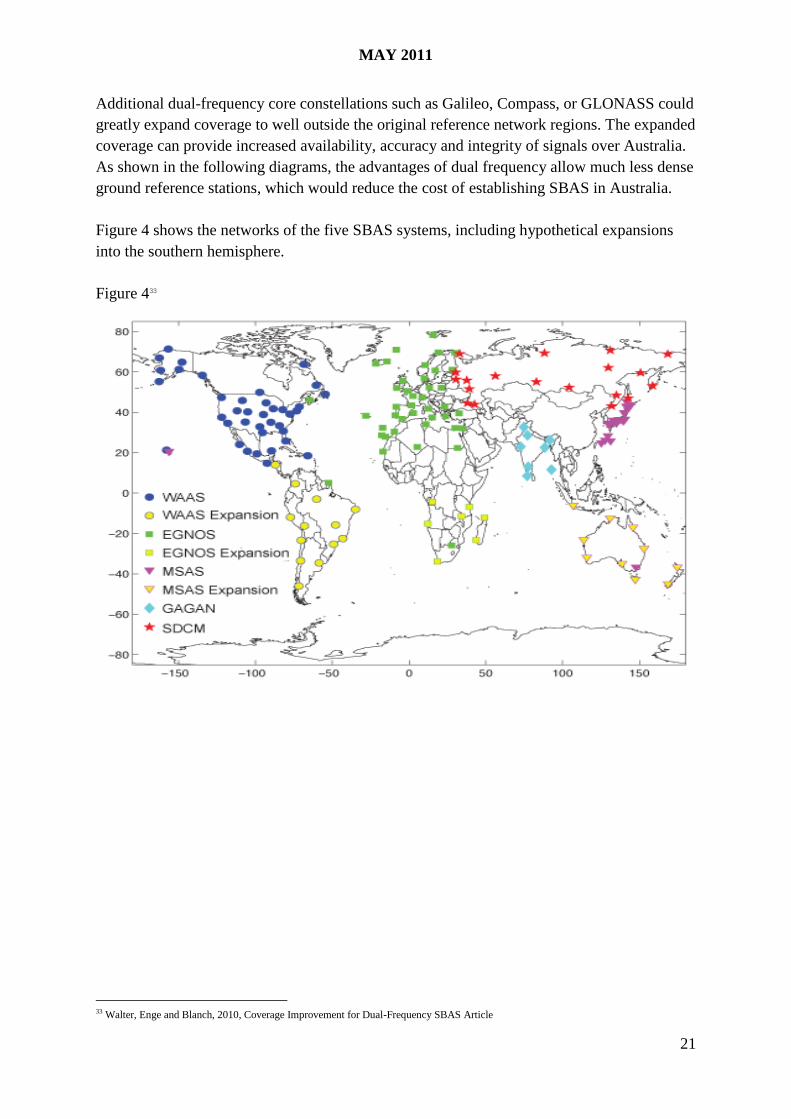
Additional dual-frequency core constellations such as Galileo, Compass, or GLONASS could
greatly expand coverage to well outside the original reference network regions. The expanded
coverage can provide increased availability, accuracy and integrity of signals over Australia.
As shown in the following diagrams, the advantages of dual frequency allow much less dense
ground reference stations, which would reduce the cost of establishing SBAS in Australia.
Figure 4 shows the networks of the five SBAS systems, including hypothetical expansions
into the southern hemisphere.
Figure 433
33 Walter, Enge and Blanch, 2010, Coverage Improvement for Dual-Frequency SBAS Article

MAY 2011
22
Figure 5 shows the combined dual-frequency APV coverage for these SBASs with the
expanded ground reference stations.
Figure 534
34 Walter, Enge and Blanch, 2010, Coverage Improvement for Dual-Frequency SBAS Article
MAY 2011
23
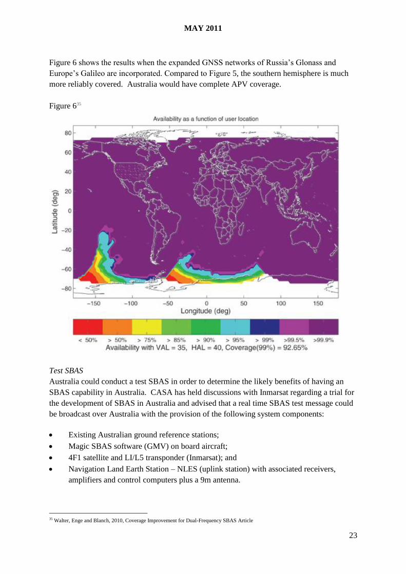
Figure 6 shows the results when the expanded GNSS networks of Russia’s Glonass and
Europe’s Galileo are incorporated. Compared to Figure 5, the southern hemisphere is much
more reliably covered. Australia would have complete APV coverage.
Figure 635
Test SBAS
Australia could conduct a test SBAS in order to determine the likely benefits of having an
SBAS capability in Australia. CASA has held discussions with Inmarsat regarding a trial for
the development of SBAS in Australia and advised that a real time SBAS test message could
be broadcast over Australia with the provision of the following system components:
Existing Australian ground reference stations;
Magic SBAS software (GMV) on board aircraft;
4F1 satellite and LI/L5 transponder (Inmarsat); and
Navigation Land Earth Station – NLES (uplink station) with associated receivers,
amplifiers and control computers plus a 9m antenna.
35 Walter, Enge and Blanch, 2010, Coverage Improvement for Dual-Frequency SBAS Article
MAY 2011
24
Inmarsat has 4 NLES in the region with varying availability (Indonesia, Philippines, Australia
and Auckland). The fully available antenna is 8.1m (transmission requirements TBC) and is
located in Batam, Sekupang, Indonesia. The remaining three NLES could be available on a
shared basis but excess capacity would need to be determined and such a solution could be
technically challenging.
An alternative solution would be a purpose built NLES which is estimated at US$1.5m,
comprising a HDA - RFU system (computer racks that comprise the uplink station capability
are estimated at US$1.0 million) and 9m antenna is estimated at US$500,000 (although if
there was an appropriate antenna available for shared use elsewhere this could conceivably be
used).
A purpose built NLES could be dedicated to research and development of an SBAS
correction message tailored for Australian ionosphere conditions. The provision of a real
time SBAS correction message would not only enable research, test and development of
SBAS signals under Australian conditions but would permit the uses of the test message in
trials for transport modes and industries. However, it is important to note that this test SBAS
signal would not be suitable to test for aircraft APV approaches.
The trial would however, provide data and end user feedback that could inform future
decisions regarding the value of a future SBAS capability acquisition, such as ground
reference station locations.
This interim measure however does not resolve the ownership, management and funding of
the eventual cost of an SBAS capability and whether such investment is justified.
6. SBAS – Non-Aviation Issues
6.1 Australia’s National Space Policy
The Space Policy Unit within the Department of Industry, Innovation, Science and Research
(DIISR) is developing a National Space Policy to provide a vision for Australia's use of space
and space-related technologies including providing strategies to enable Australia to meet its
National Priorities through space and to ensure Australia meets its future space-related
education and innovation needs.
It will have a particular focus on the areas of earth observation, satellite communications, and
position, navigation and timing applications which are key strengths for Australia.
The National Space Policy will also have a significant role in coordinating the space activities
of government on the national, state and, importantly international stage. The policy will
express that international collaboration is vital to Australia's space efforts, as Australia is
reliant on the space systems of our international friends and partners. The challenge is
assuring this access to these systems.

MAY 2011
25
The Policy will consider mechanisms to assure access to these space systems that provide
data that the remote sensing and wider Earth observation community requires. The Space
Policy Unit is aiming to deliver the National Space Policy to Government later this year.
In relation to SBAS, the National Space Policy may provide a broader context for
Government in its consideration of whether there is merit in any further work on an SBAS
capability for Australia, especially given that any viable SBAS proposal in Australia would
require cross portfolio Government and industry support, in addition to potential bilateral and
multilateral discussions with other countries in the Asia-Pacific region.
6.2 Other Users – Land and Maritime Transport and Other Industries
GNSS Ground Based Augmentation Systems in Australia
Many other Australian industry sectors currently use Continuously Operating Reference
Stations (CORS), which is a continuously operating survey quality GNSS Reference Station,
also known as a ground based augmentation system.
CORS continuously record, distribute and archive GNSS satellite data and when used in
conjunction with a second roving GNSS receiver enables the roving unit to accurately
determine its position. Unlike SBAS which provides vertical navigation, it only provides
horizontal navigation capability.
A 2010 Tasmanian Government CORS Feasibility Study36
provides a useful summary of
current activity in different industries in this area.
Agriculture
Agriculture currently represents the fastest growing sector using GNSS. GNSS is currently
used in agriculture for a number of applications described as “Precision Agriculture”. These
include machine guidance, yield mapping, variable rate application of inputs (fertiliser, seed,
water, etc.) and digital elevation mapping.
While machine guidance is the most widely adopted application, the technology is essential
to the implementation of Controlled Traffic Farming (CTF), a technique that involves
constraining the movement of tractors to permanent wheel tracks year after year by fitting
tractors with GNSS steering guidance.
Construction and Civil Engineering
The predominant use of GNSS in this sector is for machine guidance for the building of
roads, highways, rail, bridges and water and electricity infrastructure. As with other sectors,
there is an increasing uptake in the use of the technology, with most major suppliers
experiencing growth in sales of precision machine control systems.
36 SKM, 2010, Feasibility Study- CORS Network Tasmania
MAY 2011
26
Mining
The use of GNSS for accurate selective mining is well established. The application involves
the fitting of GNSS equipment to excavators to allow precise positioning of equipment for
dig operations.
Surveying & Spatial Industry
The surveying and spatial industry use GNSS in all areas of operation and are the most
advanced users.
Science & Research
Real time and static GNSS data is critical to the execution of many current and future
scientific research programs. GNSS data, combined with other forms of observations,
contribute significantly to research into global climate change, sea level studies, modelling of
the upper atmosphere in relation to storm and weather prediction, crustal strain and seismic
deformation, and surface expression of hydrologic loading.
Maritime
The Australian Maritime Safety Authority (AMSA) operates 16 CORS which broadcast a
GPS augmentation (DGPS) service for coastal shipping around Australia as part of their
international commitments to the safety of marine navigation.
Rail
The Australian Rail Track Corporation, the Australian Government-owned national rail track
manager, is trialling the Advanced Train Management System (ATMS) to increase the safety,
capacity and efficiency of the national rail network. The ATMS is designed to use the
existing Global Positioning System (GPS) and Broadband Data and Voice communication
technology. If successful, the ATMS trial would replace ageing and disparate physical train
control and signalling systems.
The trial of the system is taking place on a section of track between Crystal Brook and Port
Augusta in South Australia. If the trial is successful it would provide opportunities for
industry participants in the implementation phase.
Road
In regard to road transport, the Australian Government is examining the use of satellite
technology in the following areas:
progressing the Council of Australia Government’s heavy vehicle pricing and
regulatory reforms, which will potentially include the monitoring of heavy vehicle
movements on national and state road networks.
In-Vehicle and At-Roadside Technology and Intelligent Speed Assist as well as specific
technology standards for future innovative products.
The Australian Government has initiated a Parliamentary inquiry into smart infrastructure,
covering the transport, communications, energy, and water sectors. The committee is
expected to reconvene in the first half of 2011 and is likely to cover the use of GNSS for road
transport. Currently most road transport systems are based on standard GPS systems.
MAY 2011
27
6.3 Future Demand from Land and Maritime Transport and Other Industries
Most State Governments are currently undertaking studies to consider further developing
their CORS network or have already started investing in new CORS infrastructure.
AuScope, a National Collaborative Research Infrastructure Strategy funded project to
enhance Australia’s ability to monitor the Australian continent will build over 100 GNSS
Continuously Operating Reference Stations (CORS) by collaboration between Geosciences
Australia and state governments.
The Department of Agriculture, Fisheries and Forestry (DAFF) and the Australian Maritime
Safety Authority (AMSA) have indicated that it is likely both the agriculture and maritime
industry will continue to use CORS as their primary GNSS position navigation timing
system. A strong interest in using or funding an SBAS capability has not been identified in
these sectors. Furthermore, AMSA has advised that it is currently upgrading its ground based
augmentation system network, based on differential GPS.
The road and rail areas within the Infrastructure and Transport portfolio have advised that
there does not seem to be a strong desire within these industries to have satellite based
augmentation systems.
Whilst SBAS would provide some benefits to these industries, it is clear that all these
industries are continuing to invest in ground based augmentation systems for GNSS
applications rather than considering satellite based augmentation systems. This is most likely
because these industries, unlike the aviation industry, do not currently need the added benefit
of vertical guidance provided by satellite based augmentation systems, nor the level of
accuracy or high availability and integrity that SBAS offers.
6.4 Overseas Experience
There are a number of examples overseas where multiple users of SBAS have been
established. For example, in Europe, EGNOS is being used by a number of industries,
including, agriculture, maritime, aviation, rail and road.
It seems that EGNOS is mainly being adopted in the agriculture and road
planning/monitoring (toll charges) industries. The European rail traffic management system
uses GPS via a mobile communication service provider and radio communication. Despite a
number of studies, there do not appear to be any plans to upgrade the system to EGNOS.
Furthermore there does not seem to be a significant adoption of the American WAAS by
industries other than aviation. American agricultural machinery company “John Deere” has
developed an SBAS system for precision farming known as the StarFire navigation system.
StarFire is considerably more accurate than WAAS due to a number of techniques that
improve its receiver-end processing, but is only used for horizontal navigation.

MAY 2011
28
7. Conclusion
On the basis of information currently available, it is difficult to justify the significant
investment involved in establishing SBAS in Australia to cover aviation operations at smaller
aerodromes at this time.
The review notes a number of new satellites and augmentation systems will be launched in
the future, which are predicted to increase satellite coverage over Australia. These advances
will have implications for future requirements and costs of SBAS in Australia and may
provide access to other alternative systems.
Consideration of any future investment in SBAS would need to be a part of a whole of
Government approach with the significant cost considered against potential benefits across a
range of industries.
Further detailed work would be needed if the Government wished to consider further advice
on an SBAS capability in Australia. This could include a detailed cost benefit analysis,
undertaking a comprehensive SBAS industry demand survey; examining different funding
options including private investment; the impact of increased satellite coverage and new
technologies in the coming years from other countries and the implications of entering into an
agreement or partnership with other countries in the region for satellite access.
However, the review supports proceeding in the short-term with the development of a Baro-
VNAV implementation plan, a more affordable and currently available technology which can
provide APV coverage for over 97 percent of IFR passengers in Australia if implemented
across all aerodromes serviced by Baro-VNAV capable aircraft. Potentially the use of Baro-
VNAV could provide APV coverage at nearly 200 aerodromes throughout Australia.
There are a range of resourcing and cost implications that need to be progressed by
Government agencies in consultation with industry to ensure the extension of APV coverage
in Australia.
The possible future establishment of an SBAS capability in Australia in the long-term
therefore remains open. If strong multi-sectoral demand were to emerge over the coming
decades and SBAS coverage provided by other administrations were to expand significantly
in the region then the efficacy of establishing an SBAS capability in Australia could be
further examined.
MAY 2011
29
Attachment A
SBAS REVIEW – Terms of Reference
Specifically, the review will need to critically examine and report on:
1. The justification and cost of the development of a SBAS capability, or other options,
for completing APV coverage in Australia - in the context of a commitment to
increased use of Baro-VNAV systems, and other current and future means of
implementing safer flight approach paths particular at regional aerodromes
(a) having regard to ICAO’s APV milestones and objectives, and to mitigate controlled
flight into terrain (CFIT) events
2. The review will consider:
a. Australia’s National Space Policy;
b. the demand and potential involvement of other transport modes and other
portfolios for utilising a national SBAS capability, looking at any relevant
experiences of overseas administrations; and
c. possible SBAS ownership, operational and regulatory oversight structures.
3. The review will examine:
a. the required roles and responsibilities of industry, government agencies and
other stakeholders for successful implementation, e.g. infrastructure,
equipment and personnel investment;
b. estimated costs and benefits profile over the life of developing SBAS or other
options to complete APV coverage in Australia;
c. feasible timelines for the potential introduction of a SBAS or other capability,
including any priority needs in relation to fleet fitment or airports procedures
development;
d. likely risks and risk management requirements involved with developing a
SBAS or other capability in Australia and the need for any interim or
transitional arrangements;
e. possible funding options for establishing and operating a SBAS or other
capability in Australia.