IDENTIFIKASI KERUSAKAN NISAN KAYU KOMPLEKS MAKAM RAJA-RAJA …

RSA Raja Abdullah

Introduction/Objectives
Scope and Implementation Plan
Site Description
Sensors
Network Architecture
Roles of Agencies
PoC Outcomes
Issue
Advantage
Conclusion

Hillside development has resulted in the increasing occurrence of landslides in Malaysia
Landslides have occurred not only in residential areas but also at highways, resulting in loss of lives and economic hardship to the public, authorities and government
•To showcase WSN technology for slope monitoring
•To develop an effective landslide hazard monitoring, predictive and analytical system by utilizing WSN motes - real time data can be accessed remotely.

Date of Occurrence Landslide Location Fatality Injury Highway Closure
11 Dec 1993 Highland Tower 48 - -
30 Jun 1995 Genting Sempah 20 22 -
6 Jan 1996 Km 303.8, Gua Tempurung 1 - YES
29 Aug 1996 Pos Dipang, Perak 38 - -
20 Nov 2002 Hillview 8 - -
26 Oct 2003 Km 21.8, Bukit Lanjan - - YES
12 Oct 2004 Km 303, Gua Tempurung - 1 YES
31 May 2006 Zooview 4 - -
17 Jan 2008 Plantation at Comeron Highlands 3 - -
6 Sept 2008 Teluk Bahang, Penang YES
15 Oct 2008 Pinggir Bukit Segar, Cheras, Selangor - - YES
17 Oct 2008 Ganesan Quarry, Hulu Langat,Selangor 2 - -
19 Oct 2008 Sungai Kayu Ara in Petaling Jaya, Selangor, - - -
30 Nov 2008 Ulu Yam Perdana near Kuala Kubu Baru, Selangor 2 - -
4 Dec 2008 Jalan Semantan, Kuala Lumpur. - - -
6 Dec 2008 Bukit Antarabangsa, K. Lumpur 5 15 -
SAFETY IMPACT

NATIONAL SLOPE MASTER PLAN
Develop a national landslide hazard monitoring, prediction and early warning
system.
Develop real-time monitoring and prediction capabilities on both site specific
and regional scales, to assist Federal, State, and local emergency managers
determine the nature of landslide hazards and the extent of ongoing risks.
Propose latest available technologies and application framework for monitoring
landslide movement nationwide.
Propose state-of-the-art techniques with respect to real-time monitoring for
incorporation with slope stability models.

National Monitoring Centre for Slope

Km 21.8, Bukit Lanjan
Taman Zooview
Pos Dipang, Perak
Bukit Antrabangsa, K. Lumpur
Sungai Kayu Ara,PJ Selangor,

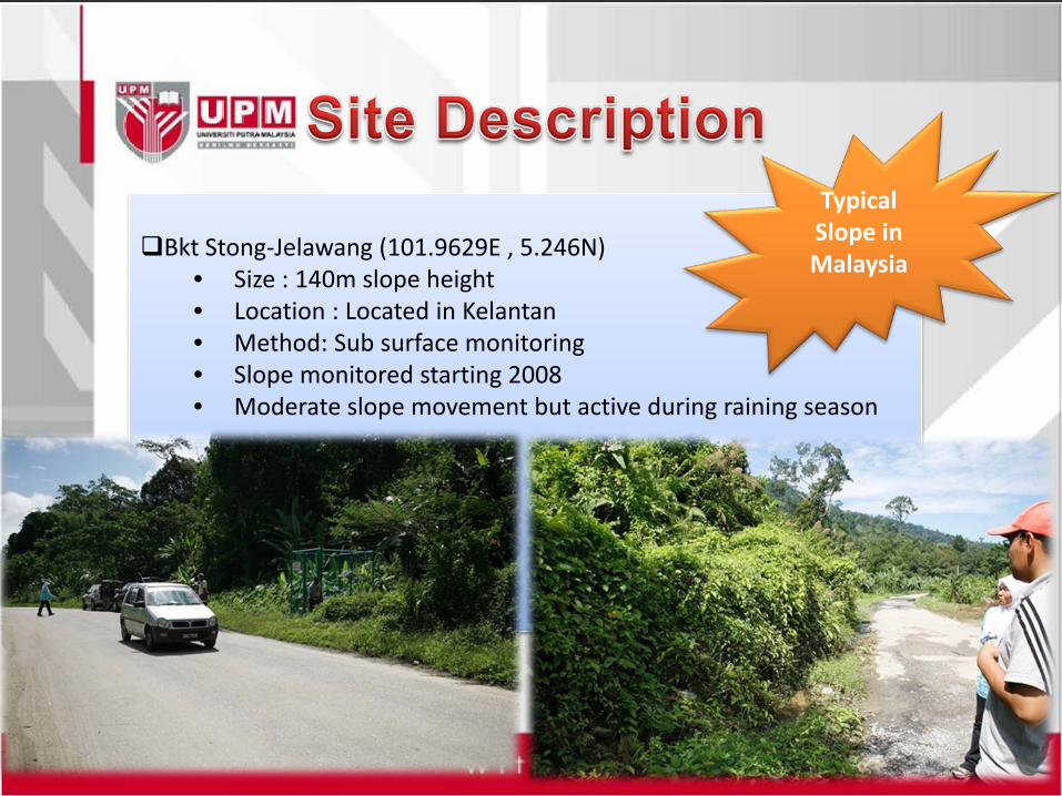
Bkt Stong-Jelawang (101.9629E , 5.246N)• Size : 140m slope height• Location : Located in Kelantan• Method: Sub surface monitoring• Slope monitored starting 2008• Moderate slope movement but active during raining season
Typical Slope in Malaysia

Rain gauge (RG)•Capturing rainfall data
Vibrating Wire Piezometer (VWP)•Measure pore water pressure
Soil Moisture•Monitor soil suction In Place Inclinometer (IPI)
•Sub surface soil movement
-1 hour data granularity-

6 sensors were chosen
Each sensor node configured with1 hour data granularity
Network architecture based on pointto point connection (sensor node-gateway)
Point to point connectivity to longer battery power at sensor node (sleep mode)

Gateway
Radio Communication to Gateway
RG
Gateway sends data to server via satellite SMS RG - Rain Gauge
VWP - Vibrating WirePiezometer
IPI - In-Placed Inclinometer
VWP
VWP
VWP
Soil Moisture
IPI
GSM phone collocated at DB & Application server
WWW
Thuraya Satellite
End UserPWDMICCLocal Authority
SMS

Entities Roles & Responsibility
National CoE Coordination of WSN Slope Monitoring implementation.Network and system architecture designSensor node interface design and integration
PWD-Slope Department To provide Slope Master PlanTo provide list of critical slope for monitoringGovernment policy on Slope monitoring methodology & techniqueInterface between National CoE to current contractor
MICC To provide backbone communication for WSNMain coordinator for WSN implementation
System Integration Company Local industry expertise in WSN technologyDevelopment and integration of Slope Monitoring PoC
Instrumentation Company To provide details sensor specification for WSN development
Telecommunication Service Provider To provide telecommunication infrastructure

Non line of sight for radio transmission
Power scavenging issue that require alternative power
Eg. Solar panel
Canopy clearance required for solar panel
Sensor output sharing capability between Data Logger &
Sensor Node
Lack of electricity communication backbone
Data delivery model & aggregation
The cloudy weather and thick fog limit sunshine for solar
panel at hill side area

Continuous slope monitoring
On line slope monitoring that could be accessed via Internet
Trend of various type of sensor information, sensor node
health & battery condition
Could prevent landslide with the Decision Support System
implemented which save life and contribute to economic
stability
A reference model for other disaster prone country
• Slope monitoring is one of the critical application that could be supported by WSN
• 24x7 monitoring is the main advantage by implementing WSN Slope Monitoring
• The successfully of WSN Slope Monitoring to be implemented nation wide depends on government and authority policy.