Rozelle-Annesdale Plan for Growth and Development
49
Rozelle-Annesdale Plan for Growth and Development Rozelle-Annesdale Neighborhood Association Memphis/Shelby County Division of Planning & Development June, 2005
Transcript of Rozelle-Annesdale Plan for Growth and Development
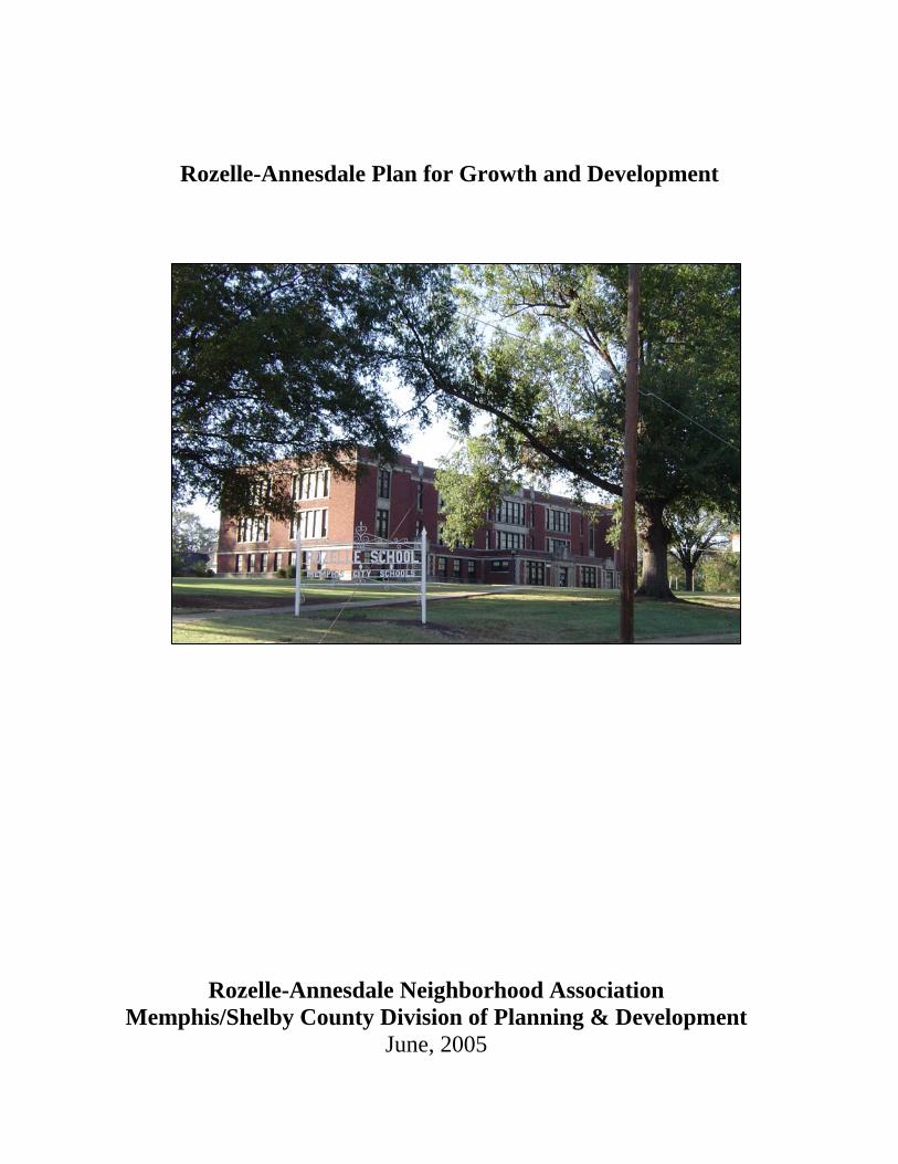
Rozelle-Annesdale Plan for Growth and Development
Rozelle-Annesdale Neighborhood Association Memphis/Shelby County Division of Planning & Development
June, 2005
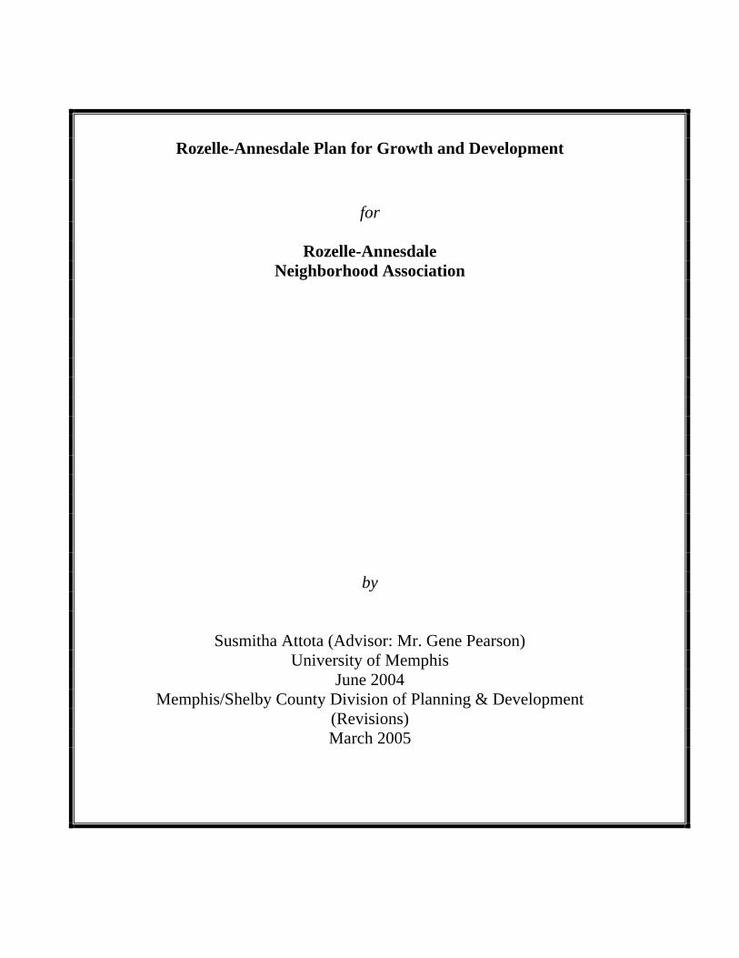
Rozelle-Annesdale Plan for Growth and Development
for
Rozelle-Annesdale Neighborhood Association
by
Susmitha Attota (Advisor: Mr. Gene Pearson) University of Memphis
June 2004 Memphis/Shelby County Division of Planning & Development
(Revisions) March 2005

i
Table of Contents
Chapter Page Table of Contents i
List of Tables ii
List of Maps ii
I. Introduction 1
A. Purpose and Scope 1
B. Description of the neighborhood 1
C. Organization of report 4
II. Neighborhood History and Previous Plans 5
A. History 5
B. Previous plans 8
III. Conditions and Trends 12
A. Population Trends 12
B. Housing Trends 15
C. Current Land Use and Zoning 16
D. Structural and environmental conditions 21
E. Design Character 26
F. Planning Issues 27
IV. Plan Concept 29
A. Development Plan Goals for 2010 29
B. Plan Proposals 29
V. Organization for Action 36
A. Neighborhood Organization 36
B. Commercial Area Development 37
C. Public Facility Investment 38
D. Housing Development 39
E. Land Use Regulations 41
F. Conclusion 42
References.. 43
ii
List of Tables Table No. Page 1 Year Structure Built 3 2 Total Population 8
3 Age of Population 9
4 Average Household Size 9
5 Education Attainment 10
6 Employment 11
7 Income and Poverty 11
8 Housing 12
9 Housing Value 12
10 Occupancy 13
11 Structural Conditions 15
12 Lot Conditions 15
13 Properties for Potential Growth 17
List of Maps Map No. Page
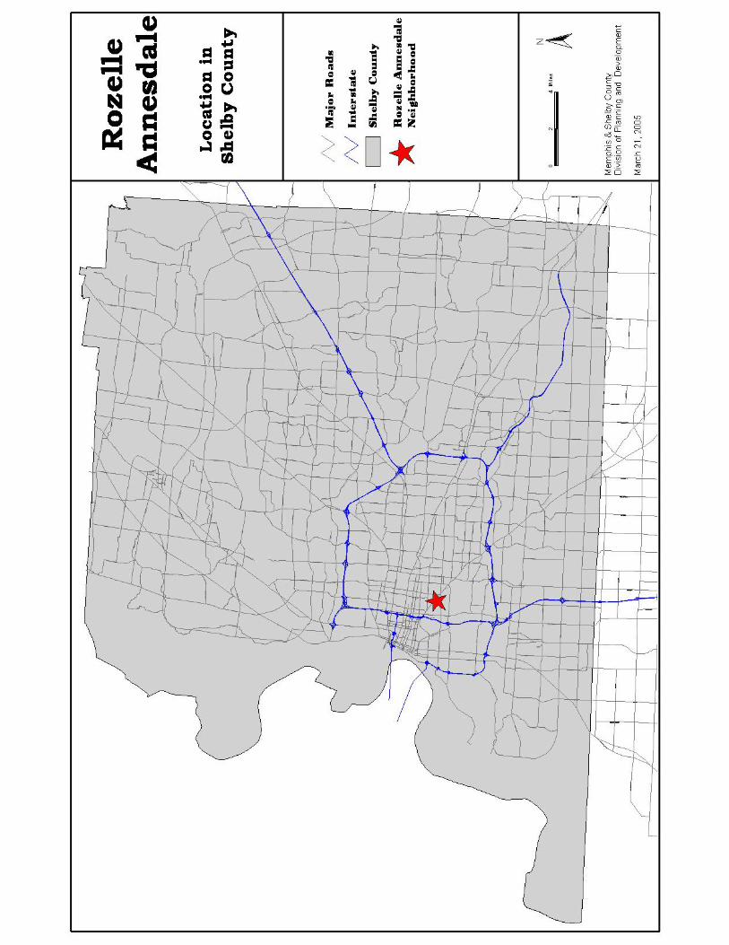
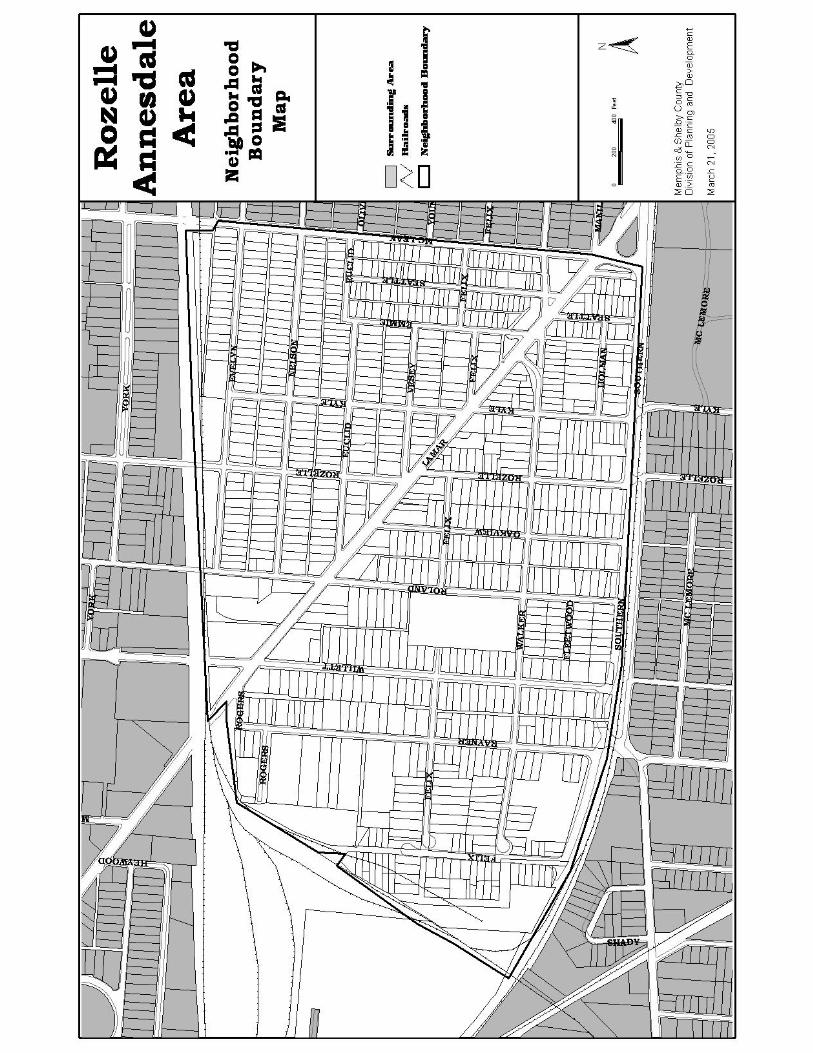
1 Location of Rozelle-Annesdale 2
2 Rozelle-Annesdale Neighborhood Boundaries 3
3 Year Structure Built 6
4 Existing Land Uses 17
5 Vacant Land 20
6 Land Use and Zoning 22
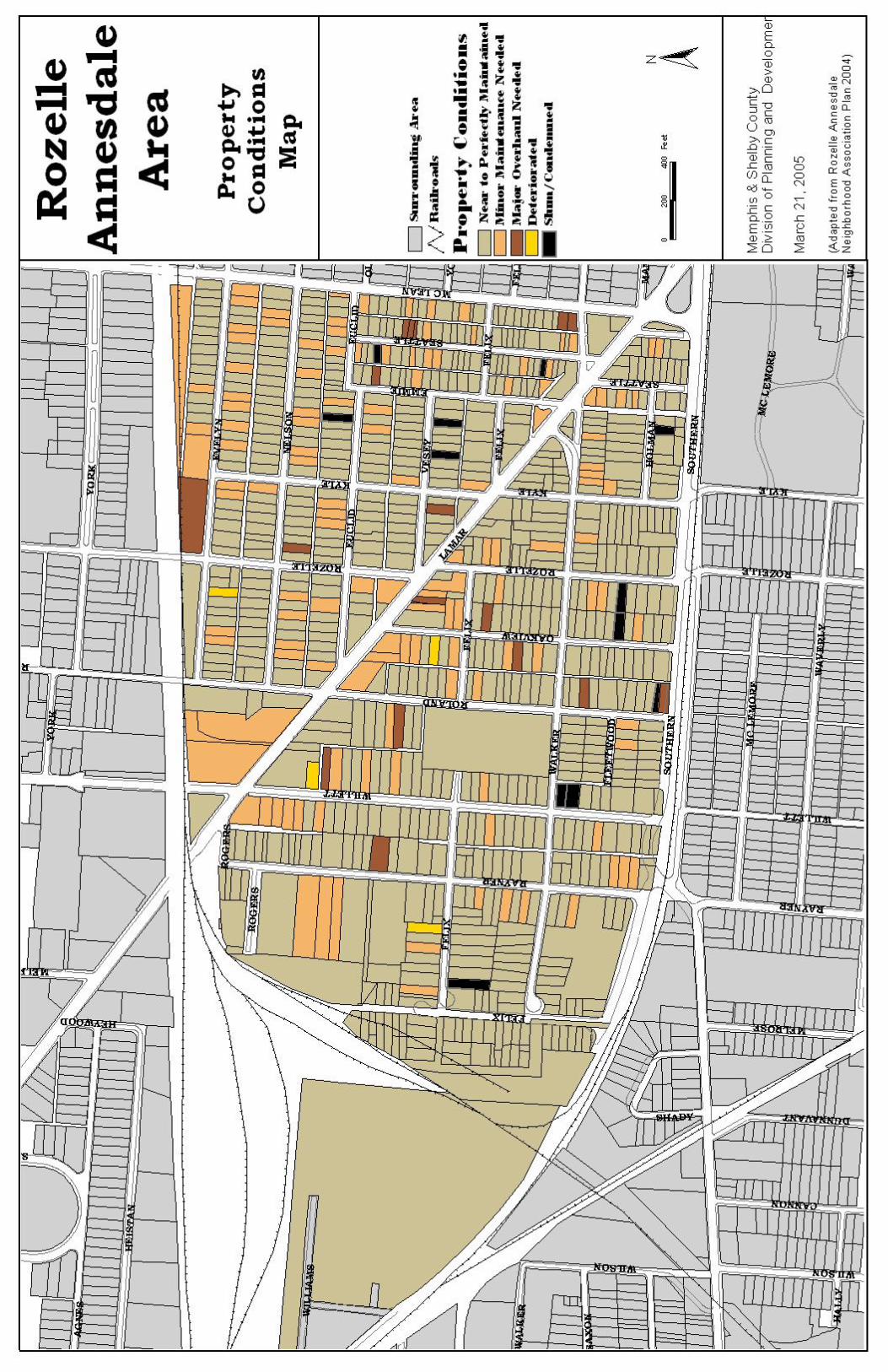
7 Property Conditions 24
8 Land Use Alternative 35
1
I. INTRODUCTION
A .Purpose and Scope
The purpose of this report is to provide a plan for the Rozelle-Annesdale neighborhood that
can be used by the community members to present to local government officials.
A general development plan which contains recommendations for public facility
improvements and land development is thus presented in this report based on the past and current
trends. It is intended to achieve recommended development in the neighborhood with the help of
this plan by the year 2015.
This plan focuses only on the physical development of the neighborhood. Other issues such
as prevention of crime in the neighborhood (which was identified in the neighborhood meeting)
are partially covered by this plan and require additional research, which is not included in the
scope of this report.
Also a separate report on comprehensive rezoning of the neighborhood is provided along
with this report, in order to implement the land use recommendations of this plan.
B. Description of the Neighborhood
Rozelle-Annesdale is located in the Midtown Planning District of Shelby County. For the
purpose of this research, the study area is defined by the L & N railroad to the north, the MoPac
railroad to the west, the Southern railroad to the south and McLean Boulevard to the east.
The neighborhood covers a portion of Census Tract 62 and Census Tract 63. The population
and housing trends are analyzed using the data from the census block groups which exactly fit
the neighborhood boundaries.
The neighborhood is centrally located and surrounded by Cooper-Young neighborhood to the
east, Annesdale-Snowden neighborhood to the west, Central Gardens neighborhood to the north
and Glenview neighborhood to the south.
The current pattern of development in the neighborhood is predominantly residential. A
commercial strip exists along Lamar Avenue which bifurcates the neighborhood. Industrial
properties exist along the railroad tracks on the northern and western boundaries of the
neighborhood.
Rozelle-Annesdale boundaries are used by two neighborhood organizations. They are the
Rozelle-Annesdale Neighborhood Association, which was organized in 1973 and the Pigeon
4
Roost Development Corporation, which was
organized in 1985. Both of these organizations
have been inactive for a number of years and have
been recently reorganized to work toward the
neighborhood’s revitalization.
The Cooper-Young Development Corporation
(CYDC) extended its boundaries to include the
portion of Rozelle-Annesdale north of Lamar. It
has built several houses in this area, mainly in the Annesdale section and has plans to build
additional houses in the near future.
C. Organization of the Report
The following chapter presents an overview of the neighborhood’s history and discusses
proposals and outcomes from previous plans for the Rozelle-Annesdale neighborhood. These
proposals and outcomes partly form the basis for defining planning issues of the neighborhood.
The third chapter discusses past and current trends of the neighborhood with respect to
population and housing to determine the potential for future development. The results of the
visual survey are also presented in this chapter to identify the current land uses, and structural
and environmental conditions of the neighborhood. Based on this information, planning issues
for the neighborhood are summarized at the end of this chapter.
The fourth chapter outlines the goals for development based on the planning issues discussed
in the previous chapter; and it concludes with a general development plan for the entire
neighborhood.
Finally the fifth chapter presents steps to be taken to implement this development plan.
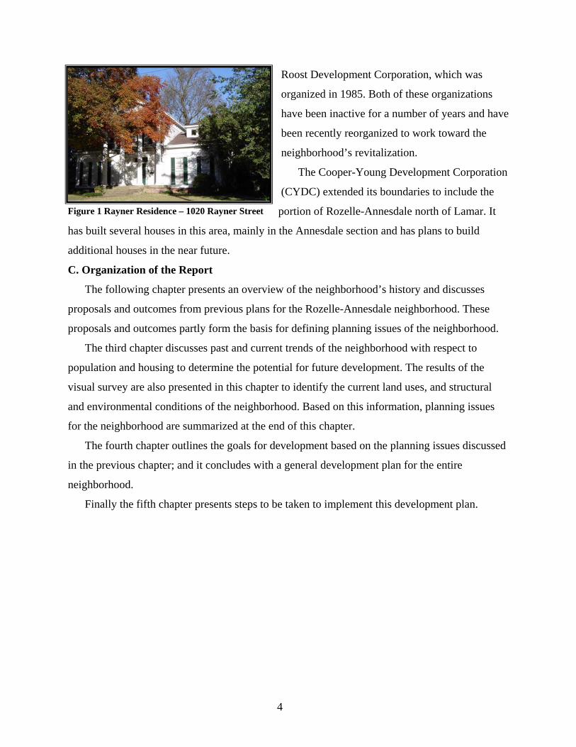
Figure 1 Rayner Residence – 1020 Rayner Street
5
II. NEIGHBORHOOD HISTORY AND PREVIOUS PLANS
This chapter discusses the history of Rozelle-Annesdale and the past and current planning
studies that are relevant for its redevelopment.
A. History
Rozelle-Annesdale is one of the oldest neighborhoods in Memphis with both whites and
blacks living in the same neighborhood over a long period. Its history dates back to the 1830’s
when Solomon Rozelle purchased 803 acres of land a few miles from the fledgling city.
Subsequent purchases extended his holdings to include all of the present-day neighborhood.. He
built his home on the edge of the neighborhood near the present-day junction of Lamar Avenue
and the Southern Railroad . Several structures in the neighborhood are quite old and most were
built before 1940 (See Table 1). Only a few structures were constructed in the past 20 years. Table 1
Year Structure Built
Before 1940 1940- 1980 1980- 2000 Unknown TotalNumber 534 71 35 29 669Percent of Total 79.8 10.6 5.2 4.3
Source: Shelby County Assessors Data
The map, “Year Structure Built,” shows the age pattern of structures in the neighborhood. It
indicates that structures built in the past 20 years are scattered throughout the neighborhood.
Both white and black families settled in the neighborhood during the 19th century. Eli
Rayner was the one of the first to build his house in the neighborhood in 1853. His house is
presently listed on the National Register of Historic Places. (1977)
Pigeon Roost Road , later renamed Lamar Avenue, was an important means of access into
the area well before any settlers arrived, providing the Chickasaw Indians a trail from
Mississippi to the river. It has continued as a major transportation route into and through the
neighborhood and is today a federal highway.
The neighborhood experienced moderate growth in 1850’s and 60’s with a number of homes
being built along Pigeon Roost Road and along the Memphis and Charleston Railroad. In the late
1890’s, many people moved into homes along Lamar Avenue and the introduction of a street car
line furthered development in the neighborhood. Due to the rich history of the area, a variety of

7
housing styles are observed in the neighborhood such as craftsman bungalow, two-story brick
houses and Queen Anne bungalows.
The neighborhood was annexed by Memphis in 1898 but was still considered suburban
property for several years. Commuter trains along the Southern Railroad and street trolleys along
Lamar Avenue were the means of transportation to downtown Memphis. Horse-drawn vehicles
also moved along Lamar Avenue until the turn of the century, when they were replaced by motor
vehicles.
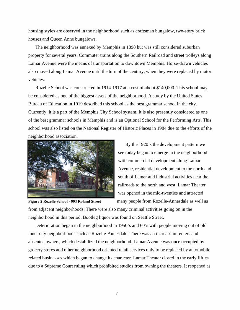
Rozelle School was constructed in 1914-1917 at a cost of about $140,000. This school may
be considered as one of the biggest assets of the neighborhood. A study by the United States
Bureau of Education in 1919 described this school as the best grammar school in the city.
Currently, it is a part of the Memphis City School system. It is also presently considered as one
of the best grammar schools in Memphis and is an Optional School for the Performing Arts. This
school was also listed on the National Register of Historic Places in 1984 due to the efforts of the
neighborhood association.
By the 1920’s the development pattern we
see today began to emerge in the neighborhood
with commercial development along Lamar
Avenue, residential development to the north and
south of Lamar and industrial activities near the
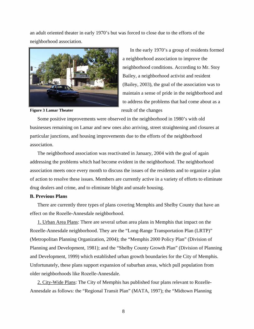
railroads to the north and west. Lamar Theater
was opened in the mid-twenties and attracted
many people from Rozelle-Annesdale as well as
from adjacent neighborhoods. There were also many criminal activities going on in the
neighborhood in this period. Bootleg liquor was found on Seattle Street.
Deterioration began in the neighborhood in 1950’s and 60’s with people moving out of old
inner city neighborhoods such as Rozelle-Annesdale. There was an increase in renters and
absentee owners, which destabilized the neighborhood. Lamar Avenue was once occupied by
grocery stores and other neighborhood oriented retail services only to be replaced by automobile
related businesses which began to change its character. Lamar Theater closed in the early fifties
due to a Supreme Court ruling which prohibited studios from owning the theaters. It reopened as
Figure 2 Rozelle School - 993 Roland Street
8
an adult oriented theater in early 1970’s but was forced to close due to the efforts of the
neighborhood association.
In the early 1970’s a group of residents formed
a neighborhood association to improve the
neighborhood conditions. According to Mr. Stoy
Bailey, a neighborhood activist and resident
(Bailey, 2003), the goal of the association was to
maintain a sense of pride in the neighborhood and
to address the problems that had come about as a
result of the changes
Some positive improvements were observed in the neighborhood in 1980’s with old
businesses remaining on Lamar and new ones also arriving, street straightening and closures at
particular junctions, and housing improvements due to the efforts of the neighborhood
association.
The neighborhood association was reactivated in January, 2004 with the goal of again
addressing the problems which had become evident in the neighborhood. The neighborhood
association meets once every month to discuss the issues of the residents and to organize a plan
of action to resolve these issues. Members are currently active in a variety of efforts to eliminate
drug dealers and crime, and to eliminate blight and unsafe housing.
B. Previous Plans
There are currently three types of plans covering Memphis and Shelby County that have an
effect on the Rozelle-Annesdale neighborhood.
1. Urban Area Plans: There are several urban area plans in Memphis that impact on the
Rozelle-Annesdale neighborhood. They are the “Long-Range Transportation Plan (LRTP)”
(Metropolitan Planning Organization, 2004); the “Memphis 2000 Policy Plan” (Division of
Planning and Development, 1981); and the “Shelby County Growth Plan” (Division of Planning
and Development, 1999) which established urban growth boundaries for the City of Memphis.
Unfortunately, these plans support expansion of suburban areas, which pull population from
older neighborhoods like Rozelle-Annesdale.
2. City-Wide Plans: The City of Memphis has published four plans relevant to Rozelle-
Annesdale as follows: the “Regional Transit Plan” (MATA, 1997); the “Midtown Planning
Figure 3 Lamar Theater
9
Initiative” (Colletta & Co., 2000); the “Community Redevelopment Agency (CRA) Strategic
Plan” (DPD, 2001); and the “Smart Neighborhood Initiative” (HCD, 2003). These include some
planning issues relevant to Rozelle-Annesdale, which are outlined below.
a) Memphis Area Transit Authority (MATA)’s report on the “Regional Transit
Plan” (June, 1997) contains an alternative route for a light rail through the
neighborhood. This alternative is a part of long-range suburban route to
Memphis International Airport and beyond. If this route is chosen and built
there will be expanded opportunities for revitalization.
b) The Midtown Planning Initiative calls for rezoning the Highway Commercial
(H-C) in the Midtown area to Planned Commercial (C-P) or Neighborhood
Commercial (C-N) or to allow for a design guideline overlay district in the
zoning ordinance for midtown’s commercial streets. This plan also includes
recommendations for beautifying key gateway locations on Union, Cleveland,
and Poplar, but did not mention Lamar, which currently consists of a number
of vacant and dilapidated commercial structures. The plan targets commercial
revitalization areas which were chosen on Cleveland, Poplar, Madison and
Union. There are no specific recommendations for the Rozelle-Annesdale
neighborhood.
c) The CRA’s “Strategic Plan” was initiated to address poverty in slum and
blighted areas in Memphis by appropriating funds for redevelopment. The
midtown planning district was identified as one of the target areas for
revitalization in this plan. Selection criteria were decided uponto determine
project areas for the CRA. One of these criteria was the full participation of
residents and business owners in the project.
d) The criteria for selecting targeted neighborhoods in the Smart Neighborhood
Initiative were based in part on how active the selected neighborhood’s
associations were. The SMART Neighborhood Initiative was created by the
Mayor of Memphis in association with the city’s division of housing and
community development (HCD) to revitalize specific old inner-city
neighborhoods. It contains recommendations for various issues such as
housing, infrastructure and building communities.
10
3. Neighborhood Plans: In the late 1970’s the neighborhood association prepared a plan and
applied to HCD to be included in the list of strategy areas for the Community Development
Block Grant Program (CDBG). After being targeted as a “strategy area” by the HCD, a revised
plan was prepared which was titled –“Improvement Plan and Program for Rozelle-Annesdale
Strategy Area” (HCD, 1980).
The problems identified by the 1980 plan were: lack of traffic control due to truck traffic
intruding in the neighborhood; zoning problems due to industrial properties adjacent to the
residential properties; and, need for common open spaces for recreation and social contact
among residents.
This plan contained proposals for public improvements and proposals for a home ownership
program for the purchase and rehabilitation of houses. Ideas for preventing the intrusion of truck
traffic from industrial properties into the residential area were suggested such as closing of
streets near the junctions of the industrial properties.
As a result, $3.5 million were budgeted to fund improvements such as construction of the
neighborhood park; straightening the intersection of several streets intersecting with Lamar;
widening Southern Avenue and extending it to meet Lamar and McLean; closing of Felix and
Walker near industrial properties on Melrose; and, rehabilitation of houses through the MARCH
program.
The most recent plan was prepared by the Cooper-Young Development Corporation (CYDC)
titled “The Seattle Project: Potential Properties for Development” (2000). This report provides
information about the inclusion of the Seattle Street area within the Cooper-Young Development
Corporation boundaries in 1998, due to several deteriorated houses and houses needing major
repairs on this street. The goal of the project is to assist the residents of this street in housing
repairs and redevelopment. This project was planned in two phases. Phase I of the project
included building seven new homes using the Community Housing Development Organization
(CHDO) funds. Three of these homes have been completed. The CYDC is currently in Phase II
which includes building four new homes that will be sold to low- and moderate-income residents
in the Seattle area.
With the exception of recent efforts by the CYDC, Rozelle-Annesdale has not received
public attention in almost 20 years and deterioration of houses and businesses has continued. The
earlier plan and improvements (1980- 1985) created a positive momentum for revitalization that
11
has been lost in recent years. The following chapter will document trends and current conditions
that indicate a need for renewed efforts to stabilize the neighborhood.
12
III. CONDITIONS AND TRENDS
The first two sections in this chapter focus on the population and housing information
contained in the US Census for 1990 and 2000. The data on total population and total housing is
also shown for 1980. The 1980 data for all other categories is not available at the neighborhood
level*.
The second two sections present current zoning, land use and environmental conditions in the
neighborhood to explain the health of the current development pattern. The last section of the
chapter summarizes the planning issues relevant to the neighborhood based on the population
and physical conditions.
Population
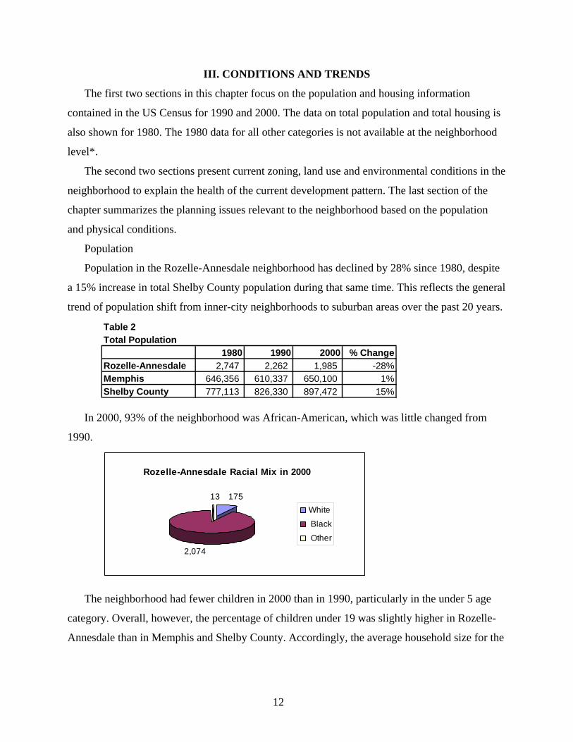
Population in the Rozelle-Annesdale neighborhood has declined by 28% since 1980, despite
a 15% increase in total Shelby County population during that same time. This reflects the general
trend of population shift from inner-city neighborhoods to suburban areas over the past 20 years.
Table 2 Total Population
1980 1990 2000 % ChangeRozelle-Annesdale 2,747 2,262 1,985 -28%Memphis 646,356 610,337 650,100 1%Shelby County 777,113 826,330 897,472 15%
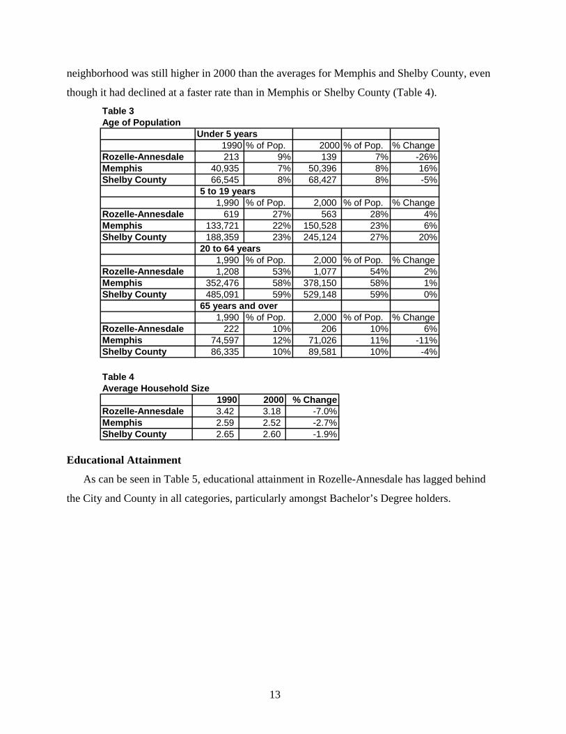
In 2000, 93% of the neighborhood was African-American, which was little changed from
1990.
Rozelle-Annesdale Racial Mix in 2000
175
2,074
13White
Black
Other
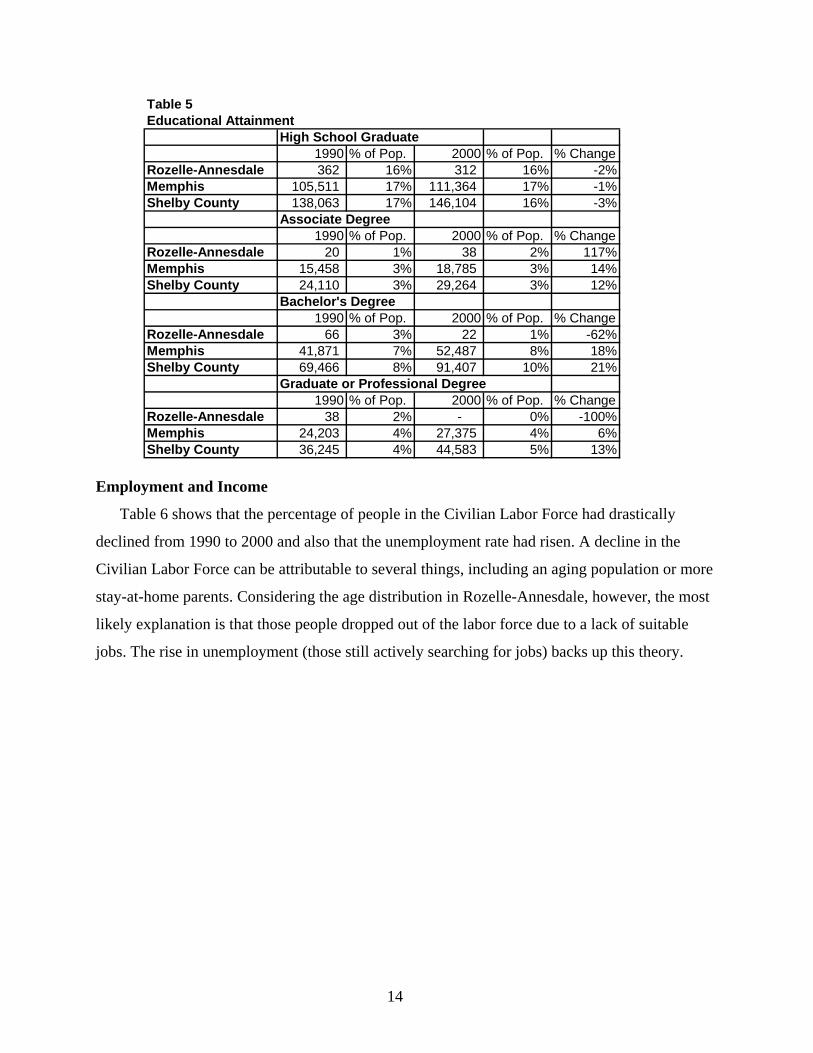
The neighborhood had fewer children in 2000 than in 1990, particularly in the under 5 age
category. Overall, however, the percentage of children under 19 was slightly higher in Rozelle-
Annesdale than in Memphis and Shelby County. Accordingly, the average household size for the
13
neighborhood was still higher in 2000 than the averages for Memphis and Shelby County, even
though it had declined at a faster rate than in Memphis or Shelby County (Table 4). Table 3Age of Population
Under 5 years1990 % of Pop. 2000 % of Pop. % Change
Rozelle-Annesdale 213 9% 139 7% -26%Memphis 40,935 7% 50,396 8% 16%Shelby County 66,545 8% 68,427 8% -5%
5 to 19 years1,990 % of Pop. 2,000 % of Pop. % Change
Rozelle-Annesdale 619 27% 563 28% 4%Memphis 133,721 22% 150,528 23% 6%Shelby County 188,359 23% 245,124 27% 20%
20 to 64 years1,990 % of Pop. 2,000 % of Pop. % Change
Rozelle-Annesdale 1,208 53% 1,077 54% 2%Memphis 352,476 58% 378,150 58% 1%Shelby County 485,091 59% 529,148 59% 0%
65 years and over1,990 % of Pop. 2,000 % of Pop. % Change
Rozelle-Annesdale 222 10% 206 10% 6%Memphis 74,597 12% 71,026 11% -11%Shelby County 86,335 10% 89,581 10% -4%
Table 4Average Household Size
1990 2000 % ChangeRozelle-Annesdale 3.42 3.18 -7.0%Memphis 2.59 2.52 -2.7%Shelby County 2.65 2.60 -1.9%
Educational Attainment
As can be seen in Table 5, educational attainment in Rozelle-Annesdale has lagged behind
the City and County in all categories, particularly amongst Bachelor’s Degree holders.
14
Table 5Educational Attainment
High School Graduate1990 % of Pop. 2000 % of Pop. % Change
Rozelle-Annesdale 362 16% 312 16% -2%Memphis 105,511 17% 111,364 17% -1%Shelby County 138,063 17% 146,104 16% -3%
Associate Degree1990 % of Pop. 2000 % of Pop. % Change
Rozelle-Annesdale 20 1% 38 2% 117%Memphis 15,458 3% 18,785 3% 14%Shelby County 24,110 3% 29,264 3% 12%
Bachelor's Degree1990 % of Pop. 2000 % of Pop. % Change
Rozelle-Annesdale 66 3% 22 1% -62%Memphis 41,871 7% 52,487 8% 18%Shelby County 69,466 8% 91,407 10% 21%
Graduate or Professional Degree1990 % of Pop. 2000 % of Pop. % Change
Rozelle-Annesdale 38 2% - 0% -100%Memphis 24,203 4% 27,375 4% 6%Shelby County 36,245 4% 44,583 5% 13%
Employment and Income
Table 6 shows that the percentage of people in the Civilian Labor Force had drastically
declined from 1990 to 2000 and also that the unemployment rate had risen. A decline in the
Civilian Labor Force can be attributable to several things, including an aging population or more
stay-at-home parents. Considering the age distribution in Rozelle-Annesdale, however, the most
likely explanation is that those people dropped out of the labor force due to a lack of suitable
jobs. The rise in unemployment (those still actively searching for jobs) backs up this theory.
15
Table 6Employment
In Civilian Labor Force1990 % of Pop. 2000 % of Pop. % Change
Rozelle-Annesdale 1,158 51% 711 36% -30%Memphis 292,819 48% 306,442 47% -2%Shelby County 406,434 49% 438,150 49% -1%
Employed1990 % of Pop. 2000 % of Pop. % Change
Rozelle-Annesdale 920 41% 511 26% -37%Memphis 267,179 44% 280,121 43% -2%Shelby County 376,899 46% 408,221 45% 0%
Unemployed 1990 % of Pop. 2000 % of Pop. % Change
Rozelle-Annesdale 138 6% 200 10% 65%Memphis 25,640 4% 26,321 4% -4%Shelby County 29,535 4% 29,929 3% -7%
Not in Labor Force1990 % of Pop. 2000 % of Pop. % Change
Rozelle-Annesdale 635 28% 771 39% 38%Memphis 169,245 28% 180,713 28% 0%Shelby County 207,263 25% 230,888 26% 3%
Table 7 shows that median income levels in the Rozelle-Annesdale neighborhood are lower
than in Memphis and Shelby County. The number of households below poverty level in Rozelle-
Annesdale has increased while the number has declined in both Memphis and Shelby County
when taken as a whole. Table 7Income and Poverty
Median Household Income1990 2000 % Change
Rozelle-Annesdale 15,693 22,656 44.37%Memphis 22,674 32,285 42.39%Shelby County 27,132 39,593 45.93%
Households below Poverty Level1990 % of Pop. 2000 % of Pop. % Change
Rozelle-Annesdale 227 10% 233 12% 17%Memphis 48,140 8% 46,743 7% -9%Shelby County 52,190 6% 50,320 6% -11%
Housing
There were 15% fewer houses in Rozelle-Annesdale in 2000 than in 1980. The percentage of
occupied housing (as opposed to houses standing empty) has remained fairly constant since
1980, but lagging behind Memphis and Shelby County. The percentage of owner-occupied
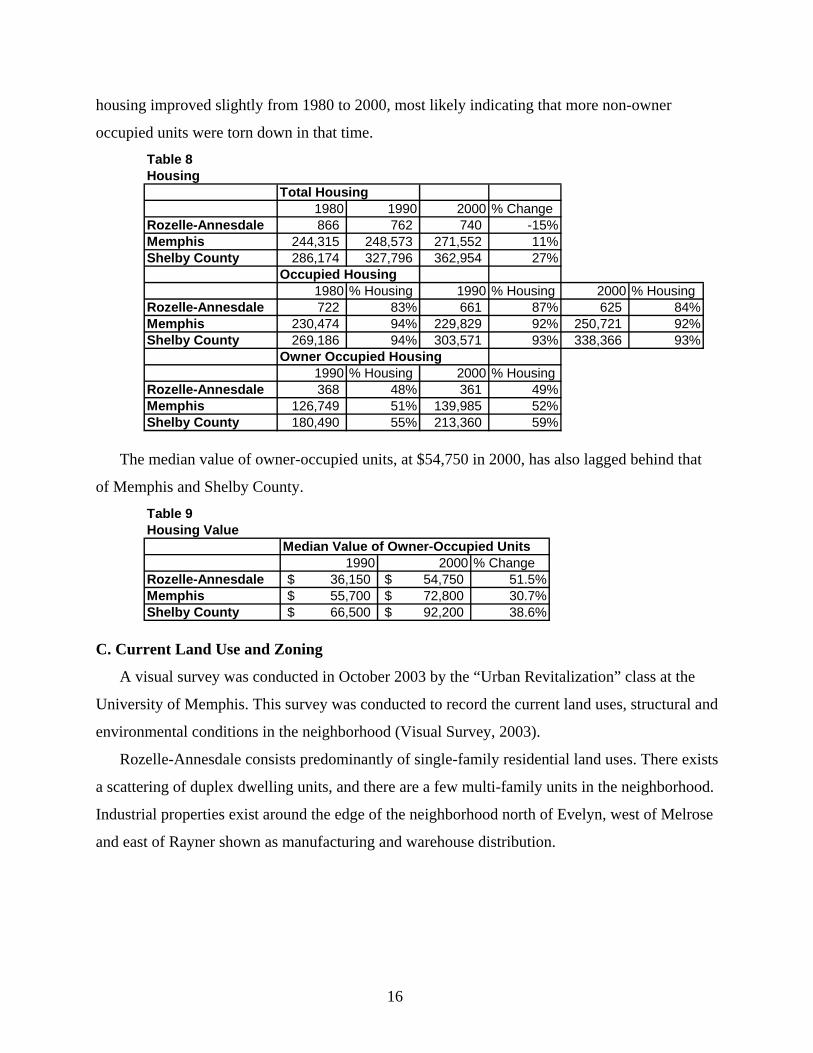
16
housing improved slightly from 1980 to 2000, most likely indicating that more non-owner
occupied units were torn down in that time. Table 8Housing
Total Housing1980 1990 2000 % Change
Rozelle-Annesdale 866 762 740 -15%Memphis 244,315 248,573 271,552 11%Shelby County 286,174 327,796 362,954 27%
Occupied Housing1980 % Housing 1990 % Housing 2000 % Housing
Rozelle-Annesdale 722 83% 661 87% 625 84%Memphis 230,474 94% 229,829 92% 250,721 92%Shelby County 269,186 94% 303,571 93% 338,366 93%
Owner Occupied Housing1990 % Housing 2000 % Housing
Rozelle-Annesdale 368 48% 361 49%Memphis 126,749 51% 139,985 52%Shelby County 180,490 55% 213,360 59%
The median value of owner-occupied units, at $54,750 in 2000, has also lagged behind that
of Memphis and Shelby County. Table 9Housing Value
Median Value of Owner-Occupied Units1990 2000 % Change
Rozelle-Annesdale 36,150$ 54,750$ 51.5%Memphis 55,700$ 72,800$ 30.7%Shelby County 66,500$ 92,200$ 38.6%
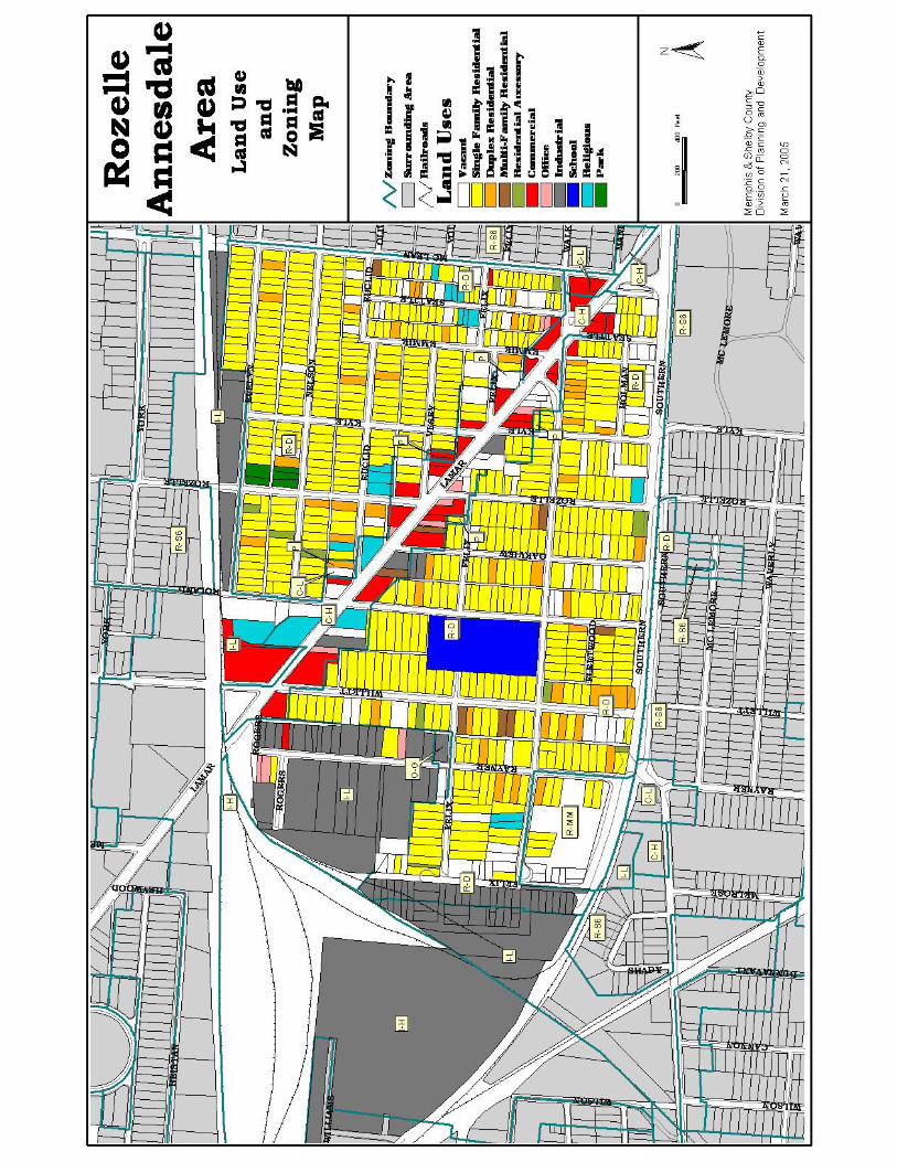
C. Current Land Use and Zoning
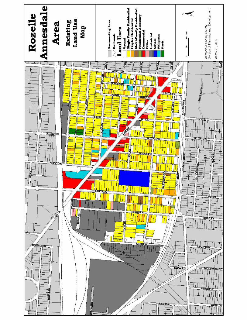
A visual survey was conducted in October 2003 by the “Urban Revitalization” class at the
University of Memphis. This survey was conducted to record the current land uses, structural and
environmental conditions in the neighborhood (Visual Survey, 2003).
Rozelle-Annesdale consists predominantly of single-family residential land uses. There exists
a scattering of duplex dwelling units, and there are a few multi-family units in the neighborhood.
Industrial properties exist around the edge of the neighborhood north of Evelyn, west of Melrose
and east of Rayner shown as manufacturing and warehouse distribution.
18
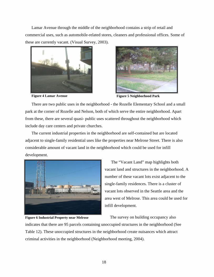
Lamar Avenue through the middle of the neighborhood contains a strip of retail and
commercial uses, such as automobile-related stores, cleaners and professional offices. Some of
these are currently vacant. (Visual Survey, 2003).
There are two public uses in the neighborhood - the Rozelle Elementary School and a small
park at the corner of Rozelle and Nelson, both of which serve the entire neighborhood. Apart
from these, there are several quasi- public uses scattered throughout the neighborhood which
include day care centers and private churches.
The current industrial properties in the neighborhood are self-contained but are located
adjacent to single-family residential uses like the properties near Melrose Street. There is also
considerable amount of vacant land in the neighborhood which could be used for infill
development.
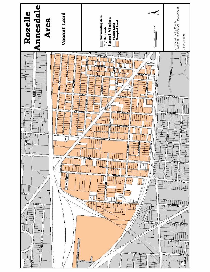
The “Vacant Land” map highlights both
vacant land and structures in the neighborhood. A
number of these vacant lots exist adjacent to the
single-family residences. There is a cluster of
vacant lots observed in the Seattle area and the
area west of Melrose. This area could be used for
infill development.
The survey on building occupancy also
indicates that there are 95 parcels containing unoccupied structures in the neighborhood (See
Table 12). These unoccupied structures in the neighborhood create nuisances which attract
criminal activities in the neighborhood (Neighborhood meeting, 2004).
Figure 4 Lamar Avenue Figure 5 Neighborhood Park
Figure 6 Industrial Property near Melrose
19
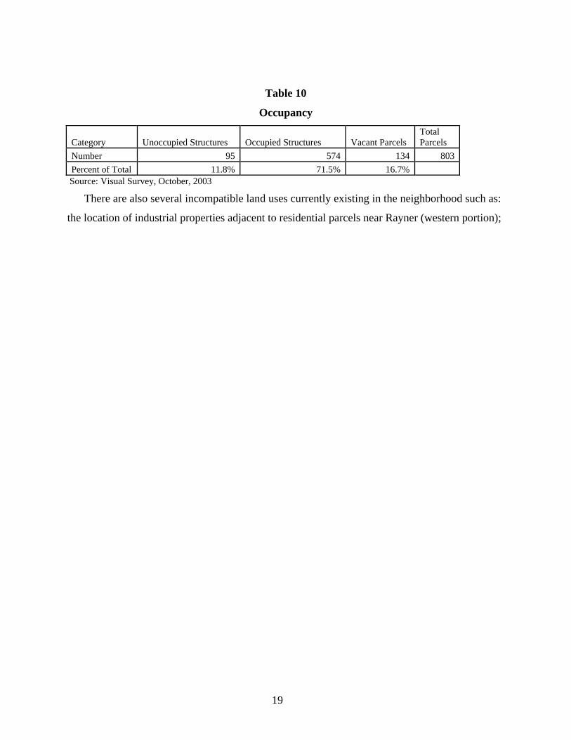
Table 10
Occupancy
Category Unoccupied Structures Occupied Structures Vacant Parcels Total Parcels
Number 95 574 134 803 Percent of Total 11.8% 71.5% 16.7%
Source: Visual Survey, October, 2003
There are also several incompatible land uses currently existing in the neighborhood such as:
the location of industrial properties adjacent to residential parcels near Rayner (western portion);
21
the encroachment of commercial properties into the residential area along Lamar Avenue; and
the strip of industrial properties north of Evelyn, facing the residential properties.
Most of the neighborhood is zoned Duplex Residential District (R-D) and all of the existing
industrial uses are zoned as Light Industrial (I-L). Lamar Avenue, a commercial corridor in the
neighborhood, is currently zoned as Highway Commercial (H-C). Some other zoning categories
such as Parking (P) and Local Commercial (C-L) also exist on either side of Lamar (adjacent to
the H-C zoning). Though the General Office (O-G) zoning category exists, land in this zone is
currently vacant.
There are several problems with the current zoning in the neighborhood as indicated below:
• Lamar Avenue is zoned as highway commercial which allows for warehouse
(wholesale) facilities and used car lots, which are out of character with the retail uses
and have further negative impacts on the residential areas.
• The commercial zoning along Lamar Avenue extends into the residential use areas
and invites further deterioration of housing.
• The land zoned as duplex (R-D) is actually used for single-family residences, and the
division of these units into duplex residential could increase the number of renter-
occupied units and further erode homeownership.
• The location of light industrial uses adjacent to the residential zoning is also of
concern to the neighborhood residents because of its incompatibility with the
residential character of the neighborhood (Neighborhood meeting, 2004).
D. Structural and Environmental Conditions
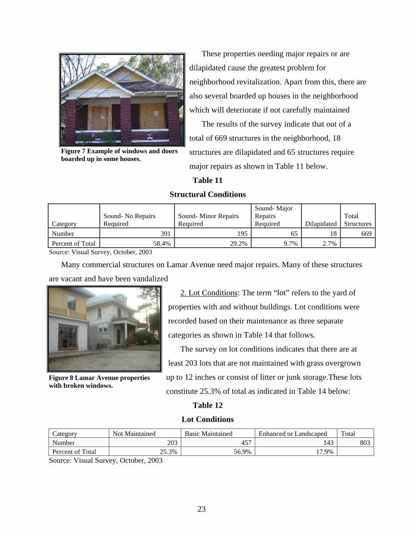
The visual survey conducted by the Urban Revitalization class produced data about structural
and lot conditions which are discussed as follows:
1. Structural Condition: Structures were coded as being in “sound condition”, “needing minor
repairs”, “needing major repairs” and “dilapidated”. Examples of buildings needing minor
repairs are those that need exterior painting or have slight cracks in the eaves. Examples of
buildings requiring major repairs are the ones that need roofs fixed or have foundations
damaged. Structures in dilapidated condition require costly repairs, which are not feasible. A
cluster of dilapidated houses can be found in the Seattle area and to the east of Melrose Street.
23
These properties needing major repairs or are
dilapidated cause the greatest problem for
neighborhood revitalization. Apart from this, there are
also several boarded up houses in the neighborhood
which will deteriorate if not carefully maintained
The results of the survey indicate that out of a
total of 669 structures in the neighborhood, 18
structures are dilapidated and 65 structures require
major repairs as shown in Table 11 below.
Table 11
Structural Conditions
Category Sound- No Repairs Required
Sound- Minor Repairs Required
Sound- Major Repairs Required Dilapidated
Total Structures
Number 391 195 65 18 669Percent of Total 58.4% 29.2% 9.7% 2.7%
Source: Visual Survey, October, 2003
Many commercial structures on Lamar Avenue need major repairs. Many of these structures
are vacant and have been vandalized
2. Lot Conditions: The term “lot” refers to the yard of
properties with and without buildings. Lot conditions were
recorded based on their maintenance as three separate
categories as shown in Table 14 that follows.
The survey on lot conditions indicates that there are at
least 203 lots that are not maintained with grass overgrown
up to 12 inches or consist of litter or junk storage.These lots
constitute 25.3% of total as indicated in Table 14 below:
Table 12
Lot Conditions
Category Not Maintained Basic Maintained Enhanced or Landscaped Total Number 203 457 143 803 Percent of Total 25.3% 56.9% 17.9%
Source: Visual Survey, October, 2003
Figure 7 Example of windows and doors boarded up in some houses.
Figure 8 Lamar Avenue properties with broken windows.
25
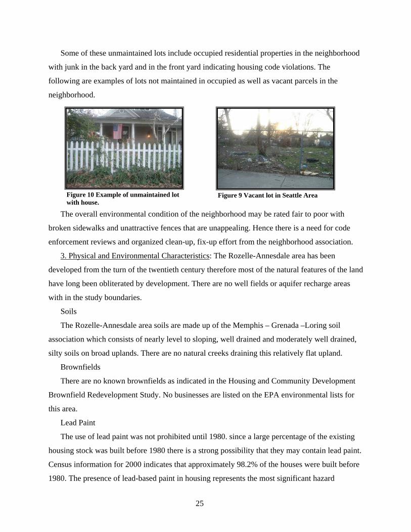
Some of these unmaintained lots include occupied residential properties in the neighborhood
with junk in the back yard and in the front yard indicating housing code violations. The
following are examples of lots not maintained in occupied as well as vacant parcels in the
neighborhood.
The overall environmental condition of the neighborhood may be rated fair to poor with
broken sidewalks and unattractive fences that are unappealing. Hence there is a need for code
enforcement reviews and organized clean-up, fix-up effort from the neighborhood association.
3. Physical and Environmental Characteristics: The Rozelle-Annesdale area has been
developed from the turn of the twentieth century therefore most of the natural features of the land
have long been obliterated by development. There are no well fields or aquifer recharge areas
with in the study boundaries.
Soils
The Rozelle-Annesdale area soils are made up of the Memphis – Grenada –Loring soil
association which consists of nearly level to sloping, well drained and moderately well drained,
silty soils on broad uplands. There are no natural creeks draining this relatively flat upland.
Brownfields
There are no known brownfields as indicated in the Housing and Community Development
Brownfield Redevelopment Study. No businesses are listed on the EPA environmental lists for
this area.
Lead Paint
The use of lead paint was not prohibited until 1980. since a large percentage of the existing
housing stock was built before 1980 there is a strong possibility that they may contain lead paint.
Census information for 2000 indicates that approximately 98.2% of the houses were built before
1980. The presence of lead-based paint in housing represents the most significant hazard
Figure 10 Example of unmaintained lot with house.
Figure 9 Vacant lot in Seattle Area
26
remaining for lead poisoning, particularly for young children. Families with young children who
live in homes built before 1980 should have their children tested for lead poisoning. A lead
abatement program is available to homeowners of low to moderate income who have young
children that have tested for lead. This abatement program is offered through the Lead Paint
Program at the City of Memphis Division of Housing and Community Development.
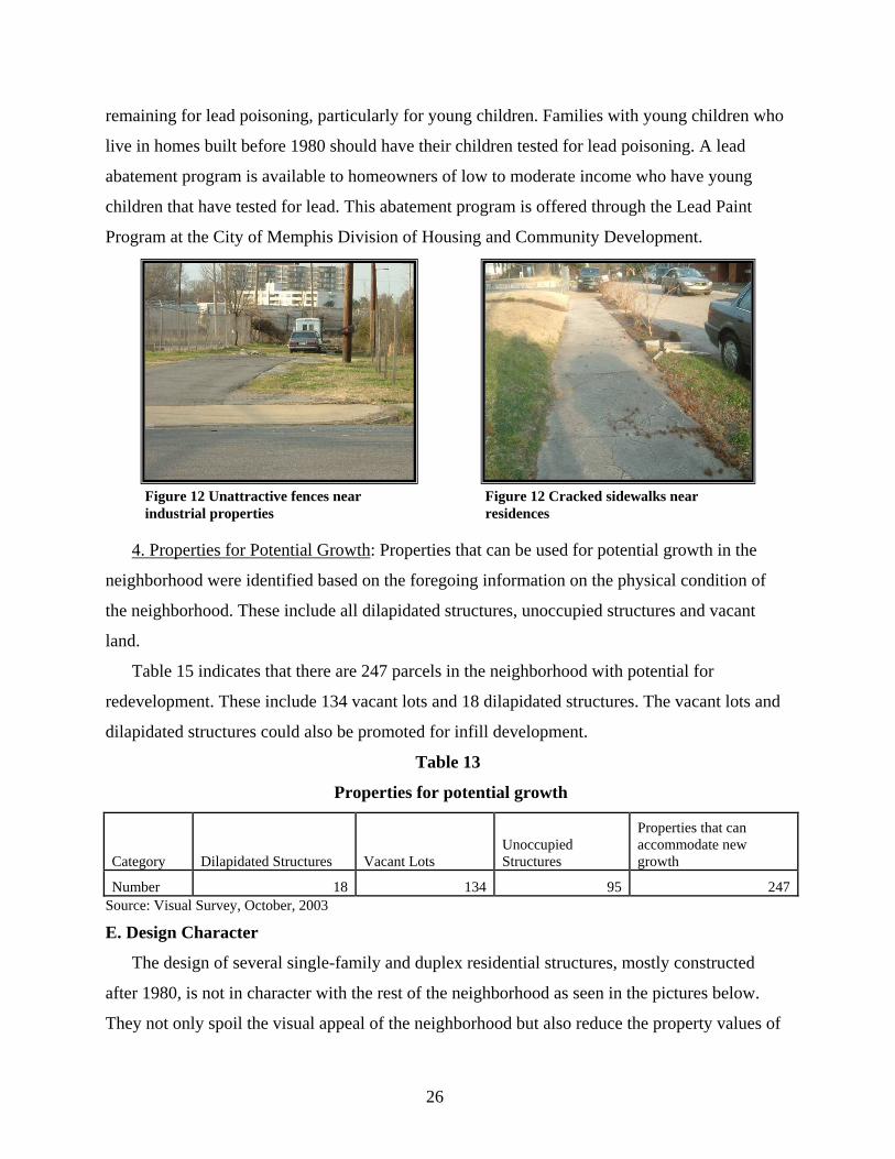
4. Properties for Potential Growth: Properties that can be used for potential growth in the
neighborhood were identified based on the foregoing information on the physical condition of
the neighborhood. These include all dilapidated structures, unoccupied structures and vacant
land.
Table 15 indicates that there are 247 parcels in the neighborhood with potential for
redevelopment. These include 134 vacant lots and 18 dilapidated structures. The vacant lots and
dilapidated structures could also be promoted for infill development.
Table 13
Properties for potential growth
Category Dilapidated Structures Vacant Lots Unoccupied Structures
Properties that can accommodate new growth
Number 18 134 95 247Source: Visual Survey, October, 2003
E. Design Character
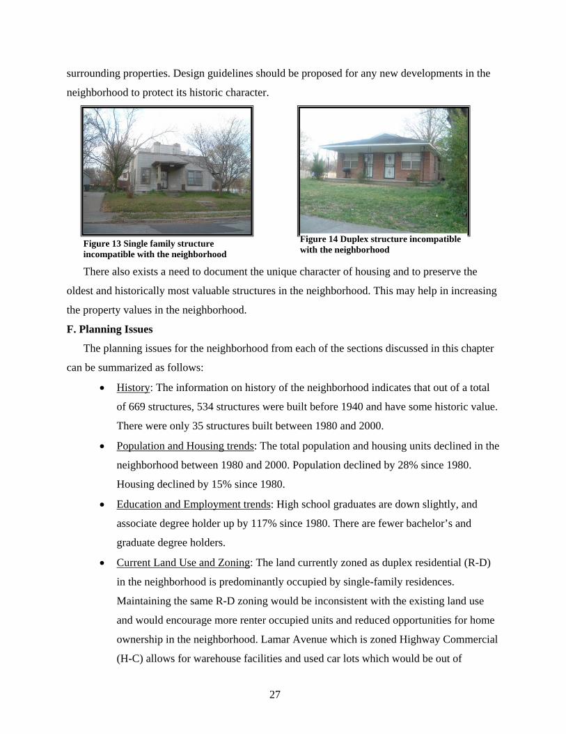
The design of several single-family and duplex residential structures, mostly constructed
after 1980, is not in character with the rest of the neighborhood as seen in the pictures below.
They not only spoil the visual appeal of the neighborhood but also reduce the property values of
Figure 12 Unattractive fences near industrial properties
Figure 12 Cracked sidewalks near residences
27
surrounding properties. Design guidelines should be proposed for any new developments in the
neighborhood to protect its historic character.
There also exists a need to document the unique character of housing and to preserve the
oldest and historically most valuable structures in the neighborhood. This may help in increasing
the property values in the neighborhood.
F. Planning Issues
The planning issues for the neighborhood from each of the sections discussed in this chapter
can be summarized as follows:
• History: The information on history of the neighborhood indicates that out of a total
of 669 structures, 534 structures were built before 1940 and have some historic value.
There were only 35 structures built between 1980 and 2000.
• Population and Housing trends: The total population and housing units declined in the
neighborhood between 1980 and 2000. Population declined by 28% since 1980.
Housing declined by 15% since 1980.
• Education and Employment trends: High school graduates are down slightly, and
associate degree holder up by 117% since 1980. There are fewer bachelor’s and
graduate degree holders.
• Current Land Use and Zoning: The land currently zoned as duplex residential (R-D)
in the neighborhood is predominantly occupied by single-family residences.
Maintaining the same R-D zoning would be inconsistent with the existing land use
and would encourage more renter occupied units and reduced opportunities for home
ownership in the neighborhood. Lamar Avenue which is zoned Highway Commercial
(H-C) allows for warehouse facilities and used car lots which would be out of
Figure 13 Single family structure incompatible with the neighborhood
Figure 14 Duplex structure incompatible with the neighborhood
28
character with the surrounding retail uses. C-H zoning also extends into residential
areas. Vacant lots offer an opportunity for infill development. (There is a perception
by residents that a greater incidence of crime occurs in areas with vacant properties.)
• Structural and Environmental Conditions: The visual survey results indicate that there
are around 18 dilapidated structures and 65 structures needing major repairs in the
neighborhood. These structures spoil the visual appeal of the neighborhood and can
also cause decline in surrounding property values. The dilapidated structures may
need to be demolished if they require costly repairs which are not economically
feasible. There are around 203 unmaintained lots in the neighborhood with grass
overgrown up to 12 inches in height and littered with junk storage. The residents of
these properties should be encouraged to clean up their lots in order to improve the
aesthetic appeal of the neighborhood.
• Properties for Potential Growth: There are 247 parcels which are vacant, have
unoccupied structures or dilapidated structures in the neighborhood. These parcels
could be used for accommodating growth in the neighborhood.
• Design Character: The design character of some of the new residential structures
constructed after 1980 is incompatible with the existing residential character of the
neighborhood. Design guidelines should be proposed for any new developments that
take place in the neighborhood. The historic value of the neighborhood should be
preserved to maintain its unique character. This could also increase the house values
as well as promote redevelopment of houses.
29
IV. PLAN CONCEPT
This chapter presents a development concept for the overall improvement of the
neighborhood based on the planning issues discussed in the previous chapter. The goals for
development are first outlined, a schematic design for the development of the entire
neighborhood is proposed based on the goals. It is intended that desired development in the
neighborhood will be achieved by 2010.
A. Development Plan Goals for 2010
Goal 1: Encourage the current mix of land uses to continue in the
neighborhood.
Goal 2: Limit the future expansion of commercial and industrial uses to
prevent their encroachment into residential areas while encouraging development
of more compatible uses.
Goal 3: Provide an effective road network to ensure safety of the
neighborhood.
Goal 4: Encourage commercial area enhancement to eliminate vacant
commercial properties and promote neighborhood related commercial uses in this
area.
Goal 5: Improve the physical condition of the neighborhood and promote
infill development to encourage population growth and home ownership.
Goal 6: Provide affordable housing opportunities to increase homeownership
and occupancy in the neighborhood.
Goal 7: Provide a sense of ownership and belonging to the residents to protect
the residential character of the neighborhood.
B. Plan Proposals
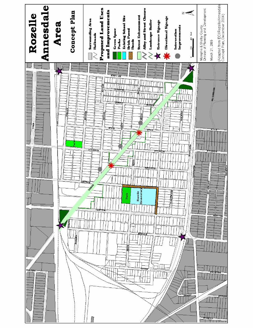
Based on these goals, a general plan concept for revitalizing the neighborhood is presented in
this section. Specific issues related to the plan are also addressed.
1. Road Network: The traditional grid pattern of streets exists in the neighborhood in the
sections north and south of Lamar Avenue, which passes radially through the middle of
the neighborhood. Several street re-alignments and closures were made in the 1980’s
and early 1990’s to prevent intrusion of industrial traffic into the residential area. This
30
included the closing of Felix and Walker at Melrose in the western end of the
neighborhood.
2. It is recommended that a study be conducted by the City Engineer of several street
segments to determine if improvements should be made to mitigate dangerous
conditions at intersections and to provide for smoother flow of traffic. Included in the
study should be recommendations for possible street closures. At a minimum the
following segments should be studied: Felix, Vesey, and Euclid where they each
intersect with Lamar.
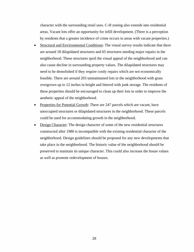
Brick paving should be provided at some
street crossings to give priority to the
pedestrians over the vehicular traffic. Since
there are many school children attending
Rozelle School presently from within and
outside the neighborhood, this would help to
calm traffic at these junctions near the school
and thus prevent accidents. If Lamar is chosen
as a light rail corridor, there may be an
opportunity to link crosswalk improvements with the rail construction.
The alleys in Seattle area are no longer utilized by residents nor by the City. A survey of
residents taken in 2001 by the Pigeon Roost Development Corporation showed unanimous
support for closure of the alleys, and a meeting of residents at that time confirmed the support for
closure. However, the alleys are part of the historic pattern of the neighborhood.
2. Commercial Development: Lamar Avenue, which historically served as a meeting location
for the residents, currently consists of many vacant, dilapidated structures and a visually poor
streetscape. Hence there is a need to enhance the visual appeal of this area to promote
commercial development. This could be accomplished by the Pigeon Roost Development
Corporation acquiring several vacant pieces of property at the entries into the neighborhood at
Lamar and McLean, at Lamar and Willett, and a privately owned parcel at Vesey and Lamar,
none of which are suitable for development. Landscaping and signage could be provided at each
location identifying the Rozelle-Annesdale neighborhood.
Figure 15 Example of brick paved crossing
31
Sidewalk enhancement is recommended along Lamar to create an aesthetic appeal and to
provide safer access for residents who visit the commercial properties. Brick-paved pedestrian
crossings may also be provided at intersections of Lamar Avenue and all other streets which pass
through the neighborhood in order to slow down the traffic entering the residential area.
Landscape buffers should surround the commercial properties to protect the privacy of
residential area. Signage should identify location of key businesses and at the neighborhood
entrances as indicated below. Green spaces may be provided at key locations and around the
commercial nodes to enhance the visual appearance of Lamar Avenue.
Lamar Avenue street enhancement techniques are discussed in detail in the following
subsections:
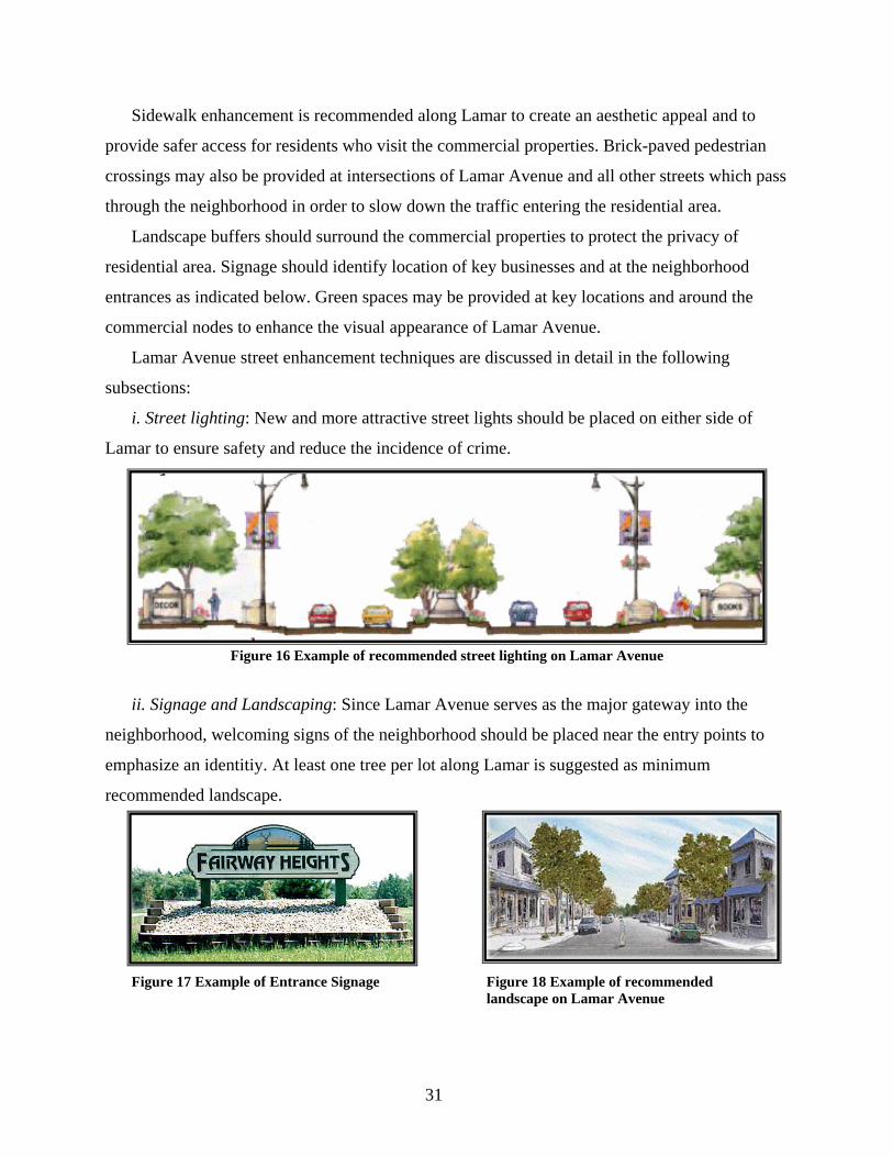
i. Street lighting: New and more attractive street lights should be placed on either side of
Lamar to ensure safety and reduce the incidence of crime.
ii. Signage and Landscaping: Since Lamar Avenue serves as the major gateway into the
neighborhood, welcoming signs of the neighborhood should be placed near the entry points to
emphasize an identitiy. At least one tree per lot along Lamar is suggested as minimum
recommended landscape.
Figure 16 Example of recommended street lighting on Lamar Avenue
Figure 17 Example of Entrance Signage
Figure 18 Example of recommended landscape on Lamar Avenue
32
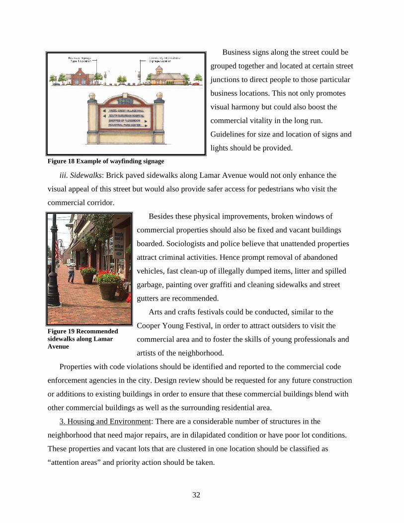
Business signs along the street could be
grouped together and located at certain street
junctions to direct people to those particular
business locations. This not only promotes
visual harmony but could also boost the
commercial vitality in the long run.
Guidelines for size and location of signs and
lights should be provided.
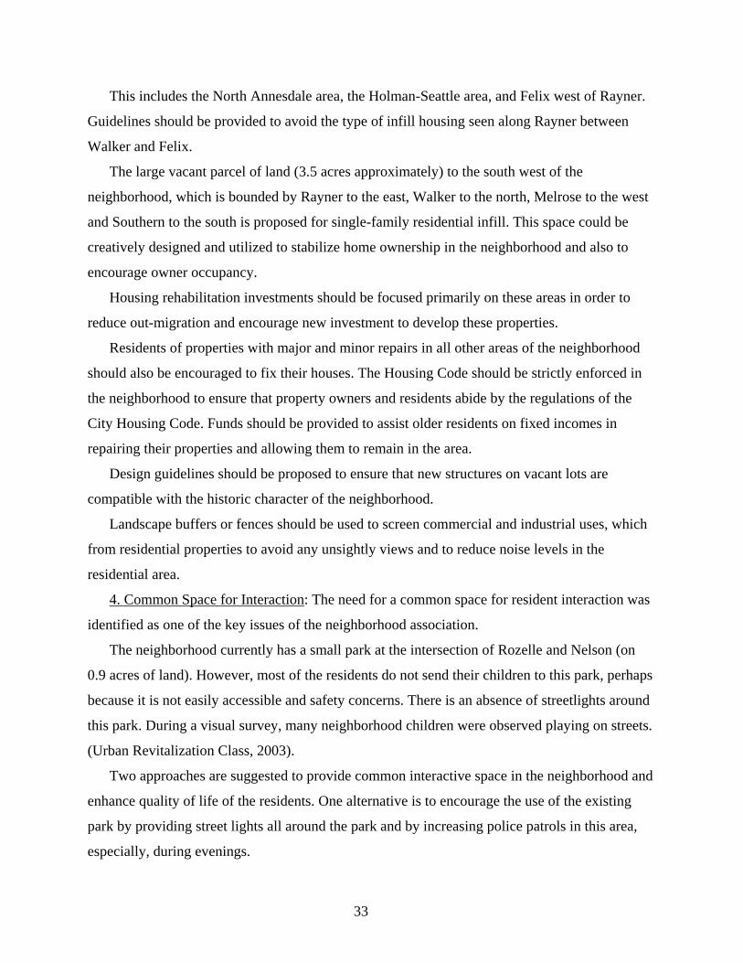
iii. Sidewalks: Brick paved sidewalks along Lamar Avenue would not only enhance the
visual appeal of this street but would also provide safer access for pedestrians who visit the
commercial corridor.
Besides these physical improvements, broken windows of
commercial properties should also be fixed and vacant buildings
boarded. Sociologists and police believe that unattended properties
attract criminal activities. Hence prompt removal of abandoned
vehicles, fast clean-up of illegally dumped items, litter and spilled
garbage, painting over graffiti and cleaning sidewalks and street
gutters are recommended.
Arts and crafts festivals could be conducted, similar to the
Cooper Young Festival, in order to attract outsiders to visit the
commercial area and to foster the skills of young professionals and
artists of the neighborhood.
Properties with code violations should be identified and reported to the commercial code
enforcement agencies in the city. Design review should be requested for any future construction
or additions to existing buildings in order to ensure that these commercial buildings blend with
other commercial buildings as well as the surrounding residential area.
3. Housing and Environment: There are a considerable number of structures in the
neighborhood that need major repairs, are in dilapidated condition or have poor lot conditions.
These properties and vacant lots that are clustered in one location should be classified as
“attention areas” and priority action should be taken.
Figure 18 Example of wayfinding signage
Figure 19 Recommended sidewalks along Lamar Avenue
33
This includes the North Annesdale area, the Holman-Seattle area, and Felix west of Rayner.
Guidelines should be provided to avoid the type of infill housing seen along Rayner between
Walker and Felix.
The large vacant parcel of land (3.5 acres approximately) to the south west of the
neighborhood, which is bounded by Rayner to the east, Walker to the north, Melrose to the west
and Southern to the south is proposed for single-family residential infill. This space could be
creatively designed and utilized to stabilize home ownership in the neighborhood and also to
encourage owner occupancy.
Housing rehabilitation investments should be focused primarily on these areas in order to
reduce out-migration and encourage new investment to develop these properties.
Residents of properties with major and minor repairs in all other areas of the neighborhood
should also be encouraged to fix their houses. The Housing Code should be strictly enforced in
the neighborhood to ensure that property owners and residents abide by the regulations of the
City Housing Code. Funds should be provided to assist older residents on fixed incomes in
repairing their properties and allowing them to remain in the area.
Design guidelines should be proposed to ensure that new structures on vacant lots are
compatible with the historic character of the neighborhood.
Landscape buffers or fences should be used to screen commercial and industrial uses, which
from residential properties to avoid any unsightly views and to reduce noise levels in the
residential area.
4. Common Space for Interaction: The need for a common space for resident interaction was
identified as one of the key issues of the neighborhood association.
The neighborhood currently has a small park at the intersection of Rozelle and Nelson (on
0.9 acres of land). However, most of the residents do not send their children to this park, perhaps
because it is not easily accessible and safety concerns. There is an absence of streetlights around
this park. During a visual survey, many neighborhood children were observed playing on streets.
(Urban Revitalization Class, 2003).
Two approaches are suggested to provide common interactive space in the neighborhood and
enhance quality of life of the residents. One alternative is to encourage the use of the existing
park by providing street lights all around the park and by increasing police patrols in this area,
especially, during evenings.
34
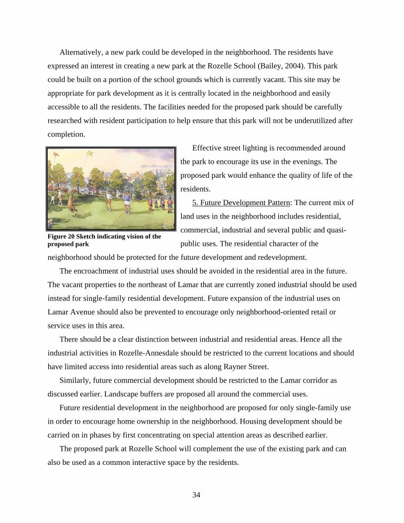
Alternatively, a new park could be developed in the neighborhood. The residents have
expressed an interest in creating a new park at the Rozelle School (Bailey, 2004). This park
could be built on a portion of the school grounds which is currently vacant. This site may be
appropriate for park development as it is centrally located in the neighborhood and easily
accessible to all the residents. The facilities needed for the proposed park should be carefully
researched with resident participation to help ensure that this park will not be underutilized after
completion.
Effective street lighting is recommended around
the park to encourage its use in the evenings. The
proposed park would enhance the quality of life of the
residents.
5. Future Development Pattern: The current mix of
land uses in the neighborhood includes residential,
commercial, industrial and several public and quasi-
public uses. The residential character of the
neighborhood should be protected for the future development and redevelopment.
The encroachment of industrial uses should be avoided in the residential area in the future.
The vacant properties to the northeast of Lamar that are currently zoned industrial should be used
instead for single-family residential development. Future expansion of the industrial uses on
Lamar Avenue should also be prevented to encourage only neighborhood-oriented retail or
service uses in this area.
There should be a clear distinction between industrial and residential areas. Hence all the
industrial activities in Rozelle-Annesdale should be restricted to the current locations and should
have limited access into residential areas such as along Rayner Street.
Similarly, future commercial development should be restricted to the Lamar corridor as
discussed earlier. Landscape buffers are proposed all around the commercial uses.
Future residential development in the neighborhood are proposed for only single-family use
in order to encourage home ownership in the neighborhood. Housing development should be
carried on in phases by first concentrating on special attention areas as described earlier.
The proposed park at Rozelle School will complement the use of the existing park and can
also be used as a common interactive space by the residents.
Figure 20 Sketch indicating vision of the proposed park
36
V. ORGANIZATION FOR ACTION
Every action in this plan requires specific implementation. This chapter presents steps to be
taken by the residents, neighborhood organizations and city agencies for this plan’s
implementation. The chapter concludes by giving an overview of the neighborhood’s assets
which will help to attract population into the neighborhood after the proposed developments are
made.
The strategic steps for implementation cover the following: neighborhood organization,
commercial area development, public facility investment, housing development and land use
regulation.
A. Neighborhood Organization
The Rozelle-Annesdale neighborhood currently has two functioning organizations as
mentioned earlier in this report. They are the Rozelle-Annesdale Neighborhood Association and
the Pigeon Roost Development Corporation. Each organization serves a special purpose in the
future growth and development of the neighborhood. The neighborhood association is focused
on the social organization of the area residents while the development corporation is best suited
to deal with technical matters such as planning, housing, and infrastructure. Each needs the other,
and they work closely together.
1.Rozelle-Annesdale Neighborhood Association (RAAA):
The Rozelle-Annesdale Area Association was originally organized in 1973 by local residents
to address many of the same type problems they face today. The residents developed a
comprehensive plan and, after submitting it to HCD, was awarded a Block Grant to address
many of those needs The association was reorganized recently in order to more efficiently
address the problems of crime, drugs, and gangs in the area. The President and other officers
meet monthly with the commander of the Memphis police west precinct to identify trouble spots
and to address these issues. They have been able to eliminate most of the drug traffic along
Seattle Street by working with the Vice/Narcotics squad and the west precinct to arrest dealers
and with Housing and Community Development to demolish many of the crack houses. It will be
necessary to continue this close cooperation in the future and to develop a more persistent focus
on the remaining drug dealers in the entire area. The President and other officers meet regularly
with the code enforcement officials of the city and county to point out code violations and
trouble spots in the area. The relationship has been productive, but a more rigorous and sustained
37
effort will be necessary to bring much of the area into compliance with the codes. The
association must provide programs to educate the residents about the codes and ways to help
enforce them.
The association must find ways to involve more of the residents in the activities of the
association and to encourage a sense of belonging and togetherness throughout the
neighborhood.
2. Pigeon Roost Development Corporation (PRDC): The Pigeon Roost Development
Corporation was formed in 1985 to address the problems of decline in both the residential and
commercial areas of the neighborhood. After achieving its primary goals, the corporation was
shut down in 1990. The charter was renewed in 2001, and the Corporation is currently working
closely with the neighborhood association and local residents to eliminate the drug dealers in the
North Annesdale area and assisted in the develop of this comprehensive plan for the
neighborhood. It will be necessary for the corporation to seek and obtain funding for staff and
operating expenses in order to implement the recommendations in the plan.
B. Commercial Area Development
The Pigeon Roost Development Corporation should take the lead and work with the
Memphis City Beautiful Commission and Housing and Community Development in order to
implement the ideas for enhancing Lamar Avenue presented in this report.
1. Capital Projects: Several capital projects are recommended in this plan for commercial
area development such as fixing sidewalks, introduction of new signage and provision for
adequate street lighting.
These projects should be prioritized by the development corporation based on need and
should be presented to the legislative authorities to gain funding.
2. Private Business Developments: Repair, façade improvement and demolition of
dilapidated structures are some of the private business developments recommended in this plan.
The Memphis Business Development Center (MBDC) provides technical assistance to help
private institutions and organizations to grow successful businesses. Although the MBDC does
not provide funds directly, it assists private business owners to obtain loans from banks and other
financial institutions.
3. Funding: Programs such as the Micro Loan Program and Section 108 Loan Program can
be used by private business owners to develop new businesses along Lamar Avenue. The Micro
38
Loan Program is offered to business owners who have eligible licensed businesses and who
operate within the City of Memphis. The loan amount ranges from a minimum of $5,000 to a
maximum of $10,000.
The Section 108 Loan Program offers assistance to entitled cities to receive funds from the
US Department of Housing and Urban Development (HUD). HUD allows these entitled cities to
transform a small portion of their Community Development Block Grant (CDBG) funds into
federally guaranteed loans which can be used for private investments in an area or project.
However, these projects must meet the national objectives of CDBG and must benefit low- or
middle-income persons.
4. Business Association: The existing business and property owners should be encouraged to
form a “business association” in order to protect their interests. This association should notify the
business owners of vacant and dilapidated properties on Lamar and encourage them to either fix
or sell their properties, so as to avoid unattended vacant structures along this street. However, in
the absence of a business association, this job may be handled by the Pigeon Roost Development
Corporation.
Business festivals could be organized in the long run, by the business association and the
neighborhood association, to exhibit the skills of craftsmen in the neighborhood. This could
serve as a good marketing strategy to attract outsiders to visit the Rozelle-Annesdale business
area.
A “business watch program” could be organized by the business association in partnership
with the Memphis police to encourage creative ideas aimed at reducing crime in the business
area. The business owners and their employees may form a network of communication with the
police department and inform them about the various criminal activities that are prevalent in the
business area. Additional research and alternative methods should be explored to reduce the
incidence of crime, which is not included in the scope of this study.
C. Public Facility Investment
The public facilities proposed in this plan can be listed as follows:
Construction of new park near Rozelle School
Provision of street lights for existing park
Repair of sidewalks in residential and commercial areas
Provision of landscape buffers
39
Provision of entrance and way finding signage in commercial area
Provision of adequate street lights in both residential and commercial areas and
Provision of brick paving at certain street crossings.
1. Funding from City: The basis for public facility funding by the City of Memphis is the
Capital Improvements Program (CIP), which is a six-year schedule of projects and is updated
every year. The Pigeon Roost Development Corporation and Rozelle-Annesdale Neighborhood
Association should therefore provide a list of proposed projects in the neighborhood with
necessary documentation to the City of Memphis in order to gain necessary funding.
After the funds are obtained, the projects may be prioritized for immediate action by these
organizations. These projects may be carried on in several phases, based on the amount of funds
available.
2. Funds from Other Organizations: Alternative sources of funding may also be explored by
these organizations to gain the funds required. For example, for commercial area enhancement,
funding could be sought from the Local Initiative Supporter’s Corporation (LISC), which has
helped neighborhood groups in many states such as Florida, Ohio, Missouri, and Illinois to fund
their commercial area revitalization (CPS, 2003). This provides funds for public facility
improvements such as façade and sidewalk improvement.
D. Housing Development
The housing development program should have five components. These include gathering
necessary funds to carry on the projects, dealing with problems of code violations, encouraging
infill development, creating historic conservation overlay and eliminating the problem of
boarding houses in the neighborhood. These are discussed in the following subsections.
1. Funding: This plan identified 152 parcels in the neighborhood as properties for new infill
development. There are also 65 properties needing major repairs. Therefore funding is essential
to implement new housing development in the neighborhood and also to offer assistance to
existing low income households to fix their properties.
The Memphis Division of Housing and Community Development (HCD) offers programs for
neighborhoods needing housing revitalization and requiring new affordable housing (OPD,
2003).
40
HCD receives federal funds from the Community Development Block Grant Program
(CDBG), HOME Program, Emergency Shelter Grant Program (ESG), Housing Opportunities for
Persons with Aids (HOPWA) and the Youth Build and Supportive Housing Programs.
The State of Tennessee provides funds from Tennessee Housing Development Agency
(THDA). THDA’s Homeownership Program provides financial assistance to low- and moderate-
income people to obtain sound and affordable housing. It helps obtain loans for purchasing a
home by a first-time home buyer based on an attractive interest rate. The first-time homebuyer
must not exceed certain income limits in order to use this program.
The City of Memphis also offers several programs for housing development such as Down
Payment Assistance (DPA), Housing Rehabilitation (HARP), Minor Home Repair, Volunteer
Home Repair, Single and Multifamily Development, Building for the Future and funding for
Community Housing Development Organizations (CHDOs). The Down Payment Assistance
Program (DPA), Housing and Rehabilitation Program (HARP) and funding for CHDOs are most
applicable and beneficial to Rozelle-Annesdale neighborhood.
The DPA provides grants or loans to low- and very low-income first time home buyers. In
order to use this program, applicants must meet the low- and very low-income limits as defined
by HUD. The HARP provides financial and construction assistance to low- and moderate-
income homeowners to repair their houses. Repairs include roofing, electrical, plumbing,
painting and interior finish work. The funding limit varies depending on the number of people in
the household, the household income and the amount of work needed to repair the house.
The neighborhood association may also apply for inclusion in the SMART Neighborhood
Revitalization Strategy started by HCD and the mayor to target redevelopment of neighborhoods.
Other grant opportunities may also be sought for Rozelle-Annesdale, such as the neighborhood
demonstration gGrants.
The Pigeon Roost Development Corporation should meet with the staff of HCD to establish
funding potential for programs to secure direct funding or to help prospective homeowners
obtain necessary financing.
2.Code violations: Residents may file complaints against properties that violate housing
codes to the housing and code enforcement agency of the city. The housing code enforcement
agency ensures proper maintenance of housing in the city through the housing anti neglect code
41
According to this code, if the owner of the property, after being repeatedly notified, neglects
the orders of the code enforcement agency, the manager of the housing and code enforcement
agency is obligated to take action against the owners of the house.
The neighborhood association’s verbal discussions with owners of problem properties may
sometimes serve as best way to deal with this problem. The neighborhood association can work
with its area leaders, block captains and police officers in code enforcement and may accordingly
request police to enforce housing code in the neighborhood and thus assist the city housing code
enforcement agency.
3. Infill development: The Pigeon Roost Development Corporation should do title searches
of properties at the County Registrar’s Office where infill is proposed, to identify the existing
owners of these sites and acquire these lots accordingly. The PRDC should also coordinate with
HCD to provide affordable housing opportunities to low-income households in order to develop
these infill sites (as discussed in funding section above).
4. Historic conservation: The neighborhood association should work with Memphis Heritage
Inc. and the Landmarks Commission staff to create documentation about various housing styles
and location of historic properties in the neighborhood. An application should be submitted to
the Memphis Landmarks Commission for Historic Conservation (H-C) Overlay District
approval.
5. Boarding houses: The neighborhood association should encourage the neighbors of
boarding houses, where there is evidence of criminal activities, to inform them about their
existence through a phone call or through mail-back surveys. The association should then take
action against such type of activities in these houses by coordinating with the city police
department.
E. Land use regulations
The regulation of land use in the neighborhood is accomplished through the Memphis and
Shelby County zoning ordinance. The planning staff of Division of Planning and Development
(DPD) reviews the requests for rezoning and presents a staff report on the recommended
rezoning to the Land Use Control Board. This board conducts a public hearing of the case and
recommends its decision to the Memphis City Council.
The Memphis City Council makes the final judgment. Hence in order to reduce the land use
and zoning conflicts in the neighborhood and implement this plan, a comprehensive rezoning
42
study should be presented to the DPD (Note: A study on the comprehensive rezoning of the
neighborhood is presented as a separate report).
F. Conclusion
In conclusion, the Rozelle-Annesdale neighborhood has several assets which make it
attractive for new residents after the proposed changes are made. These are:
• The Rozelle School and the Eli Rayner house, which are in the National Register of
Historic Places
• The location of retail uses adjacent to residential properties
• The neighborhood’s central location amidst good neighborhoods such as Cooper
Young to the east, Annesdale-Snowden to the west, Central Gardens to the north and
Glenview to the south, (which may lure potential developers and investors)
• The neighborhood’s proximity to downtown
• The existence of several residential properties in sound condition
• The reorganization of the neighborhood association, which is strongly committed to
bring a positive change in the neighborhood
This plan intends to achieve recommended development in the neighborhood, with the
commitment from the city planning agencies and the neighborhood association by the year 2015.
43
References
1. Attota, Susmitha. “Proposed Research on Rozelle-Annesdale” 2003.
2. Bailey, Stoy; Rozelle-Annesdale Neighborhood. Resident Interview. October, 2003.
3. Bailey, Stoy; Rozelle-Annesdale Neighborhood. Resident Interview. February, 2004.
4. Cooper Young Development Corporation (CYDC); Memphis. “The Seattle Project: Potential Properties for Development” 2000.
5. Comprehensive Planning Studio (CPS); University of Memphis. “Comprehensive Development Plan Cooper Young Community” 2003.
6. Office of Planning and Development (OPD); Memphis and Shelby County. “Memphis 2000 Policy Plan” 1981.
7. Office of Planning and Development (OPD); Memphis and Shelby County. “Shelby County Growth Plan” 1999.
8. Office of Planning and Development (OPD); Memphis and Shelby County.
9. “Midtown Planning Initiative” 2000. Tyler & Co.
10. Office of Planning and Development (OPD); Memphis and Shelby County. “Community Redevelopment Agency (CRA) Strategic Plan” 2001.
11. Housing and Community Development (HCD); Memphis and Shelby County. “Improvement Plan and Program for Rozelle-Annesdale Strategy Area” 1980. William. S. Pollard Inc.
12. Housing and Community Development (HCD); Memphis and Shelby County. “Smart Neighborhood Initiative” 2003
13. Local Initiatives Supporters Corporation
14. Memphis Area Transit Authority (MATA); Memphis and Shelby County. “Regional Transit Plan” June 1987.
15. Metropolitan Planning Organization (MPO); Memphis and Shelby County. “Long Range Transportation Plan” 2002.
16. Neighborhood Meeting; Rozelle-Annesdale Neighborhood. February, 2004
17. Tilly, Bete. “History of Rozelle-Annesdale Neighborhood” circa 1979.
18. US Census Bureau. “Data on Demographics and Housing” 1990& 2000.
19. Urban Revitalization Class of 2003. Visual Survey 2003. University of Memphis