River Flow 2010 - Dittrich, Koll, Aberle & Geisenhainer ... · ABSTRACT: The Demirköprü Reservoir...
6
1 INTRODUCTION Engineering projects involving reservoirs, from feasibility to the operation stages, necessitate reli- able studies for evaluation and prediction of se- diment distribution in the reservoir basins. All re- servoirs formed by construction of dams on rivers are subject to the problem of sedimentation. A thorough knowledge of the reservoir sedimenta- tion process, its evaluation, magnitude and ef- fects, is essential for the ultimate success of the entire engineering project. The prediction of rate and formation of reservoir sedimentation with a sufficient accuracy is of interest to hydraulic en- gineers for a long time. The interest in general is due to the estimation of economic life of a reser- voir in planning stage or prolonging at the exist- ing one. In Turkey, many reservoirs have lost their ca- pacity rapidly as a result of high sedimentation rate, occurring mainly due to the change of land use and failure to take adequate measures to con- trol soil erosion. The reservoir of the Demirköprü Dam is a typical example in Turkey encountering reservoir sedimentation problem. The De- mirköprü Dam, located on the Gediz River in the west of Turkey, was constructed between 1954 and 1960 to irrigate the Gediz Plain, to control floods, and to generate hydropower energy. The dam has a drainage area of about 6590 km 2 in ex- tend as shown in Figure 1. The original storage capacity is 1.32 km 3 at the Normal Water Surface Elevation (NWSE) of 244.2 m above sea level. The reservoir, 18 km long, was formed by a 74 m high earth-fill embankment dam. Analysis of the sedimentation problem in the Demirköprü Dam reservoir was investigated by evaluating hydrographic surveys. In the present study, the amount of reservoir sedimentation in the Demirköprü Dam is calculated from the com- parison of two successive hydrographic surveys executed in 1977 and 1991. The Sediment Yield Rate (SYR) values calculated from hydrographic surveys and suspended sediment measurements are also compared in this context. Reservoir sedimentation in the Demirköprü Dam, Turkey M.A. Kokpinar & Ş.Y. Kumcu Hydraulics Laboratory, State Hydraulic Works, Ankara, Turkey A.B. Altan-Sakarya & M. Gogus Civil Eng. Department, Middle East Technical University, Ankara, Turkey ABSTRACT: The Demirköprü Reservoir is located on the Gediz River in West Central Turkey and has a storage capacity of 1.32x10 9 m 3 at Normal Water Surface Elevation. Construction of the dam was started in 1954 and completed in 1960. Sediment accumulation within the Demirköprü Reservoir influences the operation life of the dam. In the present study, reservoir sedimentation was assessed by two ways: com- parison between successive hydrographic surveys and suspended sediment measurements. Since 1960, two hydrographic surveys were carried out at Demirköprü Reservoir, i.e., in 1977 and 1991. It is seen from the final measurement that 33% of the total storage volume of the reservoir was lost due to sediment deposition. There exists only one sediment gauging station in the drainage area of the Demirköprü Reser- voir. The drainage area of the gauging station is about 50% of the total drainage area. In this study, the comparison of the two hydrographic maps together with the suspended sediment measurements is investi- gated thoroughly. Additionally, the sediment yield of the Demirköprü drainage area is estimated using both hydrographic and suspended sediment data. It is found that the sediment yield rate calculated from hydrographic surveys is almost 5.3 times that of the rate obtained from the suspended sediment measure- ments. Keywords: Reservoir sedimentation, Demirköprü Dam, Suspended sediment measurement, Reservoir re- survey, Sediment yield River Flow 2010 - Dittrich, Koll, Aberle & Geisenhainer (eds) - © 2010 Bundesanstalt für Wasserbau ISBN 978-3-939230-00-7 1125
Transcript of River Flow 2010 - Dittrich, Koll, Aberle & Geisenhainer ... · ABSTRACT: The Demirköprü Reservoir...
1 INTRODUCTION
Engineering projects involving reservoirs, from feasibility to the operation stages, necessitate reli-able studies for evaluation and prediction of se-diment distribution in the reservoir basins. All re-servoirs formed by construction of dams on rivers are subject to the problem of sedimentation. A thorough knowledge of the reservoir sedimenta-tion process, its evaluation, magnitude and ef-fects, is essential for the ultimate success of the entire engineering project. The prediction of rate and formation of reservoir sedimentation with a sufficient accuracy is of interest to hydraulic en-gineers for a long time. The interest in general is due to the estimation of economic life of a reser-voir in planning stage or prolonging at the exist-ing one.
In Turkey, many reservoirs have lost their ca-pacity rapidly as a result of high sedimentation rate, occurring mainly due to the change of land use and failure to take adequate measures to con-trol soil erosion. The reservoir of the Demirköprü
Dam is a typical example in Turkey encountering reservoir sedimentation problem. The De-mirköprü Dam, located on the Gediz River in the west of Turkey, was constructed between 1954 and 1960 to irrigate the Gediz Plain, to control floods, and to generate hydropower energy. The dam has a drainage area of about 6590 km2 in ex-tend as shown in Figure 1. The original storage capacity is 1.32 km3 at the Normal Water Surface Elevation (NWSE) of 244.2 m above sea level. The reservoir, 18 km long, was formed by a 74 m high earth-fill embankment dam.
Analysis of the sedimentation problem in the Demirköprü Dam reservoir was investigated by evaluating hydrographic surveys. In the present study, the amount of reservoir sedimentation in the Demirköprü Dam is calculated from the com-parison of two successive hydrographic surveys executed in 1977 and 1991. The Sediment Yield Rate (SYR) values calculated from hydrographic surveys and suspended sediment measurements are also compared in this context.
Reservoir sedimentation in the Demirköprü Dam, Turkey
M.A. Kokpinar & Ş.Y. Kumcu Hydraulics Laboratory, State Hydraulic Works, Ankara, Turkey
A.B. Altan-Sakarya & M. Gogus Civil Eng. Department, Middle East Technical University, Ankara, Turkey
ABSTRACT: The Demirköprü Reservoir is located on the Gediz River in West Central Turkey and has a storage capacity of 1.32x10⁹ m3 at Normal Water Surface Elevation. Construction of the dam was started in 1954 and completed in 1960. Sediment accumulation within the Demirköprü Reservoir influences the operation life of the dam. In the present study, reservoir sedimentation was assessed by two ways: com-parison between successive hydrographic surveys and suspended sediment measurements. Since 1960, two hydrographic surveys were carried out at Demirköprü Reservoir, i.e., in 1977 and 1991. It is seen from the final measurement that 33% of the total storage volume of the reservoir was lost due to sediment deposition. There exists only one sediment gauging station in the drainage area of the Demirköprü Reser-voir. The drainage area of the gauging station is about 50% of the total drainage area. In this study, the comparison of the two hydrographic maps together with the suspended sediment measurements is investi-gated thoroughly. Additionally, the sediment yield of the Demirköprü drainage area is estimated using both hydrographic and suspended sediment data. It is found that the sediment yield rate calculated from hydrographic surveys is almost 5.3 times that of the rate obtained from the suspended sediment measure-ments.
Keywords: Reservoir sedimentation, Demirköprü Dam, Suspended sediment measurement, Reservoir re-survey, Sediment yield
River Flow 2010 - Dittrich, Koll, Aberle & Geisenhainer (eds) - © 2010 Bundesanstalt für Wasserbau ISBN 978-3-939230-00-7
1125
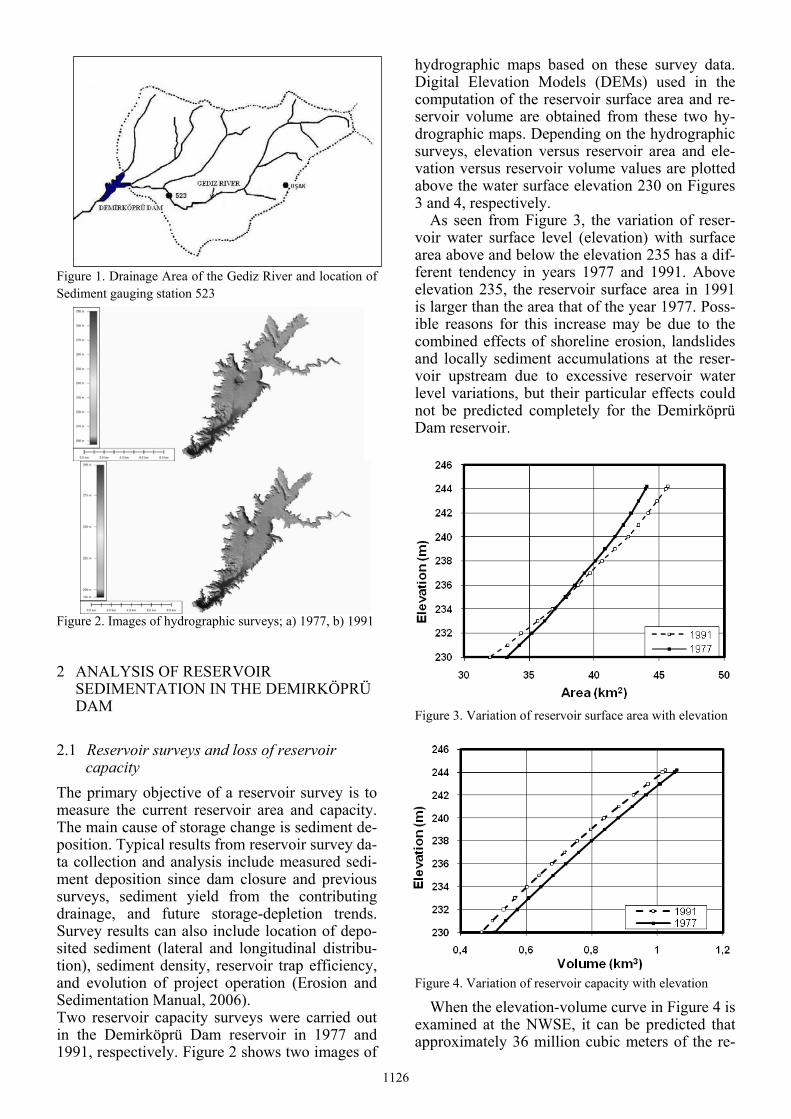
Figure 1. Drainage Area of the Gediz River and location of Sediment gauging station 523
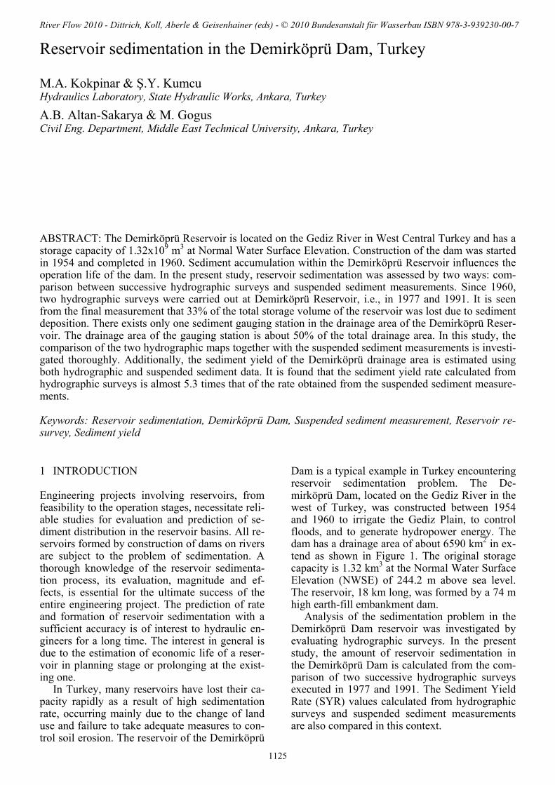
Figure 2. Images of hydrographic surveys; a) 1977, b) 1991
2 ANALYSIS OF RESERVOIR SEDIMENTATION IN THE DEMIRKÖPRÜ DAM
2.1 Reservoir surveys and loss of reservoir capacity
The primary objective of a reservoir survey is to measure the current reservoir area and capacity. The main cause of storage change is sediment de-position. Typical results from reservoir survey da-ta collection and analysis include measured sedi-ment deposition since dam closure and previous surveys, sediment yield from the contributing drainage, and future storage-depletion trends. Survey results can also include location of depo-sited sediment (lateral and longitudinal distribu-tion), sediment density, reservoir trap efficiency, and evolution of project operation (Erosion and Sedimentation Manual, 2006). Two reservoir capacity surveys were carried out in the Demirköprü Dam reservoir in 1977 and 1991, respectively. Figure 2 shows two images of
hydrographic maps based on these survey data. Digital Elevation Models (DEMs) used in the computation of the reservoir surface area and re-servoir volume are obtained from these two hy-drographic maps. Depending on the hydrographic surveys, elevation versus reservoir area and ele-vation versus reservoir volume values are plotted above the water surface elevation 230 on Figures 3 and 4, respectively.
As seen from Figure 3, the variation of reser-voir water surface level (elevation) with surface area above and below the elevation 235 has a dif-ferent tendency in years 1977 and 1991. Above elevation 235, the reservoir surface area in 1991 is larger than the area that of the year 1977. Poss-ible reasons for this increase may be due to the combined effects of shoreline erosion, landslides and locally sediment accumulations at the reser-voir upstream due to excessive reservoir water level variations, but their particular effects could not be predicted completely for the Demirköprü Dam reservoir.
Figure 3. Variation of reservoir surface area with elevation
Figure 4. Variation of reservoir capacity with elevation
When the elevation-volume curve in Figure 4 is examined at the NWSE, it can be predicted that approximately 36 million cubic meters of the re-
1126
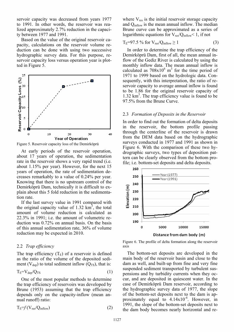
servoir capacity was decreased from years 1977 to 1991. In other words, the reservoir was rea-lized approximately 2.7% reduction in the capaci-ty between 1977 and 1991.
Based on the value of the original reservoir ca-pacity, calculations on the reservoir volume re-duction can be done with using two successive hydrographic survey data. For this purpose, re-servoir capacity loss versus operation year is plot-ted in Figure 5.
Figure 5. Reservoir capacity loss of the Demirköprü
At early periods of the reservoir operation, about 17 years of operation, the sedimentation rate in the reservoir shows a very rapid trend (i.e. about 1.15% per year). However, for the next 15 years of operation, the rate of sedimentation de-creases remarkably to a value of 0.24% per year. Knowing that there is no upstream control of the Demirköprü Dam, technically it is difficult to ex-plain about this 5 fold reduction in the sedimenta-tion rate.
If the last survey value in 1991 compared with the original capacity value of 1.32 km3, the total amount of volume reduction is calculated as 22.3% in 1991; i.e. the amount of volumetric re-duction was 0.72% on annual basis. On the basis of this annual sedimentation rate, 36% of volume reduction may be expected in 2010.
2.2 Trap efficiency The trap efficiency (TE) of a reservoir is defined as the ratio of the volume of the deposited sedi-ment (Vdep) to total sediment inflow (QTS), that is: TE=Vdep/QTS (1)
One of the most popular methods to determine the trap efficiency of reservoirs was developed by Brune (1953) assuming that the trap efficiency depends only on the capacity-inflow (mean an-nual runoff) ratio: TE=f (Vres/Qinflow) (2)
where Vres is the initial reservoir storage capacity and Qinflow is the mean annual inflow. The median Brune curve can be approximated as a series of logarithmic equations for Vres/Qinflow< 1, if not TE=97.5 % for Vres/Qinflow ≥ 1 (3)
In order to determine the trap efficiency of the Demirköprü Dam, first of all, the mean annual in-flow of the Gediz River is calculated by using the monthly inflow data. The mean annual inflow is calculated as 708x106 m3 for the time period of 1971 to 1999 based on the hydrologic data. Con-sequently, with this interpretation, the ratio of re-servoir capacity to average annual inflow is found to be 1.86 for the original reservoir capacity of 1.32 km3. The trap efficiency value is found to be 97.5% from the Brune Curve.
2.3 Formation of Deposits in the Reservoir In order to find out the formation of delta deposits in the reservoir, the bottom profile passing through the centerline of the reservoir is drawn from the DEM data based on the hydrographic surveys conducted in 1977 and 1991 as shown in Figure 6. With the comparison of these two hy-drographic surveys, two types of deposition pat-tern can be clearly observed from the bottom pro-file; i.e. bottom-set deposits and delta deposits.
Figure 6. The profile of delta formation along the reservoir axis
The bottom-set deposits are developed in the main body of the reservoir basin and close to the dam as well, and built-up from fine and very fine suspended sediment transported by turbulent sus-pensions and by turbidity currents when they oc-cur, and are deposited in quiescent water. In the case of Demirköprü Dam reservoir, according to the hydrographic survey data of 1977, the slope of the bottom-set deposits next to the dam is ap-proximately equal to 4.14x10⁻⁴. However, in 1991, the slope of the bottom-set deposits next to the dam body becomes nearly horizontal and re-
1127
duced to a value of 3.40x10⁻⁴. In addition, within this period approximate increase in the bed level just upstream of the dam body due to the fine se-diment deposits is 3.2 m in total, i.e. 0.23 m in-crease per year.
The bed-load transported in the Gediz River, which is the coarse-grained particles, begin to de-posit immediately at the head reaches of backwa-ter. This is due to an increase in the depth and the cross-sectional area of the flow which results in a reduction of velocity, and thus, in the sediment transport capacity. This deposition continues along the reservoir until a section where the ve-locity becomes too small to maintain any trans-portation. The result is the formation of a delta as given in Fig. 6. It is clearly seen that at the up-stream region of the reservoir, a deltaic-shaped deposit formation exists in the reservoir which is a typical non-uniform two-phase inflow case into shallow reservoirs. The topset slopes of the del-taic deposit formations can be determined as 1.99x10⁻³ for 1977 and 1.36x10⁻³ for 1991, re-spectively. Similarly, the foreset slopes formed at the head of the delta formation have been found to be 8.93x10⁻³ for 1977 and 1.36x10⁻² for 1991, respectively. The ratios of the foreset slope to the-topset slope are calculated as 4.48 and 10 for years 1977 and 1991, respectively. Borland (1971) found that the average foreset slope is 6.5 times the topset slope in the reservoirs of United States. However, Smith et al. (1964) reported that some steeper slopes have been observed, where the measured foreset slope of delta was 100 times the topset slope (Batuca and Jordaan, 2000). Therefore, it may vary from one reservoir to another. For example, Kokpinar et al. (2008) found the ratio of the foreset to topset slope as 37.9 at the Seyhan Dam reservoir in Turkey.
The separation between the topset and foreset deposits occurs by virtue of a pivot point at a lo-cation which depends primarily on the reservoir operation and on the existing channel slope in the delta area. The pivot points at the delta of the Demirköprü Dam deposits in years 1977 and 1991 are clearly seen in Figure 6. Referring to this figure one can conclude that the progress speed of the delta towards the dam body is 25 m/year in the Demirköprü Dam reservoir between 1977 and 1991. However, Batuca and Jordaan (2000) noted that depending on the reservoir hy-drology, hydraulics, sediment transport, size and configuration, the speed of progress of the delta is variable from 50 to 200 m per annum.
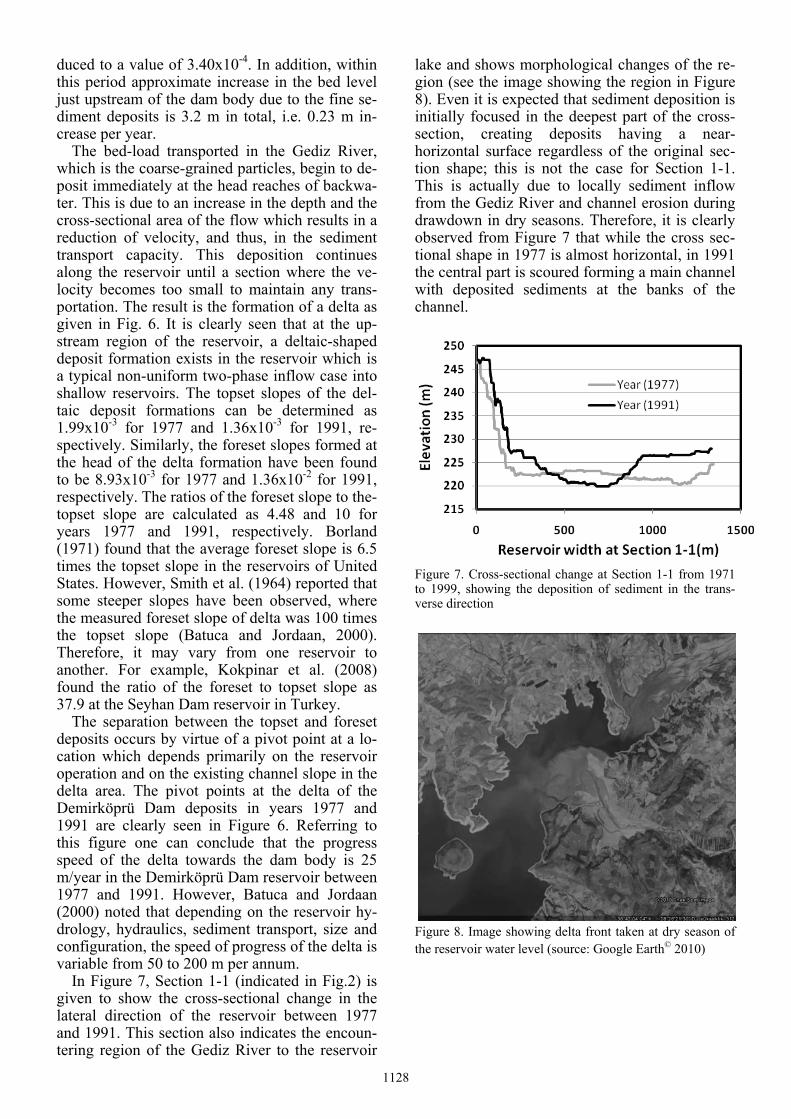
In Figure 7, Section 1-1 (indicated in Fig.2) is given to show the cross-sectional change in the lateral direction of the reservoir between 1977 and 1991. This section also indicates the encoun-tering region of the Gediz River to the reservoir
lake and shows morphological changes of the re-gion (see the image showing the region in Figure 8). Even it is expected that sediment deposition is initially focused in the deepest part of the cross-section, creating deposits having a near-horizontal surface regardless of the original sec-tion shape; this is not the case for Section 1-1. This is actually due to locally sediment inflow from the Gediz River and channel erosion during drawdown in dry seasons. Therefore, it is clearly observed from Figure 7 that while the cross sec-tional shape in 1977 is almost horizontal, in 1991 the central part is scoured forming a main channel with deposited sediments at the banks of the channel.
Figure 7. Cross-sectional change at Section 1-1 from 1971 to 1999, showing the deposition of sediment in the trans-verse direction
Figure 8. Image showing delta front taken at dry season of the reservoir water level (source: Google Earth© 2010)
1128
3 SUSPENDED SEDIMENT MEASUREMENTS
The earliest and very limited sediment measure-ments on the Gediz River were made in the plan-ning stage of the Demirköprü Dam Project. Be-fore this date, no measurements of sediment concentration were available in the Gediz River except for a single series at a gauging station dur-ing February 1941. Even though these measure-ments showed a sediment concentration of 2% to 4.5 % by volume, it was considered that these values did not indicate the average concentration. Therefore, in the planning stage, a value of 0.5% was estimated to be representative of the sedi-ment concentration of the average annual reser-voir inflow of 22.4 m3/s (annual inflow volume is 708x106 m3).
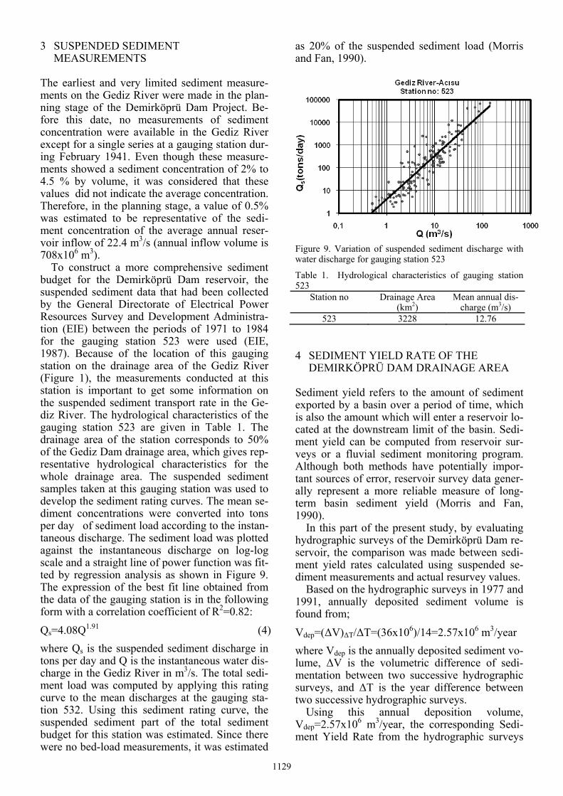
To construct a more comprehensive sediment budget for the Demirköprü Dam reservoir, the suspended sediment data that had been collected by the General Directorate of Electrical Power Resources Survey and Development Administra-tion (EIE) between the periods of 1971 to 1984 for the gauging station 523 were used (EIE, 1987). Because of the location of this gauging station on the drainage area of the Gediz River (Figure 1), the measurements conducted at this station is important to get some information on the suspended sediment transport rate in the Ge-diz River. The hydrological characteristics of the gauging station 523 are given in Table 1. The drainage area of the station corresponds to 50% of the Gediz Dam drainage area, which gives rep-resentative hydrological characteristics for the whole drainage area. The suspended sediment samples taken at this gauging station was used to develop the sediment rating curves. The mean se-diment concentrations were converted into tons per day of sediment load according to the instan-taneous discharge. The sediment load was plotted against the instantaneous discharge on log-log scale and a straight line of power function was fit-ted by regression analysis as shown in Figure 9. The expression of the best fit line obtained from the data of the gauging station is in the following form with a correlation coefficient of R2=0.82: Qs=4.08Q1.91 (4) where Qs is the suspended sediment discharge in tons per day and Q is the instantaneous water dis-charge in the Gediz River in m3/s. The total sedi-ment load was computed by applying this rating curve to the mean discharges at the gauging sta-tion 532. Using this sediment rating curve, the suspended sediment part of the total sediment budget for this station was estimated. Since there were no bed-load measurements, it was estimated
as 20% of the suspended sediment load (Morris and Fan, 1990).
Figure 9. Variation of suspended sediment discharge with water discharge for gauging station 523
Table 1. Hydrological characteristics of gauging station 523
Station no Drainage Area (km2)
Mean annual dis-charge (m3/s)
523 3228 12.76
4 SEDIMENT YIELD RATE OF THE DEMIRKÖPRÜ DAM DRAINAGE AREA
Sediment yield refers to the amount of sediment exported by a basin over a period of time, which is also the amount which will enter a reservoir lo-cated at the downstream limit of the basin. Sedi-ment yield can be computed from reservoir sur-veys or a fluvial sediment monitoring program. Although both methods have potentially impor-tant sources of error, reservoir survey data gener-ally represent a more reliable measure of long-term basin sediment yield (Morris and Fan, 1990).
In this part of the present study, by evaluating hydrographic surveys of the Demirköprü Dam re-servoir, the comparison was made between sedi-ment yield rates calculated using suspended se-diment measurements and actual resurvey values.
Based on the hydrographic surveys in 1977 and 1991, annually deposited sediment volume is found from; Vdep=(ΔV)ΔT/ΔT=(36x106)/14=2.57x106 m3/year where Vdep is the annually deposited sediment vo-lume, ΔV is the volumetric difference of sedi-mentation between two successive hydrographic surveys, and ΔT is the year difference between two successive hydrographic surveys.
Using this annual deposition volume, Vdep=2.57x10⁶ m3/year, the corresponding Sedi-ment Yield Rate from the hydrographic surveys
1129

(SYR)HS can be calculated with a drainage area A of 6590 km2 as, (SYR)HS= Vdep/A=389 m3/year/km2 On the other hand, using Eq. (4) and the mean annual inflow discharge, Q=22.4 m3/s into the re-servoir, the weight of the daily transported sus-pended sediment can be obtained as Qs=1547.5 tons/day. On annual basis it will be, Qs=564841 tons/year. When no field measurement data are available, US Soil Conservation Service recom-mended some design values for the 50 years’ spe-cific weight of deposited sediments (Batuca and Jordan, 2000). A value of 1400 kg/m3 is accepted in this study, as nearly the average value of the mixture in equal parts of silt and sand. Including the bed-load to suspended sediment load as 20% of suspended load, then the volume of the depo-sited sediment can be estimated as, Vdep=484148 m3/year. The corresponding Sediment Yield Rate from the suspended sediment measurements (SYR)meas can be calculated with a drainage area A of 6590 km2 as, (SYR)meas= Vdep/A=73.46 m3/year/km2
If one compares these two calculated SYR val-ues, one from the hydrographic survey data, (SYR)HS, and another from the suspended sedi-ment measurements (SYR)meas, it can be seen that (SYR)HS is almost five times higher than the (SYR)meas value. The difference is generally due to insufficient number of measurement records during flood flows when high amount of sedi-ment transport occurs in the Gediz River. Another important point is the lack of bed-load measure-ments in the gauging station. Since bed-load gen-erally constitutes significant part of the delta de-posits as in the Demirköprü Dam reservoir, the approximation of taking the bed-load as 20% of the suspended sediment is suspicious and estima-tion of the bed-load is not highly reliable based on this assumption.
5 CONCLUSIONS
The following conclusions can be drawn from the results of this study: 1. The hydrographic surveys indicated that 36
percent of the total capacity of the De-mirköprü Dam was lost within 50 years of the reservoir operation.
2. The forms of the delta deposits are investigated in detail. The topset slopes of the delta were calculated as 1.99x10⁻³ for 1977 and 1.36x10⁻³ for 1991, respectively. Foreset slopes of the delta were calculated as 8.93x10⁻³ for 1977
and 1.36x10⁻² for 1991, respectively. The ra-tios of the foreset slope to the topset slope are calculated as 4.48 and 10 for years 1977 and 1991, respectively.
3. Depending on the last hydrographic survey da-ta in 1991, it was measured that the distance between the pivot of the delta deposits and the dam body was about 12.5 km. It was ob-served that the delta deposit approaches to-wards the dam body with a speed of 25 m/year.
4. Both using deposited volumes obtained from the hydrographic survey data and suspended sediment measurement data obtained from the sampling station, SYR of the Gediz River Drainage Area was calculated as 389 m3/year/km2 and 73.46 m3/yr/km2, respec-tively. The difference between these two SYR values is expected mainly due to lack of insufficient number of measurements for suspended load and no bed-load measure-ments during flood events.
ACKNOWLEDGEMENTS
This work was developed within a research project supported by The Scientific and Technol-ogical Research Council of Turkey (TUBITAK) under the project no: 105G098. The authors wish to acknowledge the contribution of TUBITAK.
REFERENCES
Batuca, D.G. & Jordan, J.M. 2000. Silting and Desilting of Reservoirs. Rotterdam: Balkema.
Borland, W.M. 1971. Reservoir Sedimentation, River Me-chanics, H.W. Shen, Ed., Water Resources Publications, Ch. 29, pp. 1-38
Brune, G.M. 1953. Trap efficiency of reservoirs. Trans. Am. Geoph. Union, 34(3). EIE, 1987. Türkiye Akarsularının Sediment Gözlemleri ve
Sediment Taşınım Miktarları, EIE yayınları, Türkiye. Erosion and Sedimentation Manual.2006. USBR Technical
Service Center, Sedimentation and River Hydraulics Group, Denver, Colorado.
Kokpinar, M.A., Altan-Sakarya, A.B., Kumcu, Ş.Y., & Go-gus, M. 2008. Assessment of Reservoir Sedimentation in the Seyhan Dam, Turkey, Proceedings of the Interna-tional Conference on Fluvial Hydraulics, River Flow 2008, Cesme, Izmir, Turkey, pp.1229-1234.
Morris, G.L. & Fan, J. 1997. Reservoir Sedimentation Handbook. New York: McGraw Hill Publication.
Smith, W.U., Vetter, C.P. & Cumming, C.B.1964. Com-prehensive survey of sedimentation in Lake Mead, 1948-1949, Prof. Pap.295, USGS, Washington D.C.
1130