REPORT NO 002 CALDERDALE STRATEGIC MODEL UPDATE
174
REPORT N O 002 CALDERDALE STRATEGIC MODEL UPDATE LOCAL MODEL VALIDATION REPORT (LMVR) CONFIDENTIAL JUNE 2015
Transcript of REPORT NO 002 CALDERDALE STRATEGIC MODEL UPDATE
REPORT NO 002
CALDERDALE STRATEGIC MODEL UPDATE LOCAL MODEL VALIDATION REPORT (LMVR)
CONFIDENTIAL JUNE 2015

Type of document (version) Confidential Project no: 70006056 Date: June 2015
– WSP | Parsons Brinckerhoff Three White Rose Office Park Millshaw Park Lane Leeds LS11 0DL Tel: +44(0 113 395 6200 Fax: +44(0) 113 395 6201 www.wspgroup.com www.pbworld.com
CALDERDALE STRATEGIC MODEL UPDATE LOCAL MODEL VALIDATION REPORT Calderdale Metropolitan Borough Council

Q U A L I T Y M A N A G E M E N T ISSUE/REVISION FIRST ISSUE REVISION 1 REVISION 2 REVISION 3
Remarks DRAFT FINAL
Date 13 May 2015 24 June 2015
Prepared by Michael Johns Michael Johns
Signature
Checked by Alan Cowan /
Ashley Russell
Ashley Russell
Signature
Authorised by Adrian Kemp Alan Cowan
Signature
Project number 70006056 70006056
Report number 001 002
File reference T:\70006056 - Calderdale Strategic Transport\C Documents\Reports\CSTM LMVR\150623 CSTM LMVR_WSPPB Format.docx

ii
Calderdale Strategic Model Update WSP | Parsons Brinckerhoff Calderdale Metropolitan Borough Council Project No 70006056 Confidential May 2015
TABLE OF CONTENTS 1 INTRODUCTION ...........................................................................1
2 MODEL OVERVIEW .....................................................................2
3 SURVEY DATA AND COLLECTION & ANALYSIS .....................6
4 NETWORK DEVELOPMENT .....................................................26
5 MATRIX DEVELOPMENT ..........................................................28
6 CALIBRATION AND VALIDATION RESULT.............................34
7 CONCLUSION ............................................................................52

iii
Calderdale Strategic Model Update WSP | Parsons Brinckerhoff Calderdale Metropolitan Borough Council Project No 70006056 Confidential May 2015
T A B L E S TABLE 2.1 - GENERALISED COST PARAMETERS, PENCE PER MINUTE (PPM) ........... 3 TABLE 2.2 - GENERALISED COST PARAMETERS, PENCE PER KILOMETRE (PPK) ..... 3 TABLE 3.1 - RSI LOCATIONS ........................................................................................... 7 TABLE 3.2 - RSI INTERVIEWS & SAMPLE SIZE ............................................................... 9 TABLE 3.3 - PROJECT SPECIFIC TEMPORARY ATC SITES ......................................... 10 TABLE 3.4 - VEHICLE CLASSIFICATION ........................................................................ 13 TABLE 3.5 - PERMANENT ATC SITES............................................................................ 13 TABLE 3.6 - PERMANENT ATC VEHICLE SPLITS .......................................................... 16 TABLE 3.7 - HGV VEHICLE SPLITS ................................................................................ 16 TABLE 3.8 - SELECTED TRADS SITES .......................................................................... 17 TABLE 3.9 - MCC SITES ................................................................................................. 18 TABLE 3.10 - SCREENLINE DESCRIPTION ................................................................... 22 TABLE 3.11 - JOURNEY TIME ROUTE DESCRIPTION ................................................... 24 TABLE 5.1 - RSI EXPANSION FACTORS BY INTERVIEW DIRECTION AND VEHICLE
TYPE .............................................................................................. 29 TABLE 5.2 - INDIVIDUAL RSI MATRIX TOTALS (VEHICLES) ......................................... 30 TABLE 5.3 - RSI MATRIX TOTALS (PCU) ....................................................................... 32 TABLE 5.4 - MATRIX TOTALS (PCUS) ............................................................................ 33 TABLE 6.1 - CONVERGENCE CRITERIA ........................................................................ 35 TABLE 6.2 - AM PEAK CONVERGENCE RESULTS ........................................................ 35 TABLE 6.3 - INTER PEAK CONVERGENCE RESULTS .................................................. 35 TABLE 6.4 - PM PEAK CONVERGENCE RESULTS ........................................................ 35 TABLE 6.5 - ASSIGNMENT ACCEPTABILITY GUIDELINES ........................................... 37 TABLE 6.6 - AM PEAK CALIBRATION AND VALIDATION RESULTS .............................. 37 TABLE 6.7 - AM PEAK GEH SUMMARY .......................................................................... 38 TABLE 6.8 - INTER PEAK CALIBRATION AND VALIDATION RESULTS ......................... 38 TABLE 6.9 - INTER PEAK GEH SUMMARY .................................................................... 39 TABLE 6.10 - PM PEAK CALIBRATION AND VALIDATION RESULTS ............................ 39 TABLE 6.11 - PM PEAK GEH SUMMARY ........................................................................ 40 TABLE 6.12 - HIGHWAY MODEL SCREENLINE VALIDATION RESULTS – AM PEAK ... 41 TABLE 6.13 - HIGHWAY MODEL SCREENLINE VALIDATION RESULTS – INTER
PEAK .............................................................................................. 42 TABLE 6.14 - HIGHWAY MODEL SCREENLINE VALIDATION RESULTS – PM PEAK ... 43 TABLE 6.15 - AM PEAK HOUR JOURNEY TIME ROUTE COMPARISON ....................... 45 TABLE 6.16 - INTER PEAK HOUR JOURNEY TIME ROUTE COMPARISON .................. 47 TABLE 6.17 - PM PEAK HOUR JOURNEY TIME ROUTE COMPARISON ....................... 49

iv
Calderdale Strategic Model Update WSP | Parsons Brinckerhoff Calderdale Metropolitan Borough Council Project No 70006056 Confidential May 2015
F I G U R E S FIGURE 2.1 - EXTENT OF TRANSPORT MODEL AREA................................................... 5 FIGURE 3.1 - RSI LOCATIONS ......................................................................................... 8 FIGURE 3.2 - PROJECT SPECIFIC TEMPORARY ATC SITES ....................................... 12 FIGURE 3.3 - PERMANENT ATC SITES ......................................................................... 15 FIGURE 3.4 - TEMPORARY CMBC ATC SITES .............................................................. 16 FIGURE 3.5 - TRADS SITES ........................................................................................... 17 FIGURE 3.6 - MCC AND ANPR SURVEYS ...................................................................... 19 FIGURE 3.7 - MCC SURVEYS SOUTH OF HALIFAX ...................................................... 20 FIGURE 3.8 - SCREENLINE LOCATIONS ....................................................................... 21 FIGURE 3.9 - JOURNEY TIME ROUTES ......................................................................... 23 FIGURE 4.1 - EXTENT OF CSTM 2014 MODELLED AREA ............................................. 26 FIGURE 6.1 - AM PEAK SUMMARY ................................................................................ 50 FIGURE 6.2 - INTER PEAK SUMMARY ........................................................................... 51 FIGURE 6.3 - PM PEAK SUMMARY ................................................................................ 51
A P P E N D I C E S A P P E N D I X A MODEL FILES A P P E N D I X B MODEL ZONE PLANS
APPENDIX B-1 HALIFAX TOWN CENTRE ZONE STRUCTURE APPENDIX B-2 MODEL STUDY AREA ZONE STRUCTURE APPENDIX B-3 OUTER ZONE STRUCTURE
A P P E N D I X C RSI ORIGIN - DESTINATION PLOTS A P P E N D I X D CMBC TEMPORARY ATC SITES A P P E N D I X E ROUTING VALIDATION - ORIGIN DESTINATION TREES A P P E N D I X F CALIBRATION / VALIDATION RESULTS A P P E N D I X G JOURNEY TIME ROUTE RESULTS

1
Calderdale Strategic Model Update WSP | Parsons Brinckerhoff Calderdale Metropolitan Borough Council Project No 70006056 Confidential May 2015
1 INTRODUCTION 1.1 BACKGROUND
1.1.1 WSP | Parsons Brinckerhoff has been commissioned by Calderdale Metropolitan Borough Council (CMBC) under the Metro Framework to update and extend the existing Calderdale Strategic Transport Model (CSTM) to represent the current 2014 travel patterns and highway network conditions, in order to enable assessment of proposed developments and infrastructure schemes, and more specifically test the implications of delivery of CMBC schemes identified as part of the West Yorkshire plus Transport Fund (WY+TF).
1.1.2 A SATURN strategic model of the Calderdale area covering Halifax town and the adjacent centres was developed by Mouchel in 2008 and further expanded in 2009. The CSTM represented travel patterns that occurred across the key road network within the Borough, during a typical 2009 weekday. The model was developed to assess development options associated with Calderdale’s Local Development Framework (LDF) and also to enable testing of a series of highway improvements options.
1.1.3 The 2009 CSTM inherited model formed the basis of the update to 2014 travel patterns and highway network conditions taking account of all significant highway network changes and developments since the model’s previous update.
1.1.4 The 2014 model has been developed in accordance with the Department for Transport (DfT) web based Transport Analysis Guidance (WebTAG) on http://www.dft.gov.uk/webtag along with the WebTAG 2 ‘Guidance for the Technical Project Manager.’ These provide detailed guidance on the appraisal of transport projects and wider advice on scoping and carrying out transport studies. The guidance is a requirement for all projects/studies that require government approval.
1.2 REPORT PURPOSE AND STRUCTURE
1.2.1 This report is a Local Model Validation Report (LMVR) for the 2014 base year SATURN modelling. This report details the development, calibration and validation of the traffic model to 2014 observed traffic conditions.
1.2.2 The structure and content of this LMVR is based on guidance contained in WebTAG ‘Guidance for the Technical Project Manager’ Appendix D (January 2014).
1.2.3 The structure of this report is as follows:
Section 2: Model Overview
Section 3: Survey Data Collection & Analysis
Section 4: Network Development
Section 5: Matrix Development
Section 6: Assignment Calibration & Validation
Section 7: Summary

2
Calderdale Strategic Model Update WSP | Parsons Brinckerhoff Calderdale Metropolitan Borough Council Project No 70006056 Confidential May 2015
2 MODEL OVERVIEW 2.1 INTRODUCTION
2.1.1 This section of the report details the specification of the CSTM. Detailed information regarding the construction of the network and matrices can be found in Section 4 and Section 5 of this report.
2.2 MODELLING SOFTWARE VERSION
2.2.1 SATURN (Simulation and Assignment of Traffic in Urban Road Networks) Version 11.3.07K was used for the updating of the CSTM. SATURN is a recognised industry-standard transport modelling tool providing:
A modelling and assessment platform supported by CMBC, WYCA and the Highways Agency (HA);
WebTAG compliance in terms of structure and model ‘convergence’ and output statistics essential for scheme appraisal and the determination of robustness in decision-making and scheme design; and
A comprehensive and efficient data input and analysis capability
2.3 BASE YEAR
2.3.1 The updated base year of the CSTM is 2014. This is determined by the Road Side Interview traffic data commissioned for this study which was collected in June 2014 and supplemented by additional junction and link surveys from April and October 2014.
2.4 TIME PERIODS
2.4.1 The model was developed for the following time periods outlined below. The inter peak hour model is taken as an average hour between the inter peak period of 10:00 to 16:00.
Average weekday AM Peak Hour: 08:00 - 09:00
Average weekday Inter Peak Hour: 10:00 - 16:00
Average weekday PM Peak Hour: 17:00 - 18:00
2.5 USER CLASSES
2.5.1 In the CSTM, as in most conventional highway assignment models, routeing of trips between origin and destination zones is dictated by weightings applied to time and distance. The weightings are based on central government research into the values of time and the perceived costs of the travel of road users.
2.5.2 SATURN permits ‘multiple user class’ assignment in which vehicles and users (identified by vehicle type and journey purpose as below) may be assigned onto the highway network. In CSTM 2014 the assignment model comprises six user classes as follows:
UC1: Cars on employers’ business
UC2: Cars commuting
UC3: Cars ‘other trips’

3
Calderdale Strategic Model Update WSP | Parsons Brinckerhoff Calderdale Metropolitan Borough Council Project No 70006056 Confidential May 2015
UC4: Light Goods Vehicles (LGV)
UC5: Heavy Goods Vehicles (OGV 1)
UC6: Heavy Goods Vehicles (OGV 2)
2.5.3 Public Service Vehicles (PSVs) i.e. buses have not been included in the model as a distinct user class. Instead they have been represented on the network as fixed flows along a defined route with a peak hour frequency relevant to the respective peak hour modelled. Defining buses in this manner means their impact in terms of congestion and subsequently journey times around the model is captured and their routing realistic in terms of current bus provision when traffic surveys were undertaken.
2.6 GENERALISED COST PARAMETERS
2.6.1 Generalised costs were calculated using values of time, GDP growth rates, purpose splits, and vehicle operating costs recommended by the DfT for use in economic appraisals of transport projects in England, as presented in the WebTAG Databook (November 2014).
2.6.2 The values calculated for use in the base year models are shown in Table 2.1 and Table 2.2. Table 2.1 outlines the Pence per Minute (PPM) values by peak period and vehicle class, whilst Table 2.2 shows this in terms of Pence per Kilometre (PPK).
Table 2.1 - Generalised Cost Parameters, Pence per Minute (PPM)
PEAK CAR
EMPLOYERS BUSINESS
CAR COMMUTING CAR OTHER LGV OGV 1 OGV 2
AM 54.55 13.52 17.25 24.19 24.87 24.87
IP 53.29 13.42 17.93 24.19 24.87 24.87
PM 52.44 13.23 18.45 24.19 24.87 24.87
Table 2.2 - Generalised Cost Parameters, Pence per Kilometre (PPK)
PEAK CAR
EMPLOYERS BUSINESS
CAR COMMUTING CAR OTHER LGV OGV 1 OGV 2
AM 13.74 10.03 10.03 10.44 22.97 48.32
IP 13.74 10.03 10.03 10.44 22.97 48.32
PM 13.74 10.03 10.03 10.44 22.97 48.32
2.6.3 The assignment technique that has been used is Wardrop Equilibrium Assignment which is the default assignment procedure within SATURN. Wardrop’s Principle of traffic equilibrium states that:
“Traffic arranges itself on congested networks such that the cost of travel on all routes used between each O-D pair is equal to the minimum cost of travel and all unused routes have equal or greater cost.”

4
Calderdale Strategic Model Update WSP | Parsons Brinckerhoff Calderdale Metropolitan Borough Council Project No 70006056 Confidential May 2015
2.7 2.7 PASSENGER CAR UNITS
2.7.1 Standard factors to convert each vehicle type in to passenger car units (pcu) have been taken from TAG Unit M3.1 Highway Assignment Modelling Appendix D - Section D7 Conversion to Passenger Car Units (January 2014). These are:
Car: 1.0
Light Goods Vehicle: 1.0
HGV on Motorway and all-purpose dual carriageway: 2.5
HGV on other road types: 2.0
2.7.2 In an assignment model, it is not possible to allocate different PCU factors to a particular user class according to link type. Guidance is not given on this aspect in WebTAG, so a default pcu factor of 2.0 has been applied to all HGVs, since the majority of links within the model are not motorway or all-purpose dual carriageway.
2.8 TRANSPORT MODEL AREA
2.8.1 The CSTM contains a total of 2,297 nodes and 5,519 links. The model covers the Calderdale District representing all key highway links and junctions with appropriate minor road network detail in the key towns of the district.
2.8.2 The coverage of the model includes the M62 with the connections from Junction 22 and the A672, Junction 23 and the A640, Junction 24 and the A629, Junction 25 and the A644, and Junction 26 and the A58. All major routes through the district to the key towns are represented including the A646 to Hebden Bridge and Todmorden, A629 to Illingworth, A6036 to Shelf, A644 and A641 to Brighouse.
2.8.3 The model includes urbanised areas such as Halifax town centre, Elland and Brighouse, in considerable detail with the local roads included within the assignment as well as major strategic roads.
2.8.4 The transport model area and links included within the model are shown in Figure 2.1 below.

5
Calderdale Strategic Model Update WSP | Parsons Brinckerhoff Calderdale Metropolitan Borough Council Project No 70006056 Confidential May 2015
Figure 2.1 - Extent of Transport Model Area
2.9 ZONING SYSTEM
2.9.1 The zone system of the CSTM has been designed such that it is sufficiently detailed to credibly represent trip loading points from different land uses onto the transport network. In total there are 278 zones in the CSTM. Plans of the zone system are included in Appendix B.
2.9.2 Within Halifax, additional zones were created by splitting the original CSTM zones during the validation process in order to provide sufficient detail to accurately represent observed traffic conditions, as shown in figure B-1.
2.9.3 South of the M62, the zone loading was adjusted to create single zones loading onto each entry point into the network. This was essential, as each corridor as a traffic count, with many of them also hosting RSI sites, and the only way to validate these counts at this level of detail is to provide a separate zone. Further accuracy in this area can be obtained by extending the detailed simulation area into Kirklees, which is the aim of a future update to the model.
2.9.4 Further east along the M62 up to Junction 26, additional detail was added with seven zones introduced at specific loading points, rather than the single zone (33) used in the original model. The number of external zones at the eastern and western fringes of the model was substantially reduced as the original model had multiple zones loading onto the same point at edges of the network. The revised CSTM zone structure involves a single zone (813) loading onto the western end of the M62 and another zone (827) loading onto the eastern end of the M62 as shown in figure B-3.
2.9.5 Zone loading was amended in many instances within the main simulation network by ensuring zones loading onto a single ‘spigot’ access link representing an existing road, logical in relation to the area covered by the model zone. The original model was found to contain a number of zones loading across multiple spigots and across links This arrangement did not allow for counts to be interpreted or matched in a logical way, and also caused major problems with model convergence.

6
Calderdale Strategic Model Update WSP | Parsons Brinckerhoff Calderdale Metropolitan Borough Council Project No 70006056 Confidential May 2015
3 SURVEY DATA AND COLLECTION & ANALYSIS
3.1 INTRODUCTION
3.1.1 To produce a robust and ‘fit for purpose’ model, a suitable data collection exercise was undertaken by SkyHigh-CountOnUs in June 2014, under the instruction of CMBC, including Road Side Interviews (RSIs), supplemented by additional junction and link data collected in April and October 2014 as part of parallel studies on the A629 corridor.
3.1.2 This section provides a summary of the survey data obtained and how it was processed in order for it to be used to create the base year SATURN model. The following data was collected for model development, or was already available via existing sources:
19 Road Side Interviews (RSIs)
10 ATC sites collected by SkyHigh-CountOnUs;
7 Automatic Traffic Counts (ATC) sites collected by NDC;
10 Permanent ATC Sites from http://www.c2traffic.co.uk;
133 Automatic Traffic Counts (ATC) sites from http://www.c2traffic.co.uk;
9 Highways Agency TRADS Count Sites
16 Manual Classified Counts (MCC) sites collected by NDC in April;
14 Manual Classified Counts (MCC) sites collected by NDC in October; and
1 ANPR site collected by SkyHigh-CountOnUs.

7
Calderdale Strategic Model Update WSP | Parsons Brinckerhoff Calderdale Metropolitan Borough Council Project No 70006056 Confidential May 2015
3.2 ROADSIDE INTERVIEW DATA
3.2.1 Table 3.1 details the location of the 19 RSIs.
Table 3.1 - RSI Locations
SITE ID
DESCRIPTION DATE
INTERVIEW DIRECTION
1 A58 Rochdale Road 17/06/2014 Eastbound
2 A646 Burnley road 10/06/2014 Eastbound
3 Moor End Road 10/06/2014 North-Westbound
4 Shroggs Road 10/06/2014 Southbound
5 Ovenden Road 18/06/2014 Southbound
6 Haley Hill 18/06/2014 South-Eastbound
7 Stainland Road 18/06/2014 Northbound
8 A629 Elland Wood Bottom 11/06/2014 Southbound
9 New Road 11/06/2014 Southbound
10 New Hey Road 24/06/2014 North-Eastbound
11 Clough Lane 24/06/2014 Eastbound
12 A641 Huddersfield Road 17/06/2014 Southbound
13 A644 Wakefield Road 17/06/2014 Eastbound
14 Walton Lane 17/06/2014 Northbound
15 Birkby Lane 19/06/2014 Eastbound
16 A58 Whitehall Road 19/06/2014 Eastbound
17 Bradford Road 12/06/2014 Northbound
18 Wade House Road 12/06/2014 North-Eastbound
19 A644 Brighouse & Denholme
Gate Road 12/06/2014 Southbound

8
Calderdale Strategic Model Update WSP | Parsons Brinckerhoff Calderdale Metropolitan Borough Council Project No 70006056 Confidential May 2015
Figure 3.1 - RSI Locations
3.2.2 Information on the following was obtained for each respondent:
Vehicle type
Number of occupants
Origin postcode for trip
Reason for being at origin
Destination postcode for trip
Reason for going to destination
3.2.3 RSIs were conducted between 07:00 and 19:00 on the respective survey date. Associated MCCs were also carried out over the same time period, on the same day as the relevant RSI in both directions, in order to gain a full understanding of the make-up and volume of traffic at each location.
3.2.4 Existing ATC information available from CMBC via http://www.c2traffic.co.uk, for temporary and permanent sites at comparable locations, was used to expand the MCC counts at the RSI sites in order to provide a more robust long-term average traffic count unaffected by disruptions associated with the RSIs themselves. Where no ATCs were available, the MCC associated with the RSI was used to expand the data.

9
Calderdale Strategic Model Update WSP | Parsons Brinckerhoff Calderdale Metropolitan Borough Council Project No 70006056 Confidential May 2015
3.2.5 Table 3.2 shows the number of logical face-to-face interviews in the interview direction and the proportion of the total traffic these represent. Logic checks were carried out, with data excluded if any key field related to the RSI record was incomplete. Appendix C contains origin and destination postcode plots for each RSI site. In certain instances, there are records which appear to be the wrong side of the RSI based on whether they are an origin or destination and the interview direction. Examination of these individual records does not show these interviews to be illogical definitively - they could be part of a linked trip or a logical journey for the specific respondent involved. It was decided to not exclude such records to ensure the data used was not biased by presumptions of travel patterns through the RSI sites.
Table 3.2 - RSI Interviews & Sample Size
SITE ID
DESCRIPTION INTERVIEW DIRECTION
LOGICAL JOURNEYS
INCOMPLETE / ILLOGICAL JOURNEYS
MCC INTERVIEW DIRECTION
LOGICAL SAMPLE RATE
MCC NON-INTERVIEW DIRECTION
1
A58 Rochdale Road between Lower
Brockwell Lane & Mill House Lane
EB 694 29 3996 17% 4426
2
A646 Burnley Road near Warley Wood
Avenue EB 1029 89 7378 14% 6868
3
Moor End Road travelling east before
Heath Hill Road NWB 751 192 1644 46% 1712
4
Shroggs Road in the bus stop opposite
Hebble Lane SB 691 122 3315 21% 3885
5
Ovenden Road opposite
Ovenden Way
SB 792 99 8877 9% 10580
6 Haley Hill toward A58
gyratory SEB 1006 250 6552 15% 3762
7
Stainland Road towards Calder & Hebble
Junction NB 872 94 7955 11% 6815
8
A629 Elland Wood Bottom in Bus stop
towards M62 SB 1143 109 14606 8% 12761
9 New Road north of
Forest Hill Road SB 521 96 1285 41% 1334
10
New Hey Road south of Dewsbury Road/Clough
Lane Crossroads NEB 597 168 4502 13% 4799
11
Clough Lane in the lay-by outside the Roundhill
Inn EB 819 166 7276 11% 7160
12
A641 Huddersfield Road towards
Huddersfield on grassed central reserve
SB 915 130 7957 11% 7557
13
A644 Wakefield Road towards M62 on
grassed central reserve EB 896 113 6902 13% 5456
14 Walton Lane north of
Highmoor Lane NB 1270 195 3530 36% 3217

10
Calderdale Strategic Model Update WSP | Parsons Brinckerhoff Calderdale Metropolitan Borough Council Project No 70006056 Confidential May 2015
SITE ID
DESCRIPTION INTERVIEW DIRECTION
LOGICAL JOURNEYS
INCOMPLETE / ILLOGICAL JOURNEYS
MCC INTERVIEW DIRECTION
LOGICAL SAMPLE RATE
MCC NON-INTERVIEW DIRECTION
15 Birkby Lane towards
Walton Lane EB 825 103 2905 28% 3081
16 A58 Whitehall Road
east of Westfield Lane EB 771 158 7993 10% 7833
17 Bradford Road south of
Mayfield Grove NB 817 95 5666 14% 5835
18 Wade House Road south of Brow Lane NEB 765 83 7439 10% 7659
19
A644 Brighouse & Denholme Gate Road between Shaw Lane and Bowl Shaw Lane
SB 1009 113 4335 23% 4881
3.2.6 Typical sample rates for RSIs generally line in the range of 10-20%. The samples achieved here are mostly within that range, with some sites being considerably better.
3.3 ATC DATA
3.3.1 Temporary ATCs were laid down for the purposes of this study to supplement existing ATC information available from CMBC via http://www.c2traffic.co.uk, for permanent and temporary sites. The existing data available from the above website, supplemented by project specific data collected, provides sufficient coverage to robustly develop the base model.
3.3.2 Table 3.3 below lists the Temporary ATCs commissioned for this study and parallel CMBC studies:
Table 3.3 - Project Specific Temporary ATC Sites REF SITE ID DESCRIPTION DIRECTION CLASSIFICATION DATE RANGE
162
3864 – 1/ Halifax
A629 Skircoat Road between Caygill Terrace and Heath Road Northbound Classified 02/04/2014 -
16/04/2014
162
3864 – 1/ Halifax
A629 Skircoat Road between Caygill Terrace and Heath Road Southbound Classified 02/04/2014 -
16/04/2014
163
3864 - 2/ Halifax
Huddersfield Road. Between Shaw Hill and Simmonds Lane Southbound Classified 02/04/2014 -
16/04/2014
163
3864 - 2/ Halifax
Huddersfield Road. Between Shaw Hill and Simmonds Lane Northbound Classified 02/04/2014 -
16/04/2014
164
3864 - 3/ Halifax
Freeschool Lane. Between Heath Street and Heath Villas Westbound Classified 02/04/2014 -
16/04/2014
164
3864 – 3/ Halifax
Freeschool Lane. Between Heath Street and Heath Villas Eastbound Classified 02/04/2014 -
16/04/2014
165 3864 - 4/
A646 Skircoat Moor Road. Between Lea Avenue and Rawson Avenue Westbound Classified 02/04/2014 -
16/04/2014

11
Calderdale Strategic Model Update WSP | Parsons Brinckerhoff Calderdale Metropolitan Borough Council Project No 70006056 Confidential May 2015
REF SITE ID DESCRIPTION DIRECTION CLASSIFICATION DATE RANGE Halifax
165 3864 – 4/ Halifax
A646 Skircoat Moor Road. Between Lea Avenue and Rawson Avenue Eastbound Classified 02/04/2014 -
16/04/2014
166
3864 - 5/ Halifax
Skircoat Green Road. Between Copley Lane and Skircoat Green Southbound Classified 02/04/2014 -
16/04/2014
166 3864 – 5/ Halifax
Skircoat Green Road. Between Copley Lane and Skircoat Green Northbound Classified 02/04/2014 -
16/04/2014
167 3864 – 6/ Halifax
A6026 Wakefield Road. Between Copley Lane and Cow Lane Westbound Classified 02/04/2014 -
16/04/2014
167 3864 – 6/ Halifax
A6026 Wakefield Road. Between Copley Lane and Cow Lane Eastbound Classified 02/04/2014 -
16/04/2014
168 3864 – 7/ Halifax
A629 Huddersfield Road. Between Exley Bank and A6026 Wakefield Road Southbound Classified 03/04/2014 -
16/04/2014
168 3864 – 7/ Halifax
A629 Huddersfield Road. Between Exley Bank and A6026 Wakefield Road Northbound Classified 03/04/2014 -
16/04/2014
236 9298 – 1 Bradford Old Road - South of Ploughcroft Lane Northbound Classified Jun-14
236 9298 – 1 Bradford Old Road - South of Ploughcroft Lane
Southbound
Classified Jun-14
237 9298 – 2 A58 Whitehall Road - Between Syke Lane and Rooks Lane Westbound Classified Jun-14
237 9298 – 2 A58 Whitehall Road - Between Syke Lane and Rooks Lane Eastbound Classified Jun-14
238 9298 - 3 B6114 Dewsbury Road, East of Whitwell Green Lane Westbound Classified Jun-14
238 9298 - 3 B6114 Dewsbury Road, East of Whitwell Green Lane Eastbound Classified Jun-14
239 9298 - 4 A6025 Park Road North of Park Wood Crematorium Northbound Classified Jun-14
239 9298 - 4 A6025 Park Road North of Park Wood Crematorium
Southbound
Classified Jun-14
240 9298 - 5 A646 Skircoat Moor Road East of Rocks Road Westbound Classified Jun-14

12
Calderdale Strategic Model Update WSP | Parsons Brinckerhoff Calderdale Metropolitan Borough Council Project No 70006056 Confidential May 2015
REF SITE ID DESCRIPTION DIRECTION CLASSIFICATION DATE RANGE
240 9298 - 5 A646 Skircoat Moor Road East of Rocks Road Eastbound Classified Jun-14
241 9298 – 6 Greetland Road – East of Norland Road Westbound Classified Jun-14
241 9298 – 6 Greetland Road – East of Norland Road Eastbound Classified Jun-14
242 9298 - 7 B6113 Saddleworth Road - East of Syke House Road Westbound Classified Jun-14
242 9298 – 7 B6113 Saddleworth Road - East of Syke House Road Eastbound Classified Jun-14
243 9298 – 8NB
A629 Huddersfield Road North of M62 Northbound Classified Jun-14
244 9298 – 9SB
Huddersfield Road Slip onto A629
Southbound
Classified Jun-14
245 9298 – 10 Calderdale Way (at bus stop area)
Southbound
Classified Jun-14
3.3.3 Figure 3.2 shows the location of the project specific ATC sites.
Figure 3.2 - Project Specific Temporary ATC Sites
3.3.4 The classified surveys are based on vehicle type and axle length outlined in Table 3.4. The vehicle types were then re-classified into Car, LGV, OGV1 and OGV2 in order to build matrices for the CSTM.

13
Calderdale Strategic Model Update WSP | Parsons Brinckerhoff Calderdale Metropolitan Borough Council Project No 70006056 Confidential May 2015
Table 3.4 - Vehicle Classification
VEHICLE TYPE CLASS DATE COLLECTED CSTM CLASSIFICATION
Very short Bicycle or Motorcycle MC 1 d(1)<1.7 and axles=2 Not used
Short Sedan, Wagon,4WD,Utility, Light Van SV 2
d(1)>1.7m d(1)<=3.2m. and
axles=2 Car
Short-Towing Trailer, Caravan, Boat, etc. SVT 3
Groups=3,d(1)>2.1m d(1)<=3.2m.
d(2)>=2.1m and axles=3,4,5
Car
Two Axle Truck or Bus TB2 4 d(1)>3.2m and axles=2 LGV
Three Axle Truck or Bus TB3 5 Axles=3 and groups=2 LGV
Four Axle Truck T4 6 d(1)>3.2m. axles=3 and groups=3 LGV
Three Axle Articulated Three axle articulated vehicle or rigid
vehicle and trailer ART3 7 d(1)>3.2m. axles=3
and groups=3 OGV1
Four Axle Articulated Four axle articulated vehicle or rigid
vehicle and trailer ART4 8
d(2)<2.1m or d(1)<2.1m or
d(1)>3.2m axles=4 and groups>2
OGV2
Five Axle Articulated Five axle articulated vehicle or rigid
vehicle and trailer ART5 9
d(2)<2.1m or d(1)<2.1m or
d(1)>3.2m axles=5 and groups>2
OGV2
Six Axle Articulated Six axle articulated vehicle or rigid
vehicle and trailer ART6 10
Axles=6 and groups>2 or axles>6 and
groups=3 OGV2
B-Double or Heavy truck and trailer BD 11 groups=4 & axles>6 OGV2
Double or triple road train or Heavy truck and two (or more)
trailers DRT 12 groups>=5 & axles>6 OGV2
3.3.5 Table 3.5 below lists the Permanent ATCs situated in Calderdale, around Halifax:
Table 3.5 - Permanent ATC Sites
REF SITE ID DESCRIPTION - PERMANENT DIRECTION CLASSIFICATION DATE RANGE
126 000000130207 A58 New Bank - Halifax
Eastbound
Volumetric
01-06-2014 to 30-06-2014
126 000000130207 A58 New Bank - Halifax
Westbound
Volumetric
01-06-2014 to 30-06-2014
127 000000130421 A58 Kings Cross Road, Halifax
Eastbound
Volumetric
01-06-2014 to 30-06-2014
127 000000130421 A58 Kings Cross Road, Halifax
Westbound
Volumetric
01-06-2014 to 30-06-2014
129 000000130205 A629 north of Halifax town centre Northbound
Volumetric
01-06-2014 to 30-06-2014
129 000000130205 A629 north of Halifax town Southbound 01-06-2014 to 30-

14
Calderdale Strategic Model Update WSP | Parsons Brinckerhoff Calderdale Metropolitan Borough Council Project No 70006056 Confidential May 2015
centre Volumetric
06-2014
130 000000130403 A629 Skircoat Road, Halifax
Northbound
Volumetric
01-06-2014 to 30-06-2014
130 000000130403 A629 Skircoat Road, Halifax
Southbound
Volumetric
01-06-2014 to 30-06-2014
133 000000130206 A647 Hagley Hill, Halifax Northbound
Volumetric
01-06-2014 to 30-06-2014
133 000000130206 A647 Hagley Hill, Halifax Southbound
Volumetric
01-06-2014 to 30-06-2014
137 000000130203 Pellon Lane, Halifax Eastbound
Volumetric
01-06-2014 to 30-06-2014
137 000000130203 Pellon Lane, Halifax Westbound
Volumetric
01-06-2014 to 30-06-2014
138 000000130401 Siddal New Rd, Halifax Northbound
Volumetric
01-06-2014 to 30-06-2014
138 000000130401 Siddal New Rd, Halifax Southbound
Volumetric
01-06-2014 to 30-06-2014
139 000000130402 Shay Syke, Halifax Northbound
Volumetric
01-06-2014 to 30-06-2014
139 000000130402 Shay Syke, Halifax Southbound
Volumetric
01-06-2014 to 30-06-2014
140 000000130427 Southowram Bank Top Northbound
Volumetric
01-06-2014 to 30-06-2014
140 000000130427 Southowram Bank Top Southbound
Volumetric
01-06-2014 to 30-06-2014
141 000000140103 Shibden Hall Road - Halifax Eastbound
Volumetric
01-06-2014 to 30-06-2014
141 000000140103 Shibden Hall Road - Halifax Westbound
Volumetric
01-06-2014 to 30-06-2014

15
Calderdale Strategic Model Update WSP | Parsons Brinckerhoff Calderdale Metropolitan Borough Council Project No 70006056 Confidential May 2015
3.3.7 Figure 3.3 shows the location of the permanent ATC sites that are located in Calderdale.
Figure 3.3 - Permanent ATC Sites
3.3.8 Appendix D lists the Temporary ATCs available via CMBC’s online data storage system. 79 of the133 sites have been used for validation and calibration. The remainder of the sites were considered but disused due to location and/or date collected where it was considered to be in the same place as another site with a more suitable date range:
3.3.9 Figure 3.4 shows the location of the temporary ATC sites laid by CMBC.

16
Calderdale Strategic Model Update WSP | Parsons Brinckerhoff Calderdale Metropolitan Borough Council Project No 70006056 Confidential May 2015
Figure 3.4 - Temporary CMBC ATC sites
3.3.10 The volumetric counts were split into Car, LGV, OGV1 and OGV2 based on the proportions of these vehicle types in the 19 MCC RSI counts. The proportions by peak hour are shown in Table 3.6 with the inter peak hour representing an average hour between 10:00 and 16:00. Overall model calibration and validation is controlled to total vehicles, so although the vehicle split is useful to determine the assignment, it is not critical to overall performance.
Table 3.6 - Permanent ATC Vehicle Splits CLASS AM PEAK (08:00-09:00) INTER PEAK (10:00-16:00) PM PEAK (17:00-18:00)
Car 87.47% 82.59% 91.01% LGV 10.70% 14.56% 8.28%
OGV1 1.23% 1.91% 0.48% OGV2 0.60% 0.93% 0.23%
Table 3.7 - HGV Vehicle Splits
CLASS OGV 1 OGV 2 HGV 67.23% 32.77%

17
Calderdale Strategic Model Update WSP | Parsons Brinckerhoff Calderdale Metropolitan Borough Council Project No 70006056 Confidential May 2015
3.4 TRADS DATA
3.4.1 TRADS counts were downloaded from the HATRIS website (https://www.hatris.co.uk) for various locations along the M62 between Junction 23 and Junction 26, included within the SATURN simulation network. Junction 22 has not been included, as it lies at the edge of the modelled area, so there is insufficient detail in the model to calibrate flows at this junction.
3.4.2 Table 3.8 below lists the sites and provides descriptions. All of the data is averaged from relevant non-school holiday months in 2014.Figure 3.5 shows the location of TRADS sites
Table 3.8 - Selected TRADS Sites
Figure 3.5 - TRADS sites
REF SITE ID DESCRIPTION DIRECTION CLASSIFICATION
DATE 215 12/30034813 Slip onto M62 at J25 Eastbound Volumetric/Tabular June 2014 216 12/30034831 M62 at J25 Eastbound Volumetric/Tabular June 2014 217 12/30028975 M62 Westbound within J25 Westbound Volumetric/Tabular July 2014 220 12/30029016 M62 Eastbound between J24 and J25 Eastbound Volumetric/Tabular June 2014
221 12/30029015 M62 Westbound between J25 and J24 Westbound Volumetric/Tabular June 2014
227 12/30029050 Slip onto M62 at J23 Westbound Volumetric/Tabular June 2014 228 12/30029052 Slip off M62 at J23 Eastbound Volumetric/Tabular June 2014
229 12/30029035 M62 Westbound between J24 and J23 Westbound Volumetric/Tabular June 2014
230 12/30029034 M62 Eastbound between J23 and J24 Eastbound Volumetric/Tabular June 2014

18
Calderdale Strategic Model Update WSP | Parsons Brinckerhoff Calderdale Metropolitan Borough Council Project No 70006056 Confidential May 2015
3.5 MCC DATA
3.5.1 Data collection commissioned as part of a parallel CMBC project included 16 turning count surveys at junctions in the south Halifax area, focused around the A629 corridor. Data was collected on Tuesday 8 April 2014. Table 3.9 below lists the sites and provides descriptions.
3.5.2 The MCC data in table 3.9 was not used for turning count validation. Link flows were derived from the MCC arm totals and used during model validation.
Table 3.9 - MCC Sites
REF
SITE ID DESCRIPTION DATE
169 3864 / 1 Halifax A629 Skircoat Road/Heath Road 08-04-2014
170 3864 / 2 Halifax A629 Skircoat Road/Free School Lane 08-04-2014
171 3864 / 3 Halifax A629 Skircoat Road /Huddersfield Road 08-04-2014
172 3864 / 4 Halifax A629 Huddersfield Road/Skircoat Green Road 08-04-2014
173 3864 / 5 Halifax A629 Huddersfield Road/Coronation Road/Stafford Avenue 08-04-2014
174 3864 / 6 Halifax A629 Huddersfield Road/Stafford Road 08-04-2014
175 3864 / 7 Halifax A629 Huddersfield Road/A646 Dry Clough Lane 08-04-2014
176 3864 / 8 Halifax A629 Huddersfield Road/Dudwell Lane 08-04-2014
177 3864 / 9 Halifax A646 Dry Clough Lane/Calderdale Royal Hospital Access 08-04-2014
178 3864 / 10 Halifax A646 Dry Clough Lane/Skircoat Green Road 08-04-2014
179 3864 / 11 Halifax Skircoat Green Road/Stafford Road 08-04-2014
180 3864 / 12 Halifax Skircoat Green Road/Manor Heath Road/Stafford Avenue 08-04-2014
181 3864 / 13 Halifax Skircoat Green Road/Heath Road 08-04-2014
182 3864 / 14 Halifax Heath Road/Free School Lane 08-04-2014
183 3864 / 15 Halifax Godfrey Road Hospital Access (East) 08-04-2014
184 3864 / 16 Halifax Godfrey Road Hospital Access (West) 08-04-2014
300 4398 / 1 Elland Hammerstones Rd / Victoria Rd / Blackley Rd / Hammerstone Leach Lane 16-10-2014
301 4398 / 2 Elland B6112 Stainland Rd / B6114 Saddleworth Rd 16-10-2014
302 4398 / 3 Elland B6112 Stainland Rd / B6113 Rochdale Rd 16-10-2014

19
Calderdale Strategic Model Update WSP | Parsons Brinckerhoff Calderdale Metropolitan Borough Council Project No 70006056 Confidential May 2015
REF
SITE ID DESCRIPTION DATE
303 4398 / 4 Elland B6113 Rochdale Rd / B6114 Saddleworth Rd 16-10-2014
304 4398 / 5 Elland Jepson Lane / Victoria Rd 16-10-2014
305 4398 / 6 Elland Victoria Rd / Southgate 16-10-2014
306 4398 / 7 Elland Southgate/B6114 Elland Riorges Link/Huddersfield Rd/Catherine Street 16-10-2014
307 4398 / 8 Elland B6114 Elland Riorges Link / B6114 Dewsbury Rd 16-10-2014
308 4398 / 9 Elland B6114 Elland Riorges Link / Huddersfield Rd/Elland Riorges Link 16-10-2014
309 4398 / 10 Elland B6114 Huddersfield Rd / B6114 Saddleworth Rd 16-10-2014
310 4398 / 11 Elland A6025 Halifax Rd / A6025 Park Rd 16-10-2014
311 4398 / 12 Elland A6025 Park Rd / Exley Lane 16-10-2014
312 4398 / 13 Elland A629 Huddersfield Rd / Jubilee Rd 16-10-2014
313 4398 / 14 Elland A629 Huddersfield Rd /A6026 Wakefield Rd / B6112 Stainland Rd/A629 Elland Wood Bottom 16-10-2014
Figure 3.6 - MCC and ANPR surveys

20
Calderdale Strategic Model Update WSP | Parsons Brinckerhoff Calderdale Metropolitan Borough Council Project No 70006056 Confidential May 2015
Figure 3.7 - MCC surveys south of Halifax
3.6 ANPR DATA
3.6.1 SkyHigh-CountOnUs were commissioned to collect ANPR data for the Elland Riorges Link dumbbell roundabout under the A629 near Lowfields Business Park. The data was collected on Thursday 12 June 2014 between 07:00 – 19:00. This is shown above in figure 3.6
3.7 SCREENLINES
3.7.1 Screenlines were defined across the CSTM detailed in figure 3.8 and Table 3.10

21
Calderdale Strategic Model Update WSP | Parsons Brinckerhoff Calderdale Metropolitan Borough Council Project No 70006056 Confidential May 2015
Figure 3.8 - Screenline Locations

22
Calderdale Strategic Model Update WSP | Parsons Brinckerhoff Calderdale Metropolitan Borough Council Project No 70006056 Confidential May 2015
Table 3.10 - Screenline description SCREENLINE ID
DIRECTION
DESCRIPTION OF ROADS INTERSECTED
1 Northbound A629 & Stainland road 2 Southbound A629 & Stainland Road 3 Northbound Heath Road, A629, Huddersfield Road & Shaw Lane 4 Southbound Heath Road, A629, Huddersfield Road & Shaw Lane 5 Eastbound Moor End road, Luddenden Lane, A646 & A58 6 Westbound Moor End road, Luddenden Lane, A646 & A58 7 Eastbound Pellon Lane, Gibbet Street, Hopwood Lane & A646 Burdock
Way 8 Westbound Pellon Lane, Gibbet Street, Hopwood Lane & A646 Burdock
Way 9 Northbound Crag Lane, Keighley Road, Shay Lane & Queensbury Road 10 Southbound Crag Lane, Keighley Road, Shay Lane & Queensbury Road 11 Northbound Ovenden Road, Dean Clough & Haley Hill 12 Southbound Ovenden Road, Dean Clough & Haley Hill 13 Eastbound A58 Halifax Road & Church Lane 14 Westbound A58 Halifax Road & Church Lane 15 Northbound Victoria Road & Jepson Lane 16 Southbound Victoria Road & Jepson Lane 17 Eastbound A6025 Elland Road & B6114 Dewsbury Road 18 Westbound A6025 Elland road & B6114 Dewsbury Road 19 Eastbound A643 Highmoor Lane & A644 Wakefield Road 20 Westbound A643 Highmoor Lane & A644 Wakefield Road 21 Northbound A643 Crowtrees Lane & A641 Huddersfield Road 22 Southbound A643 Crowtrees Lane & A641 Huddersfield Road 23 Northbound A644 Halifax Road, Laverock Lane & A641 Bradford Road 24 Southbound A644 Halifax Road, Laverock Lane & A641 Bradford Road 25 Eastbound A646 Burnley Road, A58 Rochdale Road & A6026 Wakefield
Road 26 Westbound A646 Burnley Road, A58 Rochdale Road & A6026 Wakefield
Road 27 Eastbound Aachen Way, Parkinson Lane & Hopwood Lane 28 Westbound Aachen Way, Parkinson Lane & Hopwood Lane 29 Eastbound Free School Lane & Skircoat Moor Road 30 Westbound Free School Lane & Skircoat Moor Road
3.8 JOURNEY TIME DATA
3.8.1 Journey time data was obtained from TrafficMaster data. TrafficMaster is an online tool which calculates average journey time based on real-life traffic delays and movements. The journey time route observations were taken for June 2014 and were provided for 38 routes. These routes provided sufficient coverage of the network with the focus being around Halifax town centre. The journey time data was provided for average node to node journey times for all peak periods.
3.8.2 These routes are shown in figure 3.9 and described in table 3.11 covering major strategic movements and key route paths in the modelled area.

23
Calderdale Strategic Model Update WSP | Parsons Brinckerhoff Calderdale Metropolitan Borough Council Project No 70006056 Confidential May 2015
Figure 3.9 - Journey Time Routes

24
Calderdale Strategic Model Update WSP | Parsons Brinckerhoff Calderdale Metropolitan Borough Council Project No 70006056 Confidential May 2015
Table 3.11 - Journey time route description
ROUTE ID
DESCRIPTION DIRECTION
DISTANCE (KM)
1 A629 Calderdale Way - M62 J24 to Calder & Hebble junction Northbound 5.09
1 A629 Calderdale Way - Calder & Hebble junction to M62 Southbound
4.92
2 A629 Skircoat Road/Huddersfield Road - Calder & Hebble
junction to A58 Roundabout Northbound 3.49
2 A629 Skircoat Road/Huddersfield Road - A58 Roundabout to
Calder & Hebble junction Southbound 3.58
3 A58 Burdock Way/A646 Burnley Road - Luddenden Lane to
A58 Roundabout Eastbound 4.50
3 A58 Burdock Way/A646 Burnley Road - A58 Roundabout to
Luddenden Lane Westbound 4.53
4 A629 Ovenden Road - A58 Roundabout to Illingworth Northbound 5.0
4 A629 Ovenden Road - Illingworth to A58 Roundabout Southbound 5.0
5
Ford Hill/Queensbury Road – Claremount Road to A644 Cross Roads Northbound 1.90
5
Ford Hill/Queensbury Road – A644 Cross Roads to Claremount Road Southbound 1.91
6
Boothtown Road/Haley Hill/Charlestown Road/Shaw Hill/Freeschool Lane – Claremount Road to Freeschool Lane
junction with A646 Skircoat moor Road Northbound 5.13
6
Freeschool Lane/Shaw Hill/Charlestown Road/Haley Hill/Boothtown Road – Freeschool Lane junction with A646
Skircoat Moor Road to Claremount Road Southbound 5.22
7
A58 – A58/Burdock Way Roundabout to A58/A644 Cross Roads Eastbound 3.93
7
A58 – A58/A644 Cross Roads to A58/Burdock Way Roundabout Westbound 3.76
8
A641/A644 – A641 Huddersfield Road under M62 Bridge to A644/Upper Green Lane junction Northbound 4.36
8
A644/A641 – A644/Upper Green Lane junction to A641 Huddersfield Road under M62 Bridge Southbound 4.27
9 Southgate Roundabout/B6114/A6107 - Southgate/Huddersfield
Road Roundabout to A6107/A644 Roundabout Eastbound 2.20
9 A6107/B6114/Southgate Roundabout – A6107/A644
Roundabout to Southgate/Huddersfield Road Roundabout Westbound 2.19
10
B6113/B6114 – Rochdale Road/Turbury Lane junction to Southgate Roundabout Eastbound 3.96
10
B6114/B6113 – Southgate roundabout to Rochdale Road/Turbury Lane junction Westbound 3.90

25
Calderdale Strategic Model Update WSP | Parsons Brinckerhoff Calderdale Metropolitan Borough Council Project No 70006056 Confidential May 2015
ROUTE ID
DESCRIPTION DIRECTION
DISTANCE (KM)
11 Lindley Road/Hammerstones Road/Green Lane/B6112 – M62
Junction 24 Roundabout to Calder & Hebble junction Northbound 4.50
11 B6112/Green Lane/Hammerstones Road/Lindley Road – Calder & Hebble junction to M62 junction 24 Roundabout Southbound 4.42
12
A6026/A58/A6139 – Calder & Hebble junction to A646/A6139 junction Northbound 4.65
12
A6139/A58/A6026 – A646/A6139 junction to Calder & Hebble junction Southbound 4.71
13
Brookfoot Lane/Pinnar Lane/Beacon Hill Road/Godley Branch Road – A6025/Brookfoot Lane junction to A58/Godley Branch
Road junction Northbound 5.47
13
Godley Branch Road/Beacon Hill Road/Pinnar Lane/Brookfoot Lane – A58/Godley Branch Road junction to A6025/Brookfoot
Lane junction Southbound 5.44
14
A644/A6025 - M62 junction 25 to A6025/Brookfoot Lane junction Northbound 3.17
14
A6025/A644 – A6025/Brookfoot Lane junction to M62 Junction 25 Southbound 3.21
15
A646/Queens Road – A646/A629 junction to Queens Road/Pellon Lane junction Northbound 3.82
15
Queens Road/A646 – Queens Road/Pellon Lane junction Southbound 3.77
16
A6025/A644/A641 – A6025/Brookfoot Lane junction to A649/A641 junction Northbound 3.45
16
A641/A644/A6025 – A649/A641 junction to A6025/Brookfoot Lane junction Southbound 3.52
17
A6025 – A6025/Exley Lane junction to A6025/Brookfoot Lane junction Northbound 3.56
17
A6025 – A6025/Brookfoot Lane junction to A6025/Exley Lane junction Southbound 3.36
18
M62 junction 23 to M62 junction 25 Eastbound 8.40
18
M62 junction 25 to M62 junction 23 Westbound 8.40
19
M62 junction 25 to M62 junction 26 Eastbound 5.27
19
M62 junction 26 to M62 junction 25 Westbound 5.27

26
Calderdale Strategic Model Update WSP | Parsons Brinckerhoff Calderdale Metropolitan Borough Council Project No 70006056 Confidential May 2015
4 NETWORK DEVELOPMENT 4.1 INTRODUCTION
4.1.1 The network covers all key highway links and junctions extending through the Calderdale district. All key network improvements were done in the simulation network, however a buffer network was provided around the edge of Calderdale that connects to external district locations.
4.2 NETWORK BUILDING
4.2.1 The inherited model and details of the previous update can be found in the previous consultants LMVR written by Mouchel in 2010. The model predominantly covers the Calderdale Metropolitan Borough area, with a small amount of the network extending into neighbouring districts/boroughs the extent of the model is shown in Figure 4.1 below.
Figure 4.1 - Extent of CSTM 2014 Modelled Area
4.2.2 The network has been updated in SATURN with ArcGIS, site visits and aerial photography used for assistance. Checks based on internal GIS systems and GIS itself have been carried out for the following:
Link Length
Speed/flow relationship
Link Type and Saturation flows
Link Capacity
One/Two way operation
Number of effective lanes*
Length and position of effective flares**
Any observed turn delays/penalties

27
Calderdale Strategic Model Update WSP | Parsons Brinckerhoff Calderdale Metropolitan Borough Council Project No 70006056 Confidential May 2015
Location of public transport routes
Access points
Junction changes and type
*Number of effective lanes is the amount of lanes that have an effect on traffic flow
**Effective flares are the amount of flares that have an effect on traffic flow at a junction.

28
Calderdale Strategic Model Update WSP | Parsons Brinckerhoff Calderdale Metropolitan Borough Council Project No 70006056 Confidential May 2015
5 MATRIX DEVELOPMENT 5.1 MATRIX BUILDING INTRODUCTION
5.1.1 This section outlines the methodology used to build the AM peak, inter peak and PM peak matrices.
5.1.2 The following user classes and pcu factors were used during the matrix construction process:
UC1: Car: Employer’s Business – 1.0
UC2: Car: Commuting – 1.0
UC3: Car: Other – 1.0
UC4: LGV – 1.0
UC5: OGV1 – 2.0
UC6: OGV2 – 2.0
5.2 RSI MATRIX
5.2.1 RSI data includes information on:
The time at which the vehicle passed through the RSI site
Vehicle type
Vehicle occupancy
Purpose of a journey
Origin and destination address of a trip
5.2.2 The RSI data obtained was the primary source of data used to build the demand matrices and capture trips local to the study area. For each site and interview direction, vehicles surveyed were split into four vehicle types detailed below. Motorcycles were not included as they were not a designated user class within the model and do not generally contribute to congestion:
Car / Taxi
LGV
OGV1
OGV2
5.2.3 The RSI origin-destination data was cleaned and assigned to their appropriate zone. The interview records have been divided by time period, purpose and vehicle type.

29
Calderdale Strategic Model Update WSP | Parsons Brinckerhoff Calderdale Metropolitan Borough Council Project No 70006056 Confidential May 2015
5.2.4 For the non-interview direction in the AM peak period (07:00-10:00), the car, taxi and LGV RSI records in the PM peak (16:00-19:00) were selected. This makes the assumption that the PM peak (16:00-19:00) interview direction records made the other leg of their journey between the respective origin and destination zones in the non-interview direction in the AM peak (07:00-10:00) and therefore the data was transposed. The transposed records were then scaled to match the non-interview AM peak count controlled by journey purpose and vehicle type. The equivalent process was applied in the PM peak (16:00-19:00), using transposed AM peak movements and scaled accordingly. In the interpeak (10:00-16:00), the transpose of the interpeak interview movements was used.
5.2.5 Trips within each peak period are generally considered to remain representative of trip behaviour within that period. For example, trips in the AM peak period (07:00-10:00) are mostly commuting trips, and the origin-destination patterns across the whole period are reflected in the patterns of the peak hour itself (08:00-09:00). To increase the sample rate car and LGV user interview data for 3 hours (07:00-10:00; 16:00-19:00) for the AM peak and PM period and 6 hours (10:00-16:00) for the inter peak was taken into account and factored to the count of the peak of one hour period being modelled. This makes best use of the RSI data and reduces the reliance on the existing matrix. Trips are not mixed between time periods for the Car and LGV user classes.
5.2.6 Because the number of observations was small, OGV1 and OGV2 trips were not split into peak periods, instead the entire RSI survey period (07:00-19:00) for these user classes were included in the respective peak matrix which was being built irrespective of the time the interview was recorded for this journey. This was done to limit the number of instances where no heavy vehicles were present in the creation of expansion factors.
5.2.7 Hourly expansion factors were then derived in order to expand the RSI matrix from representing a sample of the traffic to the total traffic flow. This was done by dividing the ATC volume by the total number of interviews for the relevant vehicle type. These expansion factors were then used against each individual RSI record to create a matrix which matched the ATC totals.
Table 5.1 - RSI expansion factors by interview direction and vehicle type
RSI SITE PEAK PERIOD INTERVIEW DIRECTION NON-INTERVIEW DIRECTION CAR LGV OGV1 OGV2 CAR LGV OGV1 OGV2
RSI 1 AM peak 2.31 3.00 0.30 6.00 1.89 4.00 0.35 3.00 Inter peak 0.77 1.39 0.40 7.17 0.87 1.46 0.42 6.17 PM peak 1.77 1.77 0.25 1.00 3.19 4.27 0.05 3.00
RSI 2 AM peak 2.42 2.31 4.67 2.00 1.62 3.96 7.67 6.00 Inter peak 1.08 1.31 6.50 5.17 1.04 1.20 5.50 4.83 PM peak 2.24 2.56 1.33 2.00 2.64 1.91 0.67 2.00
RSI 3 AM peak 0.79 0.75 0.11 0.00 1.01 1.01 0.63 2.52 Inter peak 0.40 0.48 0.41 0.59 0.38 0.49 0.20 0.58 PM peak 0.95 0.73 0.12 0.47 0.81 0.44 0.11 0.43
RSI 4 AM peak 2.03 2.80 0.33 0.00 1.22 6.20 0.33 0.00 Inter peak 0.76 0.93 0.44 - 0.89 1.11 0.37 - PM peak 1.39 2.20 0.00 0.00 2.65 3.60 0.00 0.00
RSI 5 AM peak 4.16 5.00 1.54 - 2.90 10.70 2.15 - Inter peak 1.45 2.01 1.68 - 1.82 2.49 1.76 - PM peak 3.66 4.80 0.46 - 5.84 5.56 0.62 -
RSI 6 AM peak 2.84 3.39 - - 0.82 2.38 - - Inter peak 0.90 1.19 - - 0.55 0.85 - - PM peak 2.30 4.23 - 0.00 1.60 1.65 - 0.00
RSI 7 AM peak 3.48 3.60 1.08 9.00 2.36 7.20 1.33 9.00 Inter peak 1.23 1.78 0.93 7.50 1.26 1.70 1.10 7.67 PM peak 3.54 6.90 0.25 2.00 3.10 2.55 0.08 1.00
RSI 8 AM peak 4.44 7.97 5.22 - 3.46 8.49 5.37 - Inter peak 1.97 2.59 7.04 - 1.84 2.55 5.84 -

30
Calderdale Strategic Model Update WSP | Parsons Brinckerhoff Calderdale Metropolitan Borough Council Project No 70006056 Confidential May 2015
RSI SITE PEAK PERIOD INTERVIEW DIRECTION NON-INTERVIEW DIRECTION CAR LGV OGV1 OGV2 CAR LGV OGV1 OGV2
PM peak 4.73 8.38 1.50 - 3.46 6.43 2.26 -
RSI 9 AM peak 0.79 0.59 0.00 0.00 0.69 0.91 0.00 0.00 Inter peak 0.41 0.72 0.56 0.00 0.45 0.65 0.61 0.00 PM peak 0.88 0.86 0.00 0.00 1.30 0.88 0.00 0.00
RSI 10 AM peak 2.72 4.78 0.50 0.43 3.17 3.80 0.43 0.43 Inter peak 1.14 1.81 0.44 0.36 1.26 1.92 0.45 0.05 PM peak 3.50 4.00 0.21 0.00 3.24 6.11 0.07 0.00
RSI 11 AM peak 4.17 2.82 5.00 - 3.32 2.79 9.00 - Inter peak 1.14 1.36 6.83 - 1.20 1.52 7.00 - PM peak 4.04 2.95 2.00 - 4.08 2.96 1.00 0.00
RSI 12 AM peak 3.78 2.70 0.79 - 4.09 5.21 0.86 - Inter peak 1.07 1.30 0.93 - 1.05 1.37 0.69 - PM peak 4.35 4.86 0.14 - 3.98 1.70 0.21 -
RSI 13 AM peak 2.53 3.37 1.71 1.31 1.55 3.48 0.96 0.69 Inter peak 1.13 1.55 1.17 1.34 1.00 1.24 0.85 0.90 PM peak 2.75 3.39 0.38 0.46 1.98 1.17 0.25 0.42
RSI 14 AM peak 1.03 0.84 0.33 1.00 0.89 2.29 0.39 1.00 Inter peak 0.33 0.41 0.22 1.33 0.34 0.41 0.23 1.00 PM peak 1.76 3.76 0.17 1.00 1.46 0.98 0.11 0.00
RSI 15 AM peak 1.61 2.87 2.67 1.00 1.35 2.94 0.33 0.00 Inter peak 0.41 0.48 1.39 0.33 0.39 0.61 1.06 0.33 PM peak 1.64 1.94 1.00 0.00 2.57 3.93 0.33 0.00
RSI 16 AM peak 3.59 3.85 1.50 - 2.90 5.37 1.43 - Inter peak 1.43 2.13 1.57 - 1.35 2.17 1.36 - PM peak 3.63 3.37 0.71 - 4.03 3.85 0.86 -
RSI 17 AM peak 3.22 4.06 1.14 6.53 2.57 6.33 0.96 2.23 Inter peak 1.15 1.32 0.85 4.57 1.12 1.44 0.81 4.50 PM peak 3.00 5.59 0.37 0.52 3.22 3.17 0.37 1.03
RSI 18 AM peak 4.25 3.75 5.94 14.68 3.28 8.84 7.86 8.84 Inter peak 1.48 3.14 6.17 8.17 1.51 2.80 7.73 12.37 PM peak 4.02 5.16 2.24 6.73 4.52 3.40 3.02 3.40
RSI 19 AM peak 1.90 2.73 6.25 - 1.57 3.28 11.32 - Inter peak 0.78 0.94 9.14 - 0.80 0.99 9.09 - PM peak 2.27 1.99 5.98 - 2.68 3.26 4.07 -
5.2.8 Matrix totals for each RSI site matched to their respective ATC direction are provided in Table 5.2.
Table 5.2 - Individual RSI matrix totals (vehicles)
RSI SITE PEAK PERIOD INTERVIEW DIRECTION NON-INTERVIEW DIRECTION CAR LGV OGV1 OGV2 TOTAL CAR LGV OGV1 OGV2 TOTAL
RSI 1 AM peak 385 33 6 6 430 301 52 7 3 363 Inter peak 223 42 8 7 280 253 44 8 6 311 PM peak 281 23 5 1 310 529 47 1 3 580
RSI 2 AM peak 650 81 14 2 747 369 107 23 6 505 Inter peak 428 85 20 5 538 410 78 17 5 510 PM peak 512 69 4 2 587 709 67 2 2 780
RSI 3 AM peak 114 22 1 0 137 202 18 5 5 230 Inter peak 119 21 3 1 144 115 21 2 1 139 PM peak 190 13 1 1 205 118 13 1 1 132
RSI 4 AM peak 415 28 3 0 446 185 31 3 0 219 Inter peak 212 25 4 0 241 248 30 3 0 282 PM peak 212 11 0 0 223 541 36 0 0 577
RSI 5 AM peak 761 90 20 0 871 517 107 28 0 652

31
Calderdale Strategic Model Update WSP | Parsons Brinckerhoff Calderdale Metropolitan Borough Council Project No 70006056 Confidential May 2015
RSI SITE PEAK PERIOD INTERVIEW DIRECTION NON-INTERVIEW DIRECTION CAR LGV OGV1 OGV2 TOTAL CAR LGV OGV1 OGV2 TOTAL
Inter peak 496 90 22 0 609 623 112 23 0 758 PM peak 652 48 6 0 706 1057 100 8 0 1165
RSI 6 AM peak 709 78 0 0 787 187 31 0 0 218 Inter peak 392 56 0 0 447 238 40 0 0 278 PM peak 541 55 0 0 596 401 38 0 0 439
RSI 7 AM peak 805 72 13 9 899 486 72 16 9 583 Inter peak 419 66 11 8 503 428 63 13 8 512 PM peak 730 69 3 2 804 708 51 1 1 761
RSI 8 AM peak 1265 127 31 0 1423 963 110 32 0 1105 Inter peak 922 176 42 0 1140 862 174 35 0 1071 PM peak 1316 109 9 0 1434 893 103 14 0 1099
RSI 9 AM peak 119 12 0 0 131 97 10 0 0 107 Inter peak 72 14 1 0 87 78 12 1 0 92 PM peak 123 9 0 0 133 194 18 0 0 212
RSI 10 AM peak 504 43 7 3 557 386 38 6 3 433 Inter peak 257 34 6 3 300 284 37 6 0 327 PM peak 431 40 3 0 474 599 55 1 0 655
RSI 11 AM peak 796 79 5 0 880 684 53 9 0 746 Inter peak 382 49 7 0 438 402 55 7 0 464 PM peak 832 56 2 0 890 776 83 1 0 860
RSI 12 AM peak 755 89 11 0 855 794 73 12 0 879 Inter peak 434 65 13 0 512 423 69 10 0 502 PM peak 844 68 2 0 914 796 56 3 0 855
RSI 13 AM peak 405 138 41 34 618 379 80 23 18 500 Inter peak 350 101 28 35 513 309 80 21 23 433 PM peak 670 78 9 12 769 315 48 6 11 380
RSI 14 AM peak 279 37 6 1 323 278 39 7 1 325 Inter peak 177 28 4 1 210 183 27 4 1 215 PM peak 548 64 3 1 616 397 43 2 0 442
RSI 15 AM peak 285 43 8 1 337 281 50 1 0 332 Inter peak 141 27 4 0 172 135 34 3 0 172 PM peak 345 33 3 0 381 455 59 1 0 515
RSI 16 AM peak 721 100 21 0 842 473 102 20 0 595 Inter peak 425 96 22 0 543 401 98 19 0 517 PM peak 592 64 10 0 666 811 100 12 0 923
RSI 17 AM peak 672 61 16 13 762 478 76 13 4 572 Inter peak 375 61 12 9 457 364 66 11 9 450 PM peak 558 67 5 1 631 674 48 5 2 729
RSI 18 AM peak 834 71 18 15 937 544 88 24 9 665 Inter peak 478 91 19 8 596 487 81 23 12 603 PM peak 671 52 7 7 736 886 65 9 3 963
RSI 19 AM peak 426 68 13 0 507 390 88 23 0 501 Inter peak 317 68 18 0 403 323 71 18 0 412 PM peak 565 54 12 0 631 604 81 8 0 693

32
Calderdale Strategic Model Update WSP | Parsons Brinckerhoff Calderdale Metropolitan Borough Council Project No 70006056 Confidential May 2015
5.2.9 Some expansion factors are less than 1. This occurs primarily in the interpeak, where trips across the whole 6 hour interpeak period are factored to match the count for the single average interpeak hour. Small expansion factors in the AM and PM peaks occur as a result of factoring 3 hour peak period observations to a single peak hour count taken as an average from multiple ATC observations. This average may well be lower than the MCC undertaken on the particular survey day.
5.2.10 Each individual directional RSI matrix was assigned in isolation to the modelled network in order to check the routing, and origin-destination patterns appeared logical. These checks also assisted in refining the coding of the SATURN network.
5.2.11 The RSI matrices were combined and the multiple observations of a trip at more than one RSI site were removed by applying the double counting technique at matrix level. All the trips from Zone A to B at different sites were summed up and then divided by the number of sites they appear in.
5.2.12 The final RSI matrix totals (in pcu) for each peak are shown in Table 5.3.
Table 5.3 - RSI matrix totals (pcu) USER
CLASS ID USER CLASS DEFINITION AM PEAK AVE INTER PEAK PM PEAK (08:00-09:00) (10:00-16:00) (17:00-18:00)
UC1 Car Employers Business 1,559 1,783 1,078 UC2 Car Commuting 8,738 2,110 6,999 UC3 Car Other 3,481 5,753 8,524 UC4 LGV 2,099 1,950 1,750 UC5 OGV1 801 765 261 UC6 OGV2 255 255 92
Total 16,933 12,616 18,704
5.3 INFILL MATRIX
5.3.1 To account for car trips that are otherwise unobserved by any of the surveys, the post matrix-estimation matrices assigned in the original CSTM were used to represent the best estimate of unknown movements. This is particularly important for car-based trips, where a large number of trips will occur over short distances on local roads, so would not be captured by the RSI surveys. Other vehicle types will be more strategic in nature, so should be captured by the RSI.
5.4 PRIOR MATRIX
5.4.1 The final AM peak, PM peak and interpeak infill matrices were assigned to the corresponding SATURN networks. The trips that passed through the 19 RSI sites were identified by means of select link analysis and then replaced with the observed RSI Matrices for each time period thus producing the Prior Matrices.
5.5 ASSIGNED MATRIX
5.5.1 The final assigned trip matrix was calibrated by undertaking select link analysis at calibration sites and applying scaling factors to adjust the flows, before reinserting the adjusted matrix into the full trip matrix. This provides a targeted adjustment of the matrix that does not distort the observed origin-destination patterns by introducing an excessive volume of short trips - a typical concern when matrix estimation is used, and the reason for the strict controls on its effect set out in WebTAG. Matrix estimation was considered as a final stage of refining the matrix, but this proved unnecessary.
5.5.2 Matrix totals for each stage are shown in Table 5.4.

33
Calderdale Strategic Model Update WSP | Parsons Brinckerhoff Calderdale Metropolitan Borough Council Project No 70006056 Confidential May 2015
Table 5.4 - Matrix totals (pcus)
MATRIX AM IP PM
RSI 16,933 12,616 18,704
Infill 57,889 52,302 60,505
Prior 53,640 48,619 57,125
Assigned 56,377 51,094 57,843
5.5.3 In creating the matrices, the best use has been made of the available data. Information from the latest 2014 RSI surveys accounts for approximately 30% of trips. The remainder of trips unobserved by the RSIs has been taken from the existing model matrices, as they are the next best source of information for these trips.

34
Calderdale Strategic Model Update WSP | Parsons Brinckerhoff Calderdale Metropolitan Borough Council Project No 70006056 Confidential May 2015
6 CALIBRATION AND VALIDATION RESULT 6.1 INTRODUCTION
6.1.1 The process of model calibration is designed to ensure that the parameters that control the model’s calculation of route choices and the resulting delays lead to accurate replication of traffic patterns in the network. The calibration of a model crucially relies on traffic entering the detailed model area at the correct points and on the correct routes.
6.1.2 Validation of the assignment model requires that the modelled transport flows replicate independent data not used at other stages in the construction of the models.
6.1.3 A number of calibration and validation checks were carried out including:
Model convergence
Routing Validation
Link flow calibration and validation
Screenline calibration
Journey time validation
6.2 MODEL CONVERGENCE
6.2.1 Model assignment of trips to the highway network was undertaken using a standard approach based on a ‘Wardrop User Equilibrium’, which seeks to minimise travel costs for all vehicles in the network. The Wardrop User Equilibrium is based on the following proposition:
6.2.2 “Traffic arranges itself on congested networks such that the cost of travel on all routes used between each origin-destination pair is equal to the minimum cost of travel and unused routes have equal or greater costs.”
6.2.3 The Wardrop User Equilibrium as implemented in SATURN is based on the ‘Frank-Wolfe Algorithm’, which employs an iterative process. This process is based on successive ‘All or Nothing’ iterations, which are combined to minimise an ‘Objective Function’. The travel costs are recalculated after each iteration and compared to the previous iteration. The process is terminated once successive iteration costs have not changed significantly. This process enables multi-routeing between any origin-destination pair.
6.2.4 An element of calibrating the model is ensuring that a satisfactory convergence is achieved. Model convergence is needed to ensure traffic flows remain stable between successive iterations of the model.
6.2.5 In accordance with criteria set out in WebTAG Unit M3.1 (January 2014), the parameters %Flow, %GAP and Delta ( ) have been monitored to determine the level of convergence. %Flow measures the proportion of links in the network with flows changing by less than 1% from the previous iteration. is the difference between costs on chosen routes and costs on minimum cost paths. %GAP is a generalisation of the function to include the interaction effects within the simulation.
6.2.6 The convergence criteria used to assess when a model is considered to have converged is shown in Table 6.1.

35
Calderdale Strategic Model Update WSP | Parsons Brinckerhoff Calderdale Metropolitan Borough Council Project No 70006056 Confidential May 2015
Table 6.1 - Convergence criteria MEASURE OF CONVERGENCE ACCEPTABLE VALUE
‘Delta’ and %GAP Less than 0.1% or at least stable with convergence fully documented and all other criteria met
Percentage of links with flow change < 1% Four consecutive iterations greater than 98% Percentage of links with cost change < 1% Four consecutive iterations greater than 98%
Percentage change in total user costs Four consecutive iterations less than 0.1%
6.2.7 WebTAG M3.1 suggests that delta ( ) and %GAP values of less than 0.1% is the most fundamental indicator of model convergence and should be achieved as a minimum. Tables 6.2, 6.3 and 6.4 indicate a satisfactory convergence has been achieved in all peaks periods regarding these parameters. %Flow has also meets the required standard of four successive iterations greater than 98% with a percentage change of less than 1%. Therefore the base year model for all peak time periods meet the required convergence standards.
Table 6.2 - AM peak convergence results
ITERATION DELTA ( ) %FLOW %GAP 87 0.0041 98.8 0.011 88 0.0054 98.4 0.004 89 0.0031 99.8 0.012 90 0.003 98.7 0.011 91 0.0029 98.6 0.011 92 0.0027 98.7 0.011
Table 6.3 - Inter peak convergence results
ITERATION DELTA ( ) %FLOW %GAP 13 0.0031 98.1 0.0037 14 0.0016 98.4 0.0039 15 0.0016 98.5 0.0033 16 0.0018 99.5 0.0023 17 0.001 99.1 0.002 18 0.0008 99.7 0.0015
Table 6.4 - PM peak convergence results
ITERATION DELTA ( ) %FLOW %GAP 35 0.0106 98.4 0.025 36 0.0102 98.4 0.031 37 0.01 99.5 0.021 38 0.0089 98.8 0.021 39 0.009 99.6 0.021 40 0.0095 98.9 0.025

36
Calderdale Strategic Model Update WSP | Parsons Brinckerhoff Calderdale Metropolitan Borough Council Project No 70006056 Confidential May 2015
6.3 ROUTEING VALIDATION
6.3.1 The calibration of a model crucially relies on traffic entering the detailed modelling area at the correct points and on the correct routes. The TREE function in the SATURN programme P1X plots all the routes used within the network for trips between two zones. By using the TREE function for many zone pairs throughout the study area, routes used by traffic were examined to ensure they are reasonable and resemble probable routes used by vehicles in the base traffic situation.
6.3.2 Plotted trees display the percentage of traffic using each different route, thus highlighting the most common path taken. To check that the assigned routes in the model were feasible, ‘trees’ were generated for representative origin-destination pairs. The trees can be seen in Appendix E. These figures used examples of disparate origin-destination pairs and show logical routeing occurs within the model with traffic assigning to major routes appropriately.
6.4 LINK FLOW CALIBRATION AND VALIDATION
6.4.1 The assignment of the matrix to the network should reproduce the overall level and general distribution of observed traffic, which is assessed by comparing assignment results with selected observed link flows within the study area. The assessment is conducted in accordance with guidance provided in WebTAG.
6.4.2 A modified Chi² statistic known as the GEH (Geoffrey Edward Havers) statistic was used to determine the best fit. The statistic uses the formula shown below to calculate a value for the difference between observed (O) and modelled (M) flows:
6.4.3 The calibration was undertaken for a comprehensive set of traffic count sites for each time period. The calibration counts have been further compared as a whole and as a series of screenlines to further assess current traffic movements. WebTAG recommends counts from ATCs be used in preference to counts from MCCs. Where duplicate counts occur, we have taken the ATC count in preference to the MCC, as a more reliable observation. Arm totals from MCCs have been used to further inform calibration and validation where no other data is available.
6.4.4 The criteria used to assess the acceptable performance of a traffic model are defined in WebTAG and are shown in Table 6.5.
6.4.5 The GEH statistic takes account of the fact that when traffic flows are low the percentage difference between observed and modelled flows may be high but the significance of this difference is small. A GEH value greater than 10 indicates that closer attention is required as the match between observed and modelled flows is poor, while a GEH of less than 5 indicates a very good fit.
6.4.6 It is an important measure of model performance that the model reproduces the observed volumes of traffic. The WebTAG criteria for comparing the performance of the model traffic counts are reproduced in Table 6.5. Modelled flows are expected to be within a certain tolerance of the observed values and this goodness of fit is measured using the GEH statistic. Both the flow comparison and GEH criteria are assessed in this report.

37
Calderdale Strategic Model Update WSP | Parsons Brinckerhoff Calderdale Metropolitan Borough Council Project No 70006056 Confidential May 2015
Table 6.5 - Assignment acceptability guidelines
CRITERIA AND MEASURE: ASSIGNED MODEL HOURLY FLOWS COMPARED WITH OBSERVED FLOWS ACCEPTABILITY GUIDELINE
Flow criteria
Observed flow < 700 vph Modelled flow within ±100 vph > 85 % of links
Observed flow 700 - 2,700 vph Modelled flow within ±15% > 85 % of links
Observed flow > 2,700 vph Modelled flow within ±400 vph > 85 % of links
Total screenline flows (normally >5 links) to be within ±5% All (or nearly all) screenlines
GEH criteria
GEH Statistic for individual links < 5 > 85 % of links
GEH Statistic for screenline totals All (or nearly all) screenlines
6.4.7 Appendix F details modelled flow compared to the observed flow for each individual count used during the calibration and validation process. Counts were excluded if they overlapped with or if the data conflicted with adjacent counts. Counts were also excluded if they were located at a minor junction / link not included in the model simulation network.
6.4.8 The summary of the link flow calibration and validation results for the final trip matrix in the AM Peak is shown in Table 6.6 and a summary of the distribution of GEH values is provided in Table 6.7.
Table 6.6 - AM peak calibration and validation results
CRITERIA AND MEASURE ACCEPTABILITY GUIDELINE CALIBRATION VALIDATION
Flow criteria Total Model % Total Model % Observed Modelled Requirement
< 700 vph ±100 vph > 85 % of links 181 155 86% 56 44 79%
700 - 2,700 vph ±15% > 85 % of links 40 34 85% 16 14 88%
> 2,700 vph ±400 vph > 85 % of links 6 6 100% 0 0 0%
GEH criteria GEH Statistic for individual links
< 5 > 85 % of links 227 194 85% 72 53 74%
GEH Statistic for screenline totals < 4
All (or nearly all) screenlines 27 30 90%
6.4.9 The AM peak, 27 out of 30 (90%) screenlines have achieved a GEH under 4 and 194 calibration counts (85%) out of 227 counts achieve a GEH under 5. Of the calibration counts with a flow less than 700vph, 155 counts (86%) out of 181 counts meet the criteria. For counts with a flow between 700vph and 2,700vph, 34 counts (85%) out of 40 counts meet the criteria. For calibration counts with a flow over 2,700vph, all counts (100%) meet the required standard.
6.4.10 For validation counts with a flow less than 700vph, 44 counts (79%) out of 56 counts meet the criteria which is slightly lower than the 85% threshold. For counts with a flow between 700vph and 2,700vph, 14 counts (88%) out of 16 counts meet the criteria. No counts have a flow greater then 2,700vph in the AM peak.

38
Calderdale Strategic Model Update WSP | Parsons Brinckerhoff Calderdale Metropolitan Borough Council Project No 70006056 Confidential May 2015
6.4.11 Table 6.7 shows that when calibration and validation links are combined, 83% achieve a GEH under 5 narrowly missing the 85% threshold. However 88% achieve a GEH under six and 97% of these links achieving a GEH under 10. This indicates the model is a good representation of observed counts and therefore existing traffic conditions.
Table 6.7 - AM peak GEH summary GEH RANGE CALIBRATION VALIDATION COMBINED
GEH < 2 43% 42% 43% GEH < 4 74% 67% 72% GEH < 6 89% 83% 88% GEH < 8 96% 90% 95% GEH < 10 98% 94% 97% GEH <5 85% 74% 83%
6.4.12 The summary of the link flow calibration and validation results in the inter peak is shown in Table 6.8 and a summary of the GEH values for calibration and validation links are provided in Table 6.9.
Table 6.8 - Inter peak calibration and validation results
CRITERIA AND MEASURE ACCEPTABILITY GUIDELINE CALIBRATION VALIDATION
Flow criteria Total Model % Total Model %
Observed Modelled Requirement
< 700 vph ±100 vph > 85 % of links 201 177 88% 60 51 85%
700 - 2,700 vph ±15% > 85 % of links 20 19 95% 12 10 82%
> 2,700 vph ±400 vph > 85 % of links 6 6 100% 0 0 0%
GEH criteria GEH Statistic for individual links
< 5 > 85 % of links 227 193 85% 72 54 75%
GEH Statistic for screenline totals < 4 All (or nearly all) screenlines 27 30 90%
6.4.13 The calibration results for the inter peak period meet the criteria in terms of GEH and flow. Of the 227 counts analysed, 193 (85%) counts have a GEH value under 5. 177 counts (88%) out of 201 counts have a flow of less than 700vph which meet the criteria. 19 counts (95%) out of 20 which have a flow of between 700vph and 2,700vph meet the criteria. For counts with a flow of over 2,700vph there are 6 counts (100%) out of 6 counts that meet the criteria. 27 (90%) of the 30 screenlines achieve an overall GEH below 4.
6.4.14 For the validation counts, 51 out of 60 counts (85%) with a flow below 700vph are within the flow difference guidelines. For the counts with flows of between 700vph and 2,700vph, 10 of the 12 counts (82%) meet the required flow criteria. No counts have a flow greater then 2,700vph in the inter peak.
6.4.15 Table 6.9 shows that when calibration and validation counts are combined, 83% of counts achieve a GEH under five. However, 86% of counts achieve a GEH under six, and 97% of achieve a GEH under 10.

39
Calderdale Strategic Model Update WSP | Parsons Brinckerhoff Calderdale Metropolitan Borough Council Project No 70006056 Confidential May 2015
Table 6.9 - Inter peak GEH summary
GEH RANGE CALIBRATION VALIDATION COMBINED GEH < 2 39% 38% 39% GEH < 4 77% 68% 75% GEH < 6 88% 81% 86% GEH < 8 93% 88% 92% GEH < 10 96% 97% 97% GEH <5 85% 76% 83%
6.4.16 The summary of the link flow calibration and validation results in the PM peak is shown in Table 6.10 and a summary of the GEH values for calibration and validation links is provided in Table 6.11.
6.4.17 In the PM peak, 194 counts (85%) out of 227 counts achieve a GEH under 5. Of the counts with a flow less than 700vph, 151 counts (88%) out of 171 counts meet the required flow criteria. For counts with a flow between 700vph and 2,700vph, 39 counts (78%) out of 50 counts meet the requirements. For the counts with flows over 2,700vph, four of the six counts (75%) meet the criteria.
6.4.18 For validation counts with a flow less than 700vph, 43 counts (78%) out of 55 counts meet the criteria which are lower than the 85% threshold. For counts with a flow between 700vph and 2,700vph, 12 counts (71%) out of 17 counts meet the required flow criteria.
Table 6.10 - PM peak calibration and validation results
CRITERIA AND MEASURE ACCEPTABILITY GUIDELINE CALIBRATION VALIDATION
Flow criteria Total Model % Total Model %
Observed Modelled Requirement
< 700 vph ±100 vph > 85 % of links 171 151 88% 55 43 78%
700 - 2,700 vph ±15% > 85 % of links 50 39 78% 17 12 71%
> 2,700 vph ±400 vph > 85 % of links 6 4 67% 0 0 0%
GEH criteria GEH Statistic for individual links
< 5 > 85 % of links 227 194 85% 72 52 72%
GEH Statistic for screenline totals < 4 All (or nearly all) screenlines 26 30 87%
6.4.19 Table 6.11 shows that when calibration and validation links are combined, 82% achieve a GEH under five. However 87% of all counts achieve a GEH under eight indicating some of these counts are only marginally outside the required level and 95% of these links achieve a GEH under 10.

40
Calderdale Strategic Model Update WSP | Parsons Brinckerhoff Calderdale Metropolitan Borough Council Project No 70006056 Confidential May 2015
Table 6.11 - PM peak GEH summary
GEH RANGE CALIBRATION VALIDATION COMBINED GEH < 2 43% 31% 40% GEH < 4 78% 61% 74% GEH < 6 87% 72% 83% GEH < 8 91% 75% 87% GEH < 10 96% 92% 95% GEH <5 85% 72% 82%
6.4.20 The performance at validation counts is generally lower than that for calibration counts. This is because, by definition, counts at calibration sites have been specifically targeted with matrix and network adjustments to ensure that they correspond to observed flows. Validation counts are an independent check on model performance that have not been specifically targeted. It is therefore to be expected that more calibration sites will pass the criteria than validation sites.
6.5 SCREENLINE VALIDATION
6.5.1 Tables 6.12 to 6.14 provide a comparison of model flows compared to observed flows across the 30 screenlines. These summary Tables show that in all peaks the majority of screenlines in the model achieve acceptable results in terms of the overall GEH being below four and passes in terms of WebTAG. This shows across the model the major strategic movements of traffic have been accurately captured and are reflected in the final matrix.
6.5.2 Appendix F outlines the performance of each count included within each respective screenline.
6.5.3 WebTAG Unit M3.1 Table 1 stipulates that modelled flow on screenlines should be within 5% of the observed flow. The screenlines were initially prepared according to WebTAG guidance for potential use in matrix estimation, which recommend a small number of counts. The count coverage is generally such that it is not possible to create larger screenlines that are meaningful. Given the relatively low observed flows across many of the CSTM screenlines the current WebTAG success criteria would be hard to achieve in practice. Therefore screenline validation was reverted to previous WebTAG guidance which requires screenlines to achieve a GEH below four which if achieved is still deemed to be a good match between the observed and modelled flow.
6.5.4 Table 6.12 demonstrates that 27 (90%) of the 30 screenlines achieve a GEH below four. This demonstrates in the AM peak the model is replicating the strategic movements of traffic well.
6.5.5 The three screenlines which produce a GEH over four include:
Halifax South Central southbound (screenline 4)
Elland West eastbound (screenline 15)
Halifax South East northbound (screenline 27)

41
Calderdale Strategic Model Update WSP | Parsons Brinckerhoff Calderdale Metropolitan Borough Council Project No 70006056 Confidential May 2015
Table 6.12 - Highway model screenline validation results – AM peak SCREENLINE AM PEAK
ID Name Observed Modelled GEH % Diff 1 Halifax South NB 2031 1869 3.676 -8% 2 Halifax South SB 2027 2000 0.613 -1% 3 Halifax South Central NB 2002 2109 2.360 5% 4 Halifax South Central SB 1336 1593 6.712 19% 5 Halifax West EB 1249 1262 0.374 1% 6 Halifax West WB 1101 1123 0.648 2% 7 Halifax West Central EB 1898 1825 1.686 -4% 8 Halifax West Central WB 1824 1848 0.561 1% 9 Halifax North SB 735 656 3.014 -11%
10 Halifax North NB 398 386 0.622 -3% 11 Halifax North Central SB 2221 2249 0.589 1% 12 Halifax North Central NB 1408 1356 1.405 -4% 13 Halifax East WB 959 1073 3.589 12% 14 Halifax East EB 838 743 3.388 -11% 15 Elland West EB 916 664 8.964 -28% 16 Elland West WB 671 607 2.540 -10% 17 Elland East WB 1270 1237 0.926 -3% 18 Elland East EB 1332 1400 1.836 5% 19 Brighouse South NB 1253 1252 0.022 0% 20 Brighouse South SB 1200 1306 2.995 9% 21 Brighouse East WB 1025 973 1.643 -5% 22 Brighouse East EB 1069 1066 0.104 0% 23 Brighouse North SB 1138 1172 1.006 3% 24 Brighouse North NB 1131 1120 0.314 -1% 25 Sowerby Bridge NB 1900 1758 3.316 -7% 26 Sowerby Bridge SB 1772 1715 1.372 -3% 27 Halifax South East NB 1210 994 6.523 -18% 28 Halifax South East SB 711 674 1.395 -5% 29 Saville Park EB 995 1108 3.497 11% 30 Saville Park WB 592 606 0.573 2%
6.5.6 Table 6.13 outlines 27 (90%) of the 30 screenlines achieve a GEH under four in the inter peak. This demonstrates the model accurately reflects the balance of strategic traffic movements in the inter peak.
6.5.7 The three screenlines in the inter peak which show a GEH over four include:
Halifax South East northbound (screenline 27)
Halifax South East southbound (screenline 28)
Saville Park westbound (screenline 30)

42
Calderdale Strategic Model Update WSP | Parsons Brinckerhoff Calderdale Metropolitan Borough Council Project No 70006056 Confidential May 2015
Table 6.13 - Highway model screenline validation results – Inter peak
SCREENLINE AM PEAK ID Name Observed Modelled GEH % Diff 1 Halifax South NB 1597 1531 1.673 -4% 2 Halifax South SB 1671 1571 2.478 -6% 3 Halifax South Central NB 1367 1490 3.253 9% 4 Halifax South Central SB 1328 1417 2.378 7% 5 Halifax West EB 964 988 0.760 2% 6 Halifax West WB 996 941 1.769 -6% 7 Halifax West Central EB 1834 1802 0.747 -2% 8 Halifax West Central WB 1834 1859 0.569 1% 9 Halifax North SB 422 357 3.286 -15%
10 Halifax North NB 396 367 1.473 -7% 11 Halifax North Central SB 1404 1367 1.015 -3% 12 Halifax North Central NB 1492 1451 1.064 -3% 13 Halifax East WB 753 727 0.978 -4% 14 Halifax East EB 793 784 0.334 -1% 15 Elland West EB 484 410 3.508 -15% 16 Elland West WB 430 399 1.494 -7% 17 Elland East WB 815 885 2.377 9% 18 Elland East EB 825 810 0.548 -2% 19 Brighouse South NB 726 733 0.281 1% 20 Brighouse South SB 751 711 1.476 -5% 21 Brighouse East WB 699 762 2.349 9% 22 Brighouse East EB 811 851 1.391 5% 23 Brighouse North SB 970 974 0.126 0% 24 Brighouse North NB 955 945 0.327 -1% 25 Sowerby Bridge NB 1536 1458 2.013 -5% 26 Sowerby Bridge SB 1546 1482 1.643 -4% 27 Halifax South East NB 733 542 7.542 -26% 28 Halifax South East SB 721 575 5.733 -20% 29 Saville Park EB 701 722 0.774 3% 30 Saville Park WB 606 719 4.380 19%
6.5.8 Table 6.14 shows 26 (87%) of the 30 screenlines achieve a GEH under 4 in the PM peak. This demonstrates the PM peak model replicates strategic traffic movements along key corridors to a satisfactory level of accuracy.
6.5.9 The four screenlines which show a GEH over four include:
Halifax North northbound (screenline 10)
Halifax East eastbound (screenline 14)
Halifax South East northbound (screenline 27)
Saville Park eastbound (screenline 29)

43
Calderdale Strategic Model Update WSP | Parsons Brinckerhoff Calderdale Metropolitan Borough Council Project No 70006056 Confidential May 2015
Table 6.14 - Highway model screenline validation results – PM peak
SCREENLINE AM PEAK ID Name Observed Modelled GEH % Diff 1 Halifax South NB 1918 1892 0.609 -1% 2 Halifax South SB 2221 2121 2.148 -5% 3 Halifax South Central NB 1578 1700 3.033 8% 4 Halifax South Central SB 1912 1962 1.135 3% 5 Halifax West EB 1083 1065 0.555 -2% 6 Halifax West WB 1512 1400 2.949 -7% 7 Halifax West Central EB 1923 1931 0.189 0% 8 Halifax West Central WB 2156 2221 1.403 3% 9 Halifax North SB 558 485 3.232 -13%
10 Halifax North NB 730 581 5.835 -20% 11 Halifax North Central SB 1760 1798 0.913 2% 12 Halifax North Central NB 2371 2456 1.734 4% 13 Halifax East WB 1067 1138 2.148 7% 14 Halifax East EB 958 1099 4.384 15% 15 Elland West EB 581 571 0.427 -2% 16 Elland West WB 930 975 1.472 5% 17 Elland East WB 1242 1219 0.659 -2% 18 Elland East EB 1499 1374 3.299 -8% 19 Brighouse South NB 1158 1220 1.790 5% 20 Brighouse South SB 1192 1198 0.185 1% 21 Brighouse East WB 808 793 0.537 -2% 22 Brighouse East EB 1440 1518 2.021 5% 23 Brighouse North SB 1311 1362 1.402 4% 24 Brighouse North NB 1233 1149 2.438 -7% 25 Sowerby Bridge NB 1760 1611 3.645 -9% 26 Sowerby Bridge SB 2070 2005 1.434 -3% 27 Halifax South East NB 756 647 4.095 -14% 28 Halifax South East SB 1091 1005 2.634 -8% 29 Saville Park EB 799 1006 6.909 26% 30 Saville Park WB 827 863 1.238 4%
6.5.10 The screenlines which do not meet the criteria are generally caused by a single count within the screenline having a high GEH - other counts within the screenline generally perform well. It is not often possibly to achieve a match on 100% of the counts used, and the screenlines adopted indicate areas where groups of counts are robust, and where they are less robust. This does not indicate poor performance of the model, but indicates areas where caution should be used if any specific scheme were to be tested in the vicinity of these counts.

44
Calderdale Strategic Model Update WSP | Parsons Brinckerhoff Calderdale Metropolitan Borough Council Project No 70006056 Confidential May 2015
6.6 JOURNEY TIME VALIDATION
6.6.1 To assist the validation of the highway models journey time data was collected for 38 routes. The observed journey times have been compared against the modelled journey times, graphs comparing the modelled journey time to the observed journey times are included in Appendix G. WebTAG Unit M3.1 paragraph 3.2.10 requires that total modelled journey time should be within 15% (or 1 minute, whichever is greater) of the observed average journey time.
6.6.2 Table 6.15 shows that 31 (82%) of the 38 journey time routes are within 15% of the observed journey time in the AM peak. However, it should be noted the following key route is marginally within the required WebTAG criteria:
A629 NORTHBOUND (ROUTE 1):
6.6.3 The model represents this route 15% quicker compared to the observed data. The section of the A629 northbound between the A629 / Elland Riorges junction northbound on-slip and A629 / A6025 Halifax Road northbound on-slip leads to the journey time route falling outside of WebTAG guidance, with the model 39% quicker at the end of this section compared to the observed data. The issue highlights a limitation of SATURN in dealing with the delay caused by traffic funnelling from a dual carriageway into a single carriageway and it’s interaction with queuing from the roundabout upstream. This configuration occurs immediately north of the A629 / A6025 Halifax Road northbound on-slip and south of the Calder Hebble junction and is known locally to generate considerable delays particularly in the AM peak. SATURN does not offer an adequate tool to emulate this delay where funnelling occurs. In the absence of this it is deemed the journey time along route 1 northbound is being replicated as closely as possible.
6.6.4 Detailed modelling work will be carried out in this area using Paramics which will be used to develop and test a preferred scheme at the Calder Hebble junction. As a micro-simulation tool, Paramics will be able to more accurately emulate the delay and driver behaviour at this location. The combination of the strategic SATURN model and micro-simulation Paramics model will be able to provide sufficient confidence in the potential impacts of a preferred scheme at the Calder Hebble junction.
6.6.5 There is one other notable discrepancy in the AM peak:
HALIFAX / SOUTHOWRAM / BRIGHOUSE NORTHBOUND (ROUTE 14)
6.6.6 The cause of the discrepancy on this route is a mismatch between the observed and modelled times at the A644 Wakefield Road / A642 Clifton Road signalised junction. We have checked the signal timings at this junction and ensured they are coded correctly. The resultant modelled journey times are considered realistic, given the signal timings and traffic flows. Additional surveys of turning flows and delays/queue lengths at this junction would therefore be required to better understand this junction in order to verify the calibration.
6.6.7 Two journey time routes are only marginally outside of WebTAG criteria:
A629 SOUTHBOUND (ROUTE 1):
6.6.8 This journey time on this route northbound is 18% slower in the model compared to the observed data for this route. The journey time along this route is replicated well until the final section between the A629 northern approach to the Ainley Top roundabout and the southbound exit from this junction, the delay from this junction leads to the journey time route falling marginally outside the WebTAG requirements.

45
Calderdale Strategic Model Update WSP | Parsons Brinckerhoff Calderdale Metropolitan Borough Council Project No 70006056 Confidential May 2015
A6107 / B6114 / ROCHDALE ROAD EASTBOUND (ROUTE 10):
6.6.9 This journey time on this route northbound is 20% quicker in the model compared to the observed data for this route. Along the majority of this route the journey time route is accurately replicated by the model, the section of the B6114 Saddleworth Road between Elland Bridge and B6112 Stainland Road does not incur the same level of delay in the model as that shown in the observed data. This leads to the journey falling outside of the WebTAG criteria.
6.6.10 Taking into consideration the above two routes and relaxing the requirements of the model to match journey time routes to within 20% means 33 (87%) of the 38 routes in the model replicate the observed data well. This is deemed a sufficient indication that the model is representing travel times and delay in the AM peak to a satisfactory degree.
6.6.11 The upper and lower confidence interval and the observed mean for each journey time route were calculated from the supplied TrafficMaster data. These values take into account the variability of the repeated observations along the same route. In the AM peak, route 10 – A6107/B6114/Rochdale Road eastbound shows the modelled journey time falls within the upper and lower confidence limits of the mean.
Table 6.15 - AM peak hour journey time route comparison
NAME LOWER
CONFIDENCE LIMITS (S)
OBSERVED (S)
UPPER CONFIDENCE
LIMITS (S) MODELLED
(S) DIFFERENCE
(S) % PASS?
Route 1NB - A629 630.18 718.2 806.22 612 106 15% Yes Route 1SB - A629 314.44 339.39 364.3 400 -61 -18% No Route 2NB - A629 456.12 528.78 601.47 563 -34 -6% Yes Route 2SB - A629 467.45 583.66 699.91 551 32 6% Yes
Route 3WB - A646/A58 427.27 500.88 574.48 444 57 11% Yes Route 3EB - A646/A58 420.01 495.79 571.67 501 -6 -1% Yes
Route 4NB - A629 Ovenden Road 410.97 481.13 551.15 468 13 3% Yes
Route 4SB - A629 Ovenden Road 473.88 561.09 648.32 498 63 11% Yes
Route 5NB - Queensbury Road 122.89 130.55 138.20 152 -22 -17% Yes
Route 5SB - Queensbury Road 119.11 123.83 128.52 148 -24 -19% Yes
Route 6NB - Queensbury Road/Free School Lane 544.95 695.92 846.84 676 20 3% Yes
Route 6SB - Queensbury Road/Free School Lane 594.93 783.67 972.45 684 99 13% Yes
Route 7WB - A58 392.71 439.58 486.38 383 56 13% Yes Route 7EB - A58 465.79 532.78 599.76 366 167 31% No
Route 8NB - A644/A641 446.51 511.07 575.59 534 -23 -4% Yes Route 8SB - A644/A641 628.06 767.42 906.9 735 33 4% Yes
Route 9WB - A6107/B6114/Rochdale Road 159.44 170.76 182.11 200 -15 -8% Yes
Route 9EB - A6107/B6114/Rochdale Road 179.30 252.32 325.37 238 14 6% Yes
Route 10WB - A6107/B6114/Rochdale Road 247.77 379.73 511.66 429 -49 -13% Yes
Route 10EB - A6107/B6114/Rochdale Road 427.05 581.62 736.25 466 116 20% No
Route 11NB - A629/Stainland Road/Blackley Road 538.59 663.68 788.75 621 43 6% Yes
Route 11SB - A629/Stainland Road/Blackley Road 339.99 391.31 442.67 508 -117 -30% No
Route 12NB - A629/Stainland Road/Blackley Road 421.02 479.33 537.49 483 -3 -1% Yes
Route 12SB - A629/Stainland 434.71 513.36 592.03 703 -190 -37% No

46
Calderdale Strategic Model Update WSP | Parsons Brinckerhoff Calderdale Metropolitan Borough Council Project No 70006056 Confidential May 2015
NAME LOWER
CONFIDENCE LIMITS (S)
OBSERVED (S)
UPPER CONFIDENCE
LIMITS (S) MODELLED
(S) DIFFERENCE
(S) % PASS?
Road/Blackley Road Route 13NB -
Halifax/Southowram/Brighouse A644 towards Halifax
515.21 601.96 688.71 588 14 2% Yes
Route 13SB - Halifax/Southowram/Brighouse
A644 towards motorway 408.86 462.98 517.05 465 -2 0% Yes
Route 14NB - Halifax/Southowram/Brighouse
A644 towards motorway 322.31 389.8 457.34 584 -194 -50% No
Route 14SB - Halifax/Southowram/Brighouse
A644 towards motorway 317.28 349.61 381.87 382 -32 -9% Yes
Route 15NB - Queens Road/Dryclough Lane 379.72 534.86 689.99 581 -46 -9% Yes
Route 15SB - Queens Road/Dryclough Lane 358.31 541.01 723.73 556 -15 -3% Yes
Route 16NB - A641/A6025 312.36 367.87 423.44 386 -18 -5% Yes Route 16SB - A641/A6025 332.93 422.74 478.78 447 -24 -6% Yes Route 17NB - A641/A6025 227.25 239.25 251.22 250 -11 -4% Yes Route 17SB - A641/A6025 228.29 251.44 274.59 236 16 6% Yes
Route 18WB - M62 314.11 334.01 353.91 333 2 0% Yes Route 18EB - M62 300.13 319.4 338.66 336 -16 -5% Yes Route 19WB - M62 199.1 200.84 202.54 140 61 30% No Route 19EB - M62 268.13 281.24 294.37 235 46 16% Yes
6.6.12 Table 6.16 shows that 33 (87%) of the 38 journey times are within the WebTAG requirement of the model being within 15% of the observed travel time in the inter peak. Relaxing this requirement to 20% as has been done in the AM peak shows two further routes; Route 11 - A629/Stainland Road/Blackley Road northbound (16% quicker) and Route 15 - Queens Road/Freeschool Lane northbound fall within these margins. It is therefore considered the model provides a satisfactory reflection of travel times and delay in the inter peak period.
6.6.13 Taking into account the upper and lower confidence interval for the observed mean for each journey time route, route 11 – A629/Stainland Road/Blackley Road northbound shows the modelled journey time falls within the upper and lower confidence limits of the mean.

47
Calderdale Strategic Model Update WSP | Parsons Brinckerhoff Calderdale Metropolitan Borough Council Project No 70006056 Confidential May 2015
Table 6.16 - Inter peak hour journey time route comparison
NAME LOWER
CONFIDENCE LIMITS (S)
OBSERVED (S)
UPPER CONFIDENCE
LIMITS (S) MODELLED
(S) DIFFERENCE
(S) % PASS?
Route 1NB - A629 364.93 379.72 394.55 394 -15 -4% Yes Route 1SB - A629 289.31 296.25 303.21 375 -78 -26% No Route 2NB - A629 467.50 492.92 518.27 523 -30 -6% Yes Route 2SB - A629 471.91 512.65 553.36 490 23 5% Yes
Route 3WB - A646/A58 441.48 477.87 514.35 413 65 14% Yes Route 3EB - A646/A58 428.65 458.18 487.66 445 14 3% Yes
Route 4NB - A629 Ovenden Road 439.95 467.01 494.00 482 -15 -3% Yes
Route 4SB - A629 Ovenden Road 468.44 500.56 532.78 466 34 7% Yes
Route 5NB - Queensbury Road 123.12 127.53 131.95 150 -22 -18% Yes
Route 5SB - Queensbury Road 124.14 129.48 134.82 135 -5 -4% Yes
Route 6NB - Queensbury Road/Free School Lane 588.28 695.15 801.99 670 25 4% Yes
Route 6SB - Queensbury Road/Free School Lane 646.75 769.83 892.86 657 113 15% Yes
Route 7WB - A58 336.82 356.1 375.39 339 17 5% Yes Route 7EB - A58 350.42 367.99 385.56 369 -1 0% Yes
Route 8NB - A644/A641 420.96 446.79 472.68 480 -33 -7% Yes
Route 8SB - A644/A641 404.63 439.65 474.59 505 -65 -15% Yes
Route 9WB - A6107/B6114/Rochdale Road 156.49 163.97 171.43 160 18 10% Yes
Route 9EB - A6107/B6114/Rochdale Road 164.85 176.73 188.64 168 9 5% Yes
Route 10WB - A6107/B6114/Rochdale Road 312.81 352.12 391.48 359 -7 -2% Yes
Route 10EB - A6107/B6114/Rochdale Road 381.0 423.61 466.05 331 93 22% No
Route 11NB - A629/Stainland Road/Blackley Road 399.36 522.32 645.28 439 84 16% No
Route 11SB - A629/Stainland Road/Blackley Road 444.83 497.2 549.5 440 57 11% Yes
Route 12NB - A629/Stainland Road/Blackley Road 461.80 495.19 528.65 548 -52 -11% Yes
Route 12SB - A629/Stainland Road/Blackley Road 483.25 520.93 558.52 526 -5 -1% Yes
Route 13NB - Halifax/Southowram/Brighouse
A644 towards Halifax 460.38 519.79 579.21 494 26 5% Yes
Route 13SB - Halifax/Southowram/Brighouse
A644 towards motorway 425.74 497.65 569.65 458 40 8% Yes
Route 14NB - Halifax/Southowram/Brighouse
A644 towards motorway 273.86 292.08 310.24 340 -48 -17% Yes
Route 14SB - Halifax/Southowram/Brighouse
A644 towards motorway 292.78 317.12 341.4 373 -56 -18% Yes
Route 15NB - Queens Road/Dryclough Lane 641.88 735.15 828.36 594 141 19% No
Route 15SB - Queens Road/Dryclough Lane 509.72 571.24 632.76 557 14 3% Yes
Route 16NB - A641/A6025 331.83 365.13 398.42 364 1 0% Yes

48
Calderdale Strategic Model Update WSP | Parsons Brinckerhoff Calderdale Metropolitan Borough Council Project No 70006056 Confidential May 2015
NAME LOWER
CONFIDENCE LIMITS (S)
OBSERVED (S)
UPPER CONFIDENCE
LIMITS (S) MODELLED
(S) DIFFERENCE
(S) % PASS?
Route 16SB - A641/A6025 317.45 339.57 361.70 357 -17 -5% Yes Route 17NB - A641/A6025 245.32 258.59 271.87 227 32 12% Yes Route 17SB - A641/A6025 232.30 241.87 251.45 232 10 4% Yes
Route 18WB - M62 319.46 323.81 328.19 345 -21 -7% Yes Route 18EB - M62 272.70 273.84 274.96 340 -66 -24% No Route 19WB - M62 202.71 203.32 203.95 161 42 21% Yes Route 19EB - M62 194.49 195.46 196.40 221 -25 -13% Yes
6.6.14 Table 6.17 demonstrates that 31 (82%) of the 38 journey time routes are within the WebTAG requirement for the modelled journey time to be within 15% of observed journey time. However Route 16A northbound encompassing the A641 and A6025 is 15.1% quicker in the model compared to the observed data, one second outside the lower limit for it to meet the WebTAG criteria, therefore it should be considered well replicated within the model.
6.6.15 Three other routes are only marginally outside the 15% requirement, these include:
QUEENSBURY ROAD / FREE SCHOOL LANE SOUTHBOUND (ROUTE 6)
6.6.16 This route is marginally outside the WebTAG criteria, the section between Southowram Bank/Bank Bottom junction and Free School Lane/Saville Park is simulated quicker than the observed data and leads to the overall route being 16% quicker compared to the observed data.
A629 SOUTHBOUND (ROUTE 1)
6.6.17 This route is modelled within 15% of the observed data for most of the route until the A629 northern approach to the Ainley Top roundabout through to the A629 Halifax Road southbound The lower level of delay incurred in the model traversing the Ainley Top roundabout leads to the overall journey time route becoming marginally slower (19%) than the observed journey time.
A629 SOUTHBOUND (ROUTE 2)
6.6.18 This route is modelled within 15% of the observed journey data for this route. From the A629 Salterhebble Hill / A646 Dryclough Lane junction to the A629 Huddersfield Road / A6026 the model travel time is faster than the observed journey time route. This leads to the final cumulative journey time total being 19% lower in the model compared to the observed data.
6.6.19 Relaxing the criteria for the journey times in the model to be within 20% of the observed data means 35 (92%) of the 38 journey time routes are well represented in the model. Therefore it is considered that in the PM peak, the model provides a sufficient reflection of the travel time across key strategic routes within the study area.
6.6.20 Taking into account the upper and lower confidence interval for the observed mean for each journey time route, shows the modelled journey time falls within the upper and lower confidence limits of the mean for the following routes:
Route 2 A629 southbound
Route 6 Queensbury Road/Free School Lane southbound
Route 15 Queens Road/Dryclough Lane southbound

49
Calderdale Strategic Model Update WSP | Parsons Brinckerhoff Calderdale Metropolitan Borough Council Project No 70006056 Confidential May 2015
Table 6.17 - PM peak hour journey time route comparison
NAME PM LOWER
CONFIDENCE LIMITS (S)
OBSERVED (S)
UPPER CONFIDENCE
LIMITS (S) MODELLED
(S) DIFFERENCE
(S) % PASS?
Route 1NB - A629 553.40 641.56 729.75 623 18 3% Yes Route 1SB - A629 389.27 460.61 531.95 371 89 19% No Route 2NB - A629 476.78 569.34 661.91 593 -24 -4% Yes Route 2SB - A629 606.32 803.83 1001.38 651 153 19% No
Route 3WB - A646/A58 355.33 544.53 733.57 505 40 7% Yes Route 3EB - A646/A58 379.23 467.11 555.03 512 -45 -10% Yes
Route 4NB - A629 Ovenden Road 436.88 507.70 578.43 550 -42 -8% Yes
Route 4SB - A629 Ovenden Road 436.78 496.73 556.69 471 25 5% Yes
Route 5NB - Queensbury Road 117.45 128.25 139.06 168 -40 -31% Yes
Route 5SB - Queensbury Road 108.64 119.99 131.36 141 -21 -17% Yes
Route 6NB - Queensbury Road/Free School Lane 593.08 825.43 1057.73 825 0 0% Yes
Route 6SB - Queensbury Road/Free School Lane 596.25 864.46 1132.04 724 141 16% No
Route 7WB - A58 389.73 452.2 514.67 432 20 4% Yes Route 7EB - A58 485.05 603.59 722.06 575 29 5% Yes
Route 8NB - A644/A641 453.22 568.52 683.82 514 55 10% Yes Route 8SB - A644/A641 542.26 645.43 748.53 606 40 6% Yes
Route 9WB - A6107/B6114/Rochdale Road 152.46 162.35 172.27 219 -39 -22% Yes
Route 9EB - A6107/B6114/Rochdale Road 185.22 231.49 277.76 270 -38 -17% Yes
Route 10WB - A6107/B6114/Rochdale Road 337.86 441.27 544.65 488 -47 -11% Yes
Route 10EB - A6107/B6114/Rochdale Road 345.05 451.09 557.14 456 -5 -1% Yes
Route 11NB - A629/Stainland Road/Blackley Road 428.41 569.87 711.23 620 -50 -9% Yes
Route 11SB - A629/Stainland Road/Blackley Road 438.04 539.62 641.12 594 -55 -10% Yes
Route 12NB - A629/Stainland Road/Blackley Road 510.15 619.48 728.77 688 -68 -11% Yes
Route 12SB - A629/Stainland Road/Blackley Road 461.11 567.48 673.85 581 -14 -2% Yes
Route 13NB - Halifax/Southowram/Brighouse
A644 towards Halifax 440.37 526.54 612.74 513 14 3% Yes
Route 13SB - Halifax/Southowram/Brighouse
A644 towards motorway 438.54 490.52 542.52 502 -11 -2% Yes
Route 14NB - Halifax/Southowram/Brighouse
A644 towards motorway 587.26 756.26 925.26 517 239 32% No
Route 14SB - Halifax/Southowram/Brighouse
A644 towards motorway 392.73 469.97 547.19 427 43 9% Yes
Route 15NB - Queens Road/Dryclough Lane 520.89 705.3 889.69 621 84 12% Yes
Route 15SB - Queens Road/Dryclough Lane 503.28 754.49 1004.87 556 198 26% No
Route 16NB - A641/A6025 437.79 512.74 587.69 393 120 23% No Route 16SB - A641/A6025 349.95 414.18 478.61 408 6 2% Yes Route 17NB - A641/A6025 231.66 259.45 287.22 232 28 11% Yes

50
Calderdale Strategic Model Update WSP | Parsons Brinckerhoff Calderdale Metropolitan Borough Council Project No 70006056 Confidential May 2015
NAME PM LOWER
CONFIDENCE LIMITS (S)
OBSERVED (S)
UPPER CONFIDENCE
LIMITS (S) MODELLED
(S) DIFFERENCE
(S) % PASS?
Route 17SB - A641/A6025 203.78 219.42 235.07 248 -28 -13% Yes Route 18WB - M62 360.84 378.94 397.03 353 25 7% Yes Route 18EB - M62 261.00 271.57 282.14 321 -49 -18% Yes Route 19WB - M62 241.39 250.08 258.79 166 84 34% No Route 19EB - M62 190.08 225.08 260.08 225 0 0% Yes
6.7 CALIBRATION AND VALIDATION CONCLUSIONS
6.7.1 The model calibration process was undertaken successfully and shows the model provides a satisfactory representation of the existing traffic situation within the study area across all three peaks.
6.7.2 The link flow calibration and validation results for all time periods are at a sufficient standard to provide confidence the model is replicating existing traffic conditions. In all peaks, at least 194 of the 227 calibration counts (85%) have a GEH value under five. In all peaks at least 26 out of 30 (87%) screenlines meet the required criteria in terms of GEH. Journey time routes are also validated to an acceptable level in all peaks when consideration is taken of how certain routes have performed which marginally fall outside the requirement of the model being within 15% of the observed journey time. Validation across screenlines and journey times provides further confirmation that the base year model reasonably represents observed traffic conditions in Calderdale.
6.7.3 Figure 6.1, figure 6.2 and figure 6.3 graphically present the performance of the model against the thresholds of the key acceptability criteria, these figures clearly show the model performs to an acceptable level and robustly represents the local traffic conditions.
Figure 6.1 - AM peak summary

51
Calderdale Strategic Model Update WSP | Parsons Brinckerhoff Calderdale Metropolitan Borough Council Project No 70006056 Confidential May 2015
Figure 6.2 - Inter peak summary
Figure 6.3 - PM peak summary

52
Calderdale Strategic Model Update WSP | Parsons Brinckerhoff Calderdale Metropolitan Borough Council Project No 70006056 Confidential May 2015
7 CONCLUSION 7.1.1 WSP | Parsons Brinckerhoff has been commissioned by Calderdale Metropolitan Borough
Council (CMBC) under the Metro Framework to update and extend the existing Calderdale Strategic Transport Model (CSTM) to represent the current 2014 travel patterns and highway network conditions for the AM peak, inter peak and PM peak time periods. This Local Model Validation Report (LMVR) has outlined the modelling process used to produce a fully validated 2014 base year highway transport model.
7.1.2 The model development has involved a comprehensive and extensive data collection exercise, including manual and automatic traffic counts, road side interview surveys and journey time surveys. To ensure compliance with modelling guidance the models have been developed in accordance with the Department for Transport (DfT) Web based Transport Analysis Guidance (WebTAG) on http://www.dft.gov.uk/webtag/. This provides detailed guidance on appraisal of transport projects and wider advice on scoping and carrying out transport studies.
7.1.3 The highway model calibration process was undertaken successfully and has produced a reasonable standard and quality of results for all time periods.
7.1.4 The technical information presented in this report demonstrates that the CSTM is adequate representation of base year traffic condition for each time period. It can be concluded that overall the CSTM is considered to be a robust tool and is suitable to be used for traffic forecasting, development and scheme appraisal, and hence is considered to be fit for purpose.

Appendix A MODEL FILES

Model file names and network paths
SATURN model DAT file: \\ser02lds1uk\projects\70006056 - Calderdale Strategic Transport\D Design and Analysis\Transportation\SATURN\Base Year 2014\v36\AM\N14AM_CBASE_v36a.dat
Matrix UFM: \\ser02lds1uk\projects\70006056 - Calderdale Strategic Transport\D Design and Analysis\Transportation\SATURN\Base Year 2014\v36\AM\Prior_uc6_AM_RevZoneSys_v36a.UFM
Latest Update: 07/05/2015 11:31
SATURN model DAT file: \\ser02lds1uk\projects\70006056 - Calderdale Strategic Transport\D Design and Analysis\Transportation\SATURN\Base Year 2014\v36\IP\N14IP_CBASE_v36.dat
Matrix UFM: \\ser02lds1uk\projects\70006056 - Calderdale Strategic Transport\D Design and Analysis\Transportation\SATURN\Base Year 2014\v36\AM\Prior_uc6_IP_RevZoneSys_v36.UFM
Latest Update: 06/05/2015 12:13
SATURN model DAT file: \\ser02lds1uk\projects\70006056 - Calderdale Strategic Transport\D Design and Analysis\Transportation\SATURN\Base Year 2014\v36\PM\N14PM_CBASE_v36.dat
Matrix UFM: \\ser02lds1uk\projects\70006056 - Calderdale Strategic Transport\D Design and Analysis\Transportation\SATURN\Base Year 2014\v36\PM\Prior_uc6_PM_RevZoneSys_v36.UFM
Latest Update: 06/05/2015 10:18
AM Peak
Interpeak
PM Peak

Appendix B MODEL ZONE PLANS

APPENDIX B-1
HALIFAX TOWN CENTRE ZONE STRUCTURE

231
215
239
235
217
79
48
54
219
116
87
85
96
222
216
98
90
135
56
121
64
117
516
118
223
37
69
88
91
44
835
66
344
337
40
41
80
43
81
71
83
97
84
49
45
136
39
122
95
46
243
50
105
124
65
89
67
42
86
108
114
51
93
73
107
55
129
78
59
92
99
833
58
831
57
359
53
404106
60
47
52100
94
104
68
151
832
102
101 75
109367
123
830
183
403103
132
423
181
412
76
347
368
119
834
127
134
126
62
413
420
130
138
427
360
125
704
133
131
120
836
74 411
702
346
74
148
801
138
82
77113
61
708
115
112
604703
241501
63
709
705
706
710707
186
603
602
111
A58A629
A646
A6036
A644
Luddenden
Northowram
Sowerby Bridge
Luddenden Foot
Luddenden Dean
File
:D
raw
n By
:D
ate
Mod
ified
:
0 0.4 0.8 1.2 1.6Kilometres
Contains Ordnance Survey data © Crowncopyright and database right 2015.
TITLE:
FIGURE No:
HALIFAX TOWN CENTRE ZONES
FIGURE 3
ukmdj002
Text Box
FIGURE B-1

APPENDIX B-2
MODEL STUDY AREA ZONE STRUCTURE

228
816
36
810
237
231
230
227
221
818
233
238
239
32
815
220
215
224
801
223
229
216
229
516
240
235
219217
824
205
38
39
822210
202
79
218
234
48
70
211
826
54
518
813
168
821
206
198
139
138
183
187
820
71
222
181
87
85
37
96
174
154
213
184
98
204
176
135
214
186
56
191
64
177
454
137
22649
88
44
66
72
167
97
209
116
151
121
90
117
200
212
118
193
136207
192
69 91
201
142
835
14850
199
166
344
33740
149155
41
80
43
242
8183
84
140
196
45
208
164
145
474
122
95
46
243
156165
105
12465
89
67
42
86
172
108
185
114
51
802
93
73
144107
236
152 143
55
179
12978
820
59
178
472
92
99
833
170
171
58
169173
119
189
831
57
359
146
53
197
404106
60
47
52
182
100
190
150
180
832
102203
75 109
194
834367
195
163
830
134
403
127
444
175
132
62
25
24
23
HUDDERSFIELD
Shelf
Summit
Wardle
Outlane
Luddenden
Ripponden
Rishworth
Stainland
QUEENSBURY
Northowram
Barkisland
Heptonstall
LITTLEBOROUGH
Sowerby Bridge
Luddenden Foot
Holywell Green
Low Moor
Dog Hill
Clunters
Almondbury
Luddenden Dean
Langfield Common
Bride Stones Moor
Great Manshead Hill
File
:D
raw
n By
:D
ate
Mod
ified
:
0 1 2 3 4Kilometres
Contains Ordnance Survey data © Crowncopyright and database right 2015.
TITLE:
FIGURE No:
MODELLED AREA ZONES
FIGURE 2
ukmdj002
Text Box
FIGURE B-2

APPENDIX B-3
OUTER ZONE STRUCTURE

827
813
816
29 802
25
27
2832
810
804
228 36227
820
815230
237
231229 221
818
822238
233 825
239
801220826215
224223
803
240
M6
M62
M55
M18
M180
M1
A1(M)
M56
M65
M58M60
M53
M61
M66
M57M67
M181
A601(M)
A1(M)
A1(M)
M62
M65
YORK
LEEDS
RIPON
PRESTON
LINCOLNCHESTER
SALFORD
ST ASAPH
WAKEFIELD
LANCASTER
SHEFFIELDLIVERPOOL
KINGSTON UPON HULL
Leek
Goole
Selby
WiganLeigh
Speke
Whitby
Orrell
Kendal
BoltonOldham
Buxton
Bootle
Widnes
Grimsby
Skipton
Burnley
Worksop
Matlock
Garston
Wetherby
Barnsley
Rochdale
Wallasey
Doncaster
Harrogate
Southport
Blackpool
Fleetwood
Morecambe
Clitheroe
Rotherham
MansfieldCongleton
Northwich
Stockport
St Helens
Darlington
Pontefract
Windermere
Warrington Altrincham
Scarborough
Bridlington
Gainsborough
ChesterfieldMacclesfield
Ellesmere Port
Ruthin/rhuthun
Kirkby Lonsdale
Newark-On-Trent
Mold/yr Wyddgrug
Barrow-In-Furness
File
:D
raw
n By
:D
ate
Mod
ified
:
0 10 20 30 40Kilometres
Contains Ordnance Survey data © Crowncopyright and database right 2015.
TITLE:
FIGURE No:
EXTENTS OF ZONE SYSTEM
FIGURE 1
ukmdj002
Text Box
FIGURE B-3

Appendix C RSI ORIGIN - DESTINATION PLOTS

BRADFORD
Halifax
Huddersfield
Elland
Batley
Pudsey
Mirfield
Brighouse
Todmorden
Queensbury
Liversedge
Cleckheaton
Heckmondwike
Hebden Bridge
Littleborough
Sowerby Bridge
File
:D
raw
n By
:D
ate
Mod
ified
:
0 1.5 3 4.5 6Kilometres
Contains Ordnance Survey data © Crowncopyright and database right 2015.
TITLE:
FIGURE No:
PROJECT TITLE
FIGURE X
KeySite1_O
Site1_D
ukctb001
Text Box
Origin Postcode Desitnation Postcode Site Location
ukctb001
Oval
ukctb001
Oval
ukctb001
Oval
ukctb001
Oval
ukctb001
Stamp
ukctb001
Oval
ukmdj002
Text Box
RSI 1 - O-D plot
ukmdj002
Text Box
C-1
ukctb001
Line
ukctb001
Text Box
Direction of Survey: Eastbound

BRADFORD
Halifax
Huddersfield
Elland
Batley
Pudsey
Mirfield
Brighouse
Todmorden
Queensbury
Liversedge
Cleckheaton
Heckmondwike
Hebden Bridge
Littleborough
Sowerby Bridge
File
:D
raw
n By
:D
ate
Mod
ified
:
0 1.5 3 4.5 6Kilometres
Contains Ordnance Survey data © Crowncopyright and database right 2015.
TITLE:
FIGURE No:
PROJECT TITLE
FIGURE X
KeySite_2_Destination
Site_2_Origin
ukctb001
Stamp
ukctb001
Oval
ukmdj002
Text Box
RSI 2 - O-D plot
ukmdj002
Text Box
C-2
ukctb001
Line
ukctb001
Line
ukctb001
Text Box
Direction of Survey: Eastbound

BRADFORD
Halifax
Huddersfield
Elland
Batley
Pudsey
Mirfield
Brighouse
Todmorden
Queensbury
Liversedge
Cleckheaton
Heckmondwike
Hebden Bridge
Littleborough
Sowerby Bridge
File
:D
raw
n By
:D
ate
Mod
ified
:
0 1.5 3 4.5 6Kilometres
Contains Ordnance Survey data © Crowncopyright and database right 2015.
TITLE:
FIGURE No:
PROJECT TITLE
FIGURE X
KeyOrigin
Destination
ukctb001
Stamp
ukctb001
Oval
ukmdj002
Text Box
RSI 3 - O-D plot
ukmdj002
Text Box
C-3
ukctb001
Line
ukctb001
Text Box
Direction of Survey: North-Westbound

BRADFORD
Halifax
Dewsbury
Huddersfield
Elland
Batley
Pudsey
Mirfield
Brighouse
Todmorden
Queensbury
Liversedge
Cleckheaton
Heckmondwike
Hebden Bridge
Littleborough
Sowerby Bridge
File
:D
raw
n By
:D
ate
Mod
ified
:
0 1.5 3 4.5 6Kilometres
Contains Ordnance Survey data © Crowncopyright and database right 2015.
TITLE:
FIGURE No:
PROJECT TITLE
FIGURE X
KeySite_4_O
Site_4_D
ukctb001
Stamp
ukctb001
Oval
ukmdj002
Text Box
RSI 4 - O-D plot
ukmdj002
Text Box
C-4
ukctb001
Line
ukctb001
Text Box
Direction of Survey: Southbound

BRADFORD
Halifax
Dewsbury
Huddersfield
Elland
Batley
Pudsey
Morley
Mirfield
Brighouse
Todmorden
Queensbury
Liversedge
Cleckheaton
Heckmondwike
Hebden Bridge
Littleborough
Sowerby Bridge
File
:D
raw
n By
:D
ate
Mod
ified
:
0 1.5 3 4.5 6Kilometres
Contains Ordnance Survey data © Crowncopyright and database right 2015.
TITLE:
FIGURE No:
PROJECT TITLE
FIGURE X
KeySite_5_O
Site_5_D
ukctb001
Stamp
ukctb001
Oval
ukmdj002
Text Box
RSI 5 - O-D plot
ukmdj002
Text Box
C-5
ukctb001
Line
ukctb001
Text Box
Direction of Survey: Southbound

BRADFORD
Halifax
Dewsbury
Huddersfield
Elland
Batley
Pudsey
Morley
Mirfield
Brighouse
Todmorden
Queensbury
Liversedge
Cleckheaton
Heckmondwike
Hebden Bridge
Littleborough
Sowerby Bridge
File
:D
raw
n By
:D
ate
Mod
ified
:
0 1.5 3 4.5 6Kilometres
Contains Ordnance Survey data © Crowncopyright and database right 2015.
TITLE:
FIGURE No:
PROJECT TITLE
FIGURE X
KeySite_6_O
Site_6_D
ukctb001
Stamp
ukctb001
Oval
ukmdj002
Text Box
RSI 6 - O-D plot
ukmdj002
Text Box
C-6
ukctb001
Line
ukctb001
Text Box
Direction of Survey: South-Eastbound

BRADFORD
Halifax
Dewsbury
Huddersfield
Elland
Batley
Pudsey
Morley
Mirfield
Brighouse
Todmorden
Queensbury
Liversedge
Cleckheaton
Heckmondwike
Hebden Bridge
Littleborough
Sowerby Bridge
File
:D
raw
n By
:D
ate
Mod
ified
:
0 1.5 3 4.5 6Kilometres
Contains Ordnance Survey data © Crowncopyright and database right 2015.
TITLE:
FIGURE No:
PROJECT TITLE
FIGURE X
KeySite7_O
Site7_D
ukctb001
Stamp
ukctb001
Oval
ukmdj002
Text Box
RSI 7 - O-D plot
ukmdj002
Text Box
C-7
ukctb001
Line
ukctb001
Text Box
Direction of Survey: Northbound

Halifax
Dewsbury
Huddersfield
Elland
Batley
Pudsey
Morley
Mirfield
Brighouse
Todmorden
Queensbury
Liversedge
Cleckheaton
Heckmondwike
Hebden Bridge
Littleborough
Sowerby Bridge
File
:D
raw
n By
:D
ate
Mod
ified
:
0 1.5 3 4.5 6Kilometres
Contains Ordnance Survey data © Crowncopyright and database right 2015.
TITLE:
FIGURE No:
PROJECT TITLE
FIGURE X
KeySite_8_O
Site_8_D
ukctb001
Stamp
ukctb001
Oval
ukmdj002
Text Box
RSI 8 - O-D plot
ukmdj002
Text Box
C-8
ukctb001
Line
ukctb001
Text Box
Direction of Survey: Southbound

Halifax
Dewsbury
Huddersfield
Shaw
Elland
Batley
Royton
Milnrow
Mirfield
Holmfirth
Brighouse
TodmordenLiversedge
Cleckheaton
Heckmondwike
Hebden Bridge
Littleborough
Sowerby Bridge
File
:D
raw
n By
:D
ate
Mod
ified
:
0 1.5 3 4.5 6Kilometres
Contains Ordnance Survey data © Crowncopyright and database right 2015.
TITLE:
FIGURE No:
PROJECT TITLE
FIGURE X
KeySite_9_O
Site_9_D
ukctb001
Stamp
ukctb001
Oval
ukmdj002
Text Box
RSI 9 - O-D plot
ukmdj002
Text Box
C-9
ukctb001
Line
ukctb001
Text Box
Direction of Survey: Southbound

Halifax
Dewsbury
Huddersfield
Elland
Ossett
Batley
Morley
Horbury
Mirfield
Brighouse
Queensbury
Liversedge
Cleckheaton
Heckmondwike
Hebden Bridge
Sowerby Bridge
File
:D
raw
n By
:D
ate
Mod
ified
:
0 1.5 3 4.5 6Kilometres
Contains Ordnance Survey data © Crowncopyright and database right 2015.
TITLE:
FIGURE No:
PROJECT TITLE
FIGURE X
KeySite_10_O
Site_10_D
ukctb001
Stamp
ukctb001
Oval
ukmdj002
Text Box
RSI 10 - O-D plot
ukmdj002
Text Box
C-10
ukctb001
Line
ukctb001
Text Box
Direction of Survey: North-Eastbound

Halifax
Dewsbury
Huddersfield
Elland
Ossett
Batley
Morley
Horbury
Mirfield
Brighouse
Queensbury
Liversedge
Cleckheaton
Heckmondwike
Hebden Bridge
Sowerby Bridge
File
:D
raw
n By
:D
ate
Mod
ified
:
0 1.5 3 4.5 6Kilometres
Contains Ordnance Survey data © Crowncopyright and database right 2015.
TITLE:
FIGURE No:
PROJECT TITLE
FIGURE X
KeySite_11_O
Site_11_D
ukctb001
Stamp
ukctb001
Oval
ukmdj002
Text Box
RSI 11 - O-D plot
ukmdj002
Text Box
C-11
ukctb001
Line
ukctb001
Text Box
Direction of Survey: Eastbound

Halifax
Dewsbury
Huddersfield
Elland
Ossett
Batley
Morley
Horbury
Mirfield
Brighouse
Queensbury
Liversedge
Cleckheaton
Heckmondwike
Hebden Bridge
Sowerby Bridge
File
:D
raw
n By
:D
ate
Mod
ified
:
0 1.5 3 4.5 6Kilometres
Contains Ordnance Survey data © Crowncopyright and database right 2015.
TITLE:
FIGURE No:
PROJECT TITLE
FIGURE X
KeySite_12_Origin
Site_12_Destination
ukctb001
Stamp
ukctb001
Oval
ukmdj002
Text Box
RSI 12 - O-D plot
ukmdj002
Text Box
C-12
ukctb001
Line
ukctb001
Text Box
Direction of Survey: Southbound

WAKEFIELD
Halifax
Dewsbury
Huddersfield
Elland
Ossett
Batley
Pudsey
Morley
Horbury
Mirfield
Brighouse
Queensbury
Liversedge
Cleckheaton
Heckmondwike
Hebden Bridge
Sowerby Bridge
File
:D
raw
n By
:D
ate
Mod
ified
:
0 1.5 3 4.5 6Kilometres
Contains Ordnance Survey data © Crowncopyright and database right 2015.
TITLE:
FIGURE No:
PROJECT TITLE
FIGURE X
KeySite_13_O
Site_13_D
ukctb001
Stamp
ukctb001
Oval
ukmdj002
Text Box
RSI 13 - O-D plot
ukmdj002
Text Box
C-13
ukctb001
Line
ukctb001
Text Box
Direction of Survey: Eastbound

LEEDSBRADFORD
WAKEFIELD
Halifax
Dewsbury
Huddersfield
Elland
Ossett
Batley
Pudsey
Morley
Horbury
Mirfield
Brighouse
Queensbury
Liversedge
Cleckheaton
Heckmondwike
Hebden Bridge
Sowerby Bridge
File
:D
raw
n By
:D
ate
Mod
ified
:
0 1.5 3 4.5 6Kilometres
Contains Ordnance Survey data © Crowncopyright and database right 2015.
TITLE:
FIGURE No:
PROJECT TITLE
FIGURE X
KeySite_14_O
Site_14_D
ukctb001
Stamp
ukctb001
Oval
ukmdj002
Text Box
RSI 14 - O-D plot
ukmdj002
Text Box
C-14
ukctb001
Line
ukctb001
Text Box
Direction of Survey: Northbound

LEEDSBRADFORD
WAKEFIELD
Halifax
Dewsbury
Huddersfield
Elland
Ossett
Batley
Pudsey
Morley
Horbury
Mirfield
Brighouse
Queensbury
Liversedge
Cleckheaton
HeckmondwikeSowerby Bridge
File
:D
raw
n By
:D
ate
Mod
ified
:
0 1.5 3 4.5 6Kilometres
Contains Ordnance Survey data © Crowncopyright and database right 2015.
TITLE:
FIGURE No:
PROJECT TITLE
FIGURE X
KeySite_15_Origin
Site_15_Destination
ukctb001
Stamp
ukctb001
Oval
ukmdj002
Text Box
RSI 15 - O-D plot
ukmdj002
Text Box
C-15
ukctb001
Line
ukctb001
Text Box
Direction of Survey: Eastbound

LEEDSBRADFORD
WAKEFIELD
Halifax
Dewsbury
Huddersfield
Elland
Ossett
Batley
Pudsey
Morley
Horbury
Mirfield
Brighouse
Queensbury
Liversedge
Cleckheaton
Heckmondwike
Hebden Bridge
Sowerby Bridge
File
:D
raw
n By
:D
ate
Mod
ified
:
0 1.5 3 4.5 6Kilometres
Contains Ordnance Survey data © Crowncopyright and database right 2015.
TITLE:
FIGURE No:
PROJECT TITLE
FIGURE X
KeySite_16_O
Site_16_D
ukctb001
Stamp
ukctb001
Oval
ukmdj002
Text Box
RSI 16 - O-D plot
ukmdj002
Text Box
C-16
ukctb001
Line
ukctb001
Text Box
Direction of Survey: Eastbound

LEEDSBRADFORD
Halifax
Dewsbury
Huddersfield
Elland
Ossett
Batley
Pudsey
Morley
Horbury
Mirfield
Brighouse
Queensbury
Liversedge
Cleckheaton
Heckmondwike
Hebden Bridge
Sowerby Bridge
File
:D
raw
n By
:D
ate
Mod
ified
:
0 1.5 3 4.5 6Kilometres
Contains Ordnance Survey data © Crowncopyright and database right 2015.
TITLE:
FIGURE No:
PROJECT TITLE
FIGURE X
KeySite_17_O
Site_17_D
ukctb001
Stamp
ukctb001
Oval
ukmdj002
Text Box
RSI 17 - O-D plot
ukmdj002
Text Box
C-17
ukctb001
Line
ukctb001
Text Box
Direction of Survey: Northbound

BRADFORD
Halifax
Dewsbury
Huddersfield
Elland
Ossett
Batley
Pudsey
Morley
Shipley
Horbury
Mirfield
Brighouse
Horsforth
Queensbury
Liversedge
Cleckheaton
Heckmondwike
Hebden Bridge
Sowerby Bridge
File
:D
raw
n By
:D
ate
Mod
ified
:
0 1.5 3 4.5 6Kilometres
Contains Ordnance Survey data © Crowncopyright and database right 2015.
TITLE:
FIGURE No:
PROJECT TITLE
FIGURE X
KeySite_18_O
Site_18_D
ukctb001
Stamp
ukctb001
Oval
ukmdj002
Text Box
RSI 18 - O-D plot
ukmdj002
Text Box
C-18
ukctb001
Line
ukctb001
Text Box
Direction of Survey: North-Eastbound

BRADFORD
Halifax
Dewsbury
Elland
Batley
Pudsey
Morley
Bingley
Shipley
Baildon
Mirfield
Brighouse
Horsforth
Todmorden
Queensbury
Liversedge
Cleckheaton
Heckmondwike
Hebden Bridge
Sowerby Bridge
File
:D
raw
n By
:D
ate
Mod
ified
:
0 1.5 3 4.5 6Kilometres
Contains Ordnance Survey data © Crowncopyright and database right 2015.
TITLE:
FIGURE No:
PROJECT TITLE
FIGURE X
KeySite_19_O
Site_19_D
ukctb001
Stamp
ukctb001
Oval
ukmdj002
Text Box
RSI 19 - O-D plot
ukmdj002
Text Box
C-19
ukctb001
Line
ukctb001
Text Box
Direction of Survey: Eastbound
ukctb001
Text Box
Direction of Survey: Eastbound
ukctb001
Text Box
Direction of Survey: Southbound

Appendix D CMBC TEMPORARY ATC SITES

Table D.1 - CMBC Temporary ATC Sites
REF SITE ID DESCRIPTION DIRECTION CLASSIFICATION DATE RANGE
1 000000130404 A58 Kings Cross Road, Halifax Northbound Volumetric
12-6-2013 to 20-6-2013
1 000000130404 A58 Kings Cross Road, Halifax Southbound Volumetric
12-6-2013 to 20-6-2013
2 000000130407 A58 Calder Bridge, Sowerby
Bridge Northbound
Volumetric
20-6-2013 to 01-7-2013
2 000000130407 A58 Calder Bridge, Sowerby
Bridge Southbound
Volumetric
20-6-2013 to 01-7-2013
3 000000130411 A58 Rochdale Road, Halifax Westbound
Volumetric
20-6-2013 to 01-7-2013
3 000000130411 A58 Rochdale Road, Halifax Eastbound
Volumetric
20-6-2013 to 01-7-2013
4 000000140113 A58 West of Hipperholme Westbound
Volumetric
10-7-2013 to 26-7-2013
4 000000140113 A58 West of Hipperholme Eastbound
Volumetric
10-7-2013 to 26-7-2013
8 000000140321 A6025 Park Road, East of Elland Westbound
Volumetric
05-7-2013 to 15-7-2013
8 000000140321 A6025 Park Road, East of Elland Eastbound
Volumetric
05-7-2013 to 15-7-2013
9 000000130458 A6026 Wakefield Road Eastbound Volumetric
19-6-2013 to01-7-2015
9
000000130458
A6026 Wakefield Road Westbound Volumetric
19-6-2013 to01-7-2015
10
000000130408
A6026 Wakefield Road, east of
Sowerby Bridge Westbound Volumetric
20-6-2013 to 01-7-2013
10
000000130408
A6026 Wakefield Road, east of
Sowerby Bridge Eastbound Volumetric
20-6-2013 to 01-7-2013
11
000000120402
A6033 South of Todmorden Northbound Volumetric
22-7-2013 to 30-7-2013
11
000000120402
A6033 South of Todmorden Southbound Volumetric
22-7-2013 to 30-7-2013
12
000022013046
A6033 Keighley Road Pecket
Well Northbound Volumetric
07-2-2013 to 18-2-2013
12
000022013046
A6033 Keighley Road Pecket
Well Southbound Volumetric
07-2-2013 to 18-2-2013
14
000000140112
A6036 North of Northowram
Northbound
Volumetric
07-2-2013 to 18-2-2013
14
000000140112
A6036 North of Northowram Southbound Volumetric
07-2-2013 to 18-2-2013

REF SITE ID DESCRIPTION DIRECTION CLASSIFICATION DATE RANGE
16
000000130459
A6139 Tuel Lane Northbound Volumetric
20-6-2013 to 01-7-2013
16
000000130459
A6139 Tuel Lane Southbound Volumetric
20-6-2013 to 01-7-2013
17
000000070401
A629 Halifax Causeway Foot Northbound Volumetric
11-4-2013 to 22-4-2013
17
000000070401
A629 Halifax Causeway Foot Southbound Volumetric
11-4-2013 to 22-4-2013
21
000000140318
A641, Huddersfield Rd,
Brighouse Northbound Volumetric
08-7-2013 to 16-7-2013
21
000000140318
A641, Huddersfield Rd,
Brighouse Southbound Volumetric
08-7-2013 to 16-7-2013
23
000000140327
A641 North of Brighouse Northbound Volumetric
05-7-2013 to 23-7-2013
23 000000140327 A641 North of Brighouse Southbound Volumetric
05-7-2013 to 23-7-2013
24
000000140313
A643 North of Anchor Bridge Northbound Volumetric
08-7-2013 to 16-7-2013
24
000000140313
A643 North of Anchor Bridge Southbound Volumetric
08-7-2013 to 16-7-2013
26
000000140415
A643 Cleckheaton Road, NE of
Brighouse Northbound Volumetric
05-7-2013 to 15-7-2013
26
000000140415
A643 Cleckheaton Road, NE of
Brighouse Southbound Volumetric
05-7-2013 to 15-7-2013
28
000000140107
A644 North of Hipperholme Northbound Volumetric
10-7-2013 to 18-7-2013
28
000000140107
A644 North of Hipperholme Southbound Volumetric
10-7-2013 to 18-7-2013
29
000000140314
A644 Commercial St Bypass,
Brighouse
Eastbound
Volumetric
02-7-2014 to 11-7-2014
29
000000140314
A644 Commercial St Bypass,
Brighouse
Westbound
Volumetric
02-7-2014 to 11-7-2014
30
000000140326
A644 North of Brighouse Northbound Volumetric
05-7-2013 to 15-7-2013
30
000000140326
A644 North of Brighouse Southbound Volumetric
05-7-2013 to 15-7-2013
31
000000140402
A644 Wakefield Road West of
Mirfield Eastbound
Volumetric
17-7-2013 to 30-7-2013
31
000000140402
A644 Wakefield Road West of
Mirfield Westbound
Volumetric
17-7-2013 to 30-7-2013

REF SITE ID DESCRIPTION DIRECTION CLASSIFICATION DATE RANGE
33
000000120101
A646 West of Todmorden Northbound Volumetric
06-8-2013 to 15-8-2013
33
000000120101
A644 West of Todmorden Southbound Volumetric
06-8-2013 to 15-8-2013
36
000000130409
Skircoat Moor Road Northbound
Volumetric
12-6-2013 to 20-6-2013
36
000000130409
Skircoat Moor Road Southbound
Volumetric
12-6-2013 to 20-6-2013
37
000000130410
A646 Burnley Road, Halifax Eastbound
Volumetric
12-6-2013 to 20-6-2013
37 000000130410
A646 Burnley Road, Halifax
Westbound
Volumetric
12-6-2013 to 20-6-2013
39 000022013051
A646 Halifax Road Eastbound Volumetric
01-2-2013 to 07-2-2013
39
000022013051
A646 Halifax Road Westbound Volumetric
01-2-2013 to 07-2-2013
40 000022013052 A646 Halifax Road Eastbound
Volumetric
01-2-2013 to 07-2-2013
40 000022013052 A646 Halifax Road Westbound
Volumetric
01-2-2013 to 07-2-2013
41 000022013463 A646 Burnley Road Eastbound
Volumetric
13-11-2013 to 22-11-
2013
41 000022013463 A646 Burnley Road Westbound
Volumetric
13-11-2013 to 22-11-
2013
43 000000130209 A647 Halifax Road (south west
of Queensbury) Northbound Volumetric
27-6-2013 to 05-7-2013
43 000000130209 A647 Halifax Road (south west
of Queensbury) Southbound Volumetric
27-6-2013 to 05-7-2013
46 000000140108 A649 Lightcliffe Eastbound
Volumetric
15-7-2013 to 23-7-2013
46 000000140108 A649 Lightcliffe
Westbound
Volumetric
15-7-2013 to 23-7-2013
48 000000180201 A672 SW of Ripponden
Eastbound
Volumetric
26-7-2013 to 05-8-2013
48 000000180201 A672 SW of Ripponden
Westbound
Volumetric
26-7-2013 to 05-8-2013
54 000022013472 B6112 Stainland Road Eastbound
Volumetric
05-11-2013 to 13-11-
2013

REF SITE ID DESCRIPTION DIRECTION CLASSIFICATION DATE RANGE
54 000022013472 B6112 Stainland Road
Westbound
Volumetric
05-11-2013 to 13-11-
2013
56 000022013470 B6112 Stainland Road Stainland
(col no 123)
Northbound
Volumetric
05-11-2013 to 13-11-
2013
56 000022013470 B6112 Stainland Road Stainland
(col no 123) Southbound Volumetric
05-11-2013 to 13-11-
2013
58 000000190211 B6114 Ringstone Edge Moor Northbound Volumetric
29-7-2013 to 06-8-2013
58 000000190211 B6114 Ringstone Edge Moor
Southbound
Volumetric
29-7-2013 to 06-8-2013
62 000000070402 Bradshaw Lane Northbound Volumetric
12-3-2013 to 21-3-2013
62 000000070402 Bradshaw Lane
Southbound
Volumetric
12-3-2013 to 21-3-2013
63 000000120103 Long Causeway
Eastbound
Volumetric
22-7-2013 to 30-7-2013
63 000000120103 Long Causeway
Westbound
Volumetric
22-7-2013 to 30-7-2013
64 000000130202 Gibbet Street, Halifax
Eastbound
Volumetric
02-6-2014 to 17-6-2014
64 000000130202 Gibbet Street, Halifax
Westbound
Volumetric
02-6-2014 to 17-6-2014
65 000000130204 Slip onto Burdock Way Northbound
Volumetric
03-6-2013 to 12-6-2013
66 000000130208 Windy Bank Lane
Eastbound
Volumetric
05-7-2013 to 15-7-2013
66 000000130208
Windy Bank Lane
Westbound
Volumetric
05-7-2013 to 15-7-2013
67 000000130231 Lee Bridge, Halifax
Eastbound
Volumetric
17-6-2014 to 25-6-2014
67 000000130231 Lee Bridge, Halifax
Westbound
Volumetric
17-6-2014 to 25-6-2014
68 000000130412 Hopwood Lane, Halifax
Eastbound
Volumetric
02-6-2014 to 25-6-2014
68 000000130412 Hopwood Lane, Halifax
Westbound
Volumetric
02-6-2014 to 25-6-2014
70 000000130423 Swires Road
Eastbound
Volumetric
03-6-2013 to 12-6-2013

REF SITE ID DESCRIPTION DIRECTION CLASSIFICATION DATE RANGE
70 000000130423 Swires Road
Westbound
Volumetric
03-6-2013 to 12-6-2013
72 000000130460 Haugh Shaw Road
Eastbound
Volumetric
02-6-2014 to 17-6-2014
72 000000130460 Haugh Shaw Road
Westbound
Volumetric
02-6-2014 to 17-6-2014
74 000000140320 Church Lane, Southowram Northbound Volumetric
05-7-2013 to 15-7-2013
74 000000140320 Church Lane, Southowram Southbound Volumetric
05-7-2013 to 15-7-2013
76 000000130101 B6138 Cragg Vale, South of
Mytholmroyd Northbound Volumetric
06-8-2014 to 15-8-2014
76 000000130101 B6138 Cragg Vale, South of
Mytholmroyd Southbound Volumetric
06-8-2014 to 15-8-2014
77 000022014270 Mixenden Road Mixenden Northbound Volumetric
20-5-2014 to 23-5-2014
77 000022014270 Mixenden Road Mixenden Southbound Volumetric
20-5-2014 to 23-5-2014
78 000000130422 Parkinson Lane, Halifax Eastbound
Volumetric
02-6-2014 to 17-6-2014
78 000000130422 Parkinson Lane, Halifax Westbound
Volumetric
02-6-2014 to 17-6-2014
80 000022013128 Stanley Road Northbound Volumetric
17-4-2013 to 25-4-2013
80 000022013128 Stanley Road Southbound Volumetric
17-4-2013 to 25-4-2013
82 000022014402 B6113 Rochdale Road Eastbound
Volumetric
06-8-2014 to 14-8-2014
82 000022014402 B6113 Rochdale Road
Westbound
Volumetric
06-8-2014 to 14-8-2014
83 000000130405 Elland Bypass, South of Halifax Northbound Volumetric
20-6-2013 to 05-7-2013
83 000000130405 Elland Bypass, South of Halifax Southbound Volumetric
20-6-2013 to 05-7-2013
86 000022014269 Crag Lane Mixenden Northbound Volumetric
12-5-2014 to 20-5-2014
86 000022014269 Crag Lane Mixenden Southbound Volumetric
12-5-2014 to 20-5-2014
87 000022014405 A641 Bradford Road Northbound Volumetric
02-9-2014 to 10-9-2014

REF SITE ID DESCRIPTION DIRECTION CLASSIFICATION DATE RANGE
87 000022014405 A641 Bradfrod Road Southbound Volumetric
02-9-2014 to 10-9-2014
96 000022013465 Midgley Road Northbound Volumetric
04-11-2013 to 13-11-
2013
96 000022013465 Midgley Road Southbound Volumetric
04-11-2013 to 13-11-
2013
97 000022013466 Hopwood Lane Halifax (w of
Mile Cross Terrace) Eastbound Volumetric
04-11-2013 to 13-11-
2013
98 000022013467 Hopwood Lane Halifax (w of
Westholme road)
Eastbound
Volumetric
04-11-2013 to 13-11-
2013
98 000022013467 Hopwood Lane Halifax (w of
Westholme road)
Westbound
Volumetric
04-11-2013 to 13-11-
2013
100 000022013469 High Street Stainland Eastbound
Volumetric
04-11-2013 to 13-11-
2013
100 000022013469 High Street Stainland Westbound
Volumetric
04-11-2013 to 13-11-
2013
101 000022013475 Broad Carr Lane Holywell Green Eastbound
Volumetric
05-11-2013 to 13-11-
2013
101 000022013475 Broad Carr Lane Holywell Green Westbound
Volumetric
05-11-2013 to 13-11-
2013
104 000022013478 Albert Road Eastbound
Volumetric
25-11-2013 to 03-12-
2013
104 000022013478 Albert Road Westbound
Volumetric
25-11-2013 to 03-12-
2013
107 000022013481 Gibbet Street Eastbound
Volumetric
25-11-2013 to 03-12-
2013
107 000022013481 Gibbet Street Westbound
Volumetric
25-11-2013 to 03-12-
2013
108 000022013482
Highroad Well Lane Eastbound
Volumetric
25-11-2013 to 03-12-
2013
108 000022013482
Highroad Well Lane Westbound

REF SITE ID DESCRIPTION DIRECTION CLASSIFICATION DATE RANGE
Volumetric 25-11-2013 to 03-12-
2013
110 000022013484 Pellon New Road Pellon Eastbound
Volumetric
28-11-2013 to 06-12-
2013
110 000022013484 Pellon New Road Pellon Westbound
Volumetric
28-11-2013 to 06-12-
2013
111 000022013485 Roils Head Road Eastbound
Volumetric
25-11-2013 to 03-12-
2013
111 000022013485 Roils Head Road Westbound
Volumetric
25-11-2013 to 03-12-
2013
116 000022013490 Claremount Road Boothtown
(o/s 174) Northbound Volumetric
07-11-2013 to 15-11-
2013
116 000022013490 Claremount Road Boothtown
(o/s 174) Southbound Volumetric
07-11-2013 to 15-11-
2013
122 000022013493 Hullenedge Road Eastbound
Volumetric
25-11-2013 to 03-12-
2013
122 000022013493 Hullenedge Road Westbound
Volumetric
25-11-2013 to 03-12-
2013
123 000022013497 Jepson Lane Elland Northbound Volumetric
13-11-2013 to 22-11-
2013
123 000022013497 Jepson Lane Elland Southbound Volumetric
13-11-2013 to 22-11-
2013
124 000022013498 Elland Lane Eastbound
Volumetric
14-11-2013 to 22-11-
2013
124 000022013498 Elland Lane Westbound
Volumetric
14-11-2013 to 22-11-
2013
125 000022013499 Lower Edge Road Elland Eastbound
Volumetric
14-11-2013 to 22-11-
2013
125 000022013499 Lower Edge Road Elland Westbound
Volumetric
14-11-2013 to 22-11-
2013
126 000000130207 A58 New Bank Eastbound Volumetric
01-6-2014 to 30-6-2014

REF SITE ID DESCRIPTION DIRECTION CLASSIFICATION DATE RANGE
126 000000130207 A58 New Bank Westbound
Volumetric
01-6-2014 to 30-6-2014
127 000000130421 A58 Kings Cross Road Eastbound Volumetric
01-6-2014 to 30-6-2014
127 000000130421 A58 Kings Cross Road Westbound
Volumetric
01-6-2014 to 30-6-2014
128 000022014025 A58 Rochdale Road Eastbound
Volumetric
08-01-2014 to 16-01-
2014
128 000022014025 A58 Rochdale Road Westbound
Volumetric
08-01-2014 to 16-01-
2014
130 000000130403 A629 Skircoat Road Northbound Volumetric
01-6-2014 to 30-6-2014
130 000000130403 A629 Skircoat Road Southbound
Volumetric
01-6-2014 to 30-6-2014
131 000022014026 A646 Market Street Eastbound Volumetric
08-01-2014 to 16-01-
2014
131 000022014026 A646 Market Street Westbound
Volumetric
08-01-2014 to 16-01-
2014
132 000022014167 A646 Burnley Road
Luddendenfoot Eastbound
Volumetric
01-3-2014 to 10-3-2014
132 000022014167 A646 Burnley Road
Luddendenfoot Westbound
Volumetric
01-3-2014 to 10-3-2014
135 000022014023 B6113 Elland Road Northbound
Volumetric
08-01-2014 to 16-01-
2014
135 000022014023 B6113 Elland Road Southbound
Volumetric
08-01-2014 to 16-01-
2014
136 000022014024 B6114 Saddleworth Road Northbound
Volumetric
08-01-2014 to 16-01-
2014
136 000022014024 B6114 Saddleworth Road Southbound
Volumetric
08-01-2014 to 16-01-
2014
137 000000130203 Pellon Lane Eastbound
Volumetric
01-6-2014 to 30-6-2014
137 000000130203 Pellon Lane Westbound
Volumetric
01-6-2014 to 30-6-2014
138 000000130401 Siddal New Road Northbound
Volumetric
01-6-2014 to 30-6-2014
138 000000130401
Siddal New Road Southbound
Volumetric
01-6-2014 to 30-6-2014

REF SITE ID DESCRIPTION DIRECTION CLASSIFICATION DATE RANGE
139
000000130402
Shay Syke Northbound
Volumetric
01-6-2014 to 30-6-2014
139
000000130402
Shay Syke Southbound
Volumetric
01-6-2014 to 30-6-2014
142 000022014165 Coal Pit Lane Clifton Eastbound
Volumetric
28-2-2014 to 10-3-2014
142 000022014165 Coal Pit Lane Clifton Westbound
Volumetric
28-2-2014 to 10-3-2014
144 000022014399
A58 Whitehall Road
Eastbound
Volumetric
14-8-2014 to 22-8-2014
144 000022014399 A58 Whitehall Road Westbound
Volumetric
14-8-2014 to 22-8-2014

Appendix E ROUTING VALIDATION - ORIGIN DESTINATION TREES

Project Name: OD Tree Plots - AM PeakFrom Zone 28 To Zone 820
From Zone 813 To Zone 827
From Zone 36 To Zone 804

From Zone 810 To Zone 823
From Zone 216 To Zone 831
From Zone 91 To Zone 816

Project Name: OD Tree Plots - InterpeakFrom Zone 28 To Zone 820
From Zone 813 To Zone 827
From Zone 36 To Zone 804

From Zone 810 To Zone 823
From Zone 216 To Zone 831
From Zone 91 To Zone 816

Project Name: OD Tree Plots - PM PeakFrom Zone 28 To Zone 820
From Zone 813 To Zone 827
From Zone 36 To Zone 804

From Zone 810 To Zone 823
From Zone 216 To Zone 831
From Zone 91 To Zone 816

Appendix F
CALIBRATION / VALIDATION RESULTS

Calderdale v36 Link Flows
IDCalibration / Validation
Area ID Site Location Dir Date Data Type Duplicate? Ref A-Node B-NodeAM
PeakInterpe
akType
3 Calibration 157 Crowtress Lane NB 12/07/2013 MCC No 3176-3175 3176 3175 Yes Yes 1-way 365 401 1.818 Yes Yes4 Calibration 157 Crowtrees Lane SB 12/07/2013 MCC No 3175-3176 3175 3176 Yes Yes 1-way 338 349 0.608 Yes Yes29 Calibration 163 Huddersfield Road NB 02/04/2014 - 16/04/2014 ATC No 1485-2380 1485 2380 Yes Yes 1-way 674 740 2.466 Yes Yes30 Calibration 163 Huddersfield Road SB 02/04/2014 - 16/04/2014 ATC No 2380-1485 2380 1485 Yes Yes 1-way 477 657 7.559 No No31 Calibration 164 Freeschool Lane EB 02/04/2014 - 16/04/2014 ATC No 2631-1012 2631 1012 Yes Yes 1-way 379 424 2.264 Yes Yes32 Calibration 164 Freeschool Lane WB 02/04/2014 - 16/04/2014 ATC No 1012-2631 1012 2631 Yes Yes 1-way 243 283 2.457 Yes Yes33 Calibration 165 Skircoat Moor Road EB 02/04/2014 - 16/04/2014 ATC No 1390-1009 1390 1009 Yes Yes 1-way 616 684 2.669 Yes Yes34 Calibration 165 Skircoat Moor Road WB 02/04/2014 - 16/04/2014 ATC No 1009-1390 1009 1390 Yes Yes 1-way 349 323 1.408 Yes Yes35 Calibration 166 Skircoat Green Road NB 02/04/2014 - 16/04/2014 ATC No 1481-1398 1481 1398 Yes Yes 1-way 269 286 0.997 Yes Yes36 Calibration 166 Skircoat Green Road SB 02/04/2014 - 16/04/2014 ATC No 1398-1481 1398 1481 Yes Yes 1-way 209 238 1.920 Yes Yes37 Calibration 167 A6026 Wakefield Road EB 02/04/2014 - 16/04/2014 ATC No 2266-1002 2266 1002 Yes Yes 1-way 527 586 2.494 Yes Yes38 Calibration 167 A6026 Wakefield Road WB 02/04/2014 - 16/04/2014 ATC No 1002-2266 1002 2266 Yes Yes 1-way 537 405 6.090 No No39 Validation 168 A629 Huddersifeld Road NB 03/04/2014 - 16/04/2014 ATC No 1462-1467 1462 1467 Yes Yes 1-way 1584 1384 5.200 No Yes40 Validation 168 A629 Huddersfield Road SB 03/04/2014 - 16/04/2014 ATC No 1467-1462 1467 1462 Yes Yes 1-way 1385 1490 2.780 Yes Yes43 Validation 169 A629 Skircoat road/Heath Road Junction NB 08/04/2014 MCC No 2772-1013 2772 1013 Yes Yes 1-way 637 776 5.240 No No44 Validation 169 A629 Skircoat Road/Heath Road Junction SB 08/04/2014 MCC No 1013-2772 1013 2772 Yes Yes 1-way 489 587 4.237 Yes Yes45 Validation 169 A629 Skircoat Road/Heath Road Junction NEB 08/04/2014 MCC No 1407-1013 1407 1013 Yes Yes 1-way 266 226 2.572 Yes Yes46 Validation 169 A629 Skircoat Road/Heath Road Junction SWB 08/04/2014 MCC No 1013-1407 1013 1407 Yes Yes 1-way 153 234 5.841 No Yes47 Calibration 170 A629 Skircoat Road/Free School Lane Junction SB 08/04/2014 MCC No 2381-1014 2381 1014 Yes Yes 1-way 500 504 0.179 Yes Yes48 Calibration 170 A629 Skircoat Road/Free School Lane Junction NB 08/04/2014 MCC No 1014-2381 1014 2381 Yes Yes 1-way 641 750 4.130 Yes No49 Calibration 170 A629 Skircoat Road/Free School Lane Junction WB 08/04/2014 MCC No 1485-1014 1485 1014 Yes Yes 1-way 206 161 3.324 Yes Yes50 Calibration 170 A629 Skircoat Road/Free School Lane Junction EB 08/04/2014 MCC No 1014-1485 1014 1485 Yes Yes 1-way 228 199 1.997 Yes Yes53 Calibration 170 A629 Skircoat Road/Free School Lane Junction EB 08/04/2014 MCC No 1616-1014 1616 1014 Yes Yes 1-way 325 192 8.250 No No54 Calibration 170 A629 Skircoat Road/Free School Lane Junction WB 08/04/2014 MCC No 1014-1616 1014 1616 Yes Yes 1-way 237 157 5.724 No Yes55 Calibration 171 A629 Skircoat Road/Huddersfield Road Junction SB 08/04/2014 MCC No 1014-1484 1014 1484 Yes Yes 1-way 588 498 3.884 Yes Yes56 Calibration 171 A629 Skircoat Road/Huddersfield Road Junction NB 08/04/2014 MCC No 1484-1014 1484 1014 Yes Yes 1-way 663 746 3.113 Yes Yes57 Calibration 171 A629 Skircoat Road/huddersfield Road Junction SWB 08/04/2014 MCC No 1485-1484 1485 1484 Yes Yes 1-way 314 496 9.045 No No58 Calibration 171 A629 Skircoat Road/Huddersfield Road Junction NEB 08/04/2014 MCC No 1484-1485 1484 1485 Yes Yes 1-way 475 541 2.916 Yes Yes67 Validation 173A629 Huddersfield Road/Coronation Road/Stafford Avenue SB 08/04/2014 MCC No 1400-2388 1400 2388 Yes Yes 1-way 893 916 0.767 Yes Yes68 Validation 173A629 Huddersfield Road/Coronation Road/Stafford Avenue NB 08/04/2014 MCC No 2388-1400 2388 1400 Yes Yes 1-way 1057 1087 0.911 Yes Yes69 Validation 173A629 Huddersfield Road/Coronation Road/Stafford Avenue WB 08/04/2014 MCC No 2608-2388 2608 2388 Yes Yes 1-way 71 102 3.321 Yes Yes70 Validation 173A629 Huddersfield Road/Coronation Road/Stafford Avenue EB 08/04/2014 MCC No 2388-2608 2388 2608 Yes Yes 1-way 41 19 3.921 Yes Yes71 Validation 173A629 Huddersfield Road/Coronation Road/Stafford Avenue NB 08/04/2014 MCC No 1199-2388 1199 2388 Yes Yes 1-way 1031 1062 0.963 Yes Yes72 Validation 173A629 Huddersfield Road/Coronation Road/Stafford Avenue SB 08/04/2014 MCC No 2388-1199 2388 1199 Yes Yes 1-way 897 974 2.504 Yes Yes79 Calibration 175 A629 Huddersfield Road/A646 Dry Clough Lane NB 08/04/2014 MCC No 2389-1008 2389 1008 Yes Yes 1-way 1310 1330 0.552 Yes Yes80 Calibration 175 A629 Huddersfield Road/A646 Dry Clough Lane SB 08/04/2014 MCC No 1008-2389 1008 2389 Yes Yes 1-way 1189 1224 1.021 Yes Yes81 Calibration 175 A629 Huddersfield Road/A646 Dry Clough Lane EB 08/04/2014 MCC No 2387-1008 2387 1008 Yes Yes 1-way 454 448 0.283 Yes Yes82 Calibration 175 A629 Huddersfield Road/A646 Dry CLough Lane WB 08/04/2014 MCC No 1008-2387 1008 2387 Yes Yes 1-way 364 465 4.941 Yes No83 Validation 176 A629 Huddersfield Road/Dudwell Lane SB 08/04/2014 MCC No 2390-1483 2390 1483 Yes Yes 1-way 1225 1224 0.015 Yes Yes84 Validation 176 A629 Huddersfield Road/Dudwell Lane NB 08/04/2014 MCC No 1483-2390 1483 2390 Yes Yes 1-way 1342 1330 0.327 Yes Yes85 Validation 176 A629 Huddersfield Road/Dudwell Lane SB 08/04/2014 MCC No 2391-1483 2391 1483 Yes Yes 1-way 1502 1409 2.432 Yes Yes86 Validation 176 A629 Huddersfield Road/Dudwell Lane NB 08/04/2014 MCC No 1483-2391 1483 2391 Yes Yes 1-way 1301 1244 1.611 Yes Yes87 Calibration 176 A629 Huddersfield Road/Dudwell Lane EB 08/04/2014 MCC No 1477-1483 1477 1483 Yes Yes 1-way 195 184 0.805 Yes Yes88 Calibration 176 A629 Huddersfield Road/Dudwell Lane WB 08/04/2014 MCC No 1483-1477 1483 1477 Yes Yes 1-way 279 243 2.200 Yes Yes95 Validation 178 A646 Dry Clough Lane/Skircoat Green Road SB 08/04/2014 MCC No 1391-1009 1391 1009 Yes Yes 1-way 253 397 7.979 No No96 Validation 178 A646 Dry Clough Lane/Skircoat Green Road NB 08/04/2014 MCC No 1009-1391 1009 1391 Yes Yes 1-way 283 424 7.514 No No97 Validation 178 A646 Dry Clough Lane/Skircoat Green Road WB 08/04/2014 MCC No 2385-1009 2385 1009 Yes Yes 1-way 285 238 2.916 Yes Yes98 Validation 178 A646 Dry Clough Lane/Skirocat Green Road EB 08/04/2014 MCC No 1009-2385 1009 2385 Yes Yes 1-way 494 419 3.514 Yes Yes99 Calibration 178 A646 Dry Clough Lane/Skircoat Green Road NB 08/04/2014 MCC No 1396-1009 1396 1009 Yes Yes 1-way 391 371 1.039 Yes Yes100 Calibration 178 A646 Dry Clough Lane/Skircoat Green Road SB 08/04/2014 MCC No 1009-1396 1009 1396 Yes Yes 1-way 421 523 4.697 Yes No115 Calibration 182 Heath Road/Free School Lane SB 08/04/2014 MCC No 2382-1012 2382 1012 Yes Yes 1-way 175 234 4.144 Yes Yes116 Calibration 182 Heath Road/Free School Lane NB 08/04/2014 MCC No 1012-2382 1012 2382 Yes Yes 1-way 271 226 2.876 Yes Yes117 Calibration 182 Heath Road/Free School Lane WB 08/04/2014 MCC No 1616-1012 1616 1012 Yes Yes 1-way 242 157 6.042 No Yes118 Calibration 182 Heath Road/Free School Lane EB 08/04/2014 MCC No 1012-1616 1012 1616 Yes Yes 1-way 320 192 7.978 No No119 Calibration 182 Heath Road/Free School Lane NB 08/04/2014 MCC No 1401-1012 1401 1012 Yes Yes 1-way 274 219 3.471 Yes Yes120 Calibration 182 Heath Road/Free School Lane SB 08/04/2014 MCC No 1012-1401 1012 1401 Yes Yes 1-way 267 334 3.855 Yes Yes134 Validation 215 Slip onto M62 NB Jun-14 TRADS No 3427-3423 3427 3423 Yes Yes 1-way 1088 1096 0.243 Yes Yes135 Calibration M62 216 M62 at Junction 25 NB Jun-14 TRADS No 3413-3421 3413 3421 Yes Yes 1-way 3705 3830 2.041 Yes Yes136 Calibration M62 217 M62 at Junction 25 SB Jun-14 TRADS No 3422-3414 3422 3414 Yes Yes 1-way 3168 3093 1.345 Yes Yes137 Calibration M62 220 M62 approaching Clough Lane NB Jun-14 TRADS No 3406-3408 3406 3408 Yes Yes 1-way 3902 4189 4.512 Yes Yes138 Calibration M62 221 M62 after Clough Lane SB Jun-14 TRADS No 3409-3407 3409 3407 Yes Yes 1-way 3431 3356 1.293 Yes Yes143 Validation 227 Slip onto M62 at J23 SB Jun-14 TRADS No 3877-3537 3877 3537 Yes Yes 1-way 307 268 2.301 Yes Yes144 Validation 228 Slip off M62 at J23 NB Jun-14 TRADS No 3536-3858 3536 3858 Yes Yes 1-way 310 249 3.628 Yes Yes145 Calibration M62 229 M62 Next to Laund Road SB Jun-14 TRADS No 3398-3412 3398 3412 Yes Yes 1-way 2820 2754 1.258 Yes Yes
Observed
ALL VEHICLES
GEH GEH Pass? Flow Pass?Modelled
AM Peak
Model Last Updated23/11/2011 15:51:12
ukmdj002
Text Box
AM

Calderdale v36 Link Flows
IDCalibration / Validation
Area ID Site Location Dir Date Data Type Duplicate? Ref A-Node B-NodeAM
PeakInterpe
akType
Observed
ALL VEHICLES
GEH GEH Pass? Flow Pass?Modelled
AM Peak
146 Calibration M62 230 M62 Next to Laund Road NB Jun-14 TRADS No 3411-3397 3411 3397 Yes Yes 1-way 3215 3169 0.820 Yes Yes149 Calibration 235 Elland Riorges Link WB 12/06/2014 ANPR No 3333-3332 3333 3332 Yes Yes 1-way 400 431 1.508 Yes Yes150 Calibration 235 Elland Riorges Link EB 12/06/2014 ANPR No 3332-3333 3332 3333 Yes Yes 1-way 335 395 3.124 Yes Yes151 Calibration 233 A629 Calderdale Way NB 12/06/2014 ANPR No 3343-3344 3343 3344 Yes Yes 1-way 546 607 2.559 Yes Yes152 Calibration 233 A629 Calderdale Way SB 12/06/2014 ANPR No 3260-3286 3260 3286 Yes Yes 1-way 86 73 1.490 Yes Yes153 Calibration 231 Elland Riorges Link EB 12/06/2014 ANPR No 3254-3255 3254 3255 Yes Yes 1-way 478 385 4.499 Yes Yes154 Calibration 231 Elland Riorges Link WB 12/06/2014 ANPR No 3256-3254 3256 3254 Yes Yes 1-way 914 817 3.290 Yes Yes155 Calibration 232 A629 Calderdale Way SB 12/06/2014 ANPR No 3265-3266 3265 3266 Yes Yes 1-way 464 453 0.525 Yes Yes156 Calibration 232 A629 Calderdale Way NB 12/06/2014 ANPR No 3257-3264 3257 3264 Yes Yes 1-way 122 208 6.708 No Yes157 Calibration 234 Lowfields Way SWB 12/06/2014 ANPR No 3923-3331 3923 3331 Yes Yes 1-way 109 112 0.312 Yes Yes158 Calibration 234 Lowfields Way NEB 12/06/2014 ANPR No 3331-3923 3331 3923 Yes Yes 1-way 540 494 2.025 Yes Yes159 Validation 236 Bradford Old Road NB Jun-14 ATC No 1443-1442 1443 1442 Yes Yes 1-way 37 49 1.898 Yes Yes160 Validation 236 Bradford Old Road SB Jun-14 ATC No 1442-1443 1442 1443 Yes Yes 1-way 76 75 0.171 Yes Yes163 Calibration 238 B6114 Dewsbury Road EB Jun-14 ATC No 3187-4104 3187 4104 Yes Yes 1-way 411 426 0.733 Yes Yes164 Calibration 238 B6114 Dewsbury Road WB Jun-14 ATC No 4104-3187 4104 3187 Yes Yes 1-way 459 532 3.290 Yes Yes165 Calibration 239 A6025 Park Road NB Jun-14 ATC No 3358-3245 3358 3245 Yes Yes 1-way 578 658 3.200 Yes Yes166 Calibration 239 A6025 Park Road SB Jun-14 ATC No 3245-3358 3245 3358 Yes Yes 1-way 503 433 3.219 Yes Yes167 Validation 240 A646 Skircoat Moor Road EB Jun-14 ATC No 1389-1062 1389 1062 Yes Yes 1-way 522 470 2.316 Yes Yes168 Validation 240 A646 Skircoat Moor Road WB Jun-14 ATC No 1062-1389 1062 1389 Yes Yes 1-way 317 196 7.543 No No169 Calibration 242 B6113 Saddleworth Road EB Jun-14 ATC No 3517-3527 3517 3527 Yes Yes 1-way 284 210 4.704 Yes Yes170 Calibration 242 B6113 Saddleworth Road WB Jun-14 ATC No 3527-3517 3527 3517 Yes Yes 1-way 183 179 0.307 Yes Yes171 Calibration 243 A629 Huddersfield Road NB Jun-14 ATC No 3300-3296 3300 3296 Yes Yes 1-way 1174 1286 3.204 Yes Yes173 Validation 245 Calderdale Way at bus stop SB Jun-14 ATC No 3286-3292 3286 3292 Yes Yes 1-way 749 792 1.546 Yes Yes174 Calibration RSI Out 246 Site 16 - Whitehall Road EB 11/06/2014 MCC/RSI No 3473-3482 3473 3482 Yes Yes 1-way 860 722 4.889 Yes No175 Calibration RSI Out 247 Site 17 - Bradford Road NB 11/06/2014 ATC/RSI No 3944-3195 3944 3195 Yes Yes 1-way 762 731 1.150 Yes Yes176 Calibration RSI Out 248 Site 15 - Birkby Lane EB 18/06/2014 MCC/RSI No 3082-3073 3082 3073 Yes Yes 1-way 337 346 0.503 Yes Yes177 Calibration RSI Out 249 Site14 - Walton Lane NB 18/06/2014 MCC/RSI No 3071-3072 3071 3072 Yes Yes 1-way 323 415 4.811 Yes Yes178 Calibration RSI Out 250 Site 12 - A641 Huddersfield Road SB 10/06/2014 MCC/RSI No 3125-3132 3125 3132 Yes Yes 1-way 862 957 3.142 Yes Yes179 Calibration RSI Out 251 Site 13 - A644 Wakefield Road EB 18/06/2014 MCC/RSI No 3095-3097 3095 3097 Yes Yes 1-way 618 516 4.267 Yes No180 Calibration RSI Out 252 Site 11 - Clough Lane (A6107) EB 10/06/2014 MCC/RSI No 3137-3135 3137 3135 Yes Yes 1-way 883 848 1.178 Yes Yes181 Calibration RSI In 253 Site 10 - New Hey Road NEB 10/06/2014 MCC/RSI No 3173-4291 3173 4291 Yes Yes 1-way 557 579 0.919 Yes Yes182 Calibration RSI In 254 Site 9 - New Road SB 12/06/2014 ATC/RSI No 3888-3886 3888 3886 Yes Yes 1-way 131 99 2.959 Yes Yes183 Calibration RSI In 255 Site 7 - Stainland Road NB 12/06/2014 MCC/RSI No 3495-1667 3495 1667 Yes Yes 1-way 899 885 0.474 Yes Yes185 Calibration RSI In 257 Site 1 - A58 Rochdale Road EB 17/06/2014 MCC/RSI No 4312-3985 4312 3985 Yes Yes 1-way 430 412 0.871 Yes Yes186 Calibration RSI In 258 Site 6 - Haley Hill SEB 19/06/2014 MCC/RSI No 1523-1522 1523 1522 Yes Yes 1-way 796 785 0.401 Yes Yes187 Calibration RSI In 259 Site 4 - Shroggs Road SB 17/06/2014 MCC/RSI No 1127-1126 1127 1126 Yes Yes 1-way 446 392 2.640 Yes Yes188 Calibration RSI In 260 Site 5 - Ovenden Road SB 19/06/2014 MCC/RSI No 1039-2400 1039 2400 Yes Yes 1-way 893 907 0.471 Yes Yes189 Calibration RSI Out 261 Site 3 - Moor End Road NWB 17/06/2014 ATC/RSI No 2317-1251 2317 1251 Yes Yes 1-way 137 139 0.181 Yes Yes190 Calibration RSI In 262 Site 18 - Wade House Road NEB 24/06/2014 ATC/RSI No 3235-4404 3235 4404 Yes Yes 1-way 938 755 6.295 No No191 Calibration RSI In 263 Site 19 - A644 Brighouse & Denholme Gate Road SB 24/06/2014 ATC/RSI No 1238-1452 1238 1452 Yes Yes 1-way 521 500 0.946 Yes Yes192 Calibration RSI In 264 Site 2 - A646 Burnley Road EB 17/06/2014 MCC/RSI No 1094-1095 1094 1095 Yes Yes 1-way 747 768 0.763 Yes Yes193 Calibration 1 A58 Kings Cross Road NB 12-06-2013 to 20-06-2013 ATC No 1584-1594 1584 1594 Yes Yes 1-way 1014 966 1.518 Yes Yes194 Calibration 1 A58 Kings Cross Road SB 12-06-2013 to 20-06-2013 ATC No 1594-1584 1594 1584 Yes Yes 1-way 1015 1013 0.062 Yes Yes195 Calibration 2 A58 Calder Bridge NEB 20-06-2013 to 01-07-2013 ATC No 1113-2275 1113 2275 Yes Yes 1-way 825 753 2.570 Yes Yes196 Calibration 2 A58 Calder Bridge SWB 20-06-2013 to 01-07-2013 ATC No 2275-1113 2275 1113 Yes Yes 1-way 758 750 0.292 Yes Yes197 Calibration 3 A58 Rochdale Road EB 20-06-2013 to 01-07-2013 ATC No 8099-1065 8099 1065 Yes Yes 1-way 799 999 6.656 No No198 Calibration 3 A58 Rochdale Road WB 20-06-2013 to 01-07-2013 ATC No 1065-8099 1065 8099 Yes Yes 1-way 445 604 6.942 No No199 Calibration 4 A58 West of Hipperholme EB 10-07-2013 to 26-07-2013 ATC No 1168-4238 1168 4238 Yes Yes 1-way 619 493 5.331 No No200 Calibration 4 A58 West of Hipperholme WB 10-07-2013 to 26-07-2013 ATC No 4238-1168 4238 1168 Yes Yes 1-way 562 554 0.354 Yes Yes206 Validation 8 A6025 Park Road EB 05-07-2013 to 15-07-2013 ATC No 3244-3243 3244 3243 Yes Yes 1-way 599 645 1.863 Yes Yes207 Validation 8 A6025 Park Road WB 05-07-2013 to 15-07-2013 ATC No 3243-3244 3243 3244 Yes Yes 1-way 500 414 4.015 Yes Yes208 Validation 9 A6026 Wakefield Road EB 19-06-2013 to 01-07-2013 ATC No 2272-1092 2272 1092 Yes Yes 1-way 752 703 1.803 Yes Yes209 Validation 9 A6026 Wakefield Road WB 19-06-2013 to 01-07-2013 ATC No 1092-2272 1092 2272 Yes Yes 1-way 418 344 3.797 Yes Yes210 Calibration 10 A6026 Wakefield Road EB 20-06-2013 to 01-07-2013 ATC No 1355-1354 1355 1354 Yes Yes 1-way 508 444 2.923 Yes Yes211 Calibration 10 A6026 Wakefield Road WB 20-06-2013 to 01-07-2013 ATC No 1354-1355 1354 1355 Yes Yes 1-way 328 237 5.391 No Yes212 Calibration 11 A6033 South of Todmorden NB 22-07-2013 to 30-07-2013 ATC No 4251-4927 4251 4927 Yes Yes 1-way 225 209 1.085 Yes Yes213 Calibration 11 A6033 South of Todmorden SB 22-07-2013 to 30-07-2013 ATC No 4927-4251 4927 4251 Yes Yes 1-way 310 243 4.050 Yes Yes214 Validation 12 A6033 Keighley Road Peckett Well NB 07-02-2013 to 18-02-2013 ATC No 3753-3754 3753 3754 Yes Yes 1-way 115 115 0.005 Yes Yes215 Validation 12 A6033 Keighley Road Peckett Well SB 07-02-2013 to 18-02-2013 ATC No 3754-3753 3754 3753 Yes Yes 1-way 141 120 1.836 Yes Yes218 Calibration 14 A6036 North of Northowram NB 10-07-2013 to 18-07-2013 ATC No 1167-1234 1167 1234 Yes Yes 1-way 590 664 2.943 Yes Yes219 Calibration 14 A6036 North of Northowram SB 10-07-2013 to 18-07-2013 ATC No 1234-1167 1234 1167 Yes Yes 1-way 446 536 4.065 Yes Yes222 Calibration 16 A6139 Tuel Lane NB 20-06-2013 to 01-07-2013 ATC No 1356-1112 1356 1112 Yes Yes 1-way 353 445 4.618 Yes Yes223 Calibration 16 A6139 Tuel Lane SB 20-06-2013 to 01-07-2013 ATC No 1112-1356 1112 1356 Yes Yes 1-way 388 394 0.326 Yes Yes224 Calibration 17 A629 Halifax Causeway Foot NB 11-04-2013 to 22-04-2013 ATC No 4016-1247 4016 1247 Yes Yes 1-way 363 251 6.406 No No
Model Last Updated23/11/2011 15:51:12
ukmdj002
Text Box
AM

Calderdale v36 Link Flows
IDCalibration / Validation
Area ID Site Location Dir Date Data Type Duplicate? Ref A-Node B-NodeAM
PeakInterpe
akType
Observed
ALL VEHICLES
GEH GEH Pass? Flow Pass?Modelled
AM Peak
225 Calibration 17 A629 Halifax Causeway Foot SB 11-04-2013 to 22-04-2013 ATC No 1247-4016 1247 4016 Yes Yes 1-way 512 548 1.583 Yes Yes230 Calibration 21 A641 Huddersfield Road NB 08-07-2013 to 16-07-2013 ATC No 3930-3946 3930 3946 Yes Yes 1-way 820 712 3.913 Yes Yes231 Calibration 21 A641 Huddersfield Road SB 08-07-2013 to 16-07-2013 ATC No 3946-3930 3946 3930 Yes Yes 1-way 712 802 3.259 Yes Yes234 Calibration 23 A641 North of Birghouse NB 05-07-2013 to 23-07-2013 ATC No 3086-3085 3086 3085 Yes Yes 1-way 735 650 3.249 Yes Yes235 Calibration 23 A641 North of Brighouse SB 05-07-2013 to 23-07-2013 ATC No 3085-3086 3085 3086 Yes Yes 1-way 685 712 1.016 Yes Yes236 Validation 24 A643 North of Anchor Bridge NB 08-07-2013 to 16-07-2013 ATC No 3039-3921 3039 3921 Yes Yes 1-way 838 1006 5.545 No No237 Validation 24 A643 North of Anchor Bridge SB 08-07-2013 to 16-07-2013 ATC No 3921-3039 3921 3039 Yes Yes 1-way 585 792 7.882 No No240 Calibration 26 A643 Cleckheaton Road NB 05-07-2013 to 15-07-2013 ATC No 3068-3070 3068 3070 Yes Yes 1-way 375 432 2.828 Yes Yes241 Calibration 26 A643 Cleckheaton Road SB 05-07-2013 to 15-07-2013 ATC No 3070-3068 3070 3068 Yes Yes 1-way 332 344 0.649 Yes Yes244 Validation 28 A644 North of Hipperholme NB 10-07-2013 to 18-07-2013 ATC No 3229-3225 3229 3225 Yes Yes 1-way 494 416 3.643 Yes Yes245 Validation 28 A644 North of Hipperholme SB 10-07-2013 to 18-07-2013 ATC No 3225-3229 3225 3229 Yes Yes 1-way 576 467 4.759 Yes No246 Calibration 29 A644 Commercial Street EB 02-07-2014 to 11-07-2014 ATC No 3042-3942 3042 3942 Yes Yes 1-way 1019 916 3.313 Yes Yes247 Calibration 29 A644 Commercial treet WB 02-07-2014 to 11-07-2014 ATC No 3942-3042 3942 3042 Yes Yes 1-way 787 672 4.261 Yes Yes248 Calibration 30 A644 North of Brighouse NB 05-07-2013 to 15-07-2013 ATC No 3169-3205 3169 3205 Yes Yes 1-way 396 471 3.600 Yes Yes249 Calibration 30 A644 North of Brighouse SB 05-07-2013 to 15-07-2013 ATC No 3205-3169 3205 3169 Yes Yes 1-way 453 460 0.344 Yes Yes250 Calibration 31 A644 Wakefield Road EB 17-07-2013 to 30-07-2013 ATC No 4092-4093 4092 4093 Yes Yes 1-way 784 802 0.627 Yes Yes251 Calibration 31 A644 Wakefield Road WB 17-07-2013 to 30-07-2013 ATC No 4093-4092 4093 4092 Yes Yes 1-way 967 1022 1.760 Yes Yes254 Validation 33 A646 West of Todmorden NB 06-08-2014 to 15-08-2014 ATC No 3684-3687 3684 3687 Yes Yes 1-way 237 211 1.750 Yes Yes255 Validation 33 A644 West of Todmorden SB 06-08-2014 to 15-08-2014 ATC No 3687-3684 3687 3684 Yes Yes 1-way 144 159 1.240 Yes Yes259 Validation 36 Skircoat Moor Road NB 12-06-2013 to 20-06-2013 ATC No 2294-1064 2294 1064 Yes Yes 1-way 457 289 8.696 No No260 Validation 36 Skircoat Moor Road SB 12-06-2013 to 20-06-2013 ATC No 1064-2294 1064 2294 Yes Yes 1-way 743 597 5.650 No No261 Calibration 37 A646 Burnley Road EB 12-06-2013 to 20-06-2013 ATC No 1428-1080 1428 1080 Yes Yes 1-way 804 629 6.557 No No262 Calibration 37 A646 Burnley Road WB 12-06-2013 to 20-06-2013 ATC No 1080-1428 1080 1428 Yes Yes 1-way 414 371 2.151 Yes Yes265 Calibration 39 A646 Halifax Road EB 01-02-2013 to 07-02-2013 ATC No 3662-3659 3662 3659 Yes Yes 1-way 427 603 7.738 No No266 Calibration 39 A646 Halifax Road WB 01-02-2013 to 07-02-2013 ATC No 3659-3662 3659 3662 Yes Yes 1-way 362 406 2.236 Yes Yes267 Calibration 40 A646 Halifax Road EB 01-02-2013 to 07-02-2013 ATC No 3667-3666 3667 3666 Yes Yes 1-way 504 541 1.613 Yes Yes268 Calibration 40 A646 Halifax Road WB 01-02-2013 to 07-02-2013 ATC No 3666-3667 3666 3667 Yes Yes 1-way 455 413 2.032 Yes Yes269 Calibration 41 A646 Burnley Road EB 13-11-2013 to 22-11-2013 ATC No 3618-3617 3618 3617 Yes Yes 1-way 666 744 2.947 Yes Yes270 Calibration 41 A646 Burnley Road WB 13-11-2013 to 22-11-2013 ATC No 3617-3618 3617 3618 Yes Yes 1-way 531 700 6.818 No No273 Calibration 43 A647 Halifax Road NB 27-06-2013 to 05-07-2013 ATC No 1036-1243 1036 1243 Yes Yes 1-way 221 228 0.452 Yes Yes274 Calibration 43 A647 Halifax Road SB 27-06-2013 to 05-07-2013 ATC No 1243-1036 1243 1036 Yes Yes 1-way 506 422 3.890 Yes Yes279 Validation 46 A649 Lightcliffe EB 15-07-2013 to 23-07-2013 ATC No 3218-3221 3218 3221 Yes Yes 1-way 425 498 3.401 Yes Yes280 Validation 46 A649 Lightcliffe WB 15-07-2013 to 23-07-2013 ATC No 3221-3218 3221 3218 Yes Yes 1-way 387 333 2.822 Yes Yes283 Calibration 48 A672 SW of Ripponden EB 26-07-2013 to 05-08-2013 ATC No 3573-3574 3573 3574 Yes Yes 1-way 169 240 4.934 Yes Yes284 Calibration 48 A672 SW of Ripponden WB 26-07-2013 to 05-08-2013 ATC No 3574-3573 3574 3573 Yes Yes 1-way 236 243 0.462 Yes Yes295 Calibration 54 B6112 Stainland Road EB 05-11-2013 to 13-11-2013 ATC No 3502-4373 3502 4373 Yes Yes 1-way 326 542 10.369 No No296 Calibration 54 B6112 Stainland Road WB 05-11-2013 to 13-11-2013 ATC No 4373-3502 4373 3502 Yes Yes 1-way 313 401 4.654 Yes Yes299 Calibration 56 B6112 Stainland Road NB 05-11-2013 to 13-11-2013 ATC No 3501-3500 3501 3500 Yes Yes 1-way 332 244 5.189 No Yes300 Calibration 56 B6112 Stainland Road SB 05-11-2013 to 13-11-2013 ATC No 3500-3501 3500 3501 Yes Yes 1-way 217 241 1.556 Yes Yes303 Validation 58 B6114 Ringstone Edge Moor NB 29-07-2013 to 06-08-2013 ATC No 3732-3731 3732 3731 Yes Yes 1-way 50 38 1.845 Yes Yes304 Validation 58 B6114 Ringstone Edge Moor SB 29-07-2013 to 06-08-2013 ATC No 3731-3732 3731 3732 Yes Yes 1-way 31 120 10.209 No Yes309 Calibration 62 Bradshaw Lane NB 12-03-2013 to 21-03-2013 ATC No 7104-1318 7104 1318 Yes Yes 1-way 148 152 0.351 Yes Yes310 Calibration 62 Bradshaw Lane SB 12-03-2013 to 21-03-2013 ATC No 1318-7104 1318 7104 Yes Yes 1-way 160 130 2.515 Yes Yes311 Validation 63 Long Causeway EB 22-07-2013 to 30-07-2013 ATC No 3846-3845 3846 3845 Yes Yes 1-way 28 28 0.000 Yes Yes312 Validation 63 Long Causeway WB 22-07-2013 to 30-07-2013 ATC No 3845-3846 3845 3846 Yes Yes 1-way 44 88 5.410 No Yes313 Calibration 64 Gibbet Street EB 02-06-2014 to 17-06-2014 ATC No 1567-1565 1567 1565 Yes Yes 1-way 282 258 1.456 Yes Yes314 Calibration 64 Gibbet Street WB 02-06-2014 to 17-06-2014 ATC No 1565-1567 1565 1567 Yes Yes 1-way 55 54 0.163 Yes Yes315 Calibration 65 Slip onto Burdock Way NB 03-06-2013 to 12-06-2013 ATC No 4422-1556 4422 1556 Yes Yes 1-way 430 532 4.634 Yes No316 Validation 66 Windy Bank Lane EB 05-07-2013 to 15-07-2013 ATC No 4008-1241 4008 1241 Yes Yes 1-way 111 233 9.299 No No317 Validation 66 Windy Bank Lane WB 05-07-2013 to 15-07-2013 ATC No 1241-4008 1241 4008 Yes Yes 1-way 150 170 1.570 Yes Yes318 Calibration 67 Lee Bridge EB 17-06-2014 to 25-06-2014 ATC No 1632-1631 1632 1631 Yes Yes 1-way 377 404 1.376 Yes Yes319 Calibration 67 Lee Bridge WB 17-06-2014 to 25-06-2014 ATC No 1631-1632 1631 1632 Yes Yes 1-way 282 239 2.643 Yes Yes320 Calibration 68 Hopwood Lane EB 02-06-2014 to 25-06-2014 ATC No 1582-2723 1582 2723 Yes Yes 1-way 153 196 3.242 Yes Yes321 Calibration 68 Hopwood Lane WB 02-06-2014 to 25-06-2014 ATC No 2723-1582 2723 1582 Yes Yes 1-way 117 156 3.370 Yes Yes324 Validation 70 Swires Road EB 03-06-2013 to 12-06-2013 ATC No 1058-1408 1058 1408 Yes Yes 1-way 244 181 4.300 Yes Yes325 Validation 70 Swires Road WB 03-06-2013 to 12-06-2013 ATC No 1408-1058 1408 1058 Yes Yes 1-way 300 507 10.305 No No328 Validation 72 Haugh Shaw Road EB 02-06-2014 to 17-06-2014 ATC No 1409-2366 1409 2366 Yes Yes 1-way 173 344 10.636 No No329 Validation 72 Haugh Shaw Road WB 02-06-2014 to 17-06-2014 ATC No 2366-1409 2366 1409 Yes Yes 1-way 202 164 2.789 Yes Yes332 Calibration 74 Church Lane NB 05-07-2013 to 15-07-2013 ATC No 3362-1007 3362 1007 Yes Yes 1-way 397 520 5.734 No No333 Calibration 74 Church Lane SB 05-07-2013 to 15-07-2013 ATC No 1007-3362 1007 3362 Yes Yes 1-way 219 249 1.991 Yes Yes334 Calibration 76 B6138 Cragg Vale NB 06-08-2014 to 15-08-2014 ATC No 3647-3612 3647 3612 Yes Yes 1-way 112 106 0.581 Yes Yes335 Calibration 76 B6138 Cragg Vale SB 06-08-2014 to 15-08-2014 ATC No 3612-3647 3612 3647 Yes Yes 1-way 105 93 1.161 Yes Yes336 Calibration 77 Mixenden Road NB 20-05-2014 to 23-05-2014 ATC No 4423-3969 4423 3969 Yes Yes 1-way 101 148 4.244 Yes Yes337 Calibration 77 Mixenden Road SB 20-05-2014 to 23-05-2014 ATC No 3969-4423 3969 4423 Yes Yes 1-way 89 100 1.180 Yes Yes
Model Last Updated23/11/2011 15:51:12
ukmdj002
Text Box
AM

Calderdale v36 Link Flows
IDCalibration / Validation
Area ID Site Location Dir Date Data Type Duplicate? Ref A-Node B-NodeAM
PeakInterpe
akType
Observed
ALL VEHICLES
GEH GEH Pass? Flow Pass?Modelled
AM Peak
338 Calibration 78 Parkinson Lane EB 02-06-2014 to 17-06-2014 ATC No 1110-2340 1110 2340 Yes Yes 1-way 226 149 5.602 No Yes339 Calibration 78 Parkinson Lane WB 02-06-2014 to 17-06-2014 ATC No 2340-1110 2340 1110 Yes Yes 1-way 161 156 0.366 Yes Yes340 Validation 80 Stanley Road NB 17-04-2013 to 25-04-2013 ATC No 2709-4319 2709 4319 Yes Yes 1-way 78 18 8.698 No Yes341 Validation 80 Stanley Road SB 17-04-2013 to 25-04-2013 ATC No 4319-2709 4319 2709 Yes Yes 1-way 85 83 0.209 Yes Yes342 Calibration 82 B6113 Rochdale Road EB 06-08-2014 to 14-08-2014 ATC No 3524-3523 3524 3523 Yes Yes 1-way 199 156 3.218 Yes Yes343 Calibration 82 B6113 Rochdale Road WB 06-08-2014 to 14-08-2014 ATC No 3523-3524 3523 3524 Yes Yes 1-way 68 102 3.655 Yes Yes344 Calibration 83 Elland Bypass NB 20-06-2013 to 05-07-2013 ATC No 3277-1200 3277 1200 Yes Yes 1-way 1132 984 4.555 Yes Yes345 Calibration 83 Elland Bypass SB 20-06-2013 to 05-07-2013 ATC No 1200-3278 1200 3278 Yes Yes 1-way 1444 1538 2.425 Yes Yes348 Calibration 86 Crag Lane NB 12-05-2014 to 20-05-2014 ATC No 1043-3966 1043 3966 Yes Yes 1-way 177 158 1.476 Yes Yes349 Calibration 86 Crag Lane SB 12-05-2014 to 20-05-2014 ATC No 3966-1043 3966 1043 Yes Yes 1-way 229 233 0.283 Yes Yes350 Calibration 87 A641 Bradford Road NB 02-09-2014 to 10-09-2014 ATC No 3158-3156 3158 3156 Yes Yes 1-way 582 621 1.596 Yes Yes351 Calibration 87 A641 Bradfrod Road SB 02-09-2014 to 10-09-2014 ATC No 3156-3158 3156 3158 Yes Yes 1-way 686 662 0.908 Yes Yes360 Validation 96 Midgley Road NB 04-11-2013 to 13-11-2013 ATC No 4388-4392 4388 4392 Yes Yes 1-way 110 90 2.043 Yes Yes361 Validation 96 Midgley Road SB 04-11-2013 to 13-11-2013 ATC No 4392-4388 4392 4388 Yes Yes 1-way 130 205 5.761 No Yes362 Calibration 97 Hopwood Lane EB 04-11-2013 to 13-11-2013 ATC No 1124-2336 1124 2336 Yes Yes 1-way 140 187 3.708 Yes Yes363 Calibration 97 Hopwood Lane WB 04-11-2013 to 13-11-2013 ATC No 2336-1124 2336 1124 Yes Yes 1-way 88 75 1.495 Yes Yes364 Calibration 98 Hopwood Lane EB 04-11-2013 to 13-11-2013 ATC No 2332-2341 2332 2341 Yes Yes 1-way 180 216 2.539 Yes Yes365 Calibration 98 Hopwood Lane WB 04-11-2013 to 13-11-2013 ATC No 2341-2332 2341 2332 Yes Yes 1-way 136 147 0.886 Yes Yes366 Calibration 100 High Street EB 04-11-2013 to 13-11-2013 ATC No 3891-3535 3891 3535 Yes Yes 1-way 144 158 1.102 Yes Yes367 Calibration 100 High Street WB 04-11-2013 to 13-11-2013 ATC No 3535-3891 3535 3891 Yes Yes 1-way 183 212 2.035 Yes Yes368 Validation 101 Broad Carr Lane EB 05-11-2013 to 13-11-2013 ATC No 3504-3503 3504 3503 Yes Yes 1-way 303 298 0.286 Yes Yes369 Validation 101 Broad Carr Lane WB 05-11-2013 to 13-11-2013 ATC No 3503-3504 3503 3504 Yes Yes 1-way 156 160 0.352 Yes Yes372 Calibration 104 Albert Road EB 25-11-2013 to 03-12-2013 ATC No 2303-1071 2303 1071 Yes Yes 1-way 137 184 3.736 Yes Yes373 Calibration 104 Albert Road WB 25-11-2013 to 03-12-2013 ATC No 1071-2303 1071 2303 Yes Yes 1-way 130 145 1.240 Yes Yes378 Validation 107 Gibbet Street EB 25-11-2013 to 03-12-2013 ATC No 2306-2307 2306 2307 Yes Yes 1-way 340 329 0.589 Yes Yes379 Validation 107 Gibbet Street WB 25-11-2013 to 03-12-2013 ATC No 2307-2306 2307 2306 Yes Yes 1-way 262 242 1.240 Yes Yes380 Calibration 108 Highroad Well Lane EB 25-11-2013 to 03-12-2013 ATC No 1375-2316 1375 2316 Yes Yes 1-way 93 63 3.371 Yes Yes381 Calibration 108 Highroad Well Lane WB 25-11-2013 to 03-12-2013 ATC No 2316-1375 2316 1375 Yes Yes 1-way 55 51 0.610 Yes Yes384 Validation 110 Pellon New Road EB 28-11-2013 to 06-12-2013 ATC No 1121-2402 1121 2402 Yes Yes 1-way 379 374 0.253 Yes Yes385 Validation 110 Pellon New Road WB 28-11-2013 to 06-12-2013 ATC No 2402-1121 2402 1121 Yes Yes 1-way 173 192 1.377 Yes Yes386 Calibration 111 Roils Head Road EB 25-11-2013 to 03-12-2013 ATC No 1133-2295 1133 2295 Yes Yes 1-way 111 68 4.497 Yes Yes387 Calibration 111 Roils Head Road WB 25-11-2013 to 03-12-2013 ATC No 2295-1133 2295 1133 Yes Yes 1-way 58 35 3.332 Yes Yes392 Calibration 116 Claremount Road NB 07-11-2013 to 15-11-2013 ATC No 2399-1203 2399 1203 Yes Yes 1-way 230 176 3.777 Yes Yes393 Calibration 116 Claremount Road SB 07-11-2013 to 15-11-2013 ATC No 1203-2399 1203 2399 Yes Yes 1-way 155 153 0.176 Yes Yes402 Validation 122 Hullenedge Road EB 25-11-2013 to 03-12-2013 ATC No 3486-3372 3486 3372 Yes Yes 1-way 93 80 1.353 Yes Yes403 Validation 122 Hullenedge Road WB 25-11-2013 to 03-12-2013 ATC No 3372-3486 3372 3486 Yes Yes 1-way 110 69 4.277 Yes Yes404 Calibration 123 Jepson Lane NB 13-11-2013 to 22-11-2013 ATC No 3371-4408 3371 4408 Yes Yes 1-way 380 370 0.518 Yes Yes405 Calibration 123 Jepson Lane SB 13-11-2013 to 22-11-2013 ATC No 4408-3371 4408 3371 Yes Yes 1-way 421 387 1.678 Yes Yes406 Validation 124 Elland Lane EB 14-11-2013 to 22-11-2013 ATC No 3334-3335 3334 3335 Yes Yes 1-way 388 364 1.236 Yes Yes407 Validation 124 Elland Lane WB 14-11-2013 to 22-11-2013 ATC No 3335-3334 3335 3334 Yes Yes 1-way 409 411 0.105 Yes Yes408 Calibration 125 Lower Edge Road EB 14-11-2013 to 22-11-2013 ATC No 3367-3366 3367 3366 Yes Yes 1-way 343 316 1.469 Yes Yes409 Calibration 125 Lower Edge Road WB 14-11-2013 to 22-11-2013 ATC No 3366-3367 3366 3367 Yes Yes 1-way 308 272 2.137 Yes Yes410 Calibration 126 A58 New Bank WB 01-06-2014 to 30-06-2014 ATC No 1033-1515 1033 1515 Yes Yes 1-way 975 1395 12.198 No No411 Calibration 126 A58 New Bank EB 01-06-2014 to 30-06-2014 ATC No 1514-1033 1514 1033 Yes Yes 1-way 1256 1350 2.603 Yes Yes412 Calibration 127 A58 Kings Cross Road EB 01-06-2014 to 30-06-2014 ATC No 1431-2365 1431 2365 Yes Yes 1-way 919 842 2.585 Yes Yes413 Calibration 127 A58 Kings Cross Road WB 01-06-2014 to 30-06-2014 ATC No 2365-1431 2365 1431 Yes Yes 1-way 498 589 3.897 Yes Yes414 Calibration 128 A58 Rochdale Road EB 08-01-2014 to 16-01-2014 ATC No 3588-3587 3588 3587 Yes Yes 1-way 237 224 0.874 Yes Yes415 Calibration 128 A58 Rochdale Road WB 08-01-2014 to 16-01-2014 ATC No 3587-3588 3587 3588 Yes Yes 1-way 154 219 4.739 Yes Yes418 Validation 130 A629 Skircoat Road NB 01-06-2014 to 30-06-2014 ATC No 2369-1013 2369 1013 Yes Yes 1-way 795 813 0.628 Yes Yes419 Validation 130 A629 Skircoat Road SB 01-06-2014 to 30-06-2014 ATC No 1013-2369 1013 2369 Yes Yes 1-way 669 993 11.251 No No420 Calibration 131 A646 Market Street EB 08-01-2014 to 16-01-2014 ATC No 3635-3633 3635 3633 Yes Yes 1-way 717 734 0.647 Yes Yes422 Calibration 131 A646 Market Street WB 08-01-2014 to 16-01-2014 ATC No 3633-3635 3633 3635 Yes Yes 1-way 457 513 2.541 Yes Yes423 Calibration 132 A646 Burnley Road EB 01-03-2014 to 10-03-2014 ATC No 3614-3606 3614 3606 Yes Yes 1-way 589 630 1.645 Yes Yes424 Calibration 132 A646 Burnley Road WB 01-03-2014 to 10-03-2014 ATC No 3606-3614 3606 3614 Yes Yes 1-way 601 608 0.299 Yes Yes429 Calibration 135 B6113 Elland Road NB 08-01-2014 to 16-01-2014 ATC No 3729-3584 3729 3584 Yes Yes 1-way 446 262 9.763 No No430 Calibration 135 B6113 Elland Road SB 08-01-2014 to 16-01-2014 ATC No 3584-3729 3584 3729 Yes Yes 1-way 312 353 2.262 Yes Yes431 Calibration 136 B6114 Saddleworth Road NB 08-01-2014 to 16-01-2014 ATC No 3530-3533 3530 3533 Yes Yes 1-way 158 207 3.638 Yes Yes432 Calibration 136 B6114 Saddleworth Road SB 08-01-2014 to 16-01-2014 ATC No 3533-3530 3533 3530 Yes Yes 1-way 104 156 4.562 Yes Yes433 Calibration 137 Pellon Lane EB 01-06-2014 to 30-06-2014 ATC No 1575-1576 1575 1576 Yes Yes 1-way 449 405 2.122 Yes Yes434 Calibration 137 Pellon Lane WB 01-06-2014 to 30-06-2014 ATC No 1576-1575 1576 1575 Yes Yes 1-way 637 625 0.485 Yes Yes435 Calibration 138 Siddal New Road NB 01-06-2014 to 30-06-2014 ATC No 1189-1190 1189 1190 Yes Yes 1-way 416 394 1.102 Yes Yes436 Calibration 138 Siddal New Road SB 01-06-2014 to 30-06-2014 ATC No 1190-1189 1190 1189 Yes Yes 1-way 184 198 0.983 Yes Yes437 Validation 139 Shay Syke NB 01-06-2014 to 30-06-2014 ATC No 2379-1016 2379 1016 Yes Yes 1-way 669 735 2.508 Yes Yes438 Validation 139 Shay Syke SB 01-06-2014 to 30-06-2014 ATC No 1016-2379 1016 2379 Yes Yes 1-way 454 599 6.321 No No
Model Last Updated23/11/2011 15:51:12
ukmdj002
Text Box
AM

Calderdale v36 Link Flows
IDCalibration / Validation
Area ID Site Location Dir Date Data Type Duplicate? Ref A-Node B-NodeAM
PeakInterpe
akType
Observed
ALL VEHICLES
GEH GEH Pass? Flow Pass?Modelled
AM Peak
441 Calibration 142 Coal Pit Lane EB 28-02-2014 to 10-03-2014 ATC No 4096-4095 4096 4095 Yes Yes 1-way 76 117 4.211 Yes Yes442 Calibration 142 Coal Pit Lane WB 28-02-2014 to 10-03-2014 ATC No 4095-4096 4095 4096 Yes Yes 1-way 193 201 0.576 Yes Yes445 Calibration 144 A58 Whitehall Road EB 14-08-2014 to 22-08-2014 ATC No 3197-3209 3197 3209 Yes Yes 1-way 661 665 0.140 Yes Yes446 Calibration 144 A58 Whitehall Road WB 14-08-2014 to 22-08-2014 ATC No 3209-3197 3209 3197 Yes Yes 1-way 589 555 1.439 Yes Yes457 Calibration RSI In 246 Site 16 - Whitehall Road WB 11/06/2014 MCC/RSI No 3482-3473 3482 3473 Yes Yes 1-way 614 568 1.877 Yes Yes458 Calibration RSI In 247 Site 17 - Bradford Road SB 11/06/2014 ATC/RSI No 3195-3944 3195 3944 Yes Yes 1-way 571 647 3.083 Yes Yes459 Calibration RSI In 248 Site 15 - Birkby Lane WB 18/06/2014 MCC/RSI No 3073-3082 3073 3082 Yes Yes 1-way 335 356 1.132 Yes Yes460 Calibration RSI In 249 Site 14 - Walton Lane SB 18/06/2014 MCC/RSI No 3072-3071 3072 3071 Yes Yes 1-way 325 382 3.025 Yes Yes461 Calibration RSI In 250 Site 12 - A641 Huddersfield Road NB 10/06/2014 MCC/RSI No 3132-3125 3132 3125 Yes Yes 1-way 888 852 1.233 Yes Yes462 Calibration RSI In 251 Site 13 - A644 Wakefield Road WB 18/06/2014 MCC/RSI No 3097-3095 3097 3095 Yes Yes 1-way 500 428 3.340 Yes Yes463 Calibration RSI In 252 Site 11 - Clough Lane WB 10/06/2014 MCC/RSI No 3135-3137 3135 3137 Yes Yes 1-way 750 718 1.187 Yes Yes464 Calibration RSI Out 253 Site 10 - New Hey Road SWB 10/06/2014 MCC/RSI No 4291-3173 4291 3173 Yes Yes 1-way 437 405 1.560 Yes Yes465 Calibration RSI Out 254 Site 9 - New Road NB 12/06/2014 ATC/RSI No 3886-3888 3886 3888 Yes Yes 1-way 107 187 6.630 No Yes466 Calibration RSI Out 255 Site 7 - Stainland Road SB 12/06/2014 MCC/RSI No 1667-3495 1667 3495 Yes Yes 1-way 583 462 5.298 No No468 Calibration RSI Out 257 Site 1 - A58 Rochdale Road WB 17/06/2014 MCC/RSI No 3985-4312 3985 4312 Yes Yes 1-way 363 375 0.630 Yes Yes469 Calibration RSI Out 258 Site 6 - Haley Hill NWB 19/06/2014 MCC/RSI No 1522-1523 1522 1523 Yes Yes 1-way 232 257 1.603 Yes Yes470 Calibration RSI Out 259 Site 4 - Shroggs Road NB 17/06/2014 MCC/RSI No 1126-1127 1126 1127 Yes Yes 1-way 220 255 2.293 Yes Yes471 Calibration RSI Out 260 Site 5 - Ovenden Road NB 19/06/2014 MCC/RSI No 2400-1039 2400 1039 Yes Yes 1-way 664 683 0.739 Yes Yes472 Calibration RSI In 261 Site 3 - Moor End Road SEB 17/06/2014 ATC/RSI No 1251-2317 1251 2317 Yes Yes 1-way 230 221 0.632 Yes Yes473 Calibration RSI Out 262 Site 18 - Wade House Road SWB 24/06/2014 ATC/RSI No 4404-3235 4404 3235 Yes Yes 1-way 668 580 3.534 Yes Yes474 Calibration RSI Out 263 Site 19 - A644 Brighouse & Denholme Gate Road NB 24/06/2014 ATC/RSI No 1452-1238 1452 1238 Yes Yes 1-way 511 401 5.147 No No475 Calibration RSI Out 264 Site 2 - A646 Burnley Road WB 17/06/2014 MCC/RSI No 1095-1094 1095 1094 Yes Yes 1-way 506 520 0.639 Yes Yes476 Calibration 14 A6026 NB 16/10/2014 MCC No 1663-1662 1663 1662 Yes Yes 2-way 583 405 8.016 No No477 Calibration 14 A6026 SB 16/10/2014 MCC No 1662-1663 1662 1663 Yes Yes 2-way 569 586 0.701 Yes Yes478 Calibration 14 Stainland Road NB 16/10/2014 MCC No 1667-1663 1667 1663 Yes Yes 2-way 891 885 0.206 Yes Yes479 Calibration 14 Stainland Road SB 16/10/2014 MCC No 1663-1667 1663 1667 Yes Yes 2-way 506 462 2.005 Yes Yes480 Calibration 14 A629 Elland Wood Bottom NB 16/10/2014 MCC No 1670-1664 1670 1664 Yes Yes 2-way 1174 984 5.789 No No481 Calibration 14 A629 Elland Wood Bottom SB 16/10/2014 MCC No 1664-1670 1664 1670 Yes Yes 2-way 1535 1538 0.067 Yes Yes482 Calibration 14 A629 Huddersfield Road NB 16/10/2014 MCC No 1665-1666 1665 1666 Yes Yes 2-way 1570 1384 4.848 Yes Yes483 Calibration 14 A629 Huddersfield Road SB 16/10/2014 MCC No 1666-1665 1666 1665 Yes Yes 2-way 1560 1490 1.782 Yes Yes484 Calibration 1 Hammerstone Road NB 16/10/2014 MCC No 3477-3489 3477 3489 Yes Yes 2-way 229 168 4.309 Yes Yes485 Calibration 1 Hammerstone Road SB 16/10/2014 MCC No 3489-3477 3489 3477 Yes Yes 2-way 230 231 0.070 Yes Yes486 Calibration 1 Hammerstone Leach Lane EB 16/10/2014 MCC No 3503-3477 3503 3477 Yes Yes 2-way 323 298 1.416 Yes Yes487 Calibration 1 Hammerstone Leach Lane WB 16/10/2014 MCC No 3477-3503 3477 3503 Yes Yes 2-way 147 160 1.083 Yes Yes488 Calibration 1 Blackley Road NB 16/10/2014 MCC No 3476-3477 3476 3477 Yes Yes 2-way 326 223 6.230 No No489 Calibration 1 Blackley Road SB 16/10/2014 MCC No 3477-3476 3477 3476 Yes Yes 2-way 299 383 4.557 Yes Yes490 Calibration 1 Victoria Road EB 16/10/2014 MCC No 3477-4036 3477 4036 Yes Yes 2-way 495 277 11.109 No No491 Calibration 1 Victoria Road WB 16/10/2014 MCC No 4036-3477 4036 3477 Yes Yes 2-way 291 237 3.335 Yes Yes557 Calibration 11 Halifax Road WB 16/10/2014 MCC No 3248-3281 3248 3281 Yes Yes 2-way 268 97 12.659 No No558 Calibration 11 Elland Bridge NB 16/10/2014 MCC No 3249-3248 3249 3248 Yes Yes 2-way 740 665 2.832 Yes Yes559 Calibration 11 Elland Bridge SB 16/10/2014 MCC No 3248-3249 3248 3249 Yes Yes 2-way 488 704 8.858 No No560 Calibration 11 Park Road EB 16/10/2014 MCC No 3248-3247 3248 3247 Yes Yes 2-way 585 662 3.066 Yes Yes561 Calibration 11 Park Road WB 16/10/2014 MCC No 3247-3248 3247 3248 Yes Yes 2-way 596 798 7.647 No No
Model Last Updated23/11/2011 15:51:12
ukmdj002
Text Box
AM
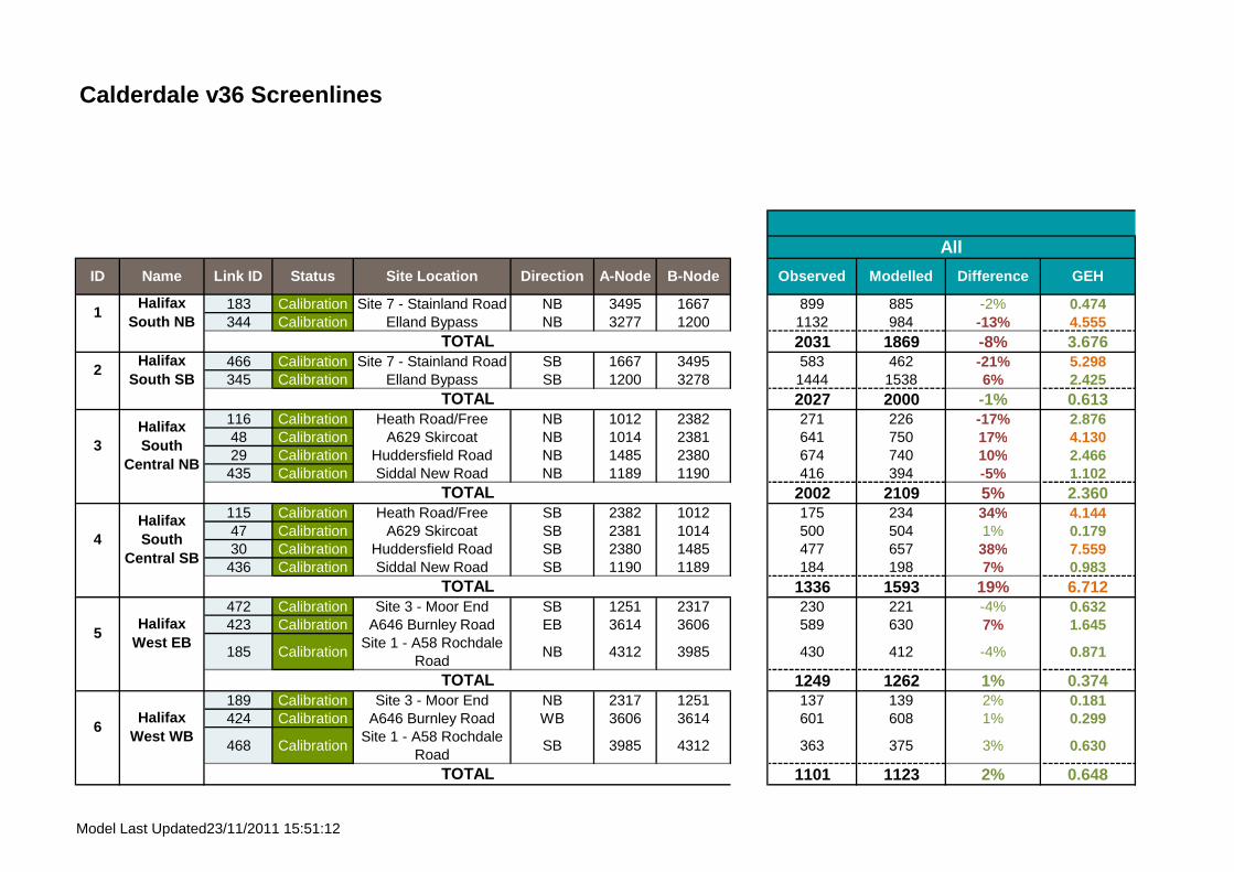
Calderdale v36 Screenlines
183 Calibration Site 7 - Stainland Road NB 3495 1667 899 885 -2% 0.474344 Calibration Elland Bypass NB 3277 1200 1132 984 -13% 4.555
SL1 2031 1869 -8% 3.676466 Calibration Site 7 - Stainland Road SB 1667 3495 583 462 -21% 5.298345 Calibration Elland Bypass SB 1200 3278 1444 1538 6% 2.425
SL2 2027 2000 -1% 0.613116 Calibration Heath Road/Free NB 1012 2382 271 226 -17% 2.87648 Calibration A629 Skircoat NB 1014 2381 641 750 17% 4.13029 Calibration Huddersfield Road NB 1485 2380 674 740 10% 2.466435 Calibration Siddal New Road NB 1189 1190 416 394 -5% 1.102
SL3 2002 2109 5% 2.360115 Calibration Heath Road/Free SB 2382 1012 175 234 34% 4.14447 Calibration A629 Skircoat SB 2381 1014 500 504 1% 0.17930 Calibration Huddersfield Road SB 2380 1485 477 657 38% 7.559436 Calibration Siddal New Road SB 1190 1189 184 198 7% 0.983
SL4 1336 1593 19% 6.712472 Calibration Site 3 - Moor End SB 1251 2317 230 221 -4% 0.632423 Calibration A646 Burnley Road EB 3614 3606 589 630 7% 1.645
185 CalibrationSite 1 - A58 Rochdale
RoadNB 4312 3985 430 412 -4% 0.871
SL5 1249 1262 1% 0.374189 Calibration Site 3 - Moor End NB 2317 1251 137 139 2% 0.181424 Calibration A646 Burnley Road WB 3606 3614 601 608 1% 0.299
468 CalibrationSite 1 - A58 Rochdale
RoadSB 3985 4312 363 375 3% 0.630
SL6 1101 1123 2% 0.648
Difference GEH
All
ID Name Link ID Status Site Location Direction A-Node B-Node Observed Modelled
1Halifax
South NBTOTAL
2Halifax
South SBTOTAL
3Halifax South
Central NB
TOTAL
4Halifax South
Central SB
5Halifax
West EB
TOTAL
6Halifax
West WB
TOTAL
TOTAL
Model Last Updated23/11/2011 15:51:12
ukmdj002
Text Box
AM

Calderdale v36 Screenlines
Difference GEH
All
ID Name Link ID Status Site Location Direction A-Node B-Node Observed Modelled
433 Calibration Pellon Lane EB 1575 1576 449 405 -10% 2.122313 Calibration Gibbet Street EB 1567 1565 282 258 -8% 1.456320 Calibration Hopwood Lane EB 1582 2723 153 196 28% 3.242
193 Calibration A58 Kings Cross Road NB 1584 1594 1014 966 -5% 1.518
SL7 1898 1825 -4% 1.686434 Calibration Pellon Lane WB 1576 1575 637 625 -2% 0.485314 Calibration Gibbet Street WB 1565 1567 55 54 -2% 0.163321 Calibration Hopwood Lane WB 2723 1582 117 156 34% 3.370
194 Calibration A58 Kings Cross Road SB 1594 1584 1015 1013 0% 0.062
SL8 1824 1848 1% 0.561349 Calibration Crag Lane SB 3966 1043 229 233 2% 0.283274 Calibration A647 Halifax Road SB 1243 1036 506 422 -17% 3.890
SL9 735 656 -11% 3.014348 Calibration Crag Lane NB 1043 3966 177 158 -11% 1.476273 Calibration A647 Halifax Road NB 1036 1243 221 228 3% 0.452
SL10 398 386 -3% 0.622188 Calibration Site 5 - Ovenden Road EB 1039 2400 893 907 2% 0.471318 Calibration Lee Bridge EB 1632 1631 377 404 7% 1.376186 Calibration Site 6 - Haley Hill SB 1523 1522 796 785 -1% 0.401393 Calibration Claremount Road SB 1203 2399 155 153 -1% 0.176
SL11 2221 2249 1% 0.589471 Calibration Site 5 - Ovenden Road WB 2400 1039 664 683 3% 0.739319 Calibration Lee Bridge WB 1631 1632 282 239 -15% 2.643469 Calibration Site 6 - Haley Hill NB 1522 1523 232 257 11% 1.603
TOTAL
11Halifax North
Central SB
TOTAL
12Halifax North
Central NB
TOTAL
TOTAL
8Halifax West
Central WB
TOTAL
9Halifax
North SB
10Halifax
North NB
7Halifax West
Central EB
Model Last Updated23/11/2011 15:51:12
ukmdj002
Text Box
AM

Calderdale v36 Screenlines
Difference GEH
All
ID Name Link ID Status Site Location Direction A-Node B-Node Observed Modelled
392 Calibration Claremount Road NB 2399 1203 230 176 -23% 3.777SL12 1408 1356 -4% 1.405
200 Calibration A58 West of WB 4238 1168 562 554 -1% 0.354332 Calibration Church Lane NB 3362 1007 397 520 31% 5.734
SL13 959 1073 12% 3.589199 Calibration A58 West of EB 1168 4238 619 493 -20% 5.331333 Calibration Church Lane SB 1007 3362 219 249 14% 1.991
SL14 838 743 -11% 3.388490 Calibration Victoria Road EB 3477 4036 495 277 -44% 11.109405 Calibration Jepson Lane SB 4408 3371 421 387 -8% 1.678
SL15 916 664 -28% 8.964491 Calibration Victoria Road WB 4036 3477 291 237 -19% 3.335404 Calibration Jepson Lane NB 3371 4408 380 370 -3% 0.518
SL16 671 607 -10% 2.540166 Calibration A6025 Park Road SB 3245 3358 503 433 -14% 3.219409 Calibration Lower Edge Road WB 3366 3367 308 272 -12% 2.137
164 Calibration B6114 Dewsbury Road WB 4104 3187 459 532 16% 3.290
SL17 1270 1237 -3% 0.926165 Calibration A6025 Park Road NB 3358 3245 578 658 14% 3.200408 Calibration Lower Edge Road EB 3367 3366 343 316 -8% 1.469
163 Calibration B6114 Dewsbury Road EB 3187 4104 411 426 4% 0.733
SL18 1332 1400 5% 1.8363 Calibration Crowtress Lane NB 3176 3175 365 401 10% 1.818
14Halifax East EB
TOTAL
15Elland
West EBTOTAL
16Elland
West WBTOTAL
17Elland East
WB
TOTAL
18Elland East
EB
TOTAL
Central NB
TOTAL
13Halifax
East WBTOTAL
19Brighouse
Model Last Updated23/11/2011 15:51:12
ukmdj002
Text Box
AM

Calderdale v36 Screenlines
Difference GEH
All
ID Name Link ID Status Site Location Direction A-Node B-Node Observed Modelled
461 CalibrationSite 12 - A641
Huddersfield RoadNB 3132 3125 888 852 -4% 1.233
SL19 1253 1252 0% 0.0224 Calibration Crowtrees Lane SB 3175 3176 338 349 3% 0.608
178 CalibrationSite 12 - A641
Huddersfield RoadSB 3125 3132 862 957 11% 3.142
SL20 1200 1306 9% 2.995462 Calibration Site 13 - A644 WB 3097 3095 500 428 -14% 3.340442 Calibration Coal Pit Lane WB 4095 4096 193 201 4% 0.576
241 CalibrationA643 Cleckheaton
RoadSB 3070 3068 332 344 4% 0.649
SL21 1025 973 -5% 1.643179 Calibration Site 13 - A644 EB 3095 3097 618 516 -16% 4.267441 Calibration Coal Pit Lane EB 4096 4095 76 117 54% 4.211
240 CalibrationA643 Cleckheaton
RoadNB 3068 3070 375 432 15% 2.828
SL22 1069 1066 0% 0.104249 Calibration A644 North of SB 3205 3169 453 460 2% 0.344
235 CalibrationA641 North of
BrighouseSB 3085 3086 685 712 4% 1.016
SL23 1138 1172 3% 1.006248 Calibration A644 North of NB 3169 3205 396 471 19% 3.600
234 CalibrationA641 North of
BirghouseNB 3086 3085 735 650 -12% 3.249
SL24 1131 1120 -1% 0.314192 Calibration Site 2 - A646 Burnley EB 1094 1095 747 768 3% 0.763
Brighouse North NB
Sowerby
TOTAL
19Brighouse South NB
TOTAL
20Brighouse South SB
21Brighouse East WB
TOTAL
22Brighouse
East EB
TOTAL
TOTAL
23Brighouse North SB
TOTAL
24
Model Last Updated23/11/2011 15:51:12
ukmdj002
Text Box
AM

Calderdale v36 Screenlines
Difference GEH
All
ID Name Link ID Status Site Location Direction A-Node B-Node Observed Modelled
195 Calibration A58 Calder Bridge NEB 1113 2275 825 753 -9% 2.570
211 Calibration A6026 Wakefield Road WB 1354 1355 328 237 -28% 5.391
SL25 1900 1758 -7% 3.316475 Calibration Site 2 - A646 Burnley WB 1095 1094 506 520 3% 0.639196 Calibration A58 Calder Bridge SWB 2275 1113 758 750 -1% 0.292
210 Calibration A6026 Wakefield Road EB 1355 1354 508 444 -13% 2.923
SL26 1772 1715 -3% 1.372364 Calibration Hopwood Lane EB 2332 2341 180 216 20% 2.539338 Calibration Parkinson Lane EB 1110 2340 226 149 -34% 5.602261 Calibration A646 Burnley Road EB 1428 1080 804 629 -22% 6.557
SL27 1210 994 -18% 6.523365 Calibration Hopwood Lane WB 2341 2332 136 147 8% 0.886339 Calibration Parkinson Lane WB 2340 1110 161 156 -3% 0.366262 Calibration A646 Burnley Road WB 1080 1428 414 371 -10% 2.151
SL28 711 674 -5% 1.39531 Calibration Freeschool Lane EB 2631 1012 379 424 12% 2.26433 Calibration Skircoat Moor Road EB 1390 1009 616 684 11% 2.669
SL29 995 1108 11% 3.49732 Calibration Freeschool Lane WB 1012 2631 243 283 16% 2.45734 Calibration Skircoat Moor Road WB 1009 1390 349 323 -7% 1.408
SL30 592 606 2% 0.573
25Sowerby
Bridge NB
TOTAL
Halifax South East
NBTOTAL
28Halifax
South East SB
TOTAL
29Saville
Park EBTOTAL
30Saville
Park WB
TOTAL
26Sowerby
Bridge SB
TOTAL
27
Model Last Updated23/11/2011 15:51:12
ukmdj002
Text Box
AM

Calderdale v36 Link Flows
IDCalibration / Validation
Area ID Site Location Dir Date Data Type Duplicate? Ref A-Node B-NodeAM
PeakInterpe
akType
3 Calibration 157 Crowtress Lane NB 12/07/2013 MCC No 3176-3175 3176 3175 Yes Yes 1-way 219 291 4.541 Yes Yes4 Calibration 157 Crowtrees Lane SB 12/07/2013 MCC No 3175-3176 3175 3176 Yes Yes 1-way 233 269 2.318 Yes Yes29 Calibration 163 Huddersfield Road NB 02/04/2014 - 16/04/2014 ATC No 1485-2380 1485 2380 Yes Yes 1-way 476 559 3.644 Yes Yes30 Calibration 163 Huddersfield Road SB 02/04/2014 - 16/04/2014 ATC No 2380-1485 2380 1485 Yes Yes 1-way 518 531 0.574 Yes Yes31 Calibration 164 Freeschool Lane EB 02/04/2014 - 16/04/2014 ATC No 2631-1012 2631 1012 Yes Yes 1-way 235 248 0.832 Yes Yes32 Calibration 164 Freeschool Lane WB 02/04/2014 - 16/04/2014 ATC No 1012-2631 1012 2631 Yes Yes 1-way 256 319 3.692 Yes Yes33 Calibration 165 Skircoat Moor Road EB 02/04/2014 - 16/04/2014 ATC No 1390-1009 1390 1009 Yes Yes 1-way 466 474 0.355 Yes Yes34 Calibration 165 Skircoat Moor Road WB 02/04/2014 - 16/04/2014 ATC No 1009-1390 1009 1390 Yes Yes 1-way 349 400 2.589 Yes Yes35 Calibration 166 Skircoat Green Road NB 02/04/2014 - 16/04/2014 ATC No 1481-1398 1481 1398 Yes Yes 1-way 171 115 4.615 Yes Yes36 Calibration 166 Skircoat Green Road SB 02/04/2014 - 16/04/2014 ATC No 1398-1481 1398 1481 Yes Yes 1-way 162 175 1.016 Yes Yes37 Calibration 167 A6026 Wakefield Road EB 02/04/2014 - 16/04/2014 ATC No 2266-1002 2266 1002 Yes Yes 1-way 417 421 0.167 Yes Yes38 Calibration 167 A6026 Wakefield Road WB 02/04/2014 - 16/04/2014 ATC No 1002-2266 1002 2266 Yes Yes 1-way 423 344 4.042 Yes Yes39 Validation 168 A629 Huddersifeld Road NB 03/04/2014 - 16/04/2014 ATC No 1462-1467 1462 1467 Yes Yes 1-way 1231 1199 0.918 Yes Yes40 Validation 168 A629 Huddersfield Road SB 03/04/2014 - 16/04/2014 ATC No 1467-1462 1467 1462 Yes Yes 1-way 1256 1183 2.102 Yes Yes43 Validation 169 A629 Skircoat road/Heath Road Junction NB 08/04/2014 MCC No 2772-1013 2772 1013 Yes Yes 1-way 511 618 4.483 Yes No44 Validation 169 A629 Skircoat Road/Heath Road Junction SB 08/04/2014 MCC No 1013-2772 1013 2772 Yes Yes 1-way 463 507 2.015 Yes Yes45 Validation 169 A629 Skircoat Road/Heath Road Junction NEB 08/04/2014 MCC No 1407-1013 1407 1013 Yes Yes 1-way 175 91 7.261 No Yes46 Validation 169 A629 Skircoat Road/Heath Road Junction SWB 08/04/2014 MCC No 1013-1407 1013 1407 Yes Yes 1-way 159 173 1.129 Yes Yes47 Calibration 170 A629 Skircoat Road/Free School Lane Junction SB 08/04/2014 MCC No 2381-1014 2381 1014 Yes Yes 1-way 470 481 0.499 Yes Yes48 Calibration 170 A629 Skircoat Road/Free School Lane Junction NB 08/04/2014 MCC No 1014-2381 1014 2381 Yes Yes 1-way 513 593 3.384 Yes Yes49 Calibration 170 A629 Skircoat Road/Free School Lane Junction WB 08/04/2014 MCC No 1485-1014 1485 1014 Yes Yes 1-way 186 157 2.269 Yes Yes50 Calibration 170 A629 Skircoat Road/Free School Lane Junction EB 08/04/2014 MCC No 1014-1485 1014 1485 Yes Yes 1-way 139 89 4.701 Yes Yes53 Calibration 170 A629 Skircoat Road/Free School Lane Junction EB 08/04/2014 MCC No 1616-1014 1616 1014 Yes Yes 1-way 168 65 9.494 No No54 Calibration 170 A629 Skircoat Road/Free School Lane Junction WB 08/04/2014 MCC No 1014-1616 1014 1616 Yes Yes 1-way 209 150 4.352 Yes Yes55 Calibration 171 A629 Skircoat Road/Huddersfield Road Junction SB 08/04/2014 MCC No 1014-1484 1014 1484 Yes Yes 1-way 490 457 1.517 Yes Yes56 Calibration 171 A629 Skircoat Road/Huddersfield Road Junction NB 08/04/2014 MCC No 1484-1014 1484 1014 Yes Yes 1-way 528 587 2.513 Yes Yes57 Calibration 171 A629 Skircoat Road/huddersfield Road Junction SWB 08/04/2014 MCC No 1485-1484 1485 1484 Yes Yes 1-way 315 374 3.179 Yes Yes58 Calibration 171 A629 Skircoat Road/Huddersfield Road Junction NEB 08/04/2014 MCC No 1484-1485 1484 1485 Yes Yes 1-way 319 470 7.624 No No67 Validation 173A629 Huddersfield Road/Coronation Road/Stafford Avenue SB 08/04/2014 MCC No 1400-2388 1400 2388 Yes Yes 1-way 802 841 1.384 Yes Yes68 Validation 173A629 Huddersfield Road/Coronation Road/Stafford Avenue NB 08/04/2014 MCC No 2388-1400 2388 1400 Yes Yes 1-way 796 904 3.690 Yes Yes69 Validation 173A629 Huddersfield Road/Coronation Road/Stafford Avenue WB 08/04/2014 MCC No 2608-2388 2608 2388 Yes Yes 1-way 37 79 5.547 No Yes70 Validation 173A629 Huddersfield Road/Coronation Road/Stafford Avenue EB 08/04/2014 MCC No 2388-2608 2388 2608 Yes Yes 1-way 40 70 4.141 Yes Yes71 Validation 173A629 Huddersfield Road/Coronation Road/Stafford Avenue NB 08/04/2014 MCC No 1199-2388 1199 2388 Yes Yes 1-way 793 866 2.541 Yes Yes72 Validation 173A629 Huddersfield Road/Coronation Road/Stafford Avenue SB 08/04/2014 MCC No 2388-1199 2388 1199 Yes Yes 1-way 796 812 0.587 Yes Yes79 Calibration 175 A629 Huddersfield Road/A646 Dry Clough Lane NB 08/04/2014 MCC No 2389-1008 2389 1008 Yes Yes 1-way 1018 1076 1.785 Yes Yes80 Calibration 175 A629 Huddersfield Road/A646 Dry Clough Lane SB 08/04/2014 MCC No 1008-2389 1008 2389 Yes Yes 1-way 1056 971 2.647 Yes Yes81 Calibration 175 A629 Huddersfield Road/A646 Dry Clough Lane EB 08/04/2014 MCC No 2387-1008 2387 1008 Yes Yes 1-way 397 411 0.703 Yes Yes82 Calibration 175 A629 Huddersfield Road/A646 Dry CLough Lane WB 08/04/2014 MCC No 1008-2387 1008 2387 Yes Yes 1-way 335 462 6.375 No No83 Validation 176 A629 Huddersfield Road/Dudwell Lane SB 08/04/2014 MCC No 2390-1483 2390 1483 Yes Yes 1-way 1062 971 2.832 Yes Yes84 Validation 176 A629 Huddersfield Road/Dudwell Lane NB 08/04/2014 MCC No 1483-2390 1483 2390 Yes Yes 1-way 1020 1076 1.717 Yes Yes85 Validation 176 A629 Huddersfield Road/Dudwell Lane SB 08/04/2014 MCC No 2391-1483 2391 1483 Yes Yes 1-way 1073 1067 0.168 Yes Yes86 Validation 176 A629 Huddersfield Road/Dudwell Lane NB 08/04/2014 MCC No 1483-2391 1483 2391 Yes Yes 1-way 1129 948 5.613 No No87 Calibration 176 A629 Huddersfield Road/Dudwell Lane EB 08/04/2014 MCC No 1477-1483 1477 1483 Yes Yes 1-way 192 76 10.041 No No88 Calibration 176 A629 Huddersfield Road/Dudwell Lane WB 08/04/2014 MCC No 1483-1477 1483 1477 Yes Yes 1-way 177 90 7.524 No Yes95 Validation 178 A646 Dry Clough Lane/Skircoat Green Road SB 08/04/2014 MCC No 1391-1009 1391 1009 Yes Yes 1-way 202 254 3.482 Yes Yes96 Validation 178 A646 Dry Clough Lane/Skircoat Green Road NB 08/04/2014 MCC No 1009-1391 1009 1391 Yes Yes 1-way 196 297 6.394 No No97 Validation 178 A646 Dry Clough Lane/Skircoat Green Road WB 08/04/2014 MCC No 2385-1009 2385 1009 Yes Yes 1-way 317 296 1.210 Yes Yes98 Validation 178 A646 Dry Clough Lane/Skirocat Green Road EB 08/04/2014 MCC No 1009-2385 1009 2385 Yes Yes 1-way 378 259 6.654 No No99 Calibration 178 A646 Dry Clough Lane/Skircoat Green Road NB 08/04/2014 MCC No 1396-1009 1396 1009 Yes Yes 1-way 299 246 3.200 Yes Yes100 Calibration 178 A646 Dry Clough Lane/Skircoat Green Road SB 08/04/2014 MCC No 1009-1396 1009 1396 Yes Yes 1-way 329 314 0.791 Yes Yes115 Calibration 182 Heath Road/Free School Lane SB 08/04/2014 MCC No 2382-1012 2382 1012 Yes Yes 1-way 161 173 0.984 Yes Yes116 Calibration 182 Heath Road/Free School Lane NB 08/04/2014 MCC No 1012-2382 1012 2382 Yes Yes 1-way 181 91 7.659 No Yes117 Calibration 182 Heath Road/Free School Lane WB 08/04/2014 MCC No 1616-1012 1616 1012 Yes Yes 1-way 210 150 4.432 Yes Yes118 Calibration 182 Heath Road/Free School Lane EB 08/04/2014 MCC No 1012-1616 1012 1616 Yes Yes 1-way 169 65 9.554 No No119 Calibration 182 Heath Road/Free School Lane NB 08/04/2014 MCC No 1401-1012 1401 1012 Yes Yes 1-way 189 145 3.409 Yes Yes120 Calibration 182 Heath Road/Free School Lane SB 08/04/2014 MCC No 1012-1401 1012 1401 Yes Yes 1-way 201 241 2.750 Yes Yes134 Validation 215 Slip onto M62 NB Jun-14 TRADS No 3427-3423 3427 3423 Yes Yes 1-way 720 931 7.346 No No135 Calibration M62 216 M62 at Junction 25 NB Jun-14 TRADS No 3413-3421 3413 3421 Yes Yes 1-way 3255 3474 3.764 Yes Yes136 Calibration M62 217 M62 at Junction 25 SB Jun-14 TRADS No 3422-3414 3422 3414 Yes Yes 1-way 3418 3504 1.469 Yes Yes137 Calibration M62 220 M62 approaching Clough Lane NB Jun-14 TRADS No 3406-3408 3406 3408 Yes Yes 1-way 3520 3888 6.039 No Yes138 Calibration M62 221 M62 after Clough Lane SB Jun-14 TRADS No 3409-3407 3409 3407 Yes Yes 1-way 3616 3623 0.114 Yes Yes143 Validation 227 Slip onto M62 at J23 SB Jun-14 TRADS No 3877-3537 3877 3537 Yes Yes 1-way 210 195 1.053 Yes Yes144 Validation 228 Slip off M62 at J23 NB Jun-14 TRADS No 3536-3858 3536 3858 Yes Yes 1-way 219 281 3.965 Yes Yes145 Calibration M62 229 M62 Next to Laund Road SB Jun-14 TRADS No 3398-3412 3398 3412 Yes Yes 1-way 3225 3062 2.890 Yes Yes
ALL VEHICLES
Observed Modelled GEH GEH Pass? Flow Pass?
Interpeak
Model Last Updated23/11/2011 15:51:12
ukmdj002
Text Box
IP

Calderdale v36 Link Flows
IDCalibration / Validation
Area ID Site Location Dir Date Data Type Duplicate? Ref A-Node B-NodeAM
PeakInterpe
akType
ALL VEHICLES
Observed Modelled GEH GEH Pass? Flow Pass?
Interpeak
146 Calibration M62 230 M62 Next to Laund Road NB Jun-14 TRADS No 3411-3397 3411 3397 Yes Yes 1-way 3134 3111 0.407 Yes Yes149 Calibration 235 Elland Riorges Link WB 12/06/2014 ANPR No 3333-3332 3333 3332 Yes Yes 1-way 235 240 0.331 Yes Yes150 Calibration 235 Elland Riorges Link EB 12/06/2014 ANPR No 3332-3333 3332 3333 Yes Yes 1-way 242 249 0.487 Yes Yes151 Calibration 233 A629 Calderdale Way NB 12/06/2014 ANPR No 3343-3344 3343 3344 Yes Yes 1-way 329 388 3.143 Yes Yes152 Calibration 233 A629 Calderdale Way SB 12/06/2014 ANPR No 3260-3286 3260 3286 Yes Yes 1-way 159 118 3.436 Yes Yes153 Calibration 231 Elland Riorges Link EB 12/06/2014 ANPR No 3254-3255 3254 3255 Yes Yes 1-way 368 234 7.724 No No154 Calibration 231 Elland Riorges Link WB 12/06/2014 ANPR No 3256-3254 3256 3254 Yes Yes 1-way 625 571 2.230 Yes Yes155 Calibration 232 A629 Calderdale Way SB 12/06/2014 ANPR No 3265-3266 3265 3266 Yes Yes 1-way 281 241 2.483 Yes Yes156 Calibration 232 A629 Calderdale Way NB 12/06/2014 ANPR No 3257-3264 3257 3264 Yes Yes 1-way 180 228 3.403 Yes Yes157 Calibration 234 Lowfields Way SWB 12/06/2014 ANPR No 3923-3331 3923 3331 Yes Yes 1-way 188 306 7.547 No No158 Calibration 234 Lowfields Way NEB 12/06/2014 ANPR No 3331-3923 3331 3923 Yes Yes 1-way 194 240 3.170 Yes Yes159 Validation 236 Bradford Old Road NB Jun-14 ATC No 1443-1442 1443 1442 Yes Yes 1-way 24 13 2.587 Yes Yes160 Validation 236 Bradford Old Road SB Jun-14 ATC No 1442-1443 1442 1443 Yes Yes 1-way 29 21 1.685 Yes Yes163 Calibration 238 B6114 Dewsbury Road EB Jun-14 ATC No 3187-4104 3187 4104 Yes Yes 1-way 229 239 0.639 Yes Yes164 Calibration 238 B6114 Dewsbury Road WB Jun-14 ATC No 4104-3187 4104 3187 Yes Yes 1-way 241 320 4.697 Yes Yes165 Calibration 239 A6025 Park Road NB Jun-14 ATC No 3358-3245 3358 3245 Yes Yes 1-way 408 431 1.097 Yes Yes166 Calibration 239 A6025 Park Road SB Jun-14 ATC No 3245-3358 3245 3358 Yes Yes 1-way 403 411 0.393 Yes Yes167 Validation 240 A646 Skircoat Moor Road EB Jun-14 ATC No 1389-1062 1389 1062 Yes Yes 1-way 380 313 3.601 Yes Yes168 Validation 240 A646 Skircoat Moor Road WB Jun-14 ATC No 1062-1389 1062 1389 Yes Yes 1-way 311 233 4.768 Yes Yes169 Calibration 242 B6113 Saddleworth Road EB Jun-14 ATC No 3517-3527 3517 3527 Yes Yes 1-way 154 48 10.508 No No170 Calibration 242 B6113 Saddleworth Road WB Jun-14 ATC No 3527-3517 3527 3517 Yes Yes 1-way 162 19 15.045 No No171 Calibration 243 A629 Huddersfield Road NB Jun-14 ATC No 3300-3296 3300 3296 Yes Yes 1-way 883 942 1.945 Yes Yes173 Validation 245 Calderdale Way at bus stop SB Jun-14 ATC No 3286-3292 3286 3292 Yes Yes 1-way 753 660 3.514 Yes Yes174 Calibration RSI Out 246 Site 16 - Whitehall Road EB 11/06/2014 MCC/RSI No 3473-3482 3473 3482 Yes Yes 1-way 566 575 0.384 Yes Yes175 Calibration RSI Out 247 Site 17 - Bradford Road NB 11/06/2014 ATC/RSI No 3944-3195 3944 3195 Yes Yes 1-way 457 505 2.209 Yes Yes176 Calibration RSI Out 248 Site 15 - Birkby Lane EB 18/06/2014 MCC/RSI No 3082-3073 3082 3073 Yes Yes 1-way 172 211 2.887 Yes Yes177 Calibration RSI Out 249 Site14 - Walton Lane NB 18/06/2014 MCC/RSI No 3071-3072 3071 3072 Yes Yes 1-way 210 224 0.931 Yes Yes178 Calibration RSI Out 250 Site 12 - A641 Huddersfield Road SB 10/06/2014 MCC/RSI No 3125-3132 3125 3132 Yes Yes 1-way 519 442 3.496 Yes Yes179 Calibration RSI Out 251 Site 13 - A644 Wakefield Road EB 18/06/2014 MCC/RSI No 3095-3097 3095 3097 Yes Yes 1-way 513 577 2.741 Yes Yes180 Calibration RSI Out 252 Site 11 - Clough Lane (A6107) EB 10/06/2014 MCC/RSI No 3137-3135 3137 3135 Yes Yes 1-way 444 346 4.943 Yes Yes181 Calibration RSI In 253 Site 10 - New Hey Road NEB 10/06/2014 MCC/RSI No 3173-4291 3173 4291 Yes Yes 1-way 566 576 0.440 Yes Yes182 Calibration RSI In 254 Site 9 - New Road SB 12/06/2014 ATC/RSI No 3888-3886 3888 3886 Yes Yes 1-way 87 107 2.053 Yes Yes183 Calibration RSI In 255 Site 7 - Stainland Road NB 12/06/2014 MCC/RSI No 3495-1667 3495 1667 Yes Yes 1-way 503 515 0.528 Yes Yes185 Calibration RSI In 257 Site 1 - A58 Rochdale Road EB 17/06/2014 MCC/RSI No 4312-3985 4312 3985 Yes Yes 1-way 280 325 2.616 Yes Yes186 Calibration RSI In 258 Site 6 - Haley Hill SEB 19/06/2014 MCC/RSI No 1523-1522 1523 1522 Yes Yes 1-way 461 415 2.194 Yes Yes187 Calibration RSI In 259 Site 4 - Shroggs Road SB 17/06/2014 MCC/RSI No 1127-1126 1127 1126 Yes Yes 1-way 242 178 4.372 Yes Yes188 Calibration RSI In 260 Site 5 - Ovenden Road SB 19/06/2014 MCC/RSI No 1039-2400 1039 2400 Yes Yes 1-way 623 614 0.360 Yes Yes189 Calibration RSI Out 261 Site 3 - Moor End Road NWB 17/06/2014 ATC/RSI No 2317-1251 2317 1251 Yes Yes 1-way 144 113 2.703 Yes Yes190 Calibration RSI In 262 Site 18 - Wade House Road NEB 24/06/2014 ATC/RSI No 3235-4404 3235 4404 Yes Yes 1-way 596 545 2.138 Yes Yes191 Calibration RSI In 263 Site 19 - A644 Brighouse & Denholme Gate Road SB 24/06/2014 ATC/RSI No 1238-1452 1238 1452 Yes Yes 1-way 421 356 3.281 Yes Yes192 Calibration RSI In 264 Site 2 - A646 Burnley Road EB 17/06/2014 MCC/RSI No 1094-1095 1094 1095 Yes Yes 1-way 538 478 2.698 Yes Yes193 Calibration 1 A58 Kings Cross Road NB 12-06-2013 to 20-06-2013 ATC No 1584-1594 1584 1594 Yes Yes 1-way 823 787 1.284 Yes Yes194 Calibration 1 A58 Kings Cross Road SB 12-06-2013 to 20-06-2013 ATC No 1594-1584 1594 1584 Yes Yes 1-way 832 859 0.927 Yes Yes195 Calibration 2 A58 Calder Bridge NEB 20-06-2013 to 01-07-2013 ATC No 1113-2275 1113 2275 Yes Yes 1-way 680 701 0.799 Yes Yes196 Calibration 2 A58 Calder Bridge SWB 20-06-2013 to 01-07-2013 ATC No 2275-1113 2275 1113 Yes Yes 1-way 708 682 0.960 Yes Yes197 Calibration 3 A58 Rochdale Road EB 20-06-2013 to 01-07-2013 ATC No 8099-1065 8099 1065 Yes Yes 1-way 544 638 3.863 Yes Yes198 Calibration 3 A58 Rochdale Road WB 20-06-2013 to 01-07-2013 ATC No 1065-8099 1065 8099 Yes Yes 1-way 499 574 3.266 Yes Yes199 Calibration 4 A58 West of Hipperholme EB 10-07-2013 to 26-07-2013 ATC No 1168-4238 1168 4238 Yes Yes 1-way 648 609 1.560 Yes Yes200 Calibration 4 A58 West of Hipperholme WB 10-07-2013 to 26-07-2013 ATC No 4238-1168 4238 1168 Yes Yes 1-way 594 521 3.110 Yes Yes206 Validation 8 A6025 Park Road EB 05-07-2013 to 15-07-2013 ATC No 3244-3243 3244 3243 Yes Yes 1-way 427 413 0.720 Yes Yes207 Validation 8 A6025 Park Road WB 05-07-2013 to 15-07-2013 ATC No 3243-3244 3243 3244 Yes Yes 1-way 423 392 1.529 Yes Yes208 Validation 9 A6026 Wakefield Road EB 19-06-2013 to 01-07-2013 ATC No 2272-1092 2272 1092 Yes Yes 1-way 408 362 2.349 Yes Yes209 Validation 9 A6026 Wakefield Road WB 19-06-2013 to 01-07-2013 ATC No 1092-2272 1092 2272 Yes Yes 1-way 427 424 0.177 Yes Yes210 Calibration 10 A6026 Wakefield Road EB 20-06-2013 to 01-07-2013 ATC No 1355-1354 1355 1354 Yes Yes 1-way 329 300 1.621 Yes Yes211 Calibration 10 A6026 Wakefield Road WB 20-06-2013 to 01-07-2013 ATC No 1354-1355 1354 1355 Yes Yes 1-way 318 280 2.203 Yes Yes212 Calibration 11 A6033 South of Todmorden NB 22-07-2013 to 30-07-2013 ATC No 4251-4927 4251 4927 Yes Yes 1-way 272 205 4.326 Yes Yes213 Calibration 11 A6033 South of Todmorden SB 22-07-2013 to 30-07-2013 ATC No 4927-4251 4927 4251 Yes Yes 1-way 270 135 9.492 No No214 Validation 12 A6033 Keighley Road Peckett Well NB 07-02-2013 to 18-02-2013 ATC No 3753-3754 3753 3754 Yes Yes 1-way 105 75 3.191 Yes Yes215 Validation 12 A6033 Keighley Road Peckett Well SB 07-02-2013 to 18-02-2013 ATC No 3754-3753 3754 3753 Yes Yes 1-way 99 89 0.949 Yes Yes218 Calibration 14 A6036 North of Northowram NB 10-07-2013 to 18-07-2013 ATC No 1167-1234 1167 1234 Yes Yes 1-way 427 507 3.708 Yes Yes219 Calibration 14 A6036 North of Northowram SB 10-07-2013 to 18-07-2013 ATC No 1234-1167 1234 1167 Yes Yes 1-way 396 431 1.749 Yes Yes222 Calibration 16 A6139 Tuel Lane NB 20-06-2013 to 01-07-2013 ATC No 1356-1112 1356 1112 Yes Yes 1-way 345 463 5.884 No No223 Calibration 16 A6139 Tuel Lane SB 20-06-2013 to 01-07-2013 ATC No 1112-1356 1112 1356 Yes Yes 1-way 380 328 2.763 Yes Yes224 Calibration 17 A629 Halifax Causeway Foot NB 11-04-2013 to 22-04-2013 ATC No 4016-1247 4016 1247 Yes Yes 1-way 281 289 0.432 Yes Yes
Model Last Updated23/11/2011 15:51:12
ukmdj002
Text Box
IP

Calderdale v36 Link Flows
IDCalibration / Validation
Area ID Site Location Dir Date Data Type Duplicate? Ref A-Node B-NodeAM
PeakInterpe
akType
ALL VEHICLES
Observed Modelled GEH GEH Pass? Flow Pass?
Interpeak
225 Calibration 17 A629 Halifax Causeway Foot SB 11-04-2013 to 22-04-2013 ATC No 1247-4016 1247 4016 Yes Yes 1-way 289 259 1.796 Yes Yes230 Calibration 21 A641 Huddersfield Road NB 08-07-2013 to 16-07-2013 ATC No 3930-3946 3930 3946 Yes Yes 1-way 609 500 4.633 Yes No231 Calibration 21 A641 Huddersfield Road SB 08-07-2013 to 16-07-2013 ATC No 3946-3930 3946 3930 Yes Yes 1-way 650 510 5.780 No No234 Calibration 23 A641 North of Birghouse NB 05-07-2013 to 23-07-2013 ATC No 3086-3085 3086 3085 Yes Yes 1-way 560 550 0.413 Yes Yes235 Calibration 23 A641 North of Brighouse SB 05-07-2013 to 23-07-2013 ATC No 3085-3086 3085 3086 Yes Yes 1-way 561 574 0.552 Yes Yes236 Validation 24 A643 North of Anchor Bridge NB 08-07-2013 to 16-07-2013 ATC No 3039-3921 3039 3921 Yes Yes 1-way 560 862 11.311 No No237 Validation 24 A643 North of Anchor Bridge SB 08-07-2013 to 16-07-2013 ATC No 3921-3039 3921 3039 Yes Yes 1-way 534 641 4.412 Yes No240 Calibration 26 A643 Cleckheaton Road NB 05-07-2013 to 15-07-2013 ATC No 3068-3070 3068 3070 Yes Yes 1-way 240 223 1.106 Yes Yes241 Calibration 26 A643 Cleckheaton Road SB 05-07-2013 to 15-07-2013 ATC No 3070-3068 3070 3068 Yes Yes 1-way 221 218 0.240 Yes Yes244 Validation 28 A644 North of Hipperholme NB 10-07-2013 to 18-07-2013 ATC No 3229-3225 3229 3225 Yes Yes 1-way 402 333 3.597 Yes Yes245 Validation 28 A644 North of Hipperholme SB 10-07-2013 to 18-07-2013 ATC No 3225-3229 3225 3229 Yes Yes 1-way 422 419 0.118 Yes Yes246 Calibration 29 A644 Commercial Street EB 02-07-2014 to 11-07-2014 ATC No 3042-3942 3042 3942 Yes Yes 1-way 802 814 0.433 Yes Yes247 Calibration 29 A644 Commercial treet WB 02-07-2014 to 11-07-2014 ATC No 3942-3042 3942 3042 Yes Yes 1-way 714 591 4.826 Yes No248 Calibration 30 A644 North of Brighouse NB 05-07-2013 to 15-07-2013 ATC No 3169-3205 3169 3205 Yes Yes 1-way 396 395 0.018 Yes Yes249 Calibration 30 A644 North of Brighouse SB 05-07-2013 to 15-07-2013 ATC No 3205-3169 3205 3169 Yes Yes 1-way 409 399 0.459 Yes Yes250 Calibration 31 A644 Wakefield Road EB 17-07-2013 to 30-07-2013 ATC No 4092-4093 4092 4093 Yes Yes 1-way 827 850 0.811 Yes Yes251 Calibration 31 A644 Wakefield Road WB 17-07-2013 to 30-07-2013 ATC No 4093-4092 4093 4092 Yes Yes 1-way 881 792 3.062 Yes Yes254 Validation 33 A646 West of Todmorden NB 06-08-2014 to 15-08-2014 ATC No 3684-3687 3684 3687 Yes Yes 1-way 195 151 3.291 Yes Yes255 Validation 33 A644 West of Todmorden SB 06-08-2014 to 15-08-2014 ATC No 3687-3684 3687 3684 Yes Yes 1-way 179 154 1.917 Yes Yes259 Validation 36 Skircoat Moor Road NB 12-06-2013 to 20-06-2013 ATC No 2294-1064 2294 1064 Yes Yes 1-way 448 540 4.151 Yes Yes260 Validation 36 Skircoat Moor Road SB 12-06-2013 to 20-06-2013 ATC No 1064-2294 1064 2294 Yes Yes 1-way 530 353 8.442 No No261 Calibration 37 A646 Burnley Road EB 12-06-2013 to 20-06-2013 ATC No 1428-1080 1428 1080 Yes Yes 1-way 473 333 6.968 No No262 Calibration 37 A646 Burnley Road WB 12-06-2013 to 20-06-2013 ATC No 1080-1428 1080 1428 Yes Yes 1-way 436 316 6.201 No No265 Calibration 39 A646 Halifax Road EB 01-02-2013 to 07-02-2013 ATC No 3662-3659 3662 3659 Yes Yes 1-way 360 425 3.251 Yes Yes266 Calibration 39 A646 Halifax Road WB 01-02-2013 to 07-02-2013 ATC No 3659-3662 3659 3662 Yes Yes 1-way 353 361 0.390 Yes Yes267 Calibration 40 A646 Halifax Road EB 01-02-2013 to 07-02-2013 ATC No 3667-3666 3667 3666 Yes Yes 1-way 426 391 1.710 Yes Yes268 Calibration 40 A646 Halifax Road WB 01-02-2013 to 07-02-2013 ATC No 3666-3667 3666 3667 Yes Yes 1-way 426 345 4.130 Yes Yes269 Calibration 41 A646 Burnley Road EB 13-11-2013 to 22-11-2013 ATC No 3618-3617 3618 3617 Yes Yes 1-way 544 611 2.789 Yes Yes270 Calibration 41 A646 Burnley Road WB 13-11-2013 to 22-11-2013 ATC No 3617-3618 3617 3618 Yes Yes 1-way 539 527 0.517 Yes Yes273 Calibration 43 A647 Halifax Road NB 27-06-2013 to 05-07-2013 ATC No 1036-1243 1036 1243 Yes Yes 1-way 252 200 3.460 Yes Yes274 Calibration 43 A647 Halifax Road SB 27-06-2013 to 05-07-2013 ATC No 1243-1036 1243 1036 Yes Yes 1-way 268 198 4.605 Yes Yes279 Validation 46 A649 Lightcliffe EB 15-07-2013 to 23-07-2013 ATC No 3218-3221 3218 3221 Yes Yes 1-way 257 326 4.087 Yes Yes280 Validation 46 A649 Lightcliffe WB 15-07-2013 to 23-07-2013 ATC No 3221-3218 3221 3218 Yes Yes 1-way 250 218 2.076 Yes Yes283 Calibration 48 A672 SW of Ripponden EB 26-07-2013 to 05-08-2013 ATC No 3573-3574 3573 3574 Yes Yes 1-way 148 206 4.354 Yes Yes284 Calibration 48 A672 SW of Ripponden WB 26-07-2013 to 05-08-2013 ATC No 3574-3573 3574 3573 Yes Yes 1-way 143 154 0.933 Yes Yes295 Calibration 54 B6112 Stainland Road EB 05-11-2013 to 13-11-2013 ATC No 3502-4373 3502 4373 Yes Yes 1-way 135 249 8.235 No No296 Calibration 54 B6112 Stainland Road WB 05-11-2013 to 13-11-2013 ATC No 4373-3502 4373 3502 Yes Yes 1-way 186 359 10.476 No No299 Calibration 56 B6112 Stainland Road NB 05-11-2013 to 13-11-2013 ATC No 3501-3500 3501 3500 Yes Yes 1-way 135 168 2.679 Yes Yes300 Calibration 56 B6112 Stainland Road SB 05-11-2013 to 13-11-2013 ATC No 3500-3501 3500 3501 Yes Yes 1-way 145 262 8.203 No No303 Validation 58 B6114 Ringstone Edge Moor NB 29-07-2013 to 06-08-2013 ATC No 3732-3731 3732 3731 Yes Yes 1-way 39 52 1.874 Yes Yes304 Validation 58 B6114 Ringstone Edge Moor SB 29-07-2013 to 06-08-2013 ATC No 3731-3732 3731 3732 Yes Yes 1-way 36 34 0.337 Yes Yes309 Calibration 62 Bradshaw Lane NB 12-03-2013 to 21-03-2013 ATC No 7104-1318 7104 1318 Yes Yes 1-way 92 134 3.937 Yes Yes310 Calibration 62 Bradshaw Lane SB 12-03-2013 to 21-03-2013 ATC No 1318-7104 1318 7104 Yes Yes 1-way 100 148 4.300 Yes Yes311 Validation 63 Long Causeway EB 22-07-2013 to 30-07-2013 ATC No 3846-3845 3846 3845 Yes Yes 1-way 31 52 3.340 Yes Yes312 Validation 63 Long Causeway WB 22-07-2013 to 30-07-2013 ATC No 3845-3846 3845 3846 Yes Yes 1-way 29 36 1.367 Yes Yes313 Calibration 64 Gibbet Street EB 02-06-2014 to 17-06-2014 ATC No 1567-1565 1567 1565 Yes Yes 1-way 281 303 1.332 Yes Yes314 Calibration 64 Gibbet Street WB 02-06-2014 to 17-06-2014 ATC No 1565-1567 1565 1567 Yes Yes 1-way 63 98 3.917 Yes Yes315 Calibration 65 Slip onto Burdock Way NB 03-06-2013 to 12-06-2013 ATC No 4422-1556 4422 1556 Yes Yes 1-way 493 615 5.200 No No316 Validation 66 Windy Bank Lane EB 05-07-2013 to 15-07-2013 ATC No 4008-1241 4008 1241 Yes Yes 1-way 85 180 8.173 No Yes317 Validation 66 Windy Bank Lane WB 05-07-2013 to 15-07-2013 ATC No 1241-4008 1241 4008 Yes Yes 1-way 82 181 8.645 No Yes318 Calibration 67 Lee Bridge EB 17-06-2014 to 25-06-2014 ATC No 1632-1631 1632 1631 Yes Yes 1-way 237 247 0.670 Yes Yes319 Calibration 67 Lee Bridge WB 17-06-2014 to 25-06-2014 ATC No 1631-1632 1631 1632 Yes Yes 1-way 334 317 0.979 Yes Yes320 Calibration 68 Hopwood Lane EB 02-06-2014 to 25-06-2014 ATC No 1582-2723 1582 2723 Yes Yes 1-way 143 152 0.739 Yes Yes321 Calibration 68 Hopwood Lane WB 02-06-2014 to 25-06-2014 ATC No 2723-1582 2723 1582 Yes Yes 1-way 134 167 2.668 Yes Yes324 Validation 70 Swires Road EB 03-06-2013 to 12-06-2013 ATC No 1058-1408 1058 1408 Yes Yes 1-way 166 175 0.624 Yes Yes325 Validation 70 Swires Road WB 03-06-2013 to 12-06-2013 ATC No 1408-1058 1408 1058 Yes Yes 1-way 225 371 8.437 No No328 Validation 72 Haugh Shaw Road EB 02-06-2014 to 17-06-2014 ATC No 1409-2366 1409 2366 Yes Yes 1-way 133 368 14.891 No No329 Validation 72 Haugh Shaw Road WB 02-06-2014 to 17-06-2014 ATC No 2366-1409 2366 1409 Yes Yes 1-way 237 291 3.289 Yes Yes332 Calibration 74 Church Lane NB 05-07-2013 to 15-07-2013 ATC No 3362-1007 3362 1007 Yes Yes 1-way 159 206 3.467 Yes Yes333 Calibration 74 Church Lane SB 05-07-2013 to 15-07-2013 ATC No 1007-3362 1007 3362 Yes Yes 1-way 145 175 2.351 Yes Yes334 Calibration 76 B6138 Cragg Vale NB 06-08-2014 to 15-08-2014 ATC No 3647-3612 3647 3612 Yes Yes 1-way 101 90 1.102 Yes Yes335 Calibration 76 B6138 Cragg Vale SB 06-08-2014 to 15-08-2014 ATC No 3612-3647 3612 3647 Yes Yes 1-way 107 86 2.175 Yes Yes336 Calibration 77 Mixenden Road NB 20-05-2014 to 23-05-2014 ATC No 4423-3969 4423 3969 Yes Yes 1-way 85 154 6.347 No Yes337 Calibration 77 Mixenden Road SB 20-05-2014 to 23-05-2014 ATC No 3969-4423 3969 4423 Yes Yes 1-way 71 144 7.058 No Yes
Model Last Updated23/11/2011 15:51:12
ukmdj002
Text Box
IP

Calderdale v36 Link Flows
IDCalibration / Validation
Area ID Site Location Dir Date Data Type Duplicate? Ref A-Node B-NodeAM
PeakInterpe
akType
ALL VEHICLES
Observed Modelled GEH GEH Pass? Flow Pass?
Interpeak
338 Calibration 78 Parkinson Lane EB 02-06-2014 to 17-06-2014 ATC No 1110-2340 1110 2340 Yes Yes 1-way 147 127 1.704 Yes Yes339 Calibration 78 Parkinson Lane WB 02-06-2014 to 17-06-2014 ATC No 2340-1110 2340 1110 Yes Yes 1-way 153 168 1.175 Yes Yes340 Validation 80 Stanley Road NB 17-04-2013 to 25-04-2013 ATC No 2709-4319 2709 4319 Yes Yes 1-way 69 24 6.478 No Yes341 Validation 80 Stanley Road SB 17-04-2013 to 25-04-2013 ATC No 4319-2709 4319 2709 Yes Yes 1-way 63 56 0.835 Yes Yes342 Calibration 82 B6113 Rochdale Road EB 06-08-2014 to 14-08-2014 ATC No 3524-3523 3524 3523 Yes Yes 1-way 127 109 1.659 Yes Yes343 Calibration 82 B6113 Rochdale Road WB 06-08-2014 to 14-08-2014 ATC No 3523-3524 3523 3524 Yes Yes 1-way 79 98 2.054 Yes Yes344 Calibration 83 Elland Bypass NB 20-06-2013 to 05-07-2013 ATC No 3277-1200 3277 1200 Yes Yes 1-way 1094 1016 2.404 Yes Yes345 Calibration 83 Elland Bypass SB 20-06-2013 to 05-07-2013 ATC No 1200-3278 1200 3278 Yes Yes 1-way 1158 1082 2.262 Yes Yes348 Calibration 86 Crag Lane NB 12-05-2014 to 20-05-2014 ATC No 1043-3966 1043 3966 Yes Yes 1-way 143 167 1.868 Yes Yes349 Calibration 86 Crag Lane SB 12-05-2014 to 20-05-2014 ATC No 3966-1043 3966 1043 Yes Yes 1-way 154 159 0.435 Yes Yes350 Calibration 87 A641 Bradford Road NB 02-09-2014 to 10-09-2014 ATC No 3158-3156 3158 3156 Yes Yes 1-way 554 512 1.825 Yes Yes351 Calibration 87 A641 Bradfrod Road SB 02-09-2014 to 10-09-2014 ATC No 3156-3158 3156 3158 Yes Yes 1-way 546 519 1.159 Yes Yes360 Validation 96 Midgley Road NB 04-11-2013 to 13-11-2013 ATC No 4388-4392 4388 4392 Yes Yes 1-way 63 83 2.374 Yes Yes361 Validation 96 Midgley Road SB 04-11-2013 to 13-11-2013 ATC No 4392-4388 4392 4388 Yes Yes 1-way 54 135 8.337 No Yes362 Calibration 97 Hopwood Lane EB 04-11-2013 to 13-11-2013 ATC No 1124-2336 1124 2336 Yes Yes 1-way 64 29 5.212 No Yes363 Calibration 97 Hopwood Lane WB 04-11-2013 to 13-11-2013 ATC No 2336-1124 2336 1124 Yes Yes 1-way 80 39 5.352 No Yes364 Calibration 98 Hopwood Lane EB 04-11-2013 to 13-11-2013 ATC No 2332-2341 2332 2341 Yes Yes 1-way 113 82 3.103 Yes Yes365 Calibration 98 Hopwood Lane WB 04-11-2013 to 13-11-2013 ATC No 2341-2332 2341 2332 Yes Yes 1-way 131 91 3.849 Yes Yes366 Calibration 100 High Street EB 04-11-2013 to 13-11-2013 ATC No 3891-3535 3891 3535 Yes Yes 1-way 51 193 12.818 No No367 Calibration 100 High Street WB 04-11-2013 to 13-11-2013 ATC No 3535-3891 3535 3891 Yes Yes 1-way 50 171 11.467 No No368 Validation 101 Broad Carr Lane EB 05-11-2013 to 13-11-2013 ATC No 3504-3503 3504 3503 Yes Yes 1-way 106 81 2.521 Yes Yes369 Validation 101 Broad Carr Lane WB 05-11-2013 to 13-11-2013 ATC No 3503-3504 3503 3504 Yes Yes 1-way 106 98 0.864 Yes Yes372 Calibration 104 Albert Road EB 25-11-2013 to 03-12-2013 ATC No 2303-1071 2303 1071 Yes Yes 1-way 126 104 2.100 Yes Yes373 Calibration 104 Albert Road WB 25-11-2013 to 03-12-2013 ATC No 1071-2303 1071 2303 Yes Yes 1-way 144 126 1.530 Yes Yes378 Validation 107 Gibbet Street EB 25-11-2013 to 03-12-2013 ATC No 2306-2307 2306 2307 Yes Yes 1-way 205 230 1.705 Yes Yes379 Validation 107 Gibbet Street WB 25-11-2013 to 03-12-2013 ATC No 2307-2306 2307 2306 Yes Yes 1-way 210 89 9.925 No No380 Calibration 108 Highroad Well Lane EB 25-11-2013 to 03-12-2013 ATC No 1375-2316 1375 2316 Yes Yes 1-way 55 39 2.380 Yes Yes381 Calibration 108 Highroad Well Lane WB 25-11-2013 to 03-12-2013 ATC No 2316-1375 2316 1375 Yes Yes 1-way 61 6 9.550 No Yes384 Validation 110 Pellon New Road EB 28-11-2013 to 06-12-2013 ATC No 1121-2402 1121 2402 Yes Yes 1-way 262 235 1.722 Yes Yes385 Validation 110 Pellon New Road WB 28-11-2013 to 06-12-2013 ATC No 2402-1121 2402 1121 Yes Yes 1-way 241 272 1.910 Yes Yes386 Calibration 111 Roils Head Road EB 25-11-2013 to 03-12-2013 ATC No 1133-2295 1133 2295 Yes Yes 1-way 70 44 3.464 Yes Yes387 Calibration 111 Roils Head Road WB 25-11-2013 to 03-12-2013 ATC No 2295-1133 2295 1133 Yes Yes 1-way 73 23 7.168 No Yes392 Calibration 116 Claremount Road NB 07-11-2013 to 15-11-2013 ATC No 2399-1203 2399 1203 Yes Yes 1-way 100 90 1.031 Yes Yes393 Calibration 116 Claremount Road SB 07-11-2013 to 15-11-2013 ATC No 1203-2399 1203 2399 Yes Yes 1-way 85 91 0.708 Yes Yes402 Validation 122 Hullenedge Road EB 25-11-2013 to 03-12-2013 ATC No 3486-3372 3486 3372 Yes Yes 1-way 26 92 8.572 No Yes403 Validation 122 Hullenedge Road WB 25-11-2013 to 03-12-2013 ATC No 3372-3486 3372 3486 Yes Yes 1-way 64 115 5.466 No Yes404 Calibration 123 Jepson Lane NB 13-11-2013 to 22-11-2013 ATC No 3371-4408 3371 4408 Yes Yes 1-way 265 260 0.320 Yes Yes405 Calibration 123 Jepson Lane SB 13-11-2013 to 22-11-2013 ATC No 4408-3371 4408 3371 Yes Yes 1-way 300 260 2.395 Yes Yes406 Validation 124 Elland Lane EB 14-11-2013 to 22-11-2013 ATC No 3334-3335 3334 3335 Yes Yes 1-way 240 224 1.071 Yes Yes407 Validation 124 Elland Lane WB 14-11-2013 to 22-11-2013 ATC No 3335-3334 3335 3334 Yes Yes 1-way 220 179 2.879 Yes Yes408 Calibration 125 Lower Edge Road EB 14-11-2013 to 22-11-2013 ATC No 3367-3366 3367 3366 Yes Yes 1-way 188 140 3.745 Yes Yes409 Calibration 125 Lower Edge Road WB 14-11-2013 to 22-11-2013 ATC No 3366-3367 3366 3367 Yes Yes 1-way 171 153 1.361 Yes Yes410 Calibration 126 A58 New Bank WB 01-06-2014 to 30-06-2014 ATC No 1033-1515 1033 1515 Yes Yes 1-way 693 1093 13.367 No No411 Calibration 126 A58 New Bank EB 01-06-2014 to 30-06-2014 ATC No 1514-1033 1514 1033 Yes Yes 1-way 1243 1337 2.602 Yes Yes412 Calibration 127 A58 Kings Cross Road EB 01-06-2014 to 30-06-2014 ATC No 1431-2365 1431 2365 Yes Yes 1-way 708 692 0.617 Yes Yes413 Calibration 127 A58 Kings Cross Road WB 01-06-2014 to 30-06-2014 ATC No 2365-1431 2365 1431 Yes Yes 1-way 554 673 4.801 Yes No414 Calibration 128 A58 Rochdale Road EB 08-01-2014 to 16-01-2014 ATC No 3588-3587 3588 3587 Yes Yes 1-way 106 108 0.225 Yes Yes415 Calibration 128 A58 Rochdale Road WB 08-01-2014 to 16-01-2014 ATC No 3587-3588 3587 3588 Yes Yes 1-way 108 173 5.434 No Yes418 Validation 130 A629 Skircoat Road NB 01-06-2014 to 30-06-2014 ATC No 2369-1013 2369 1013 Yes Yes 1-way 598 660 2.451 Yes Yes419 Validation 130 A629 Skircoat Road SB 01-06-2014 to 30-06-2014 ATC No 1013-2369 1013 2369 Yes Yes 1-way 642 689 1.799 Yes Yes420 Calibration 131 A646 Market Street EB 08-01-2014 to 16-01-2014 ATC No 3635-3633 3635 3633 Yes Yes 1-way 523 519 0.159 Yes Yes422 Calibration 131 A646 Market Street WB 08-01-2014 to 16-01-2014 ATC No 3633-3635 3633 3635 Yes Yes 1-way 493 409 3.958 Yes Yes423 Calibration 132 A646 Burnley Road EB 01-03-2014 to 10-03-2014 ATC No 3614-3606 3614 3606 Yes Yes 1-way 546 561 0.669 Yes Yes424 Calibration 132 A646 Burnley Road WB 01-03-2014 to 10-03-2014 ATC No 3606-3614 3606 3614 Yes Yes 1-way 542 479 2.783 Yes Yes429 Calibration 135 B6113 Elland Road NB 08-01-2014 to 16-01-2014 ATC No 3729-3584 3729 3584 Yes Yes 1-way 190 110 6.539 No Yes430 Calibration 135 B6113 Elland Road SB 08-01-2014 to 16-01-2014 ATC No 3584-3729 3584 3729 Yes Yes 1-way 180 165 1.135 Yes Yes431 Calibration 136 B6114 Saddleworth Road NB 08-01-2014 to 16-01-2014 ATC No 3530-3533 3530 3533 Yes Yes 1-way 84 47 4.486 Yes Yes432 Calibration 136 B6114 Saddleworth Road SB 08-01-2014 to 16-01-2014 ATC No 3533-3530 3533 3530 Yes Yes 1-way 101 16 11.063 No Yes433 Calibration 137 Pellon Lane EB 01-06-2014 to 30-06-2014 ATC No 1575-1576 1575 1576 Yes Yes 1-way 587 560 1.135 Yes Yes434 Calibration 137 Pellon Lane WB 01-06-2014 to 30-06-2014 ATC No 1576-1575 1576 1575 Yes Yes 1-way 805 735 2.536 Yes Yes435 Calibration 138 Siddal New Road NB 01-06-2014 to 30-06-2014 ATC No 1189-1190 1189 1190 Yes Yes 1-way 196 246 3.345 Yes Yes436 Calibration 138 Siddal New Road SB 01-06-2014 to 30-06-2014 ATC No 1190-1189 1190 1189 Yes Yes 1-way 180 232 3.579 Yes Yes437 Validation 139 Shay Syke NB 01-06-2014 to 30-06-2014 ATC No 2379-1016 2379 1016 Yes Yes 1-way 480 571 3.973 Yes Yes438 Validation 139 Shay Syke SB 01-06-2014 to 30-06-2014 ATC No 1016-2379 1016 2379 Yes Yes 1-way 528 530 0.091 Yes Yes
Model Last Updated23/11/2011 15:51:12
ukmdj002
Text Box
IP

Calderdale v36 Link Flows
IDCalibration / Validation
Area ID Site Location Dir Date Data Type Duplicate? Ref A-Node B-NodeAM
PeakInterpe
akType
ALL VEHICLES
Observed Modelled GEH GEH Pass? Flow Pass?
Interpeak
441 Calibration 142 Coal Pit Lane EB 28-02-2014 to 10-03-2014 ATC No 4096-4095 4096 4095 Yes Yes 1-way 58 51 0.962 Yes Yes442 Calibration 142 Coal Pit Lane WB 28-02-2014 to 10-03-2014 ATC No 4095-4096 4095 4096 Yes Yes 1-way 45 45 0.072 Yes Yes445 Calibration 144 A58 Whitehall Road EB 14-08-2014 to 22-08-2014 ATC No 3197-3209 3197 3209 Yes Yes 1-way 530 536 0.257 Yes Yes446 Calibration 144 A58 Whitehall Road WB 14-08-2014 to 22-08-2014 ATC No 3209-3197 3209 3197 Yes Yes 1-way 492 571 3.451 Yes Yes457 Calibration RSI In 246 Site 16 - Whitehall Road WB 11/06/2014 MCC/RSI No 3482-3473 3482 3473 Yes Yes 1-way 539 542 0.127 Yes Yes458 Calibration RSI In 247 Site 17 - Bradford Road SB 11/06/2014 ATC/RSI No 3195-3944 3195 3944 Yes Yes 1-way 450 509 2.675 Yes Yes459 Calibration RSI In 248 Site 15 - Birkby Lane WB 18/06/2014 MCC/RSI No 3073-3082 3073 3082 Yes Yes 1-way 173 176 0.205 Yes Yes460 Calibration RSI In 249 Site 14 - Walton Lane SB 18/06/2014 MCC/RSI No 3072-3071 3072 3071 Yes Yes 1-way 215 219 0.276 Yes Yes461 Calibration RSI In 250 Site 12 - A641 Huddersfield Road NB 10/06/2014 MCC/RSI No 3132-3125 3132 3125 Yes Yes 1-way 507 442 2.978 Yes Yes462 Calibration RSI In 251 Site 13 - A644 Wakefield Road WB 18/06/2014 MCC/RSI No 3097-3095 3097 3095 Yes Yes 1-way 433 500 3.083 Yes Yes463 Calibration RSI In 252 Site 11 - Clough Lane WB 10/06/2014 MCC/RSI No 3135-3137 3135 3137 Yes Yes 1-way 468 438 1.400 Yes Yes464 Calibration RSI Out 253 Site 10 - New Hey Road SWB 10/06/2014 MCC/RSI No 4291-3173 4291 3173 Yes Yes 1-way 327 365 2.045 Yes Yes465 Calibration RSI Out 254 Site 9 - New Road NB 12/06/2014 ATC/RSI No 3886-3888 3886 3888 Yes Yes 1-way 91 117 2.521 Yes Yes466 Calibration RSI Out 255 Site 7 - Stainland Road SB 12/06/2014 MCC/RSI No 1667-3495 1667 3495 Yes Yes 1-way 513 489 1.074 Yes Yes468 Calibration RSI Out 257 Site 1 - A58 Rochdale Road WB 17/06/2014 MCC/RSI No 3985-4312 3985 4312 Yes Yes 1-way 311 349 2.115 Yes Yes469 Calibration RSI Out 258 Site 6 - Haley Hill NWB 19/06/2014 MCC/RSI No 1522-1523 1522 1523 Yes Yes 1-way 285 274 0.677 Yes Yes470 Calibration RSI Out 259 Site 4 - Shroggs Road NB 17/06/2014 MCC/RSI No 1126-1127 1126 1127 Yes Yes 1-way 282 289 0.400 Yes Yes471 Calibration RSI Out 260 Site 5 - Ovenden Road NB 19/06/2014 MCC/RSI No 2400-1039 2400 1039 Yes Yes 1-way 773 771 0.065 Yes Yes472 Calibration RSI In 261 Site 3 - Moor End Road SEB 17/06/2014 ATC/RSI No 1251-2317 1251 2317 Yes Yes 1-way 139 101 3.422 Yes Yes473 Calibration RSI Out 262 Site 18 - Wade House Road SWB 24/06/2014 ATC/RSI No 4404-3235 4404 3235 Yes Yes 1-way 603 579 1.002 Yes Yes474 Calibration RSI Out 263 Site 19 - A644 Brighouse & Denholme Gate Road NB 24/06/2014 ATC/RSI No 1452-1238 1452 1238 Yes Yes 1-way 430 380 2.509 Yes Yes475 Calibration RSI Out 264 Site 2 - A646 Burnley Road WB 17/06/2014 MCC/RSI No 1095-1094 1095 1094 Yes Yes 1-way 510 500 0.439 Yes Yes476 Calibration 14 A6026 NB 16/10/2014 MCC No 1663-1662 1663 1662 Yes Yes 2-way 402 344 3.014 Yes Yes477 Calibration 14 A6026 SB 16/10/2014 MCC No 1662-1663 1662 1663 Yes Yes 2-way 411 421 0.474 Yes Yes478 Calibration 14 Stainland Road NB 16/10/2014 MCC No 1667-1663 1667 1663 Yes Yes 2-way 471 515 2.000 Yes Yes479 Calibration 14 Stainland Road SB 16/10/2014 MCC No 1663-1667 1663 1667 Yes Yes 2-way 444 489 2.090 Yes Yes480 Calibration 14 A629 Elland Wood Bottom NB 16/10/2014 MCC No 1670-1664 1670 1664 Yes Yes 2-way 1093 1016 2.370 Yes Yes481 Calibration 14 A629 Elland Wood Bottom SB 16/10/2014 MCC No 1664-1670 1664 1670 Yes Yes 2-way 1187 1082 3.093 Yes Yes482 Calibration 14 A629 Huddersfield Road NB 16/10/2014 MCC No 1665-1666 1665 1666 Yes Yes 2-way 1196 1199 0.080 Yes Yes483 Calibration 14 A629 Huddersfield Road SB 16/10/2014 MCC No 1666-1665 1666 1665 Yes Yes 2-way 1254 1183 2.026 Yes Yes484 Calibration 1 Hammerstone Road NB 16/10/2014 MCC No 3477-3489 3477 3489 Yes Yes 2-way 92 91 0.113 Yes Yes485 Calibration 1 Hammerstone Road SB 16/10/2014 MCC No 3489-3477 3489 3477 Yes Yes 2-way 113 111 0.234 Yes Yes486 Calibration 1 Hammerstone Leach Lane EB 16/10/2014 MCC No 3503-3477 3503 3477 Yes Yes 2-way 115 81 3.397 Yes Yes487 Calibration 1 Hammerstone Leach Lane WB 16/10/2014 MCC No 3477-3503 3477 3503 Yes Yes 2-way 120 98 2.125 Yes Yes488 Calibration 1 Blackley Road NB 16/10/2014 MCC No 3476-3477 3476 3477 Yes Yes 2-way 139 152 1.068 Yes Yes489 Calibration 1 Blackley Road SB 16/10/2014 MCC No 3477-3476 3477 3476 Yes Yes 2-way 136 144 0.697 Yes Yes490 Calibration 1 Victoria Road EB 16/10/2014 MCC No 3477-4036 3477 4036 Yes Yes 2-way 184 150 2.638 Yes Yes491 Calibration 1 Victoria Road WB 16/10/2014 MCC No 4036-3477 4036 3477 Yes Yes 2-way 165 139 2.046 Yes Yes557 Calibration 11 Halifax Road WB 16/10/2014 MCC No 3248-3281 3248 3281 Yes Yes 2-way 289 234 3.403 Yes Yes558 Calibration 11 Elland Bridge NB 16/10/2014 MCC No 3249-3248 3249 3248 Yes Yes 2-way 411 494 3.924 Yes Yes559 Calibration 11 Elland Bridge SB 16/10/2014 MCC No 3248-3249 3248 3249 Yes Yes 2-way 358 534 8.297 No No560 Calibration 11 Park Road EB 16/10/2014 MCC No 3248-3247 3248 3247 Yes Yes 2-way 297 311 0.844 Yes Yes561 Calibration 11 Park Road WB 16/10/2014 MCC No 3247-3248 3247 3248 Yes Yes 2-way 526 585 2.521 Yes Yes
Model Last Updated23/11/2011 15:51:12
ukmdj002
Text Box
IP

Calderdale v36 Screenlines
GEH
All
Observed Modelled DifferenceID Name Link ID Status Site Location Direction A-Node B-Node
433 Calibration Pellon Lane EB 1575 1576 587 560 -5% 1.135313 Calibration Gibbet Street EB 1567 1565 281 303 8% 1.332320 Calibration Hopwood Lane EB 1582 2723 143 152 6% 0.739
193 Calibration A58 Kings Cross Road NB 1584 1594 823 787 -4% 1.284
SL7 1834 1802 -2% 0.747434 Calibration Pellon Lane WB 1576 1575 805 735 -9% 2.536314 Calibration Gibbet Street WB 1565 1567 63 98 56% 3.917321 Calibration Hopwood Lane WB 2723 1582 134 167 24% 2.668
194 Calibration A58 Kings Cross Road SB 1594 1584 832 859 3% 0.927
SL8 1834 1859 1% 0.569349 Calibration Crag Lane SB 3966 1043 154 159 4% 0.435274 Calibration A647 Halifax Road SB 1243 1036 268 198 -26% 4.605
SL9 422 357 -15% 3.286348 Calibration Crag Lane NB 1043 3966 143 167 16% 1.868273 Calibration A647 Halifax Road NB 1036 1243 252 200 -21% 3.460
SL10 396 367 -7% 1.473188 Calibration Site 5 - Ovenden Road EB 1039 2400 623 614 -1% 0.360318 Calibration Lee Bridge EB 1632 1631 237 247 4% 0.670186 Calibration Site 6 - Haley Hill SB 1523 1522 461 415 -10% 2.194393 Calibration Claremount Road SB 1203 2399 85 91 8% 0.708
SL11 1404 1367 -3% 1.015471 Calibration Site 5 - Ovenden Road WB 2400 1039 773 771 0% 0.065319 Calibration Lee Bridge WB 1631 1632 334 317 -5% 0.979469 Calibration Site 6 - Haley Hill NB 1522 1523 285 274 -4% 0.677
TOTAL
11Halifax North
Central SB
TOTAL
12Halifax North
Central NB
TOTAL
TOTAL
8Halifax West
Central WB
TOTAL
9Halifax
North SB
10Halifax
North NB
7Halifax West
Central EB
Model Last Updated23/11/2011 15:51:12
ukmdj002
Text Box
IP

Calderdale v36 Screenlines
GEH
All
Observed Modelled DifferenceID Name Link ID Status Site Location Direction A-Node B-Node
392 Calibration Claremount Road NB 2399 1203 100 90 -10% 1.031SL12 1492 1451 -3% 1.064
200 Calibration A58 West of WB 4238 1168 594 521 -12% 3.110332 Calibration Church Lane NB 3362 1007 159 206 29% 3.467
SL13 753 727 -4% 0.978199 Calibration A58 West of EB 1168 4238 648 609 -6% 1.560333 Calibration Church Lane SB 1007 3362 145 175 20% 2.351
SL14 793 784 -1% 0.334490 Calibration Victoria Road EB 3477 4036 184 150 -19% 2.638405 Calibration Jepson Lane SB 4408 3371 300 260 -13% 2.395
SL15 484 410 -15% 3.508491 Calibration Victoria Road WB 4036 3477 165 139 -15% 2.046404 Calibration Jepson Lane NB 3371 4408 265 260 -2% 0.320
SL16 430 399 -7% 1.494166 Calibration A6025 Park Road SB 3245 3358 403 411 2% 0.393409 Calibration Lower Edge Road WB 3366 3367 171 153 -10% 1.361
164 Calibration B6114 Dewsbury Road WB 4104 3187 241 320 33% 4.697
SL17 815 885 9% 2.377165 Calibration A6025 Park Road NB 3358 3245 408 431 6% 1.097408 Calibration Lower Edge Road EB 3367 3366 188 140 -26% 3.745
163 Calibration B6114 Dewsbury Road EB 3187 4104 229 239 4% 0.639
SL18 825 810 -2% 0.5483 Calibration Crowtress Lane NB 3176 3175 219 291 33% 4.541
14Halifax East EB
TOTAL
15Elland
West EBTOTAL
16Elland
West WBTOTAL
17Elland East
WB
TOTAL
18Elland East
EB
TOTAL
Central NB
TOTAL
13Halifax
East WBTOTAL
19Brighouse
Model Last Updated23/11/2011 15:51:12
ukmdj002
Text Box
IP

Calderdale v36 Screenlines
GEH
All
Observed Modelled DifferenceID Name Link ID Status Site Location Direction A-Node B-Node
461 CalibrationSite 12 - A641
Huddersfield RoadNB 3132 3125 507 442 -13% 2.978
SL19 726 733 1% 0.2814 Calibration Crowtrees Lane SB 3175 3176 233 269 16% 2.318
178 CalibrationSite 12 - A641
Huddersfield RoadSB 3125 3132 519 442 -15% 3.496
SL20 751 711 -5% 1.476462 Calibration Site 13 - A644 WB 3097 3095 433 500 15% 3.083442 Calibration Coal Pit Lane WB 4095 4096 45 45 1% 0.072
241 CalibrationA643 Cleckheaton
RoadSB 3070 3068 221 218 -2% 0.240
SL21 699 762 9% 2.349179 Calibration Site 13 - A644 EB 3095 3097 513 577 12% 2.741441 Calibration Coal Pit Lane EB 4096 4095 58 51 -12% 0.962
240 CalibrationA643 Cleckheaton
RoadNB 3068 3070 240 223 -7% 1.106
SL22 811 851 5% 1.391249 Calibration A644 North of SB 3205 3169 409 399 -2% 0.459
235 CalibrationA641 North of
BrighouseSB 3085 3086 561 574 2% 0.552
SL23 970 974 0% 0.126248 Calibration A644 North of NB 3169 3205 396 395 0% 0.018
234 CalibrationA641 North of
BirghouseNB 3086 3085 560 550 -2% 0.413
SL24 955 945 -1% 0.327192 Calibration Site 2 - A646 Burnley EB 1094 1095 538 478 -11% 2.698
Brighouse North NB
Sowerby
TOTAL
19Brighouse South NB
TOTAL
20Brighouse South SB
21Brighouse East WB
TOTAL
22Brighouse
East EB
TOTAL
TOTAL
23Brighouse North SB
TOTAL
24
Model Last Updated23/11/2011 15:51:12
ukmdj002
Text Box
IP

Calderdale v36 Screenlines
GEH
All
Observed Modelled DifferenceID Name Link ID Status Site Location Direction A-Node B-Node
195 Calibration A58 Calder Bridge NEB 1113 2275 680 701 3% 0.799
211 Calibration A6026 Wakefield Road WB 1354 1355 318 280 -12% 2.203
SL25 1536 1458 -5% 2.013475 Calibration Site 2 - A646 Burnley WB 1095 1094 510 500 -2% 0.439196 Calibration A58 Calder Bridge SWB 2275 1113 708 682 -4% 0.960
210 Calibration A6026 Wakefield Road EB 1355 1354 329 300 -9% 1.621
SL26 1546 1482 -4% 1.643364 Calibration Hopwood Lane EB 2332 2341 113 82 -27% 3.103338 Calibration Parkinson Lane EB 1110 2340 147 127 -14% 1.704261 Calibration A646 Burnley Road EB 1428 1080 473 333 -30% 6.968
SL27 733 542 -26% 7.542365 Calibration Hopwood Lane WB 2341 2332 131 91 -31% 3.849339 Calibration Parkinson Lane WB 2340 1110 153 168 10% 1.175262 Calibration A646 Burnley Road WB 1080 1428 436 316 -28% 6.201
SL28 721 575 -20% 5.73331 Calibration Freeschool Lane EB 2631 1012 235 248 5% 0.83233 Calibration Skircoat Moor Road EB 1390 1009 466 474 2% 0.355
SL29 701 722 3% 0.77432 Calibration Freeschool Lane WB 1012 2631 256 319 24% 3.69234 Calibration Skircoat Moor Road WB 1009 1390 349 400 14% 2.589
SL30 606 719 19% 4.380
25Sowerby
Bridge NB
TOTAL
Halifax South East
NBTOTAL
28Halifax
South East SB
TOTAL
29Saville
Park EBTOTAL
30Saville
Park WB
TOTAL
26Sowerby
Bridge SB
TOTAL
27
Model Last Updated23/11/2011 15:51:12
ukmdj002
Text Box
IP

Calderdale v36 Link Flows
IDCalibration / Validation
Area ID Site Location Dir Date Data Type Duplicate? Ref A-Node B-NodeAM
PeakInterpe
akType
3 Calibration 157 Crowtress Lane NB 12/07/2013 MCC No 3176-3175 3176 3175 Yes Yes 1-way 302 385 4.475 Yes Yes4 Calibration 157 Crowtrees Lane SB 12/07/2013 MCC No 3175-3176 3175 3176 Yes Yes 1-way 276 308 1.850 Yes Yes29 Calibration 163 Huddersfield Road NB 02/04/2014 - 16/04/2014 ATC No 1485-2380 1485 2380 Yes Yes 1-way 520 598 3.329 Yes Yes30 Calibration 163 Huddersfield Road SB 02/04/2014 - 16/04/2014 ATC No 2380-1485 2380 1485 Yes Yes 1-way 660 706 1.784 Yes Yes31 Calibration 164 Freeschool Lane EB 02/04/2014 - 16/04/2014 ATC No 2631-1012 2631 1012 Yes Yes 1-way 273 388 6.318 No No32 Calibration 164 Freeschool Lane WB 02/04/2014 - 16/04/2014 ATC No 1012-2631 1012 2631 Yes Yes 1-way 410 353 2.872 Yes Yes33 Calibration 165 Skircoat Moor Road EB 02/04/2014 - 16/04/2014 ATC No 1390-1009 1390 1009 Yes Yes 1-way 526 618 3.876 Yes Yes34 Calibration 165 Skircoat Moor Road WB 02/04/2014 - 16/04/2014 ATC No 1009-1390 1009 1390 Yes Yes 1-way 417 509 4.278 Yes Yes35 Calibration 166 Skircoat Green Road NB 02/04/2014 - 16/04/2014 ATC No 1481-1398 1481 1398 Yes Yes 1-way 207 196 0.769 Yes Yes36 Calibration 166 Skircoat Green Road SB 02/04/2014 - 16/04/2014 ATC No 1398-1481 1398 1481 Yes Yes 1-way 332 284 2.767 Yes Yes37 Calibration 167 A6026 Wakefield Road EB 02/04/2014 - 16/04/2014 ATC No 2266-1002 2266 1002 Yes Yes 1-way 651 576 3.054 Yes Yes38 Calibration 167 A6026 Wakefield Road WB 02/04/2014 - 16/04/2014 ATC No 1002-2266 1002 2266 Yes Yes 1-way 612 569 1.804 Yes Yes39 Validation 168 A629 Huddersifeld Road NB 03/04/2014 - 16/04/2014 ATC No 1462-1467 1462 1467 Yes Yes 1-way 1398 1339 1.593 Yes Yes40 Validation 168 A629 Huddersfield Road SB 03/04/2014 - 16/04/2014 ATC No 1467-1462 1467 1462 Yes Yes 1-way 1609 1660 1.248 Yes Yes43 Validation 169 A629 Skircoat road/Heath Road Junction NB 08/04/2014 MCC No 2772-1013 2772 1013 Yes Yes 1-way 578 627 2.005 Yes Yes44 Validation 169 A629 Skircoat Road/Heath Road Junction SB 08/04/2014 MCC No 1013-2772 1013 2772 Yes Yes 1-way 528 757 9.022 No No45 Validation 169 A629 Skircoat Road/Heath Road Junction NEB 08/04/2014 MCC No 1407-1013 1407 1013 Yes Yes 1-way 202 243 2.777 Yes Yes46 Validation 169 A629 Skircoat Road/Heath Road Junction SWB 08/04/2014 MCC No 1013-1407 1013 1407 Yes Yes 1-way 340 302 2.098 Yes Yes47 Calibration 170 A629 Skircoat Road/Free School Lane Junction SB 08/04/2014 MCC No 2381-1014 2381 1014 Yes Yes 1-way 524 584 2.538 Yes Yes48 Calibration 170 A629 Skircoat Road/Free School Lane Junction NB 08/04/2014 MCC No 1014-2381 1014 2381 Yes Yes 1-way 576 519 2.428 Yes Yes49 Calibration 170 A629 Skircoat Road/Free School Lane Junction WB 08/04/2014 MCC No 1485-1014 1485 1014 Yes Yes 1-way 275 133 9.934 No No50 Calibration 170 A629 Skircoat Road/Free School Lane Junction EB 08/04/2014 MCC No 1014-1485 1014 1485 Yes Yes 1-way 213 194 1.365 Yes Yes53 Calibration 170 A629 Skircoat Road/Free School Lane Junction EB 08/04/2014 MCC No 1616-1014 1616 1014 Yes Yes 1-way 226 162 4.571 Yes Yes54 Calibration 170 A629 Skircoat Road/Free School Lane Junction WB 08/04/2014 MCC No 1014-1616 1014 1616 Yes Yes 1-way 314 127 12.621 No No55 Calibration 171 A629 Skircoat Road/Huddersfield Road Junction SB 08/04/2014 MCC No 1014-1484 1014 1484 Yes Yes 1-way 518 552 1.491 Yes Yes56 Calibration 171 A629 Skircoat Road/Huddersfield Road Junction NB 08/04/2014 MCC No 1484-1014 1484 1014 Yes Yes 1-way 596 513 3.537 Yes Yes57 Calibration 171 A629 Skircoat Road/huddersfield Road Junction SWB 08/04/2014 MCC No 1485-1484 1485 1484 Yes Yes 1-way 340 573 10.908 No No58 Calibration 171 A629 Skircoat Road/Huddersfield Road Junction NEB 08/04/2014 MCC No 1484-1485 1484 1485 Yes Yes 1-way 377 405 1.405 Yes Yes67 Validation 173A629 Huddersfield Road/Coronation Road/Stafford Avenue SB 08/04/2014 MCC No 1400-2388 1400 2388 Yes Yes 1-way 856 1128 8.634 No No68 Validation 173A629 Huddersfield Road/Coronation Road/Stafford Avenue NB 08/04/2014 MCC No 2388-1400 2388 1400 Yes Yes 1-way 891 889 0.068 Yes Yes69 Validation 173A629 Huddersfield Road/Coronation Road/Stafford Avenue WB 08/04/2014 MCC No 2608-2388 2608 2388 Yes Yes 1-way 50 69 2.475 Yes Yes70 Validation 173A629 Huddersfield Road/Coronation Road/Stafford Avenue EB 08/04/2014 MCC No 2388-2608 2388 2608 Yes Yes 1-way 59 79 2.373 Yes Yes71 Validation 173A629 Huddersfield Road/Coronation Road/Stafford Avenue NB 08/04/2014 MCC No 1199-2388 1199 2388 Yes Yes 1-way 881 923 1.396 Yes Yes72 Validation 173A629 Huddersfield Road/Coronation Road/Stafford Avenue SB 08/04/2014 MCC No 2388-1199 2388 1199 Yes Yes 1-way 837 1152 9.996 No No79 Calibration 175 A629 Huddersfield Road/A646 Dry Clough Lane NB 08/04/2014 MCC No 2389-1008 2389 1008 Yes Yes 1-way 1218 1188 0.876 Yes Yes80 Calibration 175 A629 Huddersfield Road/A646 Dry Clough Lane SB 08/04/2014 MCC No 1008-2389 1008 2389 Yes Yes 1-way 1036 1426 11.108 No No81 Calibration 175 A629 Huddersfield Road/A646 Dry Clough Lane EB 08/04/2014 MCC No 2387-1008 2387 1008 Yes Yes 1-way 315 449 6.842 No No82 Calibration 175 A629 Huddersfield Road/A646 Dry CLough Lane WB 08/04/2014 MCC No 1008-2387 1008 2387 Yes Yes 1-way 367 440 3.628 Yes Yes83 Validation 176 A629 Huddersfield Road/Dudwell Lane SB 08/04/2014 MCC No 2390-1483 2390 1483 Yes Yes 1-way 1099 1426 9.196 No No84 Validation 176 A629 Huddersfield Road/Dudwell Lane NB 08/04/2014 MCC No 1483-2390 1483 2390 Yes Yes 1-way 1223 1188 1.020 Yes Yes85 Validation 176 A629 Huddersfield Road/Dudwell Lane SB 08/04/2014 MCC No 2391-1483 2391 1483 Yes Yes 1-way 1297 1149 4.228 Yes Yes86 Validation 176 A629 Huddersfield Road/Dudwell Lane NB 08/04/2014 MCC No 1483-2391 1483 2391 Yes Yes 1-way 1305 1453 3.978 Yes Yes87 Calibration 176 A629 Huddersfield Road/Dudwell Lane EB 08/04/2014 MCC No 1477-1483 1477 1483 Yes Yes 1-way 285 272 0.760 Yes Yes88 Calibration 176 A629 Huddersfield Road/Dudwell Lane WB 08/04/2014 MCC No 1483-1477 1483 1477 Yes Yes 1-way 153 207 3.992 Yes Yes95 Validation 178 A646 Dry Clough Lane/Skircoat Green Road SB 08/04/2014 MCC No 1391-1009 1391 1009 Yes Yes 1-way 358 383 1.281 Yes Yes96 Validation 178 A646 Dry Clough Lane/Skircoat Green Road NB 08/04/2014 MCC No 1009-1391 1009 1391 Yes Yes 1-way 263 331 3.965 Yes Yes97 Validation 178 A646 Dry Clough Lane/Skircoat Green Road WB 08/04/2014 MCC No 2385-1009 2385 1009 Yes Yes 1-way 396 387 0.434 Yes Yes98 Validation 178 A646 Dry Clough Lane/Skirocat Green Road EB 08/04/2014 MCC No 1009-2385 1009 2385 Yes Yes 1-way 287 318 1.788 Yes Yes99 Calibration 178 A646 Dry Clough Lane/Skircoat Green Road NB 08/04/2014 MCC No 1396-1009 1396 1009 Yes Yes 1-way 340 280 3.385 Yes Yes100 Calibration 178 A646 Dry Clough Lane/Skircoat Green Road SB 08/04/2014 MCC No 1009-1396 1009 1396 Yes Yes 1-way 564 510 2.331 Yes Yes115 Calibration 182 Heath Road/Free School Lane SB 08/04/2014 MCC No 2382-1012 2382 1012 Yes Yes 1-way 336 302 1.880 Yes Yes116 Calibration 182 Heath Road/Free School Lane NB 08/04/2014 MCC No 1012-2382 1012 2382 Yes Yes 1-way 211 243 2.153 Yes Yes117 Calibration 182 Heath Road/Free School Lane WB 08/04/2014 MCC No 1616-1012 1616 1012 Yes Yes 1-way 312 127 12.515 No No118 Calibration 182 Heath Road/Free School Lane EB 08/04/2014 MCC No 1012-1616 1012 1616 Yes Yes 1-way 216 162 3.904 Yes Yes119 Calibration 182 Heath Road/Free School Lane NB 08/04/2014 MCC No 1401-1012 1401 1012 Yes Yes 1-way 275 304 1.681 Yes Yes120 Calibration 182 Heath Road/Free School Lane SB 08/04/2014 MCC No 1012-1401 1012 1401 Yes Yes 1-way 369 361 0.398 Yes Yes134 Validation 215 Slip onto M62 NB Jun-14 TRADS No 3427-3423 3427 3423 Yes Yes 1-way 874 1028 4.995 Yes No135 Calibration M62 216 M62 at Junction 25 NB Jun-14 TRADS No 3413-3421 3413 3421 Yes Yes 1-way 3253 3860 10.181 No No136 Calibration M62 217 M62 at Junction 25 SB Jun-14 TRADS No 3422-3414 3422 3414 Yes Yes 1-way 4206 4209 0.052 Yes Yes137 Calibration M62 220 M62 approaching Clough Lane NB Jun-14 TRADS No 3406-3408 3406 3408 Yes Yes 1-way 3582 4152 9.161 No No138 Calibration M62 221 M62 after Clough Lane SB Jun-14 TRADS No 3409-3407 3409 3407 Yes Yes 1-way 4477 4391 1.290 Yes Yes143 Validation 227 Slip onto M62 at J23 SB Jun-14 TRADS No 3877-3537 3877 3537 Yes Yes 1-way 289 260 1.757 Yes Yes144 Validation 228 Slip off M62 at J23 NB Jun-14 TRADS No 3536-3858 3536 3858 Yes Yes 1-way 513 456 2.573 Yes Yes145 Calibration M62 229 M62 Next to Laund Road SB Jun-14 TRADS No 3398-3412 3398 3412 Yes Yes 1-way 3622 3411 3.551 Yes Yes
Flow Pass?GEH GEH Pass?
ALL VEHICLES
Observed Modelled
PM Peak
Model Last Updated23/11/2011 15:51:12
ukmdj002
Text Box
PM

Calderdale v36 Link Flows
IDCalibration / Validation
Area ID Site Location Dir Date Data Type Duplicate? Ref A-Node B-NodeAM
PeakInterpe
akType
Flow Pass?GEH GEH Pass?
ALL VEHICLES
Observed Modelled
PM Peak
146 Calibration M62 230 M62 Next to Laund Road NB Jun-14 TRADS No 3411-3397 3411 3397 Yes Yes 1-way 3060 2992 1.244 Yes Yes149 Calibration 235 Elland Riorges Link WB 12/06/2014 ANPR No 3333-3332 3333 3332 Yes Yes 1-way 253 199 3.564 Yes Yes150 Calibration 235 Elland Riorges Link EB 12/06/2014 ANPR No 3332-3333 3332 3333 Yes Yes 1-way 550 580 1.258 Yes Yes151 Calibration 233 A629 Calderdale Way NB 12/06/2014 ANPR No 3343-3344 3343 3344 Yes Yes 1-way 392 480 4.209 Yes Yes152 Calibration 233 A629 Calderdale Way SB 12/06/2014 ANPR No 3260-3286 3260 3286 Yes Yes 1-way 164 158 0.460 Yes Yes153 Calibration 231 Elland Riorges Link EB 12/06/2014 ANPR No 3254-3255 3254 3255 Yes Yes 1-way 420 165 14.921 No No154 Calibration 231 Elland Riorges Link WB 12/06/2014 ANPR No 3256-3254 3256 3254 Yes Yes 1-way 999 827 5.692 No No155 Calibration 232 A629 Calderdale Way SB 12/06/2014 ANPR No 3265-3266 3265 3266 Yes Yes 1-way 500 424 3.557 Yes Yes156 Calibration 232 A629 Calderdale Way NB 12/06/2014 ANPR No 3257-3264 3257 3264 Yes Yes 1-way 245 277 1.988 Yes Yes157 Calibration 234 Lowfields Way SWB 12/06/2014 ANPR No 3923-3331 3923 3331 Yes Yes 1-way 521 732 8.423 No No158 Calibration 234 Lowfields Way NEB 12/06/2014 ANPR No 3331-3923 3331 3923 Yes Yes 1-way 128 157 2.446 Yes Yes159 Validation 236 Bradford Old Road NB Jun-14 ATC No 1443-1442 1443 1442 Yes Yes 1-way 67 74 0.894 Yes Yes160 Validation 236 Bradford Old Road SB Jun-14 ATC No 1442-1443 1442 1443 Yes Yes 1-way 60 146 8.444 No Yes163 Calibration 238 B6114 Dewsbury Road EB Jun-14 ATC No 3187-4104 3187 4104 Yes Yes 1-way 535 437 4.474 Yes Yes164 Calibration 238 B6114 Dewsbury Road WB Jun-14 ATC No 4104-3187 4104 3187 Yes Yes 1-way 427 499 3.353 Yes Yes165 Calibration 239 A6025 Park Road NB Jun-14 ATC No 3358-3245 3358 3245 Yes Yes 1-way 549 492 2.486 Yes Yes166 Calibration 239 A6025 Park Road SB Jun-14 ATC No 3245-3358 3245 3358 Yes Yes 1-way 595 545 2.126 Yes Yes167 Validation 240 A646 Skircoat Moor Road EB Jun-14 ATC No 1389-1062 1389 1062 Yes Yes 1-way 393 483 4.308 Yes Yes168 Validation 240 A646 Skircoat Moor Road WB Jun-14 ATC No 1062-1389 1062 1389 Yes Yes 1-way 380 380 0.013 Yes Yes169 Calibration 242 B6113 Saddleworth Road EB Jun-14 ATC No 3517-3527 3517 3527 Yes Yes 1-way 159 100 5.169 No Yes170 Calibration 242 B6113 Saddleworth Road WB Jun-14 ATC No 3527-3517 3527 3517 Yes Yes 1-way 282 263 1.163 Yes Yes171 Calibration 243 A629 Huddersfield Road NB Jun-14 ATC No 3300-3296 3300 3296 Yes Yes 1-way 921 1015 3.012 Yes Yes173 Validation 245 Calderdale Way at bus stop SB Jun-14 ATC No 3286-3292 3286 3292 Yes Yes 1-way 928 817 3.760 Yes Yes174 Calibration RSI Out 246 Site 16 - Whitehall Road EB 11/06/2014 MCC/RSI No 3473-3482 3473 3482 Yes Yes 1-way 675 734 2.237 Yes Yes175 Calibration RSI Out 247 Site 17 - Bradford Road NB 11/06/2014 ATC/RSI No 3944-3195 3944 3195 Yes Yes 1-way 631 632 0.036 Yes Yes176 Calibration RSI Out 248 Site 15 - Birkby Lane EB 18/06/2014 MCC/RSI No 3082-3073 3082 3073 Yes Yes 1-way 381 342 2.078 Yes Yes177 Calibration RSI Out 249 Site14 - Walton Lane NB 18/06/2014 MCC/RSI No 3071-3072 3071 3072 Yes Yes 1-way 616 441 7.597 No No178 Calibration RSI Out 250 Site 12 - A641 Huddersfield Road SB 10/06/2014 MCC/RSI No 3125-3132 3125 3132 Yes Yes 1-way 916 891 0.838 Yes Yes179 Calibration RSI Out 251 Site 13 - A644 Wakefield Road EB 18/06/2014 MCC/RSI No 3095-3097 3095 3097 Yes Yes 1-way 769 852 2.931 Yes Yes180 Calibration RSI Out 252 Site 11 - Clough Lane (A6107) EB 10/06/2014 MCC/RSI No 3137-3135 3137 3135 Yes Yes 1-way 891 795 3.321 Yes Yes181 Calibration RSI In 253 Site 10 - New Hey Road NEB 10/06/2014 MCC/RSI No 3173-4291 3173 4291 Yes Yes 1-way 474 623 6.373 No No182 Calibration RSI In 254 Site 9 - New Road SB 12/06/2014 ATC/RSI No 3888-3886 3888 3886 Yes Yes 1-way 132 89 4.130 Yes Yes183 Calibration RSI In 255 Site 7 - Stainland Road NB 12/06/2014 MCC/RSI No 3495-1667 3495 1667 Yes Yes 1-way 804 821 0.584 Yes Yes185 Calibration RSI In 257 Site 1 - A58 Rochdale Road EB 17/06/2014 MCC/RSI No 4312-3985 4312 3985 Yes Yes 1-way 310 328 1.019 Yes Yes186 Calibration RSI In 258 Site 6 - Haley Hill SEB 19/06/2014 MCC/RSI No 1523-1522 1523 1522 Yes Yes 1-way 597 606 0.347 Yes Yes187 Calibration RSI In 259 Site 4 - Shroggs Road SB 17/06/2014 MCC/RSI No 1127-1126 1127 1126 Yes Yes 1-way 223 174 3.479 Yes Yes188 Calibration RSI In 260 Site 5 - Ovenden Road SB 19/06/2014 MCC/RSI No 1039-2400 1039 2400 Yes Yes 1-way 713 790 2.804 Yes Yes189 Calibration RSI Out 261 Site 3 - Moor End Road NWB 17/06/2014 ATC/RSI No 2317-1251 2317 1251 Yes Yes 1-way 205 204 0.052 Yes Yes190 Calibration RSI In 262 Site 18 - Wade House Road NEB 24/06/2014 ATC/RSI No 3235-4404 3235 4404 Yes Yes 1-way 737 652 3.209 Yes Yes191 Calibration RSI In 263 Site 19 - A644 Brighouse & Denholme Gate Road SB 24/06/2014 ATC/RSI No 1238-1452 1238 1452 Yes Yes 1-way 641 554 3.576 Yes Yes192 Calibration RSI In 264 Site 2 - A646 Burnley Road EB 17/06/2014 MCC/RSI No 1094-1095 1094 1095 Yes Yes 1-way 587 549 1.589 Yes Yes193 Calibration 1 A58 Kings Cross Road NB 12-06-2013 to 20-06-2013 ATC No 1584-1594 1584 1594 Yes Yes 1-way 922 990 2.192 Yes Yes194 Calibration 1 A58 Kings Cross Road SB 12-06-2013 to 20-06-2013 ATC No 1594-1584 1594 1584 Yes Yes 1-way 1186 1262 2.174 Yes Yes195 Calibration 2 A58 Calder Bridge NEB 20-06-2013 to 01-07-2013 ATC No 1113-2275 1113 2275 Yes Yes 1-way 692 676 0.620 Yes Yes196 Calibration 2 A58 Calder Bridge SWB 20-06-2013 to 01-07-2013 ATC No 2275-1113 2275 1113 Yes Yes 1-way 926 984 1.896 Yes Yes197 Calibration 3 A58 Rochdale Road EB 20-06-2013 to 01-07-2013 ATC No 8099-1065 8099 1065 Yes Yes 1-way 546 642 3.937 Yes Yes198 Calibration 3 A58 Rochdale Road WB 20-06-2013 to 01-07-2013 ATC No 1065-8099 1065 8099 Yes Yes 1-way 687 1089 13.487 No No199 Calibration 4 A58 West of Hipperholme EB 10-07-2013 to 26-07-2013 ATC No 1168-4238 1168 4238 Yes Yes 1-way 677 625 2.025 Yes Yes200 Calibration 4 A58 West of Hipperholme WB 10-07-2013 to 26-07-2013 ATC No 4238-1168 4238 1168 Yes Yes 1-way 719 733 0.528 Yes Yes206 Validation 8 A6025 Park Road EB 05-07-2013 to 15-07-2013 ATC No 3244-3243 3244 3243 Yes Yes 1-way 555 479 3.320 Yes Yes207 Validation 8 A6025 Park Road WB 05-07-2013 to 15-07-2013 ATC No 3243-3244 3243 3244 Yes Yes 1-way 597 520 3.259 Yes Yes208 Validation 9 A6026 Wakefield Road EB 19-06-2013 to 01-07-2013 ATC No 2272-1092 2272 1092 Yes Yes 1-way 478 425 2.479 Yes Yes209 Validation 9 A6026 Wakefield Road WB 19-06-2013 to 01-07-2013 ATC No 1092-2272 1092 2272 Yes Yes 1-way 760 726 1.250 Yes Yes210 Calibration 10 A6026 Wakefield Road EB 20-06-2013 to 01-07-2013 ATC No 1355-1354 1355 1354 Yes Yes 1-way 364 314 2.725 Yes Yes211 Calibration 10 A6026 Wakefield Road WB 20-06-2013 to 01-07-2013 ATC No 1354-1355 1354 1355 Yes Yes 1-way 481 386 4.591 Yes Yes212 Calibration 11 A6033 South of Todmorden NB 22-07-2013 to 30-07-2013 ATC No 4251-4927 4251 4927 Yes Yes 1-way 403 208 11.173 No No213 Calibration 11 A6033 South of Todmorden SB 22-07-2013 to 30-07-2013 ATC No 4927-4251 4927 4251 Yes Yes 1-way 295 159 9.026 No No214 Validation 12 A6033 Keighley Road Peckett Well NB 07-02-2013 to 18-02-2013 ATC No 3753-3754 3753 3754 Yes Yes 1-way 154 163 0.716 Yes Yes215 Validation 12 A6033 Keighley Road Peckett Well SB 07-02-2013 to 18-02-2013 ATC No 3754-3753 3754 3753 Yes Yes 1-way 145 106 3.489 Yes Yes218 Calibration 14 A6036 North of Northowram NB 10-07-2013 to 18-07-2013 ATC No 1167-1234 1167 1234 Yes Yes 1-way 548 629 3.356 Yes Yes219 Calibration 14 A6036 North of Northowram SB 10-07-2013 to 18-07-2013 ATC No 1234-1167 1234 1167 Yes Yes 1-way 584 607 0.953 Yes Yes222 Calibration 16 A6139 Tuel Lane NB 20-06-2013 to 01-07-2013 ATC No 1356-1112 1356 1112 Yes Yes 1-way 407 467 2.863 Yes Yes223 Calibration 16 A6139 Tuel Lane SB 20-06-2013 to 01-07-2013 ATC No 1112-1356 1112 1356 Yes Yes 1-way 458 402 2.722 Yes Yes224 Calibration 17 A629 Halifax Causeway Foot NB 11-04-2013 to 22-04-2013 ATC No 4016-1247 4016 1247 Yes Yes 1-way 526 498 1.210 Yes Yes
Model Last Updated23/11/2011 15:51:12
ukmdj002
Text Box
PM

Calderdale v36 Link Flows
IDCalibration / Validation
Area ID Site Location Dir Date Data Type Duplicate? Ref A-Node B-NodeAM
PeakInterpe
akType
Flow Pass?GEH GEH Pass?
ALL VEHICLES
Observed Modelled
PM Peak
225 Calibration 17 A629 Halifax Causeway Foot SB 11-04-2013 to 22-04-2013 ATC No 1247-4016 1247 4016 Yes Yes 1-way 473 396 3.722 Yes Yes230 Calibration 21 A641 Huddersfield Road NB 08-07-2013 to 16-07-2013 ATC No 3930-3946 3930 3946 Yes Yes 1-way 765 665 3.731 Yes Yes231 Calibration 21 A641 Huddersfield Road SB 08-07-2013 to 16-07-2013 ATC No 3946-3930 3946 3930 Yes Yes 1-way 933 955 0.702 Yes Yes234 Calibration 23 A641 North of Birghouse NB 05-07-2013 to 23-07-2013 ATC No 3086-3085 3086 3085 Yes Yes 1-way 769 642 4.783 Yes No235 Calibration 23 A641 North of Brighouse SB 05-07-2013 to 23-07-2013 ATC No 3085-3086 3085 3086 Yes Yes 1-way 868 924 1.860 Yes Yes236 Validation 24 A643 North of Anchor Bridge NB 08-07-2013 to 16-07-2013 ATC No 3039-3921 3039 3921 Yes Yes 1-way 638 927 10.316 No No237 Validation 24 A643 North of Anchor Bridge SB 08-07-2013 to 16-07-2013 ATC No 3921-3039 3921 3039 Yes Yes 1-way 821 787 1.194 Yes Yes240 Calibration 26 A643 Cleckheaton Road NB 05-07-2013 to 15-07-2013 ATC No 3068-3070 3068 3070 Yes Yes 1-way 409 427 0.902 Yes Yes241 Calibration 26 A643 Cleckheaton Road SB 05-07-2013 to 15-07-2013 ATC No 3070-3068 3070 3068 Yes Yes 1-way 367 317 2.693 Yes Yes244 Validation 28 A644 North of Hipperholme NB 10-07-2013 to 18-07-2013 ATC No 3229-3225 3229 3225 Yes Yes 1-way 602 500 4.323 Yes No245 Validation 28 A644 North of Hipperholme SB 10-07-2013 to 18-07-2013 ATC No 3225-3229 3225 3229 Yes Yes 1-way 618 539 3.261 Yes Yes246 Calibration 29 A644 Commercial Street EB 02-07-2014 to 11-07-2014 ATC No 3042-3942 3042 3942 Yes Yes 1-way 856 889 1.120 Yes Yes247 Calibration 29 A644 Commercial treet WB 02-07-2014 to 11-07-2014 ATC No 3942-3042 3942 3042 Yes Yes 1-way 927 639 10.292 No No248 Calibration 30 A644 North of Brighouse NB 05-07-2013 to 15-07-2013 ATC No 3169-3205 3169 3205 Yes Yes 1-way 464 507 1.949 Yes Yes249 Calibration 30 A644 North of Brighouse SB 05-07-2013 to 15-07-2013 ATC No 3205-3169 3205 3169 Yes Yes 1-way 443 438 0.211 Yes Yes250 Calibration 31 A644 Wakefield Road EB 17-07-2013 to 30-07-2013 ATC No 4092-4093 4092 4093 Yes Yes 1-way 985 759 7.657 No No251 Calibration 31 A644 Wakefield Road WB 17-07-2013 to 30-07-2013 ATC No 4093-4092 4093 4092 Yes Yes 1-way 843 727 4.135 Yes Yes254 Validation 33 A646 West of Todmorden NB 06-08-2014 to 15-08-2014 ATC No 3684-3687 3684 3687 Yes Yes 1-way 225 195 2.099 Yes Yes255 Validation 33 A644 West of Todmorden SB 06-08-2014 to 15-08-2014 ATC No 3687-3684 3687 3684 Yes Yes 1-way 272 145 8.791 No No259 Validation 36 Skircoat Moor Road NB 12-06-2013 to 20-06-2013 ATC No 2294-1064 2294 1064 Yes Yes 1-way 568 829 9.871 No No260 Validation 36 Skircoat Moor Road SB 12-06-2013 to 20-06-2013 ATC No 1064-2294 1064 2294 Yes Yes 1-way 555 498 2.483 Yes Yes261 Calibration 37 A646 Burnley Road EB 12-06-2013 to 20-06-2013 ATC No 1428-1080 1428 1080 Yes Yes 1-way 431 348 4.204 Yes Yes262 Calibration 37 A646 Burnley Road WB 12-06-2013 to 20-06-2013 ATC No 1080-1428 1080 1428 Yes Yes 1-way 651 646 0.211 Yes Yes265 Calibration 39 A646 Halifax Road EB 01-02-2013 to 07-02-2013 ATC No 3662-3659 3662 3659 Yes Yes 1-way 373 397 1.224 Yes Yes266 Calibration 39 A646 Halifax Road WB 01-02-2013 to 07-02-2013 ATC No 3659-3662 3659 3662 Yes Yes 1-way 471 471 0.032 Yes Yes267 Calibration 40 A646 Halifax Road EB 01-02-2013 to 07-02-2013 ATC No 3667-3666 3667 3666 Yes Yes 1-way 464 389 3.615 Yes Yes268 Calibration 40 A646 Halifax Road WB 01-02-2013 to 07-02-2013 ATC No 3666-3667 3666 3667 Yes Yes 1-way 547 453 4.178 Yes Yes269 Calibration 41 A646 Burnley Road EB 13-11-2013 to 22-11-2013 ATC No 3618-3617 3618 3617 Yes Yes 1-way 577 655 3.110 Yes Yes270 Calibration 41 A646 Burnley Road WB 13-11-2013 to 22-11-2013 ATC No 3617-3618 3617 3618 Yes Yes 1-way 671 719 1.829 Yes Yes273 Calibration 43 A647 Halifax Road NB 27-06-2013 to 05-07-2013 ATC No 1036-1243 1036 1243 Yes Yes 1-way 499 370 6.191 No No274 Calibration 43 A647 Halifax Road SB 27-06-2013 to 05-07-2013 ATC No 1243-1036 1243 1036 Yes Yes 1-way 347 316 1.704 Yes Yes279 Validation 46 A649 Lightcliffe EB 15-07-2013 to 23-07-2013 ATC No 3218-3221 3218 3221 Yes Yes 1-way 437 412 1.225 Yes Yes280 Validation 46 A649 Lightcliffe WB 15-07-2013 to 23-07-2013 ATC No 3221-3218 3221 3218 Yes Yes 1-way 395 409 0.692 Yes Yes283 Calibration 48 A672 SW of Ripponden EB 26-07-2013 to 05-08-2013 ATC No 3573-3574 3573 3574 Yes Yes 1-way 301 315 0.843 Yes Yes284 Calibration 48 A672 SW of Ripponden WB 26-07-2013 to 05-08-2013 ATC No 3574-3573 3574 3573 Yes Yes 1-way 211 178 2.367 Yes Yes295 Calibration 54 B6112 Stainland Road EB 05-11-2013 to 13-11-2013 ATC No 3502-4373 3502 4373 Yes Yes 1-way 198 337 8.536 No No296 Calibration 54 B6112 Stainland Road WB 05-11-2013 to 13-11-2013 ATC No 4373-3502 4373 3502 Yes Yes 1-way 421 647 9.788 No No299 Calibration 56 B6112 Stainland Road NB 05-11-2013 to 13-11-2013 ATC No 3501-3500 3501 3500 Yes Yes 1-way 208 196 0.914 Yes Yes300 Calibration 56 B6112 Stainland Road SB 05-11-2013 to 13-11-2013 ATC No 3500-3501 3500 3501 Yes Yes 1-way 352 399 2.421 Yes Yes303 Validation 58 B6114 Ringstone Edge Moor NB 29-07-2013 to 06-08-2013 ATC No 3732-3731 3732 3731 Yes Yes 1-way 39 70 4.114 Yes Yes304 Validation 58 B6114 Ringstone Edge Moor SB 29-07-2013 to 06-08-2013 ATC No 3731-3732 3731 3732 Yes Yes 1-way 53 139 8.761 No Yes309 Calibration 62 Bradshaw Lane NB 12-03-2013 to 21-03-2013 ATC No 7104-1318 7104 1318 Yes Yes 1-way 149 171 1.781 Yes Yes310 Calibration 62 Bradshaw Lane SB 12-03-2013 to 21-03-2013 ATC No 1318-7104 1318 7104 Yes Yes 1-way 166 308 9.218 No No311 Validation 63 Long Causeway EB 22-07-2013 to 30-07-2013 ATC No 3846-3845 3846 3845 Yes Yes 1-way 61 44 2.315 Yes Yes312 Validation 63 Long Causeway WB 22-07-2013 to 30-07-2013 ATC No 3845-3846 3845 3846 Yes Yes 1-way 39 63 3.311 Yes Yes313 Calibration 64 Gibbet Street EB 02-06-2014 to 17-06-2014 ATC No 1567-1565 1567 1565 Yes Yes 1-way 283 250 1.993 Yes Yes314 Calibration 64 Gibbet Street WB 02-06-2014 to 17-06-2014 ATC No 1565-1567 1565 1567 Yes Yes 1-way 74 87 1.493 Yes Yes315 Calibration 65 Slip onto Burdock Way NB 03-06-2013 to 12-06-2013 ATC No 4422-1556 4422 1556 Yes Yes 1-way 565 612 1.945 Yes Yes316 Validation 66 Windy Bank Lane EB 05-07-2013 to 15-07-2013 ATC No 4008-1241 4008 1241 Yes Yes 1-way 150 344 12.334 No No317 Validation 66 Windy Bank Lane WB 05-07-2013 to 15-07-2013 ATC No 1241-4008 1241 4008 Yes Yes 1-way 142 313 11.369 No No318 Calibration 67 Lee Bridge EB 17-06-2014 to 25-06-2014 ATC No 1632-1631 1632 1631 Yes Yes 1-way 270 219 3.294 Yes Yes319 Calibration 67 Lee Bridge WB 17-06-2014 to 25-06-2014 ATC No 1631-1632 1631 1632 Yes Yes 1-way 517 453 2.920 Yes Yes320 Calibration 68 Hopwood Lane EB 02-06-2014 to 25-06-2014 ATC No 1582-2723 1582 2723 Yes Yes 1-way 170 173 0.267 Yes Yes321 Calibration 68 Hopwood Lane WB 02-06-2014 to 25-06-2014 ATC No 2723-1582 2723 1582 Yes Yes 1-way 170 197 1.949 Yes Yes324 Validation 70 Swires Road EB 03-06-2013 to 12-06-2013 ATC No 1058-1408 1058 1408 Yes Yes 1-way 218 111 8.393 No No325 Validation 70 Swires Road WB 03-06-2013 to 12-06-2013 ATC No 1408-1058 1408 1058 Yes Yes 1-way 332 285 2.683 Yes Yes328 Validation 72 Haugh Shaw Road EB 02-06-2014 to 17-06-2014 ATC No 1409-2366 1409 2366 Yes Yes 1-way 173 311 8.887 No No329 Validation 72 Haugh Shaw Road WB 02-06-2014 to 17-06-2014 ATC No 2366-1409 2366 1409 Yes Yes 1-way 387 368 0.942 Yes Yes332 Calibration 74 Church Lane NB 05-07-2013 to 15-07-2013 ATC No 3362-1007 3362 1007 Yes Yes 1-way 347 405 2.943 Yes Yes333 Calibration 74 Church Lane SB 05-07-2013 to 15-07-2013 ATC No 1007-3362 1007 3362 Yes Yes 1-way 281 474 9.895 No No334 Calibration 76 B6138 Cragg Vale NB 06-08-2014 to 15-08-2014 ATC No 3647-3612 3647 3612 Yes Yes 1-way 151 148 0.309 Yes Yes335 Calibration 76 B6138 Cragg Vale SB 06-08-2014 to 15-08-2014 ATC No 3612-3647 3612 3647 Yes Yes 1-way 170 131 3.187 Yes Yes336 Calibration 77 Mixenden Road NB 20-05-2014 to 23-05-2014 ATC No 4423-3969 4423 3969 Yes Yes 1-way 123 131 0.698 Yes Yes337 Calibration 77 Mixenden Road SB 20-05-2014 to 23-05-2014 ATC No 3969-4423 3969 4423 Yes Yes 1-way 73 77 0.465 Yes Yes
Model Last Updated23/11/2011 15:51:12
ukmdj002
Text Box
PM

Calderdale v36 Link Flows
IDCalibration / Validation
Area ID Site Location Dir Date Data Type Duplicate? Ref A-Node B-NodeAM
PeakInterpe
akType
Flow Pass?GEH GEH Pass?
ALL VEHICLES
Observed Modelled
PM Peak
338 Calibration 78 Parkinson Lane EB 02-06-2014 to 17-06-2014 ATC No 1110-2340 1110 2340 Yes Yes 1-way 174 184 0.765 Yes Yes339 Calibration 78 Parkinson Lane WB 02-06-2014 to 17-06-2014 ATC No 2340-1110 2340 1110 Yes Yes 1-way 240 205 2.335 Yes Yes340 Validation 80 Stanley Road NB 17-04-2013 to 25-04-2013 ATC No 2709-4319 2709 4319 Yes Yes 1-way 87 14 10.196 No Yes341 Validation 80 Stanley Road SB 17-04-2013 to 25-04-2013 ATC No 4319-2709 4319 2709 Yes Yes 1-way 77 89 1.383 Yes Yes342 Calibration 82 B6113 Rochdale Road EB 06-08-2014 to 14-08-2014 ATC No 3524-3523 3524 3523 Yes Yes 1-way 192 165 2.020 Yes Yes343 Calibration 82 B6113 Rochdale Road WB 06-08-2014 to 14-08-2014 ATC No 3523-3524 3523 3524 Yes Yes 1-way 145 233 6.359 No Yes344 Calibration 83 Elland Bypass NB 20-06-2013 to 05-07-2013 ATC No 3277-1200 3277 1200 Yes Yes 1-way 1114 1071 1.308 Yes Yes345 Calibration 83 Elland Bypass SB 20-06-2013 to 05-07-2013 ATC No 1200-3278 1200 3278 Yes Yes 1-way 1453 1388 1.736 Yes Yes348 Calibration 86 Crag Lane NB 12-05-2014 to 20-05-2014 ATC No 1043-3966 1043 3966 Yes Yes 1-way 231 210 1.367 Yes Yes349 Calibration 86 Crag Lane SB 12-05-2014 to 20-05-2014 ATC No 3966-1043 3966 1043 Yes Yes 1-way 211 169 3.102 Yes Yes350 Calibration 87 A641 Bradford Road NB 02-09-2014 to 10-09-2014 ATC No 3158-3156 3158 3156 Yes Yes 1-way 775 654 4.496 Yes No351 Calibration 87 A641 Bradfrod Road SB 02-09-2014 to 10-09-2014 ATC No 3156-3158 3156 3158 Yes Yes 1-way 767 939 5.899 No No360 Validation 96 Midgley Road NB 04-11-2013 to 13-11-2013 ATC No 4388-4392 4388 4392 Yes Yes 1-way 88 161 6.569 No Yes361 Validation 96 Midgley Road SB 04-11-2013 to 13-11-2013 ATC No 4392-4388 4392 4388 Yes Yes 1-way 57 195 12.238 No No362 Calibration 97 Hopwood Lane EB 04-11-2013 to 13-11-2013 ATC No 1124-2336 1124 2336 Yes Yes 1-way 85 92 0.770 Yes Yes363 Calibration 97 Hopwood Lane WB 04-11-2013 to 13-11-2013 ATC No 2336-1124 2336 1124 Yes Yes 1-way 121 85 3.606 Yes Yes364 Calibration 98 Hopwood Lane EB 04-11-2013 to 13-11-2013 ATC No 2332-2341 2332 2341 Yes Yes 1-way 151 115 3.093 Yes Yes365 Calibration 98 Hopwood Lane WB 04-11-2013 to 13-11-2013 ATC No 2341-2332 2341 2332 Yes Yes 1-way 200 155 3.384 Yes Yes366 Calibration 100 High Street EB 04-11-2013 to 13-11-2013 ATC No 3891-3535 3891 3535 Yes Yes 1-way 103 97 0.654 Yes Yes367 Calibration 100 High Street WB 04-11-2013 to 13-11-2013 ATC No 3535-3891 3535 3891 Yes Yes 1-way 116 131 1.399 Yes Yes368 Validation 101 Broad Carr Lane EB 05-11-2013 to 13-11-2013 ATC No 3504-3503 3504 3503 Yes Yes 1-way 110 142 2.804 Yes Yes369 Validation 101 Broad Carr Lane WB 05-11-2013 to 13-11-2013 ATC No 3503-3504 3503 3504 Yes Yes 1-way 249 249 0.015 Yes Yes372 Calibration 104 Albert Road EB 25-11-2013 to 03-12-2013 ATC No 2303-1071 2303 1071 Yes Yes 1-way 111 102 0.897 Yes Yes373 Calibration 104 Albert Road WB 25-11-2013 to 03-12-2013 ATC No 1071-2303 1071 2303 Yes Yes 1-way 174 211 2.644 Yes Yes378 Validation 107 Gibbet Street EB 25-11-2013 to 03-12-2013 ATC No 2306-2307 2306 2307 Yes Yes 1-way 227 138 6.585 No Yes379 Validation 107 Gibbet Street WB 25-11-2013 to 03-12-2013 ATC No 2307-2306 2307 2306 Yes Yes 1-way 277 126 10.580 No No380 Calibration 108 Highroad Well Lane EB 25-11-2013 to 03-12-2013 ATC No 1375-2316 1375 2316 Yes Yes 1-way 54 30 3.606 Yes Yes381 Calibration 108 Highroad Well Lane WB 25-11-2013 to 03-12-2013 ATC No 2316-1375 2316 1375 Yes Yes 1-way 115 76 4.015 Yes Yes384 Validation 110 Pellon New Road EB 28-11-2013 to 06-12-2013 ATC No 1121-2402 1121 2402 Yes Yes 1-way 246 179 4.593 Yes Yes385 Validation 110 Pellon New Road WB 28-11-2013 to 06-12-2013 ATC No 2402-1121 2402 1121 Yes Yes 1-way 346 301 2.521 Yes Yes386 Calibration 111 Roils Head Road EB 25-11-2013 to 03-12-2013 ATC No 1133-2295 1133 2295 Yes Yes 1-way 73 18 8.221 No Yes387 Calibration 111 Roils Head Road WB 25-11-2013 to 03-12-2013 ATC No 2295-1133 2295 1133 Yes Yes 1-way 120 61 6.216 No Yes392 Calibration 116 Claremount Road NB 07-11-2013 to 15-11-2013 ATC No 2399-1203 2399 1203 Yes Yes 1-way 230 202 1.900 Yes Yes393 Calibration 116 Claremount Road SB 07-11-2013 to 15-11-2013 ATC No 1203-2399 1203 2399 Yes Yes 1-way 180 184 0.341 Yes Yes402 Validation 122 Hullenedge Road EB 25-11-2013 to 03-12-2013 ATC No 3486-3372 3486 3372 Yes Yes 1-way 27 104 9.522 No Yes403 Validation 122 Hullenedge Road WB 25-11-2013 to 03-12-2013 ATC No 3372-3486 3372 3486 Yes Yes 1-way 138 153 1.240 Yes Yes404 Calibration 123 Jepson Lane NB 13-11-2013 to 22-11-2013 ATC No 3371-4408 3371 4408 Yes Yes 1-way 400 423 1.134 Yes Yes405 Calibration 123 Jepson Lane SB 13-11-2013 to 22-11-2013 ATC No 4408-3371 4408 3371 Yes Yes 1-way 351 330 1.118 Yes Yes406 Validation 124 Elland Lane EB 14-11-2013 to 22-11-2013 ATC No 3334-3335 3334 3335 Yes Yes 1-way 522 554 1.410 Yes Yes407 Validation 124 Elland Lane WB 14-11-2013 to 22-11-2013 ATC No 3335-3334 3335 3334 Yes Yes 1-way 252 191 4.116 Yes Yes408 Calibration 125 Lower Edge Road EB 14-11-2013 to 22-11-2013 ATC No 3367-3366 3367 3366 Yes Yes 1-way 414 445 1.463 Yes Yes409 Calibration 125 Lower Edge Road WB 14-11-2013 to 22-11-2013 ATC No 3366-3367 3366 3367 Yes Yes 1-way 220 175 3.168 Yes Yes410 Calibration 126 A58 New Bank WB 01-06-2014 to 30-06-2014 ATC No 1033-1515 1033 1515 Yes Yes 1-way 993 1500 14.360 No No411 Calibration 126 A58 New Bank EB 01-06-2014 to 30-06-2014 ATC No 1514-1033 1514 1033 Yes Yes 1-way 1662 1737 1.820 Yes Yes412 Calibration 127 A58 Kings Cross Road EB 01-06-2014 to 30-06-2014 ATC No 1431-2365 1431 2365 Yes Yes 1-way 727 787 2.201 Yes Yes413 Calibration 127 A58 Kings Cross Road WB 01-06-2014 to 30-06-2014 ATC No 2365-1431 2365 1431 Yes Yes 1-way 755 683 2.678 Yes Yes414 Calibration 128 A58 Rochdale Road EB 08-01-2014 to 16-01-2014 ATC No 3588-3587 3588 3587 Yes Yes 1-way 120 117 0.271 Yes Yes415 Calibration 128 A58 Rochdale Road WB 08-01-2014 to 16-01-2014 ATC No 3587-3588 3587 3588 Yes Yes 1-way 156 153 0.260 Yes Yes418 Validation 130 A629 Skircoat Road NB 01-06-2014 to 30-06-2014 ATC No 2369-1013 2369 1013 Yes Yes 1-way 714 978 9.071 No No419 Validation 130 A629 Skircoat Road SB 01-06-2014 to 30-06-2014 ATC No 1013-2369 1013 2369 Yes Yes 1-way 885 790 3.300 Yes Yes420 Calibration 131 A646 Market Street EB 08-01-2014 to 16-01-2014 ATC No 3635-3633 3635 3633 Yes Yes 1-way 521 576 2.345 Yes Yes422 Calibration 131 A646 Market Street WB 08-01-2014 to 16-01-2014 ATC No 3633-3635 3633 3635 Yes Yes 1-way 759 741 0.640 Yes Yes423 Calibration 132 A646 Burnley Road EB 01-03-2014 to 10-03-2014 ATC No 3614-3606 3614 3606 Yes Yes 1-way 640 602 1.564 Yes Yes424 Calibration 132 A646 Burnley Road WB 01-03-2014 to 10-03-2014 ATC No 3606-3614 3606 3614 Yes Yes 1-way 724 623 3.913 Yes Yes429 Calibration 135 B6113 Elland Road NB 08-01-2014 to 16-01-2014 ATC No 3729-3584 3729 3584 Yes Yes 1-way 337 373 1.909 Yes Yes430 Calibration 135 B6113 Elland Road SB 08-01-2014 to 16-01-2014 ATC No 3584-3729 3584 3729 Yes Yes 1-way 346 263 4.763 Yes Yes431 Calibration 136 B6114 Saddleworth Road NB 08-01-2014 to 16-01-2014 ATC No 3530-3533 3530 3533 Yes Yes 1-way 91 100 0.964 Yes Yes432 Calibration 136 B6114 Saddleworth Road SB 08-01-2014 to 16-01-2014 ATC No 3533-3530 3533 3530 Yes Yes 1-way 206 263 3.713 Yes Yes433 Calibration 137 Pellon Lane EB 01-06-2014 to 30-06-2014 ATC No 1575-1576 1575 1576 Yes Yes 1-way 548 517 1.319 Yes Yes434 Calibration 137 Pellon Lane WB 01-06-2014 to 30-06-2014 ATC No 1576-1575 1576 1575 Yes Yes 1-way 726 676 1.896 Yes Yes435 Calibration 138 Siddal New Road NB 01-06-2014 to 30-06-2014 ATC No 1189-1190 1189 1190 Yes Yes 1-way 271 339 3.917 Yes Yes436 Calibration 138 Siddal New Road SB 01-06-2014 to 30-06-2014 ATC No 1190-1189 1190 1189 Yes Yes 1-way 393 370 1.167 Yes Yes437 Validation 139 Shay Syke NB 01-06-2014 to 30-06-2014 ATC No 2379-1016 2379 1016 Yes Yes 1-way 502 619 4.918 Yes No438 Validation 139 Shay Syke SB 01-06-2014 to 30-06-2014 ATC No 1016-2379 1016 2379 Yes Yes 1-way 763 710 1.965 Yes Yes
Model Last Updated23/11/2011 15:51:12
ukmdj002
Text Box
PM

Calderdale v36 Link Flows
IDCalibration / Validation
Area ID Site Location Dir Date Data Type Duplicate? Ref A-Node B-NodeAM
PeakInterpe
akType
Flow Pass?GEH GEH Pass?
ALL VEHICLES
Observed Modelled
PM Peak
441 Calibration 142 Coal Pit Lane EB 28-02-2014 to 10-03-2014 ATC No 4096-4095 4096 4095 Yes Yes 1-way 262 238 1.528 Yes Yes442 Calibration 142 Coal Pit Lane WB 28-02-2014 to 10-03-2014 ATC No 4095-4096 4095 4096 Yes Yes 1-way 60 60 0.020 Yes Yes445 Calibration 144 A58 Whitehall Road EB 14-08-2014 to 22-08-2014 ATC No 3197-3209 3197 3209 Yes Yes 1-way 611 691 3.164 Yes Yes446 Calibration 144 A58 Whitehall Road WB 14-08-2014 to 22-08-2014 ATC No 3209-3197 3209 3197 Yes Yes 1-way 809 827 0.650 Yes Yes457 Calibration RSI In 246 Site 16 - Whitehall Road WB 11/06/2014 MCC/RSI No 3482-3473 3482 3473 Yes Yes 1-way 932 735 6.834 No No458 Calibration RSI In 247 Site 17 - Bradford Road SB 11/06/2014 ATC/RSI No 3195-3944 3195 3944 Yes Yes 1-way 729 777 1.765 Yes Yes459 Calibration RSI In 248 Site 15 - Birkby Lane WB 18/06/2014 MCC/RSI No 3073-3082 3073 3082 Yes Yes 1-way 515 469 2.062 Yes Yes460 Calibration RSI In 249 Site 14 - Walton Lane SB 18/06/2014 MCC/RSI No 3072-3071 3072 3071 Yes Yes 1-way 442 382 2.955 Yes Yes461 Calibration RSI In 250 Site 12 - A641 Huddersfield Road NB 10/06/2014 MCC/RSI No 3132-3125 3132 3125 Yes Yes 1-way 856 835 0.729 Yes Yes462 Calibration RSI In 251 Site 13 - A644 Wakefield Road WB 18/06/2014 MCC/RSI No 3097-3095 3097 3095 Yes Yes 1-way 381 416 1.743 Yes Yes463 Calibration RSI In 252 Site 11 - Clough Lane WB 10/06/2014 MCC/RSI No 3135-3137 3135 3137 Yes Yes 1-way 864 827 1.281 Yes Yes464 Calibration RSI Out 253 Site 10 - New Hey Road SWB 10/06/2014 MCC/RSI No 4291-3173 4291 3173 Yes Yes 1-way 655 595 2.393 Yes Yes465 Calibration RSI Out 254 Site 9 - New Road NB 12/06/2014 ATC/RSI No 3886-3888 3886 3888 Yes Yes 1-way 213 210 0.212 Yes Yes466 Calibration RSI Out 255 Site 7 - Stainland Road SB 12/06/2014 MCC/RSI No 1667-3495 1667 3495 Yes Yes 1-way 768 733 1.266 Yes Yes468 Calibration RSI Out 257 Site 1 - A58 Rochdale Road WB 17/06/2014 MCC/RSI No 3985-4312 3985 4312 Yes Yes 1-way 583 573 0.427 Yes Yes469 Calibration RSI Out 258 Site 6 - Haley Hill NWB 19/06/2014 MCC/RSI No 1522-1523 1522 1523 Yes Yes 1-way 441 522 3.708 Yes Yes470 Calibration RSI Out 259 Site 4 - Shroggs Road NB 17/06/2014 MCC/RSI No 1126-1127 1126 1127 Yes Yes 1-way 577 596 0.775 Yes Yes471 Calibration RSI Out 260 Site 5 - Ovenden Road NB 19/06/2014 MCC/RSI No 2400-1039 2400 1039 Yes Yes 1-way 1182 1278 2.739 Yes Yes472 Calibration RSI In 261 Site 3 - Moor End Road SEB 17/06/2014 ATC/RSI No 1251-2317 1251 2317 Yes Yes 1-way 133 136 0.222 Yes Yes473 Calibration RSI Out 262 Site 18 - Wade House Road SWB 24/06/2014 ATC/RSI No 4404-3235 4404 3235 Yes Yes 1-way 963 827 4.561 Yes Yes474 Calibration RSI Out 263 Site 19 - A644 Brighouse & Denholme Gate Road NB 24/06/2014 ATC/RSI No 1452-1238 1452 1238 Yes Yes 1-way 696 711 0.564 Yes Yes475 Calibration RSI Out 264 Site 2 - A646 Burnley Road WB 17/06/2014 MCC/RSI No 1095-1094 1095 1094 Yes Yes 1-way 780 707 2.682 Yes Yes476 Calibration 14 A6026 NB 16/10/2014 MCC No 1663-1662 1663 1662 Yes Yes 2-way 632 569 2.586 Yes Yes477 Calibration 14 A6026 SB 16/10/2014 MCC No 1662-1663 1662 1663 Yes Yes 2-way 658 576 3.313 Yes Yes478 Calibration 14 Stainland Road NB 16/10/2014 MCC No 1667-1663 1667 1663 Yes Yes 2-way 793 821 0.974 Yes Yes479 Calibration 14 Stainland Road SB 16/10/2014 MCC No 1663-1667 1663 1667 Yes Yes 2-way 732 733 0.049 Yes Yes480 Calibration 14 A629 Elland Wood Bottom NB 16/10/2014 MCC No 1670-1664 1670 1664 Yes Yes 2-way 1201 1071 3.853 Yes Yes481 Calibration 14 A629 Elland Wood Bottom SB 16/10/2014 MCC No 1664-1670 1664 1670 Yes Yes 2-way 1509 1388 3.187 Yes Yes482 Calibration 14 A629 Huddersfield Road NB 16/10/2014 MCC No 1665-1666 1665 1666 Yes Yes 2-way 1448 1339 2.926 Yes Yes483 Calibration 14 A629 Huddersfield Road SB 16/10/2014 MCC No 1666-1665 1666 1665 Yes Yes 2-way 1669 1660 0.229 Yes Yes484 Calibration 1 Hammerstone Road NB 16/10/2014 MCC No 3477-3489 3477 3489 Yes Yes 2-way 265 240 1.553 Yes Yes485 Calibration 1 Hammerstone Road SB 16/10/2014 MCC No 3489-3477 3489 3477 Yes Yes 2-way 154 190 2.711 Yes Yes486 Calibration 1 Hammerstone Leach Lane EB 16/10/2014 MCC No 3503-3477 3503 3477 Yes Yes 2-way 136 142 0.496 Yes Yes487 Calibration 1 Hammerstone Leach Lane WB 16/10/2014 MCC No 3477-3503 3477 3503 Yes Yes 2-way 298 249 2.994 Yes Yes488 Calibration 1 Blackley Road NB 16/10/2014 MCC No 3476-3477 3476 3477 Yes Yes 2-way 326 408 4.282 Yes Yes489 Calibration 1 Blackley Road SB 16/10/2014 MCC No 3477-3476 3477 3476 Yes Yes 2-way 353 555 9.472 No No490 Calibration 1 Victoria Road EB 16/10/2014 MCC No 3477-4036 3477 4036 Yes Yes 2-way 230 240 0.677 Yes Yes491 Calibration 1 Victoria Road WB 16/10/2014 MCC No 4036-3477 4036 3477 Yes Yes 2-way 530 552 0.965 Yes Yes557 Calibration 11 Halifax Road WB 16/10/2014 MCC No 3248-3281 3248 3281 Yes Yes 2-way 292 259 2.004 Yes Yes558 Calibration 11 Elland Bridge NB 16/10/2014 MCC No 3249-3248 3249 3248 Yes Yes 2-way 718 853 4.801 Yes No559 Calibration 11 Elland Bridge SB 16/10/2014 MCC No 3248-3249 3248 3249 Yes Yes 2-way 593 861 9.929 No No560 Calibration 11 Park Road EB 16/10/2014 MCC No 3248-3247 3248 3247 Yes Yes 2-way 585 615 1.238 Yes Yes561 Calibration 11 Park Road WB 16/10/2014 MCC No 3247-3248 3247 3248 Yes Yes 2-way 742 882 4.919 Yes No
Model Last Updated23/11/2011 15:51:12
ukmdj002
Text Box
PM

Calderdale v36 Screenlines
183 Calibration Site 7 - Stainland Road NB 3495 1667 804 821 2% 0.584344 Calibration Elland Bypass NB 3277 1200 1114 1071 -4% 1.308
SL1 1918 1892 -1% 0.609466 Calibration Site 7 - Stainland Road SB 1667 3495 768 733 -5% 1.266345 Calibration Elland Bypass SB 1200 3278 1453 1388 -5% 1.736
SL2 2221 2121 -5% 2.148116 Calibration Heath Road/Free NB 1012 2382 211 243 15% 2.15348 Calibration A629 Skircoat NB 1014 2381 576 519 -10% 2.42829 Calibration Huddersfield Road NB 1485 2380 520 598 15% 3.329435 Calibration Siddal New Road NB 1189 1190 271 339 25% 3.917
SL3 1578 1700 8% 3.033115 Calibration Heath Road/Free SB 2382 1012 336 302 -10% 1.88047 Calibration A629 Skircoat SB 2381 1014 524 584 11% 2.53830 Calibration Huddersfield Road SB 2380 1485 660 706 7% 1.784436 Calibration Siddal New Road SB 1190 1189 393 370 -6% 1.167
SL4 1912 1962 3% 1.135472 Calibration Site 3 - Moor End SB 1251 2317 133 136 2% 0.222423 Calibration A646 Burnley Road EB 3614 3606 640 602 -6% 1.564
185 CalibrationSite 1 - A58 Rochdale
RoadNB 4312 3985 310 328 6% 1.019
SL5 1083 1065 -2% 0.555189 Calibration Site 3 - Moor End NB 2317 1251 205 204 0% 0.052424 Calibration A646 Burnley Road WB 3606 3614 724 623 -14% 3.913
468 CalibrationSite 1 - A58 Rochdale
RoadSB 3985 4312 583 573 -2% 0.427
SL6 1512 1400 -7% 2.949
All
DifferenceModelledObserved GEHID Name Link ID Status Site Location Direction A-Node B-Node
1Halifax
South NBTOTAL
2Halifax
South SBTOTAL
3Halifax South
Central NB
TOTAL
4Halifax South
Central SB
5Halifax
West EB
TOTAL
6Halifax
West WB
TOTAL
TOTAL
Model Last Updated23/11/2011 15:51:12
ukmdj002
Text Box
PM
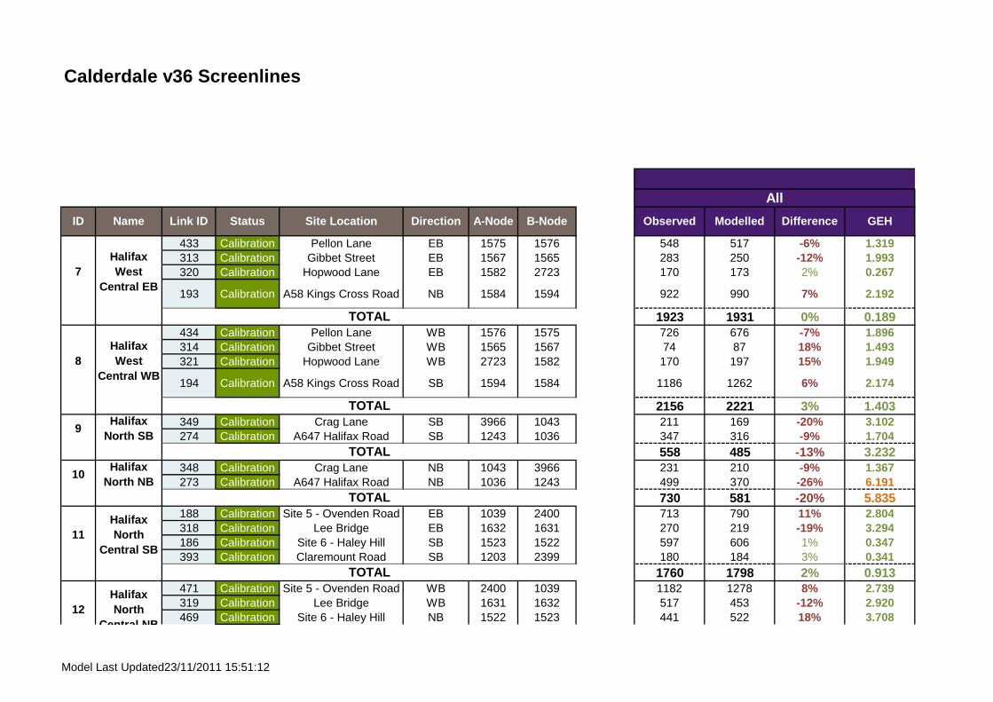
Calderdale v36 Screenlines
All
DifferenceModelledObserved GEHID Name Link ID Status Site Location Direction A-Node B-Node
433 Calibration Pellon Lane EB 1575 1576 548 517 -6% 1.319313 Calibration Gibbet Street EB 1567 1565 283 250 -12% 1.993320 Calibration Hopwood Lane EB 1582 2723 170 173 2% 0.267
193 Calibration A58 Kings Cross Road NB 1584 1594 922 990 7% 2.192
SL7 1923 1931 0% 0.189434 Calibration Pellon Lane WB 1576 1575 726 676 -7% 1.896314 Calibration Gibbet Street WB 1565 1567 74 87 18% 1.493321 Calibration Hopwood Lane WB 2723 1582 170 197 15% 1.949
194 Calibration A58 Kings Cross Road SB 1594 1584 1186 1262 6% 2.174
SL8 2156 2221 3% 1.403349 Calibration Crag Lane SB 3966 1043 211 169 -20% 3.102274 Calibration A647 Halifax Road SB 1243 1036 347 316 -9% 1.704
SL9 558 485 -13% 3.232348 Calibration Crag Lane NB 1043 3966 231 210 -9% 1.367273 Calibration A647 Halifax Road NB 1036 1243 499 370 -26% 6.191
SL10 730 581 -20% 5.835188 Calibration Site 5 - Ovenden Road EB 1039 2400 713 790 11% 2.804318 Calibration Lee Bridge EB 1632 1631 270 219 -19% 3.294186 Calibration Site 6 - Haley Hill SB 1523 1522 597 606 1% 0.347393 Calibration Claremount Road SB 1203 2399 180 184 3% 0.341
SL11 1760 1798 2% 0.913471 Calibration Site 5 - Ovenden Road WB 2400 1039 1182 1278 8% 2.739319 Calibration Lee Bridge WB 1631 1632 517 453 -12% 2.920469 Calibration Site 6 - Haley Hill NB 1522 1523 441 522 18% 3.708
TOTAL
11Halifax North
Central SB
TOTAL
12Halifax North
Central NB
TOTAL
TOTAL
8Halifax West
Central WB
TOTAL
9Halifax
North SB
10Halifax
North NB
7Halifax West
Central EB
Model Last Updated23/11/2011 15:51:12
ukmdj002
Text Box
PM

Calderdale v36 Screenlines
All
DifferenceModelledObserved GEHID Name Link ID Status Site Location Direction A-Node B-Node
392 Calibration Claremount Road NB 2399 1203 230 202 -12% 1.900SL12 2371 2456 4% 1.734
200 Calibration A58 West of WB 4238 1168 719 733 2% 0.528332 Calibration Church Lane NB 3362 1007 347 405 16% 2.943
SL13 1067 1138 7% 2.148199 Calibration A58 West of EB 1168 4238 677 625 -8% 2.025333 Calibration Church Lane SB 1007 3362 281 474 68% 9.895
SL14 958 1099 15% 4.384490 Calibration Victoria Road EB 3477 4036 230 240 5% 0.677405 Calibration Jepson Lane SB 4408 3371 351 330 -6% 1.118
SL15 581 571 -2% 0.427491 Calibration Victoria Road WB 4036 3477 530 552 4% 0.965404 Calibration Jepson Lane NB 3371 4408 400 423 6% 1.134
SL16 930 975 5% 1.472166 Calibration A6025 Park Road SB 3245 3358 595 545 -9% 2.126409 Calibration Lower Edge Road WB 3366 3367 220 175 -20% 3.168
164 Calibration B6114 Dewsbury Road WB 4104 3187 427 499 17% 3.353
SL17 1242 1219 -2% 0.659165 Calibration A6025 Park Road NB 3358 3245 549 492 -10% 2.486408 Calibration Lower Edge Road EB 3367 3366 414 445 7% 1.463
163 Calibration B6114 Dewsbury Road EB 3187 4104 535 437 -18% 4.474
SL18 1499 1374 -8% 3.2993 Calibration Crowtress Lane NB 3176 3175 302 385 27% 4.475
14Halifax East EB
TOTAL
15Elland
West EBTOTAL
16Elland
West WBTOTAL
17Elland East
WB
TOTAL
18Elland East
EB
TOTAL
Central NB
TOTAL
13Halifax
East WBTOTAL
19Brighouse
Model Last Updated23/11/2011 15:51:12
ukmdj002
Text Box
PM

Calderdale v36 Screenlines
All
DifferenceModelledObserved GEHID Name Link ID Status Site Location Direction A-Node B-Node
461 CalibrationSite 12 - A641
Huddersfield RoadNB 3132 3125 856 835 -2% 0.729
SL19 1158 1220 5% 1.7904 Calibration Crowtrees Lane SB 3175 3176 276 308 11% 1.850
178 CalibrationSite 12 - A641
Huddersfield RoadSB 3125 3132 916 891 -3% 0.838
SL20 1192 1198 1% 0.185462 Calibration Site 13 - A644 WB 3097 3095 381 416 9% 1.743442 Calibration Coal Pit Lane WB 4095 4096 60 60 0% 0.020
241 CalibrationA643 Cleckheaton
RoadSB 3070 3068 367 317 -14% 2.693
SL21 808 793 -2% 0.537179 Calibration Site 13 - A644 EB 3095 3097 769 852 11% 2.931441 Calibration Coal Pit Lane EB 4096 4095 262 238 -9% 1.528
240 CalibrationA643 Cleckheaton
RoadNB 3068 3070 409 427 5% 0.902
SL22 1440 1518 5% 2.021249 Calibration A644 North of SB 3205 3169 443 438 -1% 0.211
235 CalibrationA641 North of
BrighouseSB 3085 3086 868 924 6% 1.860
SL23 1311 1362 4% 1.402248 Calibration A644 North of NB 3169 3205 464 507 9% 1.949
234 CalibrationA641 North of
BirghouseNB 3086 3085 769 642 -17% 4.783
SL24 1233 1149 -7% 2.438192 Calibration Site 2 - A646 Burnley EB 1094 1095 587 549 -6% 1.589
Brighouse North NB
Sowerby
TOTAL
19Brighouse South NB
TOTAL
20Brighouse South SB
21Brighouse East WB
TOTAL
22Brighouse
East EB
TOTAL
TOTAL
23Brighouse North SB
TOTAL
24
Model Last Updated23/11/2011 15:51:12
ukmdj002
Text Box
PM

Calderdale v36 Screenlines
All
DifferenceModelledObserved GEHID Name Link ID Status Site Location Direction A-Node B-Node
195 Calibration A58 Calder Bridge NEB 1113 2275 692 676 -2% 0.620
211 Calibration A6026 Wakefield Road WB 1354 1355 481 386 -20% 4.591
SL25 1760 1611 -9% 3.645475 Calibration Site 2 - A646 Burnley WB 1095 1094 780 707 -9% 2.682196 Calibration A58 Calder Bridge SWB 2275 1113 926 984 6% 1.896
210 Calibration A6026 Wakefield Road EB 1355 1354 364 314 -14% 2.725
SL26 2070 2005 -3% 1.434364 Calibration Hopwood Lane EB 2332 2341 151 115 -24% 3.093338 Calibration Parkinson Lane EB 1110 2340 174 184 6% 0.765261 Calibration A646 Burnley Road EB 1428 1080 431 348 -19% 4.204
SL27 756 647 -14% 4.095365 Calibration Hopwood Lane WB 2341 2332 200 155 -23% 3.384339 Calibration Parkinson Lane WB 2340 1110 240 205 -15% 2.335262 Calibration A646 Burnley Road WB 1080 1428 651 646 -1% 0.211
SL28 1091 1005 -8% 2.63431 Calibration Freeschool Lane EB 2631 1012 273 388 42% 6.31833 Calibration Skircoat Moor Road EB 1390 1009 526 618 18% 3.876
SL29 799 1006 26% 6.90932 Calibration Freeschool Lane WB 1012 2631 410 353 -14% 2.87234 Calibration Skircoat Moor Road WB 1009 1390 417 509 22% 4.278
SL30 827 863 4% 1.238
25Sowerby
Bridge NB
TOTAL
Halifax South East
NBTOTAL
28Halifax
South East SB
TOTAL
29Saville
Park EBTOTAL
30Saville
Park WB
TOTAL
26Sowerby
Bridge SB
TOTAL
27
Model Last Updated23/11/2011 15:51:12
ukmdj002
Text Box
PM

Appendix G
JOURNEY TIME ROUTE RESULTS
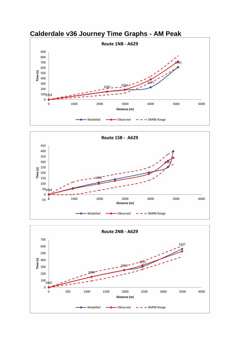
Calderdale v36 Journey Time Graphs - AM Peak
3354
32873264
3277
1665
0
100
200
300
400
500
600
700
800
900
0 1000 2000 3000 4000 5000 6000
Tim
e (
s)
Distance (m)
Route 1NB - A629
Modelled Observed DMRB Range
1664
3265
8007
-50
0
50
100
150
200
250
300
350
400
450
0 1000 2000 3000 4000 5000 6000
Tim
e (
s)
Distance (m)
Route 1SB - A629
Modelled Observed DMRB Range
1665
1008
10141015
1037
0
100
200
300
400
500
600
700
0 500 1000 1500 2000 2500 3000 3500 4000
Tim
e (
s)
Distance (m)
Route 2NB - A629
Modelled Observed DMRB Range

1551
1015
1014
1008
1665
0
100
200
300
400
500
600
700
800
0 500 1000 1500 2000 2500 3000 3500 4000
Tim
e (
s)
Distance (m)
Route 2SB - A629
Modelled Observed DMRB Range
1037
1058
1065
1064
1086
0
100
200
300
400
500
600
700
0 500 1000 1500 2000 2500 3000 3500 4000 4500 5000
Tim
e (
s)
Distance (m)
Route 3WB - A646/A58
Modelled Observed DMRB Range
1086
10641065
1058
1545
0
100
200
300
400
500
600
0 500 1000 1500 2000 2500 3000 3500 4000 4500 5000
Tim
e (
s)
Distance (m)
Route 3EB - A646/A58
Modelled Observed DMRB Range

1552
1038
1039
2415
3995
1246
-100
0
100
200
300
400
500
600
0 1000 2000 3000 4000 5000 6000 7000
Tim
e (
s)
Distance (m)
Route 4NB - A629 Ovenden Road
Modelled Observed DMRB Range
1246
3995
2415
10391038
1552
0
100
200
300
400
500
600
700
0 1000 2000 3000 4000 5000 6000 7000
Tim
e (
s)
Distance (m)
Route 4SB - A629 Ovenden Road
Modelled Observed DMRB Range
1035
1351
0
50
100
150
200
250
0 200 400 600 800 1000 1200 1400 1600 1800 2000
Tim
e (
s)
Distance (m)
Route 5NB - Queensbury Road
Modelled Observed DMRB Range

1351
1541
0
20
40
60
80
100
120
140
160
180
200
0 200 400 600 800 1000 1200 1400 1600 1800
Tim
e (
s)
Distance (m)
Route 5SB - Queensbury Road
Modelled Observed DMRB Range
1064
1061
1014
1019
1177
27871524
1035
0
100
200
300
400
500
600
700
800
900
0 1000 2000 3000 4000 5000 6000
Tim
e (
s)
Distance (m)
Route 6NB - Queensbury Road/Freeschool Lane
Modelled Observed DMRB Range
1035
15242787
1177
1019
1014
2244
1064
0
100
200
300
400
500
600
700
800
900
1000
0 1000 2000 3000 4000 5000 6000
Tim
e (
s)
Distance (m)
Route 6SB - Queensbury Road/FreeSchool Lane
Modelled Observed DMRB Range

.
3934
1153
1033
1529
0
100
200
300
400
500
600
0 500 1000 1500 2000 2500 3000 3500 4000 4500
Tim
e (
s)
Distance (m)
Route 7WB - A58
Modelled Observed DMRB Range
15281033
1153
3934
-100
0
100
200
300
400
500
600
700
0 500 1000 1500 2000 2500 3000 3500 4000 4500
Tim
e (
s)
Distance (m)
Route 7EB - A58
Modelled Observed DMRB Range
3132
3930
3908
3205
0
100
200
300
400
500
600
700
0 500 1000 1500 2000 2500 3000 3500 4000 4500
Tim
e (
s)
Distance (m)
Route 8NB - A644/A641
Modelled Observed DMRB Range

3205
3040
3930
3132
0
100
200
300
400
500
600
700
800
900
1000
0 500 1000 1500 2000 2500 3000 3500 4000 4500
Tim
e (
s)
Distance (m)
Route 8SB- A644/A641
Modelled Observed DMRB Range
3929
3913
0
50
100
150
200
250
0 500 1000 1500 2000 2500
Tim
e (
s)
Distance (m)
Route 9WB - A6107/B6114/Rochdale Road
Modelled Observed DMRB Range
3192
3929
0
50
100
150
200
250
300
350
0 500 1000 1500 2000 2500
Tim
e (
s)
Distance (m)
Route 9EB - A6107/B6114/Rochdale Road
Modelled Observed DMRB Range

3913
3249
3947
3499
3523
-50
0
50
100
150
200
250
300
350
400
450
500
0 500 1000 1500 2000 2500 3000 3500 4000 4500
Tim
e (
s)
Distance (m)
Route 10WB - A6107/B6114/Rochdale Road
Modelled Observed DMRB Range
3523
3499
3947
3249
3192
0
100
200
300
400
500
600
700
800
0 500 1000 1500 2000 2500 3000 3500 4000 4500
Tim
e (
s)
Distance (m)
Route 10EB - A6107/B6114/Rochdale Road
Modelled Observed DMRB Range
4242
3477
3494
3948
1663
0
100
200
300
400
500
600
700
800
900
0 500 1000 1500 2000 2500 3000 3500 4000 4500 5000
Tim
e (
s)
Distance (m)
Route 11NB - A629/Stainland Road/Blackley Road
Modelled Observed DMRB Range

1663
3948
3494
3477
4242
0
100
200
300
400
500
600
0 500 1000 1500 2000 2500 3000 3500 4000 4500 5000
Tim
e (
s)
Distance (m)
Route 11SB - A629/Stainland Road/Blackley Road Southbound
Modelled Observed DMRB Range
1663
1460
1091
1083
1084
1086
-100
0
100
200
300
400
500
600
0 500 1000 1500 2000 2500 3000 3500 4000 4500 5000
Tim
e (
s)
Distance (m)
Route 12NB - A629/Stainland Road/Blackley Road
Modelled Observed DMRB Range
1086
1084
1083
1091
1460
1663
0
100
200
300
400
500
600
700
800
0 500 1000 1500 2000 2500 3000 3500 4000 4500 5000
Tim
e (
s)
Distance (m)
Route 12SB - A629/Stainland Road/Blackley Road
Modelled Observed DMRB Range

3242
1006
1183
1033
0
100
200
300
400
500
600
700
800
0 1000 2000 3000 4000 5000 6000
Tim
e (
s)
Distance (m)
Route 13NB - Halifax/Southowram/Brighouse A644 towards Halifax
Modelled Observed DMRB Range
1033
1183
1006
3242
0
100
200
300
400
500
600
0 1000 2000 3000 4000 5000 6000
Tim
e (
s)
Distance (m)
Route 13SB - Halifax/Southowram/Brighouse A644 towards
motorway
Modelled Observed DMRB Range
3103
3920
39093908
3242
0
100
200
300
400
500
600
700
0 500 1000 1500 2000 2500 3000 3500
Tim
e (
s)
Distance (m)
Route 14NB - Halifax/Southowram/Brighouse A644 towards
motorway
Modelled Observed DMRB Range

3242
3908
3909
3093
3103
0
50
100
150
200
250
300
350
400
450
0 500 1000 1500 2000 2500 3000 3500
Tim
e (
s)
Distance (m)
Route 14SB - Halifax/Southowram/Brighouse A644 towards
motorway
Modelled Observed DMRB Range
1008
1062
1064
1067
1069
1050
0
100
200
300
400
500
600
700
0 500 1000 1500 2000 2500 3000 3500 4000 4500
Tim
e (
s)
Distance (m)
Route 15NB - Quenens Road/Dryclough Lane
Modelled Observed DMRB Range
1050
1069
1067
1064
1062
1008
-100
0
100
200
300
400
500
600
700
0 500 1000 1500 2000 2500 3000 3500 4000 4500
Tim
e (
s)
Distance (m)
Route 15SB - Queens Road/Dryclough Lane
Modelled Observed DMRB Range

3242
3908
3909
4281
3932
0
50
100
150
200
250
300
350
400
450
0 500 1000 1500 2000 2500 3000 3500 4000
Tim
e (
s)
Distance (m)
Route 16NB - A641/A6025
Modelled Observed DMRB Range
3932
30894281
3909
3908
3242
0
50
100
150
200
250
300
350
400
450
500
0 500 1000 1500 2000 2500 3000 3500 4000
Tim
e (
s)
Distance (m)
Route 16SB - A641/A6025
Modelled Observed DMRB Range
3247
3242
0
50
100
150
200
250
300
350
0 500 1000 1500 2000 2500 3000 3500 4000
Tim
e (
s)
Distance (m)
Route 17NB - A641/A6025
Modelled Observed DMRB Range

3242
3247
0
50
100
150
200
250
300
350
0 500 1000 1500 2000 2500 3000 3500 4000
Tim
e (
s)
Distance (m)
Route 17SB - A641/A6025
Modelled Observed DMRB Range
3430
3402
3537
0
50
100
150
200
250
300
350
400
450
0 2000 4000 6000 8000 10000 12000
Tim
e (
s)
Distance (m)
Route 18WB - M62
Modelled Observed DMRB Range
4286
3397
3413
-50
0
50
100
150
200
250
300
350
400
0 1000 2000 3000 4000 5000 6000 7000 8000 9000
Tim
e (
s)
Distance (m)
Route 18EB - M62
Modelled Observed DMRB Range

3446
3430
0
50
100
150
200
250
300
0 500 1000 1500 2000 2500 3000 3500 4000
Tim
e (
s)
Distance (m)
Route 19WB - M62
Modelled Observed DMRB Range
3413
3445
0
50
100
150
200
250
300
350
400
0 1000 2000 3000 4000 5000 6000
Tim
e (
s)
Distance (m)
Route 19EB - M62
Modelled Observed DMRB Range

Calderdale v36 Journey Time Graphs - Inter Peak
3354
32873264
3277
1665
0
50
100
150
200
250
300
350
400
450
500
0 1000 2000 3000 4000 5000 6000
Tim
e (
s)
Distance (m)
Route 1NB - A629
Modelled Observed DMRB Range
1664
3278
3265
3286
3298
8007
3354
-50
0
50
100
150
200
250
300
350
400
0 1000 2000 3000 4000 5000 6000
Tim
e (
s)
Distance (m)
Route 1SB - A629
Modelled Observed DMRB Range
1665
1008
1014
1015
1037
0
100
200
300
400
500
600
0 500 1000 1500 2000 2500 3000 3500 4000
Tim
e (
s)
Distance (m)
Route 2NB - A629
Modelled Observed DMRB Range

1551
1015
1014
1008
1665
0
100
200
300
400
500
600
700
800
0 500 1000 1500 2000 2500 3000 3500 4000
Tim
e (
s)
Distance (m)
Route 2SB - A629
Modelled Observed DMRB Range
1037
1058
1065
1064
1086
0
100
200
300
400
500
600
0 500 1000 1500 2000 2500 3000 3500 4000 4500 5000
Tim
e (
s)
Distance (m)
Route 3WB - A646/A58
Modelled Observed DMRB Range
1086
10641065
1058
1545
0
100
200
300
400
500
600
0 500 1000 1500 2000 2500 3000 3500 4000 4500 5000
Tim
e (
s)
Distance (m)
Route 3EB - A646/A58
Modelled Observed DMRB Range

15521038
1039
2415
3995
1246
-100
0
100
200
300
400
500
600
0 1000 2000 3000 4000 5000 6000 7000
Tim
e (
s)
Distance (m)
Route 4NB - A629 Ovenden Road
Modelled Observed DMRB Range
1246
3995
2415
10391038
1552
0
100
200
300
400
500
600
700
0 1000 2000 3000 4000 5000 6000 7000
Tim
e (
s)
Distance (m)
Route 4SB - A629 Ovenden Road
Modelled Observed DMRB Range
1035
1351
0
20
40
60
80
100
120
140
160
180
200
0 200 400 600 800 1000 1200 1400 1600 1800 2000
Tim
e (
s)
Distance (m)
Route 5NB - Queensbury Road
Modelled Observed DMRB Range

1351
1541
0
20
40
60
80
100
120
140
160
180
200
0 200 400 600 800 1000 1200 1400 1600 1800
Tim
e (
s)
Distance (m)
Route 5SB - Queensbury Road
Modelled Observed DMRB Range
1064
1061
1014
1019
1177
27871524
1035
0
100
200
300
400
500
600
700
800
900
0 1000 2000 3000 4000 5000 6000
Tim
e (
s)
Distance (m)
Route 6NB - Queensbury Road/Freeschool Lane
Modelled Observed DMRB Range
10351524
27871177
1019
1014
2244
1064
0
100
200
300
400
500
600
700
800
900
1000
0 1000 2000 3000 4000 5000 6000
Tim
e (
s)
Distance (m)
Route 6SB - Queensbury Road/FreeSchool Lane
Modelled Observed DMRB Range

3934
1153
1033
1529
0
50
100
150
200
250
300
350
400
450
0 500 1000 1500 2000 2500 3000 3500 4000 4500
Tim
e (
s)
Distance (m)
Route 7WB - A58
Modelled Observed DMRB Range
1528
1033
1153
3934
-50
0
50
100
150
200
250
300
350
400
450
0 500 1000 1500 2000 2500 3000 3500 4000 4500
Tim
e (
s)
Distance (m)
Route 7EB - A58
Modelled Observed DMRB Range
3132
3930
3908
3205
0
100
200
300
400
500
600
0 500 1000 1500 2000 2500 3000 3500 4000 4500
Tim
e (
s)
Distance (m)
Route 8NB - A644/A641
Modelled Observed DMRB Range

3205
3040
3930
3132
0
100
200
300
400
500
600
0 500 1000 1500 2000 2500 3000 3500 4000 4500
Tim
e (
s)
Distance (m)
Route 8SB- A644/A641
Modelled Observed DMRB Range
3929
3913
0
50
100
150
200
250
0 500 1000 1500 2000 2500
Tim
e (
s)
Distance (m)
Route 9WB - A6107/B6114/Rochdale Road
Modelled Observed DMRB Range
3192
3929
0
50
100
150
200
250
0 500 1000 1500 2000 2500
Tim
e (
s)
Distance (m)
Route 9EB - A6107/B6114/Rochdale Road
Modelled Observed DMRB Range

3913
3249
3947
3499
3523
-50
0
50
100
150
200
250
300
350
400
450
0 500 1000 1500 2000 2500 3000 3500 4000 4500
Tim
e (
s)
Distance (m)
Route 10WB - A6107/B6114/Rochdale Road
Modelled Observed DMRB Range
3523
3499
3947
3249
3192
0
100
200
300
400
500
600
0 500 1000 1500 2000 2500 3000 3500 4000 4500
Tim
e (
s)
Distance (m)
Route 10EB - A6107/B6114/Rochdale Road
Modelled Observed DMRB Range
4242
3477
3494
3948
1663
0
100
200
300
400
500
600
700
0 500 1000 1500 2000 2500 3000 3500 4000 4500 5000
Tim
e (
s)
Distance (m)
Route 11NB - A629/Stainland Road/Blackley Road
Modelled Observed DMRB Range

1663
3948
3494
3477
4242
0
100
200
300
400
500
600
700
0 500 1000 1500 2000 2500 3000 3500 4000 4500 5000
Tim
e (
s)
Distance (m)
Route 11SB - A629/Stainland Road/Blackley Road Southbound
Modelled Observed DMRB Range
1663
1460
1091
1083
1084
1086
-100
0
100
200
300
400
500
600
0 500 1000 1500 2000 2500 3000 3500 4000 4500 5000
Tim
e (
s)
Distance (m)
Route 12NB - A629/Stainland Road/Blackley Road
Modelled Observed DMRB Range
1086
1084
1083
1091
1460
1663
0
100
200
300
400
500
600
700
0 500 1000 1500 2000 2500 3000 3500 4000 4500 5000
Tim
e (
s)
Distance (m)
Route 12SB - A629/Stainland Road/Blackley Road
Modelled Observed DMRB Range

3242
1006
1183
1033
0
100
200
300
400
500
600
700
0 1000 2000 3000 4000 5000 6000
Tim
e (
s)
Distance (m)
Route 13NB - Halifax/Southowram/Brighouse A644 towards Halifax
Modelled Observed DMRB Range
1033
1183
1006
3242
0
100
200
300
400
500
600
700
0 1000 2000 3000 4000 5000 6000
Tim
e (
s)
Distance (m)
Route 13SB - Halifax/Southowram/Brighouse A644 towards
motorway
Modelled Observed DMRB Range
3103
3920
3909
3908
3242
0
50
100
150
200
250
300
350
400
0 500 1000 1500 2000 2500 3000 3500
Tim
e (
s)
Distance (m)
Route 14NB - Halifax/Southowram/Brighouse A644 towards
motorway
Modelled Observed DMRB Range

3242
3908
3909
3093
3103
0
50
100
150
200
250
300
350
400
0 500 1000 1500 2000 2500 3000 3500
Tim
e (
s)
Distance (m)
Route 14SB - Halifax/Southowram/Brighouse A644 towards
motorway
Modelled Observed DMRB Range
1008
1062
1064
1067
1069
1050
0
100
200
300
400
500
600
700
800
900
0 500 1000 1500 2000 2500 3000 3500 4000 4500
Tim
e (
s)
Distance (m)
Route 15NB - Quenens Road/Dryclough Lane
Modelled Observed DMRB Range
1050
1069
1067
1064
1062
1008
-100
0
100
200
300
400
500
600
700
0 500 1000 1500 2000 2500 3000 3500 4000 4500
Tim
e (
s)
Distance (m)
Route 15SB - Queens Road/Dryclough Lane
Modelled Observed DMRB Range

3242
3908
3909
4281
3932
0
50
100
150
200
250
300
350
400
450
0 500 1000 1500 2000 2500 3000 3500 4000
Tim
e (
s)
Distance (m)
Route 16NB - A641/A6025
Modelled Observed DMRB Range
3932
30894281
3909
3908
3242
0
50
100
150
200
250
300
350
400
450
0 500 1000 1500 2000 2500 3000 3500 4000
Tim
e (
s)
Distance (m)
Route 16SB - A641/A6025
Modelled Observed DMRB Range
3247
3242
0
50
100
150
200
250
300
350
0 500 1000 1500 2000 2500 3000 3500 4000
Tim
e (
s)
Distance (m)
Route 17NB - A641/A6025
Modelled Observed DMRB Range

3242
3247
0
50
100
150
200
250
300
350
0 500 1000 1500 2000 2500 3000 3500 4000
Tim
e (
s)
Distance (m)
Route 17SB - A641/A6025
Modelled Observed DMRB Range
3430
3402
3537
0
50
100
150
200
250
300
350
400
450
0 2000 4000 6000 8000 10000 12000
Tim
e (
s)
Distance (m)
Route 18WB - M62
Modelled Observed DMRB Range
4286
3397
3413
-50
0
50
100
150
200
250
300
350
400
0 1000 2000 3000 4000 5000 6000 7000 8000 9000
Tim
e (
s)
Distance (m)
Route 18EB - M62
Modelled Observed DMRB Range

3446
3430
0
50
100
150
200
250
300
0 500 1000 1500 2000 2500 3000 3500 4000
Tim
e (
s)
Distance (m)
Route 19WB - M62
Modelled Observed DMRB Range
3413
3445
0
50
100
150
200
250
300
0 1000 2000 3000 4000 5000 6000
Tim
e (
s)
Distance (m)
Route 19EB - M62
Modelled Observed DMRB Range

Calderdale v36 Journey Time Graphs - PM Peak
3354
32873264
3277
1665
0
100
200
300
400
500
600
700
800
0 1000 2000 3000 4000 5000 6000
Tim
e (
s)
Distance (m)
Route 1NB - A629
Modelled Observed DMRB Range
1664
3278
32653286
3298
8007
3354
-100
0
100
200
300
400
500
600
0 1000 2000 3000 4000 5000 6000
Tim
e (
s)
Distance (m)
Route 1SB - A629
Modelled Observed DMRB Range
1665
1008
10141015
1037
0
100
200
300
400
500
600
700
0 500 1000 1500 2000 2500 3000 3500 4000
Tim
e (
s)
Distance (m)
Route 2NB - A629
Modelled Observed DMRB Range

1551
10151014
1008
1665
0
100
200
300
400
500
600
700
800
900
1000
0 500 1000 1500 2000 2500 3000 3500 4000
Tim
e (
s)
Distance (m)
Route 2SB - A629
Modelled Observed DMRB Range
1037
1058
1065
1064
1086
0
100
200
300
400
500
600
700
0 500 1000 1500 2000 2500 3000 3500 4000 4500 5000
Tim
e (
s)
Distance (m)
Route 3WB - A646/A58
Modelled Observed DMRB Range
1086
10641065
1058
1545
0
100
200
300
400
500
600
0 500 1000 1500 2000 2500 3000 3500 4000 4500 5000
Tim
e (
s)
Distance (m)
Route 3EB - A646/A58
Modelled Observed DMRB Range

1552
1038
1039
2415
3995
1246
-100
0
100
200
300
400
500
600
700
0 1000 2000 3000 4000 5000 6000 7000
Tim
e (
s)
Distance (m)
Route 4NB - A629 Ovenden Road
Modelled Observed DMRB Range
1246
3995
2415
10391038
1552
0
100
200
300
400
500
600
0 1000 2000 3000 4000 5000 6000 7000
Tim
e (
s)
Distance (m)
Route 4SB - A629 Ovenden Road
Modelled Observed DMRB Range
1035
1351
0
20
40
60
80
100
120
140
160
180
200
0 200 400 600 800 1000 1200 1400 1600 1800 2000
Tim
e (
s)
Distance (m)
Route 5NB - Queensbury Road
Modelled Observed DMRB Range

1351
1541
0
20
40
60
80
100
120
140
160
180
200
0 200 400 600 800 1000 1200 1400 1600 1800
Tim
e (
s)
Distance (m)
Route 5SB - Queensbury Road
Modelled Observed DMRB Range
1064
1061
1014
1019
1177
27871524
1035
0
100
200
300
400
500
600
700
800
900
1000
0 1000 2000 3000 4000 5000 6000
Tim
e (
s)
Distance (m)
Route 6NB - Queensbury Road/Freeschool Lane
Modelled Observed DMRB Range
10351524
27871177
1019
1014
2244
1064
0
200
400
600
800
1000
1200
0 1000 2000 3000 4000 5000 6000
Tim
e (
s)
Distance (m)
Route 6SB - Queensbury Road/FreeSchool Lane
Modelled Observed DMRB Range

3934
1153
1033
1529
0
100
200
300
400
500
600
0 500 1000 1500 2000 2500 3000 3500 4000 4500
Tim
e (
s)
Distance (m)
Route 7WB - A58
Modelled Observed DMRB Range
15281033
1153
3934
-100
0
100
200
300
400
500
600
700
800
0 500 1000 1500 2000 2500 3000 3500 4000 4500
Tim
e (
s)
Distance (m)
Route 7EB - A58
Modelled Observed DMRB Range
3132
3930
3908
3205
0
100
200
300
400
500
600
700
0 500 1000 1500 2000 2500 3000 3500 4000 4500
Tim
e (
s)
Distance (m)
Route 8NB - A644/A641
Modelled Observed DMRB Range

3205
3040
3930
3132
0
100
200
300
400
500
600
700
800
0 500 1000 1500 2000 2500 3000 3500 4000 4500
Tim
e (
s)
Distance (m)
Route 8SB- A644/A641
Modelled Observed DMRB Range
3929
3913
0
50
100
150
200
250
0 500 1000 1500 2000 2500
Tim
e (
s)
Distance (m)
Route 9WB - A6107/B6114/Rochdale Road
Modelled Observed DMRB Range
3192
3929
0
50
100
150
200
250
300
350
0 500 1000 1500 2000 2500
Tim
e (
s)
Distance (m)
Route 9EB - A6107/B6114/Rochdale Road
Modelled Observed DMRB Range

3913
3249
3947
3499
3523
-100
0
100
200
300
400
500
600
0 500 1000 1500 2000 2500 3000 3500 4000 4500
Tim
e (
s)
Distance (m)
Route 10WB - A6107/B6114/Rochdale Road
Modelled Observed DMRB Range
3523
3499
3947
3249
3192
0
100
200
300
400
500
600
0 500 1000 1500 2000 2500 3000 3500 4000 4500
Tim
e (
s)
Distance (m)
Route 10EB - A6107/B6114/Rochdale Road
Modelled Observed DMRB Range
4242
3477
3494
3948
1663
0
100
200
300
400
500
600
700
0 500 1000 1500 2000 2500 3000 3500 4000 4500 5000
Tim
e (
s)
Distance (m)
Route 11NB - A629/Stainland Road/Blackley Road
Modelled Observed DMRB Range

1663
3948
3494
3477
4242
0
100
200
300
400
500
600
700
0 500 1000 1500 2000 2500 3000 3500 4000 4500 5000
Tim
e (
s)
Distance (m)
Route 11SB - A629/Stainland Road/Blackley Road Southbound
Modelled Observed DMRB Range
1663
1460
1091
1083
1084
1086
-100
0
100
200
300
400
500
600
700
800
0 500 1000 1500 2000 2500 3000 3500 4000 4500 5000
Tim
e (
s)
Distance (m)
Route 12NB - A629/Stainland Road/Blackley Road
Modelled Observed DMRB Range
1086
1084
1083
1091
1460
1663
0
100
200
300
400
500
600
700
0 500 1000 1500 2000 2500 3000 3500 4000 4500 5000
Tim
e (
s)
Distance (m)
Route 12SB - A629/Stainland Road/Blackley Road
Modelled Observed DMRB Range

3242
1006
1183
1033
0
100
200
300
400
500
600
700
0 1000 2000 3000 4000 5000 6000
Tim
e (
s)
Distance (m)
Route 13NB - Halifax/Southowram/Brighouse A644 towards Halifax
Modelled Observed DMRB Range
1033
1183
1006
3242
0
100
200
300
400
500
600
0 1000 2000 3000 4000 5000 6000
Tim
e (
s)
Distance (m)
Route 13SB - Halifax/Southowram/Brighouse A644 towards
motorway
Modelled Observed DMRB Range
3103
3920
39093908
3242
0
200
400
600
800
1000
0 500 1000 1500 2000 2500 3000 3500
Tim
e (
s)
Distance (m)
Route 14NB - Halifax/Southowram/Brighouse A644 towards
motorway
Modelled Observed DMRB Range

3242
3908
3909
3093
3103
0
100
200
300
400
500
600
0 500 1000 1500 2000 2500 3000 3500
Tim
e (
s)
Distance (m)
Route 14SB - Halifax/Southowram/Brighouse A644 towards
motorway
Modelled Observed DMRB Range
1008
1062
1064
1067
1069
1050
0
100
200
300
400
500
600
700
800
900
0 500 1000 1500 2000 2500 3000 3500 4000 4500
Tim
e (
s)
Distance (m)
Route 15NB - Quenens Road/Dryclough Lane
Modelled Observed DMRB Range
1050
1069
1067
1064
1062
1008
-100
0
100
200
300
400
500
600
700
800
900
1000
0 500 1000 1500 2000 2500 3000 3500 4000 4500
Tim
e (
s)
Distance (m)
Route 15SB - Queens Road/Dryclough Lane
Modelled Observed DMRB Range

3242
3908
3909
4281
3932
0
100
200
300
400
500
600
700
0 500 1000 1500 2000 2500 3000 3500 4000
Tim
e (
s)
Distance (m)
Route 16NB - A641/A6025
Modelled Observed DMRB Range
3932
30894281
3909
3908
3242
0
100
200
300
400
500
600
0 500 1000 1500 2000 2500 3000 3500 4000
Tim
e (
s)
Distance (m)
Route 16SB - A641/A6025
Modelled Observed DMRB Range
3247
3242
0
50
100
150
200
250
300
350
0 500 1000 1500 2000 2500 3000 3500 4000
Tim
e (
s)
Distance (m)
Route 17NB - A641/A6025
Modelled Observed DMRB Range

3242
3247
0
50
100
150
200
250
300
0 500 1000 1500 2000 2500 3000 3500 4000
Tim
e (
s)
Distance (m)
Route 17SB - A641/A6025
Modelled Observed DMRB Range
3430
3402
3537
0
50
100
150
200
250
300
350
400
450
500
0 2000 4000 6000 8000 10000 12000
Tim
e (
s)
Distance (m)
Route 18WB - M62
Modelled Observed DMRB Range
4286
3397
3413
-50
0
50
100
150
200
250
300
350
0 1000 2000 3000 4000 5000 6000 7000 8000 9000
Tim
e (
s)
Distance (m)
Route 18EB - M62
Modelled Observed DMRB Range

3446
3430
0
50
100
150
200
250
300
350
0 500 1000 1500 2000 2500 3000 3500 4000
Tim
e (
s)
Distance (m)
Route 19WB - M62
Modelled Observed DMRB Range
3413
3445
0
50
100
150
200
250
300
0 1000 2000 3000 4000 5000 6000
Tim
e (
s)
Distance (m)
Route 19EB - M62
Modelled Observed DMRB Range