Report: 1999-05-01 Measurement of the Ozone Concentration ...
70
CONTRACT NO. 95-337 FINAL REPORT MAY 1999 Measurement of the ·Ozone Concentration Aloft by Lidar During the Episode Monitoring Periods of the 1997 Southern California Ozone Study
Transcript of Report: 1999-05-01 Measurement of the Ozone Concentration ...

CONTRACT NO. 95-337 FINAL REPORT
MAY 1999
Measurement of the · Ozone Concentration Aloft by Lidar
During the Episode Monitoring Periods of the 1997 Southern California Ozone Study


Disclaimer
The statements and conclusions in this report are those of the NOAA/ERL/ETL and not
necessarily those of the California Air Resources Board. The mention of commercial products,
their source, and their use in connection with material reported herein is not to be construed as
actual or implied endorsement of such products.
- i -


Mr. George, and Ms. Lisa Olivier, meteorologist. Ms. Gloria Schurman, secretary, processed an
unusually large amount of paper work for the numerous person-trips to the field study site in a
timely and accurate manner. Dr. Bob Weber, physicist, and Mr. David Welsh, computer
specialist, in the ETL's System Demonstration and Integration Division (ET4) helped us in
downloading meteorological data and other information in SCOS97 from the ET4's web site.
This report was submitted in fulfillment of Contract #95-337 entitled "Measurement of
the Ozone Concentration Aloft by Lidar during the Episodic Monitoring Periods of the 1997
Southern California Ozone Study" by the National Oceanic and Atmospheric Administration's
Environmental Technology Laboratory under the sponsorship of the California Air Resources
Board. Special thanks are due to Mr. Leon Dolislager for his valuable help in providing
important information for the background of this experiment and managing field operations; and
for his critical review of the manuscript and many helpful suggestions. Work was completed as
of May 1999.
- iii -

Acknowledgments
Mr. Richard Marchbanks, optical engineer, re-designed the mechanical part of the two
dimensional scanner, re-coated the mirrors, and carried out miscellaneous hardware preparations.
The new design significantly improved the stability of the scanner. During the 1997 Southern
California Ozone Study (SCOS97) Experiment, Mr. Marchbanks was responsible for deploying
the ozone lidar at the site, and took a major role in setting up, realignment, troubleshooting, and
operation of the lidar. He was the only person in the crew that went to every episode in SCOS97.
Mr. Keith Koenig, computer engineer, upgraded the lidar's data acquisition system. He installed
new digitizer boards and a QNX operating system, re-wrote lidar operation programs for scanner
control and raw data acquisition. He wrote programs for real time display of lidar raw data and
real time display of preliminary ozone concentration and aerosol backscatter profiles, as well as
various programs for on-site noise removing and system calibration to support the real time data
analysis. The major improvement of the data acquisition system was the capability ofreal-time
display that enabled the crew to view the current ozone and aerosol vertical structure, and thus
helped them to make decisions about lidar operation (e.g., changing scanning parameters,
lengthen working hours if the structure was interesting). Dr. Christoph Senff, research scientist,
was one of the lead persons of the second-shift crew with an emphasis on science issues. His
parallel post-processing of the data in the intercomparisons and the first two-days of the first
episode in August 1997 provided a double check to the quality of data analysis. Dr. Wynn
Eberhard, physicist, gave advice to the planning of the operation and managed the budget of the
project. Ms. Kathleen Healy, computer analyst, set up a workstation in the lidar site to provide
on-site data analysis. She re-wrote the tape reading and raw data averaging program, and wrote
and modified all the data displaying programs in IDL language. Ms. Joanne George improved
the plotting subroutine in the data analysis programs. She also modified a color table in the data
display programs which covered a large dynamic range and thus allowed detailed structures and
time variations of aerosol profiles to be well distinguished in color graphics. Mr. David
Greenstone, student assistant, and Mr. Hutch Johnson, associate research scientist, were the
major field support personnel. The field supporting crew also included Mr. Koenig, Ms. Healy,
- ii -

TABLE OF CONTENTS
DISCLAIMER
ACKNOWLEDGMENTS
TABLE OF CONTENTS
LIST OF FIGURES
LIST OF APPENDICES
ABSTRACT ·
EXECUTIVE SUMMARY
BODY OF REPORT
I. INTRODUCTION
II. THE ETL OZONE LIDAR
2.1 The lidar system OPAL
2.2 Improvements of the scanning system
2.3 Upgrades of the data acquisition system ·
2.4 Improvements of data analysis
III. LIDAR OPERATION IN SCOS97
IV. OZONE AND AEROSOL CONCENTRATIONS ALOFT AS MEASURED BY LIDAR DURING HIGH OZONE EPISODES
V. SUMMARY AND DISCUSSIONS
REFERENCES
GLOSSARY OF TERMS, ABBREVIATIONS, AND SYMBOLS ·
APPENDIX A
APPENDIX B
APPENDIXC
APPENDIXD
APPENDIXE
FIGURES
- V -
ii
V
Vil
ix
xi
Xlll
1
3
3
8
8
9
11
13
19
23
25
26
27
29
30
32

- iv -

Figure 1
LIST OF FIGURES
Time-height charts of ozone concentrations and aerosol extinction coefficients at
355 nm during the episode of August 4-6, 1997
Figure 2 Time-height charts of ozone concentrations and aerosol extinction coefficients at
355 nm during the episode of September 3-7, 1997
Figure 3 Time-height charts of ozone concentrations and aerosol extinction coefficients at
355 nm during the episode of September 27-29, 1997
Figure 4 Time-height charts of ozone concentrations and aerosol extinction coefficients at
355 nm during the episode of August 22-23, 1997
Figure 5 Time-height charts of ozone concentrations and aerosol extinction coefficients at
355 nm during the episode of October 3-4, 1997
Figure 6 Time-height charts of ozone concentrations and aerosol extinction coefficients at
355 nm in the evening of August 4, 1997
Figure 7 Time-height chart of ozone concentrations and aerosol extinction coefficients at
355 nm during one scanning at about 2120 PST on August 4, 1997
Figure 8 Time-height charts of ozone concentrations and aerosol extinction coefficients at
355 nm from late afternoon to evening on September 5, 1997
Figure 9 Time-height chart of ozone concentrations and aerosol extinction coefficients at
355 nm during one scanning at about 1800 PST on September 5, 1997
Figure 10 Time-height charts of ozone concentrations and aerosol extinction coefficients at
355 nm in the evening on September 28, 1997
Figure 11 Time-height chart of ozone concentrations and aerosol extinction coefficients at
- vii -

- vi -

LIST OF APPENDICES
APPENDIX A
APPENDIXB
APPENDIXC
APPENDIXD
APPENDIXE
SCOS97's modeling domain of southern California and adjoining environs
Quotes from Reference 5: R. Lu and R.P. Turco, "Ozone distributions over
the Los Angeles basin: 3-dimensional simulations with the SMOG
model," Atmospheric Environment 30, No. 24, pp. 4155-4176 (1996).
(a) The model computation domain and topography
(b) The simulation results on line A-A'
Lidar operation days in SCOS97
(a) Schematic figure of the lidar system OPAL
(b) Optical layout of the transmitter and receiver of OP AL
Analysis on the statistical error in ozone concentrations
- ix -

355 run during one scanning at about 1720 PST on September 28, 1997
Figure 12 Time-height chart of ozone concentrations and aerosol extinction coefficients at
355 run during one scanning at about 1820 PST on September 28, 1997
Figure 13 Time-height charts of ozone concentrations and aerosol extinction coefficients at
355 run September 29, 1997
Figure 14 Time-height charts of ozone concentrations and aerosol extinction coefficients at 355 run in three scanning operations at about 0620, 0720, and 0820 PST on September 29, 1997
- viii -

ABSTRACT
In the SCOS97-NARSTO1 field study the NOAA Environmental Technology Laboratory
(NOAA/ETL)'s ozone profiling atmospheric lidar2·3 (OPAL) was deployed in the Los Angeles
urban area (El Monte Airport). During intensive operation periods (IOPs), OPAL operated
continuously for more than 20 hours per day, providing vertical profiles of ozone and aerosol in
an area important for understanding ozone evolution and transport, as well as for air quality
model performance validation. In this 4-month long field campaign, OP AL detected persistent
ozone and aerosol layers aloft on most days during the IOPs. Very frequently, a lower layer of
ozone and aerosol at 1000-1500 m (msl) and a higher layer of ozone and aerosol at 2000-2500 m
(ms!) were observed by the lidar. These layers existed simultaneously during a time period from
the late afternoon till midnight, when they started to dissipate. Sometimes, they persisted
through the night and could be seen in the early morning.
- xi -

- X -

EXECUTIVE SUMMARY
This final report describes the profiling of ozone and aerosol during the SCOS97-
NARSTO field measurement campaign by the NOAA Environmental Technology Laboratory
(NOAA/ETL)'s ozone profiling atmospheric lidar,3 (OPAL) in El Monte, CA.
OPAL transmits three ultraviolet (UV) wavelengths (266,289, and 355 nm) in an eye
safe manner. The first two are for ozone profiling and the third is for aerosol profiling. The lidar
has the unique capability of measuring profiles of ozone concentrations from near the surface to
2-3 km above the ground level and aerosol profiles up to 10 km. Prior to the SCOS97-NARSTO
field study, a redesigned 2-dimensional scanner was installed on the lidar. The vertical scanning
capability provides a valuable internal system check, enables frequent calibration, and permits
analyses of horizontal variability in pollutant concentrations and of pollutant flux.
During intensive operational periods (IOPs) in the SCOS97-NARSTO field study, OPAL
operated continuously for more than 20 hours per day, providing vertical profiles of ozone and
aerosol in an area important for understanding ozone evolution and transport, as well as for air
quality model performance validation.
The lidar was located at the El Monte Airport, about 15 km south of the foothills of the
San Gabriel Mountains, which have a ridge line north of El Monte at altitudes about 2-2.5 km
above mean sea level (ms!). The intent of choosing this site was that the polluted air mass in the
return flows from the San Gabriel Mountains could be detected by the lidar. The site elevation is
90 m (ms!).
During the SCOS97-NARSTO field campaign, OPAL detected persistent ozone and
aerosol layers aloft in the SoCAB. One layer was just above the top of the marine boundary
layer, the other was at the same altitudes of the mountain ridge line north of the site. These
layers existed simultaneously during a time period from the late afternoon till midnight, when
- xiii -

- xii -

I. INTRODUCTION
Although ambient ozone concentrations have declined significantly as a result of major
reductions in the emission of volatile organic compounds and nitrogen oxides, southern
California continues to have the worst ozone problem in the United States. The complex
meteorological and chemical processes taking place in the region are not fully understood. The
1997 Southern California Ozone Study (SCOS97) was planned to provide a new milestone in the
understanding of relationships between emissions, transport, and ozone standard exceedances in
southern California, as well as to facilitate modeling to refine estimates of the additional
emission reductions required to attain the National Ambient Air Quality Standards. The study
was conducted in coordination with the North American Research Strategy for Tropospheric
Ozone (NARSTO). Thus, the field campaign is known as SCOS97-NARSTO.
The study's modeling domain of southern California and adjoining environs (see
Appendix A) includes the rectangular area between approximately 32 °N and 36 °N latitude and
between 115°W and 121 °W longitude, an area of205,000 square kilometers. The data collected
are being extensively analyzed to determine how reductions in emissions might impact air
quality, and also to quantify transport of pollutants between neighboring air basins.
The field activity started June 16 and ran through October 15, 1997. The existing
monitoring network was supplemented with additional sites for the collection of continuous air
quality and meteorological data. Moreover, during selected periods (generally, 2-3 days) when
high ozone concentrations were forecast, additional monitoring and sampling occurred. During
these intensive operational periods (IOPs), four to five aircraft, instrumented with ozone
monitors and other monitoring equipment, made two to three flights per day; up to 75 balloon
soundings were made per day; and additional samples of volatile organic compounds and
carbonyls were taken.
As a high technology remote sensing instrument, the NOAA Environmental Technology
Laboratory (NOAA/ETL)'s ozone profiling atmospheric lidru2·3 (OPAL) was deployed in the Los
1

they started to dissipate. Sometimes, they persisted through the night and could be seen in the
early morning. The continuous lidar observations during the intensive operational periods of
SC0S97-NARSTO provided detailed temporal variations of ozone and aerosol vertical profiles
that have never been available before. Further analysis of the lidar data, combined with wind and
other observational data, will contribute significantly to the understanding of the formation and
transport of the ozone layers, and bring new insight into important issues in air quality research
in southern California.
- xiv -

II. THE ETL OZONE LIDAR (OPAL)
2.1 The lidar system and the principle of ozone remote sensing
OPAL is a differential absorption lidar (DIAL) system, which transmits three UV
wavelengths (266,289, and 355 nm) in an eye-safe manner. The first two are for ozone profiling
and the third is for aerosol profiling. The innovative hardware design of this lidar makes it
efficient, compact, and easily transportable.
A DIAL system transmits laser pulses at two wavelengths in an absorption band ( or
around a narrow absorption line) of the gas species under measurement. The wavelength with a
higher absorption coefficient is called the "on-line" wavelength and the wavelength characterized
by a lower absorption coefficient is called the "off-line" wavelength. Range resolution of a
DIAL system depends mainly on the differential absorption coefficient of the wavelength-pair.
Thus, proper selection of a wavelength pair is important to the range resolution ( and the
maximum detection range) of a DIAL system. The corresponding lidar equations at the two
wavelengths take the form:
rilz) 2 = CA.-P.(z)T; (z),z z2 (1)z .
where the subscript i for various parameters in the equation stands for off-line (i = 1) and on-line
(i = 2) wavelength, respectively; P(z) is the detector-received power of the atmosphere
backscattered radiation (in Watts) from range z (in m), CA is the instrument constant (in W m3 sr),
11(z) is the overlap function, and P(z) is the atmospheric volume backscattering coefficient (in m·1
sr·1). T2(z) is the two-way atmospheric transmission, taking into account attenuation by
molecular scattering, aerosol scattering, and ozone absorption,
T2 (z) = exp{-2 z
f[a-m(z')+ 0- + a ,p ,(z')]dz'}, (2)0 0 0
0
3

Angeles urban area. The lidar was located at the El Monte Airport, about 15 km south of the
foothills of the San Gabriel Mountains, which have a ridge line north of El Monte at altitudes
about 2-2.5 km (ms!). The intent of choosing this site was that the polluted air mass in the return
flows from the San Gabriel mountains could be detected by the lidar. The site elevation is 90 m
(ms!).
The objective of the OPAL measurements was focused on ozone layers aloft. Layers of
high ozone concentrations aloft in the South Coast Air Basin (SoCAB) in California have been
reported by many measurement projects. These layers may result from complex mesoscale flows
in the basin, including sea breezes and thermally forced daytime up-slope flow in the mountains
(so-called "chimney effect"). It is hypothesized that these high-concentration ozone layers aloft
may contribute significantly to ozone standard exceedances in the basin by recycling pollutants
from previous days, and/or increase ozone concentrations in downwind basins by transport.
During IOPs, OPAL operated continuously for more than 20 hours per day, providing vertical
profiles of ozone and aerosol in an area important for understanding ozone evolution and
transport, as well as for air quality model performance validation. The lidar results showed very
interesting ozone and aerosol layers aloft. One layer was always on top of the marine boundary
layer, and the other at about the same altitude of mountain ridge line in the San Gabriel
Mountains north of the site.
2

even higher. Using a larger & can reduce the relative error, assuming that on is statistically
constant. [A least-squared fit (either parabolic or linear) for the section of the curve, !ilnF, can
further improve the accuracy.] Thus, there is a trade-off between the accuracy of ozone
concentration retrieval and the range-resolution. At far ranges, or after a layer of very high ozone
concentrations and considerable thickness, the signal-to-noise ratio (SNR) decreases sharply.
The signal decreases because of the decreasing two-way transmission T2(z), defined in Equation
(2), and the reversed range-square effect in Equation (1). The relative increase in noise mainly
originates from the inherent shot noise, which is a random fluctuation in photoelectrons and
proportional to the square root of the signal, thus the SNR caused by this factor is proportional to
1Jp = Jp . Due to the decreasing SNR, we need to take a longer & to achieve a
reasonable accuracy. But even so, the random error in retrieving ozone concentrations are still
greater at far ranges. A detailed error analysis in ozone concentrations is described in Appendix
E. Examples of error in ozone concentrations as a function of altitude are also plotted in
Appendix E.
OPAL is an Nd:YAG-laser-based lower troposphere ozone lidar, specifically designed
for measuring ozone in the boundary layer and the lower free troposphere. (See Appendix D for
the schematic figure of the lidar and the optical layout of the transmitter and receiver.) This
ozone lidar has unique features due to its innovative designs:
• Range coverage
The lidar has the capability of measuring ozone from near the surface ( about 15 to 60 m)
to about 3 km, allowing a complete ozone profiling in the boundary layer and in the lower
free troposphere, whereas in other DIAL systems, the minimum detection range is
typically 500 to 1000 m. This range-coverage is due to a multibeam transmitter2·3 design
that reduces the enormous dynamic range of the lidar signals (which is a typical feature of
incoherent lidar systems), providing good signal-to-noise-ratio (SNR) in both near and far
5

where om and oa are the extinction coefficients of molecules and aerosols, respectively; a,,3 is the
absorption coefficient ofozone, and p03 is the ozone density.
Let F(z) = Pi(z)/Pi(z), the off-line-to-on-line ratio of the lidar signals. Taking the
logarithm and differentiating ln[F(z)], we have
(3)
where .6.a,,3 is the differential absorption coefficient of ozone, and
A(z) = .!!.._{1n[P 1(z)])+2da (z)+2da (z), (4) dz Pz(z) m a
where .6.o"' and .6.oa are respectively the differential extinction coefficients of molecules and
aerosols. If the three terms in A(z) are properly estimated through aerosol data analysis, we can
derive the ozone concentration p,,3
dlnF(z) -A(z) dz (5)
Po3 =
In data processing, the differentiation dlnF(z)!dz is calculated numerically. The interval
of dlnF(z) and z, i.e, MnF and&, are finite, and the range interval & consists of more than one
range gates. Thus the range-resolution of ozone concentrations retrieved from lidar signals is
not the range gate of the signal digitizer, but related to the range interval & for carrying out the
differentiation. Due to the presence of noise and signal fluctuation, the real data .6.lnF' = .6.lnF +
on, where on is the noise difference at z and z + &. When & is small, .6.lnF is also small, thus
the absolute value of error in ozone concentrations, i.e., on/&, can be comparable to MnFI&, or
4

An off-axis paraboloid Newtonian telescope has been designed as the receiver. Special
baffles in the telescope and an optical filter system in the detector package are employed for
rejecting the daytime background radiation while keeping a high optical transmission for the
receiving system. The receiver is assembled side by side with the transmitter on an invar optical
board.
A data acquisition and processing system based on a PC is employed. Lidar output
signals are digitized and pulse-to-pulse raw data are written on DAT tapes. The data files are
first processed by a raw data averaging and display program. The output ASCII files are then
processed with a sophisticated signal retrieval program to obtain ozone and aerosol profiles. The
upgraded data acquisition system consists of a four-channel, 12-bit, 30 MHz digitizer, and a
computer with both QNX and DOS operating systems, which enables a real-time display of the
ozone lidar raw signals and the first-cut ozone profiles. Details are described in Section 2.3.
The lidar is installed in a well-insulated, temperature-controlled laboratory, modified
from a 20-foot sea-container (seatainer). Because the laboratory has an air-bag cushioned floor
and is mounted on an air-ride trailer, the lidar is transportable. The mobile laboratory has two
compartments. The lidar is in the aft compartment; the computer and other instruments, cabinets
and counters are in the forward compartment. There is an opening on top of the seatainer to
allow lidar observations. A turning mirror set installed on the lidar optical board directs the
horizontal laser beams up through the opening in the vertical direction, and also turns the
atmosphere-backscattered radiation into the receiving telescope. A two-mirror scanning system
is installed on top of the opening. The operation modes of the scanning system are: (1) steering
the beams in the horizontal direction for system calibrations and horizontal measurements, (2)
steering the beam in the vertical direction, and (3) scanning through elevation angles between 30-
150 ° to make scanning measurements in one vertical plane.
Prior to the SCOS97-NARSTO field study, a redesigned 2-dimensional scanner was
installed on the lidar. The vertical scanning capability provides a valuable internal system check,
7

ranges. The multibeam transmitter configuration requires a very high alignment accuracy
and system stability. Very precise lateral transfer retroreflectors and a laser beam
analyzer have been employed to assure the alignment accuracy. An invar optical table
and a well-designed supporting system provide the needed system stability.
• High optical efficiency and compact size
The unique design of the detector package makes the optical efficiency very high (about 3
to 10 times higher than similar ozone lidar systems). In addition, the multibeam
transmitter provides flat range response that allows a greater gain of the detectors to be
employed. With these features the system has a modest laser pulse energy requirement
and can use a small-sized telescope. Thus, the lidar is compact in size ( ~ 1 m3) compared
with similar systems.
With the multibeam configuration, four beams are output from the transmitter, three two
color beams at 266 and 289 nm (with energy allocation of 8%, 18%, and 74% among beam #1, 2,
and 3), and one beam at 355 nm. The wavelength pair 266/289 nm has been chosen to obtain a
high differential absorption coefficient, which provides the basis for high spatial and temporal
resolution of the measurement. The online wavelength at 266 nm is obtained by frequency
quadrupling the fundamental wavelength of the YAG laser. The offline wavelength is produced
by Raman shifting the frequency-doubled YAG output (at 532 nm) through a deuterium Raman
cell to 632.5 nm, and then frequency-summing 532 and 632.5 nm to 289 nm through a nonlinear
crystal. 532 nm was used in the 1993 Los Angeles Atmospheric Free Radical Study (LARFS)
experiments for aerosol profiling. For eye-safety reasons, however, the channel was changed to
355 nm. The 355 nm is a product of frequency-tripling, by using the residual energy at 532 and
1064 nm. Thus, the transmitter is basically all solid state with wavelengths that are fixed, saving
the lidar from problems usually associated with dye lasers. These three ultraviolet (UV)
wavelengths are eye-safe for airplane pilots and passengers (the cutoff wavelength for airplane
windows is at 375 nm).
6

higher than the old 12-bit digitizer.
• A QNX operating system was installed that allowed real-time display of the signal
as well as the preliminary processed time-height ozone concentration and aerosol
distributions.
• Preliminary calibration data could be processed on-site to support the real-time
display of ozone concentrations and aerosol profiles.
• Upgraded lidar operational programs allowed more frequent system calibrations.
2.4 Improvements of data analysis
• System calibrations were frequently carried out through horizontal observations.
The calculated system calibration functions were then checked with the surface
ozone value and corrected if needed. The corrected calibration functions were
smoothed to minimize the fluctuations caused by statistical noise. Moreover, a
linear interpolation was used to calculate the calibration function for each lidar
vertical or scanning file. These measures reduced the ozone concentration
systematic error caused by any residual change in the scanner system to less than 2
ppb.
• Improved the algorithm and related program of removing the signal-induced
fluorescence in the tail of the signals.
• A parallel processing of part of the data through two different programs provided
internal comparisons, and the differences between ozone concentrations were
mostly within 10 ppb.
• For scanning data at elevation angles other than 90 °, ozone concentration p ( or
aerosol extinction coefficient o) versus range, r, were transferred to ozone
concentration or aerosol extinction coefficient) versus altitude, h, through the
9

enables frequent calibration, and was desired to address both monitoring and modeling issues.
The lidar has the unique capability ofmeasuring profiles of ozone concentrations from
the surface to 2-3 km above the ground level and aerosol profiles from 30-45 m up to 10 km.
The raw data were recorded with a signal sampling interval of 5 m. With an averaging of 600-
1200 pulses (5-10 min), the retrieval of ozone concentrations has a range resolution from a few
tens of meters in the lower boundary layer to 150-200 m at about 3 km. Range resolution
decreases with height because the signal-to-noise ratio is lower at farther ranges. The aerosol
profiling at 355 nm has a maximum range of about 10 km with a range resolution of 15 m.
2.2 Improvements of the scanning system
The original 2-D scanning system developed in 1995 was re-designed. Major
improvements included:
Redesign of the mirror mount, to minimize the mirror-warping effect during
ambient temperature changes.
A sealed closure of the whole scanning system that keeps a better environment for
the mirrors during the non-operation hours.
A better baffle system that blocks the light scattered by the mirrors from entering
the receiver and the UV detection system ( although in later episodes of the field
study, because the mirrors became highly contaminated during the study,
scattering from the mirrors was too strong to be fully blocked).
2.3 Upgrades of the data acquisition and operation system
The data acquisition system was upgraded. The major improvements were:
• The old one 8-bit, one 12- bit cards were replaced by two 12-bit, two-channel
Gage digitizing cards. The sampling rates of the new digitizers were three times
8

III. LIDAR OPERATION IN SCOS97
OP AL was set up at El Monte Airport during June 2-11, 1997. It operated during five
ozone intensive operational periods in SCOS97, i.e., (1) August 4-6, (2) August 22-23, (3)
September 3-7, (4) September 27-29, and (5) October 3-4. The major episodes were the early
August and late September IOP's, during which the surface ozone concentrations were well
above the national 1-hour standard. Intercomparison experiments were carried out on June 11,
and July 8. The total number of operational hours was about 350. A listing of the operational
dates during SCOS97 is provided in Appendix C.
During the IOPs, OP AL operated continuously for 20 hours in a normal day (2 shifts of
crew), beginning at 0300 PST, and ending at 2300 PST. When the vertical structure was
interesting the operation continued through midnight. During a normal hour of operation,
measurements consisted of 5 minutes for system calibration (horizontal orientation), 5 minutes
for characterization of system noise, 12 minutes for scanning in a vertical plane, and 30-40
minutes for vertical profiling. When there were hardware problems or power blackouts, or some
operator was testing, modifying, or adjusting software or hardware, lidar operation stopped,
leaving small gaps in data taking. There were only one and half days (September 3-4, 1997) that
the lidar was down due to a laser hardware failure. New parts were ordered, the lidar system was
re-aligned, and the observation resumed in the morning of September 5.
Lidar operation was significantly improved through real-time display. The crew was able
to view the current vertical distributions of ozone and aerosol. When higher ozone and/or
aerosol layers aloft were observed (usually during the period of late afternoon to midnight),
additional scanning operations were carried out to confirm the existence of the layers aloft. Real
time results inspired the scientists to have more ideas about future research in ozone formation
and transport in the Los Angeles Air Basin.
As mentioned in Section II, system calibrations were frequently carried out through
11

equation h(i) = r(i)sin¢,, where his the altitude, r is the slant range, i is the bin
nwnber of the slant range, and ¢, is the elevation angle. After this transfer, the
altitude interval b.h is less than the slant range interval b.r , i.e., 15 m, by a factor
of sin¢,. Thus the p(h) and a(h) were interpolated between adjacent points to
allow the altitude interval b.h to be 15 m, same as that in vertical data files. The
resultant ozone profiles can then be plotted in time-height charts in a Cartesian
coordinate, and thus avoid some artificial interpolation effect as found in the polar
coordinate.
• Different color tables are used for ozone concentration and aerosol display to
cover different dynamic ranges. Gaps were inserted in the graphics when data
gaps existed, to avoid artificial interpolation in the contouring routine.
The improvements in scanner hardware, the frequent calibrations during operation, and
improvements in data processing significantly reduced the systematic error caused by the system
overlap function and the interference from the signal-induced fluorescence. The quality of the
data retrieval are shown in scanning data displays, where the artificial curves caused by the
system are removed, and horizontal layers of atmospheric ozone concentrations and aerosol
extinctions are shown (see examples in Figures 7, 9, 11, 12, and 14).

IV. OZONE AND AEROSOL CONCENTRATIONS ALOFT AS l\.1EASURED BY LIDAR DURING HIGH OZONE EPISODES
To display temporal and vertical variations in ozone and aerosol measurements, data for
each day of the intensive monitoring periods during SCOS97-NARSTO were plotted in
contoured time-height charts, and one chart a day in Figures 1-5. Time-height charts of ozone
concentrations and aerosol extinction coefficients at 355 nm are plotted on Figures 1-3 for the
three episodes of greatest interest, i.e., the first episode of August, and the first and second
episodes of September, respectively. Figs 4-5 are the charts for the second episode of August
and the episode in early October, respectively. For easy comparison, all data in one episode are
plotted on one page, with the same time scale (0-24 PST) and altitude scale (0-2500 m msl),
using the same color scale for ozone concentrations and aerosol extinction coefficients at 355
nm. The unit for ozone concentration is ppb, and the unit for aerosol extinction coefficient is
0.01 km- 1• Occasionally the highest values of ozone concentrations are beyond the scale, and
thus small areas in the charts are plotted in white. In each figure page there are 4-6 charts. Time
height charts of ozone concentrations are in the upper row, and time-height charts of aerosol
extinction coefficients at 355 nm are in the lower row. In this way the diurnal variation of ozone
and aerosol profiles as well as the day-to-day change can be easily seen.
The time-height charts are created through programs written in IDL (Interactive Data
Language). These programs read the time series (mostly 5 min interval) of one-dimensional
ozone or aerosol data files into a two-dimensional array, each column of the array represents one
vertical profile at a specific time. Then the programs call a standard routine, CONTOUR, in the
IDL software package to draw contour lines at a constant interval. A color table is assigned to
show ozone concentrations or aerosol extinction coefficients at different levels. In principle,
contouring processing includes interpolation. To avoid interpolation through data gaps (which
may cause artificial temporal variations), data sets containing such gaps were plotted in separate
contoured sections before and after the gap. It can be seen in the figures, i. g., in Figure 3, time
height chart on September 28, 1997 contains two gaps.
13

horizontal observations, because the atmosphere is homogeneous or nearly so in the horizontal
direction. However, the lidar site was near the fence of the airport and the ground level was 2 m
lower than the nearby street, the scanner on top of the lidar trailer was only 2.4 m (8 feet) above
the street level, exact horizontal measurement was impossible. The elevation angle was 1.6-1.8 °,
to keep the beams slightly higher than any ground objects (which was checked through a
telescope). However, the horizontal observations were toward NNW direction where the terrain
had a slope of about I. I O Thus the lidar beams were fairly parallel to the ground - only about •
few meters above the ground in the calibration range. In terms of AGL (altitude above ground),
these observations were nearly "horizontal".
12

concentrations lay just above the top of the marine boundary layer. According to the temperature
soundings, the top of the marine boundary layer decreased from about 800 ms! at 1700 PST to
about 500 mat midnight. The altitudes of this ozone layer aloft decreased simultaneously with
the underlying boundary layer. This layer could still be seen in the early morning of August 6.
The lower ozone layer during the evenings of September 5 and 6 was also very
interesting. Notice in Figure 2, the layer between 1000-1500 m had almost identical temporal
and spatial variations in these two days. The layer started at about 16 PST, and ended at about
18-19 PST, with ozone concentrations higher than 100 ppb, and height increasing with time from
1000 m to 1500 m. There was another layer observed after the ending of the previous layer on
September 5. It started from 18 PST and lasted till midnight. Ozone concentrations in this layer
were lower, in the range of70-80 ppb. The height of this layer increased from about 800 m to
about 1400 m at midnight. It still could be seen in the early morning of September 6. Details of
the evening of September 5 are plotted in Figure 8.
When high ozone concentrations were present in the lower layer, an aerosol layer was
always observed at the same altitude, with very similar patterns of structures, as shown in the
evening of August 4 (Figure 6), August 22 and 23 (Figure 4), September 5 and 6 (Figure 2 and
8) , and the second episode of September (Figure 3).
Layers at Higher Altitudes
Ozone and aerosol layers often appeared at altitudes above 2000 m, mostly between
2000-2500 m. The strongest ozone layer at these altitudes that OP AL observed in SCOS97 was
during the evening of August 4 (see Figure 6). Ozone concentrations in this layer were about 170
ppb when first observed. This layer lasted from 16 PST till midnight. The altitude of the layer
started from about 3000 m, lowered to about 2200 m 19-20 PST, and increased again with time
to about 2500 mat midnight. Ozone concentrations began to decrease after 21 PST, but still
were higher than 100 ppb. Aerosol extinction coefficients at 355 nm in this layer were also very
15
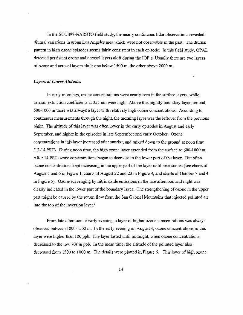
In the SCOS97-NARSTO field study, the nearly continuous lidar observations revealed
diurnal variations in urban Los Angeles area which were not observable in the past. The diurnal
pattern in high ozone episodes seems fairly consistent in each episode. In this field study, OPAL
detected persistent ozone and aerosol layers aloft during the IOP's. Usually there are two layers
of ozone and aerosol layers aloft: one below 1500 m, the other above 2000 m.
Layers at Lower Altitudes
In early mornings, ozone concentrations were nearly zero in the surface layers, while
aerosol extinction coefficients at 355 nm were high. Above this nightly boundary layer, around
500-1000 m there was always a layer with relatively high ozone concentrations. According to
continuous measurements through the night, the morning layer was the leftover from the previous
night. The altitude of this layer was often lower in the early episodes in August and early
September, and higher in the episodes in late September and early October. Ozone
concentrations in this layer increased after sunrise, and mixed down to the ground at noon time
(12-14 PST). During noon time, the high ozone layer extended from the surface to 600-1000 m.
After 14 PST ozone concentrations began to decrease in the lower part of the layer. But often
ozone concentrations kept increasing in the upper part of the layer until near sunset ( see charts of
August 5 and 6 in Figure 1, charts of August 22 and 23 in Figure 4, and charts of October 3 and 4
in Figure 5). Ozone scavenging by nitric oxide emissions in the late afternoon and night was
clearly indicated in the lower part of the boundary layer. The strengthening of ozone in the upper
part might be caused by the return flow from the San Gabriel Mountains that injected polluted air
into the top of the inversion layer.5
From late afternoon or early evening, a layer of higher ozone concentrations was always
observed between 1000-1500 m. In the early evening on August 4, ozone concentrations in this
layer were higher than 100 ppb. The layer lasted until midnight, when ozone concentrations
decreased to the low 70s in ppb. In the mean time, the altitude of the polluted layer also
decreased from 1500 to 1000 m. The details were plotted in Figure 6. This layer of high ozone
14

The most complicated multi-layer structures were observed on September 29 (Figures 13
and 14). It can be seen in Figure 13 that there were several layers below 1500 min the morning,
the uppermost two layers merged at 8 PST, and the lower layer merged with the boundary layer
at about 10 PST. Then the upper layer curved down and to some extent mixed with the lower
layer in the early afternoon, but the two-sublayer structure still remained. In the afternoon, the
two layers separated again. But only in the upper part were the ozone concentrations high. In
Figure 14, scanning data at about 0620, 0720, and 0820 PST were plotted to show the morning
structures in detail.
These multiple structures in the lower layer may be caused by complicated structure in
temperature profiles, as we saw in a previous experiment in the Los Angeles urban area (the
LARFS experiment in 1993, in Claremont, CA).8 They may also indicate complicated mountain
return flows. Apparently the middle layer at 1500 m in Figure 9 is not just above the boundary
layer, as modeled in Reference 5. The formation of polluted air in different layers in late
afternoon might be caused by return flows off mountains with different heights. These returns
flows may have different directions, because the mountains have slopes facing the sea-breeze and
sun at different angles. Thus, the complex layering structure of the atmosphere could also be a
result of the complex local and mesoscale meteorological processes.
17

(This page intensionally left blank.)
18

V. SUMMARY AND DISCUSSIONS
Layers of high ozone concentrations aloft in the South Coast Air Basin (SoCAB) in
California have been reported by many measurement projects. These layers may result from
complex mesoscale flows in the basin, including sea breezes and thermally forced daytime up
slope flow in the mountains.
It is hypothesized that these high-concentration ozone layers aloft may contribute
significantly to ozone standard exceedances in the basin by recycling pollutants from previous
days, and/or increase ozone concentrations in downwind basins by transport.4•5 During the 1987
Southern California Air Quality Study experiment, trajectory studies in two cases showed an
upper level recirculation in the middle of the SoCAB.6
During the SCOS97-NARSTO field study, NOAAIETL's OPAL detected persistent
ozone and aerosol layers aloft in the SoCAB. In most cases one layer was just above the top of
the marine boundary layer, the other was approximately at the altitudes of the mountain ridge line
north of the site. More complicated multi-layer structures were often observed in early morning
or in the evenings below 1500 m ms!. The co-location of the ozone and aerosol layers implies
that they probably originated from the same sources and processes. The modeling of Lu and
Turco in Ref. 5 has a transect line that passes near El Monte, i.e., A-A' [See APPENDIX B (a)].
The simulated ozone concentrations at three different times of the day are plotted in three figures
in APPENDIX B(b). These figures indicate the interactions between the sea-breeze and the San
Gabriel Mountains. Two layers of ozone are formed aloft from the return flows off the San
Gabriel Mountains: one layer was injected into the top of the inversion layer at about 1000 m, the
other comes from the mountain top and has its center located at about 2500-3000 m. At 1600
PST, the two layers can both be seen at a distance about 30 km from the coast. This is very
similar to what we observed at El Monte. However, lidar observations often detected a layer a
few hundred meters above the marine boundary layer, and sometimes with more complicated
structures. There might be multiple inversion layers ( or thermally stable layers) in temperature
19

profiles that cause this complexity. Return flows offmountain tops at different altitudes with
different azimuths might be another possible cause. Further analysis of the lidar data in
conjunction with meteorological data from the collocated RWPIRASS profiling system and air
quality data obtained from occasional aircraft spirals at El Monte should improve our
understanding of the atmospheric processes. Moreover, we strongly recommend, in the future, a
joint observation study of the powerful ETL Doppler lidar (i.e., the ETL's TEACO, which can
measure the 3-D wind field in a large area) and the ozone lidar. Working together, these remote
sensing technologies provide much more insight into the formation and evolution of polluted air
layers. These improved insights into the mechanisms and processes contributing to the
exceedance of the ozone standards in the SoCAB and surrounding areas will improve the
technical basis of attainment plans.
Ozone scavenging is indicated by the decrease of ozone concentrations mainly near
ground level. In the layers aloft, the trends of ozone concentrations and aerosol extinction
coefficients at 355 nm in the evenings were often opposite to each other: ozone concentration
decreased with time, while aerosol extinction coefficients at 355 nm increased. After sunset,
when the photochemical production of ozone stopped, the scavenging and dispersion processes
continued. N02 was created when ozone was scavenged by nitric oxide emissions. Various
nitrogen compounds (e.g., N02, N20 5) and radicals act as reservoirs of potential oxygen atoms
which are necessary for the formation of ozone. Any such compounds available in the following
morning would enhance ozone formation after sunrise. The increase of the 355-nm extinction
coefficient with time at night from the surface to 3 km may imply an increase in the aerosol size
due to the increase in relative humidity at night. Because 355 nm is close to the peak of an N02
absorption band, a portion of the increase in the extinction coefficient may also be attributed to
additional absorption by N02• However, the N02 absorption would only be about 10-20% of the
355-nm aerosol extinction coefficients, even ifwe assume N02 concentrations were as high as
100 ppb.
During daytime, ozone concentrations increased after sunrise in the boundary layer and
20

the layers aloft due to the photochemical processes that produce ozone. In the late afternoon
ozone concentrations decreased in the lower part of the boundary layer due to the scavenging by
NO and advection of cleaner air with the sea-breeze. Aerosol extinction coefficients at 355 nm
had similar temporal variations in daytime as that of ozone concentrations. The similar temporal
variations might be attributed to the production of smog aerosols in high ozone layers.
The continuous lidar observations during high ozone episodes in this field study provided
time variations of ozone and aerosol vertical profiles that have never been available previously.
Further analysis of the lidar data, combined with wind and other observational data, would
contribute significantly to the understanding of the formation and transport of the ozone layers,
and bring new insight into important issues in air quality research in Southern California.
21

(This page intensionally left blank.)
22

REFERENCES
1. E. M. Fujita, J. Bowen, M. C. Green, and H. Moosmuller (1997 draft), 1997 Southern
California Ozone Study (SCOS97) Field Study Plan. Report prepared by Desert Research
Institute for California Air Resources Board, Sacramento, CA. Contract No. 93-326.
2. Yanzeng Zhao, J. N. Howell, and R. M. Hardesty, "Transportable Lidar for the
Measurement of Ozone Concentration and Aerosol Profiles in the Lower Troposphere,"
A&WMA/SPIE International Symposium on Optical Sensing for Environmental
Monitoring, October 11-14, 1993, Atlanta, Georgia, pp.310-320.
3. Yanzeng Zhao, Richard D. Marchbanks, and R. M. Hardesty, "ETL's Transportable
Lower Troposphere Ozone Lidar and Its Applications in Air Quality Studies, " 42nd SPIE
Annual meeting, 31 July 1 - 1 August, 1997, San Diego, California, Application ofLidar
to Current Atmospheric Topics IL Proceedings ofSPIE #3127, pp.53-62.
4. J. L. McElroy and T.B. Smith, "Creation and fate of ozone layers aloft in southern
California," Atmospheric Environment 27A, No. 12, pp. 1917-1929 (1993).
5. R. Lu and R.P. Turco, "Ozone distributions over the Los Angeles basin: 3-dimensional
simulations with the SMOG model," Atmospheric Environment 30, No. 24, pp. 4155-
4176 (1996).
6. S. G. Douglas, R. C. Kessler, C. A. Emery, and J. I. Burtt, "Diagnostic Analysis of Wind
Observations Collected During the Southern California Air Quality Study," final report,
prepared under Contract No. A832- l 33 for California Air Resources Board, Sacramento,
CA, by Systems Applications International, San Rafael, CA ( 1991 ).
7. Y. Zhao, R. D. Marchbanks, C. J. Senff, H. D. Johnson, and Leon Dolislager, "Lidar
23

Profiling of Ozone and Aerosol in the SCOS97-NARSTO Experiment," 19th
International Laser Radar Conference, July 6-10, 1998, Anapolis, Maryland.
8. Yanzeng Zhao, John A. Gaynor, and R. Mike Hardesty, "Demonstration of a New and
Innovative Ozone Lidar's Capability to Measure Vertical Profiles of Ozone Concentration
and Aerosol in the Lower Troposphere," Final Report to California Air Resources Board,
Contract No. 92-328, December 1994.
24

GLOSSARY OF TERMS, ABBREVIATIONS, AND SYMBOLS
LIDAR
DIAL
RASS
RWP
NOAA
ETL
PST
AGL
MSL
Light Detection and Ranging (Lidar is a system that transmits laser beam(s) and
collects backscattered radiation through telescope(s). The received radiation is
then transferred to electronic signals by optical detectors. Since the backscattered
radiation from different distances has different time delays, the signal is range
resolved.)
Differential Absorption Lidar
Radio Acoustic Sounding System
Radar Wind Profiler
National Oceanic and Atmospheric Administration
Environmental Technology Laboratory (former Wave Propagation Laboratory)
Pacific Standard Time
Above Ground Level
Mean Sea Level
25

APPENDIX A
SCOS97's modeling domain of southern California and adjoining environs: an area of205,000 square kilometers (downloaded from the NOAA/ETL/ET4 web site). The lidar site was collocated with a RWP system at El Monte (No. 12 on the map).
26

APPENDIXB
Quotes from Reference 5: R. Lu and R.P. Turco, "Ozone distributions over the Los Angeles
basin: 3-dimensional simulations with the SMOG model," Atmospheric Environment 30, No. 24,
pp. 4155-4176 (1996).
(a) The model computation domain and topography
SI ~
g81~ :i SI
~
........
~
Pacific Ocean
120.00 119.50 119.00 118.50 118.00 117.50 117.00
LONGrruDE (W)
Fig. I. The model computational domain and lopography arc illustrated. The larger map defines the area over which mesoscale dynamical calculations are carried out. The inner perimeter indicates the domain used for the air quality (chemistry and microphysics) simulalions. Heavy solid lines indicate the coastline. Contour lines correspond to terrain elevations; the contour intervals are 200 m. The lines AA'. es·. CC.
DD' and EE' give the locations of the vertical cross-sections discuS5:Cd in the 1exr.
27

,., ,., -----------------s----, ,., ..,
,.. .., .., ,.,
g ).0
uI ,., ,., .. ,.,
APPENDIX B (Continued)
(b) The simulation result of ozone concentration along line A-A'
__... _(ba) ,.,
Fig. 4. Calculated ozone concentrations (contours. m intervals of 2 pphmv) for .a vcnicaJ cross•scction thal extends from Santa Monica Bay 10 the San Gabnel Mountains (AA' in Fig. I) on 27 August !987. The
topography is highlighted by scnping. (al 10:00 PST; (bl 14:00 PST.
..•
OJ
o.o L.L...-'-.::E::l...l.i...lr,,lm,:i!IJWIJ.UJ. ow»»~»~~~~~mmm~~~rnow»»e~~~~~~mm~~~~rn
Diaaooe doo,: lbe croa«dioa (tm) ,.,
s.s
s.o
4.S
g 4.0
3.S
3.0
! -8
2.S
2.0
l.S
1.0
o.s
0.0 0 10 20 30 40 50 60 70 80 90 100 110 120 130 140 ISO 160 170
Distance along the cross-section (km)
Fig. 6. Simulated ozone concentrations (contours. in intervals of 2 pphmvJ for vertical cross-section AA' (Fig. l)exlending [rom San1a Monica Bay to the San Gabriel Moun lams at 16;00 PST on 28 August 1987.
28

APPENDIXC
List ofLidar Operational Dates in SCOS97-NARSTO:
June 2-10, Set up and testing
June 11, 1997 - Intercomparison I
July 8, 1997 - Intercomparison II
August 4-6, 1997
August 22-23, 1997
August 24 (4 hours)
September 3 (4 hours) and September 5-7, 1997
September 27-29, 1997
October 3-4, 1997
29

APPENDIX D
(a) Schematic figure of the Iidar
Trunn.itter/ niccivcr
NOAA's Ozone Lidar
Torain.al
[!!] Com.p■ tcr •d Bloctronic1
30

APPENDIX D (continued)
(b) Optical layout in the transmitter and receiver
Optical Layout of the Modified Transmitter
Nd:YAGLucr
Dov.tDria.m lt.1111.u Cell With HD 111.d XD Lou
Optical Layout of the Detector Package
14J&¥J¥&L11 I
ksa it' · ··went t1r~· rto ttYtt I
31

APPENDIXE Analysis on the statistical error.in ozone concentrations
Ozone concentrations are calculated using Eq. (5) in Section II (The ETL Ozone Lidar) of
the final report. A differentiation of the logarithm ratio lnF(z) needs to be carried out
numerically. Ozone concentration is proportional to the slope of lnF(z), i.e., d lnF(z)ldz, which is
statistically estimated using least square methods. The following is a detailed derivation of the
variance and the standard deviation of the slope, and the resulting statistical errors in ozone
concentrations.
1. Linear least square fit
Using linear least square method to fit yin a range interval from z = z1 to z 2 , where
=z - k!iz, z 2 = z + kAz, z = + z 2 ) I 2 = Z;, the range at the jlh sample point, Az isz1 (z1
the range gate of the digitizer, and 2k+ I is the total number of sample points used in the least
square fit. The linear estimate of ln[F(z)], y, is a linear function ofrange z:
y = a+ b(z- z). (1)
The variance of the slope bis
s2(y) s2(y) s2(y)(j2 = k = k = k (2)2L(z;+J - z;)2 (Az)2 Lj2 2(Az)2I j
J=-k J=-k J=I
I k
where s2(y) is the variance ofy, defined as: s2(y) =-- '°'(Y . - y . . )2, where Y is the 2k - I ~ I+1 I+ 1
;=-k
data and y is the least square fit. Therefore, the root-mean-square of the slope bis
32

s(y)
(3)
It is proportional to the root-mean-square (standard deviation) ofy, and inversely proportional to
the standard deviation of the range. That means the accuracy of the estimate of the slope
increases with smaller standard deviation of noise and greater range interval.
2. Parabolic least square fit
The parabolic least square fit curve has the form
y = a+ b(z - z) + c(z - z)2. (4)
The slope dz at z = z= Z; is b, which can be calculated by the following equation:
~zLk
j[y(z;+)- y(z;_ 1 )] Lk
j[y(z;+J)- y(z;_)] = J=Ib = J=I ~------,-k---- (5)
2~zI j 2
J=I J=I
The variance of b is then
(6)
33

It is interesting to see that Eq. (6) is the same as Eq. (2), i.e., at z = z = Z; the variance
of the estimated slope has the same mathematical expression for linear or parabolic fitting.
However, with a better least square fit, the standard deviation ofy will be smaller and the slope
will have higher accuracy.
3. Error in the ozone concentration due to the statistical uncertainty of the slope
It is straightforward to calculate the statistical error in ozone concentration caused by the
uncertainty in the slope of ln[F(z)]. Using Eq. (5) in Section II of the final report, we can easily
obtain the standard deviation of ozone concentration
(7)
When estimating the error in ozone concentrations, we multiply a(p03) by a factor of2 to
have 95% of the error estimates within this range.
Implementing the equations in our programs but keeping the other parameters unchanged,
we reprocessed part of the data files on September 28, 1997, to obtain the statistical errors of
ozone as a function of altitudes at different times of the day when signal-to-noise ratios (SNR)
varied. In order to see the effect of decreased transmitted laser energy on the statistical errors in
ozone concentrations, a part of the data in the evening of August 4, 1997 was also reprocessed.
The statistical error will be higher when the signal is lower. As shown in Eq. (1) in
Section II, the signal P(z) is proportional to the atmospheric transmission (related to the
attenuation by ozone and aerosol), the aerosol backscattering coefficient, and the instrument
constant (which is proportional to the transmitted laser energy). The late September episode was
the last major IOP in the SCOS97 field campaign. The scanning mirrors were seriously damaged
by the pollution. The errors in ozone concentrations in the evening of August 4, 1997 (the first
day of the first major IOP) were two times smaller (less than 5 ppb throughout most of the
34

detection range) than those in the evening of September 28, 1997 ( compare Figure A and Figure
E). This implies an energy loss by a factor of about 4 due to the decrease of reflectivity in the
scanning mirror coatings. In fact, in the last day of the experiment, we took off the mirrors and
found that the signals immediately increased by a factor of 5. Therefore, the errors calculated for
data taken on September 28 should be the upper limits of those during the field study.
Errors in ozone concentrations at different altitude ranges at different times during the
day of September 28 ( especially those with higher errors) are listed in Table 1, and examples of
the error profiles are plotted in Figures A-E. The errors are low from late evening to the next
morning throughout the measurement range. At altitudes above 1000-1500 m, the errors increase
fast from mid morning to noon, reaching a maximum in early afternoon when ozone
concentrations in the boundary layer were highest for the day. During this short time period
(about one hour), ozone data above -1500 m have errors of approximately 25 ppb or more and
thus may not be usable. But in the boundary layer (below-1000 m), the statistical errors in
ozone concentrations remains less than 10 ppb.
Table l. Statistical error in ozone concentration retrieval from lidar data (E 1 d . 9/28/1997)xamp es unng
0054-0119 PST 1229-1259 PST 1327-1407 PST 1429-1454 PST 1729-1754 PST
MSL(m) 2o (ppb) MSL(m) 2o (ppb) MSL(m) 2o (ppb) MSL(m) 2o (ppb) MSL(m) 2o (ppb)
0-1000 2-5 0-1000 1-8 0-800 3-8 0-1000 1-8 0-1000 1-6
1000-1500 3-5 1000-1200 8-15 800-1000 8-23 1000-1500 6-10 1000-1500 2-6
1500-2000 5-9 1200-1600 15-20 1000-1500 20-25 1500-1700 15-20 1500-2000 6-12
2000-2500 7-11 > 1600 >25 >1500 >25 1700-1900 20-25 2000-2500 12-16
The low accuracy in high altitudes at noon time were primarily due to the low signal level
when laser beams and backscattered radiation traveled through a thick layer of high ozone
concentrations (about 200 ppb during that time period), and also may be due to the damage of the
scanning mirrors which remained in the polluted air of Los Angeles for four months. These
errors presented are among the worst during SCOS97. We are now improving the far-range
35

signals of OP AL by adding another wavelength. The range resolution will be lower as a trade
off for longer range ozone monitoring when ozone concentrations in the boundary layer are high.
2500
2000
g500 ..J en ~000
500
0 0
2500
2000
:[1500
..J en :i: 1000
500
0 0
Average STD of Ozone Concentrations 8/04/97 1744-1759 PST
5 10 2*STD (ppb)
Figure A
15
Average STD of Ozone concentrations 9/28/97 0054-0119 PST
5 10 2*STD (ppb)
Figure B
15
20
20
36

Average STD of Ozone Concentrations 9/28/97 1229-1259 PST
2500
2000
g500 . . ~
_J . (/J . _.:,-2000
..--V 500
~ 0
0 5 10 15 20 25 30 2*STD (ppb)
Figure C
Average STD of Ozone Concentrations 9/28/97 1429-1454 PST
2500
2000
E5oo _J
~000
500
0
" " " "
" -" " "
~~ 0
~
~ ~
5 10 15 20 25 30 2"STD (ppb)
Figure D
Average STD of Ozone Concentrations 9/28/97 1729-1754 PST
2500
2000
€500 _J
~000
500
0 200 5 10 15
2*STD (ppb)
Figure E
37

2500 ~~~~--------~--~~-OZONE MIXING RATIO (ppb)OZvru. rvi1/\11,,.,. ""' ,v \J-')-'U/
2500 -----1;--7 ~I • 20002000~
~
"1 ■ 1~2 1
j 15001 5r-r I l1
1
1
1~• 1000
- .... ' i
- -
$• 1000
i ~
,,' SOOr -r 500
1
oL -10 15 2010 15 20
Time {Hours PST}Time (Hours PST) FJ Monie. CA 6/ 5/ 97£1 Monte. CA 8/ 4/ 97
~ROSOL EXTINCTIO~~E~F"ICIENT .~! ~~? _n~ ~.O~ ~m) _ km·' AEROSOL EXTINCTION COEFFICIENT AT 355 nm (.01/km) _ km·•01 01 25 250083
o~--_,.---~~~-~---~~~
ao 77 74
'' 71
2000 65
59 56 " 53 i 150050 47 44 .s 41 38 35 32 29 26 23 20
1000 1000
500 17 500 14 11
' LJ ~ 0 10 15 20
Time (Hours PST} £1 Monte. CA 8/ 4/ 97
i 1500
5. 0
~
oc.....___,.____,__~--'----'----'-_,_J
ppb
0 5 10 15 ,o Time (Hours PST)
El Monte. CA 8/ 6/ 97
ii I i1
r--
°' °'-'D
I 'tj-._. <f)
5'o ~ ...... 0
.g 0 <f) ·s.. <l.l <l.l -5 bl) C
·;:: .g 0 <fl
8 1;J
ifiatit" ~ ti,,,..., 7 83 2soo~:w■■■■■■■llil■■■■■ -.-.-,
1500
n~
ao 83 §80
77 77 74 <l.l74 71 71 C
0 65
059 59" "
56 " ••65
...... N
56 53 j 53 0 50 50 <f)47 47
1a44 5 44 41 38 35 " 38 ..c:
35 u32 32 29
26 2623
29
"fili23 20 20 17 1714 ]
14 11 11 8 8 5 5 2 2 ~
IO 15 20 10 15 20 r;me (Hours PST) Time (Hours PST)
~ El Monte. CA 8/ 5/ 97 Et Monte. CA 8/ 6/ 97
oilrr:
AEROSOL EXTINCTION COEFFICIENT AT .355 (.01/km) .o, km·• "O

ppb 162500 -- -ii ,. 2ooor •l
1 1 11 11
'·~t -· -Ii1000 l'1
soor
80 0 5 10 15 20 -
Time (Hours PST) Fl Monte. CA 9/ 5/ 97
:a~ROSOL EXTINCTION COEFFICIENT AT 355 nm (.01/km) .o, i.:m·• 2 83
BO 77 74 71
2000 68 65 62 59 56 SJi 1500 50 47 44..s 41 36~ 35';: 1000 32< 26 " 23 20
500 17 14 11 6 5
o~~~~~--~~~~~~~~~~~ l_J 2 10 15 20
Time (Hours PST) El Monte. CA 9/ 5/ 97
ppb 165~2500
14 1 1 1iil1 11 10 1i 1500
!;~8..s
~
~
500 Il! 0
5 10 15 20 Time (Hours PST)
Et Monte. CA 9/ 6/ 97
::~=iiiii~,,••I•••li ~ "56
~1500 ' ::" i~ E • • I 44
.._, ; 411,-1 IM_JI ~1111,~ !9! i -
.. !I 26 23 20
500r 1714 11
•5 OL..~~'-'~---'-~~~--'--~~.,__,~~ l_J 2
O 5 10 15 20 Time (Hours PST)
El Monte. CA 9/ 6/ 97
OZONE •t1~ING RATIO (ppb) 2500
2000
i 1500
..s ~ ~ 1000 <
soo
0 0 5 10 15 20
Time (Hours PST) El Monte. CA 9/ 7 / 97
AEROSOL EXTINCTION COEFFICIENT AT 355 nm (.01/km) 2500~
2000
i 1500
.§,
1000
500
10 15 20 Time (Hours PST)
El Monie. CA 9/ 7/ 97
ppb 656gig
I4i
lg i~
J~
'! 4~
0
_ km·'01 _ 83
60 77 74 71 68 65 62 59 56
.. SJ 50 47
41 38 35 32 29 26 23 20 17 14 11•5 2
...... °' ~
r-1
(")
s .... V
~ V
(/)
"o .g 0 <JJ
"fr -s Oil s::: ·c .g 0
<JJ
8 ~
"O §
1:l 0 N 0
"o <JJ
l;i..c: u ...,..c: .a)Oil
..c:
~ ~ N
t,i)
ti:
0

AEROSOL EXTINCTION COEFFICIENT AT 355 nm (.01 /km) _ km·'~ROSOL EXTINCTION COEFFICIENT AT 355 nm {.01 /km) .ot km-' AEROSOL EXTINCTION COEFFICIENT AT 355 _nm _(:01/km) 01 km·' 01 2500 r iiii!'l- · I - 63 :J
2500 ppb lll
20002ooor- -·1~ 1500 j 1500
0 t -'-.i1000 11~ S .
1000
"ii 5oor -■-I' : ij
500
0 0 10 15 20 0 5 10 15 20
Time (Hour:i PST) Time (Hours PST) El Monte. CA 9/27 / 97 El Monte. CA 9/28/ 97
2
2000
i 1500
-'-~ :Z 1000
"
500
o~~~~~--~~~~~-~~~~~ 10 15 20
Time (Hours PST) Er Monte. CA 9/27 / 97
BJ "ift"iif- """j,I~ , ~.7 , 2soo~·~-,~~;,··~ _ "Cl BO BO 77 77 §77
74 71 71 74
71 <l) SB 20001 i 6B 2000
" 6B C65 62 62 55 65
62 0 59 59 59 N 56 56 56 0
5353 53 4-<i 1500 .. 5050 50 04747..., . " 44 -'-,. JBJB ~ ~ " 3535 ~ 1000 35 ~ 1000 32
" ]32 32
29 (.)
26 26 29 " 29 "
" 26
17 -§i2020 20
17 17 " " 500 500 14 ,. 14 -~
1111 11 ..cB 5 5 B B
5 2 2 2 ~
~ C'"l
ob ~
10 15 20 Time (Hours PST}
El Monte. CA 9/29/ 97
10 15 20 Time (Hours PST)
El Monte, CA 9/28/ 97
ppb 2500
ff H
2000
1500I i,
ii14
-'-~ ~ 1000
71 "
It 500
1, 0 0 5 10 15 20
Time (Hours PST) El Monte. CA 9/29/ 97
t---0\
-< °' ppb N °' I I I ~
~
"s .... <l)
i Cl) .... 0
.g 0 "' ·a <l)
-s 00 C·c:: .g 0 "' ~

OZONE MIXING RATIO~ .. ~·~ ppb ppb180 2500 180 174 168 162 156 150 144 138 132
r=r 11 Im 126
108 vi' 102 96 " 90
_§, 84 . 78 ]
"' 1000 72 ~ 66 ~
-48
60 54
36500f- --1 42
30 24 18 - 12 6
0 I 0
2500
2000
~ 1500
_§,. u ;E l000 <
AEROSOL EXTINCTION COEFFICIENT AT 355 nm (,01/km) km·• AEROSOL EXTINCTION COEFFICIENT AT 355 nm (.01 /km) km-•
;,>re 1'
2 0 5 10 15 20 0 5 10 15 20 ob
Time {Hours PST) TTme (Hours PST) ti: El Monte. CA 8/22/ 97 El Monte. CA 8/23/ 97
0L...~~~...L.~~~--'-~~~"--"L...~~~~~~~ L_J 2
01 012500~. i'-~ - _.---,--- . 122 "O
.... ., _ ~- -, l m 118 §114I 110 0
106 1M i= 102 1m 02000 % N98 94 M 0 90 ~ '+-< 82 86 ~ 0
m ~ cJ)78 N74 i 1500
70 ro ~ ~66 _§, ..c:: ~ u62 . ~58 u54 ~50 ~ 1000 M -§i
46 ~Ill < ~42'<I ]~38
34 ~
n ~ ~ 30 ~26 500►
22 18
■ 18
14 14 ~ 1010
-- a 6 6 'SI"
174 168 &;162 156 ,-;150 "' 144
(")-. 138 N132
126 I N120
114 N 108 ...
cJ)102 96 §i90 84 78 ~ 72 66 '+-< 60 054 48 42 ~ 36 0
cJ)30 24 18 .fr 12 6 £0
OJ) i=·.:: .g 0
cJ)
8 ~
500

ppb 150 145 140 135 130 125 120 115
105
;I95
i,--I
90 85 80.·~r
110
100
75 70 65
-40
50
60 55
45
35 500f"- 30
25 20 15 - 10 5
0 0_J
0 5 10 15 20 Time (Hours PST)
El Monte. CA 10/ 3/ 97
AEROSOL EXTINCTION COEFFICIENT AT 355 nm (.01/km) 01 km·' 2500 152
147 142 137 132
2000'
. T " ~1Jit~ . . 127
122 117 112 107 102
-::; 97 92 87 82
~ 1500
5 77. 72 67u 62-~ 1000 57 52 " 47 42 37
500 32 27 22 17 12 7
0 2 5 10 15 20
Time (Hours PST) El Monte. CA 10/ 3/ 97
2500
2000
i 1500
-. E
u
~ 1000
"
500
0
2500
2000
f -::; rg 1500
5. u
~ 1000
"
500
0 0
0 5 10 15 20 Time (Hours PST}
El Monte. CA 10/ 4/ 97
AEROSOL EXTINCTION COEFFICIENT AT 355 nm (.01 /km) •r-.,-~~~
·, ~ ~~\.~;~·?.ii· 1~1f/f"~~:• ' t' . ·/' (, iii ~ '-- .• ,..., .. •---• • a i.
5 10 15 20 Time (Hours PST)
El Monte. CA 10/ 4/ 97
ppb 150 145 140 135 130 125 120 115 110 105 100 95 90 85 80 75 70 65 60 55 50 45 40 35 30 25 20 15 10 5 0
01 km·'• 152
147 142 137 132 127 122 117 112 107 102 97 92 87 82 77 72 67 62 57 52 47 42 37 32 27 22 17 12 7 2
&; .-< °' "t r'l ... <I)
.g 8 ._ 0
~ 0 "' ·a <I)
<I)
.s t>J)c::
"§ -0
0 "' 8 ~ -0 § <I)c:: 0 N 0 ._ 0
"' 'g ..c:: u
.1:: ] t>J)
~ ~ \r)
t,() ii;
0

OZONE MIXING RATIO (ppb) 2500 rT"li-iiiii ppb 170
165 160 155 150 145
2000 140 135 130 125 120
'.:i' (/) ::;
s Cll -a .a :;, <(
1500
1000
;,. 115110 105 100 95 90 85 80 75 70 65 60 55 50 45 40
500 35 30 25 20 15 10 5 0
17 18 19 20 21 22 Time (Hours PST)
El Monte. CA 8/ 4/ 97
AEROSOL EXTINCTION COEFFICIENT AT 355 nm (.01 /km~ 1 km_,
2500 · 62 60 58 56 54 522000 50 48 46 44 42
'.:i' 40(/) 1500::; 38
36 E 34
32 -a Cll 30
28 ~ 1000 26 <( 24
22 20 18 16 14 12 10 8 6 4 2
17 18 19 20 21 22 Time (Hours PST)
El Monte. CA 8/ 4/ 97
Fig. 6 Time-height charts of ozone concentrations and aerosol extinction coefficients in the evening of August 4

OZONE MIXING RATIO (ppb)
21.35 21.40 21.45 Time (Hours PST)
El Monte. CA 8/ 4/ 97
AEROSOL EXTINCTION COEFFICIENT AT 355 nm (.01 /km~ km- 1
21.30 21.35 21.40 21.45 21.50 Time (Hours PST)
El Monte. CA 8/ 4/ 97
Fig. 7 Time-height chart of ozone concentrations and aerosol extinction coefficients during one scanning at about 2120 PST on August 4, 2997
2500
2000
~ _J
<fl 1500::;;
sS ., -0
.3 1000:;:; <(
500
ppb 135 130 125 120 115 110 105 100 95 90 85 80 75 70 65 60 55 50 45 40 35 30 25 20 15 10 5 0
12500 .
2000
~ _J
<fl 1500::;;
sS ., -0
.3 1000:;:; <(
500
62 60 58 56 54 52 50 48 46 44 42 40 38 36 34 32 30 28 26 24 22 20 18 16 14 12 10 8 6 4 2

Fig. 8 Time-height charts of ozone concentrations and aerosol extinction coefficients from late afternoon to evening on September 5, 1997
OZONE MIXING RATIO (ppb) 2500
2000
~
_j
U1 1500::;;
s (l)
-0
.2 :;:; 1000 <i'
500
AEROSOL 2500
2000 I
'.::j' U1 1500::;;
s (l)
-0
~ 1000 <i'
500
16 18 20 Time (Hours PST)
El Monte. CA 9/ 5/
EXTINCTION COEFFICIENT AT
,,,.,..
16 18 20 Time (Hours PST)
El Monte. CA 9/ 5/
22
97
355 nm
22
97
ppb 105 100 95 90 85 BO 75 70 65 60 55 50 45 40 35 30 25 20 15 10
5 0
km_, 86 83 80 77 74 71 68 65 62 59 56 53 50 47 44 41 38 35 32 29 26 23 20 17 14 11 8 5

2500 OZONE
:rrr-......acr.r: MIXING RATIO (ppb)
p-,---..--r-.-.. ppb
90
85
80 2000 75
70
65
-::,- 60 U1 ::. 1500 55
-S 50
Q) 45 "O
.3
.;:; ;;'
1000 40
35
30
25
500 20
15
10
5
0 17.60 17.70 17.80 17.90 18.00 18.10
Time (Hours PST) El Monte. CA 9 / 5/ 97
AEROSOL EXTINCTION COEFFICIENT AT 355 nm (.01 /kmti1 km-1
2500 · 25 24 23 22
2000 21 20 19 18 17~
_J
U1 1500 16 ::. 15
-S 14
Q) 13 "O 12 .3 ·.;:; 1000 11 ;;' 10
9 8 7
500 6 5 4 3 2 1
17.60 17.70 17.80 17.90 18.00 18.10 Time (Hours PST)
El Monte. CA 9/ 5/ 97
Fig. 9 Time-height chart of ozone concentrations and aerosol extinction coefficients during one scanning at about 1800 PST on September 5, 1997

3000 OZONE MIXING RATIO (ppb)
ppb 135 130 125 120 115 110 105 100
,=, (/]
:::.
2000 95 90 85 80
E 75 70
" 65 -0
.3 :;:;
60 55
<( 50 1000 45
40 35 30 25 20 15 10 5 0
17.5 18.0 18.5 19.0 Time (Hours PST)
El Monte. CA 9/28/ 97
km_, 66 64 62 60 58 56 54 52 50 48
2000 46 44 42 40 38 36 34 32 30 28 26 24 22 20 18 16 14 12 10 8 6
17.5 18.0 18.5 19.0 Time (Hours PST)
El Monte. CA 9 /28 / 97
Fig. 10 Time-height charts of ozone concentrations and aerosol extinction coefficients in the evening on September 28, 1997

OZONE MIXING RATIO (ppb)
17.30 17.32 17.34 17.36 17.38 17.40 Time (Hours PST)
El Monte. CA 9 /28 / 97
AEROSOL EXTINCTION COEFFICIENT AT 355 nm (.01/km km- 1613000
2000 42-:;- 40 ::, 38
36
(/)
-S 34 32
"O"' 30.2 .;:; 28 :;;: 26
1000 24
3000
2000 ~
_J (/) ::,
-S " "O
.2 ·.;:; :;;:
1000
ppb 135 130 125 120 115 110 105 100 95 90 85 80 75 70 65 60 55 50 45 40 35 30 25 20 15 10 5 0
60 58 56 54 52 50 48 46 44
22 20 18 16 14 12 10 8
0 6
17.30 17.32 17.34 17.36 17.38 17.40 Time (Hours PST)
El Monte. CA 9/28/ 97
Fig. 11 Time-height chart of ozone concentrations and aerosol extinction coefficients during one scanning at about 1720 PST on September 28, 1997

'.:J' V1 ~
~ " " 3
:.::, ;;'
3000
2000
1000
0 '--'-.L......~...L_L....L~-'-----"~~.L.....L~...L_L....L~_,___.~~.L.....L~--'-----"
ppb 135 130 125 120 115 110 105 100 95 90 85 80 75 70 65 60 55 50 45 40 35 30 25 20 15 10 5 0
18. 18 18.20 18.22 18.24 18.26 18.28 18.30 Time (Hours PST)
El Monte. CA 9/28/ 97
AEROSOL EXTINCTION COEFFICIENT AT 355 nm (.01 /km61 km-•
18. 18 18.20 18.22 18.24 18.26 18.28 18.30 Time (Hours PST)
El Monte. CA 9 /28 / 97
~ _J
V1 ~
~ " " 3
:.::, ;;'
3000 - -,. •. - .
2000
1000
0---'-~~~~~~~...L_~~~~~~~...L_~~~
66 64 62 60 58 56 54 52 50 48 46 44 42 40 38 36 34 32 30 28 26 24 22 20 18 16 14 12 10 8 6
Fig. 12 Time-height chart of ozone concentrations and aerosol extinction coefficients during one scanning at about 1820 PST on September 28, 1997

2500
2000
~ _j (/] 1500:::;;
sS " "O
~ 1000·.;, <(
500
ppb 170 165 160 155 150 145 140 135 130 125 120 115 110 105 100 95 90 85 80 75 70 65 60 55 50 45 40 35 30 25 20 15 10
8
OZONE MIXING RATIO (ppb)
6 8 10 12 14 16 18 Time (Hours PST)
El Monte. CA 9 /29 / 97
AEROSOL EXTINCTION COEFFICIENT AT 355 nm 2500 J-
~ _j (/]
:::;;
sS " "O
2000
2 1000 ~
500
km- 1
83 80 77 74 71 68 65 62 59 56 53 50 47 44 41 38 35 32 29 26 23 20 17 14 11 8 5 2
6 8 10 12 14 16 18 Time (Hours PST)
El Monte. CA 9 /29 / 97
Fig. 13 Time-height charts of ozone concentrations and aerosol extinction coefficients September 29, 1997

500
OZONE MIXING
I ppP
2500 55 50 55 50 45
~~ 2000
'" 15 10 05
~, 1500 00 cl,95
..s 90 85 ..s BO . u, 75 u,70
; 1000 55 60 ~< 55 50 45 ~g
15 10 5 0
6.JO 6.J2 6.34 6.36 6.38 6.40 6.28 6.30 6.32 6.34 6.36 5.38 6.40 Time (Hours PST) Time (Hours PST)
El \tonte. CA 9 /29 / 97 El Monte. CA 9/29/ 97
OZONE MIXING RATIO (pobl
I ppb
i65 i70
160 155:ig140 1~51 0 1 5 120 115 110 105 100 95 90 '5 ~Q
l5 15 10
6
Fig. 14 Time-height charts of ozone concentrations and aerosol extinction coefficients in three scanning operations at about 0620, 0720, and 0820 PST on September 29, 1997
2500
2000
~
~ 1500
..s
t 7.30 7.32 7.34 7.36 7.38 7.40 7.30 7.32 7.34 7.36
Time {Hours PST) Time (Hours PST) El ~Onie. CA 9/29/ 97 El ~onte. CA 9/29/
OZONE" MIXING R.'1'0 ( cpb)
I ppb
2500 155 150 145 140 135 130
2000 125 120 115 110 :os 100 95 90 '5 BO. 75
u, 70 65
~ 1000 60 55 50 45 40 35 30 25 20 15 10 5 0
8 ..30 8.32 8.34 8.J6 8.38 8.28 8.30 8.32 8.34 8.36 Time (Hours PST) Time (Hours PST)
El ~orile. CA 9/29/ 97 El ~ante. CA 9/29/
. u,
AERCSOL ':XTINCTIQN CoEi=-FICIE\IT A.T 355 "'TI
2500
2000
-~ 1000
500
7.38 7.40
97
8.38 8.40
97


![Detecting the recovery of total column ozone · ozone layer since the 1970s [World Meteorological Organization (WMO), 1995, 1999; Farman et al., 1985]. International legis- lation](https://static.fdocuments.in/doc/165x107/605b5db0830a7954b3404a45/detecting-the-recovery-of-total-column-ozone-ozone-layer-since-the-1970s-world.jpg)