Regional Watershed Management in Louisiana
86
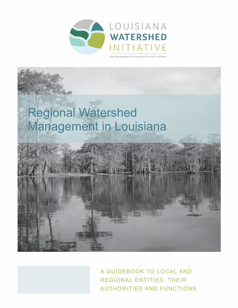
Regional Watershed Management in Louisiana A GUIDEBOOK TO LOCAL AND REGIONAL ENTITIES, THEIR AUTHORITIES AND FUNCTIONS
Transcript of Regional Watershed Management in Louisiana
Regional Watershed Management in Louisiana
A GUIDEBOOK TO LOCAL AND REGIONAL ENTITIES, THEIR AUTHORITIES AND FUNCTIONS

2
REGIONAL WATERSHED MANAGEMENT IN LOUISIANA
A GUIDEBOOK TO LOCAL AND REGIONAL ENTITIES, THEIR AUTHORITIES AND FUNCTIONS
LOUISIANA WATERSHED INITIATIVE
Contents
Introduction: Louisiana Watershed Initiative . . . . . . . . . . . . . . . . . . . . . . . . . . . . . . . . 3
Guidebook purpose and background . . . . . . . . . . . . . . . . . . . . . . . . . . . . . . . . . . . . . 4
The landscape of watershed management in Louisiana . . . . . . . . . . . . . . . . . . . . . . . 5
Watershed management entities in each provisional watershed region . . . . . . . . . . . . 9
Region 1 . . . . . . . . . . . . . . . . . . . . . . . . . . . . . . . . . . . . . . . . . . . . . . . . . . . . . . . . . 10
Region 2 . . . . . . . . . . . . . . . . . . . . . . . . . . . . . . . . . . . . . . . . . . . . . . . . . . . . . . . . . 19
Region 3 . . . . . . . . . . . . . . . . . . . . . . . . . . . . . . . . . . . . . . . . . . . . . . . . . . . . . . . . . 28
Region 4 . . . . . . . . . . . . . . . . . . . . . . . . . . . . . . . . . . . . . . . . . . . . . . . . . . . . . . . . . 36
Region 5 . . . . . . . . . . . . . . . . . . . . . . . . . . . . . . . . . . . . . . . . . . . . . . . . . . . . . . . . . 46
Region 6 . . . . . . . . . . . . . . . . . . . . . . . . . . . . . . . . . . . . . . . . . . . . . . . . . . . . . . . . . 57
Region 7 . . . . . . . . . . . . . . . . . . . . . . . . . . . . . . . . . . . . . . . . . . . . . . . . . . . . . . . . . 66
Region 8 . . . . . . . . . . . . . . . . . . . . . . . . . . . . . . . . . . . . . . . . . . . . . . . . . . . . . . . . . 75
Statewide gap analysis . . . . . . . . . . . . . . . . . . . . . . . . . . . . . . . . . . . . . . . . . . . . . . 83
Watershed management entities statewide . . . . . . . . . . . . . . . . . . . . . . . . . . . . . . . 84

3
REGIONAL WATERSHED MANAGEMENT IN LOUISIANA
A GUIDEBOOK TO LOCAL AND REGIONAL ENTITIES, THEIR AUTHORITIES AND FUNCTIONS
LOUISIANA WATERSHED INITIATIVE
Introduction: Louisiana Watershed Initiative
LOUISIANA’S FLOOD RISK IS CHANGING
Flash flooding is on the rise, resulting in rivers spilling over their banks and into our communities more frequently . The widespread disaster of the Great Floods of 2016 demonstrated how susceptible our landscape is to severe flooding. In fact, over the past two decades, Louisiana has experienced 16 declared flood- and hurricane-related disasters. Every parish in the state has been impacted by one or more of these events, costing more than $16 billion in public assistance .
The Great Floods of 2016 also demonstrated that Louisiana has to take a new approach to managing our flood risk because continuing with business as usual will not address the problem. It is clear that our state’s prospects—our safety, our economy and the preservation of our places and culture—depend on managing and reducing our flood risk. It is also widely acknowledged that while Louisiana communities and agencies have already taken steps to address flood risk, our efforts have not been as coordinated and integrated as we need them to be . Our state agencies, programs and policies have not been as aligned as they should be, and local governments have not had enough of a platform to coordinate with neighboring jurisdictions to understand how their actions can impact one another . Furthermore, the information and data needed to make sound decisions have not always been readily available, accessible or communicated to the public, stakeholders or decision-makers.
THE OPPORTUNITY OF REGIONAL WATERSHED MANAGEMENT
To address these challenges, Gov . John Bel Edwards created the Council on Watershed Management and tasked it with developing a framework that aligns state and local agencies to institute best practices in reducing flood risk. The Louisiana Watershed Initiative is the council’s programmatic arm through which floodplain management responsibilities are coordinated among federal, state and local agencies. LWI’s work is supported by experts who will build a foundation of data, projects, policies, standards and guidance . To successfully implement these efforts, the state is developing processes that facilitate coordination among local, regional and state government agencies . Because water does not follow political boundaries, it is imperative this regional coordination align with watershed boundaries, not political jurisdictions .
LWI developed the Regional Capacity Building Grant program to provide resources that support regional watershed management . The goal is for local and regional stakeholders to work with state agencies to codesign an effective system of regional watershed management and governance . This guidebook is part of the suite of tools and resources that stakeholders can use in the development and deliberation of regional watershed management entities .

4
REGIONAL WATERSHED MANAGEMENT IN LOUISIANA
A GUIDEBOOK TO LOCAL AND REGIONAL ENTITIES, THEIR AUTHORITIES AND FUNCTIONS
LOUISIANA WATERSHED INITIATIVE
Guidebook purpose and backgroundThis guidebook is an educational tool and reference guide for members of the eight regional steering committees and other stakeholders participating in the RCBG program under LWI . It provides background information on the existing entities in each region and the state that perform watershed management functions .
LWI developed the guidebook to serve two primary purposes:
1. A briefing document that provides background to watershed coordinators, regional steering committee members and other stakeholders as they deliberate best approaches to regional watershed-based floodplain management
2 . A comprehensive reference document to inform regional steering committees and future regional watershed coalitions of all organizational stakeholders in the region and their statutory powers relative to watershed and floodplain management
Stakeholders in each region can directly reference their regional details, but readers also are encouraged to explore the similarities and differences among regions. A statewide summary of local and regional entities is provided at the end of the document . This guidebook complements a series of exercises the regional steering committee members and other stakeholders will undertake to explore different approaches to regional watershed management .
These exercises have two main objectives:
1 . Build a common understanding of what a regional watershed management entity should accomplish and identify the key responsibilities at the local, regional and state levels to help achieve the shared goal of reduced risk through watershed-based floodplain management
2 . Identify gaps and opportunities in watershed management in each region and recommend strategies for establishing a regional watershed coalition and policies designed to improve water management at the local, regional and state levels
The feedback and outcomes of these exercises will inform the development of a statewide framework for regional watershed management . That framework may include state and local legislative efforts to better align the functions of watershed management with watershed boundaries . The feedback will also inform the design of state and local policies and funding programs to produce better outcomes in each watershed throughout the state .

5
REGIONAL WATERSHED MANAGEMENT IN LOUISIANA
A GUIDEBOOK TO LOCAL AND REGIONAL ENTITIES, THEIR AUTHORITIES AND FUNCTIONS
LOUISIANA WATERSHED INITIATIVE
The landscape of watershed management in LouisianaFlood risk involves several interrelated factors—from land use and development to the maintenance of waterways and the design of flood control infrastructure—and many governmental entities and political subdivisions play significant roles in flood risk and floodplain management. Beyond the state and federal agencies that regulate and oversee aspects of flood risk and/or floodplain management, many of Louisiana’s local and regional entities and special purpose organizations also touch water management in some way . In fact, if you consider all the entities that have roles in managing water resources, even for purposes of navigation (e.g., ports) or freshwater and/or groundwater management (e .g ., water districts), there are more than 2,000 entities that impact water management on the federal, state and municipal levels in Louisiana. However, this document focuses on entities with the specific authorities and functions most integral to regional watershed management .
Even with this narrower focus, there are still many entities with influence and responsibility, which has resulted in a complex, uncoordinated landscape of watershed management throughout the state. Many entities have overlapping authorities and jurisdictions, and many have presences in more than one watershed region. Meanwhile, some areas of the state lack an entity with specific authority over water management. The following table lists various types of entities with influence over water management and flood risk reduction, their enabling laws and their missions and authorities.

6
REGIONAL WATERSHED MANAGEMENT IN LOUISIANA
A GUIDEBOOK TO LOCAL AND REGIONAL ENTITIES, THEIR AUTHORITIES AND FUNCTIONS
LOUISIANA WATERSHED INITIATIVE
Regional steering committees underwent a significant effort to evaluate best practices and gather feedback from regional stakeholders to identify the potential powers and authorities that a regional watershed coalition may need to support effective watershed-based floodplain management. These functions and authorities are listed below .
DESIRED FUNCTION REQUIRED AUTHORITY
Flood analysis, mapping and data None
Floodplain and development codes and enforcement Develop and enforce codes
Land use planning and development review Adopt plans and regulate development
Fund and implement flood risk reduction projects Generate revenue, borrow money, select projects and acquire property
Operation and maintenance of flood risk reduction infrastructure Generate revenue and acquire property
Public education, engagement and communication None
Not all of these functions require additional authority. For example, education, engagement and communication are functions a regional coalition can immediately implement without any additional authority .
Also, an entity may already have the authority to serve a desired function but not have the capacity to implement it . This guidebook does not analyze the capacities of existing entities in each region, but this aspect should be considered when regional steering committees form recommendations for regional governance .
The following chapters describe the landscape of entities in each watershed
region that possess some authority to impact water management or flood risk. As part of the regional exercises, state agencies and
regional stakeholders will compare the types of entities in each region against the desired
authorities listed above, thus beginning to identify gaps in governance that may need to be addressed by a regional watershed
coalition .

7
REGIONAL WATERSHED MANAGEMENT IN LOUISIANA
A GUIDEBOOK TO LOCAL AND REGIONAL ENTITIES, THEIR AUTHORITIES AND FUNCTIONS
LOUISIANA WATERSHED INITIATIVE
CATEGORY DESCRIPTION OF ENTITY ENABLING LAW
Gravity Drainage Districts
Gravity drainage districts facilitate water management by draining district lands through the construction, maintenance and operation of gravity or forced drainage facilities, including drains, drainage canals, ditches, pumps, pumping plants, dikes, levees and other related works. Each parish except Orleans has the statutory authority to create gravity drainage districts and gravity sub-drainage districts, as necessary . Each parish governing authority may determine the number of gravity drainage districts required in the parish . A board of commissioners governs each gravity drainage district, with members appointed by the parish governing authority based on the petition or recommendations of surrounding landowners .
La . R .S . 38:1751-1904; authorizing parishes to create gravity drainage districts
Levee Districts
Levee districts seek to understand the dynamics of flood protection and tidal surge specific to a prescribed area in order to establish a plan for protection in conjunction with neighboring parishes, determine funding sources and implement the plan . Levee districts are political subdivisions of the state, designated in the Louisiana Constitution and formed by the Legislature . Levee districts have taxation, bonding and expropriation powers within their territories.
La . Constitution Article 6, Sec . 38; La . R .S . 38:291; levee districts
Floodplain Administrators
Almost every parish and municipality in Louisiana has adopted a local ordinance to establish a local floodplain administrator within government, such as the chief building official, who will fulfill the associated duties, which include compliance with federal legislation at the local level . However, passing a local ordinance does not mean that the parish or municipality has dedicated staff or resources to perform these functions nor does it mean a local government is in compliance with federal law .
La . R .S . 38:84, et seq.; power to comply with federal Flood Insurance Act and as dictated by local ordinance
Planning and Development Districts
A planning district is a multiservice entity with state-defined boundaries that delivers a variety of federal, state and local programs and offers services such as technical assistance and professional planning services to its regions . Louisiana’s planning and development districts are on the front lines of community-based economic development and resilience, with long-established relationships with the U .S . Economic Development Administration . These entities are created with the statutory purposes of making parishes and municipalities in the districts more economically self-reliant.
La . R .S . 33:9039 .101, et seq.; and as created or recognized by local ordinance
Planning Commissions
Planning commissions are charged with creating a master plan for the physical development of a subject territory to promote the health, safety, convenience, morals and general welfare of the community . The master plan should ensure orderly development of property by establishing adequate standards for the provision of air, light and open spaces; providing for the proper arrangement streets and traffic circulation; and ensuring adequate parking, utilities and zoning to encourage the most appropriate use of land . Importantly, planning commissions often provide instruction to avoid flood risk that results from overburdened storm drainage systems and flood plains.
La . R .S . 33:101 et seq.; and as set forth by local ordinance .

8
REGIONAL WATERSHED MANAGEMENT IN LOUISIANA
A GUIDEBOOK TO LOCAL AND REGIONAL ENTITIES, THEIR AUTHORITIES AND FUNCTIONS
LOUISIANA WATERSHED INITIATIVE
CATEGORY DESCRIPTION OF ENTITY ENABLING LAW
Recreation and Water Conservation Districts
Recreation and water conservation districts are political subdivisions of the state, with the purpose to preserve, promote and develop the wealth and natural resources of the district through the conservation of the soil and water for agricultural, recreational, commercial and sanitary purposes and the regulation of aquatic plant growth .
Individually created by Title 38
Reservoir Districts
Reservoir districts are formed for the purpose of the development of the wealth and natural resources of the district by the conservation of soil and water for agricultural, recreational, commercial, industrial and sanitary purposes . This includes, for example, the creation and maintenance of a lake within the district. The Louisiana Department of Transportation and Development manages reservoir districts .
Individually created by Title 38
Soil and Water Conservation Districts
The farm and grazing lands of the state are among its basic assets, and the preservation of these lands is necessary to protect and promote the health, safety and general welfare of its citizens . The state's 44 SWCDs are charged with assisting the state's farmers and ranchers in implementing conservation practices to protect and enhance the soil, water and related resources of the state . The SWCDs work independently but with guidance from the National Resources Conservation Service .
La . R .S . 3:1201; Soil and Water Conservation Districts
Watershed Special Districts
Watershed special districts are political subdivisions of the state, with specific enacting legislation and a state budgetary unit . These watershed districts aim to conserve the soil and water within designated areas; develop the natural resources and wealth of the district for sanitary, agricultural or recreational purposes; and provide flood protection and control. The districts have a significant amount of authority to accomplish their purposes.
Individually created by Title 38
Waterway Special Districts
Waterway special districts seek to improve and maintain navigation of waterways in designated areas, usually including repairs, improvements and maintenance required to support navigable waters . The preservation of these navigable waters promotes economic development, proper irrigation, improved water supply, proper drainage, public recreation and hydroelectric power opportunities for Louisiana citizens .
Individually created by Title 34
Coastal Zone Management Programs
The Louisiana Department of Natural Resources funds local coastal zone management programs . DNR, in cooperation with the National Coastal Zone Management Program, has provided grants to Louisiana parishes in the coastal zone . Parishes may apply for funding for the preparation of a Coastal Zone Management Plan, administered by NOAA, which may be used to guide permitting, zoning and other land use management in the coastal sections of the parish . The parish then adopts the plan through a local ordinance .
La . R .S . 49:214 .28 et seq .
Parish and Municipal Governing Authorities
Parish and municipal governing authorities manage water through a diverse range of ordinances and entities including parish drainage districts, public works departments, zoning ordinances and environmental and sustainability ordinances . The approach varies by parish and by municipality .
Set forth in published municipal and parish ordinances

9
REGIONAL WATERSHED MANAGEMENT IN LOUISIANA
A GUIDEBOOK TO LOCAL AND REGIONAL ENTITIES, THEIR AUTHORITIES AND FUNCTIONS
LOUISIANA WATERSHED INITIATIVE
Watershed management entities in each regionThe following chapters include maps and tables of various entities in each watershed region that have the authority and responsibility to manage a wide array of activities impacting water and flood risk management . These entities were selected from a much broader set of entities with authority to perform functions that affect water management in some way . The entities included are responsible for surface water and land use/development decisions that affect community flood risk. Those entities not included have other types of water-related authority, such as water districts that supply fresh water to local communities and ports that have some control over water levels . Federal and state agencies also are not included because their roles, although critical, are generally consistent throughout the state and the focus of this guidebook is on local and regional entities .
Louisiana Watershed Initiative Provisional Watershed Regions
See the Regional Capacity Building Grant Program webpage for more information on how
these boundaries were determined. See the LWI Phase I Report for more information on how a watershed-based approach to floodplain management can support the program’s overall goals and objectives.

10
REGIONAL WATERSHED MANAGEMENT IN LOUISIANA
A GUIDEBOOK TO LOCAL AND REGIONAL ENTITIES, THEIR AUTHORITIES AND FUNCTIONS
LOUISIANA WATERSHED INITIATIVE
Region 1
REGION 1 CENTERS ON THE RED RIVER WATERSHED
PARISHES AND MUNICIPALITIES IN REGION 1
AlexandriaArcadia
BallBienville Parish
BlanchardBossier City
Bossier ParishCaddo Parish
Claiborne Parish
Cotton ValleyDeSoto Parish Grant ParishGreenwoodHaughtonMansfieldMinden
NatchitochesNatchitoches Parish
PinevillePlain Dealing
Rapides ParishSabine Parish
ShreveportSpringhill
VivianWebster Parish
Winn Parish

11
REGIONAL WATERSHED MANAGEMENT IN LOUISIANA
A GUIDEBOOK TO LOCAL AND REGIONAL ENTITIES, THEIR AUTHORITIES AND FUNCTIONS
LOUISIANA WATERSHED INITIATIVE
REGION 1 WATER MANAGEMENT ENTITIESIn addition to the parishes and municipalities in Region 1, the table below contains a comprehensive list of the 33 other local and regional entities with water management functions.
Region 1 entities with water management authorityGravity drainage districts
Caddo Parish, Gravity Drainage District No . 1Caddo Parish, Gravity Drainage District No . 2Caddo Parish, Gravity Drainage District No . 3Rapides Parish, Gravity Drainage District No . 1Rapides Parish, Gravity Drainage District No . 2
Levee districtsBossier Levee DistrictNineteenth Louisiana Levee DistrictRed River, Atchafalaya & Bayou Boeuf Levee District
Planning and development districtsDistrict 6, Coordinating & Development Corporation
Metropolitan Planning OrganizationsNorthwest Louisiana Council of GovernmentsRapides Area Planning Commission
Recreation and water conservation districtsCypress-Black Bayou Recreation and Water Conservation DistrictIatt Lake Water Conservation DistrictKepler Creek Recreation and Water Conservation DistrictMill Creek Recreation and Water Conservation District
Reservoir districtsCastor Creek Reservoir DistrictJohn K . Kelly Grand Bayou Reservoir District
Soil and water conservation districtsDorcheat Soil and Water Conservation DistrictBodcau Soil and Water Conservation DistrictCaddo Soil and Water Conservation DistrictD'Arbonne Soil and Water Conservation District Grant Soil and Water Conservation DistrictNatchitoches Soil and Water Conservation District Sabine Soil and Water Conservation District (La . R .S . 3:1204)Saline Soil and Water Conservation DistrictRapides Soil and Water Conservation DistrictDeSoto Soil and Water Conservation District (La . R .S . 3:1204)Red River Soil and Water Conservation District (La . R .S . 3:1204)
Watershed special districtsCaddo Lake Watershed DistrictWebster Parish Watershed DistrictClaiborne Parish Watershed District
Waterway special districts Sabine River Authority Cane River Waterway Commission Red River Waterway Commission
The provisional watershed regions
and their associated regional steering
committees recognized by the
Council on Watershed Management play
important roles in the Louisiana Watershed Initiative . However, they do not have legal authority to
provide the functions identified for regional watershed coalitions .
One of their goals is to understand the authorities of
the existing entities and to make
recommendations to improve
regional watershed management .

12
REGIONAL WATERSHED MANAGEMENT IN LOUISIANA
A GUIDEBOOK TO LOCAL AND REGIONAL ENTITIES, THEIR AUTHORITIES AND FUNCTIONS
LOUISIANA WATERSHED INITIATIVE
The table below compares select entities in Region 1 and their authorities and functions.
Bos
sier
Lev
ee D
istri
ct
Nin
etee
nth
Loui
sian
a Le
vee
Dis
trict
Iatt
Lake
Wat
er
Con
serv
atio
n D
istri
ct
Web
ster
Par
ish
Wat
ersh
ed D
istri
ct
Loui
sian
a C
oord
inat
ing
&
Dev
elop
men
t Cor
pora
tion
Dor
chea
t Soi
l and
Wat
er
Con
serv
atio
n D
istri
ct
Can
e R
iver
Wat
erw
ay C
omm
isio
n
Sab
ine
Riv
er A
utho
rity
Red
Riv
er W
ater
way
Com
mis
sion
Par
ish/
mun
icip
al g
over
ning
au
thor
ities
AUTHORITY FUNCTION
Standards development and enforcement
Building and development code
Local building code amendments
Establish standards beyond statewide code to reduce flood risk
Building code enforcement
Permit review, site inspection and/or rule-making functions for development with water management impacts
Land use regulations
Adopt new land use and zoning standards
Establish standards or processes to require water management provisions
Enforce land use and zoning standards
Permit review, site inspection and/or rule-making functions for development with water management impacts
Integrated planning
Watershed management planning
Develop and adopt watershed management plans
Develop and adopt watershed plans with authority to establish floodplain management standards
Develop and adopt watershed plans with authority to prioritize projects and project funding
Review of local government plans
Review, revise and approve local plans in accordance with regional or state watershed management standards
Floodplain mapping and delineation
Authority to measure and define floodplains
Delineate floodplain boundaries
Determine floodplain expansion areas
Conduct official watershed hydrologic assessments for planning purposes
Sustainable funding and implementation
Recurring revenue
Funding Taxing authority
Financing Bonding authority

13
REGIONAL WATERSHED MANAGEMENT IN LOUISIANA
A GUIDEBOOK TO LOCAL AND REGIONAL ENTITIES, THEIR AUTHORITIES AND FUNCTIONS
LOUISIANA WATERSHED INITIATIVE
Bos
sier
Lev
ee D
istri
ct
Nin
etee
nth
Loui
sian
a Le
vee
Dis
trict
Iatt
Lake
Wat
er
Con
serv
atio
n D
istri
ct
Web
ster
Par
ish
Wat
ersh
ed D
istri
ct
Loui
sian
a C
oord
inat
ing
&
Dev
elop
men
t Cor
pora
tion
Dor
chea
t Soi
l and
Wat
er
Con
serv
atio
n D
istri
ct
Can
e R
iver
Wat
erw
ay C
omm
isio
n
Sab
ine
Riv
er A
utho
rity
Red
Riv
er W
ater
way
Com
mis
sion
Par
ish/
mun
icip
al g
over
ning
au
thor
ities
AUTHORITY FUNCTION
Project implementation
Project design and construction
Design and construct water management projects
Design and construct water management projects throughout the entire region
Operations and maintenance
Operate and maintain drainage or water management infrastructure
Land acquisition Acquire, hold and steward real property

14
REGIONAL WATERSHED MANAGEMENT IN LOUISIANA
A GUIDEBOOK TO LOCAL AND REGIONAL ENTITIES, THEIR AUTHORITIES AND FUNCTIONS
LOUISIANA WATERSHED INITIATIVE
Region 1Levee
Districts
MAPS OF SELECT ENTITIES WITH KEY WATER MANAGEMENT FUNCTIONS

15
REGIONAL WATERSHED MANAGEMENT IN LOUISIANA
A GUIDEBOOK TO LOCAL AND REGIONAL ENTITIES, THEIR AUTHORITIES AND FUNCTIONS
LOUISIANA WATERSHED INITIATIVE
Region 1Navigation
Districts Note: Hatching means overlapping district boundaries.

16
REGIONAL WATERSHED MANAGEMENT IN LOUISIANA
A GUIDEBOOK TO LOCAL AND REGIONAL ENTITIES, THEIR AUTHORITIES AND FUNCTIONS
LOUISIANA WATERSHED INITIATIVE
Region 1Planning and Development
Districts

17
REGIONAL WATERSHED MANAGEMENT IN LOUISIANA
A GUIDEBOOK TO LOCAL AND REGIONAL ENTITIES, THEIR AUTHORITIES AND FUNCTIONS
LOUISIANA WATERSHED INITIATIVE
Region 1Water
Districts

18
REGIONAL WATERSHED MANAGEMENT IN LOUISIANA
A GUIDEBOOK TO LOCAL AND REGIONAL ENTITIES, THEIR AUTHORITIES AND FUNCTIONS
LOUISIANA WATERSHED INITIATIVE
Region 1 Governance AnalysisWhile Region 1 has a number of entities with some authority related to water management, these entities are limited in both authority and jurisdiction, creating gaps in the ability to manage water—specifically flood risk—at the watershed level. Most of the authority to create and execute watershed management plans by enforcing development regulations and implementing projects lies with local governments . By their nature, however, local governments are limited in their authority to develop and execute watershed management plans by their jurisdictional boundaries, such as a city or parish . Parish and municipal governments can voluntarily coordinate on regional initiatives across jurisdictional boundaries through formal agreements such as cooperative endeavor agreements or memoranda of understanding, however, these efforts sometimes face difficulties ensuring broad participation or can vary in their effectiveness based on changes to local ordinances or levels of support from local administrations .
Multiple entities have the authority to implement and maintain flood control projects in Region 1, such as levee districts and conservation districts . These districts also are limited to their jurisdictional boundaries and specific purposes, which can make it difficult to coordinate project planning and implementation and to leverage their dedicated funding for projects that provide benefits beyond the specific needs, purposes or geographies these districts were created to address . For instance, the Red River Waterway Commission boundaries follow the course of the river through Region 1, but its purpose is limited to improving and maintaining navigability of the river .
The broadest combination of jurisdiction, authority and purpose belongs to the Coordinating & Development Corporation . Its jurisdiction covers the largest geographic area within the region. The CDC delivers externally funded programs, promotes coordination, offers technical assistance and planning services within its established boundaries and has broad authority to fund and implement projects . However, it cannot develop or enforce higher standards or codes . The Rapides Area Planning Commission also serves as an important resource in floodplain management, planning and permit review.
REGION 1 GAP ANALYSIS Existing versus potential authorities for regional watershed coalitions
Entity typeDevelop and adopt
watershed plans Regulate
development
Develop and enforce higher
standards
Fund, construct, operate and maintain flood risk
reduction projects
Authority to operate throughout entire watershed region
Parish/municipal governing authorities
Planning and development districts
Levee districts
Water districts
Navigation districts
It should be noted that there are a few key functions that
are not provided by any entity in the region:
Review, revise and approve local plans in accordance with regional or state watershed management standards on behalf of the region
Delineate the boundaries of floodplains
Determine floodplain expansion areas
Design and construct projects through the entire region
None of the entities researched have clear authority to provide
the above functions.

19
REGIONAL WATERSHED MANAGEMENT IN LOUISIANA
A GUIDEBOOK TO LOCAL AND REGIONAL ENTITIES, THEIR AUTHORITIES AND FUNCTIONS
LOUISIANA WATERSHED INITIATIVE
Region 2
REGION 2 COMPRISES TENSAS, ATCHAFALAYA AND RED RIVER BASINS
PARISHES AND MUNICIPALITIES IN REGION 2
AlexandriaAvoyelles ParishBienville ParishCaldwell Parish
Catahoula ParishCreola
Grant ParishJena
JonesboroLaSalle ParishLincoln Parish
Marksville
OllaPineville
Rapides ParishWinn Parish
Winnfield
20
REGIONAL WATERSHED MANAGEMENT IN LOUISIANA
A GUIDEBOOK TO LOCAL AND REGIONAL ENTITIES, THEIR AUTHORITIES AND FUNCTIONS
LOUISIANA WATERSHED INITIATIVE
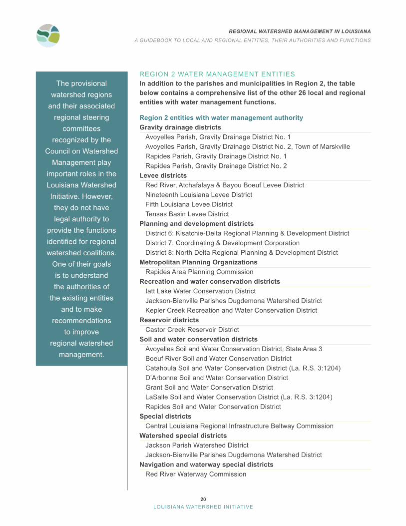
REGION 2 WATER MANAGEMENT ENTITIESIn addition to the parishes and municipalities in Region 2, the table below contains a comprehensive list of the other 26 local and regional entities with water management functions.
Region 2 entities with water management authorityGravity drainage districts
Avoyelles Parish, Gravity Drainage District No . 1Avoyelles Parish, Gravity Drainage District No . 2, Town of Marskville Rapides Parish, Gravity Drainage District No . 1Rapides Parish, Gravity Drainage District No . 2
Levee districtsRed River, Atchafalaya & Bayou Boeuf Levee DistrictNineteenth Louisiana Levee DistrictFifth Louisiana Levee DistrictTensas Basin Levee District
Planning and development districtsDistrict 6: Kisatchie-Delta Regional Planning & Development DistrictDistrict 7: Coordinating & Development CorporationDistrict 8: North Delta Regional Planning & Development District
Metropolitan Planning OrganizationsRapides Area Planning Commission
Recreation and water conservation districts Iatt Lake Water Conservation DistrictJackson-Bienville Parishes Dugdemona Watershed DistrictKepler Creek Recreation and Water Conservation District
Reservoir districtsCastor Creek Reservoir District
Soil and water conservation districtsAvoyelles Soil and Water Conservation District, State Area 3Boeuf River Soil and Water Conservation DistrictCatahoula Soil and Water Conservation District (La . R .S . 3:1204)D’Arbonne Soil and Water Conservation District Grant Soil and Water Conservation DistrictLaSalle Soil and Water Conservation District (La . R .S . 3:1204)Rapides Soil and Water Conservation District
Special districtsCentral Louisiana Regional Infrastructure Beltway Commission
Watershed special districtsJackson Parish Watershed District Jackson-Bienville Parishes Dugdemona Watershed District
Navigation and waterway special districtsRed River Waterway Commission
The provisional watershed regions
and their associated regional steering
committees recognized by the
Council on Watershed Management play
important roles in the Louisiana Watershed Initiative . However, they do not have legal authority to
provide the functions identified for regional watershed coalitions .
One of their goals is to understand the authorities of
the existing entities and to make
recommendations to improve
regional watershed management .

21
REGIONAL WATERSHED MANAGEMENT IN LOUISIANA
A GUIDEBOOK TO LOCAL AND REGIONAL ENTITIES, THEIR AUTHORITIES AND FUNCTIONS
LOUISIANA WATERSHED INITIATIVE
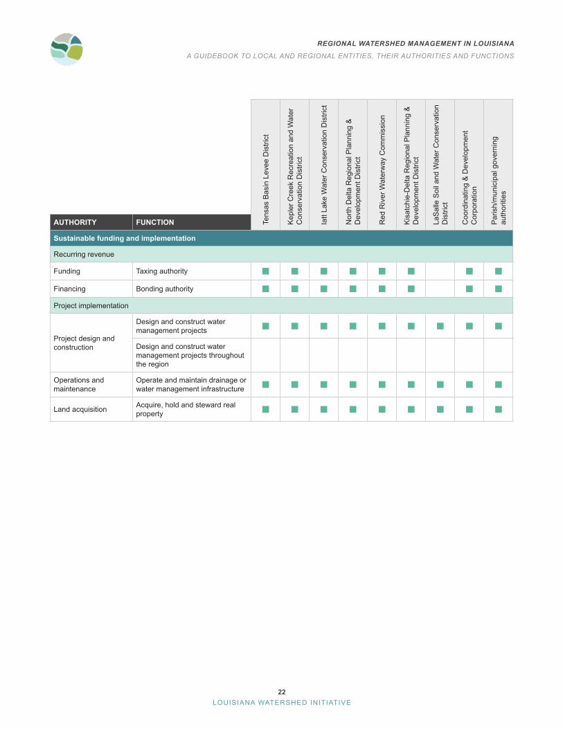
The table below compares select entities in Region 2 and their authorities and functions.
Tens
as B
asin
Lev
ee D
istri
ct
Kep
ler C
reek
Rec
reat
ion
and
Wat
er
Con
serv
atio
n D
istri
ct
Iatt
Lake
Wat
er C
onse
rvat
ion
Dis
trict
Nor
th D
elta
Reg
iona
l Pla
nnin
g &
D
evel
opm
ent D
istri
ct
Red
Riv
er W
ater
way
Com
mis
sion
Kis
atch
ie-D
elta
Reg
iona
l Pla
nnin
g &
D
evel
opm
ent D
istri
ct
LaS
alle
Soi
l and
Wat
er C
onse
rvat
ion
Dis
trict
Coo
rdin
atin
g &
Dev
elop
men
t C
orpo
ratio
n
Par
ish/
mun
icip
al g
over
ning
au
thor
ities
AUTHORITY FUNCTION
Standards development and enforcement
Building and development code
Local building code amendments
Establish standards beyond statewide code to reduce flood risk
Building code enforcement
Permit review, site inspection and/or rule-making functions for development with water management impacts
Land use regulations
Adopt new land use and zoning standards
Establish standards or processes to require water management provisions
Enforce land use and zoning standards
Permit review, site inspection and/or rule-making functions for development with water management impacts
Integrated planning
Watershed management planning
Develop and adopt watershed management plan
Develop and adopt watershed plans with authority to establish floodplain management standards
Develop and adopt watershed plans with authority to prioritize projects and project funding
Review local government plans
Review, revise and approve local plans in accordance with regional or state watershed management standards
Floodplain mapping and delineation
Authority to measure and define floodplains
Delineate floodplain boundaries
Determine floodplain expansion areas
Conduct official watershed hydrologic assessments for planning purposes
22
REGIONAL WATERSHED MANAGEMENT IN LOUISIANA
A GUIDEBOOK TO LOCAL AND REGIONAL ENTITIES, THEIR AUTHORITIES AND FUNCTIONS
LOUISIANA WATERSHED INITIATIVE
Tens
as B
asin
Lev
ee D
istri
ct
Kep
ler C
reek
Rec
reat
ion
and
Wat
er
Con
serv
atio
n D
istri
ct
Iatt
Lake
Wat
er C
onse
rvat
ion
Dis
trict
Nor
th D
elta
Reg
iona
l Pla
nnin
g &
D
evel
opm
ent D
istri
ct
Red
Riv
er W
ater
way
Com
mis
sion
Kis
atch
ie-D
elta
Reg
iona
l Pla
nnin
g &
D
evel
opm
ent D
istri
ct
LaS
alle
Soi
l and
Wat
er C
onse
rvat
ion
Dis
trict
Coo
rdin
atin
g &
Dev
elop
men
t C
orpo
ratio
n
Par
ish/
mun
icip
al g
over
ning
au
thor
ities
AUTHORITY FUNCTION
Sustainable funding and implementation
Recurring revenue
Funding Taxing authority
Financing Bonding authority
Project implementation
Project design and construction
Design and construct water management projects
Design and construct water management projects throughout the region
Operations and maintenance
Operate and maintain drainage or water management infrastructure
Land acquisition Acquire, hold and steward real property

23
REGIONAL WATERSHED MANAGEMENT IN LOUISIANA
A GUIDEBOOK TO LOCAL AND REGIONAL ENTITIES, THEIR AUTHORITIES AND FUNCTIONS
LOUISIANA WATERSHED INITIATIVE
MAPS OF SELECT ENTITIES WITH KEY WATER MANAGEMENT FUNCTIONS
Region 2Levee
Districts

24
REGIONAL WATERSHED MANAGEMENT IN LOUISIANA
A GUIDEBOOK TO LOCAL AND REGIONAL ENTITIES, THEIR AUTHORITIES AND FUNCTIONS
LOUISIANA WATERSHED INITIATIVE
Region 2Navigation
Districts

25
REGIONAL WATERSHED MANAGEMENT IN LOUISIANA
A GUIDEBOOK TO LOCAL AND REGIONAL ENTITIES, THEIR AUTHORITIES AND FUNCTIONS
LOUISIANA WATERSHED INITIATIVE
Region 2Planning and Development
Districts

26
REGIONAL WATERSHED MANAGEMENT IN LOUISIANA
A GUIDEBOOK TO LOCAL AND REGIONAL ENTITIES, THEIR AUTHORITIES AND FUNCTIONS
LOUISIANA WATERSHED INITIATIVE
Region 2Water
Districts

27
REGIONAL WATERSHED MANAGEMENT IN LOUISIANA
A GUIDEBOOK TO LOCAL AND REGIONAL ENTITIES, THEIR AUTHORITIES AND FUNCTIONS
LOUISIANA WATERSHED INITIATIVE
Region 2 Governance AnalysisParish and municipal governing authorities have the most authority related to the development and execution of watershed management plans and projects in Region 2 . However, these governing authorities are limited in authority to their jurisdictional boundaries, such as a city, gravity drainage district or parish . Parish and municipal governments can voluntarily coordinate on regional initiatives across jurisdictional boundaries through formal agreements such as cooperative endeavor agreements or memoranda of understanding, however, these efforts sometimes face difficulties ensuring broad participation or can vary in their effectiveness based on changes to local ordinances or levels of support from local administrations .
Other political subdivisions, namely special districts, also have broad authority to implement and maintain watershed management projects . Water conservation districts can also develop and adopt watershed plans, but these plans are related to specific water bodies, such as Iatt Lake. Special districts are limited to their jurisdictional boundaries and specific purposes, which can make it difficult to coordinate project planning and implementation and to leverage their dedicated funding for projects that provide benefits beyond the specific needs, purposes or geographies these districts were created to address .
Region 2 includes three planning and development districts: Coordinating & Development Corporation, North Delta Regional Planning & Development District and Kisatchie-Delta Regional Planning & Development District. Of these, the Kisatchie-Delta Regional PDD covers the largest geographic area within Region 2. All three districts deliver externally funded programs, promote coordination, offer technical assistance and planning services within their established district boundaries and have broad authority to fund and implement projects . However, they cannot develop or enforce higher standards or codes .
REGION 2 GAP ANALYSIS Existing versus potential authorities for regional watershed coalitions
Entity typeDevelop and adopt
watershed plan Regulate
development
Develop and enforce higher
standards
Fund, construct, operate and
maintain flood risk reduction projects
Authority to operate throughout entire watershed region
Parish/municipal governing authorities
Planning and development districts
Levee districts
Water districts
Navigation districts
It should be noted that there are a few key functions that are not
provided by any entity in the region:
Review, revise and approve local plans in accordance with regional or state watershed management standards on behalf of the region
Delineate floodplain boundaries
Determine floodplain expansion areas
Design and construct projects through the entire region
None of the entities researched have clear authority to provide
the above functions.

28
REGIONAL WATERSHED MANAGEMENT IN LOUISIANA
A GUIDEBOOK TO LOCAL AND REGIONAL ENTITIES, THEIR AUTHORITIES AND FUNCTIONS
LOUISIANA WATERSHED INITIATIVE
Region 3
REGION 3 COMPRISES THE TENSAS AND MISSISSIPPI RIVERS
PARISHES AND MUNICIPALITIES IN REGION 3
BastropCaldwell Parish
Catahoula ParishClaiborne ParishConcordia Parish
DelhiEast Carroll Parish
FarmervilleFranklin ParishLincoln Parish
MonroeMorehouse ParishOuachita Parish
Ruston
Tensas ParishUnion Parish
VidaliaWest Monroe
Winnsboro

29
REGIONAL WATERSHED MANAGEMENT IN LOUISIANA
A GUIDEBOOK TO LOCAL AND REGIONAL ENTITIES, THEIR AUTHORITIES AND FUNCTIONS
LOUISIANA WATERSHED INITIATIVE
REGION 3 WATER MANAGEMENT ENTITIESIn addition to the parishes and municipalities in Region 3, the table be-low contains a comprehensive list of 28 other local and regional entities with water management functions.
Region 3 entities with water management authorityLevee districts
Fifth Louisiana Levee DistrictTensas Basin Levee District
Planning and development districtsDistrict 7: Coordinating & Development CorporationDistrict 8: North Delta Regional Planning & Development District
Recreation and water conservation districtsBlack River Lake Recreation and Water Conservation DistrictJackson-Bienville Parishes Dugdemona Watershed DistrictLake Bruin Recreation and Water Conservation DistrictLake St . John Recreation and Water Conservation DistrictLake St . Joseph Recreation and Water Conservation District (La . R .S . 38:3087 .227)Morehouse Parish Lake Commission
Reservoir districtsCastor Creek Reservoir DistrictPoverty Point Reservoir District Turkey Creek Reservoir District
Soil and water conservation districtsBoeuf River Soil and Water Conservation DistrictCatahoula Soil and Water Conservation District (La . R .S . 3:1204)D’Arbonne Soil and Water Conservation District Madison Soil and Water Conservation District Morehouse Soil and Water Conservation District Northeast Soil and Water Conservation District (La . R .S . 3:1204)East Carroll Soil and Water Conservation DistrictTensas-Concordia Soil and Water Conservation District West Carroll Soil and Water Conservation DistrictLaSalle Soil and Water Conservation District
Watershed special districtsJackson-Bienville Parishes Dugdemona Watershed DistrictBayou D’Arbonne Lake Watershed DistrictClaiborne Parish Watershed DistrictFranklin Parish Watershed District
Navigation and waterway special districtsBunches Bend Protection District
The provisional watershed regions
and their associated regional steering
committees recognized by the
Council on Watershed Management play
important roles in the Louisiana Watershed Initiative . However, they do not have legal authority to
provide the functions identified for regional watershed coalitions .
One of their goals is to understand the authorities of
the existing entities and to make
recommendations to improve
regional watershed management .

30
REGIONAL WATERSHED MANAGEMENT IN LOUISIANA
A GUIDEBOOK TO LOCAL AND REGIONAL ENTITIES, THEIR AUTHORITIES AND FUNCTIONS
LOUISIANA WATERSHED INITIATIVE
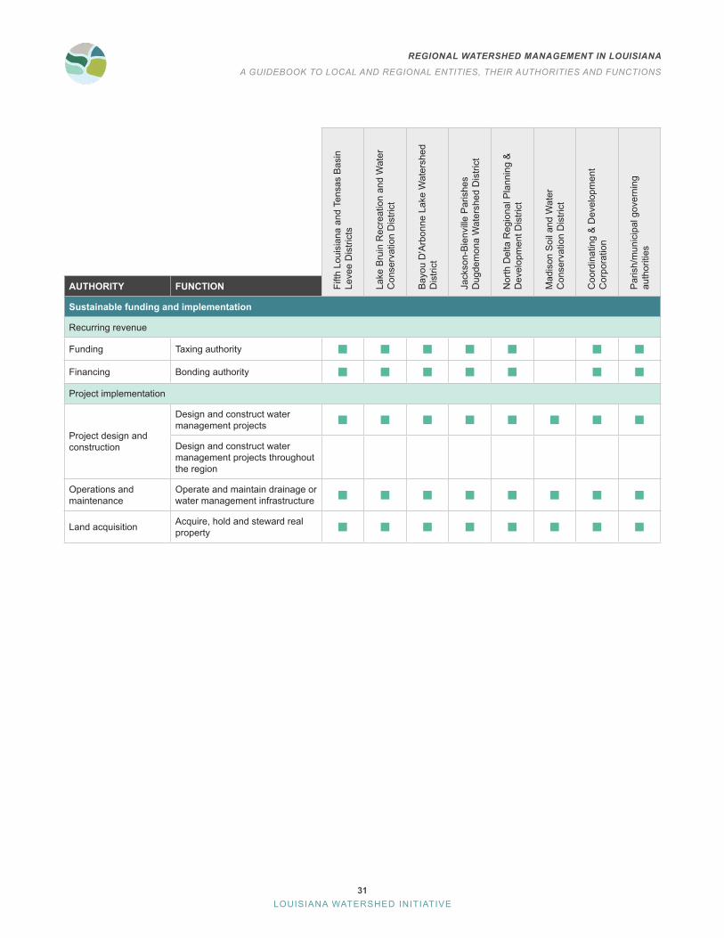
The table below compares select entities in Region 3 and their authorities and functions.
Fifth
Lou
isia
na a
nd T
ensa
s B
asin
Le
vee
Dis
trict
s
Lake
Bru
in R
ecre
atio
n an
d W
ater
C
onse
rvat
ion
Dis
trict
Bay
ou D
'Arb
onne
Lak
e W
ater
shed
D
istri
ct
Jack
son-
Bie
nvill
e P
aris
hes
Dug
dem
ona
Wat
ersh
ed D
istri
ct
Nor
th D
elta
Reg
iona
l Pla
nnin
g &
D
evel
opm
ent D
istri
ct
Mad
ison
Soi
l and
Wat
er
Con
serv
atio
n D
istri
ct
Coo
rdin
atin
g &
Dev
elop
men
t C
orpo
ratio
n
Par
ish/
mun
icip
al g
over
ning
au
thor
ities
AUTHORITY FUNCTION
Standards development and enforcement
Building and development code
Local building code amendments
Establish standards beyond statewide code to reduce flood risk
Building code enforcement
Permit review, site inspection and/or rule-making functions for development with water management impacts
Land use regulations
Adopt new land use and zoning standards
Establish standards or processes to require water management provisions
Enforce land use and zoning standards
Permit review, site inspection and/or rule-making functions for development with water management impacts
Integrated planning
Watershed management planning
Develop and adopt watershed management plans
Develop and adopt watershed plans with authority to establish floodplain management standards
Develop and adopt watershed plans with authority to prioritize projects and project funding
Local plan review
Review, revise and approve local plans in accordance with regional or state watershed management standards
Floodplain mapping and delineation
Authority to measure and define floodplain
Delineate floodplain boundaries
Determine floodplain expansion areas
Conduct official watershed hydrologic assessments for planning purposes
31
REGIONAL WATERSHED MANAGEMENT IN LOUISIANA
A GUIDEBOOK TO LOCAL AND REGIONAL ENTITIES, THEIR AUTHORITIES AND FUNCTIONS
LOUISIANA WATERSHED INITIATIVE
Fifth
Lou
isia
na a
nd T
ensa
s B
asin
Le
vee
Dis
trict
s
Lake
Bru
in R
ecre
atio
n an
d W
ater
C
onse
rvat
ion
Dis
trict
Bay
ou D
'Arb
onne
Lak
e W
ater
shed
D
istri
ct
Jack
son-
Bie
nvill
e P
aris
hes
Dug
dem
ona
Wat
ersh
ed D
istri
ct
Nor
th D
elta
Reg
iona
l Pla
nnin
g &
D
evel
opm
ent D
istri
ct
Mad
ison
Soi
l and
Wat
er
Con
serv
atio
n D
istri
ct
Coo
rdin
atin
g &
Dev
elop
men
t C
orpo
ratio
n
Par
ish/
mun
icip
al g
over
ning
au
thor
ities
AUTHORITY FUNCTION
Sustainable funding and implementation
Recurring revenue
Funding Taxing authority
Financing Bonding authority
Project implementation
Project design and construction
Design and construct water management projects
Design and construct water management projects throughout the region
Operations and maintenance
Operate and maintain drainage or water management infrastructure
Land acquisition Acquire, hold and steward real property

32
REGIONAL WATERSHED MANAGEMENT IN LOUISIANA
A GUIDEBOOK TO LOCAL AND REGIONAL ENTITIES, THEIR AUTHORITIES AND FUNCTIONS
LOUISIANA WATERSHED INITIATIVE
MAPS OF SELECT ENTITIES WITH KEY WATER MANAGEMENT FUNCTIONS
Region 3Levee
Districts

33
REGIONAL WATERSHED MANAGEMENT IN LOUISIANA
A GUIDEBOOK TO LOCAL AND REGIONAL ENTITIES, THEIR AUTHORITIES AND FUNCTIONS
LOUISIANA WATERSHED INITIATIVE
Region 3Water
Districts

34
REGIONAL WATERSHED MANAGEMENT IN LOUISIANA
A GUIDEBOOK TO LOCAL AND REGIONAL ENTITIES, THEIR AUTHORITIES AND FUNCTIONS
LOUISIANA WATERSHED INITIATIVE
Region 3Planning and Development
Districts

35
REGIONAL WATERSHED MANAGEMENT IN LOUISIANA
A GUIDEBOOK TO LOCAL AND REGIONAL ENTITIES, THEIR AUTHORITIES AND FUNCTIONS
LOUISIANA WATERSHED INITIATIVE
Region 3 Governance AnalysisWhile Region 3 has a number of entities with some authority related to water management, they are limited in both authority and jurisdiction, creating gaps in the ability to manage water—specifically flood risk—at the watershed level. Parish and municipal governing authorities have the broadest authority to create and execute watershed management plans through the enforcement of development regulations and implementation of projects . By their nature, however, these governing authorities are limited to their jurisdictional boundaries, such as a city or parish, in terms of their authority to develop and execute watershed management plans. Parish and municipal governments can voluntarily coordinate on regional initiatives across jurisdictional boundaries through formal agreements such as cooperative endeavor agreements or memoranda of understanding, however, these efforts sometimes face difficulties ensuring broad participation or can vary in their effectiveness based on changes to local ordinances or levels of support from local administrations .
Multiple special districts also have the authority to implement and maintain flood control projects in Region 3, such as levee districts and conservation districts . These districts are also limited to their jurisdictional boundaries and specific purposes, which can make it difficult to coordinate project planning and implementation and to leverage their dedicated funding for projects that provide benefits beyond the specific needs, purposes or geographies these districts were created to address . For instance, the Fifth Louisiana Levee District and Tensas Basin Levee District collectively cover most of Region 3’s geography but are limited in purpose to the protection and maintenance of their respective levee systems .
In terms of geographic coverage, the North Delta Regional Planning & Development District jurisdiction covers the largest geographic area within Region 3. The district delivers externally funded programs, promotes coordination, offers technical assistance and planning services within its established district boundaries and has broad authority to fund and implement projects . However, it cannot develop or enforce higher standards or codes .
REGION 3 GAP ANALYSIS Existing versus potential authorities for regional watershed coalitions
Entity type
Develop and adopt
watershed plan Regulate
development
Develop and enforce higher
standards
Fund, construct, operate and maintain flood risk
reduction projects
Authority to operate throughout entire watershed region
Parish/municipal governing authorities
Planning and development districts
Levee districts
Water districts
Navigation districts
It should be noted that there are a few key functions that are not
provided by any entity in the region:
Review, revise and approve local plans in accordance with regional or state watershed management standards on behalf of the region
Delineate floodplain boundaries
Determine floodplain expansion areas
Design and construct projects throughout the entire region
None of the entities researched have clear authority to provide
the above functions.

36
REGIONAL WATERSHED MANAGEMENT IN LOUISIANA
A GUIDEBOOK TO LOCAL AND REGIONAL ENTITIES, THEIR AUTHORITIES AND FUNCTIONS
LOUISIANA WATERSHED INITIATIVE
Region 4
REGION 4 COMPRISES THE SABINE RIVER, RED RIVER AND THE COAST
PARISHES AND MUNICIPALITIES IN REGION 4
Allen ParishBeauregard ParishCalcasieu ParishCameron Parish
DeQuincyDeRidder
DeSoto Parish
Grand CaneIowa
Jefferson Davis ParishKinder
Lake CharlesLeesville
Rapides Parish
ReevesRosepine
Sabine Parish Sulphur
Vernon ParishVinton
Westlake

37
REGIONAL WATERSHED MANAGEMENT IN LOUISIANA
A GUIDEBOOK TO LOCAL AND REGIONAL ENTITIES, THEIR AUTHORITIES AND FUNCTIONS
LOUISIANA WATERSHED INITIATIVE
REGION 4 WATER MANAGEMENT ENTITIESIn addition to the parishes and municipalities in Region 4, the table below contains a comprehensive list of the 23 other local and regional entities with water management functions.
Region 4 entities with water management authorityCoastal zone managements
Calcasieu Parish Coastal Zone Management ProgramCameron Parish Coastal Zone Management Program
Gravity drainage districtsAllen Parish, Gravity Drainage District No .2Allen Parish, Gravity Drainage District, Blue Bayou District No . 1Beauregard Parish, Gravity Drainage District No . 6Calcasieu Parish, Gravity Drainage District No . 1Calcasieu Parish, Gravity Drainage District No . 2Cameron Parish, Gravity Drainage District No . 3Cameron Parish, Gravity Drainage District No . 4Cameron Parish, Gravity Drainage District No . 5Cameron Parish, Gravity Drainage District No . 7Cameron Parish, Gravity Drainage District No . 8Cameron Parish, Gravity Drainage District No . 9Jefferson Davis Parish, Gravity Drainage District No . 5Jefferson Davis Parish, Gravity Drainage District No . 6Jefferson Davis Parish, Gravity Drainage District No . 7Jefferson Davis Parish, Gravity Drainage District No . 9Jefferson Davis Parish, Consolidated Gravity Drainage District No . 1Jefferson Davis Parish, Gravity Drainage District, No . 1Jefferson Davis Parish, Gravity Drainage District No. 1, Sub-Drainage District AJefferson Davis Parish, Gravity Drainage District, Welsh Gravity Drainage District No . 1
Levee districtsChenier Plain Coastal Restoration & Protection AuthorityRed River, Atchafalaya & Bayou Boeuf Levee District
The provisional watershed regions
and their associated regional steering
committees recognized by the
Council on Watershed Management play
important roles in the Louisiana Watershed Initiative . However, they do not have legal authority to
provide the functions identified for regional watershed coalitions .
One of their goals is to understand the authorities of
the existing entities and to make
recommendations to improve
regional watershed management .
*This information updated based on feedback from
regional stakeholders

38
REGIONAL WATERSHED MANAGEMENT IN LOUISIANA
A GUIDEBOOK TO LOCAL AND REGIONAL ENTITIES, THEIR AUTHORITIES AND FUNCTIONS
LOUISIANA WATERSHED INITIATIVE
Planning and development districtsDistrict 5: Imperial Calcasieu Regional Planning & Development Commis-sion District 7: Coordinating & Development Corporation
Soil and water conservation districtsAllen Soil and Water Conservation DistrictCalcasieu Soil and Water Conservation DistrictGulf Coast Soil and Water Conservation DistrictJefferson Davis Soil and Water Conservation DistrictSabine Soil and Water Conservation District (La . R .S . 3:1204)Rapides Soil and Water Conservation DistrictDeSoto Soil and Water Conservation District (La . R .S . 3:1204)
Navigation and waterway special districtsSabine River AuthorityCalcasieu-Cameron Navigation DistrictRed River Waterway Commission
39
REGIONAL WATERSHED MANAGEMENT IN LOUISIANA
A GUIDEBOOK TO LOCAL AND REGIONAL ENTITIES, THEIR AUTHORITIES AND FUNCTIONS
LOUISIANA WATERSHED INITIATIVE
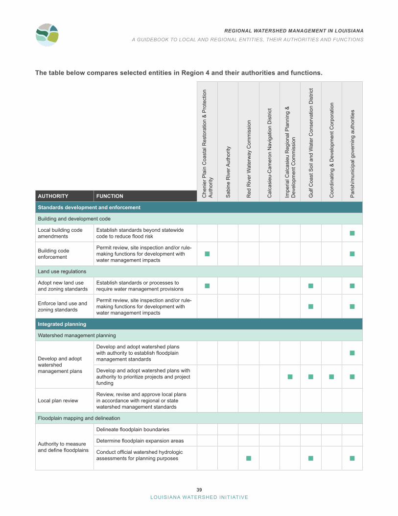
The table below compares selected entities in Region 4 and their authorities and functions.
Che
nier
Pla
in C
oast
al R
esto
ratio
n &
Pro
tect
ion
Aut
horit
y
Sab
ine
Riv
er A
utho
rity
Red
Riv
er W
ater
way
Com
mis
sion
Cal
casi
eu-C
amer
on N
avig
atio
n D
istri
ct
Impe
rial C
alca
sieu
Reg
iona
l Pla
nnin
g &
D
evel
opm
ent C
omm
issi
on
Gul
f Coa
st S
oil a
nd W
ater
Con
serv
atio
n D
istri
ct
Coo
rdin
atin
g &
Dev
elop
men
t Cor
pora
tion
Par
ish/
mun
icip
al g
over
ning
aut
horit
ies
AUTHORITY FUNCTION
Standards development and enforcement
Building and development code
Local building code amendments
Establish standards beyond statewide code to reduce flood risk
Building code enforcement
Permit review, site inspection and/or rule-making functions for development with water management impacts
Land use regulations
Adopt new land use and zoning standards
Establish standards or processes to require water management provisions
Enforce land use and zoning standards
Permit review, site inspection and/or rule-making functions for development with water management impacts
Integrated planning
Watershed management planning
Develop and adopt watershed management plans
Develop and adopt watershed plans with authority to establish floodplain management standards
Develop and adopt watershed plans with authority to prioritize projects and project funding
Local plan reviewReview, revise and approve local plans in accordance with regional or state watershed management standards
Floodplain mapping and delineation
Authority to measure and define floodplains
Delineate floodplain boundaries
Determine floodplain expansion areas
Conduct official watershed hydrologic assessments for planning purposes

40
REGIONAL WATERSHED MANAGEMENT IN LOUISIANA
A GUIDEBOOK TO LOCAL AND REGIONAL ENTITIES, THEIR AUTHORITIES AND FUNCTIONS
LOUISIANA WATERSHED INITIATIVE
Che
nier
Pla
in C
oast
al R
esto
ratio
n &
Pro
tect
ion
Aut
horit
y
Sab
ine
Riv
er A
utho
rity
Red
Riv
er W
ater
way
Com
mis
sion
Cal
casi
eu-C
amer
on N
avig
atio
n D
istri
ct
Impe
rial C
alca
sieu
Reg
iona
l Pla
nnin
g &
D
evel
opm
ent C
omm
issi
on
Gul
f Coa
st S
oil a
nd W
ater
Con
serv
atio
n D
istri
ct
Coo
rdin
atin
g &
Dev
elop
men
t Cor
pora
tion
Par
ish/
mun
icip
al g
over
ning
aut
horit
ies
AUTHORITY FUNCTION
Sustainable funding and implementation
Recurring revenue
Funding Taxing authority
Financing Bonding authority
Project implementation
Project design and construction
Design and construct water management projects
Design and construct water management projects throughout the entire region
Operation and maintenance
Operate and maintain drainage or water management infrastructure
Land acquisition Acquire, hold and steward real property

41
REGIONAL WATERSHED MANAGEMENT IN LOUISIANA
A GUIDEBOOK TO LOCAL AND REGIONAL ENTITIES, THEIR AUTHORITIES AND FUNCTIONS
LOUISIANA WATERSHED INITIATIVE
MAPS OF SELECT ENTITIES WITH KEY WATER MANAGEMENT FUNCTIONS
Region 4Levee
Districts

42
REGIONAL WATERSHED MANAGEMENT IN LOUISIANA
A GUIDEBOOK TO LOCAL AND REGIONAL ENTITIES, THEIR AUTHORITIES AND FUNCTIONS
LOUISIANA WATERSHED INITIATIVE
Region 4Navigation
DistrictsNote: Hatching means overlapping district boundaries.

43
REGIONAL WATERSHED MANAGEMENT IN LOUISIANA
A GUIDEBOOK TO LOCAL AND REGIONAL ENTITIES, THEIR AUTHORITIES AND FUNCTIONS
LOUISIANA WATERSHED INITIATIVE
Region 4Planning and Development
Districts

44
REGIONAL WATERSHED MANAGEMENT IN LOUISIANA
A GUIDEBOOK TO LOCAL AND REGIONAL ENTITIES, THEIR AUTHORITIES AND FUNCTIONS
LOUISIANA WATERSHED INITIATIVE
Region 4Water
Districts

45
REGIONAL WATERSHED MANAGEMENT IN LOUISIANA
A GUIDEBOOK TO LOCAL AND REGIONAL ENTITIES, THEIR AUTHORITIES AND FUNCTIONS
LOUISIANA WATERSHED INITIATIVE
Region 4 Governance AnalysisParish and municipal governing authorities have the most authority related to the development and execution of watershed management plans and projects in Region 4 . However, these governing authorities are limited in their use of that authority to their jurisdictional boundaries, such as a city, drainage district or parish . Parish and municipal governments can voluntarily coordinate on regional initiatives across jurisdictional boundaries through formal agreements such as cooperative endeavor agreements or memoranda of understanding, however, these efforts sometimes face difficulties ensuring broad participation or can vary in their effectiveness based on changes to local ordinances or levels of support from local administrations .
Other political subdivisions, namely special districts, also have broad authority to implement and maintain watershed management projects. Special districts are limited to their jurisdictional boundaries and specific purposes, which can make it difficult to coordinate project planning and implementation and to leverage their dedicated funding for projects that provide benefits beyond the specific needs, purposes or geographies these districts were created to address. For example, the Sabine River Authority is a special waterway district that roughly parallels the Sabine River throughout multiple parishes in Region 4, but it is limited in authority to its district boundaries and in purpose to the preservation of the Sabine River and its tributaries .
Region 4 includes three planning and development districts: the Coordinating & Development Corporation, Kisatchie-Delta Regional Planning & Development District and Imperial Calcasieu Regional Planning & Development Commission . Of these, the Imperial Calcasieu covers the largest geographic area within Region 4. All three deliver externally funded programs, promote coordination, offer technical assistance and planning services within their established district boundaries and have broad authority to implement projects . However, they cannot develop or enforce higher standards or codes .
REGION 4 GAP ANALYSIS Existing versus potential authorities for regional watershed coalitions
Entity typeDevelop and adopt
watershed plans Regulate
development
Develop and enforce higher
standards
Fund, construct, operate and
maintain flood risk reduction projects
Authority to operate throughout entire watershed region
Parish/municipal governing authorities
Planning and development districts
Levee districts
Water districts
Navigation districts
It should be noted that there are a few key functions that are not
provided by any entity in the region:
Review, revise and approve local plans in accordance with regional or state watershed management standards on behalf of the region
Delineate floodplain boundaries
Determine floodplain expansion areas
Design and construct projects throughout the entire region
None of the entities researched have clear authority to provide
the above functions.

46
REGIONAL WATERSHED MANAGEMENT IN LOUISIANA
A GUIDEBOOK TO LOCAL AND REGIONAL ENTITIES, THEIR AUTHORITIES AND FUNCTIONS
LOUISIANA WATERSHED INITIATIVE
Region 5
REGION 5 COMPRISES THE ATCHAFALAYA AND RED RIVER BASINS, BAYOUS AND THE COAST
PARISHES AND MUNICIPALITIES IN REGION 5
AbbevilleAcadia Parish
AlexandriaAllen Parish
Avoyelles ParishBerwick
Breaux BridgeBroussard
BunkieCalcasieu Parish
Cameron ParishCarencro
CottonportCrowleyEunice
Evangeline ParishFranklin
GlenmoraGueydan
Iberia Parish
Iberville ParishJefferson Davis Parish
KaplanLafayette
Lafayette ParishLivoniaMamou
New IberiaPatterson
Pointe Coupee Parish
Rapides ParishRayneScott
St . Landry ParishSt . Martin ParishSt . Mary ParishVermilion Parish
Ville PlatteWelsh
Youngsville

47
REGIONAL WATERSHED MANAGEMENT IN LOUISIANA
A GUIDEBOOK TO LOCAL AND REGIONAL ENTITIES, THEIR AUTHORITIES AND FUNCTIONS
LOUISIANA WATERSHED INITIATIVE
REGION 5 WATER MANAGEMENT ENTITIESIn addition to the parishes and municipalities in Region 5, the table below contains a comprehensive list of the 83 other local and regional entities with water management functions.
Region 5 entities with water management authorityCoastal zone management
Calcasieu Parish Coastal Zone Management ProgramCameron Parish Coastal Zone Management Program
Fresh water districtsTeche-Vermilion Fresh Water District
Gravity drainage districtsAcadia Parish, Gravity Drainage District, Bayou des Cannes-NezpiqueAcadia Parish, Gravity Drainage District, Bayou MalletAcadia Parish, Consolidated Gravity Drainage District No . 1Acadia Parish, Gravity Drainage District, Iota Long PointAcadia Parish, Gravity Drainage District, Second Ward No . 1Acadia Parish, Gravity Drainage District, Second Ward No . 2Acadia Parish, Gravity Drainage District, First WardAcadia Parish, Gravity Drainage District, Fourth WardAcadia Parish, Gravity Drainage District, Sixth Ward & CrowleyAcadia Parish, Gravity Drainage District, Bayou Plaquemine & WikoffAcadia Parish, Gravity Drainage District, Egan Drainage District No . 1 Allen Parish, Gravity Drainage District No .2Allen Parish, Gravity Drainage District, Blue Bayou District No . 1Avoyelles Parish, Gravity Drainage District No . 1Calcasieu Parish, Gravity Drainage District No . 2 of Ward 7Calcasieu Parish, Gravity Drainage District No . 4 of Ward 3Calcasieu Parish, Gravity Drainage District No. 4, Gravity Sub-Drainage District No . 2 of Ward 3Calcasieu Parish, Gravity Drainage District No. 4, Gravity Sub-Drainage Drainage District No . 1 of Ward 3Calcasieu Parish, Gravity Drainage District No . 5 of Ward 4Calcasieu Parish, Gravity Drainage District No . 6 of Wards 5 and 6Calcasieu Parish, Gravity Drainage District No . 7 of Ward 8Calcasieu Parish, Gravity Drainage District No . 8 of Ward 1Calcasieu Parish, Gravity Drainage District No . 9 of Ward 2Cameron Parish, Gravity Drainage District No . 3Cameron Parish, Gravity Drainage District No . 4Cameron Parish, Gravity Drainage District No . 5Cameron Parish, Gravity Drainage District No . 7Cameron Parish, Gravity Drainage District No . 8Cameron Parish, Gravity Drainage District No . 9Evangeline Parish, Gravity Drainage District, Dunald No . 4
The provisional watershed regions
and their associated regional steering
committees recognized by the
Council on Watershed Management play
important roles in the Louisiana Watershed Initiative . However, they do not have legal authority to
provide the functions identified for regional watershed coalitions .
One of their goals is to understand the authorities of
the existing entities and to make
recommendations to improve
regional watershed management .
*This information has been updated based on feedback from regional
stakeholders

48
REGIONAL WATERSHED MANAGEMENT IN LOUISIANA
A GUIDEBOOK TO LOCAL AND REGIONAL ENTITIES, THEIR AUTHORITIES AND FUNCTIONS
LOUISIANA WATERSHED INITIATIVE
Evangeline Parish, Gravity Drainage District, Eunice No . 9Evangeline Parish, Gravity Drainage District, Mamou No . 5Evangeline Parish, Gravity Drainage District, Prairie Mamou No . 8Evangeline Parish, Gravity Drainage District, Vidrine No . 7Jefferson Davis Parish, Gravity Drainage District No . 5Jefferson Davis Parish, Gravity Drainage District No . 6Jefferson Davis Parish, Gravity Drainage District No . 7Jefferson Davis Parish, Gravity Drainage District No . 9Jefferson Davis Parish, Consolidated Gravity Drainage District No . 1Jefferson Davis Parish, Gravity Drainage District No . 1Jefferson Davis Parish, Gravity Drainage District No . 1, Gravity Sub-Drainage District AJefferson Davis Parish, Welsh Gravity Drainage District No . 1Rapides Parish, Gravity Drainage District No . 1Rapides Parish, Rapides Parish Gravity Drainage District No . 2St . Mary Parish, Bayou Cypremort Gravity Drainage District No . 1St . Mary Parish, Consolidated Gravity Drainage District No . 1St . Mary Parish, Consolidated Gravity Drainage District No . 2St. Mary Parish, Gravity Drainage District No. 2, Gravity Sub-Drainage District No . 1 St . Mary Parish, Gravity Drainage District No . 3St . Mary Parish, Gravity Drainage District No . 5St . Mary Parish, Gravity Drainage District No . 6St . Mary Parish, Gravity Drainage District No . 2
Levee districtsAtchafalaya Basin Levee DistrictChenier Plain Coastal Restoration & Protection AuthorityIberia Parish Levee, Hurricane and Conservation DistrictRed River, Atchafalaya & Bayou Boeuf Levee DistrictSquirrel Run Levee and Drainage DistrictSt . Mary Levee District
Planning and development districtsDistrict 4: Acadiana Planning Commission
Metropolitan Planning OrganizationsRapides Area Planning Commission
Soil and water conservation districtsAcadia Soil and Water Conservation DistrictAvoyelles Soil and Water Conservation DistrictIberia Soil and Water Conservation DistrictLower Delta Soil and Water Conservation DistrictSt . Landry Soil and Water Conservation DistrictSt . Mary Soil and Water Conservation DistrictUpper Delta Soil and Water Conservation DistrictVermilion Soil and Water Conservation District

49
REGIONAL WATERSHED MANAGEMENT IN LOUISIANA
A GUIDEBOOK TO LOCAL AND REGIONAL ENTITIES, THEIR AUTHORITIES AND FUNCTIONS
LOUISIANA WATERSHED INITIATIVE
Allen Soil and Water Conservation DistrictCapital Soil and Water Conservation DistrictGulf Coast Soil and Water Conservation DistrictJefferson Davis Soil and Water Conservation DistrictRapides Soil and Water Conservation DistrictEvangeline Soil and Water Conservation DistrictLafayette and St . Martin Parish Soil and Water Conservation District
Navigation and waterway special districtsJennings Navigation DistrictSabine River AuthorityAcadiana Gulf of Mexico Access Channel Deepening ProjectCalcasieu-Cameron Navigation DistrictRed River Waterway Commission
50
REGIONAL WATERSHED MANAGEMENT IN LOUISIANA
A GUIDEBOOK TO LOCAL AND REGIONAL ENTITIES, THEIR AUTHORITIES AND FUNCTIONS
LOUISIANA WATERSHED INITIATIVE
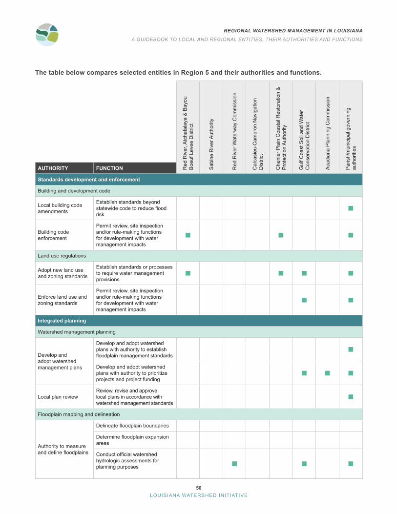
The table below compares selected entities in Region 5 and their authorities and functions.
Red
Riv
er, A
tcha
fala
ya &
Bay
ou
Boe
uf L
evee
Dis
trict
Sab
ine
Riv
er A
utho
rity
Red
Riv
er W
ater
way
Com
mis
sion
Cal
casi
eu-C
amer
on N
avig
atio
n D
istri
ct
Che
nier
Pla
in C
oast
al R
esto
ratio
n &
P
rote
ctio
n A
utho
rity
Gul
f Coa
st S
oil a
nd W
ater
C
onse
rvat
ion
Dis
trict
Aca
dian
a P
lann
ing
Com
mis
sion
Par
ish/
mun
icip
al g
over
ning
au
thor
ities
AUTHORITY FUNCTION
Standards development and enforcement
Building and development code
Local building code amendments
Establish standards beyond statewide code to reduce flood risk
Building code enforcement
Permit review, site inspection and/or rule-making functions for development with water management impacts
Land use regulations
Adopt new land use and zoning standards
Establish standards or processes to require water management provisions
Enforce land use and zoning standards
Permit review, site inspection and/or rule-making functions for development with water management impacts
Integrated planning
Watershed management planning
Develop and adopt watershed management plans
Develop and adopt watershed plans with authority to establish floodplain management standards
Develop and adopt watershed plans with authority to prioritize projects and project funding
Local plan reviewReview, revise and approve local plans in accordance with watershed management standards
Floodplain mapping and delineation
Authority to measure and define floodplains
Delineate floodplain boundaries
Determine floodplain expansion areas
Conduct official watershed hydrologic assessments for planning purposes

51
REGIONAL WATERSHED MANAGEMENT IN LOUISIANA
A GUIDEBOOK TO LOCAL AND REGIONAL ENTITIES, THEIR AUTHORITIES AND FUNCTIONS
LOUISIANA WATERSHED INITIATIVE
Red
Riv
er, A
tcha
fala
ya &
Bay
ou
Boe
uf L
evee
Dis
trict
Sab
ine
Riv
er A
utho
rity
Red
Riv
er W
ater
way
Com
mis
sion
Cal
casi
eu-C
amer
on N
avig
atio
n D
istri
ct
Che
nier
Pla
in C
oast
al R
esto
ratio
n &
P
rote
ctio
n A
utho
rity
Gul
f Coa
st S
oil a
nd W
ater
C
onse
rvat
ion
Dis
trict
Aca
dian
a P
lann
ing
Com
mis
sion
Par
ish/
mun
icip
al g
over
ning
au
thor
ities
AUTHORITY FUNCTION
Sustainable funding and implementation
Recurring revenue
Funding Taxing authority
Financing Bonding authority
Project implementation
Project design and construction
Design and construct water management projects
Design and construct water management projects throughout the entire region
Operation and maintenance
Operate and maintain drainage or water management infrastructure
Land acquisition Acquire, hold and steward real property

52
REGIONAL WATERSHED MANAGEMENT IN LOUISIANA
A GUIDEBOOK TO LOCAL AND REGIONAL ENTITIES, THEIR AUTHORITIES AND FUNCTIONS
LOUISIANA WATERSHED INITIATIVE
MAPS OF SELECT ENTITIES WITH KEY WATER MANAGEMENT FUNCTIONS
Region 5Water
Districts

53
REGIONAL WATERSHED MANAGEMENT IN LOUISIANA
A GUIDEBOOK TO LOCAL AND REGIONAL ENTITIES, THEIR AUTHORITIES AND FUNCTIONS
LOUISIANA WATERSHED INITIATIVE
Region 5Levee
Districts

54
REGIONAL WATERSHED MANAGEMENT IN LOUISIANA
A GUIDEBOOK TO LOCAL AND REGIONAL ENTITIES, THEIR AUTHORITIES AND FUNCTIONS
LOUISIANA WATERSHED INITIATIVE
Region 5Navigation
Districts

55
REGIONAL WATERSHED MANAGEMENT IN LOUISIANA
A GUIDEBOOK TO LOCAL AND REGIONAL ENTITIES, THEIR AUTHORITIES AND FUNCTIONS
LOUISIANA WATERSHED INITIATIVE
Region 5Planning and Development
Districts

56
REGIONAL WATERSHED MANAGEMENT IN LOUISIANA
A GUIDEBOOK TO LOCAL AND REGIONAL ENTITIES, THEIR AUTHORITIES AND FUNCTIONS
LOUISIANA WATERSHED INITIATIVE
Region 5 Governance AnalysisRegion 5 is home to multiple entities with some authority related to water management, but these entities are limited in both authority and jurisdiction, creating gaps in the ability to manage flood risk across political boundaries. Parish and municipal governing authorities have the broadest authority to create and execute watershed management plans by enforcing development regulations and implementing projects . By their nature, however, these governing authorities are limited in their authority to develop and execute watershed management plans by their jurisdictional boundaries, such as a city, parish or drainage district . Parish and municipal governments can voluntarily coordinate on regional initiatives across jurisdictional boundaries through formal agreements such as cooperative endeavor agreements or memoranda of understanding, however, these efforts sometimes face difficulties ensuring broad participation or can vary in their effectiveness based on changes to local ordinances or levels of support from local administrations .
Multiple entities have the authority to implement and maintain flood risk reduction projects in Region 5, such as levee districts and conservation districts . These districts are also limited to their jurisdictional boundaries and specific purposes, which can make it difficult to coordinate project planning and implementation and to leverage their dedicated funding for projects that provide benefits beyond the specific needs, purposes or geographies these districts were created to address . For instance, the three levee districts in Region 5 are limited in purpose to the protection and maintenance of their respective levee systems and in geographically smaller districts that include their respective levee systems .
While Region 5 includes five planning and development districts, the Acadiana Planning Commission covers the largest geographic area in the region . The APC delivers externally funded programs, promotes coordination, offers technical assistance and planning services within its established district boundaries and has broad authority to implement projects . However, it cannot develop or enforce higher standards or codes . The Rapides Area Planning Commission also serves as an important resource in floodplain management, planning and permit review.
REGION 5 GAP ANALYSIS Existing versus potential authorities for regional watershed coalitions
Entity typeDevelop and adopt
watershed plans Regulate
development
Develop and enforce higher
standards
Fund, construct, operate and maintain flood risk
reduction projects
Authority to operate throughout entire watershed region
Parish/municipal governing authorities
Planning and development districts
Levee districts
Water districts
Navigation districts
It should be noted that there are a few key functions that
are not provided by any entity in the region:
Review, revise and approve local plans in accordance with
regional or state watershed management standards on
behalf of the region
Delineate floodplain boundaries
Determine floodplain expansion areas
Design and construct projects throughout the entire region
None of the entities researched have clear
authority to provide the above functions.

57
REGIONAL WATERSHED MANAGEMENT IN LOUISIANA
A GUIDEBOOK TO LOCAL AND REGIONAL ENTITIES, THEIR AUTHORITIES AND FUNCTIONS
LOUISIANA WATERSHED INITIATIVE
Region 6
REGION 6 IS LOCATED BETWEEN THE LOWER ATCHAFALAYA AND MISSISSIPPI RIVERS, CONNECTING BAYOUS AND THE COAST
PARISHES AND MUNICIPALITIES IN REGION 6
AddisAscension Parish
Assumption ParishBrusly
DonaldsonvilleFordoche
Golden MeadowGrand Isle
GretnaGrosse TeteIberia Parish
Iberville Parish
Jean LafitteJefferson ParishLafourche Parish
LockportMorgan City
Orleans ParishNew OrleansNew RoadsPlaquemine
Plaquemines ParishPointe Coupee Parish
Port Allen
SorrentoSt . Charles ParishSt . James Parish
St . John the Baptist ParishSt . Martin ParishSt . Mary Parish
Terrebonne ParishThibodaux
West Baton Rouge ParishWestwego
White Castle
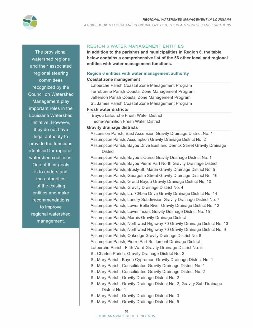
58
REGIONAL WATERSHED MANAGEMENT IN LOUISIANA
A GUIDEBOOK TO LOCAL AND REGIONAL ENTITIES, THEIR AUTHORITIES AND FUNCTIONS
LOUISIANA WATERSHED INITIATIVE
REGION 6 WATER MANAGEMENT ENTITIESIn addition to the parishes and municipalities in Region 6, the table below contains a comprehensive list of the 56 other local and regional entities with water management functions.
Region 6 entities with water management authorityCoastal zone management
Lafourche Parish Coastal Zone Management ProgramTerrebonne Parish Coastal Zone Management ProgramJefferson Parish Coastal Zone Management ProgramSt . James Parish Coastal Zone Management Program
Fresh water districts Bayou Lafourche Fresh Water District Teche-Vermilion Fresh Water District
Gravity drainage districtsAscension Parish, East Ascension Gravity Drainage District No . 1Assumption Parish, Assumption Gravity Drainage District No . 2Assumption Parish, Bayou Drive East and Derrick Street Gravity Drainage DistrictAssumption Parish, Bayou L’Ourse Gravity Drainage District No . 1Assumption Parish, Bayou Pierre Part North Gravity Drainage District Assumption Parish, Brusly-St. Martin Gravity Drainage District No. 5Assumption Parish, Georgette Street Gravity Drainage District No . 16Assumption Parish, Grand Bayou Gravity Drainage District No . 10Assumption Parish, Gravity Drainage District No . 4Assumption Parish, La. 70/Lee Drive Gravity Drainage District No. 14Assumption Parish, Landry Subdivision Gravity Drainage District No . 7Assumption Parish, Lower Belle River Gravity Drainage District No . 12Assumption Parish, Lower Texas Gravity Drainage District No. 15Assumption Parish, Marais Gravity Drainage DistrictAssumption Parish, Northwest Highway 70 Gravity Drainage District No . 13Assumption Parish, Northwest Highway 70 Gravity Drainage District No . 9Assumption Parish, Oakridge Gravity Drainage District No . 8Assumption Parish, Pierre Part Settlement Drainage District Lafourche Parish, Fifth Ward Gravity Drainage District No . 5St . Charles Parish, Gravity Drainage District No . 2St . Mary Parish, Bayou Cypremort Gravity Drainage District No . 1St . Mary Parish, Consolidated Gravity Drainage District No . 1St . Mary Parish, Consolidated Gravity Drainage District No . 2St . Mary Parish, Gravity Drainage District No . 2St. Mary Parish, Gravity Drainage District No. 2, Gravity Sub-Drainage District No . 1 St . Mary Parish, Gravity Drainage District No . 3St . Mary Parish, Gravity Drainage District No . 5
The provisional watershed regions
and their associated regional steering
committees recognized by the
Council on Watershed Management play
important roles in the Louisiana Watershed Initiative . However, they do not have legal authority to
provide the functions identified for regional watershed coalitions .
One of their goals is to understand the authorities of the existing
entities and make recommendations
to improve regional watershed
management .

59
REGIONAL WATERSHED MANAGEMENT IN LOUISIANA
A GUIDEBOOK TO LOCAL AND REGIONAL ENTITIES, THEIR AUTHORITIES AND FUNCTIONS
LOUISIANA WATERSHED INITIATIVE
St . Mary Parish, Gravity Drainage District No . 6Levee districts
Atchafalaya Basin Levee DistrictGrand Isle Independent Levee DistrictIberia Parish Levee, Hurricane and Conservation DistrictLafitte Area Independent Levee DistrictLafourche Basin Levee DistrictNorth Lafourche Conservation, Levee and Drainage DistrictPontchartrain Levee DistrictSouth Lafourche Levee DistrictSoutheast Louisiana Flood Protection Authority-WestSt . Mary Levee DistrictTerrebonne Levee & Conservation District
Planning and development districtsDistrict 1: New Orleans Regional Planning CommissionDistrict 3: South Central Planning & Development Commission
Recreation and water conservation districtsCapital Area Ground Water Conservation Commission
Soil and water conservation districtsLafourche-Terrebonne Soil and Water Conservation DistrictLower Delta Soil and Water Conservation DistrictNew River Soil and Water Conservation DistrictPlaquemines Soil and Water Conservation DistrictUpper Delta Soil and Water Conservation DistrictCapital Soil and Water Conservation District
Watershed special districtsFalse River Watershed Council
Navigation and waterway special districtsMississippi River Deepening Project

60
REGIONAL WATERSHED MANAGEMENT IN LOUISIANA
A GUIDEBOOK TO LOCAL AND REGIONAL ENTITIES, THEIR AUTHORITIES AND FUNCTIONS
LOUISIANA WATERSHED INITIATIVE
The table below compares selected entities in Region 6 and their authorities and functions.
Atc
hafa
laya
Bas
in L
evee
Dis
trict
Sou
thea
st L
ouis
iana
Flo
od
Pro
tect
ion
Aut
horit
y-W
est
Cap
ital A
rea
Gro
und
Wat
er
Con
serv
atio
n C
omm
issi
on
Sou
th C
entra
l Pla
nnin
g &
D
evel
opm
ent C
omm
issi
on
New
Orle
ans
Reg
iona
l Pla
nnin
g C
omm
issi
on
Pla
quem
ines
Soi
l and
Wat
er
Con
serv
atio
n D
istri
ct
Low
er D
elta
Soi
l and
Wat
er
Con
serv
atio
n D
istri
ct
Par
ish/
mun
icip
al g
over
ning
au
thor
ities
AUTHORITY FUNCTION
Standards development and enforcement
Building and development code
Local building code amendments
Establish standards beyond statewide code to reduce flood risk
Building code enforcement
Permit review, site inspection and/or rule-making functions for development with water management impacts
Land use regulations
Adopt new land use and zoning standards
Establish standards or processes to require water management provisions
Enforce land use and zoning standards
Permit review, site inspection and/or rule-making functions for development with water management impacts
Integrated planning
Watershed management planning
Develop and adopt watershed management plans
Develop and adopt watershed plans with authority to establish floodplain management standards
Develop and adopt watershed plans with authority to prioritize projects and project funding
Local plan review
Review, revise and approve local plans in accordance with regional or state watershed management standards
Floodplain mapping and delineation
Authority to measure and define floodplains
Delineate floodplain boundaries
Determine floodplain expansion areas
Conduct official watershed hydrologic assessments for planning purposes

61
REGIONAL WATERSHED MANAGEMENT IN LOUISIANA
A GUIDEBOOK TO LOCAL AND REGIONAL ENTITIES, THEIR AUTHORITIES AND FUNCTIONS
LOUISIANA WATERSHED INITIATIVE
Atc
hafa
laya
Bas
in L
evee
Dis
trict
Sou
thea
st L
ouis
iana
Flo
od
Pro
tect
ion
Aut
horit
y-W
est
Cap
ital A
rea
Gro
und
Wat
er
Con
serv
atio
n C
omm
issi
on
Sou
th C
entra
l Pla
nnin
g &
D
evel
opm
ent C
omm
issi
on
New
Orle
ans
Reg
iona
l Pla
nnin
g C
omm
issi
on
Pla
quem
ines
Soi
l and
Wat
er
Con
serv
atio
n D
istri
ct
Low
er D
elta
Soi
l and
Wat
er
Con
serv
atio
n D
istri
ct
Par
ish/
mun
icip
al g
over
ning
au
thor
ities
AUTHORITY FUNCTION
Sustainable funding and emplementation
Recurring revenue
Funding Taxing authority
Financing Bonding authority
Project implementation
Project design and construction
Design and construct water management projects
Design and construct water management projects throughout the entire region
Operation and maintenance
Operate and maintain drainage or water management infrastructure
Land acquisition Acquire, hold and steward real property

62
REGIONAL WATERSHED MANAGEMENT IN LOUISIANA
A GUIDEBOOK TO LOCAL AND REGIONAL ENTITIES, THEIR AUTHORITIES AND FUNCTIONS
LOUISIANA WATERSHED INITIATIVE
MAPS OF SELECT ENTITIES WITH KEY WATER MANAGEMENT FUNCTIONS
Region 6Levee
Districts
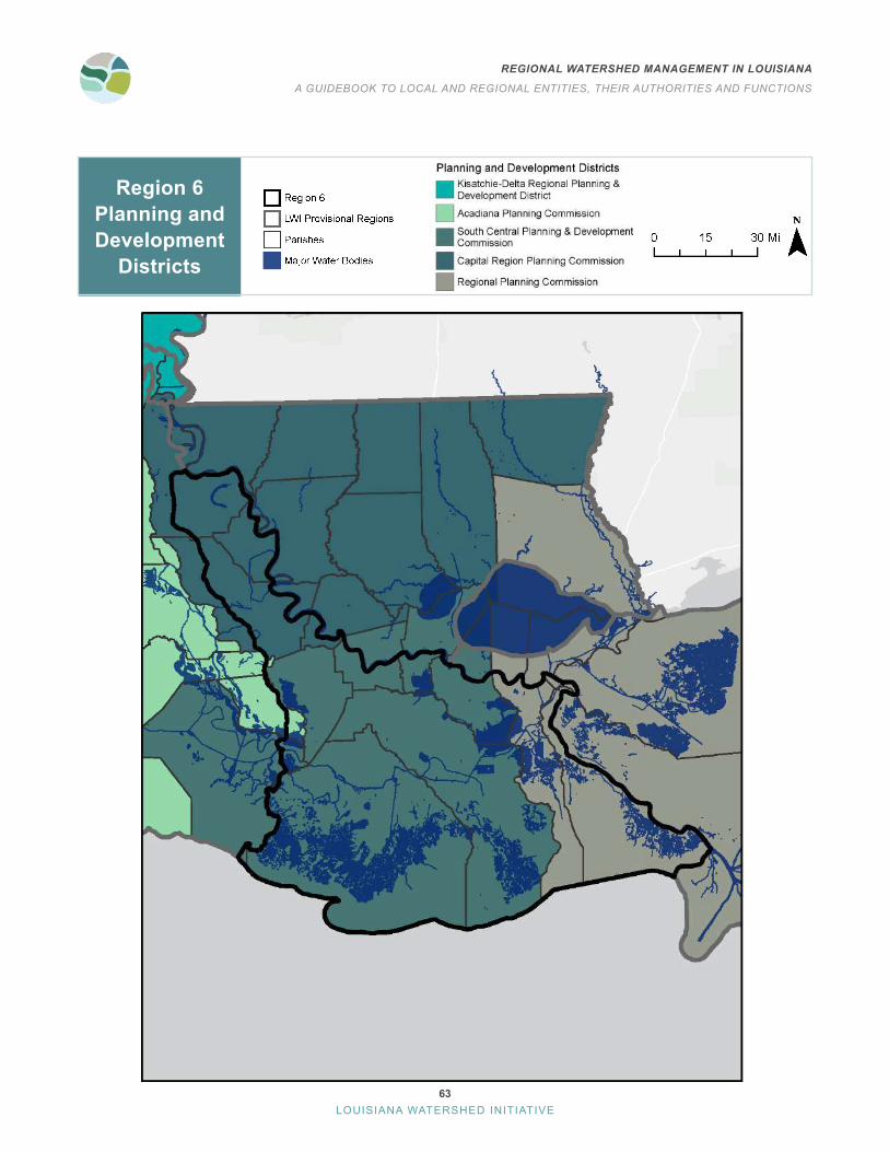
63
REGIONAL WATERSHED MANAGEMENT IN LOUISIANA
A GUIDEBOOK TO LOCAL AND REGIONAL ENTITIES, THEIR AUTHORITIES AND FUNCTIONS
LOUISIANA WATERSHED INITIATIVE
Region 6Planning and Development
Districts

64
REGIONAL WATERSHED MANAGEMENT IN LOUISIANA
A GUIDEBOOK TO LOCAL AND REGIONAL ENTITIES, THEIR AUTHORITIES AND FUNCTIONS
LOUISIANA WATERSHED INITIATIVE
Region 6Water
Districts
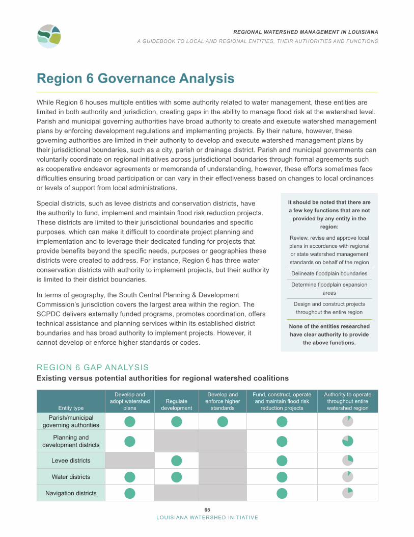
65
REGIONAL WATERSHED MANAGEMENT IN LOUISIANA
A GUIDEBOOK TO LOCAL AND REGIONAL ENTITIES, THEIR AUTHORITIES AND FUNCTIONS
LOUISIANA WATERSHED INITIATIVE
Region 6 Governance AnalysisWhile Region 6 houses multiple entities with some authority related to water management, these entities are limited in both authority and jurisdiction, creating gaps in the ability to manage flood risk at the watershed level. Parish and municipal governing authorities have broad authority to create and execute watershed management plans by enforcing development regulations and implementing projects . By their nature, however, these governing authorities are limited in their authority to develop and execute watershed management plans by their jurisdictional boundaries, such as a city, parish or drainage district . Parish and municipal governments can voluntarily coordinate on regional initiatives across jurisdictional boundaries through formal agreements such as cooperative endeavor agreements or memoranda of understanding, however, these efforts sometimes face difficulties ensuring broad participation or can vary in their effectiveness based on changes to local ordinances or levels of support from local administrations .
Special districts, such as levee districts and conservation districts, have the authority to fund, implement and maintain flood risk reduction projects. These districts are limited to their jurisdictional boundaries and specific purposes, which can make it difficult to coordinate project planning and implementation and to leverage their dedicated funding for projects that provide benefits beyond the specific needs, purposes or geographies these districts were created to address . For instance, Region 6 has three water conservation districts with authority to implement projects, but their authority is limited to their district boundaries .
In terms of geography, the South Central Planning & Development Commission’s jurisdiction covers the largest area within the region . The SCPDC delivers externally funded programs, promotes coordination, offers technical assistance and planning services within its established district boundaries and has broad authority to implement projects . However, it cannot develop or enforce higher standards or codes .
REGION 6 GAP ANALYSIS Existing versus potential authorities for regional watershed coalitions
Entity type
Develop and adopt watershed
plans Regulate
development
Develop and enforce higher
standards
Fund, construct, operate and maintain flood risk
reduction projects
Authority to operate throughout entire watershed region
Parish/municipal governing authorities
Planning and development districts
Levee districts
Water districts
Navigation districts
It should be noted that there are a few key functions that are not
provided by any entity in the region:
Review, revise and approve local plans in accordance with regional or state watershed management standards on behalf of the region
Delineate floodplain boundaries
Determine floodplain expansion areas
Design and construct projects throughout the entire region
None of the entities researched have clear authority to provide
the above functions.
66
REGIONAL WATERSHED MANAGEMENT IN LOUISIANA
A GUIDEBOOK TO LOCAL AND REGIONAL ENTITIES, THEIR AUTHORITIES AND FUNCTIONS
LOUISIANA WATERSHED INITIATIVE
Region 7
REGION 7 IS LOCATED ALONG THE MISSISSIPPI RIVER AND LAKE PONTCHARTRAIN BASIN
PARISHES AND MUNICIPALITIES IN REGION 7
Abita SpringsAlbany
Amite CityAscension Parish
BakerBaton Rouge
BogalusaCentral
CovingtonDenham Springs
East Baton Rouge ParishEast Feliciana Parish
FolsomFranklinton
GonzalesGramercyHammond
Iberville ParishKentwood
Livingston ParishLutcher
MadisonvilleMandevillePearl RiverPlaqueminePonchatoula
SlaughterSlidell
SorrentoSt . Charles Parish
St . FrancisvilleSt . Gabriel
St . Helena ParishSt . James Parish
St . John the Baptist ParishSt . Tammany ParishTangipahoa Parish
WalkerWashington Parish
West Feliciana ParishZachary

67
REGIONAL WATERSHED MANAGEMENT IN LOUISIANA
A GUIDEBOOK TO LOCAL AND REGIONAL ENTITIES, THEIR AUTHORITIES AND FUNCTIONS
LOUISIANA WATERSHED INITIATIVE
REGION 7 WATER MANAGEMENT ENTITIESIn addition to the parishes and municipalities in Region 7, the table below contains a comprehensive list of the 40 other local and regional entities with water management functions.
Region 7 entities with water management authorityCoastal zone management
St . Tammany Parish Coastal Zone Management ProgramSt . James Parish Coastal Zone Management Program
Gravity Drainage DistrictsAscension Parish, East Ascension Gravity Drainage District No . 1Livingston Parish, Gravity Drainage District No . 1Livingston Parish, Gravity Drainage District No . 2Livingston Parish, Gravity Drainage District No . 5Livingston Parish, Gravity Drainage District No . 6Livingston Parish, Gravity Drainage District No . 7St . Charles Parish, Gravity Drainage District No . 2St . Tammany Parish, Gravity Drainage District No . 3St . Tammany Parish, Gravity Drainage District No . 4St . Tammany Parish, Gravity Drainage District No . 5St. Tammany Parish, Gravity Drainage District No. 5, Sub-Drainage District No. 1St. Tammany Parish, Gravity Drainage District No. 5, Sub-Drainage District No. 2St. Tammany Parish, Gravity Drainage District No. 5, Sub-Drainage District No. 3St. Tammany Parish, Gravity Drainage District No. 5, Sub-Drainage District No. 4St. Tammany Parish, Gravity Drainage District No. 5, Sub-Drainage District No. 5St . Tammany Parish, Gravity Drainage District No . 6Tangipahoa Parish, Gravity Drainage District No . 4Tangipahoa Parish, Gravity Drainage District No . 5Tangipahoa Parish, Consolidated Gravity Drainage District No . 1
Levee districtsAtchafalaya Basin Levee DistrictLafourche Basin Levee DistrictPontchartrain Levee DistrictSoutheast Louisiana Flood Protection Authority-East Tangipahoa Levee DistrictSt . Tammany Levee, Drainage and Conservation District
Planning and development districtsDistrict 1: New Orleans Regional Planning CommissionDistrict 2: Capital Region Planning CommissionDistrict 3: South Central Planning & Development Commission
Recreation and water conservation districtsAmite River Basin Commission, Amite River Basin Drainage and Water Conservation DistrictCapital Area Ground Water Conservation Commission
The provisional watershed regions
and their associated regional steering
committees recognized by the
Council on Watershed Management play
important roles in the Louisiana Watershed Initiative . However, they do not have legal authority to
provide the functions identified for regional watershed coalitions .
One of their goals is to understand the authorities of the existing
entities and make recommendations
to improve regional watershed
management .
68
REGIONAL WATERSHED MANAGEMENT IN LOUISIANA
A GUIDEBOOK TO LOCAL AND REGIONAL ENTITIES, THEIR AUTHORITIES AND FUNCTIONS
LOUISIANA WATERSHED INITIATIVE
Greater Baton Rouge Water Conservation DistrictSoil and water conservation districts
Crescent Soil and Water Conservation DistrictLower Delta Soil and Water Conservation DistrictNew River Soil and Water Conservation DistrictBogue Chitto-Pearl River Soil and Water Conservation DistrictCapital Soil and Water Conservation DistrictFeliciana Soil and Water Conservation DistrictTangipahoa-St. Helena Soil and Water Conservation District
Navigation and waterway special districtMississippi River Deepening Project

69
REGIONAL WATERSHED MANAGEMENT IN LOUISIANA
A GUIDEBOOK TO LOCAL AND REGIONAL ENTITIES, THEIR AUTHORITIES AND FUNCTIONS
LOUISIANA WATERSHED INITIATIVE
The table below compares selected entities in Region 7 and their authorities and functions.
St .
Tam
man
y Le
vee,
Dra
inag
e an
d C
onse
rvat
ion
Dis
trict
Am
ite R
iver
Bas
in C
omm
issi
on
New
Orle
ans
Reg
iona
l Pla
nnin
g C
omm
issi
on
Cap
ital A
rea
Gro
und
Wat
er
Con
serv
atio
n C
omm
issi
on
Gre
ater
Bat
on R
ouge
Wat
er
Con
serv
atio
n D
istri
ct
Cap
ital R
egio
n P
lann
ing
Com
mis
sion
Felic
iana
Soi
l and
Wat
er
Con
serv
atio
n D
istri
ct
Par
ish/
mun
icip
al g
over
ning
au
thor
ities
AUTHORITY FUNCTION
Standards development and enforcement
Building and development code
Local building code amendments
Establish standards beyond statewide code to reduce flood risk
Building code enforcement
Permit review, site inspection and/or rule-making functions for development with water management impacts
Land use regulations
Adopt new land use and zoning standards
Establish standards or processes to require water management provisions
Enforce land use and zoning standards
Permit review, site inspection and/or rule-making functions for development with water management impacts
Integrated planning
Watershed management planning
Develop and adopt watershed management plans
Develop and adopt watershed plans with authority to establish floodplain management standards
Develop and adopt watershed plans with authority to prioritize projects and project funding
Local plan review
Review, revise and approve local plans in accordance with regional or state watershed management standards
Floodplain mapping and delineation
Authority to measure and define floodplains
Delineate floodplain boundaries
Determine floodplain expansion areas
Conduct official watershed hydrologic assessments for planning purposes

70
REGIONAL WATERSHED MANAGEMENT IN LOUISIANA
A GUIDEBOOK TO LOCAL AND REGIONAL ENTITIES, THEIR AUTHORITIES AND FUNCTIONS
LOUISIANA WATERSHED INITIATIVE
St .
Tam
man
y Le
vee,
Dra
inag
e an
d C
onse
rvat
ion
Dis
trict
Am
ite R
iver
Bas
in C
omm
issi
on
New
Orle
ans
Reg
iona
l Pla
nnin
g C
omm
issi
on
Cap
ital A
rea
Gro
und
Wat
er
Con
serv
atio
n C
omm
issi
on
Gre
ater
Bat
on R
ouge
Wat
er
Con
serv
atio
n D
istri
ct
Cap
ital R
egio
n P
lann
ing
Com
mis
sion
Felic
iana
Soi
l and
Wat
er
Con
serv
atio
n D
istri
ct
Par
ish/
mun
icip
al g
over
ning
au
thor
ities
AUTHORITY FUNCTION
Sustainable funding and implementation
Recurring revenue
Funding Taxing authority
Financing Bonding authority
Project implementation
Project design and construction
Design and construct water management projects
Design and construct water management projects throughout the entire region
Operation and maintenance
Operate and maintain drainage or water management infrastructure
Land acquisition Acquire, hold and steward real property

71
REGIONAL WATERSHED MANAGEMENT IN LOUISIANA
A GUIDEBOOK TO LOCAL AND REGIONAL ENTITIES, THEIR AUTHORITIES AND FUNCTIONS
LOUISIANA WATERSHED INITIATIVE
MAPS OF SELECT ENTITIES WITH KEY WATER MANAGEMENT FUNCTIONS
Region 7Levee
Districts

72
REGIONAL WATERSHED MANAGEMENT IN LOUISIANA
A GUIDEBOOK TO LOCAL AND REGIONAL ENTITIES, THEIR AUTHORITIES AND FUNCTIONS
LOUISIANA WATERSHED INITIATIVE
Region 7Planning and Development
Districts

73
REGIONAL WATERSHED MANAGEMENT IN LOUISIANA
A GUIDEBOOK TO LOCAL AND REGIONAL ENTITIES, THEIR AUTHORITIES AND FUNCTIONS
LOUISIANA WATERSHED INITIATIVE
Region 7Recreation and Water
Conservation Districts Note: Hatching means overlapping district boundaries.

74
REGIONAL WATERSHED MANAGEMENT IN LOUISIANA
A GUIDEBOOK TO LOCAL AND REGIONAL ENTITIES, THEIR AUTHORITIES AND FUNCTIONS
LOUISIANA WATERSHED INITIATIVE
Region 7 Governance AnalysisRegion 7 is home to multiple entities with some authority related to water management, but these entities are limited in both authority and jurisdiction, creating gaps in the ability to manage flood risk across political boundaries . Parish and municipal governing authorities and the Amite River Basin Commission have the broadest authority to create and execute watershed management plans by enforcing development regulations and implementing projects . By their nature, however, these entities are limited to their jurisdictional boundaries, such as a city, parish or drainage district, in terms of their authority to develop and execute watershed management plans . While the Amite River Basin Commission’s boundaries cross multiple parishes, it does not span the entire LWI watershed region . Parish and municipal governments can voluntarily coordinate on regional initiatives across jurisdictional boundaries through formal agreements such as cooperative endeavor agreements or memoranda of understanding. However, these efforts sometimes face difficulties ensuring broad participation or can vary in their effectiveness based on changes to local ordinances or levels of support from local administrations .
Several special districts in Region 7 also have the authority to implement and maintain flood risk reduction projects. These districts are also limited in authority to their jurisdictional boundaries and specific purposes, which can make it difficult to coordinate project planning and implementation and to leverage their dedicated funding for projects that provide benefits beyond the specific needs, purposes or geographies these districts were created to address . For instance, the Capital Area Ground Water Conservation Commission has broad authority to develop and adopt watershed plans and to implement projects, but it is limited by its district boundaries and lack of authority to enforce regulations to support its plans .
Of the three planning and development districts in Region 7, the Capital Region Planning Commission covers the largest geographic area . The CRPC delivers externally funded programs, promotes coordination, offers technical assistance and planning services within its established district boundaries and has broad authority to develop plans and implement/coordinate projects. However, it cannot develop or enforce higher standards or codes .
REGION 7 GAP ANALYSIS Existing versus potential authorities for regional watershed coalitions
Entity type
Develop and adopt
watershed plans Regulate
development
Develop and enforce higher
standards
Fund, construct, operate and maintain flood risk
reduction projects
Authority to operate throughout entire watershed region
Parish/municipal governing authorities
Planning and development districts
Levee districts
Water districts
Navigation districts
It should be noted that there are a few key functions that are not
provided by any entity in the region:
Review, revise and approve local plans in accordance with regional or state watershed management standards on behalf of the region
Delineate floodplain boundaries
Determine floodplain expansion areas
Design and construct projects throughout the entire region
None of the entities researched have clear authority to provide
the above functions.
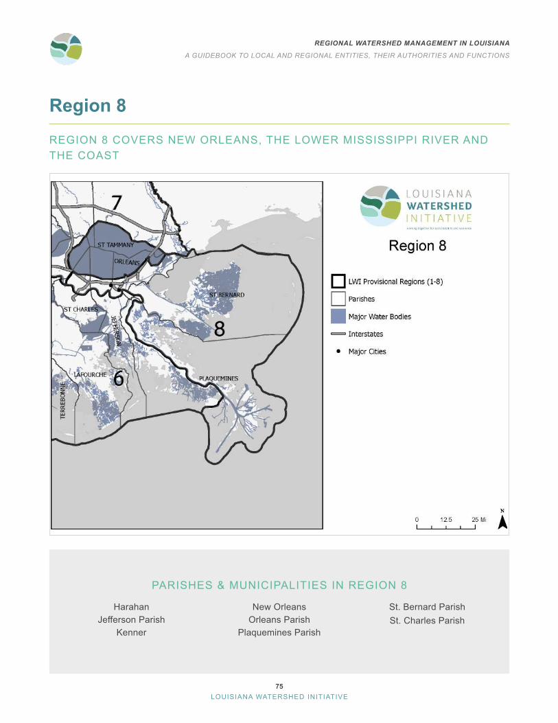
75
REGIONAL WATERSHED MANAGEMENT IN LOUISIANA
A GUIDEBOOK TO LOCAL AND REGIONAL ENTITIES, THEIR AUTHORITIES AND FUNCTIONS
LOUISIANA WATERSHED INITIATIVE
Region 8
REGION 8 COVERS NEW ORLEANS, THE LOWER MISSISSIPPI RIVER AND THE COAST
PARISHES & MUNICIPALITIES IN REGION 8
HarahanJefferson Parish
Kenner
New OrleansOrleans Parish
Plaquemines Parish
St . Bernard ParishSt . Charles Parish

76
REGIONAL WATERSHED MANAGEMENT IN LOUISIANA
A GUIDEBOOK TO LOCAL AND REGIONAL ENTITIES, THEIR AUTHORITIES AND FUNCTIONS
LOUISIANA WATERSHED INITIATIVE
REGION 8 WATER MANAGEMENT ENTITIESIn addition to the parishes and municipalities in Region 8, the table below contains a comprehensive list of the 13 other local and regional entities with water management functions.
Region 8 entities with water management authorityCoastal zone management
Jefferson Parish Coastal Zone Management ProgramOrleans Parish Coastal Zone Management ProgramPlaquemines Parish Coastal Zone Management ProgramSt . Bernard Parish Coastal Zone Management Program
Gravity drainage districtsSt . Charles Parish, Gravity Drainage District No . 2
Levee districtsLafitte Area Independent Levee DistrictLafourche Basin Levee DistrictSoutheast Louisiana Flood Protection Authority-East
Soil and water conservation districtsPlaquemines Soil and Water Conservation District
Planning and development districtsDistrict 1: New Orleans Regional Planning CommissionSouth Central Planning & Development District
Special districtsLakefront Management Authority
Navigation and waterway special districtsMississippi River Deepening Project
The provisional watershed regions
and their associated regional steering
committees recognized by the
Council on Watershed Management play
important roles in the Louisiana Watershed Initiative . However, they do not have legal authority to
provide the functions identified for regional watershed coalitions .
One of their goals is to understand the authorities of the existing
entities and make recommendations
to improve regional watershed
management .

77
REGIONAL WATERSHED MANAGEMENT IN LOUISIANA
A GUIDEBOOK TO LOCAL AND REGIONAL ENTITIES, THEIR AUTHORITIES AND FUNCTIONS
LOUISIANA WATERSHED INITIATIVE
The table below compares selected entities in Region 8 and their authorities and functions.
Sou
thea
st L
ouis
iana
Flo
od P
rote
ctio
n A
utho
rity-
Eas
t
Pla
quem
ines
Soi
l and
W
ater
Con
serv
atio
n D
istri
ct
New
Orle
ans
Reg
iona
l P
lann
ing
Com
mis
sion
Par
ish/
mun
icip
al g
over
ning
aut
horit
ies
AUTHORITY FUNCTION
Standards development and enforcement
Building and development code
Local building code amendments Establish standards beyond statewide code to reduce flood risk
Building code enforcementPermit review, site inspection and/or rule-making functions for development with water management impacts
Land use regulations
Adopt new land use and zoning standards
Establish standards or processes to require water management provisions
Enforce land use and zoning standards
Permit review, site inspection and/or rule-making functions for development with water management impacts
Inspect construction sites and developed sites and issue stop work orders, corrective action orders and/or fines
Integrated planning
Watershed management planning
Develop and adopt watershed management plan
Develop and adopt watershed plans with authority to establish floodplain management standards
Develop and adopt watershed plans with authority to prioritize projects and project funding
Local plan reviewReview, revise and approve local plans in accordance with regional or state watershed management standards
Floodplain mapping and delineation
Authority to measure and define floodplains
Delineate floodplain boundaries
Determine floodplain expansion areas
Conduct official watershed hydrologic assessments for planning purposes

78
REGIONAL WATERSHED MANAGEMENT IN LOUISIANA
A GUIDEBOOK TO LOCAL AND REGIONAL ENTITIES, THEIR AUTHORITIES AND FUNCTIONS
LOUISIANA WATERSHED INITIATIVE
Sou
thea
st L
ouis
iana
Flo
od P
rote
ctio
n A
utho
rity-
Eas
t
Pla
quem
ines
Soi
l and
W
ater
Con
serv
atio
n D
istri
ct
New
Orle
ans
Reg
iona
l P
lann
ing
Com
mis
sion
Par
ish/
mun
icip
al g
over
ning
aut
horit
ies
AUTHORITY FUNCTION
Sustainable funding and implementation
Recurring revenue
Funding Taxing authority
Financing Bonding authority
Project implementation
Project design and construction
Design and construct water management projects
Design and construct water management projects throughout the entire region
Operation and maintenance Operate and maintain drainage or water management infrastructure
Land acquisition Acquire, hold and steward real property

79
REGIONAL WATERSHED MANAGEMENT IN LOUISIANA
A GUIDEBOOK TO LOCAL AND REGIONAL ENTITIES, THEIR AUTHORITIES AND FUNCTIONS
LOUISIANA WATERSHED INITIATIVE
MAPS OF SELECT ENTITIES WITH KEY WATER MANAGEMENT FUNCTIONS
Region 8Levee
Districts

80
REGIONAL WATERSHED MANAGEMENT IN LOUISIANA
A GUIDEBOOK TO LOCAL AND REGIONAL ENTITIES, THEIR AUTHORITIES AND FUNCTIONS
LOUISIANA WATERSHED INITIATIVE
Region 8Planning and Development
Districts

81
REGIONAL WATERSHED MANAGEMENT IN LOUISIANA
A GUIDEBOOK TO LOCAL AND REGIONAL ENTITIES, THEIR AUTHORITIES AND FUNCTIONS
LOUISIANA WATERSHED INITIATIVE
Region 8Water
Districts

82
REGIONAL WATERSHED MANAGEMENT IN LOUISIANA
A GUIDEBOOK TO LOCAL AND REGIONAL ENTITIES, THEIR AUTHORITIES AND FUNCTIONS
LOUISIANA WATERSHED INITIATIVE
Region 8 Governance AnalysisParish and municipal governing authorities have the most authority related to the development and execution of watershed management plans and projects in Region 8 . However, these governing authorities are limited in their use of that authority to their jurisdictional boundaries, such as a city, gravity drainage district or parish . Parish and municipal governments can voluntarily coordinate on regional initiatives across jurisdictional boundaries through formal agreements such as cooperative endeavor agreements or memoranda of understanding, however, these efforts sometimes face difficulties ensuring broad participation or can vary in their effectiveness based on changes to local ordinances or levels of support from local administrations .
Other than parish and municipal governing authorities, the Southeast Louisiana Flood Protection Authority has the most authority related to the implementation of flood control projects. However, the SLFPA (East and West) is limited to its district boundaries, which do not cover all of Region 8, and to constructing and maintaining flood protection systems.
Region 8 includes both the South Central Planning & Development Commission and the New Orleans Regional Planning Commission . By far, the NORPC covers the largest geographic area within the region . Both entities deliver externally funded programs, promote coordination, offer technical assistance and planning services within their established district boundaries and have broad authority to implement projects . However, they cannot develop or enforce higher standards or codes .
REGION 8 GAP ANALYSIS Existing versus potential authorities for regional watershed coalitions
Entity type
Develop and adopt watershed
plans Regulate
development
Develop and enforce higher
standards
Fund, construct, operate and
maintain flood risk reduction projects
Authority to operate throughout entire watershed region
Parish/municipal governing authorities
Planning and development districts
Levee districts
Water districts
Navigation districts
It should be noted that there are a few key functions that are not
provided by any entity in the region:
Review, revise and approve local plans in accordance with regional or state watershed management standards on behalf of the region
Delineate floodplain boundaries
Determine floodplain expansion areas
Design and construct projects throughout the entire region
None of the entities researched have clear authority to provide
the above functions.

83
REGIONAL WATERSHED MANAGEMENT IN LOUISIANA
A GUIDEBOOK TO LOCAL AND REGIONAL ENTITIES, THEIR AUTHORITIES AND FUNCTIONS
LOUISIANA WATERSHED INITIATIVE
Statewide Gap Analysis
A multitude of entities in Louisiana have some authority related to water management . However, none have the authority to perform the regional watershed management functions identified in earlier studies . Every entity is limited in authority, purpose and jurisdiction . This creates gaps in the ability for any one entity to manage water and flood risk at the watershed region level. Furthermore, many entities have overlapping geographies and authorities, making it unclear which entities are responsible for leading which elements of water management in their jurisdictions .
Parish and municipal governing authorities have the most authority to create and execute watershed management plans by enforcing development regulations and implementing projects . By their nature, however, these governing authorities are limited to their jurisdictional boundaries, such as a city, parish or district, in terms of their authority to develop and execute watershed management plans.
Beyond parish and municipal governing authorities, every provisional watershed region has at least one entity with the authority to implement and maintain flood control projects, such as levee districts and conservation districts . These districts are also limited to their jurisdictional boundaries and specific purposes, which make it difficult to coordinate project planning and implementation and to leverage their dedicated funding for projects that provide benefits beyond the specific needs, purposes or geographies these districts were created to address .
Generally, planning and development districts have the broadest combination of jurisdiction, authority and purpose . In each watershed region, these districts cover the largest geographic areas . Planning and development districts deliver externally funded programs, promote regional coordination, offer technical assistance and planning services within their established district boundaries and have broad authority to fund and implement projects . However, these entities cannot develop and enforce higher standards, regulate development or develop and adopt watershed plans .
There are a few key functions not provided by any entity in any region, as none of them have clear authority to provide them:
• Review, revise and approve local plans in accordance with regional or state watershed management standards
• Delineate floodplain boundaries
• Determine floodplain expansion areas
• Design and construct projects throughout the region

84
REGIONAL WATERSHED MANAGEMENT IN LOUISIANA
A GUIDEBOOK TO LOCAL AND REGIONAL ENTITIES, THEIR AUTHORITIES AND FUNCTIONS
LOUISIANA WATERSHED INITIATIVE
Watershed management entities statewide
Leve
e di
stric
ts
Wat
er c
onse
rvat
ion
dist
ricts
Wat
ersh
ed s
peci
al d
istri
cts
Soi
l and
wat
er c
onse
rvat
ion
dist
ricts
Wat
erw
ay s
peci
al d
istri
cts
Pla
nnin
g an
d de
velo
pmen
t dis
trict
s
Par
ish/
mun
icip
al g
over
ning
au
thor
ities
AUTHORITY FUNCTION
Standards development and enforcement
Building and development code
Statewide building code amendments
Adopt new standards and/or amend existing standards to reduce flood risk
Local building code amendments
Establish standards beyond statewide code to reduce flood risk
Building code enforcement
Review and approve/decline proposed development applications
Inspect construction sites and developed sites and issue stop work orders, corrective action orders and/or fines
Land use regulations
Adopt new land use and zoning standards
Add or amend standards and processes to require flood risk reduction provisions
Enforce land use and zoning standards
Review and approve/decline proposed development applications
Inspect construction sites and developed sites and issue stop work orders, corrective action orders and/or fines
Integrated planning
Watershed management planning
Develop and adopt watershed management plans
Develop and adopt watershed plans with authority to establish floodplain management standards
Develop and adopt watershed plans with authority to prioritize projects and project funding
Local plan reviewReview, revise and approve local plans in accordance with watershed management standards
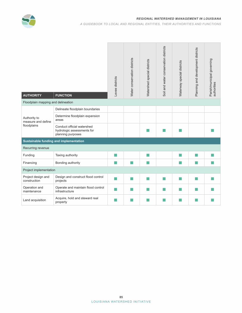
85
REGIONAL WATERSHED MANAGEMENT IN LOUISIANA
A GUIDEBOOK TO LOCAL AND REGIONAL ENTITIES, THEIR AUTHORITIES AND FUNCTIONS
LOUISIANA WATERSHED INITIATIVE
Leve
e di
stric
ts
Wat
er c
onse
rvat
ion
dist
ricts
Wat
ersh
ed s
peci
al d
istri
cts
Soi
l and
wat
er c
onse
rvat
ion
dist
ricts
Wat
erw
ay s
peci
al d
istri
cts
Pla
nnin
g an
d de
velo
pmen
t dis
trict
s
Par
ish/
mun
icip
al g
over
ning
au
thor
ities
AUTHORITY FUNCTION
Floodplain mapping and delineation
Authority to measure and define floodplains
Delineate floodplain boundaries
Determine floodplain expansion areas
Conduct official watershed hydrologic assessments for planning purposes
Sustainable funding and implementation
Recurring revenue
Funding Taxing authority
Financing Bonding authority
Project implementation
Project design and construction
Design and construct flood control projects
Operation and maintenance
Operate and maintain flood control infrastructure
Land acquisition Acquire, hold and steward real property