RECENT EFFORTS TO MITIGATE THE IMPACTS OF … · 01/08/2016 · resistance building design SNI...
10
This extended abstract has been presented as a Keynote Lecture in “Kyoto Seminar 2016 Development in Earthquake Geotechnics”, June 13-15, Kyoto University, Kyoto, Japan. RECENT EFFORTS TO MITIGATE THE IMPACTS OF EARTHQUAKE HAZARD IN INDONESIA FROM GEOTECHNICAL ENGINEERING PERSPECTIVE Hendriyawan 134 , Masyhur Irsyam 134 , M. Asrurifak 34 , Irwan Meilano 23 , L. M. Sakti 1 , Arif Sabaruddin 5 , Lutfi Faisal 5 1) Faculty of Civil and Environmental, Institute of Technology Bandung 2) Faculty of Earth Sciences and Technology, Institute of Technology Bandung 3) Research Center for Disaster Mitigation, Institute of Technology Bandung 4) Member of the Indonesian Society for Geotechnical Engineering (ISGE) 5) Center for Research and Development of Housing and Settlements, the Ministry of Public Works INTRODUCTION Indonesia has been well known as one of the most seismically active countries in the world since it is located on the boundaries of three major plates; Asian, India-Australia, and Pacific plates. The India-Australia plate converges northeastward about 50 to 70 mm/year to the Asian Plate along the Sunda trench (Bock et al, 2003). This tectonically dynamic environment puts most parts of Indonesia prone to earthquake and their secondary hazards such as tsunami, landslides, liquefaction, flood and fire. Considerable numbers of active faults are also identified on offshore and onshore of Indonesia such as Great Sumateran fault, Palu-Koro fault, Molucca fault, Sorong fault and many others. Lessons learned from several great earthquakes repeatedly occurred in Indonesia since the 2004 Aceh earthquake have increased the awareness to public and government regarding the impacts of seismic hazard on their structures such as buildings, bridges, dams, and any other critical facilities. Based on Irsyam et al (2013a), the estimated total losses due to the earthquake from 2004 to 2010 vary from US$39 million to US$4,745 million. In addition, almost 200,000 were killed due to the earthquakes activities. Over the last decade, many research agencies, universities, including professional associations have significantly increased the efforts to improve the understanding of earthquake phenomena and the predictive capabilities of earthquake science and to mitigate the impacts of future earthquakes in Indonesia. The recent efforts in Indonesia to mitigate the impacts of earthquake hazard from geotechnical engineering perspective which involving the Indonesian Society for Geotechnical Engineering (ISGE) and the Research Center for Disaster Mitigation (RCDM) of Institute of Technology Bandung (ITB) include several activities as follows: - Updating of seismic hazard maps of Indonesia 2010 and 2016 - Revision and continuous updating of building and infrastructure codes - Development of microzonation maps for big cities in Indonesia - Development of academic draft of National Earthquake Master Plan - Development of national code for geotechnics and earthquake - Preparation for establishment of the National Center for Earthquake Studies UPDATING OF SEISMIC HAZARD MAPS OF INDONESIA 2010 AND 2016
Transcript of RECENT EFFORTS TO MITIGATE THE IMPACTS OF … · 01/08/2016 · resistance building design SNI...
This extended abstract has been presented as a Keynote Lecture in “Kyoto Seminar
2016 Development in Earthquake Geotechnics”, June 13-15, Kyoto University, Kyoto,
Japan.
RECENT EFFORTS TO MITIGATE THE IMPACTS OF
EARTHQUAKE HAZARD IN INDONESIA FROM GEOTECHNICAL
ENGINEERING PERSPECTIVE
Hendriyawan134
, Masyhur Irsyam134
, M. Asrurifak34
, Irwan Meilano23
, L. M. Sakti1, Arif
Sabaruddin5, Lutfi Faisal
5
1) Faculty of Civil and Environmental, Institute of Technology Bandung
2) Faculty of Earth Sciences and Technology, Institute of Technology Bandung
3) Research Center for Disaster Mitigation, Institute of Technology Bandung
4) Member of the Indonesian Society for Geotechnical Engineering (ISGE)
5) Center for Research and Development of Housing and Settlements, the Ministry of Public Works
INTRODUCTION
Indonesia has been well known as one of the most seismically active countries in the world
since it is located on the boundaries of three major plates; Asian, India-Australia, and Pacific
plates. The India-Australia plate converges northeastward about 50 to 70 mm/year to the
Asian Plate along the Sunda trench (Bock et al, 2003). This tectonically dynamic
environment puts most parts of Indonesia prone to earthquake and their secondary hazards
such as tsunami, landslides, liquefaction, flood and fire. Considerable numbers of active
faults are also identified on offshore and onshore of Indonesia such as Great Sumateran fault,
Palu-Koro fault, Molucca fault, Sorong fault and many others.
Lessons learned from several great earthquakes repeatedly occurred in Indonesia since the
2004 Aceh earthquake have increased the awareness to public and government regarding the
impacts of seismic hazard on their structures such as buildings, bridges, dams, and any other
critical facilities. Based on Irsyam et al (2013a), the estimated total losses due to the
earthquake from 2004 to 2010 vary from US$39 million to US$4,745 million. In addition,
almost 200,000 were killed due to the earthquakes activities. Over the last decade, many
research agencies, universities, including professional associations have significantly
increased the efforts to improve the understanding of earthquake phenomena and the
predictive capabilities of earthquake science and to mitigate the impacts of future earthquakes
in Indonesia.
The recent efforts in Indonesia to mitigate the impacts of earthquake hazard from
geotechnical engineering perspective which involving the Indonesian Society for
Geotechnical Engineering (ISGE) and the Research Center for Disaster Mitigation (RCDM)
of Institute of Technology Bandung (ITB) include several activities as follows:
- Updating of seismic hazard maps of Indonesia 2010 and 2016
- Revision and continuous updating of building and infrastructure codes
- Development of microzonation maps for big cities in Indonesia
- Development of academic draft of National Earthquake Master Plan
- Development of national code for geotechnics and earthquake
- Preparation for establishment of the National Center for Earthquake Studies
UPDATING OF SEISMIC HAZARD MAPS OF INDONESIA 2010 AND 2016

The need to revise and to update the Indonesian Seismic Hazard Map 2002 was driven by
several great earthquake occurrences in Indonesia such as the 2004 Aceh Earthquake (Mw9.0-
9.3) which was followed by tsunami, the 2005 Nias Earthquake (Mw 8.7), and the 2009
Padang Earthquake (MW 7.6). In 2009, Ministry of Public Works has assigned eleven (11)
researches as a Team for Revision of Seismic Hazard Maps of Indonesia (TRSHMI 2010) to
revise the 2002 map. The team consists of several institutions in Indonesia such as: ITB;
Institute of Road Engineering Agency for Research and Development and Center for
Research and Development of Housing and Settlements of the Ministry of Public Works;
Indonesian Institute of Sciences (LIPI); Meteorological, Climatological and Geophysical
Agency (BMKG), and Geological Research and Development Center (GSC). The team also
collaborated with the United Stated Geological Survey (USGS) and the Australia-Indonesia
Facility for Disaster Reduction (AIFDR). Several issues such as recent seismic activities,
latest research works regarding fault characteristics in Indonesia, improvements of the
method in seismic hazard analysis and latest provisions in International Building Code
(ASCE 2010) have been considered in the development of the national hazard maps 2010.
Following TRSHMI 2010 (Irsyam et al., 2010, 2013a and 2013b), seismic sources were
classified into three types of source models; fault zone, subduction zone, and background
seismicity. Classification was conducted based on seismogenic conditions, focal mechanisms
and earthquake catalogs. The seismogenic conditions included geometry and
geomorphological of tectonic plate such as faults and subduction zones. Fault sources were
modeled as a plane in 3-D space for calculation of distance from a site to a certain point at the
plane. Subduction zone model were derived from tomography model conducted by
Widiyantoro (2009), historical earthquake catalogs and seismotectonic conditions.
Background seismicity was utilized to account for random earthquakes on unmapped faults
and smaller earthquakes on mapped faults. A type of background seismicity was gridded
models based on spatially smoothed earthquake rates (Frankel, 1995).
The fault model and subduction model utilized by TRSHMI 2010 is shown in Figure 1. The
hazard maps have been officially published and signed by the Minister of Public Work of
Indonesia in 2010 and implemented in a newly revised national code for earthquake
resistance building design SNI 1726-2012.
TRSHMI 2010 has also proposed recommendation to the government. The recommendations
include: conduct periodic updating of seismic hazard maps and related national codes every
three to five years; conduct micro seismicity investigation of active faults that have not been
well identified and well quantified, especially near big cities such as Jakarta, Surabaya,
Semarang; accelerate the installation of strong-motion accelerometer networks in Indonesia
in order to develop database of time histories and attenuation functions; and perform seismic
microzonation studies for big cities in Indonesia.
In order to follow up the recommendation from TRSHMI 2010, in 2015 The National
Agency for Disaster Management (BNPB) started coordinating several institutions in
Indonesia to update the national seismic hazard maps 2010. The team consists of experts
from ITB, BMKG, Center of Volcanology and Geological Hazard Mitigation (PVMBG),
Ministry of Public Works, LIPI, Geospatial Information Agency (BIG), Agency for the
Assessment and Application of Technology (BPPT), and professional associations such as
IABI. The team is divided into several working groups, such as geology, geodesy,
seismology, ground motion prediction equations, and Seismic Hazard Analysis. Important
information is considered for updating seismic hazard maps such as significant results of
recent active-fault studies utilizing trenching and carbon dating as well as availability of basic
data including the SRTM-30, IFSAR, LiDAr and other data that is just recently available. It

can be expected that this new information will result in more accurate tectonic model and
their seismic parameters, such as maximum magnitudes and slip-rates. This updating work is
currently on going and it is expected to be completed before end of 2016.
Fig. 1 Earthquake sources and their parameters used by TRSHMI 2010 (Irsyam et al., 2010,
and 2013a)
REVISION AND CONTINUOUS UPDATING OF BUILDING AND
INFRASTRUCTURE CODES
The Ministry of Public Works has practically implemented SNI 1726-2012 to replace SNI
03-1726-2002 as a national code for earthquake resistance building design since 2014. The
new code for buildings follows the concept of Maximum Considered Earthquake Geometric
Mean (MCEG) and Risk-Adjusted Maximum Considered Earthquake (MCER) used by ASCE
7-10. For the purpose of geotechnical calculation, it combines both the results from
probabilistic seismic hazard analysis for 2% probability of exceedance in 50 years (2,500
years earthquake) and deterministic seismic hazard analysis for area located near active fault.
Both approaches were utilized according to the procedure proposed by Leyendecker et al.
(2000) and the result of combining both probabilistic and deterministic analyses is called
MCEG.
In order to evaluate the seimic hazard for low and high risk structure (e.g. building), the
spectral acceleration maps are required. The 0.2s and 1.0s spectral acceleration maps have
been developed by taking into account the probability of collapse for a structure. Probability
of collapse of a structure is influenced by the structural capacity that has uncertainty
including as site-to-site variability in the shape of hazard curve, material properties,
nonstructural components, etc that will result in a lack of uniformity in structural capacity
(Luco, 2006). For the new national code, probability of collapse of a structure is targeted to
be equal to 1% in 50 years according to ASCE 7-10. Figure 2 and 3 show the maps of Risk-
Adjusted Maximum Considered Earthquake (MCER) at 0.2s and 1.0s spectral response
acceleration in SNI 1726-2012.
Updating of national standards for design of infrastructure is also conducted for bridges,
dams, harbours, tunnels, and others special structures. It seems that each type of
infrastructure code will utilize hazard maps having different return period of earthquake. For

design of bridge, updating of the code is already completed. The standard RSNI2 2833:201X
that follows AASHTO LRFD Bridge Design Specification, 5th Edition, 2012 utilize return
period of earthquake equals to approximately 1000 years that corresponds to 7% probability
of exceedance in 75 years. Based on the new code, three maps of spectral response
accelerations are required to develop the design response spectra, i.e. spectral acceleration at
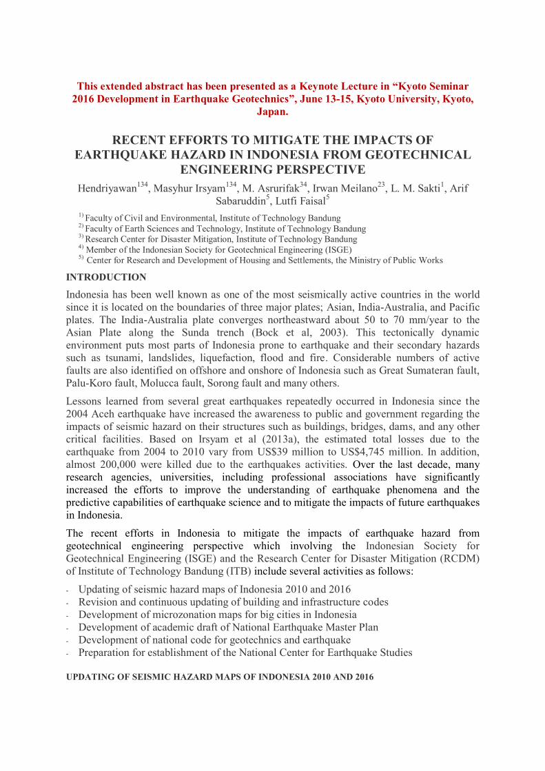
0.0s, 0.2s, and 1.0s. The hazard maps for T=0.2s for site class SB can be seen in Figure 4.The
code is already in the Indonesian Standardization Body and expected to be launched by the
end of 2016.
Fig. 22 Map of Risk-Targeted Maximum Consider Earthquake (MCER) at bedrock (SB)
of Indonesia at 0.2s spectral response acceleration in SNI 1726-2012 for building design
Fig. 3 Map of Risk-Targeted Maximum Consider Earthquake (MCER) at bedrock (SB) of
Indonesia at 1.0s spectral response acceleration in SNI 1726-2012 for building design
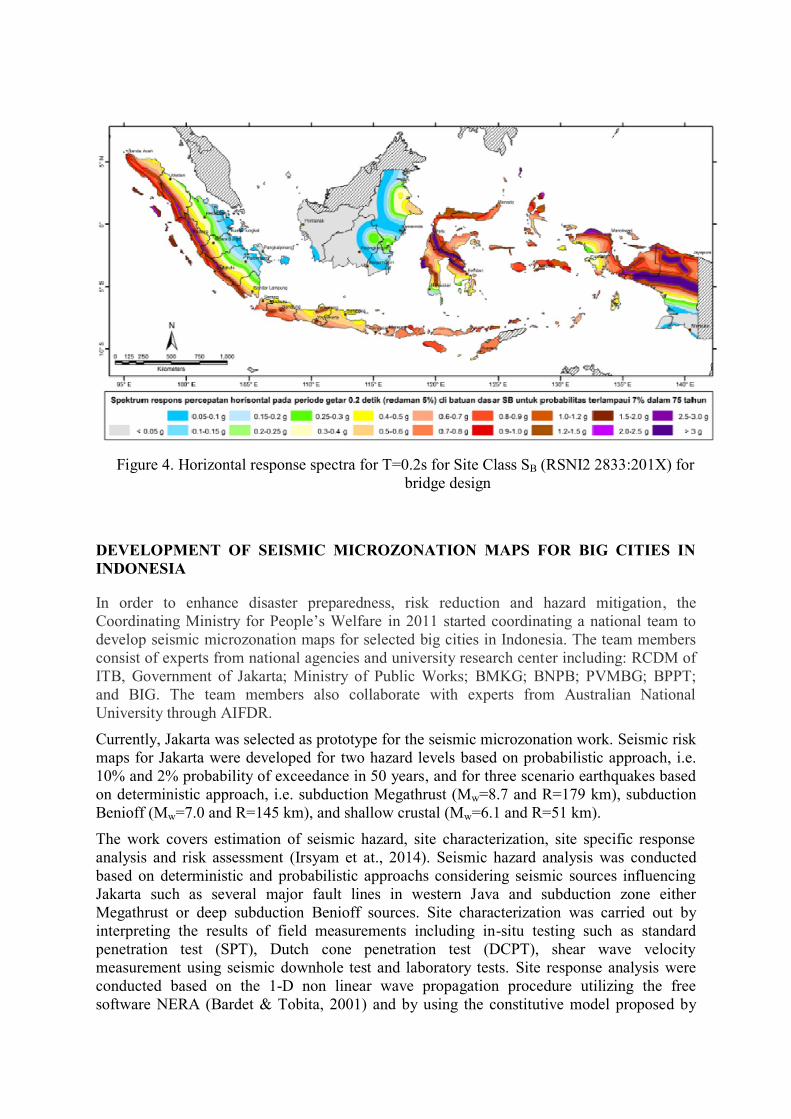
Figure 4. Horizontal response spectra for T=0.2s for Site Class SB (RSNI2 2833:201X) for
bridge design
DEVELOPMENT OF SEISMIC MICROZONATION MAPS FOR BIG CITIES IN
INDONESIA
In order to enhance disaster preparedness, risk reduction and hazard mitigation, the
Coordinating Ministry for People’s Welfare in 2011 started coordinating a national team to
develop seismic microzonation maps for selected big cities in Indonesia. The team members
consist of experts from national agencies and university research center including: RCDM of
ITB, Government of Jakarta; Ministry of Public Works; BMKG; BNPB; PVMBG; BPPT;
and BIG. The team members also collaborate with experts from Australian National
University through AIFDR.
Currently, Jakarta was selected as prototype for the seismic microzonation work. Seismic risk
maps for Jakarta were developed for two hazard levels based on probabilistic approach, i.e.
10% and 2% probability of exceedance in 50 years, and for three scenario earthquakes based
on deterministic approach, i.e. subduction Megathrust (Mw=8.7 and R=179 km), subduction
Benioff (Mw=7.0 and R=145 km), and shallow crustal (Mw=6.1 and R=51 km).
The work covers estimation of seismic hazard, site characterization, site specific response
analysis and risk assessment (Irsyam et at., 2014). Seismic hazard analysis was conducted
based on deterministic and probabilistic approachs considering seismic sources influencing
Jakarta such as several major fault lines in western Java and subduction zone either
Megathrust or deep subduction Benioff sources. Site characterization was carried out by
interpreting the results of field measurements including in-situ testing such as standard
penetration test (SPT), Dutch cone penetration test (DCPT), shear wave velocity
measurement using seismic downhole test and laboratory tests. Site response analysis were
conducted based on the 1-D non linear wave propagation procedure utilizing the free
software NERA (Bardet & Tobita, 2001) and by using the constitutive model proposed by
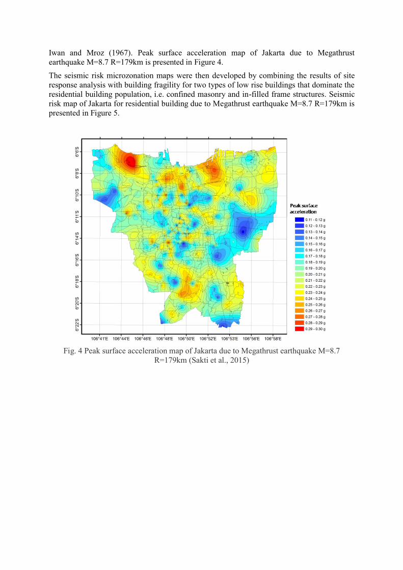
Iwan and Mroz (1967). Peak surface acceleration map of Jakarta due to Megathrust
earthquake M=8.7 R=179km is presented in Figure 4.
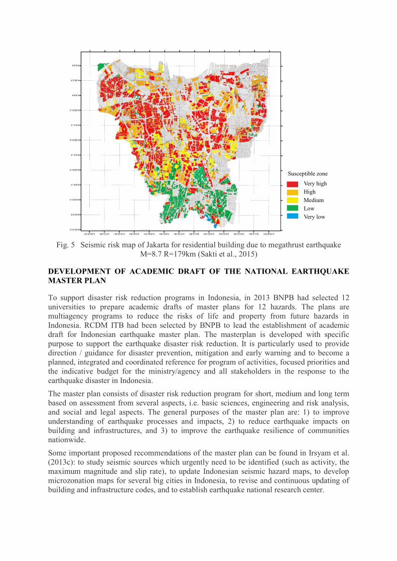
The seismic risk microzonation maps were then developed by combining the results of site
response analysis with building fragility for two types of low rise buildings that dominate the
residential building population, i.e. confined masonry and in-filled frame structures. Seismic
risk map of Jakarta for residential building due to Megathrust earthquake M=8.7 R=179km is
presented in Figure 5.
Fig. 4 Peak surface acceleration map of Jakarta due to Megathrust earthquake M=8.7
R=179km (Sakti et al., 2015)
Very high
High
Medium
Low
Very low
Susceptible zone
Fig. 5 Seismic risk map of Jakarta for residential building due to megathrust earthquake
M=8.7 R=179km (Sakti et al., 2015)
DEVELOPMENT OF ACADEMIC DRAFT OF THE NATIONAL EARTHQUAKE
MASTER PLAN
To support disaster risk reduction programs in Indonesia, in 2013 BNPB had selected 12
universities to prepare academic drafts of master plans for 12 hazards. The plans are
multiagency programs to reduce the risks of life and property from future hazards in
Indonesia. RCDM ITB had been selected by BNPB to lead the establishment of academic
draft for Indonesian earthquake master plan. The masterplan is developed with specific
purpose to support the earthquake disaster risk reduction. It is particularly used to provide
direction / guidance for disaster prevention, mitigation and early warning and to become a
planned, integrated and coordinated reference for program of activities, focused priorities and
the indicative budget for the ministry/agency and all stakeholders in the response to the
earthquake disaster in Indonesia.
The master plan consists of disaster risk reduction program for short, medium and long term
based on assessment from several aspects, i.e. basic sciences, engineering and risk analysis,
and social and legal aspects. The general purposes of the master plan are: 1) to improve
understanding of earthquake processes and impacts, 2) to reduce earthquake impacts on
building and infrastructures, and 3) to improve the earthquake resilience of communities
nationwide.
Some important proposed recommendations of the master plan can be found in Irsyam et al.
(2013c): to study seismic sources which urgently need to be identified (such as activity, the
maximum magnitude and slip rate), to update Indonesian seismic hazard maps, to develop
microzonation maps for several big cities in Indonesia, to revise and continuous updating of
building and infrastructure codes, and to establish earthquake national research center.
DEVELOPMENT OF THE NATIONAL CODE FOR GEOTECHNICS AND
EARTHQUAKE
Development of the Indonesia's national code for geotechnics and earthquake has been
initiated in 2014 by the Ministry of Public Works. The main purpose of the project is to
establish a code as the Indonesian national standard for the design of construction works
related to geotechnics and earthquake. The developed code will cover sub structures for
buildings, highways, bridges, water resources and settlements. The committee for this work
consists of ISGE, Institute of Road Engineering Agency for Research and Development,
Research and Development Center for Water Resources, Center for Research and
Development of Housing and Settlements, and universities.
The code will provide common structural design rules to be used for design of sub structures
including the requirements for field and laboratory tests. There are nine (9) fields that will be
covered by the code as follows: 1) Stability of Slope and Embankment, 2) Deep Excavation,
3) Foundation, 4) Tunnel, 5) Seismicity, 6) Geotechnical Investigation, 7) Retaining
Structure, 8) Ground Improvement, and 9) Hydraulic failure. All standards in the code are
developed by a consensus standards process such as focus group discussion (FGD) organized
by ministry of public works and ISGE. Development of the code is currently on going and
expected for completion by the end of 2016.
PREPARATION FOR ESTABLISHMENT OF THE NATIONAL CENTER FOR
EARTHQUAKE STUDIES
Based upon the academic draft of Indonesia earthquake master plan (Irsyam, et.al, 2013c), a
national center for earthquake research is urgently needed to support disaster risk reduction
programs in Indonesia. The center is required to enhance the science and practice of
earthquake science and engineering and to improve the understanding of the impact of
earthquakes on the physical, social, and economic. The center will gather scientists and
engineers from different institutions at national level to share and integrate all data, resources,
knowledge and new scientific findings in earthquake hazards through collaborative
researches.
The establishment of the research center was initiated at the end of 2015 by several
Indonesian institutions such as: Ministry of Public Works; ITB; BMKG; LIPI; PVMBG;
BIG; BNPB; Ministry of Research, Technology and Higher Education; BPPT; Universities
(UNDIP, UGM, and ITS); and profesional associatons (ISGE, IABI, and AFMI).The research
center will cover the following tasks such as: conduct basic and applied researches related to
earthquake hazard and risk; support and perform the updating of seismic hazard and risk
maps periodically and sustainably; develop standards, manual and guidelines related to
seismic hazard and risks; and coordinate and synchronize with the ministry/agency and other
institutions regarding all the activities related to monitoring systems, measurement, and
seismic characteristics analysis for supporting the updating of national hazard maps and
earthquake risk. In order to fulfill the tasks, the research center is supported by eight (8)
working groups, i.e. geology, geodesy, seismology, ground motion prediction equation
(GMPE), seismic hazard analysis, geotechnics, infrastructures and structures, and collateral
hazards. It is expected that the national research center to be launched in this year (2016).
CONCLUSIONS
Lessons learned from several great earthquakes repeatedly occurred in Indonesia since the
2004 Aceh earthquake have increased the awareness to public and government regarding
seismic activities in Indonesia. Over the last ten years, many research institutions,
universities, including association professions such as Indonesian Society for Geotechnical
Engineering (ISGE) have significantly increased the efforts to understand earthquake hazards
and to mitigate the impact of future large earthquakes in Indonesia. Some of the recent efforts
in Indonesia to mitigate the impacts of earthquake hazards were described briefly in this
paper. The actions includes updating of the seismic hazard maps of Indonesia 2010 and 2016,
revision and continuous updating of building and infrastructure codes, development of
microzonation maps for big cities in Indonesia, development of academic draft of Indonesian
Earthquake Master Plan, development of a national code for geotechnics and earthquake, and
establishment of the national center for earthquake studies.
REFERENCES
AASHTO LRFD Bridge Design Specification, 2012
ASCE 7 (2010). Minimum design loads for buildings and other structures, American Society
of Civil Engineers, Reston, VA.
Bardet , J.P. and Tobita, T. (2001) : NERA A Computer Program for Nonlinear Earthquake
site Response Analyses of Layered Soil Deposits, Departement of Civil Engineering
University of Southern California.
Bock, Y. et al. (2003) Crustal motion in Indonesia from Global Positioning System
measurements, J. Geophys. Res. 108.
Frankel, A. (1995) Mapping Seismic Hazard in the Central and Eastern United States:
Seismological Research Letters, Vol. 66, no.4, 1995, pp. 8-21.
Irsyam, M., Sengara, I.W., Asrurifak, M., Ridwan, M., Aldiamar, F., Widiyantoro, S.,
Triyoso, W., Natawijaya, D.H., Kertapati, E., Meilano, I., and Suhardjono (2010),
Summary: Development of Seismic Hazard Maps of Indonesia for Revision of Seismic
Hazard Map in SNI 03-1726-2002. Research report submitted to the Ministry of Public
Works by Team for Revision of Seismic Hazard Maps of Indonesia, July.
Irsyam, M., Hendriyawan, Asrurifak, M., Razali, R., and Firmanti, A. (2011). Combined
Hazards: Seismic Hazard maps of Indonesia and Geotechnical and Tsunami Hazard
Assessment for Banda Aceh. Geotechnical and Earthquake Geotechnics towards Global
Sustainability’ edited by Susumu Iai, ISBN 978-94-007-0469-5, Springer.
Irsyam, M., Hendriyawan, Asrurifak, M., Ridwan, M., Aldiamar, F., Sengara, I.W.,
Widiyantoro, S., Triyoso, W., Natawijaya, D.H., Kertapati, E., Meilano, I., Suhardjono,
and Firmanti, A. (2013a). Past Earthquakes in Indonesia and New Seismic Hazard Maps
for Earthquake Design of Buildings and Infrastructures. Geotechnical Predictions and
Practice in Dealing with Geohazards. Edited by Chu, Jian, Wardani, S.P.R., and Lizuka,
A., ISBN 978-94-007-5674-8, Springer.
Irsyam, M., Sengara, I.W., Asrurifak, M., Ridwan, M., Aldiamar, F., Widiyantoro, S.,
Triyoso, W., Natawijaya, D.H., Kertapati, E., Meilano, I., Suhardjono, Hutabarat, D.,
Sidi, I.D., and Merati, W. (2013b), Development of Seismic Hazard and Risk Maps for
New Seismic Building and Infrastructure Codes in Indonesia. Proceeding the 6th Civil
Engineering Conference in Asia Region: Embracing the Future through Sustainability,
20-22 August 2013, Jakarta, ISBN 978-602-8605-08-3.
Irsyam, M., Widiyantoro,S., Imran, I., Rahayu, H., Hendriyawan, Puspito, N.T., Meilano, I.
Hutapea, B.M., Nugraha, A.D. (2013c) Rencana Induk (Master Plan) Penanggulangan
Risiko Bencana Gempabumi. Prosiding Seminar Nasional Riset Kebencanaan.
Mataram, 8-10 Oktober 2013
Irsyam, M, Hutabarat, D., Asrurifa, M., Imran, I., Widiyantoro, S., Hendriyawan, Afriansyah,
T., Pindratmo, H., Firmanti, A., Ridwan, M., Haridjono, S.W., Pandhu, R. (2014)
“Development of Seismic Risk Microzonation Maps of Jakarta City”, Proceedings, 4th
International Conference on Geotechnical Engineering for Disaster Mitigation and
Rehabilitation (4th GEDMAR), September 16-18, Kyoto University, Japan, edited by
Susumu Iai, ISBN 978-1-138-02709-1, Taylor&Francis Group, London.
Iwan, W.D. (1967): On A Class of Models for The Yielding Behavior of Continuous and
Composite Systems, Journal of Applied Mechanics, ASME, Vol. 34:612-617.
Leyendecker, E.V., Hunt, R.J., Frankel, A.D., and Rukstales, K.S. (2000), Development of
Maximum Considered Earthquake Ground Motion Maps, Earthquake Spectra, Volume
16, No. 1., pp. 21-40.
Rancangan Standar Nasional Indonesia (2015). Perancangan Jembatan terhadap Beban
Gempa (RSNI 2833:201X). Badan Standardisasi Nasional.
Sakti, L.M., Irsyam, M., Asrurifak, M., Imran, I., Alfriansyah, T. (2015) Analysis Study of
Risk Map in Jakarta induced by Megathrust Scenario Earthquake. 10th
Indonesian
Geotechnical Conference and 19th
Annual Scientific Meeting, Jakarta.
Standar Nasional Indonesia (2002), Tata Cara Perencanaan Ketahanan Gempa untuk
Bangunan Gedung dan Non Gedung (SNI 03 1726-2002), Badan Standardisasi Nasional.
Standar Nasional Indonesia (2012), Tata Cara Perencanaan Ketahanan Gempa untuk
Bangunan Gedung dan Non Gedung (SNI 1726-2012), Badan Standardisasi Nasional.
Widiyantoro, S. (2009), Seismicity and Structure of Lithosperic Slab Beneath The Sunda Arc,
Indonesia, SE Asian Gateway Evolution International Conference, 14-17 September,
Royal Holloway University of London.