RAPID Facility Team - DesignSafe-CI
9
7/9/2018 1 NSF Award Number: CMMI 1611820 Introduction to Natural Hazards Reconnaissance with the RAPID Facility Joe Wartman RAPID Facility Workshop 17 May 2018, Miami, Florida Director, RAPID Facility University of Washington RAPID Facility Team 2 Kurtis Gurley (UF), Wind Hazards Specialist Jennifer Irish (VT), Coast Hazards Specialist Laura Lowes (UW), Structural Engineering Specialist Jeffrey Berman (UW), Site Operation Director Scott Miles (UW), Social Science Specialist Michael Olsen (OSU), Technical Director Ann Bostrom (UW), Social Science Specialist Troy Tanner (UW‐APL), IT and Data Director Jake Dafni (UW), Site Operations Manager Joseph Wartman (UW), Director
Transcript of RAPID Facility Team - DesignSafe-CI

7/9/2018
1
NSF Award Number: CMMI 1611820
Introduction to Natural Hazards Reconnaissance with the RAPID Facility
Joe Wartman RAPID Facility Workshop
17 May 2018, Miami, Florida Director, RAPID Facility
University of Washington
RAPID Facility Team
2
Kurtis Gurley (UF), Wind Hazards SpecialistJennifer Irish (VT), Coast Hazards SpecialistLaura Lowes (UW), Structural Engineering SpecialistJeffrey Berman (UW), Site Operation DirectorScott Miles (UW), Social Science SpecialistMichael Olsen (OSU), Technical DirectorAnn Bostrom (UW), Social Science SpecialistTroy Tanner (UW‐APL), IT and Data DirectorJake Dafni (UW), Site Operations Manager Joseph Wartman (UW), Director
7/9/2018
2
RAPID Facility Mission and Values
The RAPID facility provides investigators with the equipment, software, and support services needed to collect, process, and analyze perishable data from natural hazard events. The facility supports natural hazard and disaster researchers through training and educational activities, field deployment services, and facilitating engagement between scientists, engineers, stakeholders, and the public.
We promote reconnaissance‐based science, shared resources, open data, interdisciplinary research, community engagement, and innovation to reduce the adverse impacts of natural hazards.
3
RAPID Facility Strategic Activities
To achieve its mission, the RAPID facility engages in the following strategic activities.
Acquiring, maintaining, and operating state‐of‐the‐art data collection equipment
Developing and supporting mobile applications to support interdisciplinary field reconnaissance
Providing advisory services and basic logistics support for research investigations
Facilitating the systematic archiving, processing and visualization of acquired data in DesignSafe‐CI
Training a broad user base through workshops and other activities
Engaging the public through citizen science, as well as through community outreach and education
4
7/9/2018
3
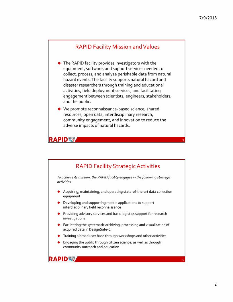
RAPID Timeline
5
Year 1Community Input and Resource Requirement Development
Year 2Acquisition,
Commissioning and Training
Years 3‐5User Service,
Field Operations, Continued Training
September 2016‐September 2017
• Developing facility headquarters• Hiring staff (site operations, IT,
administrative)• Workshop • Science plan revision• Specification development• Trial equipment deployment and
testing • NHERI summer institute• Coordination with DesignSafe• Facility operating documents• Outreach via conference
presentations• Mobile app development• Citizen science app development and
workshop
September 2017‐September 2018
• Procurement and commissioning• Staff training• Facility operating plan and site users
manual• User training workshops (4)• REU program• IT cyber security• RApp development and testing• Fiscal operating plan• Proposal support
September 2018 and beyond
• Supporting field missions and data use/reuse
• Training• Maintenance
Natural Hazard Reconnaissance in the U.S.

7/9/2018
4
Value of Natural Hazard Reconnaissance Data
• Data generated by an extreme event is unique and often highly "perishable" —and thus, must be collected quickly
• Disaster data sets include the real‐world complexities (e.g., interplay between natural, human, and built systems) that allow us to better understand and to quantify the socio‐technical dimensions related to damage, restoration, and resiliency of the built environment
• Such data is difficult to duplicate in the laboratory
• These data can be used to:‐ develop new, fundamental discoveries and insights‐ test and verify simulation models‐ reduce uncertainties in probabilistic models‐ inspire next generation simulation models
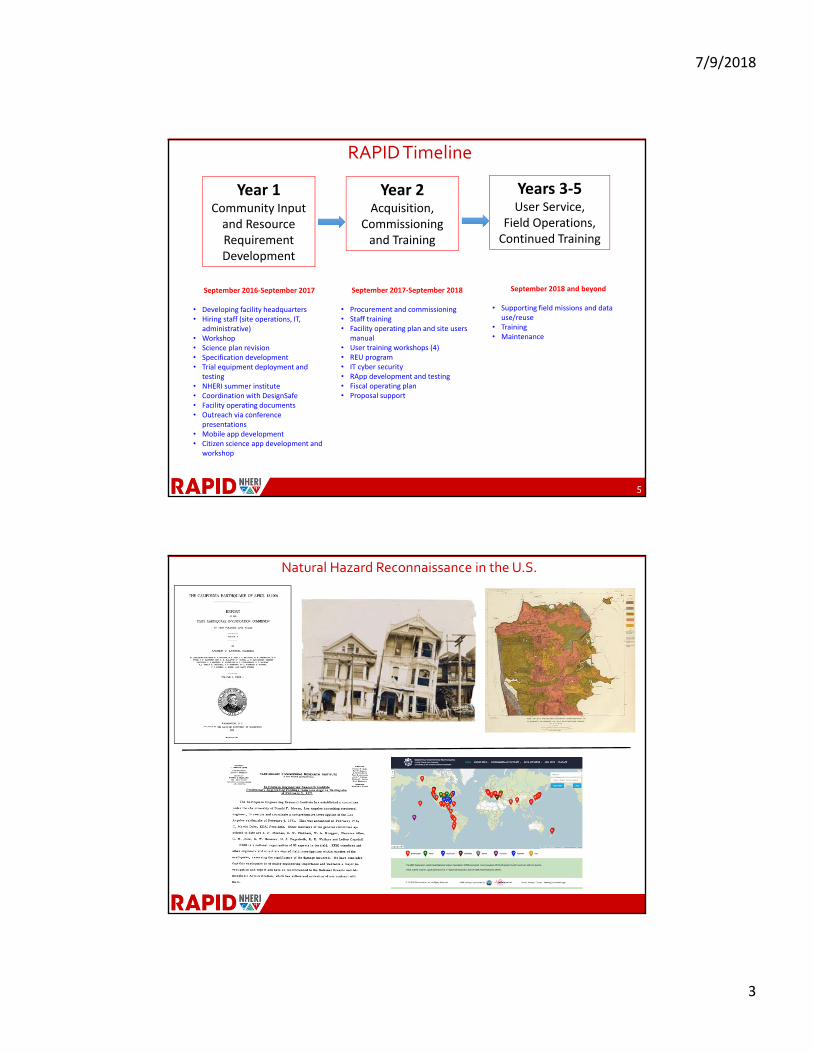
Enabling the Next Generation of Natural Hazards Reconnaissance
Courtesy of J. Bray, (2017) Ishihara Lecture, Simplified procedure for estimating liquefaction‐induced building settlement
• Fundamental insights
• Critical data for validation
• Lots of highly perishable data
• 2D “point" data
• Manual measurements
• 10 cm resolution
7/9/2018
5
Enabling the Next Generation of Natural Hazards Reconnaissance
• Large amount of high‐quality data
• High‐resolution (<1 cm), systematic data collection
• 3D (and 4D)
• Automation
• Geo‐referenced data sets that can be later analyzed and interrogated
• Open data archived in DesignSafe
Enabling the Next Generation of Natural Hazards Reconnaissance
10

7/9/2018
6
Enabling the Next Generation of Natural Hazards Reconnaissance
Tsunami Inundation
Enabling the Next Generation of Natural Hazards Reconnaissance
Example Eyewitness Interview Transcript

7/9/2018
7
Enabling the Next Generation of Natural Hazards Reconnaissance
Enabling the Next Generation of Natural Hazards Reconnaissance
Vertical displacement
Relative freq
uen
cy

7/9/2018
8
Complementing Laboratory Instrumentation
Obtain 3D high‐ resolution point cloud models for NHERI experiments
o Record damage
o Determine precise instrument locations
o Benchmark experiments to field observations
o Develop damage detection and load history determination methods
15
NHERI UCSD Shaking Table Experiment
RAPID Facility Science Plan
The principal scientific goal of the RAPID is to:
Inform natural hazards computational simulation models, infrastructure performance assessment, and socioeconomic impact analysis by supporting the collection, development, and assessment of high‐quality disaster data sets
Grand Challenges for Natural Hazards Engineering (after National Academies report)
• Community Resilience Framework
• Hazard and Impact Simulation and Decision Making
• Mitigation
• Design Tools

7/9/2018
9
Science Plan: Strategic Approaches –Acquire and integrate data over a range of temporal and spatial scales, across disciplines
Science Plan: Strategic Approaches –Acquire and integrate data over a range of temporal and spatial scales, across disciplines