R2508 Land Use Study - Kern County, California · R-2502E, R-2505, R-2506, ... What is a Joint Land...
216
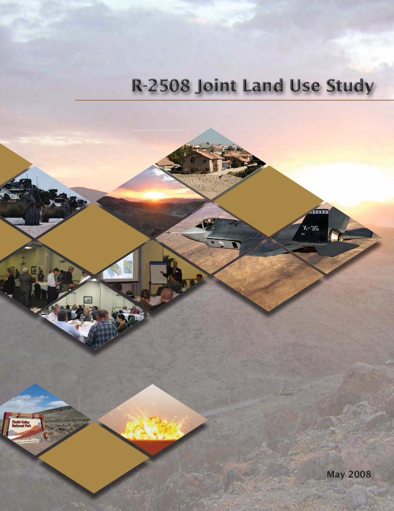
May 2008
Transcript of R2508 Land Use Study - Kern County, California · R-2502E, R-2505, R-2506, ... What is a Joint Land...
May 2008


R‐2508 Joint Land Use Study
State of California Arnold Schwarzenegger, Governor Governor’s Office of Planning and Research Cynthia Bryant, Director, OPR 1400 Tenth Street Sacramento, CA 95814 Terry Roberts, Director, State Clearinghouse Ned McKinley, California JLUS Project Manager May 2008

This study was prepared under contract with the Governor's Office of Planning and Research,
on behalf of the State of California, with financial support from the Office of Economic
Adjustment, Department of Defense. The content reflects the views of the Governor's Office
of Planning and Research, on behalf of the State of California and does not necessarily reflect
the views of the Office of Economic Adjustment.
As local sponsor of this study, Kern County provided financial assistance, policy guidance, and
technical support to the Governor’s Office of Planning and Research.
Please feel free to reproduce all or part of this document. You need not secure permission; we
ask that you print it accurately and give credit to the Governor’s Office of Planning and
Research.
This document is available on the Internet at:
http://www.opr.ca.gov


ACKNOWLEDGEMENTS
JLUS CONSULTANTS:
Celeste Werner, AICP
Richard Rust, AICP
Molly Bosley, AICP
Michael Hrapla
Todd Tamburino
Robin Main
OPR STAFF:
Terry Roberts, Director, State Clearinghouse
Ned McKinley, California JLUS Project Manager
Julia Lave Johnston, Senior Planner
Jennifer Driemeyer, Administrative Support
Chris Kinne, Project Support
ADVISORY COMMITTEE:
The Advisory Committee played an active and important
role in the development of the R‐2508 JLUS. OPR would like
to thank the following individuals for their support and
professional advice:
Carl Benz Assistant Field Supervisor, Desert Division, U.S. Fish and Wildlife Service
Jim Bilyeu Supervisor, County of Inyo
Patrick Christman Marine Corps Installations West
Phil Cox Supervisor, County of Tulare
Frank Crom Mayor Pro Tem, City of Bishop
Philip Crosbie Director of Strategic Planning, National Training Center
Dwight Deakin Chief, Airspace and Encroachment Branch, R‐2508 Complex Control Board
Russ Dingman Acting Mojave Sector Supervisor, California Department of Parks and Recreation
Delia Dominguez Chairperson, Kitanemuk and Yowlumne Tejon Indians
Michael Edmiston Council Member, City of California City
Gregg Fauth Wilderness Coordinator, Sequoia and Kings Canyon National Park Service
Charley Glasper Council Member, City of Adelanto
Stanley Grady Director of Development Services, City of Bakersfield
Ed Grimes Mayor, City of Tehachapi
Charles Holloway Manager of Environmental Assessment, Los Angeles Department of Water and Power
Javier Kinney Cultural Resources Policy Manager, San Manuel Band of Serrano Mission Indians
Gary Kuwabara Program Manager, Office of Economic Adjustment
Tom Lackey Councilmember, City of Palmdale
Ray Marler Director, Strategic Programs, National Training Center/Fort Irwin (former)
Jon McQuiston Supervisor, County of Kern

ACKNOWLEDGEMENTS
ADVISORY COMMITTEE: (continued)
Kathryn Montes Morgan Chairperson, Tejon Indian Tribe
Steven Morgan Mayor Pro Tempore, City of Ridgecrest
Patricia Morris Assistant to the City Manager, City of Barstow (former)
John O'Gara Director of Environmental Programs, Naval Air Weapons Station China Lake
Anthony Parisi Head, Sustainability Office, NAVAIR Ranges
Diana Pietrasanta Outdoor Recreation Planner, Bureau of Land Management, Bishop
Denyse Racine Senior Environmental Scientist, California Department of Fish and Game, Region 6
Hank Rigol Sustainability Officer, Air Force Flight Test Center/ Edwards AFB
Mike Rothschild Mayor, City of Victorville
Bob Sagona Councilman, Town of Apple Valley
Bruce Shaffer Associate District Manager, Bureau of Land Management
Ed Sileo Vice Mayor, City of Lancaster
Annette Tenneboe Environmental Scientist, California Department of Fish and Game, Region 4
John Valenzuela Chairman, San Fernando Band of Mission Indians
Hector Villalobos Field Office Manager, Bureau of Land Management, Ridgecrest
Col. Joe Wendel Colonel, USMC, Marine Corps Installations West
Margaret Wood Deputy District Ranger, Inyo National Forest
TECHNICAL COMMITTEE:
The Technical Committee played an active and important
role in the development of the R‐2508 JLUS. OPR would like
to thank the following individuals for their support and
professional advice:
Mike Armstrong Southern California Association of Governments (SCAG)
Patricia Arons Manager of Transmission Projets, Southern California Edison Co.
Howard Auld Chairman, IWV 2000
Jan Bennett CEO, Ridgecrest Chamber of Commerce
Jill Board Vice President, Student Services, Cerro Coso Community College
Ray Bransfield Biologist, U.S. Fish and Wildlife Service
Ann Brierty Cultural Resources Field Manager, San Manuel Band of Serrano Mission Indians (Environmental Department)
Dave Bryant Division Manager, Special Projects, County of Tulare (Resource Management Agency)
Diane Carlton Government Affairs Director, Greater Antelope Valley Association of Realtors
Bill Christian Amargosa River Project Director, The Nature Consrvancy
Charles Church Palmdale Chamber of Commerce
Nadia Dale Environmental Specialist, Los Angeles Department of Water and Power

ACKNOWLEDGEMENTS
TECHNICAL COMMITTEE: (continued)
John Dalton NEPA Specialist, Bureau of Land Management
Cassie Daniels Executive Vice President, Building Industry Association of Kern County
Dave Dawson Senior Associate Planner, County of San Bernardino
Allen De Salvio Mojave Desert Air Quality Management District
Russ Dingman Acting Mojave Sector Supervisor, California Department of Parks and Recreation
Delia Dominguez Kitanemuk & Yowlumne Tejon Indians
Ed Duggan Oak Creek Energy
David Eriksen California Association of Realtors (Coldwell Banker Best Realty)
Gregg Fauth Wilderness Coordinator, Sequoia and Kings Canyon National Park Service
Eric Flodine Vice President of Community Planning, Strata Equity Group
Stanley Grady Director of Development Services, City of Bakersfield
Tanda Gretz Senior Planner, County of Inyo (Planning Department)
Arlene Grider President, Independence Chamber of Commerce
Gretchen Gutierrez Executive Officer, BIA/Antelope Valley Chapter
Bruce Hafenfeld President, California Cattlemen's Association
Terry Hansen Marine Corps Installations West
Michelle Huck Community Planner, Edwards Air Force Base
Dave James Community Development Director, City of Tehachapi
Robert Johnstone Executive Director, Edwards Community Alliance
Becky Jones California Department of Fish and Game, Region 6
David Jones Air Pollution Control Officer, Kern County Air Pollution Control District
Mike Jones Planning and Policy, Southern California Association of Governments (SCAG)
Joseph Kinnally CALIBRE Site Manger, National Training Center / Fort Irwin
Cori Kitchen Senior Business Developer, Kern Economic Development Corporation
Gary Kuwabara Program Manager, Office of Economic Adjustment
Laurie Lile Assistant City Manager, City of Palmdale
Brian Ludicke Director of Community Development, City of Lancaster
Josh Mann Executive Director, Antelope Valley Board of Trade
Jim McRea Public Service Director, City of Ridgecrest
Ahmed Mohsen Land Management Consultant, Oak Creek Energy / Kern Wind Energy Association
Patricia Morris Assistant to the City Manager, City of Barstow (former)
Karen Northcutt City of California City
John O'Gara Director of Environmental Programs, Naval Air Weapons Station
Kristen Orr Project Manager, Presidential Management Fellow, Office of Economic Adjustment
Lorelei Oviatt Planning Division Chief, County of Kern
Anthony Parisi Head, Sustainability Office, NAVAIR Ranges
Linda Parker Executive Director, Kern Wind Energy Association
ACKNOWLEDGEMENTS
TECHNICAL COMMITTEE: (continued)
Rob Peterson Director, Planning and Entitlements, Tejon Ranch Company
Carol Randall Barstow Area Chamber of Commerce and Visitors Bureau
Becky Reynolds Principal Planner, Town of Apple Valley
Hank Rigol Chair, Encroachment Prevention and Management Committee, Plans and Policies Division, Air Force Flight Test Center / Edwards AFB
Suzanna Rogan County of Los Angeles
Patricia Russell Assistant Deputy to Supervisor Michael Antonovich, Los Angeles County Board of Supervisors (former)
Randy Scott Advanced Planning Division Chief, County of San Bernardino
Paul Sippel ED Manager, Kern County Community and Economic Development
Mike Skuja California Representative, Defenders of Wildlife, California Regional Office
Robert Snoddy Regional Planner III, Kern Council of Governments
Peter Soderquist Director, City of Victorville (Southern California Logistics Airport)
Jim Squire Supervising Planner, County of San Bernardino
Wade Tallman China Lake Defense Alliance
Annette Tenneboe Environmental Scientist, California Department of Fish and Game, Region 4
John Valenzuela Chairman, San Fernando Band of Mission Indians
Jeannie Verdugo President, Kern River and Lake Isabella Association of Realtors
Frank Williams Chief Executive Officer, BIA/Baldy View Chapter
Don Zdeba Superintendent, Lake Operations, Indian Wells Valley Cooperative Groundwater Management Working Group

MMMMMMMMMMMMMMMMMMaaaaaaaaaaayyyyyyyyyy 22222222000000000000000000000008888888888888888888888888888888888888888888888
E X E C U T I V E S U M M A R Y

2
Th e overall goal of a JLUS is to reduce potential confl icts while accommodating growth, sustaining the economic health of the region, and protecting public health and safety. Like all JLUS programs, the R-2508 JLUS has three primary objectives.
1) UnderstandingConvene community, agency, and military representatives to study the issues in an open forum, taking into consideration both community and military viewpoints and needs. Th is includes public outreach and input.
2) CollaborationEncourage cooperative land use and resource planning between the military and surrounding communities so that future community growth and development are compatible with the training and operational missions in the R-2508 Complex while at the same time seeking ways to reduce operational impacts on adjacent lands.
3) ActionsProvide a set of tools, activities, and procedures from which local jurisdictions, agencies, and the military can select, and then use to implement the recommendations developed during the JLUS process. Th e actions proposed include both operational measures to mitigate military impacts and local government and agency approaches to reduce impacts on R-2508 Complex operations.
The R-2508 Complex includes three mil i tary Installations:
Naval Air Weapons Station (NAWS) China Lake • Edwards Air Force Base (AFB)• Fort Irwin / National Training Center (NTC)•
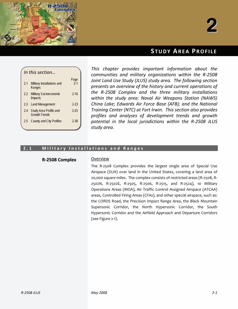
Th e R-2508 Complex provides the largest single area of Special Use Airspace (SUA) over land in the United States, covering a land area of 20,000 square miles. Th e R-2508 Complex consists of restricted areas (R-2508, R-2502N, R-2502E, R-2505, R-2506, R-2515, and R-2524), 10 Military Operations Areas (MOA), Air Traffi c Control Assigned Airspace (ATCAA) areas, Controlled Firing Areas (CFAs), and other special airspace such as, the CORDS Road, the Precision Impact Range Area, the Black Mountain Supersonic Corridor, the North Hypersonic Corridor, the South Hypersonic Corridor, and the Airfi eld Approach and Departure Corridors.
A Joint Land Use Study ( JLUS) is a collaborative planning effort between active military installations, surrounding counties and cities, and other aff ected agencies. Th e JLUS
process is funded by a grant from the Department of Defense Offi ce of Economic Adjustment (OEA).
The OEA is funding the preparation of two JLUSs in California. Given the large areas covered by these studies and the number of jurisdictions and agencies involved, the California JLUS program is being managed by the Governor’s Offi ce of Planning and Research (OPR). Th e two geographic study areas included in the California JLUS program are referred to as the R-2508 JLUS and the Beale JLUS.
The R-2508 JLUS is designed to address a study area comprised of all lands beneath the R-2508 Complex or in the vicinity of the three participating installations. Within the R-2508 JLUS study area are portions of Inyo, Kern, Los Angeles, San Bernardino, and Tulare counties, and the cities of California City, Ridgecrest, and Tehachapi. A large portion of the 20,000-square-mile study area is managed by
federal agencies, including U.S. National Parks (26.8%), Bureau of Land Management (BLM) (24.6%), military (17.4%), and U.S. National Forests (13.0%).
federal ageencies, includding UU.S.Natiional PParks (226.8%)), Bureeauof LLand MManageementt (BLMM)(24.66%), mmilitaryy (17.44%), aandU.S. Nationnal Forrests (113.0%)).
Aisbsuo
f d d b
What is a Joint Land Use Study?
Th e California JLUS Program
Goals and Objectives
R-2508 Complex-Overview

3
Management of the R-2508 Complex is organized in three groups: R-2508 Joint Policy and Planning Board ( JPPB), R-2508 Complex Control Board (CCB), and the R-2508 Central Coordinating Facility (CCF).
NAWS China Lake The installation currently serves as the host for the Naval Air Warfare Center Weapons Division (NAWCWD) under the Naval Air Systems Command (NAVAIR). It serves as a station for the research, development, test and evaluation of weapons.
Edwards AFB Edwards AFB supports the mission of the Air Force to guard the United States in its global interests through the use of superior defense systems in air, space and cyberspace.
Fort Irwin / NTC Th e NTC provides arms training in interagency, intergovernmental and multi-national venues to prepare brigade combat teams for combat.
As communities develop and expand in response to growth and market demands, land use decisions can push urban development closer to military installations and operational areas. Th is can result in land use and other compatibility issues, often referred to as encroachment. Encroachment can have negative impacts on community safety, economic development, and sustainment of military activities and readiness. At the same time, military activities can negatively impact the surrounding communities through factors such as noise, limits to renewable resources, and the use of local government services (i.e., roads, housing, and schools).
Th e R-2508 Complex is strategically important to the nation. It is an important national military asset with capabilities for weapons research and development, and an arena for realistic military training. Th e proximity of the Point Mugu Sea Range (located over the Pacifi c Ocean) combined with the inland mountains and desert open spaces of the R-2508 Complex, provide the premier, instrumented setting for conducting warfare testing and training exercises.
Military installations typically have a signifi cant positive economic impact on adjacent communities. Th ey add to the economic base of a region through direct expenditures (salaries to employees, purchases of services and supplies, contracts, etc.) and secondary eff ects (jobs and income created by increased activity in the economy from direct expenditures and suppliers to primary industries). For some areas, the local economy is driven by military expenditures, and fl uctuations in spending can notably impact the local economy. Th e economic impact of the R-2508 Complex on the region is signifi cant (see next page).
Military installations and local communities are also linked through the services each provides. With many military personnel and their families living in nearby communities, local jurisdictions and agencies provide a range of services to these personnel from libraries to police and fi re protection. Military personnel and their family members receive medical care from local health care providers, enroll in local schools and colleges, and shop local retail and commercial establishments. Community support programs and events further connect the installation to the community and region. The military installations within the R-2508 Complex continue to enjoy an atmosphere of mutual respect, cooperation, strong teamwork, and common interest in economic enhancement with their local communities. The installations also support local communities by responding with critical services when needed, such as fi re response, explosive ordnance disposal, and other emergency services.
R-2508 Complex-National Importance
R-2508 Complex-Local Importance
Marine Corps CH-46 Sea Knight over China Lake
Armored Vehicle Convoy
RQ-4 Global Hawk at Edwards AFB
Community Housing
MMMMMMMMMMM t f tth R 2508 CC ll i i d i tth

4
China Lake In 2007, China Lake was the largest employer in the Indian Wells Valley, providing jobs for 767 military personnel, 3,388 civilian employees, and over 2,400 contractor staff . Th e annual payroll at China Lake was $432 million. Over 91 percent of the total payroll was to civilians. Annual contract expenditures totaled $531 million.
Edwards AFB In Fiscal Year 2006 (FY06), the base employed 11,111 persons including 3,209 military personnel and 7,902 civilians and contractor personnel. Th e installation had an economic impact of $1.4 billion in FY06. Th is fi gure includes $536 million in payroll, $267 million in contract expenditures, and $575 million in indirect jobs created for almost 12,000 local residents.
Fort Irwin / NTC As reported for November 2007, the installation employed 5,170 active duty, Reserve, and National Guard military and 3,469 civilians. Depending on training cycles and unit composition, rotational units training at the NTC can add another 4,000 to 5,000 people to the total installation population. Fort Irwin / NTC is the top employer in the Barstow area and the third highest employer in San Bernardino County. Civilian payroll is estimated at $27.6 million and military payroll is about $86.8 million. Fort Irwin awards an estimated $241 million in contracts annually, which employs approximately 12,000 contractors.
Cities, counties, Native American tribal governments, state and federal agencies and military installations within the region of the R-2508 Complex have been actively engaged and proactive in local and regional encroachment / compatible land use management for many years. Th rough the JLUS
process, they will continue to partner to ensure that future community growth and development are compatible with the training and operational missions of the installations. Th ese partners will also continue to seek ways to reduce the operational impacts of military installations on adjacent land.
Th e goal of the R-2508 JLUS is to protect the viability of current and future missions in the R-2508 Complex while at the same time accommodating growth, sustaining the economic health of the region, and protecting public health and safety.
Th e R-2508 JLUS is not an adopted plan, but rather, a recommended set of compatibility guidelines that can be implemented by local jurisdictions, Native American tribal governments, agencies and organizations to guide their future compatibility eff orts. While the strategies in the JLUS are not mandatory obligations, they were developed with representatives of the stakeholders involved, thereby providing a set of strategies designed to meet local needs.
Following completion of the R-2508 JLUS, local jurisdictions, agencies and organizations can work towards implementation of the strategies that apply to them. For instance, local jurisdictions can use the strategies to guide future general plan and zoning updates. Edwards AFB, China Lake and Fort Irwin / NTC can use the JLUS to guide their eff orts in compatibility planning as well. It is through the future actions of the stakeholders involved that the JLUS strategies will become a reality.
Th e following is a brief overview of the organization of the R-2508 JLUS.
1. Introduction Section 1 provides an introduction and context for the R-2508 JLUS. It describes the goals and objectives used to guide development of the JLUS, who was involved in developing the JLUS, public outreach methods, and the organization of the study.
2. Study Area Profi le In developing a JLUS, a good understanding of the installations, military training areas, and local jurisdictions within the study area is necessary. Th is section provides an overview of the R-2508 Complex’s history, descriptions of the primary installations that use the Complex, a look at the current missions and military units located at those installations, the economic impact of the installations on the region, and a discussion of future missions. An overview of the region’s growth potential and a profi le of each of the counties and cities within the study area, including population, housing, and employment statistics are also provided.
R-2508 JLUS Summary
R-2508 JLUS
Partnerships
CCttrffeiintthaacllR-2508 JLUS Committee
meeting

5
3. Existing Plans, Studies and Programs Th is section provides an overview of currently available and relevant plans, programs, and studies, which are used to address compatibility issues in the study area. Th is includes technical studies, as well as local general plans and zoning ordinances.
4. Recommendations The final section of the JLUS provides a toolbox of strategies to address the compatibility issues identifi ed. Th e recommended strategies have been developed cooperatively with representatives from local jurisdictions, participating
military installations, Native American tribal governments, state and federal agencies, local organizations, and interested individuals and landowners. As a result of a collaborative planning process, the recommendations in this section represent a true consensus plan: a realistic, coordinated approach to compatibility planning developed with the support of the stakeholders involved.
5. Acronyms A listing, with defi nitions, of the acronyms used in the JLUS.
6
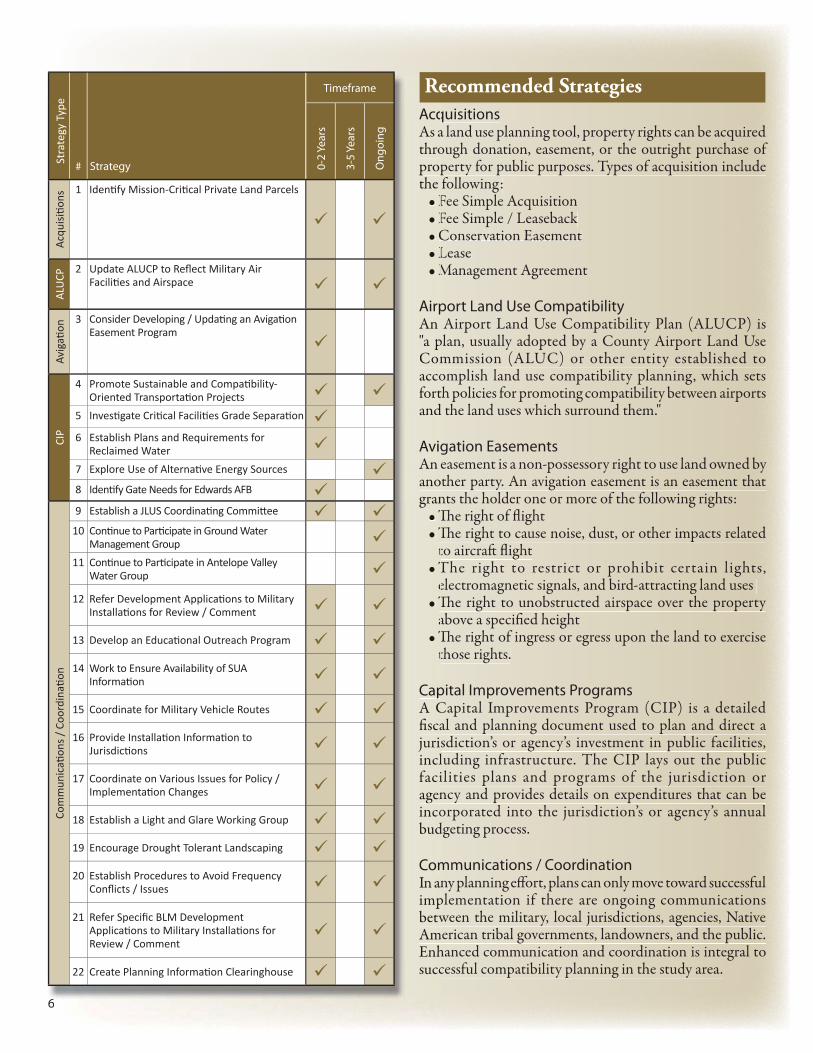
Acquisitions As a land use planning tool, property rights can be acquired through donation, easement, or the outright purchase of property for public purposes. Types of acquisition include the following:
Fee Simple Acquisition• Fee Simple / Leaseback• Conservation Easement• Lease• Management Agreement•
Airport Land Use Compatibility An Airport Land Use Compatibility Plan (ALUCP) is "a plan, usually adopted by a County Airport Land Use Commission (ALUC) or other entity established to accomplish land use compatibility planning, which sets forth policies for promoting compatibility between airports and the land uses which surround them."
Avigation Easements An easement is a non-possessory right to use land owned by another party. An avigation easement is an easement that grants the holder one or more of the following rights:
Th e right of fl ight • Th e right to cause noise, dust, or other impacts related • to aircraft fl ight The right to restrict or prohibit certain lights, • electromagnetic signals, and bird-attracting land uses Th e right to unobstructed airspace over the property • above a specifi ed height Th e right of ingress or egress upon the land to exercise • those rights.
Capital Improvements ProgramsA Capital Improvements Program (CIP) is a detailed fi scal and planning document used to plan and direct a jurisdiction’s or agency’s investment in public facilities, including infrastructure. The CIP lays out the public facilities plans and programs of the jurisdiction or agency and provides details on expenditures that can be incorporated into the jurisdiction’s or agency’s annual budgeting process.
Communications / CoordinationIn any planning eff ort, plans can only move toward successful implementation if there are ongoing communications between the military, local jurisdictions, agencies, Native American tribal governments, landowners, and the public. Enhanced communication and coordination is integral to successful compatibility planning in the study area.
6
AcqAs athropropthe
F•F•C•L•M•
AirpAn "a pComaccofortand
AvigAn anogran
Th•Th•tT•eTh•aTh•t
CapA Cfi scajuriinclfaciagenincobud
ComIn animpbetwAmEnhsucc
Timeframe
# Strategy 0-2
Year
s
3-5
Year
s
Ong
oing
Acq
uisiti o
ns
1 Identi fy Mission-Criti cal Private Land Parcels
ALU
CP
2 Update ALUCP to Refl ect Military Air Faciliti es and Airspace
Avig
ati o
n 3 Consider Developing / Updati ng an Avigati on Easement Program
CIP
4 Promote Sustainable and Compati bility-Oriented Transportati on Projects
5 Investi gate Criti cal Faciliti es Grade Separati on
6 Establish Plans and Requirements for Reclaimed Water
7 Explore Use of Alternati ve Energy Sources
8 Identi fy Gate Needs for Edwards AFB
Com
mun
icati
ons
/ C
oord
inati
on
9 Establish a JLUS Coordinati ng Committ ee
10 Conti nue to Parti cipate in Ground Water Management Group
11 Conti nue to Parti cipate in Antelope Valley Water Group
12 Refer Development Applicati ons to Military Installati ons for Review / Comment
13 Develop an Educati onal Outreach Program
14 Work to Ensure Availability of SUA Informati on
15 Coordinate for Military Vehicle Routes
16 Provide Installati on Informati on to Jurisdicti ons
17 Coordinate on Various Issues for Policy / Implementati on Changes
18 Establish a Light and Glare Working Group
19 Encourage Drought Tolerant Landscaping
20 Establish Procedures to Avoid Frequency Confl icts / Issues
21 Refer Specifi c BLM Development Applicati ons to Military Installati ons for Review / Comment
22 Create Planning Informati on Clearinghouse
Recommended StrategiesSt
rate
gy T
ype

7
Deed Restrictions / CovenantsDeed restrictions, or covenants, are written agreements that restrict or limit some of the rights associated with property ownership. Th ese restrictions are recorded with the deed for the property and stay with the property when it is sold to a new owner (i.e., remain in eff ect).
General Plans / Management PlansEvery city and county in California is required by state law to prepare and maintain a policy document called a general plan. General plans are designed to serve as the jurisdiction’s blueprint for future decisions concerning physical development, including land use, infrastructure, public services, and resource conservation. All specifi c plans, subdivisions, public works projects, and zoning decisions made by the local government must be consistent with the general plan.
Habitat Conservation ToolsTh e California Natural Community Conservation Planning Act and the Federal Endangered Species Act allow for the development of Natural Community Conservation Plans (NCCP) and Habitat Conservation Plans (HCP). An NCCP identifi es and provides for the regional or areawide protection of plants, animals, and their habitats, while allowing compatible and appropriate economic activity.
Legislative InitiativesA variety of legislative initiatives at the federal, state, and local levels can be used to enhance the sustainability of military installations and ranges. Th ese initiatives aim to mitigate incompatible land uses or impacts of military operations on protected lands.
Light and Glare ControlsLight pollution is defi ned as any adverse eff ect of light, including sky glow, glare, light trespass, light clutter, decreased visibility at night, and energy waste. Light pollution and excessive glare can have negative impacts on military operations in the R-2508 Complex, as well as on the natural environment and local communities.
Memorandum of UnderstandingA Memorandum of Understanding (MOU) is a contract between two or more government entities. Th e governing bodies of the participating public agencies must take appropriate legal actions, oft en adoption of an ordinance or resolution, before such agreements become eff ective. Th ese agreements are also known as Joint Powers Agreements or Interlocal Agreements.
7
Timeframe
# Strategy 0-2
Year
s
3-5
Year
s
Ong
oing
Com
mun
icati
ons
/ C
oord
inati
on
(con
ti nue
d)
23 Encourage Cellular Tower Collocati on / Consolidati on
24 Work to Ensure Marking of Uti lity Lines
25 Allow Military Review of Permit Applicati ons
26 Work to Evaluate Use of Existi ng Transmission Corridors
27 Review / Amend Controlled Burn Procedures
28 Investi gate Providing Guidance on Tower Locati on / Height
29 Address Confl icts with High Speed Rail and Highway Projects
30 Require Planning Coordinati on with Military
31 Partner for BLM Lands
32 Review Operati onal Guidelines for the Controlled Firing Area
Cove
nant
s 33 Consider Developing an Enhanced Real Estate Disclosure Ordinance
Gen
eral
Pla
ns /
Man
agem
ent P
lans
34 Review of Management Plans for Military Compati bility
35 Ensure Water Impacts in Plan Development / Updates
36 Involve Military in General Plan Update Process
37 Evaluate Willow Springs Specifi c Plan Uses
38 Consider Developing Methods to Address Frequency Spectrum Confl icts
39 Evaluate Rosamond Land Use Changes for Traffi c Impacts
40 Consider Evaluati ng Urban / Rural Interface
41 Investi gate Infi ll and Densifi cati on
42 Include Military Housing Needs Discussion in General Plan Housing Element
43 Evaluate Ridgecrest Sphere of Infl uence
44 Evaluate California City Sphere of Infl uence
45 Encourage Trip Reducti on Techniques
Stra
tegy
Typ
e

8
Military Installation OperationsMilitary installations maintain numerous formal documents to aid in standardization of procedures and processes to ensure consistent and safe operations and mission completion. For fl ight operations in and around the R-2508 Complex, these documents include, but are not limited to each installation’s fl ight standards operating procedure manuals and the R-2508 Complex Users Handbook.
Military Operations AreaTh e R-2508 Complex supports a diverse range of military operations. As such, these areas should be assigned areas of interest designations that reflect the unique aspects and impacts of the supported operations. Assigning these designations would provide added insights into the operations conducted in these areas, as well as land use compatibility. Areas of interest designations would ultimately aid in the development of local jurisdictions’ planning documents within the JLUS study area (i.e., general and specifi c plans).
Real Estate DisclosurePrior to the transfer of real property to a new owner, California law requires sellers and their agents to disclose all known facts related to the condition of the property. Th is disclosure should include noise or other proximity impacts associated with property located near a military installation or operations area.
Zoning / Subdivision / Other Local RegulationsZoning is the division of a jurisdiction into districts (zones) within which permissible uses are prescribed and restrictions on building height, bulk, layout, and other requirements are defi ned.
Land cannot be divided in California without local government approval. Dividing land for sale, lease or fi nancing is regulated by local ordinances based on the State Subdivision Map Act. Subdivision ordinances set forth the minimum requirements deemed necessary to protect the health, safety, and welfare of the public.
8
MiliMilito ato ecomComto eaman
MiliTh e operof inandthesthe use ultimplanand
ReaPrioCaliknowdisclassoor op
ZonZonwithon bare d
Langovefi nanSubdminheal
Timeframe
# Strategy 0-2
Year
s
3-5
Year
s
Ong
oing
Hab
itat 46 Implement Regional Habitat Conservati on
Plan
Legi
slati
ve 47 Protecti ng Military Missions with Wilderness
Legislati on
Ligh
t 48 Determine Dark Sky Funding Sources
MO
U
49 Evaluate Implementati on of Military Emission Reducti on System
50 Coordinate Military Ordnance Use and Locati on
Mili
tary
Inst
Ops 51 Evaluate Rerouti ng of Military Flight Patt erns
Mili
tary
Ops
Are
a 52 Develop Area of Interest Designati ons for Operati ons Areas
Real
Est
ate
53 Provide UXO Informati on
54 Develop / Modify Disclosure Noti ces for Military Operati ons
Zoni
ng
55 Use Subdivision Regulati ons to Minimize Impacts
56 Determine Density Limitati ons Needs
57 Consider Evaluati ng Use of China Lake Military Overlay District
58 Consider Developing Regulati ons to Address Verti cal Obstructi ons
59 Consider Developing Solar Power Generati on Guidelines
60 Remove Residenti al Tower Exempti ons
61 Identi fy and Miti gate Dust Constraints
Stra
tegy
Typ
e
For More InformationThe complete JLUS document can be downloaded from the OPR website at: www.opr.ca.gov
Table of Contents
R‐2508 JLUS May 2008 i
1. Introduction 1.1 What i s a Jo int Land Use Study? . . . . . . . . . . . . . . . . . . . . . . . . . . . . .1 ‐6 1.2 Why Prepare a Jo int Land Use Study? . . . . . . . . . . . . . . . . . . . . .1 ‐7 1.3 JLUS Object ives . . . . . . . . . . . . . . . . . . . . . . . . . . . . . . . . . . . . . . . . . . . . . . . . . . . .1 ‐8 1.4 Publ ic Outreach . . . . . . . . . . . . . . . . . . . . . . . . . . . . . . . . . . . . . . . . . . . . . . . . . . .1 ‐8 1.5 JLUS Implementat ion . . . . . . . . . . . . . . . . . . . . . . . . . . . . . . . . . . . . . . . . . . 1 ‐13 1.6 JLUS Organizat ion . . . . . . . . . . . . . . . . . . . . . . . . . . . . . . . . . . . . . . . . . . . . . . 1 ‐13
2. Study Area Profile
2.1 Mil itary Insta l lat ions and Ranges . . . . . . . . . . . . . . . . . . . . . . . . . . .2 ‐1 2.2 Mil itary Socioeconomic Impacts . . . . . . . . . . . . . . . . . . . . . . . . . . . 2 ‐16 2.3 Land Management . . . . . . . . . . . . . . . . . . . . . . . . . . . . . . . . . . . . . . . . . . . . . . 2 ‐23 2.4 Study Area Prof i le and Growth Trends . . . . . . . . . . . . . . . . . . 2 ‐25 2.5 County and City Prof i les. . . . . . . . . . . . . . . . . . . . . . . . . . . . . . . . . . . . . . 2 ‐38
3. Existing Plans, Studies, and Programs
3.1 Insta l lat ion Plans . . . . . . . . . . . . . . . . . . . . . . . . . . . . . . . . . . . . . . . . . . . . . . . . .3 ‐2 3.2 Local Jur isdict ion Planning Tools . . . . . . . . . . . . . . . . . . . . . . . . . . . .3 ‐6 3.3 Other Agency Plans . . . . . . . . . . . . . . . . . . . . . . . . . . . . . . . . . . . . . . . . . . . . 3 ‐21 3.4 Cal i forn ia Compatib i l i ty Handbook . . . . . . . . . . . . . . . . . . . . . . . 3 ‐29 3.5 Legis lat ion and Other Regulat ions . . . . . . . . . . . . . . . . . . . . . . . . 3 ‐30 3.6 Other Resources . . . . . . . . . . . . . . . . . . . . . . . . . . . . . . . . . . . . . . . . . . . . . . . . 3 ‐36
4. Recommendations
4.1 Developing Recommendat ions . . . . . . . . . . . . . . . . . . . . . . . . . . . . . . .4 ‐1 4.2 Recommended JLUS Strategies . . . . . . . . . . . . . . . . . . . . . . . . . . . . . . .4 ‐3 4.3 Strategies Summarized by Agency and Timel ine . . . . . 4 ‐51
5. Acronyms Appendices
A. R ‐2508 JLUS Fact Sheet B. Kern County Height Restr ict ion Zoning Ordinance C. Compat ib i l i ty I ssues D. Study Area Communit ies

ii May 2008 R‐2508 JLUS
Table of Contents
Tables 1 ‐1 Part ic ipat ing Organizat ions . . . . . . . . . . . . . . . . . . . . . . . . . . . . . . . 1 ‐10
2 ‐1 Populat ion Breakdown, China Lake . . . . . . . . . . . . . . . . . . . . 2 ‐16 2 ‐2 Economic Impact Detai ls , China Lake . . . . . . . . . . . . . . . . 2 ‐17 2 ‐3 Populat ion Breakdown, Edwards AFB . . . . . . . . . . . . . . . . . 2 ‐19 2 ‐4 Economic Impact Detai ls , Edwards AFB. . . . . . . . . . . . . . . 2 ‐20 2 ‐5 Populat ion Breakdown, Fort I rwin / NTC . . . . . . . . . . . . . 2 ‐21 2 ‐6 Economic Impact Detai ls , Fort I rwin / NTC . . . . . . . . . . 2 ‐22 2 ‐7 Land Ownership in Study Area . . . . . . . . . . . . . . . . . . . . . . . . . . . 2 ‐23 2 ‐8 Land Area, by Jur isd ict ion, within the
Study Area . . . . . . . . . . . . . . . . . . . . . . . . . . . . . . . . . . . . . . . . . . . . . . . . . . . . . . 2 ‐25 2 ‐9 Regional Populat ion (Count ies) . . . . . . . . . . . . . . . . . . . . . . . . . 2 ‐27 2 ‐10 Regional Populat ion (C it ies) . . . . . . . . . . . . . . . . . . . . . . . . . . . . . . 2 ‐29 2 ‐11 Study Area Total Housing Units (Count ies) . . . . . . . . . . 2 ‐32 2 ‐12 Regional Total Housing Units (C i t ies) . . . . . . . . . . . . . . . . . 2 ‐33 2 ‐13 Median Housing Values (Count ies) . . . . . . . . . . . . . . . . . . . . . 2 ‐35 2 ‐14 Median Housing Values (C it ies) . . . . . . . . . . . . . . . . . . . . . . . . . 2 ‐36 4 ‐1 Index of Strategies . . . . . . . . . . . . . . . . . . . . . . . . . . . . . . . . . . . . . . . . . . . .4 ‐4 4 ‐2 Acquis i t ion Strategies . . . . . . . . . . . . . . . . . . . . . . . . . . . . . . . . . . . . . . . . 4 ‐9 4 ‐3 Airport Land Use Compat ib i l i ty Strategies . . . . . . . . . . 4 ‐11 4 ‐4 Avigat ion Easements Strategies . . . . . . . . . . . . . . . . . . . . . . . . . 4 ‐12 4 ‐5 CIP Strategies . . . . . . . . . . . . . . . . . . . . . . . . . . . . . . . . . . . . . . . . . . . . . . . . . 4 ‐13 4 ‐6 Communicat ions / Coordinat ion Strategies . . . . . . . . . 4 ‐15 4 ‐7 Deed Restr ict ions / Covenants Strategies . . . . . . . . . . . 4 ‐31 4 ‐8 General Plans / Management Plans Strategies . . . . . 4 ‐33 4 ‐9 Habitat Conservat ion Strategies . . . . . . . . . . . . . . . . . . . . . . . . 4 ‐38 4 ‐10 Legis lat ive In i t iat ives Strategies . . . . . . . . . . . . . . . . . . . . . . . . 4 ‐39 4 ‐11 L ight and Glare Controls Strategies . . . . . . . . . . . . . . . . . . . . 4 ‐40 4 ‐12 MOU Strategies . . . . . . . . . . . . . . . . . . . . . . . . . . . . . . . . . . . . . . . . . . . . . . . 4 ‐41 4 ‐13 Mil itary Insta l lat ion Operat ions Strategies . . . . . . . . . 4 ‐42 4 ‐14 Mil itary Operat ions Areas Strategies . . . . . . . . . . . . . . . . . 4 ‐43 4 ‐15 Real Estate Disc losure Strategies . . . . . . . . . . . . . . . . . . . . . . . 4 ‐44 4 ‐16 Zoning / Subdiv is ion / Other Local
Regulat ions Strategies . . . . . . . . . . . . . . . . . . . . . . . . . . . . . . . . . . . . . 4 ‐47 4 ‐17 Strategies by Agency . . . . . . . . . . . . . . . . . . . . . . . . . . . . . . . . . . . . . . . . 4 ‐52 4 ‐18 Implementat ion Timel ine . . . . . . . . . . . . . . . . . . . . . . . . . . . . . . . . . . 4 ‐76
R‐2508 JLUS May 2008 iii
Table of Contents
Figures 1 ‐1 Cal i forn ia JLUS Program .. . . . . . . . . . . . . . . . . . . . . . . . . . . . . . . . . . . .1 ‐3 1 ‐2 Regional Locat ion . . . . . . . . . . . . . . . . . . . . . . . . . . . . . . . . . . . . . . . . . . . . . .1 ‐4
2 ‐1 R ‐2508 Complex ‐ Airspace . . . . . . . . . . . . . . . . . . . . . . . . . . . . . . . . .2 ‐3 2 ‐2 R ‐2508 Complex and MOAs . . . . . . . . . . . . . . . . . . . . . . . . . . . . . . . . .2 ‐4 2 ‐3 R ‐2508 Complex Airspace Parameters . . . . . . . . . . . . . . . . . .2 ‐6 2 ‐4 Land Ownership within the Study Area . . . . . . . . . . . . . . . 2 ‐23 2 ‐5 Land Ownership . . . . . . . . . . . . . . . . . . . . . . . . . . . . . . . . . . . . . . . . . . . . . . . 2 ‐24 2 ‐6 Land Area within the Study Area . . . . . . . . . . . . . . . . . . . . . . . 2 ‐25 2 ‐7 County Populat ion Growth (Annual Percent) . . . . . . . 2 ‐27 2 ‐8 Annual Percentage Populat ion Change by
Census Tract . . . . . . . . . . . . . . . . . . . . . . . . . . . . . . . . . . . . . . . . . . . . . . . . . . . 2 ‐28 2 ‐9 City Populat ion Growth (Annual Percent) . . . . . . . . . . . 2 ‐30 2 ‐10 Histor ica l Growth Trends ‐ Cit ies . . . . . . . . . . . . . . . . . . . . . . . 2 ‐31 2 ‐11 County Housing Unit Change (Annual Percent) . . . . 2 ‐32 2 ‐12 City Housing Unit Change (Annual Percent) . . . . . . . . . 2 ‐34 2 ‐13 County Median Housing Values . . . . . . . . . . . . . . . . . . . . . . . . . 2 ‐35 2 ‐14 City Median Housing Values . . . . . . . . . . . . . . . . . . . . . . . . . . . . . . 2 ‐37 3 ‐1 Kern COG Regional Transportat ion
Improvements . . . . . . . . . . . . . . . . . . . . . . . . . . . . . . . . . . . . . . . . . . . . . . . . . 3 ‐25 3 ‐2 BLM Land Use Management Plans . . . . . . . . . . . . . . . . . . . . . . 3 ‐26 3 ‐3 Energy Corr idors within Mil i tary Restr icted
Airspace . . . . . . . . . . . . . . . . . . . . . . . . . . . . . . . . . . . . . . . . . . . . . . . . . . . . . . . . . 3 ‐29 4 ‐1 Guide to Using Strategy Tables . . . . . . . . . . . . . . . . . . . . . . . . . . . .4 ‐4 4 ‐2 Sample Summary: Who wil l Implement Each
Strategy (Table 4 ‐17) . . . . . . . . . . . . . . . . . . . . . . . . . . . . . . . . . . . . . . . . .4 ‐7 4 ‐3 Sample Summary: When Each Strategy Should
Occur (Table 4 ‐18) . . . . . . . . . . . . . . . . . . . . . . . . . . . . . . . . . . . . . . . . . . . . .4 ‐7

iv May 2008 R‐2508 JLUS
Table of Contents
Please see the next page.

Section 1
Introduction

11 INTRODUCT ION
R‐2508 JLUS May 2008 1‐1
The R‐2508 Joint Land Use Study (JLUS) is the result of a collaborative planning process between local governments, participating military installations, Native American tribal governments, land owners, interested individuals, and representatives from agencies serving the area in and around the Joint Service R‐2508 Special Use Airspace Complex. The goal of the R‐2508 JLUS is to protect the viability of current and future missions at the R‐2508 Complex while at the same time accommodating growth, sustaining the economic health of the region, and protecting public health and safety.
When originally built, most major military installations were remote from urban centers. However, the spin‐off economic effects of military operations and the general trend toward growth in rural areas create new land use challenges for both the installations and nearby communities. As communities experience population growth and economic activity, their viability as a community and the safety of their residents may become jeopardized. Community development in turn often places pressure on military installations to modify their procedures which can potentially compromise the overall mission.
To ensure continued viability of the military mission and the economic health of local communities, communication and collaborative land use planning are critical. The military’s operational decisions must take into consideration the community land use and economic development plans and programs of local governments. Similarly, as communities grow, they must consider the mission of the military installations that operate nearby. It is therefore vitally important that the military and local communities establish better communication channels and undertake a more collaborative land use planning process.
In this section…
Page 1.1 What is a JLUS?
1.2 Why Prepare a JLUS?
1.3 JLUS Objectives
1.4 Public Outreach
1.5 JLUS Implementation
1.6 JLUS Organization
1-6
1-7
1-8
1-8
1-13
1-13
1‐2 May 2008 R‐2508 JLUS
1 Introduction
The local communities, Native American tribal governments, state and federal agencies, and military installations within the region of the R‐2508 Complex have been actively engaged and proactive in local and regional encroachment / compatible land use management for many years. They continue to partner to ensure that future community growth and development are compatible with the training or operational missions of the installations; and, to seek ways to reduce the operational impacts of military installations on adjacent land.
Through a grant provided by the U.S. Department of Defense (DOD), Office of Economic Adjustment (OEA), these partners joined together and prepared a JLUS for the R‐2508 Complex which includes the communities, land management agencies, and the military installations of Edwards Air Force Base (AFB), National Training Center (NTC) Fort Irwin, Naval Air Weapons Station (NAWS) China Lake, and the R‐2508 Complex.
The R‐2508 JLUS is one of two Joint Land Use Studies that were part of the State of California JLUS Program. The Governor’s Office of Planning and Research (OPR) was responsible for managing and directing the preparation of the JLUS. In the California JLUS program, as in other state‐sponsored JLUS programs, the sponsor’s primary role is to partner with local jurisdictions and agencies and facilitate discussion between them and the military.
During the development of the California JLUS program, OPR grouped the participating bases into two JLUS study areas. The two studies constituting the California JLUS Program are the R‐2508 JLUS and the Beale JLUS (see Figure 1‐1).
The R‐2508 JLUS study area comprises all lands beneath the R‐2508 Complex. Within the R‐2508 JLUS study area are portions of Inyo, Kern, Los Angeles, San Bernardino, and Tulare counties, and the cities of California City, Ridgecrest, and Tehachapi (see Figure 1‐2). Although not located in areas of concern, jurisdictions surrounding the R‐2508 JLUS study area were invited to participate in the JLUS process.
A large portion of the 20,000‐square‐mile study area is managed by federal agencies, including U.S. National Parks (26.8%), Bureau of Land Management (BLM) (24.6%), military (17.4%), and U.S. National Forests (13.0%). The portion of the study area that is privately owned is projected to have generally strong residential, commercial, and industrial growth potential over the next several decades.
CCoommmmuunniittiieess,, SSttaattee aanndd FFeeddeerraall AAggeenncciieess,,
NNaattiivvee AAmmeerriiccaann TTrriibbaall GGoovveerrnnmmeennttss,, aanndd RR‐‐22550088 CCoommpplleexx ––
““WWoorrkkiinngg TTooggeetthheerr””
RR‐‐22550088 JJLLUUSS SSttuuddyy AArreeaa

R‐2508 JLUS May 2008 1‐3
1 Introduction

1‐4 May 2008 R‐2508 JLUS
1 Introduction

R‐2508 JLUS May 2008 1‐5
1 Introduction
With many military personnel and their families living in nearby communities, local jurisdictions and agencies provide a range of services to these personnel, from public schools and libraries to police and fire protection. Military personnel and their family members receive medical care from local health care providers, enroll in local schools and colleges, and shop local retail and commercial establishments. Community support programs and events further connect the installation to the community and region. The military installations within the R‐2508 Complex continue to enjoy an atmosphere of mutual respect, cooperation, strong teamwork, and common interest in economic enhancement with their local communities.
The R‐2508 Complex provides the largest single area of overland Special Use Airspace in the United States and is an important national military asset that has irreplaceable capabilities for weapons research and development, and an unmatched arena for realistic military training due to the diverse environments (varied terrain, desert climate, relative remoteness). It is comprised of bombing ranges, supersonic flight corridors, low altitude high speed maneuver areas, radar testing areas, warfare training areas, and refueling training areas. The proximity of the Point Mugu Sea Range (located over the Pacific Ocean) combined with the inland mountains and desert open spaces of the R‐2508 Complex, provide the premier, instrumented setting for conducting littoral warfare testing and training exercises.
All branches of the United States military use the R‐2508 Complex. The Complex includes all airspace and associated land presently used and managed by several principal military activities in the Upper Mojave Desert Region: Edwards AFB / Air Force Flight Test Center (AFFTC), Fort Irwin / NTC, and NAWS China Lake / Naval Air Systems Command (NAVAIR).
The Joint Service R‐2508 Special Use Airspace (SUA) Complex provides the largest single area of overland SUA in the United States. Its restricted airspace encompasses 12 percent of California's total airspace and includes more than 20,000 square miles. The Complex consists of the overlying Restricted Area R‐2508, five underlying restricted areas, and ten Military Operations Areas (MOAs).
RR‐‐22550088 CCoommpplleexx –– NNaattiioonnaall IImmppoorrttaannccee
China Lake
Due to the integrated nature of the operational environment between NAWS China Lake (who owns the land, operates and maintains the installation’s facilities, and provides support services to assigned tenants and transient units), NAVAIR (who manages the airspace), and CNC (who owns the facilities), in this study, the term ‘China Lake’ is used to refer to NAWS China Lake, NAVAIR, and CNC.
LLooccaall CCoommmmuunniittiieess ––IImmppoorrttaanntt ttoo tthhee VViiaabbiilliittyy ooff
RR‐‐22550088 CCoommpplleexx
1‐6 May 2008 R‐2508 JLUS
1 Introduction
Not only are these military installations a national asset but they also are an important component to the local and state economy. These installations provide employment for approximately 15,000 area residents each year. More detailed economic information on each installation is presented below.
NAWS China Lake – The installation is the number one employer for the Indian Wells Valley, providing jobs for 767 military personnel and 3,388 civilian employees. In addition, the installation also had a total of 2,434 contract civilians in 2007. The annual payroll for people at NAWS China Lake was $432 million in 2007. Over 91 percent of the total payroll was to civilians. Annual contract expenditures totaled $531 million.
Edwards AFB – The base employed 11,111 persons in Fiscal Year (FY) 06 including 3,209 active duty, Reserve, and National Guard military, as well as 7,902 civilians. Including 4,628 military family members, Edwards AFB was home to 15,739 people in FY06. The installation had an economic impact of $1.4 billion in FY06. This figure includes $536 million in payroll, $267 million in contract expenditures, and $575 million in jobs created for almost 12,000 local residents.
Fort Irwin / NTC – As reported in November 2007, the installation has a population of 13,742 people in 2006. This includes 5,170 active duty, Reserve, and National Guard military, 3,469 civilian employees and contractors, and 5,103 military family members. Depending on training cycles and unit composition, rotational units training at the NTC can add another 4,000 to 5,000 people to the total installation population. Fort Irwin is the top employer in the Barstow area and the third highest employer in San Bernardino County. Civilian payroll is estimated at $27.6 million and military payroll is about $86.8 million. Fort Irwin awards an estimated $241 million in contracts annually, which employ approximately 12,000 contractors.
1 . 1 W h a t i s a J o i n t L a n d U s e S t u d y ?
A JLUS is a collaborative planning effort between active military installations, surrounding counties and cities, and other affected agencies. The JLUS program is administered by the DOD Office of Economic Adjustment (OEA). A JLUS is produced by and for local communities, and though it is funded in part through OEA, the study requires a local funding match. In the case of the R‐2508 JLUS study, Kern County has been an indispensable partner, and through its funding
RR‐‐22550088 CCoommpplleexx ––LLooccaall IImmppoorrttaannccee
R‐2508 JLUS May 2008 1‐7
1 Introduction
assistance, has helped the Governor’s Office of Planning and Research (OPR) provide the requisite non‐federal match for the program.
1 . 2 W h y P r e p a r e a J o i n t L a n d U s e S t u d y ?
Although the interaction between the local communities and the military installations within the R‐2508 JLUS Study Area is very positive, the activities or actions of one entity can inadvertently impact the other and result in conflicts. As communities develop and expand in response to growth and market demands, land use decisions can push urban development closer to military installations and operational areas. This can result in land use and other compatibility issues, often referred to as encroachment, which can have negative impacts on community safety, economic development, and sustainment of military activities and readiness. This threat to military readiness activities is currently one of the military’s greatest concerns. At the same time, military activities can negatively impact the surrounding communities through factors such as noise, limits to renewable resources, and the use of local government services (i.e., roads, housing, and schools). Changes in mission as the military introduces new aircraft, weapons, weapons systems and tactics that may require operation over non‐DOD lands and private lands that may further constrain the ability of communities to provide for the population and infrastructure demands.
In past instances, incompatible development has been a factor in the curtailment of military operations or restructuring of mission critical components to other DOD installations. Further, lack of collaboration has resulted in the military creating potentially incompatible activities over non‐DOD lands. Collaboration and joint planning between military installations and local communities should occur to protect the military mission and the health of economies and industries of the communities before incompatibility becomes an issue.
As noted previously, the region surrounding R‐2508 is expected to have significant growth. This JLUS sets out to address the identification of adequate sites for new growth while protecting the current and future operations at the R‐2508 Complex, despite the physical constraints in the region such as the amount of federally controlled land.

1‐8 May 2008 R‐2508 JLUS
1 Introduction
1 . 3 J L U S O b j e c t i v e s
The goal of the R‐2508 JLUS is to protect the viability of current and future missions at the R‐2508 Complex while at the same time accommodating growth, sustaining the economic health of the region, and protecting public health and safety. To help meet this goal, three primary objectives were identified.
Understanding. Convene community and military representatives to study the issues in an open forum, taking into consideration both community and military viewpoints and needs. This includes public outreach and input.
Collaboration. Encourage cooperative land use and resource planning between military and surrounding communities so that future community growth and development are compatible with the training and operational missions in the R‐2508 Complex while at the same time seeking ways to reduce operational impacts on adjacent lands.
Actions. Provide a set of tools, activities, and procedures from which local jurisdictions, agencies, and the military can select, and then use to implement the recommendations developed during the JLUS process. The actions proposed include both operational measures to mitigate military impacts and local government and agency approaches to reduce impacts on R‐2508 Complex operations. These tools will help decision makers prioritize compatibility issues and budget projects within their jurisdictions accordingly.
1 . 4 P u b l i c O u t r e a c h
As highlighted in the objectives stated above, the JLUS process was designed to create a community‐based plan that builds consensus and obtains support from varied interests, including residents, property owners, local elected officials, business interests, the military and state and federal agency representatives. To achieve the JLUS goal and objectives, the R‐2508 JLUS process included a public outreach program that included many opportunities for interested parties to contribute to the development of the plan.
R‐2508 JLUS May 2008 1‐9
1 Introduction
An early step in any planning process is the identification of stakeholders. For this project, the term stakeholder refers to individuals, groups, organizations, and local governmental entities interested in, affected by, or affecting the outcome of the JLUS project. Stakeholders identified for the R‐2508 JLUS included, but were not limited to, the following:
Local jurisdictions (counties and cities )
China Lake
Edwards AFB
Fort Irwin / NTC
Marine Corps Installations West
OEA
OPR
Local, regional, state, and federal planning, regulatory, and land management agencies
Native American tribal governments
The public (including landowners)
Environmental advocacy organizations
Non‐Governmental Organizations (NGOs)
Other special interest groups
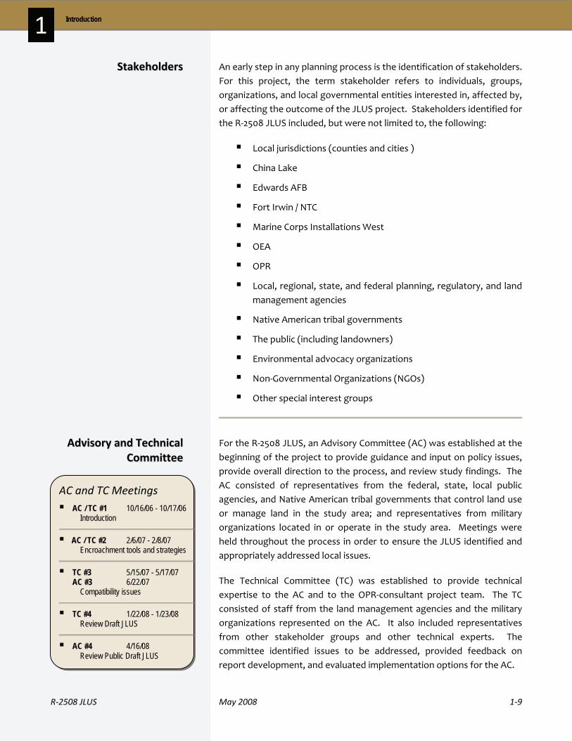
For the R‐2508 JLUS, an Advisory Committee (AC) was established at the beginning of the project to provide guidance and input on policy issues, provide overall direction to the process, and review study findings. The AC consisted of representatives from the federal, state, local public agencies, and Native American tribal governments that control land use or manage land in the study area; and representatives from military organizations located in or operate in the study area. Meetings were held throughout the process in order to ensure the JLUS identified and appropriately addressed local issues.
The Technical Committee (TC) was established to provide technical expertise to the AC and to the OPR‐consultant project team. The TC consisted of staff from the land management agencies and the military organizations represented on the AC. It also included representatives from other stakeholder groups and other technical experts. The committee identified issues to be addressed, provided feedback on report development, and evaluated implementation options for the AC.
AAddvviissoorryy aanndd TTeecchhnniiccaall CCoommmmiitttteeee
SSttaakkeehhoollddeerrss
AC and TC Meetings AC / TC #1 10/16/06 - 10/17/06
Introduction
AC / TC #2 2/6/07 - 2/8/07 Encroachment tools and strategies
TC #3 5/15/07 - 5/17/07 AC #3 6/22/07 Compatibility issues
TC #4 1/22/08 - 1/23/08 Review Draft JLUS
AC #4 4/16/08 Review Public Draft JLUS
1‐10 May 2008 R‐2508 JLUS
1 Introduction
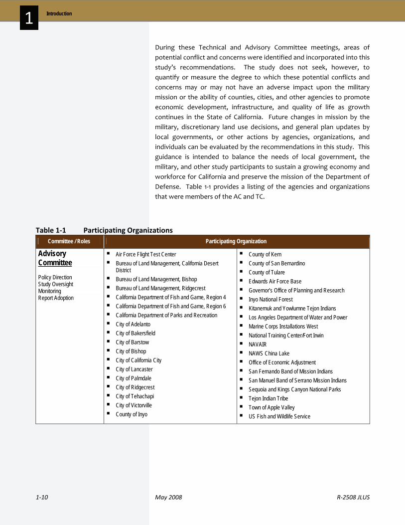
During these Technical and Advisory Committee meetings, areas of potential conflict and concerns were identified and incorporated into this study’s recommendations. The study does not seek, however, to quantify or measure the degree to which these potential conflicts and concerns may or may not have an adverse impact upon the military mission or the ability of counties, cities, and other agencies to promote economic development, infrastructure, and quality of life as growth continues in the State of California. Future changes in mission by the military, discretionary land use decisions, and general plan updates by local governments, or other actions by agencies, organizations, and individuals can be evaluated by the recommendations in this study. This guidance is intended to balance the needs of local government, the military, and other study participants to sustain a growing economy and workforce for California and preserve the mission of the Department of Defense. Table 1‐1 provides a listing of the agencies and organizations that were members of the AC and TC.
Table 1‐1 Participating Organizations Committee / Roles Participating Organization
Advisory Committee Policy Direction Study Oversight Monitoring Report Adoption
Air Force Flight Test Center Bureau of Land Management, California Desert
District Bureau of Land Management, Bishop Bureau of Land Management, Ridgecrest California Department of Fish and Game, Region 4 California Department of Fish and Game, Region 6 California Department of Parks and Recreation City of Adelanto City of Bakersfield City of Barstow City of Bishop City of California City City of Lancaster City of Palmdale City of Ridgecrest City of Tehachapi City of Victorville County of Inyo
County of Kern County of San Bernardino County of Tulare Edwards Air Force Base Governor’s Office of Planning and Research Inyo National Forest Kitanemuk and Yowlumne Tejon Indians Los Angeles Department of Water and Power Marine Corps Installations West National Training Center/Fort Irwin NAVAIR NAWS China Lake Office of Economic Adjustment San Fernando Band of Mission Indians San Manuel Band of Serrano Mission Indians Sequoia and Kings Canyon National Parks Tejon Indian Tribe Town of Apple Valley US Fish and Wildlife Service
R‐2508 JLUS May 2008 1‐11
1 Introduction
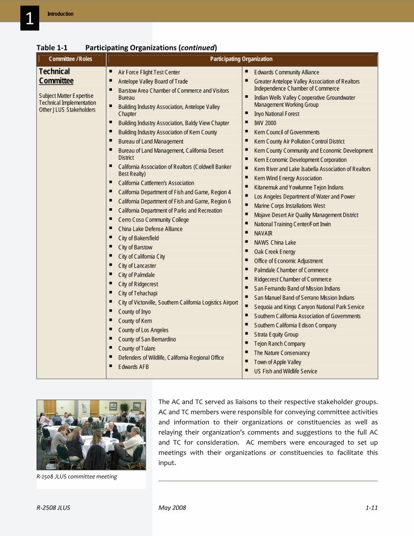
Table 1‐1 Participating Organizations (continued) Committee / Roles Participating Organization
Technical Committee Subject Matter Expertise Technical Implementation Other JLUS Stakeholders
Air Force Flight Test Center Antelope Valley Board of Trade Barstow Area Chamber of Commerce and Visitors
Bureau Building Industry Association, Antelope Valley
Chapter Building Industry Association, Baldy View Chapter Building Industry Association of Kern County Bureau of Land Management Bureau of Land Management, California Desert
District California Association of Realtors (Coldwell Banker
Best Realty) California Cattlemen's Association California Department of Fish and Game, Region 4 California Department of Fish and Game, Region 6 California Department of Parks and Recreation Cerro Coso Community College China Lake Defense Alliance City of Bakersfield City of Barstow City of California City City of Lancaster City of Palmdale City of Ridgecrest City of Tehachapi City of Victorville, Southern California Logistics Airport County of Inyo County of Kern County of Los Angeles County of San Bernardino County of Tulare Defenders of Wildlife, California Regional Office Edwards AFB
Edwards Community Alliance Greater Antelope Valley Association of Realtors
Independence Chamber of Commerce Indian Wells Valley Cooperative Groundwater
Management Working Group Inyo National Forest IWV 2000 Kern Council of Governments Kern County Air Pollution Control District Kern County Community and Economic Development Kern Economic Development Corporation Kern River and Lake Isabella Association of Realtors Kern Wind Energy Association Kitanemuk and Yowlumne Tejon Indians Los Angeles Department of Water and Power Marine Corps Installations West Mojave Desert Air Quality Management District National Training Center/Fort Irwin NAVAIR NAWS China Lake Oak Creek Energy Office of Economic Adjustment Palmdale Chamber of Commerce Ridgecrest Chamber of Commerce San Fernando Band of Mission Indians San Manuel Band of Serrano Mission Indians Sequoia and Kings Canyon National Park Service Southern California Association of Governments Southern California Edison Company Strata Equity Group Tejon Ranch Company The Nature Conservancy Town of Apple Valley US Fish and Wildlife Service
The AC and TC served as liaisons to their respective stakeholder groups. AC and TC members were responsible for conveying committee activities and information to their organizations or constituencies as well as relaying their organization’s comments and suggestions to the full AC and TC for consideration. AC members were encouraged to set up meetings with their organizations or constituencies to facilitate this input.
R‐2508 JLUS committee meeting

1‐12 May 2008 R‐2508 JLUS
1 Introduction
Public input was a critical component in the development of the R‐2508 JLUS. Public forums provided an opportunity for information exchange with the public at large and were useful in identifying the issues to be addressed in the R‐2508 JLUS.
Public Forum #1 October 2006 This public forum provided participants with an overview of the JLUS project and obtained input on the issues and opportunities that needed to be addressed in the JLUS.
Public Forum #2 April 2008 This forum, held during the 30‐day public review period, presented the draft R‐2508 JLUS, discussed the proposed findings and actions, and accepted public comments on the draft study.
At the beginning of the JLUS program, a Fact Sheet was developed to describe the JLUS program and objectives, identify methods to provide input into the process, and identify the study area proposed for the R‐2508 JLUS. This Fact Sheet was provided at all meetings and to all interested members of the public. A copy of the Fact Sheet is provided in Appendix A.
To assist the public in the review of the draft JLUS, the Executive Summary was widely distributed before and during the public forums
that presented the draft JLUS.
A project website was maintained to provide stakeholders, the public, and media representatives with access to project information. This website was maintained for the entire project to ensure that information was easily accessible. Information contained on the website included: project points of contact, schedules, reference documents, maps, public meeting information, and downloadable comment forms.
www.caj lus.com
PPuubblliicc FFoorruummss
PPuubblliicc OOuuttrreeaacchh MMaatteerriiaallss
R‐2508 JLUS May 2008 1‐13
1 Introduction
1 . 5 J L U S I m p l e m e n t a t i o n
It is important to note that once the JLUS process is completed, the final JLUS is not an adopted plan, but rather, a recommended set of compatibility guidelines that can be implemented by local jurisdictions, Native American tribal governments, agencies, and organizations. While the strategies in the final JLUS are not mandatory obligations, the involvement of stakeholders on the AC and TC has provided a set of strategies designed to meet local needs.
Following completion of the final JLUS, local jurisdictions, agencies, and organizations can work towards implementation of the strategies contained in Section 4 that apply to them. For instance, local jurisdictions can use the strategies in the R‐2508 JLUS to guide future appropriate general plan and zoning updates. Edwards AFB, China Lake, and Fort Irwin / NTC can use the JLUS to guide their efforts in compatibility planning. It is through the future actions of the stakeholders involved that the JLUS strategies will become a reality.
Key to implementation of strategies presented in this JLUS is the establishment of the JLUS Coordinating Committee (Strategy 9, Section 4). Through this committee, local jurisdictions, the military, and other interested parties will be able to work together to establish procedures, recommend specific actions for member agencies and make adjustments to strategies over time to ensure the JLUS remains relevant to the planning issues of the area. The JLUS also allows and promotes an adaptive response to issues, and allows local jurisdictions, agencies, Native American tribal governments, and other stakeholders to implement the JLUS strategies in a manner that best meets their needs. Through these efforts, the JLUS will remain a living document that begins an on‐going program of compatibility planning.
1 . 6 J L U S O r g a n i z a t i o n
The following is a brief overview of the organization of the R‐2508 JLUS, including the contents of each section and the materials included in the appendices.
Section 1, Introduction. Section 1 provides an introduction and context for the R‐2508 JLUS. This section describes the goals and objectives used to guide development of the JLUS, who was involved in developing the JLUS, public outreach methods, and the organization of the study.
1‐14 May 2008 R‐2508 JLUS
1 Introduction
Section 2, Study Area Profile. In developing a JLUS, a good understanding of the installations, military training areas, and local jurisdictions within the study area is necessary. For the R‐2508 JLUS, this section provides: an overview of the R‐2508 Complex’s history, descriptions of the primary installations that use the R‐2508 Complex, a look at the current missions and military units located at those installations, the economic impact of the installations on the region, and a discussion of future missions. This is followed by an overview of the region’s growth potential and a profile of each of the counties and cities within the study area, including population, housing, and employment statistics.
Section 3, Existing Plans, Studies and Programs. This section provides an overview of currently available and relevant plans, programs, and studies, which are tools to address compatibility issues in the study area. This includes technical studies, as well as local general plans and zoning ordinances.
Section 4, Recommendations. The final section of the JLUS provides a tool box of strategies that manage compatible development. The recommended strategies have been developed cooperatively with representatives from local jurisdictions, participating military installations, Native American tribal governments, state and federal agencies, local organizations, and interested individuals and landowners. As a result of a collaborative planning process, the recommendations in this section represent a true consensus plan: a realistic, coordinated approach to compatibility planning developed with the support of the stakeholders involved.
Section 5, Acronyms. A listing, with definitions, of the acronyms used in the JLUS.
Appendices. The main JLUS is supported by the following appendices.
A. R‐2508 JLUS Fact Sheet B. Kern County Height Restriction Zoning Ordinance
C. Compatibility Issues
D. Study Area Communities

Section 2
Study Area Profile

22 STUDY AREA PROF I L E
R‐2508 JLUS May 2008 2‐1
This chapter provides important information about the communities and military organizations within the R‐2508 Joint Land Use Study (JLUS) study area. The following section presents an overview of the history and current operations of the R‐2508 Complex and the three military installations within the study area: Naval Air Weapons Station (NAWS) China Lake; Edwards Air Force Base (AFB); and the National Training Center (NTC) at Fort Irwin. This section also provides profiles and analyses of development trends and growth potential in the local jurisdictions within the R‐2508 JLUS study area.
2 . 1 M i l i t a r y I n s t a l l a t i o n s a n d R a n g e s
Overview
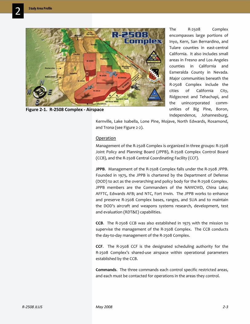
The R‐2508 Complex provides the largest single area of Special Use Airspace (SUA) over land in the United States, covering a land area of 20,000 square miles. The complex consists of restricted areas (R‐2508, R‐2502N, R‐2502E, R‐2505, R‐2506, R‐2515, and R‐2524), 10 Military Operations Areas (MOA), Air Traffic Control Assigned Airspace (ATCAA) areas, Controlled Firing Areas (CFAs), and other special airspace, such as: the CORDS Road, the Precision Impact Range Area, the Black Mountain Supersonic Corridor, the North Hypersonic Corridor, the South Hypersonic Corridor and the Airfield Approach and Departure Corridors (see Figure 2‐1).
RR‐‐22550088 CCoommpplleexx
In this section… Page 2.1 Military Installations and
Ranges
2.2 Military Socioeconomic Impacts
2.3 Land Management
2.4 Study Area Profile and Growth Trends
2.5 County and City Profiles
2-1
2-16
2-23
2-25
2-38

2‐2 May 2008 R‐2508 JLUS
2 Study Area Profile
Airspace Overview
Designated areas of airspace over both land and seaare necessary for military testing and training.Airspace corridors are also needed to provide airspaceconnectivity to and from military installations, andtraining and operating areas.
The Interagency Airspace Coordination Guide(http://www.fs.fed.us/r6/fire/aviation/airspace/web/guide/) provides a wealth of information on thedefinition and use of airspace. The following terms areused in the JLUS:
Military Operations Area (MOA). A MOA is airspaceestablished to segregate certain non‐hazardous flight activities from Instrument Flight Rules (IFR) traffic andto identify Visual Flight Rules (VFR) traffic. Withinthese areas, the military conducts flight activities, suchas acrobatic or abrupt flight maneuvers, intercepts, aircombat maneuvering missions, and aerial refueling. Inaddition to maintaining military readiness in the air,these areas are used to train student pilots. MOAs arethree dimensional areas. In addition to the mappedboundaries, MOAs have a defined floor (minimumaltitude) and ceiling (maximum altitude). Thesealtitudes can range from the surface up to themaximum ceiling of 17,999 feet above mean sea level(MSL). On sectional charts, IFR enroute charts, andterminal area charts, MOAs are identified in magentalettering that states a specific name followed by theletters “MOA”.
Military Training Routes (MTRs). MTRs are similar tocomplex systems of interrelated and interdependenthighways in the sky that connect military installations,ranges, and operation areas. They are used by theDOD to conduct low‐altitude navigation and tacticaltraining at airspeeds in excess of 250 knots and ataltitudes as low as just above surface level. These low‐level, high‐speed routes allow pilots to develop theskills necessary to avoid detection by enemy radar. InCalifornia Law (AB 1108, Pavley, Chapter 638, Statutesof 2002), a low‐altitude MTR is defined as a routewhere aircraft operate below 1,500 feet MSL.
Restricted Areas (RAs). RAs are an important asset to the DOD because they allow for the use of weapons for training and testing purposes. These areas are necessary for ground weapons and artillery firing, aerial gunnery, live and inert practice bomb drops, and guided missile testing. RAs provide locations for training and testing to support combat readiness of aviation and ground combat units while separating these activities from the public and general aviation users. These areas are identified by the letter “R” followed by a number on sectional charts, IFR enroute charts, and terminal area charts. The floor and ceiling altitudes, operating hours, and controlling agency can be found in the sectional chart legend.
Air Traffic Control Assigned Airspace (ATCAAs). The ATCAAs are used to fill the airspace gap between the top of the MOAs (FL180) and the base of R‐2508 (FL200 or 20,000 feet). When R‐2508 is not activated for military use, the ATCAAs may extend upward to FL600 (60,000 feet). ATCAAs are also located above the peripheral MOAs, outside the lateral boundaries of R‐2508, to provide additional work areas up to FL600 for segregation of military operations from IFR traffic (comprised of commercial and general aviation users). Figure 2‐3 shows the flight level restrictions for the R‐2508 Complex.
Controlled Firing Areas (CFAs). Controlled firing areas contain civilian and military activities which could be hazardous to “non‐participating” aircraft. They differ from MOAs and RAs in that radar or a ground lookout is utilized to indicate when an aircraft might be approaching the area. All activities are then suspended. The FAA does not chart CFAs because a CFA does not require a non‐participating aircraft to change its flight path.
R‐2508 JLUS May 2008 2‐3
2 Study Area Profile
The R‐2508 Complex encompasses large portions of Inyo, Kern, San Bernardino, and Tulare counties in east‐central California. It also includes small areas in Fresno and Los Angeles counties in California and Esmeralda County in Nevada. Major communities beneath the R‐2508 Complex include the cities of California City, Ridgecrest and Tehachapi, and the unincorporated comm‐unities of Big Pine, Boron, Independence, Johannesburg,
Kernville, Lake Isabella, Lone Pine, Mojave, North Edwards, Rosamond, and Trona (see Figure 2‐2).
Operation
Management of the R‐2508 Complex is organized in three groups: R‐2508 Joint Policy and Planning Board (JPPB), R‐2508 Complex Control Board (CCB), and the R‐2508 Central Coordinating Facility (CCF).
JPPB. Management of the R‐2508 Complex falls under the R‐2508 JPPB. Founded in 1975, the JPPB is chartered by the Department of Defense (DOD) to act as the overarching and policy body for the R‐2508 Complex. JPPB members are the Commanders of the NAWCWD, China Lake; AFFTC, Edwards AFB; and NTC, Fort Irwin. The JPPB works to enhance and preserve R‐2508 Complex bases, ranges, and SUA and to maintain the DOD’s aircraft and weapons systems research, development, test and evaluation (RDT&E) capabilities.
CCB. The R‐2508 CCB was also established in 1975 with the mission to supervise the management of the R‐2508 Complex. The CCB conducts the day‐to‐day management of the R‐2508 Complex.
CCF. The R‐2508 CCF is the designated scheduling authority for the R‐2508 Complex’s shared‐use airspace within operational parameters established by the CCB.
Commands. The three commands each control specific restricted areas, and each must be contacted for operations in the areas they control.
Figure 2‐1. R‐2508 Complex ‐ Airspace

2‐4 May 2008 R‐2508 JLUS
2 Study Area Profile

R‐2508 JLUS May 2008 2‐5
2 Study Area Profile
Current Operations
The R‐2508 Complex is composed of internal restricted areas, MOAs, ATCAAs, and other special airspace. Uses of the airspace and underlying lands include bombing ranges, supersonic corridors, low altitude high speed maneuvers, radar intercept areas, and refueling training areas. The JPPB has designated core hours of operation for the R‐2508 Complex. Operations may be conducted beyond these core hours but they are scheduled in advance. These are 6:30 AM to 10:30 PM (0630 – 2230) Monday thru Friday, and 8:00 AM to 4:00 PM (0800 –1600) on Saturday and Sunday.
The primary work areas for the military are the Isabella, Owens, Panamint, and Saline MOAs (see Figure 2‐3). These MOAs have a minimum altitude of 200 feet above ground level (AGL), with exceptions for areas near communities, airports, and wilderness areas. For instance, MOAs do not include airspace below 1,500 feet AGL within 3 miles of any charted airport. For areas located over Sequoia/Kings Canyon National Parks, John Muir and Domeland Wilderness Areas, and Death Valley National Park, the lower limit of the MOA is typically 3,000 feet AGL (although some exceptions were granted for areas outside of the National Monument and Wilderness Area at the time Death Valley National Park was designated). The upper bounds of the MOAs are at flight level 180 (FL180), which is a barometric altimeter reading of 18,000 feet.
Supersonic Flight
Supersonic flight is authorized in the high‐altitude Black Mountain Supersonic Corridors when scheduled. Supersonic flight is not normally authorized in R‐2508, MOAs, or ATCAAs unless approved by the CCB in advance. Supersonic operations may be conducted in other internal restricted areas after receiving specific approval from the appropriate scheduling agency.
Flight levels are expressed in three digits that represent hundreds of feet. For example, flight level 180 (written as FL180) represents a barometric altimeter indication of 18,000 feet.

2‐6 May 2008 R‐2508 JLUS
2 Study Area Profile
AGL = Above Ground Level SFC = Surface UNLTD = Unlimited Figure 2‐3. R‐2508 Complex Airspace Parameters

R‐2508 JLUS May 2008 2‐7
2 Study Area Profile
China Lake is located on 1.1 million acres of land in California’s upper Mojave Desert, and accounts for approximately one‐third of the Navy’s total land holdings. The land, ranging in altitude from 2,100 to 8,900 feet, varies from flat dry lakebeds to rugged piñon pine covered mountains. The majority of land is undeveloped and provides habitat for more than 340 species of wildlife and 650 plant types. The installation also has a rich cultural heritage, represented by Native American sites to locations and structures used by early miners and settlers.
The installation is divided into two major land areas: the North Range, encompassing 606,926 acres, and the South Range, encompassing 503,510 acres. The North Range lies in portions of Inyo, Kern, and San Bernardino counties, while the South Range is located entirely within San Bernardino County. The eastern perimeter of the South Range borders the Fort Irwin / NTC and the National Aeronautics and Space Administration (NASA) Goldstone Facility. The northeast corner abuts Death Valley National Park. The Bureau of Land Management (BLM) manages most of the lands adjacent to the west half of the South Range and most of the areas around the North Range. Figure 2‐2 displays China Lake’s two ranges in relation to the R‐2508 Complex and other adjacent military installations.
China Lake’s ranges provide a safe, secure, and highly instrumented volume of land and airspace in which controlled tests and operationally realistic training are conducted.
History
The Naval Ordnance Test Station (NOTS) China Lake was established in 1943 with the mission of supporting research, development, testing, and evaluation of weapons, as well as to provide primary training in the use of these weapons. NOTS China Lake and the Naval Ordnance Laboratory, Corona, California merged in 1967 to form the Naval Weapons Center (NWC), moving Corona‐based facilities and functions to China Lake by 1971. In January 1992, the Naval Weapons Center China Lake and the Pacific Missile Test Center Point Mugu were disestablished and combined as a single command, the Naval Air Warfare Center Weapons Division (NAWCWPNS). Since 2001, the Weapons Division is referred to as the Naval Air Systems Command (NAVAIR) Weapons Division. Currently, China Lake carries out the complete weapon‐development process.
NNAAWWSS CChhiinnaa LLaakkee
NAWS China Lake is comprised of 1.1 million acres of land.
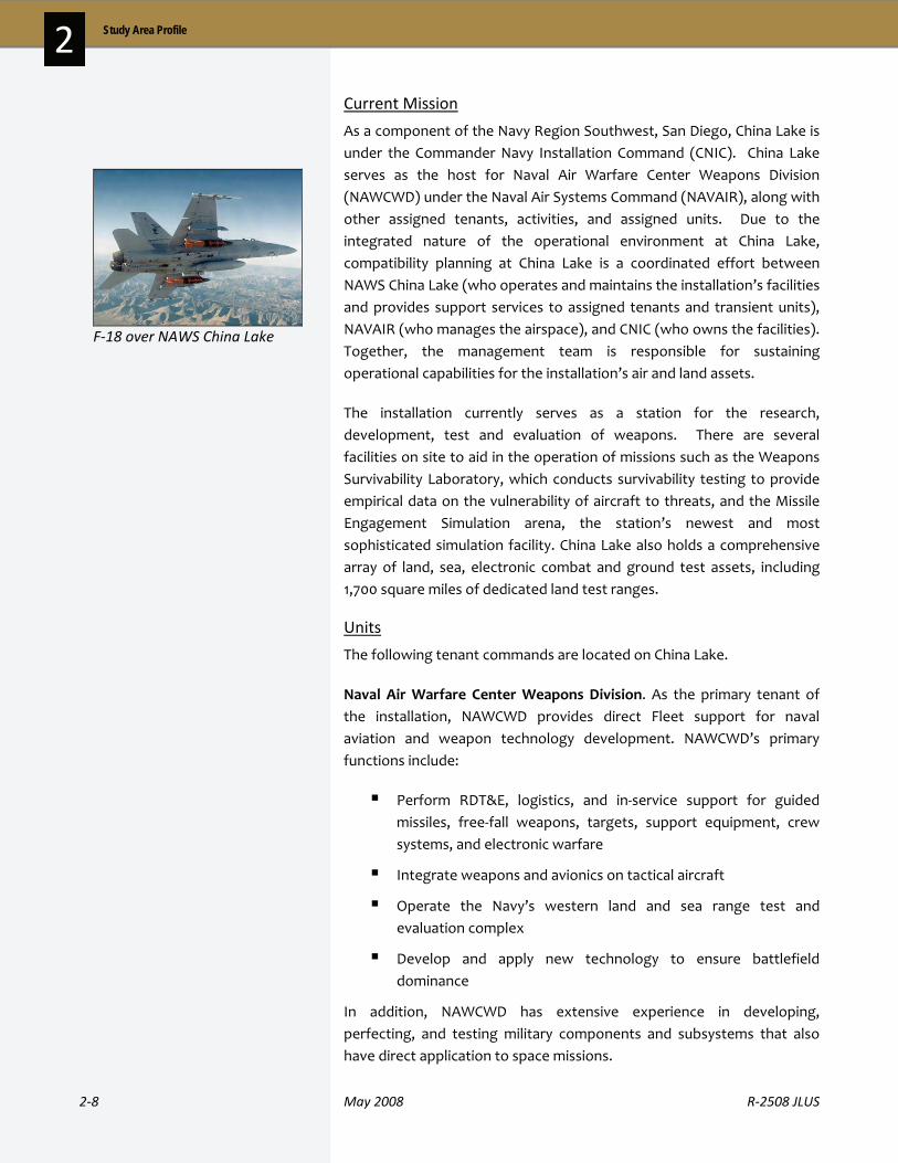
2‐8 May 2008 R‐2508 JLUS
2 Study Area Profile
Current Mission
As a component of the Navy Region Southwest, San Diego, China Lake is under the Commander Navy Installation Command (CNIC). China Lake serves as the host for Naval Air Warfare Center Weapons Division (NAWCWD) under the Naval Air Systems Command (NAVAIR), along with other assigned tenants, activities, and assigned units. Due to the integrated nature of the operational environment at China Lake, compatibility planning at China Lake is a coordinated effort between NAWS China Lake (who operates and maintains the installation’s facilities and provides support services to assigned tenants and transient units), NAVAIR (who manages the airspace), and CNIC (who owns the facilities). Together, the management team is responsible for sustaining operational capabilities for the installation’s air and land assets.
The installation currently serves as a station for the research, development, test and evaluation of weapons. There are several facilities on site to aid in the operation of missions such as the Weapons Survivability Laboratory, which conducts survivability testing to provide empirical data on the vulnerability of aircraft to threats, and the Missile Engagement Simulation arena, the station’s newest and most sophisticated simulation facility. China Lake also holds a comprehensive array of land, sea, electronic combat and ground test assets, including 1,700 square miles of dedicated land test ranges.
Units
The following tenant commands are located on China Lake.
Naval Air Warfare Center Weapons Division. As the primary tenant of the installation, NAWCWD provides direct Fleet support for naval aviation and weapon technology development. NAWCWD’s primary functions include:
Perform RDT&E, logistics, and in‐service support for guided missiles, free‐fall weapons, targets, support equipment, crew systems, and electronic warfare
Integrate weapons and avionics on tactical aircraft
Operate the Navy’s western land and sea range test and evaluation complex
Develop and apply new technology to ensure battlefield dominance
In addition, NAWCWD has extensive experience in developing, perfecting, and testing military components and subsystems that also have direct application to space missions.
F‐18 over NAWS China Lake
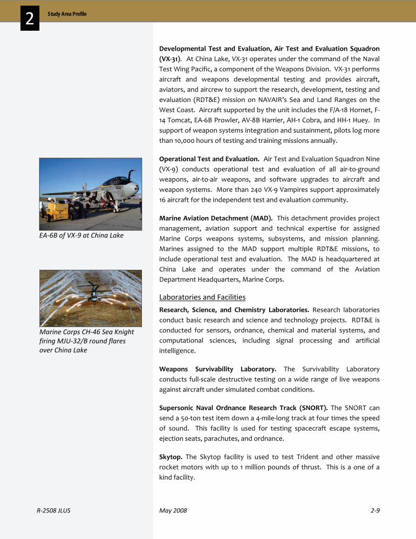
R‐2508 JLUS May 2008 2‐9
2 Study Area Profile
Developmental Test and Evaluation, Air Test and Evaluation Squadron (VX‐31). At China Lake, VX‐31 operates under the command of the Naval Test Wing Pacific, a component of the Weapons Division. VX‐31 performs aircraft and weapons developmental testing and provides aircraft, aviators, and aircrew to support the research, development, testing and evaluation (RDT&E) mission on NAVAIR’s Sea and Land Ranges on the West Coast. Aircraft supported by the unit includes the F/A‐18 Hornet, F‐14 Tomcat, EA‐6B Prowler, AV‐8B Harrier, AH‐1 Cobra, and HH‐1 Huey. In support of weapon systems integration and sustainment, pilots log more than 10,000 hours of testing and training missions annually.
Operational Test and Evaluation. Air Test and Evaluation Squadron Nine (VX‐9) conducts operational test and evaluation of all air‐to‐ground weapons, air‐to‐air weapons, and software upgrades to aircraft and weapon systems. More than 240 VX‐9 Vampires support approximately 16 aircraft for the independent test and evaluation community.
Marine Aviation Detachment (MAD). This detachment provides project management, aviation support and technical expertise for assigned Marine Corps weapons systems, subsystems, and mission planning. Marines assigned to the MAD support multiple RDT&E missions, to include operational test and evaluation. The MAD is headquartered at China Lake and operates under the command of the Aviation Department Headquarters, Marine Corps.
Laboratories and Facilities
Research, Science, and Chemistry Laboratories. Research laboratories conduct basic research and science and technology projects. RDT&E is conducted for sensors, ordnance, chemical and material systems, and computational sciences, including signal processing and artificial intelligence.
Weapons Survivability Laboratory. The Survivability Laboratory conducts full‐scale destructive testing on a wide range of live weapons against aircraft under simulated combat conditions.
Supersonic Naval Ordnance Research Track (SNORT). The SNORT can send a 50‐ton test item down a 4‐mile‐long track at four times the speed of sound. This facility is used for testing spacecraft escape systems, ejection seats, parachutes, and ordnance.
Skytop. The Skytop facility is used to test Trident and other massive rocket motors with up to 1 million pounds of thrust. This is a one of a kind facility.
EA‐6B of VX‐9 at China Lake
Marine Corps CH‐46 Sea Knight firing MJU‐32/B round flares over China Lake

2‐10 May 2008 R‐2508 JLUS
2 Study Area Profile
Energetics. The Energetics facilities provide full‐spectrum capabilities. Research and ingredient testing through full‐scale motor testing is conducted, and can detonate up to 500,000 pounds of explosives on the ranges.
Future Mission
The 2005 Base Realignment and Closure (BRAC) Commission recommended the realignment of China Lake to include:
Realignment and consolidation of facilities working in Weapons and Armaments Research, Development & Acquisition, and Test and Evaluation (RDAT&E) into a Naval Integrated RDAT&E
Movement of the gun and ammunition Research, Development, and Acquisition (RD&A) at China Lake to Picatinny Arsenal, New Jersey
Relocation of the fixed wing related Live Fire Test and Evaluation at Wright Patterson AFB, Ohio to China Lake
Realignment of Naval Air Warfare Center, Weapons Division, Point Mugu by relocating the Sensors, Electronic Warfare, and Electronics Research, Development, Acquisition, Test and Evaluation functions to China Lake
History
With a history going back to the 1930s, the area now known as Edwards AFB has been a focal point of aircraft and weapons development and testing for decades. After World War II, the United States Air Force (USAF) acquired over 301,000 acres from the Bureau of Land Management and private ownership in order to establish Edwards AFB. The United States Air Force Flight Test Center (AFFTC) was established at Edwards AFB in 1951.
The success of Edwards as a test facility can be attributed to good weather, isolated location, and two natural resources: the Rogers and Rosamond dry lake beds. The developed portion of the base and the installation’s paved runway are located adjacent to Rogers dry lakebed, the larger of the two lakebeds. With a 15,000‐foot paved runway and 9,000 foot overrun area, the main runway at Edwards AFB is one of the longest runways in the world, and an excellent asset for test and evaluation of new aircraft and systems. The base also has 18 other runways – two additional paved runways and 16 unpaved. The longest runway on the base is one of the lakebed runways, measuring 7.5 miles in length. The length and width of runways available provide the flexibility needed to safely recover test aircraft or aircraft returning with in‐flight emergencies.
Edwards AFB is comprised of 301,000 acres of land.
EEddwwaarrddss AAFFBB

R‐2508 JLUS May 2008 2‐11
2 Study Area Profile
Edwards AFB has been involved in the testing of every major weapons system in the Air Force arsenal. Among the notable tests conducted included Capt. Chuck Yeager breaking the sound barrier (1947), and the world’s fastest manned‐airplane flight (Mach 6.72). Aircraft testing today covers not only future systems, like the F/A‐22 Raptor and F‐35 Joint Strike Fighter, but also include on‐going test and evaluation work on current aircraft, including the B‐1, B‐2, B‐52, C‐5, C‐12, C‐17, C‐130, C‐130J, KC‐135, CV‐22, F‐16, F‐22, F‐117, F‐35, MQ‐1, MQ‐9, YAL‐1, and RQ‐4.
Current Mission
Edwards AFB supports the mission of the Air Force to guard the United States in its global interests through the use of superior defense systems in air, space and cyberspace. The AFFTC currently operates as the integral unit for the testing and evaluation of such systems. The AFFTC is able to do so within the confines of Edwards’ 301,000 acres of land and airspace within the R‐2508 complex, including three supersonic corridors and four aircraft spin areas.
The base currently has a vast collection of aircraft, each tested and evaluated for everything from airframe structures and propulsion to avionics and electronic warfare, in order to meet requirements for the combat missions in which they are intended to perform.
Air Force Flight Test Center
The mission of the AFFTC is to conduct and support research, development, test, and evaluation of aerospace systems from concept to combat. Current programs at the Test Center include the F/A‐22 Raptor, part of the Global Task Force designed to project air dominance quickly; the F‐35 Joint Strike Fighter, a high visibility test program that will be the most involved study ever conducted at Edwards; and the RQ‐4A Global Hawk Unmanned Combat Aerial System, providing near‐real‐time, high‐resolution intelligence, surveillance, and reconnaissance imagery to Air Force and joint battlefield commanders.
Units
Edwards AFB hosts more than 20 tenant organizations to include NASA Dryden Flight Research Center, United States Marine Corps Reserve Units, Air Force Research Laboratory’s Propulsion Directorate and the Air Force Operational and Test Evaluation Center’s Detachment 5. Edwards AFB has two operational wings, the 95th Air Base Wing (95 ABW) which supports and oversees the base’s daily operations, and the 412th Test Wing which conducts test and evaluation missions.
F‐22 small diameter bombing test – Edwards AFB
RQ‐4 Global Hawk Unmanned Aerial Vehicle
2‐12 May 2008 R‐2508 JLUS
2 Study Area Profile
95th Air Base Wing
The 95 ABW oversees base day‐to‐day operations and provides support for over 10,000 military, federal civilian, and contract personnel assigned to a 470,000‐square mile installation
412th Test Wing
The 412th Test Wing plans, conducts, analyzes, and reports on all flight and ground testing of aircraft, weapons systems, software, and components, as well as modeling and simulation for the Air Force. Within the Wing are the Test Pilot School and the Engineering and Electronic Warfare Division. The Combined Test Forces (CTF) make up the Test Program within the 412th Test Wing and conduct the test and analysis phases of flight missions at the base. The flight squadrons make up the final critical component of the Wing. There are nine flight test squadrons, each with up to twenty aircraft.
Future Mission
The 2005 BRAC Commission suggested the realignment of Edwards AFB, with the goal to relocate base‐level Low Altitude Navigation and Targeting Infrared for Night (LANTIRN) from Edwards to Hill AFB in Utah. They also recommended that Eglin AFB, Florida transfer their Air and Space Sensors, Electronic Warfare & Electronics and Information Systems Test and Evaluation to Edwards AFB.
The overall mission at Edwards will remain the same, but the aircraft and systems being tested and the tests being performed will continue to evolve in response to the needs of the Air Force, other DOD Services, and other agencies and countries with testing programs that need the space, expertise, and facilities offered by Edwards AFB and the AFFTC.
History
In 1940 President Roosevelt established the Mojave Anti‐Aircraft Range—a military reservation of 1,000 square miles in the area of present day Fort Irwin. In 1942 the post was renamed Camp Irwin in honor of Major General G. Leroy Irwin, a World War I commander of the 57th Field Artillery Brigade. The post was deactivated in 1944 and reactivated in 1951 as a training center for combat units during the Korean War.
The Army designated Fort Irwin as a permanent Class I installation in August 1961. During the Vietnam buildup, many units, primarily artillery and engineering, were trained and deployed to Southeast Asia directly from the post. In January of 1971, the Army again deactivated the post
Fort Irwin / National Training Center
Upon completion of their land expansion by fiscal year 2009, NTC Fort Irwin will be comprised of 764,788 acres of land.

R‐2508 JLUS May 2008 2‐13
2 Study Area Profile
and placed it in maintenance status under the control of Fort McArthur, California. Despite deactivation, the post continued to serve as a training site for National Guard and Army Reserve units.
In the late 1970s, during the post‐Vietnam forces drawdown, the Army pioneered a training concept designed to teach and sharpen the skills of its units, leaders, and soldiers. The concept was taken from proven Navy and Air Force programs (Top Gun and Red Flag, respectively), which honed the combat skills of pilots and aircrews and prepared them for the “first ten missions of the next war.” The ambitious Army training concept was to take Army units up to brigade size (approximately 5,000 soldiers), and put them into a training environment with simulated rigorous combat conditions using weapons simulators and actual live‐fire, against a creditable enemy, with expert trainers to help improve their combat skills and field performance. The stress and demanding conditions of this environment would sharpen the skills of soldiers and leaders, demonstrating how they must fight to win in actual combat.
In 1979, Fort Irwin, California was selected from among 11 other locations to become the NTC. Structured to conduct training to defeat Cold War threats, the first training exercise (known as a rotation) occurred with a battalion‐sized force (about 800 soldiers) in 1982, and progressively grew to brigade‐sized units by 1986. The proof‐of‐principle for the NTC training concept came during the 1991 Gulf War, when the Army and its joint partners took only 100 hours to defeat the Iraqi Army in ground combat in the Persian Gulf.
As we move forward into the 21st Century, NTC will continue to evolve and adapt to adversarial changes in tactics, techniques and procedures and will maintain the capability to rapidly adjust to emerging threats. However, there is one constant that will never change ‐‐ NTC is here to provide commanders the tools necessary to train the force, develop soldiers and leaders with warfighting skills and the warrior ethos required to fight and win our nation’s wars.
Current Mission
The NTC provides tough, realistic, joint and combined arms training in interagency, intergovernmental and multinational venues across the full spectrum of conflict to prepare brigade combat teams for combat. The NTC also trains, sustains, and deploys combat ready units from the 11th Armored Cavalry Regiment (ACR) and NTC Support Brigade for rotational support and worldwide contingency missions while taking care of soldiers, civilians, and family members.
Fort Irwin/NTC entrance sign
Simulated Iraqi environment for infantry training at the NTC
2‐14 May 2008 R‐2508 JLUS
2 Study Area Profile
Units
Fort Irwin’s primary function is to support the NTC. Units at Fort Irwin focused on supporting the installation, installation functions, or the training of rotating units. Units at Fort Irwin also have a secondary mission to be ready to deploy for worldwide contingency missions. The major units at Fort Irwin are described below.
United States Army Garrison
Fort Irwin falls under the United States Army Installation Management Command (IMCOM) Southwest Region. The United States Army Garrison at Fort Irwin provides installation services and support that enables soldier and family readiness and provides a high quality of life.
11th Armored Cavalry Regiment
The 11th ACR is permanently stationed at Fort Irwin with the primary mission of serving as the parent organization for the NTC's Opposing Force (OPFOR). The 11th ACR provides a professional "enemy" against which visiting Regular Army, Reserves, and National Guard task forces do battle when they come to the NTC to train.
Operations Group
The Operations Group trains Army combat units using realistic scenarios and provides meaningful feedback to soldiers, leaders, and staffs. Observer/Controller teams are paired with various elements of a training unit throughout the unit’s rotation to assess and critique performance and assist the unit in improving performance.
NTC Support Brigade
The NTC Support Brigade supports NTC tenant and rotational units as well as other government and civil agencies by providing quality Combat Service Support using units assigned to the NTC; provides personnel for operational support of the activities of Fort Irwin; and supervises activities and requirements not within the purview of the installation staff directorates.
Future Mission
Prior to land expansion initiatives in 1993, the NTC was comprised of 612,964 acres, of which 358,701 acres were available for maneuver training. According to a Land Use Requirement Study, about 193,300 additional acres were necessary for training purposes. The Department of the Army sought to acquire about 133,000 additional acres in October 2000, and later that year, with congressional approval, President Clinton signed the authorizing legislation. A Record of Decision was released for an expansion plan which would extend the existing central training
R‐2508 JLUS May 2008 2‐15
2 Study Area Profile
corridor and provide and extend a southern training corridor. The plan included utilizing 23,220 acres in the UTM 90 area of Fort Irwin that was not previously used for training, acquiring 48,760 acres located in the Avawatz Mountain area, and acquiring 78,530 acres in the Superior Valley area. Upon completion of the expansion plan in FY09, Fort Irwin will encompass 764,788 acres. NTC will be able to utilize about 77% of those acres for maneuver training. Areas NTC is unable to use for training include the NASA Goldstone deep space and satellite tracking facility (33,229 acres), the Leach Lake bombing range (91,330 acres) because of the presence of unexploded ordnance, and environmentally protected areas and archaeological sites (16,716 acres).
The NTC future mission will continue to:
Provide tough, realistic, joint and combined arms training in multi‐national venues across the full spectrum of conflict
Focus on developing collective task proficiency at the brigade combat team and all echelons below
Assist commanders in developing trained, competent leaders and soldiers by presenting them with current problem sets from the Contemporary Operating Environment (COE)
Identify unit training deficiencies, provide feedback to improve the force, and prepare for success in the Global War on Terrorism and future joint battlefields
Advocate Army transformation by leading change in developing and integrating emerging organizations, equipment, technologies, and doctrine
Provide a data source for lessons learned to improve doctrine, organizations, training, material, leadership and education, personnel and facilities (DOTMLPF) in order to prepare for full spectrum operations
Embed the most recent tactics, techniques, and procedures (TTP) from current operations in theater to better prepare follow‐on units
Train, sustain, and deploy combat ready units from the 11th ACR and NTC Support Brigade for worldwide contingency and rotational support missions
Take care of soldiers, civilians, and family members

2‐16 May 2008 R‐2508 JLUS
2 Study Area Profile
2 . 2 M i l i t a r y S o c i o e c o n o m i c I m p a c t s
Military installations typically have a significant positive economic impact on adjacent communities. They add to the economic base of a region through direct expenditures (salaries to employees, purchases of services and supplies, contracts, etc.) and secondary effects (jobs and income created by increased activity in the economy from direct expenditures and suppliers to primary industries). For some areas, the local economy is driven by military expenditures, and fluctuations in spending can notably impact the local economy.
The following pages contain information on the economic impact each installation has on the surrounding region. Due to differences in data available, information on secondary effects will vary.
The military installations and the local communities are also linked through the services each provides. With many military personnel and their families living in nearby communities, local jurisdictions and agencies provide a range of services to these personnel, from public schools and libraries to police and fire protection. The installations also support local communities through the involvement of base personnel in local charities and other civic organizations and by responding with critical services when needed, such as fire response, explosive ordnance disposal, and other emergency services.
Demographics – China Lake
The Navy is the largest employer in the Indian Wells Valley, providing a significant economic thrust for the Valley and adding to the economic base of surrounding communities. China Lake provides direct employment for 767 military personnel and 3,388 civilians. Additionally, the installation provides employment for over 2,400 contract civilians, located both on the installation and off site (see Table 2‐1).
Table 2‐1. Population Breakdown, China Lake
Variable Total
Military Personnel 767
Civilians 3,388
Contract Civilians (On Site) 1,203
Contract Civilians (Off Site) 1,231
Source: John O’Gara, US Navy, data as of 30 September 2007
NNAAWWSS CChhiinnaa LLaakkee

R‐2508 JLUS May 2008 2‐17
2 Study Area Profile
Economic Impact – China Lake
Annual payroll for military and civilians at China Lake, as well as the installation’s expenditures in the area have significant impacts on the surrounding cities and region as a whole. The annual payroll in 2007 for personnel at China Lake was $432 million. Over 91 percent of the total payroll was to civilians. Annual contract expenditures totaled $531 million (Table 2‐2).
Table 2‐2. Economic Impact Details, China Lake
Variable Value
Annual Payroll $432,000,000
Military $37,000,000
Civilian $395,000,000
Annual Contract Expenditures $531,000,000
Annual Other Purchases $21,000,000
Source: John O’Gara, US Navy, data as of 30 September 2007
Data from the 2000 Census reflects the positive influence that China Lake has on the City of Ridgecrest. The data shows that a much higher percentage of employees in Ridgecrest (41 percent) are employed in higher paying management, professional, and related occupations than Kern County as a whole (27 percent). Following this trend, the median annual family income in Ridgecrest in 1999 was $52,725, compared to a Kern County median income of $39,403. More than 52 percent of Ridgecrest families had annual incomes of $50,000 or greater, compared to only 39 percent of families countywide.
Military personnel who live on‐station spend approximately 40 percent of their income in the local community. Those living off‐station have higher spending levels due to expenses such as rent, mortgage, and utility payments.
Housing – China Lake
The community area of China Lake was annexed by the City of Ridgecrest in 1982, and today, the two maintain an interdependent, supportive relationship. Most civilian and contract employees of China Lake reside in Ridgecrest.
NAWS China Lake bachelor’s enlisted quarters
2‐18 May 2008 R‐2508 JLUS
2 Study Area Profile
The majority of family housing on the installation is duplexes. There are 19 Senior Officer Quarters units, one Flag Officer unit, and 172 family units. All family units have three or more bedrooms and two full bathrooms.
Single enlisted members and married personnel not accompanied by their families are assigned Bachelor Enlisted Quarters (BEQ). There are 182 modular rooms in the three‐building BEQ complex.
To help China Lake employees acquire housing in the community, the NAWS China Lake Housing Office established the Housing Referral Service. This service maintains information about the local housing market and directs military members to available housing in Ridgecrest and the surrounding Indian Wells Valley.
Several recent projects for the station include a multimillion dollar renovation of family and bachelor housing under the “Navy Neighborhoods of Excellence” program.
The Antelope Valley has successfully blended the traditional pursuits of business, commerce, industry, agriculture, and mining with the technology of aerospace. The area is known for its contributions to the defense of the nation with its close proximity to existing DOD facilities, including Edwards AFB. The installation is the largest employer in the Antelope Valley.
The Antelope Valley area is comprised primarily of unincorporated lands that fall inside of Kern, Los Angeles, and San Bernardino counties. The nearby City of Palmdale enjoys a supportive relationship with the base. Aerospace is Palmdale’s largest industry and employer with thousands of residents working at Air Force Plant 42 Production Flight Test Installation and at other facilities on Edwards AFB. The cities of Lancaster and Palmdale are located just to the south of the base and serve as a home for many Edwards AFB civilian employees. According to the Lancaster’s General Plan 2030 Update, the installation is the number one employer for the city. The City of California City lies north of Edwards AFB, and the base is the major employer of residents in that city as well.
EEddwwaarrddss AAFFBB

R‐2508 JLUS May 2008 2‐19
2 Study Area Profile
Demographics – Edwards AFB
In Fiscal Year 2006 (FY06), the installation reported a total population (employment plus active duty dependents) of 15,739 people. Table 2‐3 provides a breakdown of the direct employment figures.
Table 2‐3. Population Breakdown, Edwards AFB
Variable Breakdown Total
Military Personnel 3,209
Active Duty 2,879
Air Force Reserve/National Guard 112
Other Military Personnel 218
Active Duty Military Dependents 4,628
Civilians 7,902
Appropriated Fund Civilians 3,963
Non-Appropriated Fund Civilians 264
Civilian BX 190
Contract Civilians 3,408
Private Businesses On Base 77
TOTAL BASE POPULATION 15,739
Source: AF Flight Test Center Economic Impact Analysis FY06
Economic Impact – Edwards AFB
The total economic impact of Edwards AFB on the surrounding region is measured in three categories: annual payroll, annual contract expenditures, and value of jobs created. Payroll expenditures are payment for direct employment at the installation, such as military and civilian employees. Contract expenditures include the value of local contracts let by the installation. The major component under contract expenditures was $163 million spent on service contracts. While the other two categories reflect direct expenses, the value of jobs created represents secondary impacts in the region; that is, given payroll and expenditures, the value of other jobs generated by this increase in the economy. For FY06, this was estimated at $575 million. The total economic impact of the installation for FY06 was just over $1.4 billion. Further details on economic impact are shown on Table 2‐4.
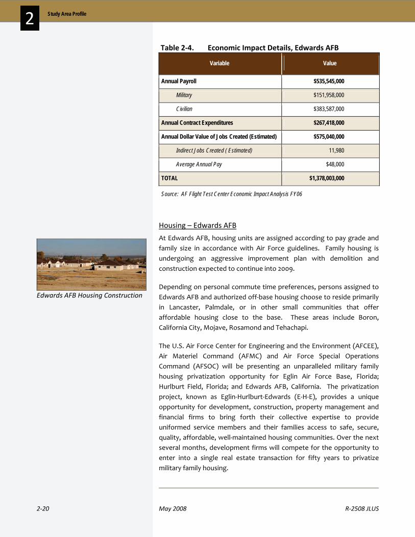
2‐20 May 2008 R‐2508 JLUS
2 Study Area Profile
Table 2‐4. Economic Impact Details, Edwards AFB
Variable Value
Annual Payroll $535,545,000
Military $151,958,000
Civilian $383,587,000
Annual Contract Expenditures $267,418,000
Annual Dollar Value of Jobs Created (Estimated) $575,040,000
Indirect Jobs Created ( Estimated) 11,980
Average Annual Pay $48,000
TOTAL $1,378,003,000
Source: AF Flight Test Center Economic Impact Analysis FY06
Housing – Edwards AFB
At Edwards AFB, housing units are assigned according to pay grade and family size in accordance with Air Force guidelines. Family housing is undergoing an aggressive improvement plan with demolition and construction expected to continue into 2009.
Depending on personal commute time preferences, persons assigned to Edwards AFB and authorized off‐base housing choose to reside primarily in Lancaster, Palmdale, or in other small communities that offer affordable housing close to the base. These areas include Boron, California City, Mojave, Rosamond and Tehachapi.
The U.S. Air Force Center for Engineering and the Environment (AFCEE), Air Materiel Command (AFMC) and Air Force Special Operations Command (AFSOC) will be presenting an unparalleled military family housing privatization opportunity for Eglin Air Force Base, Florida; Hurlburt Field, Florida; and Edwards AFB, California. The privatization project, known as Eglin‐Hurlburt‐Edwards (E‐H‐E), provides a unique opportunity for development, construction, property management and financial firms to bring forth their collective expertise to provide uniformed service members and their families access to safe, secure, quality, affordable, well‐maintained housing communities. Over the next several months, development firms will compete for the opportunity to enter into a single real estate transaction for fifty years to privatize military family housing.
Edwards AFB Housing Construction
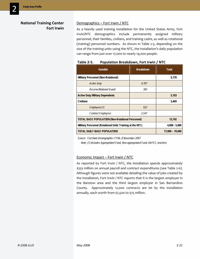
R‐2508 JLUS May 2008 2‐21
2 Study Area Profile
Demographics – Fort Irwin / NTC
As a heavily used training installation for the United States Army, Fort Irwin/NTC demographics include permanently assigned military personnel, their families, civilians, and training cadre, as well as rotational (training) personnel numbers. As shown in Table 2‐5, depending on the size of the training units using the NTC, the installation’s daily population can range from just over 17,000 to nearly 19,000 people.
Table 2‐5. Population Breakdown, Fort Irwin / NTC
Variable Breakdown Total
Military Personnel (Non-Rotational) 5,170
Active Duty 4,787
Reserve/National Guard 383
Active Duty Military Dependents 5,103
Civilians 3,469
Employees(1) 922
Contract Employees 2,547
TOTAL BASE POPULATION (Non-Rotational Personnel) 13,742
Military Personnel (Rotational Units Training at the NTC) 4,000 - 5,000
TOTAL DAILY BASE POPULATION 17,000 – 19,000
Source: Fort Irwin Demographics FY06, 8 November 2007 Note: (1) Includes Appropriated Fund, Non-appropriated Fund, AAFES, teachers
Economic Impact – Fort Irwin / NTC
As reported by Fort Irwin / NTC, the installation spends approximately $355 million on annual payroll and contract expenditures (see Table 2‐6). Although figures were not available detailing the value of jobs created by the installation, Fort Irwin / NTC reports that it is the largest employer in the Barstow area and the third largest employer in San Bernardino County. Approximately 12,000 contracts are let by the installation annually, each worth from $2,500 to $75 million.
National Training Center Fort Irwin

2‐22 May 2008 R‐2508 JLUS
2 Study Area Profile
Table 2‐6. Economic Impact Details, Fort Irwin / NTC
Variable Value
Annual Payroll $114,400,000
Military $86,800,000
Civilian $27,600,000
Annual Contract Expenditures $241,000,000
TOTAL $355,400,000
Source: Fort Irwin Demographics FY06, 8 November 2007
Housing – Fort Irwin / NTC
Fort Irwin Military Family Housing offers 2,046 homes, with 715 new homes to be built within the next eight years. The new construction will replace many of the installation’s older homes and reduce the waiting list for family housing.
California Military Communities LLC is working with the United States Army and Clark Pinnacle to privatize housing at Fort Irwin. Clark Pinnacle owns, operates, and develops the military housing needed. Over the next eight years, Clark Pinnacle will build 715 new houses and demolish 385 substandard homes in the Sandy Basin and Cactus Cove developments. The first new neighborhood is Crackerjack Flats, consisting of 241 Company Grade Officer housing units. The Irwin Town Center will be a mixed‐use urban village, featuring over 22,000 square feet of retail space. Two hundred new one‐bedroom apartments will be constructed in the Center for senior unaccompanied soldiers.
Sandy Basin community housing at Fort Irwin/NTC

R‐2508 JLUS May 2008 2‐23
2 Study Area Profile
2 . 3 L a n d M a n a g e m e n t
The total land area in the R‐2508 study area covers over 12 million acres of land. As Table 2‐7 and Figures 2‐4 and 2‐5 show, a significant amount of this land is managed by federal agencies, leaving relatively little land available for private development. The extreme example of this is the land in Inyo County. With a total land area of almost 6.5 million acres (including lands both inside and outside of the R‐2508 study area), over 98 percent of this land is managed by public agencies, and most is held by the federal government.
The extent of public managed lands has important implications for compatibility planning in the R‐2508 JLUS. Given the limited private land holdings in the region, extensive coordination and cooperation between the military, local jurisdictions, and other agencies with regulatory control over land use is needed to ensure cities and counties have adequate opportunities for economic expansion.
Table 2‐7. Land Management / Ownership in Study Area
Management / Ownership
Acres Percent
Military 2,111,072 17%
State Lands 92,788 1%
BLM 2,972,950 25%
National Forest 1,577,381 13%
National Parks 3,249,002 27%
Other (incl. Private) 2,106,274 17%
TOTAL 12,109,467 100%
Source: Matrix Design Group, 2007
17%
1%
25%
13%
27%
17%
Military (17%) State Lands (1%)BLM (25%) National Forest (13%)National Parks (27%) Other (incl. Private) (17%)
Figure 2‐4. Land Management within the Study Area
NOTE:
Due to different databases, the acreage on Tables 2‐7 and 2‐8 differ slightly (about 0.1%).

2‐24 May 2008 R‐2508 JLUS
2 Study Area Profile

R‐2508 JLUS May 2008 2‐25
2 Study Area Profile
2 . 4 S t u d y A r e a P r o f i l e a n d G r o w t h T r e n d s
The following section provides a breakdown of the study area by jurisdiction (land area) and a look at historic and projected population and housing data for the counties and cities within the Study Area. Common data sources that covered all of the jurisdictions involved were used in order to provide a comparative look at trends. When reviewing the county data provided, it is important to note that only a portion of each county is in the Study Area. Significant portions of the population and housing growth presented is occurring in the Los Angeles basin, Inland Empire, and southern San Joaquin Valley portions of the larger counties – areas that are outside of the Study Area. This data is provided as a context for the region and the potential for growth pressures that are moving further into the Upper Desert areas.
Table 2‐8 shows the land area (in acres) contained in each of the counties and cities within the study area. The acreages presented for the cities and counties reflect an overlap of areas. The county totals summarize all areas within the study area for that county, including the area within the incorporated city limits, areas within a city’s sphere of influence (SOI), and land areas used for the military and managed by federal agencies.
With 78 percent of its total land inside the study area, Inyo County accounts for 42 percent of the total study area and is home to the majority of the China Lake North Range (see Figures 2‐2 and 2‐6). The counties of Kern and San Bernardino each comprise over 20 percent of the study area. Forty‐seven percent of Kern County is inside the study area, and 23 percent of San Bernardino County. Only 2 percent of Los Angeles County’s total land area lies within the JLUS study area, which accounts for less than one percent of the total study area. Regardless of land area lying within the study area, each aforementioned county is integral to the R‐2508 JLUS, participating in the identification and suggestions for the amelioration of identified compatibility issues.
Table 2‐8. Land Area, by Jurisdiction, within the Study Area
Acres
Jurisdiction County City
Limits SOI
Fresno 161,248
Inyo County 5,096,627
Kern County 2,465,607
California City 130,016 130,016
Ridgecrest 13,691 23,102
Tehachapi 6,288 15,060
Los Angeles County
54,885
San Bernardino County
2,979,923
Tulare County 1,364,752
TOTAL 12,123,042 149,995 168,178
Source: Matrix Design Group, 2007
Study Area Overview
42.0%
0.5%20.3%
24.6%
1.3%
11.3%
Inyo (42.0%) Los Angeles (0.5%)Kern (20.3%) San Bernardino (24.6%)Fresno (1.3%) Tulare (11.3%)
Figure 2‐6. Land Area within the Study
Area
2‐26 May 2008 R‐2508 JLUS
2 Study Area Profile
The JLUS study area encompasses 20,000 square miles and includes sizeable areas within the counties of Inyo, Kern, Los Angeles, San Bernardino, and Tulare. A small portion of Fresno County is also located within the study area; however, this land is not considered significantly impacted by R‐2508 operations and is not evaluated further.
Only three cities are located inside the study area: California City, Ridgecrest, and Tehachapi. The study area also contains a number of unincorporated communities, including: Big Pine, Boron, Independence, Johannesburg, Kernville, Lake Isabella, Randsburg, Wofford Heights, South Lake, Mt. Mesa, Weldon, Onyx, Lone Pine, Mojave, North Edwards, Rosamond, and Trona. A number of other cities, while outside of the R‐2508 Complex, have an interest in R‐2508, including the cities of Adelanto, Bakersfield, Barstow, Bishop, Lancaster, Palmdale, and Victorville. A complete list of communities in the study area is contained in Appendix D.
California is unique in many ways. With a wide variety of climates and landscapes, diverse population demographics, prolific natural diversity, productive agricultural base, dense urban centers, and more military installations and operational areas than any other state in the nation, California is a magnet for growth.
According to the California Department of Finance, the State’s population grew from 29.8 million in 1990 to 37.7 million in 2007 (total growth of 27 percent or about 1.6 percent/year). By the year 2020, the State’s population is projected to reach 44.1 million and then continue to expand to almost 59.5 million by 2050. Between 2007 and 2050, the State’s population will expand by 58 percent. While much of the population growth previously centered in the State’s coastal urban areas, this growth has been expanding inward to include the Mojave Desert area of California.
County Population Growth Trends
Table 2‐9 provides an overview of the current population (January 2007) for the primary five counties in the study area and the 2050 population estimates prepared by the California Department of Finance. In addition to the population numbers, the table also shows the percent change in population and the percent of the region’s growth found in that county. This last factor is derived by taking the total population projected for 2050 for the five county regions and calculating the percent share each county’s growth will contribute to the overall regional growth.
Study Area Trends
Study Area Focus
This subsection provides a profile of the counties and cities within the study area and cities within the surrounding region in relation to population growth, housing growth, and housing median home values. Looking at cities outside of the study area helps provide the context for discussing growth trends in the region.
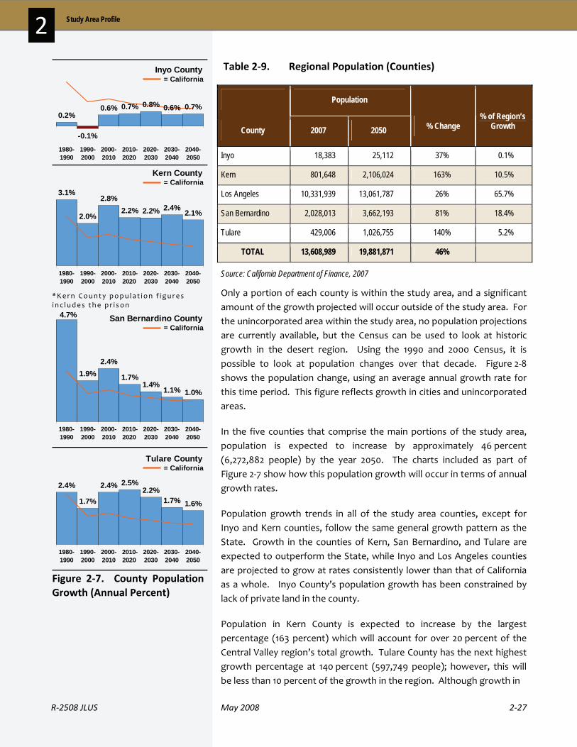
R‐2508 JLUS May 2008 2‐27
2 Study Area Profile
Table 2‐9. Regional Population (Counties)
Only a portion of each county is within the study area, and a significant amount of the growth projected will occur outside of the study area. For the unincorporated area within the study area, no population projections are currently available, but the Census can be used to look at historic growth in the desert region. Using the 1990 and 2000 Census, it is possible to look at population changes over that decade. Figure 2‐8 shows the population change, using an average annual growth rate for this time period. This figure reflects growth in cities and unincorporated areas.
In the five counties that comprise the main portions of the study area, population is expected to increase by approximately 46 percent (6,272,882 people) by the year 2050. The charts included as part of Figure 2‐7 show how this population growth will occur in terms of annual growth rates.
Population growth trends in all of the study area counties, except for Inyo and Kern counties, follow the same general growth pattern as the State. Growth in the counties of Kern, San Bernardino, and Tulare are expected to outperform the State, while Inyo and Los Angeles counties are projected to grow at rates consistently lower than that of California as a whole. Inyo County’s population growth has been constrained by lack of private land in the county.
Population in Kern County is expected to increase by the largest percentage (163 percent) which will account for over 20 percent of the Central Valley region’s total growth. Tulare County has the next highest growth percentage at 140 percent (597,749 people); however, this will be less than 10 percent of the growth in the region. Although growth in
Population
County 2007 2050 % Change % of Region’s
Growth
Inyo 18,383 25,112 37% 0.1%
Kern 801,648 2,106,024 163% 10.5%
Los Angeles 10,331,939 13,061,787 26% 65.7%
San Bernardino 2,028,013 3,662,193 81% 18.4%
Tulare 429,006 1,026,755 140% 5.2%
TOTAL 13,608,989 19,881,871 46%
Source: California Department of Finance, 2007
0.2%
-0.1%
0.6% 0.7% 0.8% 0.6% 0.7%
1980-1990
1990-2000
2000-2010
2010-2020
2020-2030
2030-2040
2040-2050
= CaliforniaInyo County
3.1%
2.0%
2.8%2.2% 2.2% 2.4% 2.1%
1980-1990
1990-2000
2000-2010
2010-2020
2020-2030
2030-2040
2040-2050
= CaliforniaKern County
*Kern County popu la t ion f i gu res i n c ludes the pr i son
1.9%2.4%
1.7%1.4%
1.1% 1.0%
1980-1990
1990-2000
2000-2010
2010-2020
2020-2030
2030-2040
2040-2050
= CaliforniaSan Bernardino County4.7%
2.4%
1.7%
2.4% 2.5%2.2%
1.7% 1.6%
1980-1990
1990-2000
2000-2010
2010-2020
2020-2030
2030-2040
2040-2050
= CaliforniaTulare County
Figure 2‐7. County Population Growth (Annual Percent)

2‐28 May 2008 R‐2508 JLUS
2 Study Area Profile
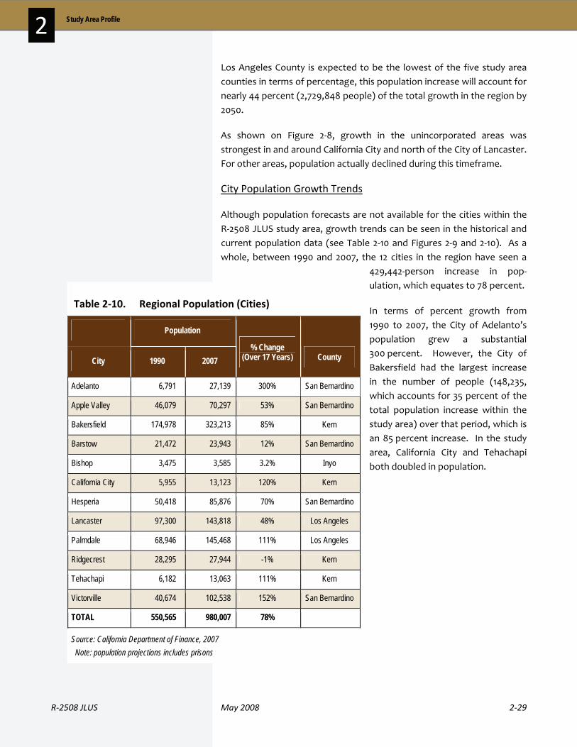
R‐2508 JLUS May 2008 2‐29
2 Study Area Profile
Los Angeles County is expected to be the lowest of the five study area counties in terms of percentage, this population increase will account for nearly 44 percent (2,729,848 people) of the total growth in the region by 2050.
As shown on Figure 2‐8, growth in the unincorporated areas was strongest in and around California City and north of the City of Lancaster. For other areas, population actually declined during this timeframe.
City Population Growth Trends
Although population forecasts are not available for the cities within the R‐2508 JLUS study area, growth trends can be seen in the historical and current population data (see Table 2‐10 and Figures 2‐9 and 2‐10). As a whole, between 1990 and 2007, the 12 cities in the region have seen a
429,442‐person increase in pop‐ulation, which equates to 78 percent.
In terms of percent growth from 1990 to 2007, the City of Adelanto’s population grew a substantial 300 percent. However, the City of Bakersfield had the largest increase in the number of people (148,235, which accounts for 35 percent of the total population increase within the study area) over that period, which is an 85 percent increase. In the study area, California City and Tehachapi both doubled in population.
Table 2‐10. Regional Population (Cities)
Population
City 1990 2007 % Change
(Over 17 Years) County
Adelanto 6,791 27,139 300% San Bernardino
Apple Valley 46,079 70,297 53% San Bernardino
Bakersfield 174,978 323,213 85% Kern
Barstow 21,472 23,943 12% San Bernardino
Bishop 3,475 3,585 3.2% Inyo
California City 5,955 13,123 120% Kern
Hesperia 50,418 85,876 70% San Bernardino
Lancaster 97,300 143,818 48% Los Angeles
Palmdale 68,946 145,468 111% Los Angeles
Ridgecrest 28,295 27,944 -1% Kern
Tehachapi 6,182 13,063 111% Kern
Victorville 40,674 102,538 152% San Bernardino
TOTAL 550,565 980,007 78%
Source: California Department of Finance, 2007 Note: population projections includes prisons
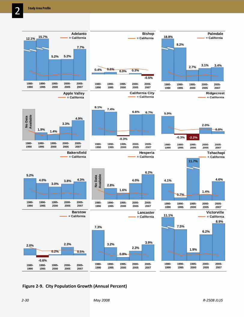
2‐30 May 2008 R‐2508 JLUS
2 Study Area Profile
5.2% 5.2%
7.7%
1980-1990
1990-1995
1995-2000
2000-2005
2005-2007
Adelanto= California12.1% 15.7%
1.9% 1.4%
3.3%4.9%
1980-1990
1990-1995
1995-2000
2000-2005
2005-2007
No
Dat
aA
vaila
ble
Apple Valley= California
5.2%4.0%
3.0%3.8% 4.3%
1980-1990
1990-1995
1995-2000
2000-2005
2005-2007
Bakersfield= California
2.0%
-0.6%
0.2%
2.3%
0.5%
1980-1990
1990-1995
1995-2000
2000-2005
2005-2007
Barstow= California
0.4% 0.6% 0.0% 0.3%
-0.5%
1980-1990
1990-1995
1995-2000
2000-2005
2005-2007
Bishop= California
8.1% 7.4%
-0.3%
6.6% 6.7%
1980-1990
1990-1995
1995-2000
2000-2005
2005-2007
California City= California
2.8%1.6%
4.0%
6.2%
1980-1990
1990-1995
1995-2000
2000-2005
2005-2007
Hesperia= California
No
Dat
aA
vaila
ble
7.3%
3.2%
0.8%
2.3%3.9%
1980-1990
1990-1995
1995-2000
2000-2005
2005-2007
Lancaster= California
8.2%
2.7% 3.1% 3.4%
1980-1990
1990-1995
1995-2000
2000-2005
2005-2007
Palmdale= California18.8%
5.9%
-0.3%
2.0%
-2.2%
0.8%
1980-1990
1990-1995
1995-2000
2000-2005
2005-2007
Ridgecrest= California
4.1%
0.7%1.4%
4.6%
1980-1990
1990-1995
1995-2000
2000-2005
2005-2007
Tehachapi= California
11.7%
7.5%
1.9%
6.2%
8.9%
1980-1990
1990-1995
1995-2000
2000-2005
2005-2007
Victorville = California11.1%
Figure 2‐9. City Population Growth (Annual Percent)

R‐2508 JLUS May 2008 2‐31
2 Study Area Profile
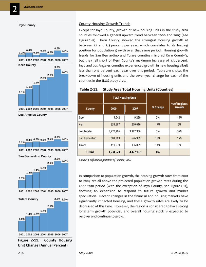
2‐32 May 2008 R‐2508 JLUS
2 Study Area Profile
County Housing Growth Trends
Except for Inyo County, growth of new housing units in the study area counties followed a general upward trend between 2000 and 2007 (see Figure 2‐11). Kern County showed the strongest housing growth at between 1.1 and 3.3 percent per year, which correlates to its leading position for population growth over that same period. Housing growth trends for San Bernardino and Tulare counties mirrored Kern County’s, but they fell short of Kern County’s maximum increase of 3.3 percent. Inyo and Los Angeles counties experienced growth in new housing albeit less than one percent each year over this period. Table 2‐11 shows the breakdown of housing units and the seven‐year change for each of the counties in the JLUS study area.
Table 2‐11. Study Area Total Housing Units (Counties)
In comparison to population growth, the housing growth rates from 2001 to 2007 are all above the projected population growth rates during the 2000‐2010 period (with the exception of Inyo County, see Figure 2‐11), showing an expansion to respond to future growth and market speculation. Recent changes in the financial and housing markets have significantly impacted housing, and these growth rates are likely to be depressed at this time. However, the region is considered to have strong long‐term growth potential, and overall housing stock is expected to recover and continue to grow.
Total Housing Units
County 2000 2007 % Change % of Region’s
Growth
Inyo 9,042 9,250 2% < 1%
Kern 231,567 270,616 17% 6%
Los Angeles 3,270,906 3,382,356 3% 76%
San Bernardino 601,369 676,909 13% 15%
Tulare 119,639 136,059 14% 3%
TOTAL 4,234,523 4,477,197 6%
Source: California Department of Finance, 2007
0.3%0.6%
0.2%0.2%0.4%
0.2%0.4%
2001 2002 2003 2004 2005 2006 2007
Inyo County
2.9%
3.3%
2.6%
1.1%
1.5%1.9%
2.3%
2001 2002 2003 2004 2005 2006 2007
Kern County
0.5%0.7%0.5%
0.2%0.4% 0.5% 0.5%
2001 2002 2003 2004 2005 2006 2007
Los Angeles County
2.3%2.5%
2.1%
0.7%
1.2%1.4%
1.7%
2001 2002 2003 2004 2005 2006 2007
San Bernardino County
2.7%2.8%
2.1%
1.0%
1.4% 1.4%1.7%
2001 2002 2003 2004 2005 2006 2007
Tulare County
Figure 2‐11. County Housing Unit Change (Annual Percent)

R‐2508 JLUS May 2008 2‐33
2 Study Area Profile
City Housing Growth Trends
The total seven‐year new housing unit growth in the cities located in the region between 2000 and 2007 varied greatly, from 4 to 50 percent (see Table 2‐12). Cumulatively, the 12 cities in the region experienced a growth of just over 24 percent, which reflects 64,554 additional housing units. Following the strong growth trend of San Bernardino County, the City of Adelanto had the most significant housing growth; with growth rates from 8 to 11 percent between 2004 and 2007 (see Figure 2‐12). The cities of Apple Valley, California City, Hesperia, Tehachapi, and Victorville all had similarly significant housing unit growth in the latter years of the period, with California City reaching 12.1 percent growth in 2007. Bakersfield saw its largest increase in housing units between 2000 and 2001 and has shown steady growth through 2006. The City of Ridgecrest has seen negligible growth; however, it has been trending upward since 2005.
Table 2‐12. Regional Total Housing Units (Cities)
Total Housing Units
City 2000 2007 % Change
Adelanto 5,547 8,304 50%
Apple Valley 20,163 24,866 23%
Bakersfield 88,266 112,106 27%
Barstow 9,153 9,949 9%
Bishop 1,867 1,882 0.8%
California City 3,560 4,359 22%
Hesperia 21,352 27,874 30%
Lancaster 41,745 48,550 16%
Palmdale 37,096 44,031 19%
Ridgecrest 11,309 11,718 4%
Tehachapi 2,914 3,406 17%
Victorville 22,498 32,979 47%
TOTAL 265,470 330,024 24%
Source: California Department of Finance, 2007

2‐34 May 2008 R‐2508 JLUS
2 Study Area Profile
0.0%
1.8%
2.9%
2001 2002 2003 2004 2005 2006 2007
Adelanto
7.9%9.5% 9.3%
10.7%
3.0%
2.1%1.4%1.3%
3.1%
5.9%
4.6%
2001 2002 2003 2004 2005 2006 2007
Apple Valley
4.1%3.3%
2.8%
0.6%
4.6%5.5%
3.6%
2001 2002 2003 2004 2005 2006 2007
Bakersfield
0.0%
1.4%
3.9%
1.2%0.7%
1.3%
2001 2002 2003 2004 2005 2006 2007
Barstow
-0.1%
2.4%1.7%1.9%
1.5%
3.4% 3.7%2.8%
2001 2002 2003 2004 2005 2006 2007
Palmdale
0.4%0.3%0.0%0.0% 0.3%1.0%
1.6%
2001 2002 2003 2004 2005 2006 2007
Ridgecrest
1.9%
0.6%0.5%0.7%1.2%
7.1%
4.0%
2001 2002 2003 2004 2005 2006 2007
Tehachapi
6.0%
3.1%2.3%
1.2%
2001 2002 2003 2004 2005 2006 2007
Victorville 9.6% 9.2%8.2%
0.2%0.3% 0.1% 0.2% 0.2%
2001 2002 2003 2004 2005 2006 2007
Bishop
-0.1% -0.1%
0.9%0.2%0.5%
1.2%
6.3%
2001 2002 2003 2004 2005 2006 2007
California City
-0.1%
12.1%
2.5%2.6%
1.4%0.7%
7.2%
5.6%
7.4%
2001 2002 2003 2004 2005 2006 2007
Hesperia
1.5%1.4%1.0%
0.5%
2.7%
4.5%3.8%
2001 2002 2003 2004 2005 2006 2007
Lancaster
Figure 2‐12. City Housing Unit Change (Annual Percent)
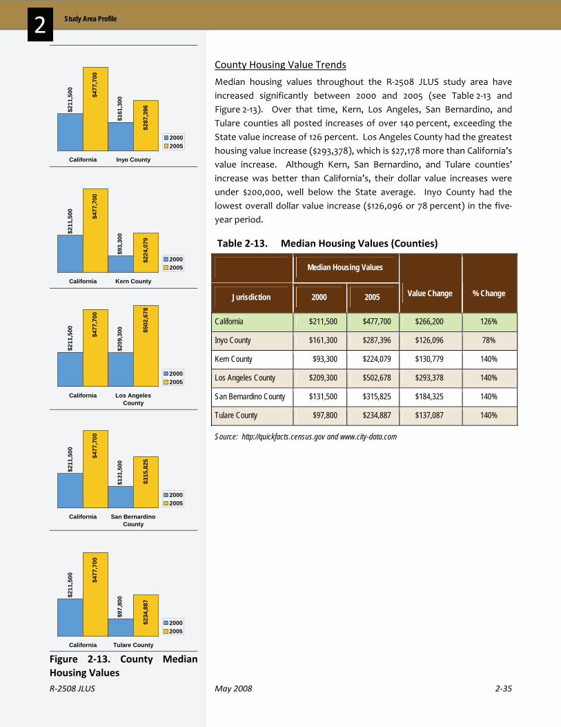
R‐2508 JLUS May 2008 2‐35
2 Study Area Profile
County Housing Value Trends
Median housing values throughout the R‐2508 JLUS study area have increased significantly between 2000 and 2005 (see Table 2‐13 and Figure 2‐13). Over that time, Kern, Los Angeles, San Bernardino, and Tulare counties all posted increases of over 140 percent, exceeding the State value increase of 126 percent. Los Angeles County had the greatest housing value increase ($293,378), which is $27,178 more than California’s value increase. Although Kern, San Bernardino, and Tulare counties’ increase was better than California’s, their dollar value increases were under $200,000, well below the State average. Inyo County had the lowest overall dollar value increase ($126,096 or 78 percent) in the five‐year period.
Table 2‐13. Median Housing Values (Counties)
Median Housing Values
Jurisdiction 2000 2005 Value Change % Change
California $211,500 $477,700 $266,200 126%
Inyo County $161,300 $287,396 $126,096 78%
Kern County $93,300 $224,079 $130,779 140%
Los Angeles County $209,300 $502,678 $293,378 140%
San Bernardino County $131,500 $315,825 $184,325 140%
Tulare County $97,800 $234,887 $137,087 140%
Source: http://quickfacts.census.gov and www.city-data.com
$211
,500
$161
,300
$287
,396
$477
,700
California Inyo County
20002005
$211
,500
$93,
300
$224
,079
$477
,700
California Kern County
20002005
$211
,500
$209
,300 $5
02,6
78
$477
,700
California Los AngelesCounty
20002005
$211
,500
$131
,500
$315
,825
$477
,700
California San BernardinoCounty
20002005
$211
,500
$97,
800
$234
,887
$477
,700
California Tulare County
20002005
Figure 2‐13. County Median Housing Values

2‐36 May 2008 R‐2508 JLUS
2 Study Area Profile
City Housing Value Trends
As with median housing values for the counties in the region, the cities in this area have also experienced impressive housing value increases between 2000 and 2005 (see Table 2‐14 and Figure 2‐14). Increases of over 160 percent for Hesperia, Lancaster, Palmdale and Victorville are above the percent value increases of Los Angeles and San Bernardino counties, as well as California. The cities of Adelanto, Apple Valley, and Barstow had percentage increases greater than San Bernardino County, but the dollar value increases were well below the county’s increase of $184,325. Bakersfield posted a housing value increase of nearly 147 percent, which is the largest percent increase in Kern County. As with population growth and housing unit trends, the City of Ridgecrest did not follow Kern County’s trend in housing values for the five‐year period. Ridgecrest saw the lowest value increase at $91,100.
Table 2‐14. Median Housing Values (Cities)
Median Housing Values
Jurisdiction 2000 2005 Value Change % Change
California $211,500 $477,700 $266,200 126%
Adelanto $81,700 $200,300 $118,600 145%
Apple Valley $112,700 $273,800 $161,100 143%
Bakersfield $106,500 $263,000 $156,500 147%
Barstow $75,700 $185,600 $109,900 145%
Bishop $145,200 $307,600 $162,400 112%
California City $81,900 $185,000 $103,100 126%
Hesperia $95,900 $272,400 $176,500 184%
Lancaster $103,700 $273,100 $169,400 163%
Palmdale $116,400 $303,800 $187,400 161%
Ridgecrest $72,400 $163,500 $91,100 126%
Tehachapi $90,000 $203,200 $113,200 126%
Victorville $98,700 $263,600 $164,900 167%
Source: http://quickfacts.census.gov and www.city-data.com
R‐2508 JLUS May 2008 2‐37
2 Study Area Profile
$81,
700
$131
,500
$315
,825
$200
,300
Adelanto San BernardinoCounty
20002005
$112
,700
$131
,500
$315
,825
$273
,800
Apple Valley San BernardinoCounty
20002005
$106
,500
$93,
300
$224
,079
$263
,000
Bakersfield Kern County
20002005
$75,
700
$131
,500
$315
,825
$185
,600
Barstow San BernardinoCounty
20002005
$145
,200
$161
,300
$287
,396
$307
,600
Bishop Inyo County
20002005
$81,
900
$93,
300
$224
,079
$185
,000
California City Kern County
20002005
$95,
900
$131
,500
$315
,825
$272
,400
Hesperia San BernardinoCounty
20002005
$103
,700 $2
09,3
00 $502
,678
$273
,100
Lancaster Los AngelesCounty
20002005
$116
,400 $209
,300 $5
02,6
78
$303
,800
Palmdale Los AngelesCounty
20002005
$72,
400
$93,
300
$224
,079
$163
,500
Ridgecrest Kern County
20002005
$90,
000
$93,
300
$224
,079
$203
,200
Tehachapi Kern County
20002005
$98,
700
$131
,500
$315
,825
$263
,600
Victorville San BernardinoCounty
20002005
Figure 2‐14. City Median Housing Values

2‐38 May 2008 R‐2508 JLUS
2 Study Area Profile
2 . 5 C o u n t y a n d C i t y P r o f i l e s
This section contains a brief overview of the counties with land within the study area and cities in and near the study area. Within the study area are also a number of unincorporated communities. A list of these locations is provided in Appendix D.
Inyo County is California’s second largest county (6,546,534 acres) and lies in the east‐central portion of the state at the border of Nevada. Nearly 78 percent (5,096,627 acres) lies within the JLUS study area. Most of Death Valley National Park lies within this county, and Kings Canyon and Sequoia National Parks border the county along the northwestern edge. In addition to Death Valley National Park, large portions of the county, primarily in the Sierra Nevada and White Mountains, are managed by the U.S. Forest Service and BLM. Within the Owens Valley, the Los Angeles Department of Water and Power owns a significant portion of the valley lands. Only about 2 percent of Inyo County is privately held.
United States Highway (Highway) 395 is the main route for transportation in the county, running in a north‐south direction that cuts through the western section of the county. Other major routes include Highway 6, State Route (SR) 127, SR 168, SR 178 and SR 190. Bus service is provided along Highway 395 through the Inyo‐Mono Transit service, and local service is provided in Bishop.
Bishop is the only incorporated city in the county. Unincorporated communities within the county include Big Pine, Cartago, Darwin, Deep Springs, Dixon Lane‐Meadow Creek, Furnace Creek, Homewood Canyon‐Valley Wells, Independence, Keeler, Lone Pine, Mesa, Olancha, Pearsonville, Round Valley, Shoshone, Tecopa, West Bishop, and Wilkerson. The unincorporated community of Independence is the county seat.
Based on 2007 data, Inyo County has experienced a 0.6 percent population increase since the 1990 Census. The overall growth figure was impacted by a 1.9 percent decrease between 1995 and 2000. However, the county’s population is projected to grow nearly 37 percent between 2007 and 2050.
IInnyyoo CCoouunnttyy

R‐2508 JLUS May 2008 2‐39
2 Study Area Profile
Kern County is California’s third‐largest county, with a land area of 5,221,414 acres. Of that total, 2,465,607 acres are within the R‐2508 study area. Kern County has three distinct regions. The western half of the county is located in the Central Valley area, and is a major agricultural production area in the State. To the east of the valley section is the southern end of the Sierra Nevada Range, which separates the valley portion of the county from the upper desert region to the east. This area is the western edge of the R‐2508 Complex and the location of the City of Tehachapi. The eastern quarter of the county is in the desert. In this area is the City of Ridgecrest as well as portions of China Lake and Edwards AFB. Much of the growth in eastern Kern County is taking place in unincorporated communities such as Mojave and Rosamond.
Although located just west of the study area, Interstate 5 and SR 99 serve as the main north‐south arteries in Kern County. In the upper desert area and adjacent to Edwards AFB, the main north‐south route is SR 14. Other major routes of importance to the study area include United States Highway 395 near NAWS China Lake and SR 58, 65, 178, and 223.
Based on 2007 data, Kern County has experienced a 47 percent population increase since the 1990 Census. The county’s population is projected to grow over 162 percent between 2007 and 2050.
Bordered by the Pacific Ocean to the west, Los Angeles County includes seventy five miles of coastline and includes San Clemente and Santa Catalina islands.
Los Angeles has the largest population of any county in the nation. The San Gabriel Mountains, containing Angeles National Forest, lay at the center of the county. The total land area of Los Angeles County is 2,613,721 acres, of which only 54,885 acres (two percent) are within the R‐2508 study area.
Los Angeles County is interwoven with many major transportation systems; however, the key transportation corridors impacting the study area are SR 14, 18, and 138.
There are 88 cities within the county with the largest cities including El Monte, Glendale, Lancaster, Long Beach, Los Angeles, Palmdale, Pasadena, Pomona, Santa Clarita, and Torrance. The cities of Lancaster and Palmdale lie close to Edwards AFB in the Antelope Valley and are adjacent to the south end of the R‐2508 JLUS study area.
KKeerrnn CCoouunnttyy
LLooss AAnnggeelleess CCoouunnttyy

2‐40 May 2008 R‐2508 JLUS
2 Study Area Profile
Based on 2007 data, Los Angeles County has experienced a 16.6 percent population increase since the 1990 Census. The county’s population is projected to grow over 26 percent between 2007 and 2050.
Located in southeast California, San Bernardino County is the largest county in California and the continental United States. The desert and mountain areas of the county extend west from Los Angeles County to Nevada. The land area makes up 12,867,878 acres, of which 2,979,923 acres are in the study area. Interstates 15 and 40 run through the county from the northeast and southeast and meet at Barstow. Other major transportation routes within or near the study area include United States Highway 395 and SR 58, 127, and 178.
Incorporated communities near the R‐2508 study area include Adelanto, Apple Valley, Barstow, Hesperia, and Victorville. All of Fort Irwin / NTC is located within the county. Part of China Lake also sits within the northwest border area, and a small portion of Edwards AFB lies along the west‐central border.
Based on 2007 data, San Bernardino County has experienced a 43 percent population increase since the 1990 Census. The county’s population is projected to grow nearly 55 percent between 2007 and 2050.
Tulare County is located centrally within the State of California, south of the City of Fresno. The eastern half of the county is comprised of mostly public lands within the Sequoia and Kings Canyon National Park, National Forest, and the Mineral King, Golden Trout, and Domelands Wilderness Areas. The county includes a land area of 3,099,323 acres, of which 1,364,752 acres (11 percent) are in the R‐2508 study area.
A portion of Porterville is the only city in Tulare County located in the R‐2508 study area. None of the cities within the county have critical encroachment issues in the R‐2508 JLUS study area. None of the installations inside the R‐2508 study area lie within the county.
Based on 2007 data, Tulare County has experienced a population increase of nearly 38 percent since the 1990 Census. The county’s population is projected to grow nearly 140 percent between 2007 and 2050, which is the second highest of the counties in the study area.
SSaann BBeerrnnaarrddiinnoo CCoouunnttyy
TTuullaarree CCoouunnttyy
R‐2508 JLUS May 2008 2‐41
2 Study Area Profile
The City of Adelanto is located on 53.5 square miles of land in the Mojave Desert. It lies 35 miles north of the City of San Bernardino and is within San Bernardino County. The Angeles National Forest lies to the south of the city, Barstow approximately 30 miles to the north and Edwards AFB sits approximately 20 miles to the northwest. Adelanto benefits from southwest winds that offer cool temperatures and a predominantly smog‐free environment.
The City of Adelanto was founded in 1915 by the inventor of the Hotpoint Electric Iron, E.H. Richardson. He divided and sold the land he purchased for $75,000 into one‐acre plots, hoping to create one of the first master planned cities, and to entice those with respiratory problems to reside in the unpolluted region. While his vision was not fulfilled, the community grew and was incorporated in 1970. The community would grow as a support community for the former George AFB, but this employment base would change over time as George AFB was closed as part of the 1988 BRAC process.
Based on 2007 data, the City of Adelanto has experienced a population increase of nearly 300 percent since the 1990 Census, and continues to show strong growth potential.
The Town of Apple Valley is located in the County of San Bernardino’s Victor Valley. The Town lies at the southern edge of the Mojave Desert and is bordered by the cities of Victorville and Hesperia. The City of Barstow is 37 miles to the north and the City of San Bernardino is 46 miles to the south. The city was incorporated in 1988, and has a total land area of 73.6 square miles.
Based on 2007 data, the Town of Apple Valley has experienced a population increase of nearly 53 percent since the 1990 Census.
The City of Bakersfield traces its roots to 1863 when former Iowa militia member and former California State Senator Colonel Thomas Baker moved into the Kern Island area to champion the cause of land reclamation. The city is located in Kern County, outside of the JLUS study area northwest of Edwards AFB. More specifically, Bakersfield lies near the southern end of the San Joaquin Valley, with the southern tip of the Sierra Nevada mountain range just to the east. The city limits extend to the Sequoia National Forest. To the south, the Tehachapi Mountains feature the historic Tejon Ranch. To the west is the Temblor Range,
CCiittyy ooff AAddeellaannttoo
TToowwnn ooff AAppppllee VVaalllleeyy
CCiittyy ooff BBaakkeerrssffiieelldd
2‐42 May 2008 R‐2508 JLUS
2 Study Area Profile
which features the Carrizo Plain National Monument and the San Andreas Fault, approximately 35 miles across the valley floor. The city's economy relies primarily on agriculture, petroleum extraction, and refinement industries.
Based on 2007 data, the City of Bakersfield has experienced a population increase of nearly 85 percent (148,235 people) since the 1990 Census.
The City of Barstow is located in the Mojave Desert within San Bernardino County. The city has its roots as a mining center for silver and borax. Barstow was named after the Santa Fe Railroad’s president William Barstow Strong. The railroad was built in the 1880’s to transport the mining products from the area, and by the early 1900’s, Barstow was growing as a city in the heart of a main transportation hub.
The city is located at the cross‐routes of Interstates 15 and 40 and is the closest city to Fort Irwin / NTC. Barstow has a total land area of 33.6 square miles.
Based on 2007 data, the City of Barstow has experienced a population increase of nearly 12 percent since the 1990 Census.
Located in Inyo County, just outside the northern edge of the R‐2508 Complex, the City of Bishop is the only incorporated city in Inyo County. The community was started in the 1860’s to supply beef to mining camps in the area. One of the first cattlemen to arrive in the area was Samuel Bishop, for whom the city is named. In 1903 the town incorporated officially as the City of Bishop.
The city is located at the base of the Sierra Nevada Range along Highway 395 and its intersection with Highway 6. Highway 395 runs the length of the Owens Valley and continues south through the study area and connects to Interstate 15 near the City of Hesperia. The city today continues to support agricultural activities in the area and is a center for tourism on the eastern side of the Sierra Nevadas.
Based on 2007 data, the City of Bishop has experienced a population increase of only three percent since the 1990 Census.
CCiittyy ooff BBaarrssttooww
CCiittyy ooff BBiisshhoopp
R‐2508 JLUS May 2008 2‐43
2 Study Area Profile
California City is located in southeast Kern County just north of Edwards AFB. The installation acts as a main employment center for the city. It lies in the Mojave Desert at the northern end of the Antelope Valley. The City of Ridgecrest is located to its north, the Tehachapi Mountains to the west and Palmdale and Lancaster to the south. The City of California City originated in 1958 with the purchase of 80,000 acres of land by a real estate developer named Nat Mendelsohn. Mendelsohn had master planned the city in hopes of it becoming a model city to rival Los Angeles; however, this never came to fruition. California City has a land area of 203.6 square miles, and is one of the larger incorporated land areas in the State.
Based on 2007 data, the City of California City has experienced a population increase of over 120 percent since the 1990 Census.
The City of Hesperia is located 35 miles north of the City of San Bernardino. Adelanto lies to the west of Hesperia, Victorville to the north and Apple Valley to the east. It is the fourth largest city in the upper desert area with a total land area of 67.4 square miles.
The Mormon trail was established in the 1800’s and passed through the area now known as Hesperia. By 1845, the trail was well‐established and people began settling in the area. In 1847, the Atchison, Topeka and Santa Fe Railroad had its tracks completed, running through the town and in 1885, a train depot was built. That year, the area was given its official name after the Greek word Hesperia, or “star of the west.”
Based on 2007 data, the City of Hesperia has experienced a population increase of over 70 percent since the 1990 Census.
The City of Lancaster is located in Los Angeles County in the Antelope Valley and adjacent to the City of Palmdale. It is located between the San Gabriel and Tehachapi Mountain Ranges, which lie to the north and south. The completion of the Southern Pacific Railroad route running from San Francisco to Los Angeles greatly contributed to the growth of Lancaster. In the late 1800’s, mining prospectors were drawn to the city in search of gold located in the Lancaster hills and borax in the Antelope Valley. Edwards AFB has continued to be a local economic contributor to the city since the 1930’s. Lancaster was incorporated as a city in 1977 and has since grown as individuals working in the Los Angeles metropolitan
CCiittyy ooff CCaalliiffoorrnniiaa CCiittyy
CCiittyy ooff HHeessppeerriiaa
CCiittyy ooff LLaannccaasstteerr
2‐44 May 2008 R‐2508 JLUS
2 Study Area Profile
area move to the city due to its affordable housing. Lancaster measures 94 square miles in area.
Based on 2007 data, the City of Lancaster has experienced a population increase of nearly 48 percent since the 1990 Census.
With a land area of 105.1 square miles, the City of Palmdale is located just south of Lancaster in the Antelope Valley. It lies at the eastern edge of the San Gabriel Mountain Range, which separates Palmdale from the City of Los Angeles. Palmdale was established as a village in 1886 by travelers arriving from the Midwest. The migrants were told to look for palm trees to distinguish their arrival to the ocean, but being that they had never seen such plant, they saw Joshua Trees and settled in the area, naming it “Palmenthal.” The settlers relocated closer to the Southern Pacific Railroad line in 1899 and called the settlement Palmdale.
As with neighboring Lancaster, agriculture was the main source of economy for the city until the establishment of Muroc Air Base, now Edwards AFB, in 1933. The aerospace industry continues to be the main economic contributor to this day. The city was incorporated in 1962 and has experienced rapid growth over the past few decades.
Based on 2007 data, the City of Palmdale has experienced a population increase of nearly 111 percent since the 1990 Census.
The City of Ridgecrest emerged as a town in 1943 with the establishment of Naval Ordnance Test Station, China Lake. Prior to that period, it was an association of a few farms and homes. During the 1950’s and 60’s, it grew as a support community to the China Lake installation, and it remains in that role today. Both the installation and the city rely upon each other: the city for employment and the base for housing and services.
Ridgecrest is located in the Indian Wells Valley portion of Kern County, and is surrounded by the Cosos Mountains on the north, the Argus Range on the east, the Sierra Nevadas on the west, and the El Paso Mountains on the south. The nearest urban centers are Lancaster/Palmdale, located 80 miles away, and Bakersfield and San Bernardino located about 125 miles away. Ridgecrest is the urban center for northeastern Kern County. Ridgecrest’s incorporated and unincorporated areas combine to a land area of 42 square miles.
CCiittyy ooff PPaallmmddaallee
CCiittyy ooff RRiiddggeeccrreesstt

R‐2508 JLUS May 2008 2‐45
2 Study Area Profile
Based on 2007 data, the City of Ridgecrest has experienced a population decrease of just over 1 percent since the 1990 Census. Between 1990 and 2000, the city experienced a decrease of over 10 percent; however, the subsequent five years showed an increase of nearly 6 percent (1,401 people). Population in the community is strongly linked to changes in employment at China Lake.
The City of Tehachapi is located in the Tehachapi Mountain Range between Bakersfield and Mojave in Kern County. It is located northwest of Edwards AFB. The city is known for its wind turbines and the Tehachapi Loop, which was completed by engineers for the Southern Pacific Railroad in 1876. The town started seeing growth after the completion of the rail depot in the late 1800’s and became incorporated as a city in 1909. To the northeast of the city is a limestone mine and cement plant that has been operating since 1908, which also attributed to the growth of the small city. The city has a land area of 9.6 square miles.
Based on 2007 data, the City of Tehachapi has experienced a population increase of just over 111 percent since the 1990 Census.
The City of Victorville is located in San Bernardino County in the Mojave Desert’s Victor Valley. The city is surrounded by the smaller High Desert cities of Adelanto, Apple Valley, and Hesperia. The San Bernardino and San Gabriel mountains form boundaries, separating Victorville and its surrounding High Desert communities from other urbanized areas.
Victorville had its beginning as a community called Victor, which was formed during the construction of the Southern Railroad in the area in 1885. Agricultural development flourished in the area in the late 1800s, but at the arrival of the 20th century, the cement industry took over in the Victor Valley due to the discovery of large deposits of limestone and granite, and has since become the largest industry in the area. The United States Postal Service changed the city’s name to Victorville in 1901. Victorville was incorporated as a city in 1962, and today has a land area of 74.2 square miles.
Based on 2007 data, the City of Victorville has experienced a population increase of over 152 percent since the 1990 Census.
CCiittyy ooff TTeehhaacchhaappii
CCiittyy ooff VViiccttoorrvviillllee

2‐46 May 2008 R‐2508 JLUS
2 Study Area Profile
Please see the next page.

Section 3
Existing Plans, Studies, and Programs


33 EX I ST ING PLANS , STUD IES , AND PROGRAMS
R‐2508 JLUS May 2008 3‐1
This section provides an overview of the primary plans and programs that are currently used or applied in evaluating and addressing compatibility issues in the study area. Section 3.1 provides an overview of the applicable plans used by Naval Air Weapons Station (NAWS) China Lake, Edwards Air Force Base (AFB), and Fort Irwin National Training Center (NTC).
Section 3.2 highlights plans and programs currently used by local jurisdictions to address compatibility issues including an overview of each jurisdiction’s general plan and regulatory tools (e.g., tools codified through a formal action such as a zoning ordinance, subdivision ordinance, or building code). Most jurisdictions do not have specific regulatory tools for compatibility, although many common zoning regulations can apply to these issues. For example, zoning ordinances may include regulations on grading, dust control, height restrictions supplied for new structures, and so forth. This section also describes major community and specific plans within the study area.
Section 3.3 discusses plans and programs maintained by other agencies or organizations that relate to compatibility planning in the study area.
Section 3.4 provides an overview of the California Advisory Handbook for Community and Military Compatibility Planning, the State’s guidebook on compatibility planning.
Section 3.5, describes legislation and other regulations that directly apply to compatibility planning, and Section 3.6 provides information on other references dealing with compatibility planning.
In this section… Page 3.1 Installation Plans
3.2 Local Jurisdiction Planning Tools
3.3 Other Agency Plans
3.4 California Compatibility Handbook
3.5 Legislation and Other Regulations
3.6 Other Resources
3-2
3-6
3-21
3-29
3-30
3-36

3‐2 May 2008 R‐2508 JLUS
3 Existing Plans, Studies, and Programs
3 . 1 I n s t a l l a t i o n P l a n s
Comprehensive Plans
In many ways, a military installation is a small city, containing industrial areas, commercial uses, office and administrative areas, residential areas, recreation, open space, and an airport. Just like a city, it requires a comprehensive plan to meet current planning needs and to set a vision for meeting the challenges related to future growth and change. Like a city or county, this is where a land use plan contributes. The land use plan helps base personnel understand existing conditions, documents existing needs and future expectations, and provides the programs and projects that can help the base react effectively to an ever‐changing world.
Air Installations Compatible Use Zones
For China Lake and Edwards, another critical planning document is the Air Installations Compatible Use Zones (AICUZ) program (note: some Services use the singular form, Air Installation Compatible Use Zone). The AICUZ is a Department of Defense (DOD) planning program that was developed in response to incompatible urban development and land use conflicts around military airfields.
The AICUZ study seeks to develop a cooperative relationship between communities and military installations and provides land use compatibility guidelines designed to protect public health and safety, as well as maintain military readiness. As designed, the AICUZ study evaluates three components: noise, vertical obstructions, and accident potential zones.
Every Navy and Air Force installation with air operations has delineated at both ends of all active runways a set of three accident potential zones referred to as the Clear Zone (CZ), Accident Potential Zone I (APZ I), and Accident Potential Zone II (APZ II). These areas are determined based on a statistical analysis of all DOD aircraft accidents.
Natural Resource Planning
The policy of the DOD is to fully comply with applicable federal, state, and county laws, ordinances, regulations, and guidelines, specifically designed to protect and preserve the environment. The Sikes Act Improvement Amendments of 1997 requires that the DOD manage their natural resources while providing a sustained method for the multiple uses of those resources. The act also requires an Integrated Natural Resources Management Plan (INRMP). To guide natural resource management efforts on installation, China Lake, Edwards AFB, and Fort Irwin maintain an INRMP.
Understanding Noise…
A more detailed explanation on how noise is described is provided in Appendix C.
R‐2508 JLUS May 2008 3‐3
3 Existing Plans, Studies, and Programs
Comprehensive Land Use Management Plan – China Lake
The Comprehensive Land Use Management Plan (CLUMP) for China Lake (2005) serves as the installation’s guide to land management, containing land use guidelines and procedures for the management of military operations and environmental resources. The plan incorporates the following planning context to aid installation administrators with development:
• Provides an understanding of the need for a planning approach to development
• Outlines the region and military context
• Describes the current and future mission of the installation and how it relates to land use
• Sets forth a framework for land management and an implementation guide
AICUZ – China Lake
An interim China Lake AICUZ study was released in 2007. The previous AICUZ was approved in 1977, and Kern County and the City of Ridgecrest evaluated that document and enacted the AICUZ compatible land use provisions into their zoning ordinances and general plan. The 2007 AICUZ outlines noise and safety issues in relation to both the baseline (current) and prospective operational conditions of the base as laid out in the 2004 Environmental Impact Statement (EIS) for Proposed Military Operational Increases and Implementation of Associated Comprehensive Land Use and Integrated Natural Resources Management Plans. The proposed action in the EIS acts as a basis for the program laid out in the 2007 AICUZ. The installation’s cooperation with local government agencies is outlined in the introduction to the AICUZ, which states the responsibility of the Navy to inform and cooperate with the planning departments of Kern and San Bernardino counties along with the City of Ridgecrest. As noted above, this study is an interim report, and after further evaluation, including the impact of the Joint Strike Fighter, an updated AICUZ may be released.
The study proposes an expansion of the traditional AICUZ planning area, called a Military Influence Area (MIA), to address the higher safety risks in these areas.
CChhiinnaa LLaakkee
3‐4 May 2008 R‐2508 JLUS
3 Existing Plans, Studies, and Programs
INRMP – China Lake
The China Lake INRMP addresses threatened and endangered species, habitat conservation, water resources conservation, grazing management and resources, and data inventory.
General Plan – Edwards AFB
The General Plan for Edwards AFB provides decision makers with an overview of installation development patterns and growth, as well as a vision of the installation’s capability for supporting its mission in relation to physical assets. The plan incorporates the following planning context to guide development:
• Highlights findings and recommendations for development to guide the base into a sustainable future
• Provides a regional profile and an overview of installation missions and current, related development plans
• Outlines constraints and opportunities in relation to land use
• Provides a maintenance plan to keep the general plan up‐to‐date
AICUZ – Edwards AFB
Edwards AFB is exempt from publicly releasing a full AICUZ study since all noise contours and accident potential zones are located within the base boundaries.
Real Property Master Plan – Fort Irwin / NTC
The Fort Irwin / NTC Real Property Master Plan is dated November 1996. The plan is currently undergoing an update, which is expected to be completed by mid‐2008. The current plan focuses on development and land use within the installation boundary and has limited discussion of off‐installation issues.
INRMP – Fort Irwin / NTC
The Fort Irwin INRMP addresses and provides a management plan on threatened and endangered species, fish and wildlife, forestry, grazing and cropland, pest management, land, and outdoor recreation.
FFoorrtt IIrrwwiinn // NNTTCC
EEddwwaarrddss AAFFBB

R‐2508 JLUS May 2008 3‐5
3 Existing Plans, Studies, and Programs
Integrated Cultural Resources Management Plan (ICRMP)
The Fort Irwin ICRMP addresses and provides a management plan that integrates cultural resources management mission objectives and follows the requirement as defined in Army Regulation (AR) 200‐4 using the guidance found in the Department of the Army Pamphlet (DA PAM) 200‐4. The ICRMP was written to serve as a five‐year plan starting in 2008 for the integrated management of the historic properties contained within Fort Irwin, San Bernardino County, California.
The following goals proposed in the ICRMP are recommendations for best management practices and provide some of the highlights of the document:
Inventory additional acreages within high‐probability areas for archaeological sites that are within high‐ and medium‐use areas
Conduct survey and site evaluations for the updating of six
ranges and construction of two new ranges as part of the Range Complex Modernization Program
Schedule National Register of Historic Places (NRHP) eligibility
evaluations of known sites within existing ranges and within the new Avawatz range in anticipation of necessary development (simulated villages, expanded staging areas, etc.)
Maintain cultural resources staffing with qualified professionals.
This is required by the PA and essential to the continued implementation of the cultural resources management program
Conduct an ethnographic study with appropriate tribes to
determine the presence or absence of Traditional Cultural Properties within Fort Irwin
Evaluate Cold War‐era buildings built between 1954 and 1963
that are either 50 years of age or will be within the next five years
Conduct an ethnographic study to determine if Brigade artwork
at the Painted Rocks monument at the entrance to Fort Irwin warrants designation as a Traditional Cultural Property (TCP)
Continue consultation with Native American tribes that have a
historical association with the geographic region
Continue reorganization of the curation system so that data are available and correct and so that fragile objects and material are properly conserved and protected

3‐6 May 2008 R‐2508 JLUS
3 Existing Plans, Studies, and Programs
Integrate the developing geographical information system (GIS)
cultural resources database into the day‐to‐day management of resources at Fort Irwin
3 . 2 L o c a l J u r i s d i c t i o n P l a n n i n g T o o l s
In this section, local jurisdictions that are located in the JLUS study area are discussed in alphabetical order, first by county and then by city.
Every county and city in California is required by state law to prepare and maintain a planning document called a general plan. A general plan is designed to serve as the jurisdiction’s “constitution” or “blueprint” for future decisions concerning land use, infrastructure, public services, and resource conservation. All specific plans, subdivisions, public works projects, and zoning decisions made by the city or county must be consistent with the general plan.
A general plan typically has three defining features:
General. As the name implies, a general plan provides general guidance that will be used to direct future land use and resource decisions
Comprehensive. A general plan covers a wide range of social, economic, infrastructure, and natural resource factors. These include topics such as land use, housing, circulation, utilities, public services, recreation, agriculture, Native American cultural resources, biological resources, and many other topics
Long‐range. General plans provide guidance on reaching a future envisioned 20 or more years in the future
The purpose of a general plan is to:
Identify the jurisdiction’s land use, circulation, environmental, economic, and social goals and policies as they relate to future development in the jurisdiction
Provide a basis for local government decision‐making, including decisions on development approvals
GGeenneerraall PPllaannss
Adding Compatibility Tools in General Plans…
Included in Section 4 are recommendations to update local general plans in order to specifically address compatibility issues related to the R‐2508 study area.
R‐2508 JLUS May 2008 3‐7
3 Existing Plans, Studies, and Programs
Provide citizens with opportunities to participate in the planning and decision‐making processes of their communities
Inform citizens, developers, decision‐makers, other cities and counties, and other organizations (such as military installations and federal agencies) of the policies that guide development within a particular community
For many of the jurisdictions in the study area, compatibility between jurisdictional lands and an installation is not specifically addressed as part of a policy statement. Instead, protections are addressed through general policies that apply to any project and location, such as policies addressing acceptable noise levels. Protections are also developed during a project’s environmental review as required by the California Environmental Quality Act (CEQA) and implemented through the appropriate mitigation measures that may be recommended by this process.
Fresno County
While a portion of Fresno County is inside the R‐2508 study area, all of the affected land is inside the Sequoia Kings Canyon National Park. Therefore, the county’s existing plans and programs do not impact the JLUS study area.
Inyo County
Inyo County last updated their General Plan in 2001. The updated plan reflects “the land use policy changes made by the federal government such as the expansion of Death Valley National Park, expansion of wilderness areas resulting from the Desert Protection Act, changes in the role of China Lake Naval Weapons Center, and proposals for a high‐level nuclear waste repository at Yucca Mountain.”
The updated components of the plan, which can be accessed online from http://www.westplanning.com, include the General Plan Summary, Goals and Policies Report, and Land Use and Circulation Diagrams. Included within the Goals and Policies Report is a Government Element, which addresses the collaborative efforts that will be maintained between the county and federal agencies playing a role in land management. Specifically, China Lake is mentioned in this Element and will work with the county to ensure land use compatibility and operational sustainability on the lands it manages at the southern portion of the county.

3‐8 May 2008 R‐2508 JLUS
3 Existing Plans, Studies, and Programs
Communication Outreach
Goal GOV‐1. Ensure plans prepared by agencies, districts, utilities, and Native American tribes are consistent with the county’s General Plan.
Policy GOV‐1.1. The county shall work with federal and state agencies, local districts, utilities, and Native American tribes to ensure that they are aware of the contents of the county’s General Plan to the greatest extent possible
Goal GOV‐2. To provide opportunities of early and consistent input by Inyo County and its citizens into the planning processes of other agencies, districts, and utilities.
Policy GOV‐2.1. The county shall continue its participation on the Collaborative Planning Team and work to expand participation to all affected government agencies
Policy GOV‐2.2. The county shall work with federal and state agencies, local districts, utilities, and Native American tribes to ensure that the county and the public are involved early in any planning process and that routine feedback and public input is requested
Noise
Policy NOI‐1.8. The county will encourage other government agencies to implement noise‐reducing measures when impacts to receptors within the County’s jurisdiction occur.
Kern County
The Kern County General Plan was last comprehensively updated in 2004. The General Plan is available for public review online at: http://www.co.kern.ca.us/planning/pdfs/kcgp/KCGP.pdf
Kern County adopted its current Housing Element in 2002, in order to meet a state‐imposed deadline for this element. The Kern County General Plan Housing Element 2002 – 2007 does not directly address China Lake or Edwards AFB in the goals and policies. The county is currently preparing an update for the General Plan Housing Element as required by law by June 2008 which will include housing issues regarding military readiness. Recommendations from the JLUS will be evaluated for inclusion.

R‐2508 JLUS May 2008 3‐9
3 Existing Plans, Studies, and Programs
The county is preparing a Military Readiness Element that will be finalized and renewed for adoption as an amendment to the Kern County General Plan after the R‐2508 JLUS is complete. This Element will consider the impact of new growth on military readiness activities carried out on military installations, and operating and training areas.
The following specific goals and policies and implementation measures are noted as being specifically relevant to compatibility planning.
Land Use
1.6 Residential.
Goal 8. Ensure compatible land uses around airports.
Policy 12. Prior to approval, all new discretionary residential projects located in the Airport Influence Areas will be reviewed for compatibility with the Airport Land Use Compatibility Plan
Implementation Measure D. All General Plan Amendments, zone changes, conditional use permits, discretionary residential developments of five or more dwelling units, and variations from height limits established by zoning for properties which are located in the Airport Influence Areas or near a military airport shall be reviewed by the Planning Department for compatibility with the Kern County Airport Land Use Compatibility Plan
Communication Outreach
1.2 Non‐Jurisdictional Land.
Goal 1. To promote harmonious and mutually beneficial uses of land among the various jurisdictions and land management entities present in Kern County.
Policy 1. Coordination and cooperation will be promoted among the county, the incorporated cities, military bases, and the various special districts where their planning decisions and actions affect more than a single jurisdiction
Policy 4. The county will solicit comments and coordinate with local governments, the military, and other federal or state jurisdictions on projects which are proposed within a peripheral area established mutual agreement between the county and the jurisdiction
3‐10 May 2008 R‐2508 JLUS
3 Existing Plans, Studies, and Programs
Implementation Measure E. Seek Memorandums of Understanding with other governmental entities when the land use proposed requires a discretionary application or coordination through the county Planning Agency as required by state or federal law. These applications include permit(s) subject to the Surface Mine and Reclamation Act (SMARA) of 1975
Implementation Measure F. The county shall consider all public agency comments for land use projects and promote intergovernmental coordination in the provision of land use designations and related public infrastructure
Light and Glare
1.10.7 Light and Glare.
Policy 47. Ensure that light and glare from discretionary new development projects are minimized in rural as well as urban areas
Policy 48. Encourage the use of low‐glare lighting to minimize nighttime glare effects on neighboring properties
Implementation AA. The county shall utilize CEQA Guidelines and the provisions of the Zoning Ordinance to minimize the impacts of light and glare on adjacent properties and in rural undeveloped areas
Air Quality
1.10.2 Air Quality.
Policy 18. The air quality implications of new discretionary land use proposals shall be considered in approval of major developments. Special emphasis will be placed on minimizing air quality degradation in the desert to enable effective military operations and in the valley region to meet attainment goals
R‐2508 JLUS May 2008 3‐11
3 Existing Plans, Studies, and Programs
Airport Land Use Compatibility
2.5.2 Airport Land Use Compatibility Plan (ALUCP)
Policy 1. Review land use designations and zoning near public and private airports, Edwards Air Force Base and Naval Air Weapons (NAWS) China Lake for compatibility
Implementation B. Coordinate and cooperate with airport operators, the County Department of Airports, the California Department of Transportation, Division of Aeronautics, affected cities, Edwards Air Force Base, NAWS China Lake and the Department of Defense on the ALUCP, review of land use applications, public education and encroachment issues
Los Angeles County
Los Angeles County is currently conducting a General Plan update process to modernize its existing 1980 General Plan. The draft General Plan Update document is available for review online at: http://planning.lacounty.gov
A Housing Element update for the Los Angeles County General Plan is also underway. The county is currently using the 1998 – 2005 Housing Element of the plan. The Constraints on Housing section discusses compatible land use; however, there is no mention of the installations involved in the R‐2508 JLUS in the Housing Element. The Land Use Element of the General Plan Draft Update does acknowledge the need to ensure land use compatibility in areas adjacent to military installations and where military operations, testing and training activities occur (Policy LU 3.7).
A component of the general plan is the Antelope Valley Areawide General Plan, dated 1986. This component makes reference to the Valley’s relationship with Edwards and China Lake. One of the purposes of this plan is to ensure land use compatibility between the county and government agencies.
Land Use
The following policies are proposed for the comprehensive update of the county’s most recently adopted General Plan. These amended items have not yet been officially adopted by the county.
3‐12 May 2008 R‐2508 JLUS
3 Existing Plans, Studies, and Programs
Goal LU‐3. Development that is compatible with surrounding neighborhood character and the natural environment.
Policy LU 3.4. Ensure airport operation compatibility with adjacent land uses through Airport Land Use Plans
Policy LU 3.7. Ensure land use compatibility in areas adjacent to military installations and where military operations, testing and training activities occur
Policy LU 3.8. Utilize buffer zones to reduce the impacts of incompatible land uses where feasible
San Bernardino County
San Bernardino recently completed a General Plan Update. The 2007 San Bernardino County General Plan is available online at: http://www.sbcounty.gov/landuseservices/General%20Plan%20Update/General%20Plan%20Text/FINAL%20General%20Plan%20Text%20‐%203‐1‐07_w_Images.pdf
The San Bernardino General Plan expresses the need to preserve land and airspace serving national defense and to use cooperative planning with military installations to minimize land use conflicts. The importance of intergovernmental coordination is discussed in the Land Use Element of the General Plan, stating the need to resolve potential land use conflicts between the DOD and the county in order to ensure that development meets the criteria of the plan.
Land Use
Goal LU 11. Promote mutually beneficial uses of land to address regional problems through coordination and cooperation among the county, the incorporated cities, Southern California Association of Governments (SCAG), San Bernardino Associated Governments (SANBAG), the various special districts and other local, state, and federal agencies.
Policy LU 11.2. Establish a “review area” around each state, military, or other federal installation, and review development proposals within each review area with the appropriate agency
Policy LU 11.3. Work with the Bureau of Land Management (BLM), US Forest Service (USFS), and other public agencies to eliminate conflicts between public and private lands, and to designate and protect wilderness and restricted natural areas
Policy LU 11.7. Work with Indian tribes and state and federal agencies in the development of plans for land within tribal and governmental jurisdictions
Draft policy statements…
In order to reflect their draft status (i.e., not adopted), Goal LU‐3 and supporting policy statements are shown as bulleted items, and are not identified with a yellow text box.

R‐2508 JLUS May 2008 3‐13
3 Existing Plans, Studies, and Programs
Noise
Policy N 2.2 The County will continue to work aggressively with federal agencies, including the branches of the military, the USFS, BLM, and other agencies to identify and work cooperatively to reduce potential conflicts arising from noise generated on federal lands and facilities affecting nearby land uses in unincorporated county areas
Communication Outreach
Policy LU 11.1. Foster intergovernmental cooperation among federal, state, and local agencies on key land use decisions
Safety
Policy S 8.1. Ensure the safety of airport operations and surrounding land uses
Programs
1) Adopt the Land Use Compatibility / Aviation chart as applicable to all discretionary and ministerial applications for Safety Overlay Districts delineated on the Hazards Overlay Maps. Safety areas are defined as follows:
a) That area defined within an adopted Airport Comprehensive Land Use Plan
b) That area defined within an adopted Interim Airport Land Use Plan (where there is no adopted Airport Comprehensive Land Use Plan)
c) That area defined within a low‐altitude/high‐speed corridor designated for military aircraft operations [see Existing Policy AV‐1a]
Tulare County
The Tulare County General Plan Update 2030 is currently in progress with a public draft issued in January 2008. The public review documents of the plan are available online at: http://generalplan.co.tulare.ca.us/
3‐14 May 2008 R‐2508 JLUS
3 Existing Plans, Studies, and Programs
The Goals and Policies Report of the revised plan mentions the county’s role in cooperation with the military to sustain the goals set out in the general plan. Goal PF‐6 of the report sets policies for the coordination and cooperation between local jurisdictions and federal agencies. These policies necessitate the involvement of the military to uphold the county general plan.
Land Use
City of California City
The city’s existing General Plan was adopted in 1993 based on a comprehensive update. This plan covers up to the year 2012. It is currently being updated with a completion date yet to be determined. The existing plan recognizes the city’s strong link with Edwards AFB to the south and identifies the special use airspace corridors located over the city.
City of Ridgecrest
The latest adoption of a General Plan for the City of Ridgecrest was in 1991. The city is currently preparing an update to its General Plan, which will be completed in 2008. The new plan will include a Military Sustainability Element to consider the impact of new growth on military readiness activities, in particular at China Lake. It will address the city’s dual objective of achieving economic development protecting the flight corridors and military missions associated with the installation.
The Map Atlas for Ridgecrest is a document that outlines current conditions for the city in a graphic and easily digestible format. The elements outlined in this document give a brief overview of what will be
Goal PF‐6. The County shall work with Tulare County cities; adjacent counties and cities; federal, state, and regional agencies; local districts; utility providers; Native American tribes; and the military to ensure that they are aware of the contents of the County’s General Plan to ensure that their plans are consistent with Tulare County’s General Plan to the greatest extent possible.
Policy LU‐1.3. The County shall discourage the intrusion into existing urban areas of new incompatible land uses that produce significant noise, odors, or fumes
Policy LU‐6.2. The County shall ensure that residential and other non‐compatible land uses are separated and buffered from major public facilities such as landfills, airports, and sewage treatment plants
Three cities in R‐2508…
Section 2 included cities from the study area and the surrounding region in order to provide context to growth pressures from the region. Only three cities lie within the R‐2508 study area: California City, Ridgecrest, and Tehachapi. This section focuses on these three jurisdictions since their plans and programs have the greatest impact on current compatibility planning.
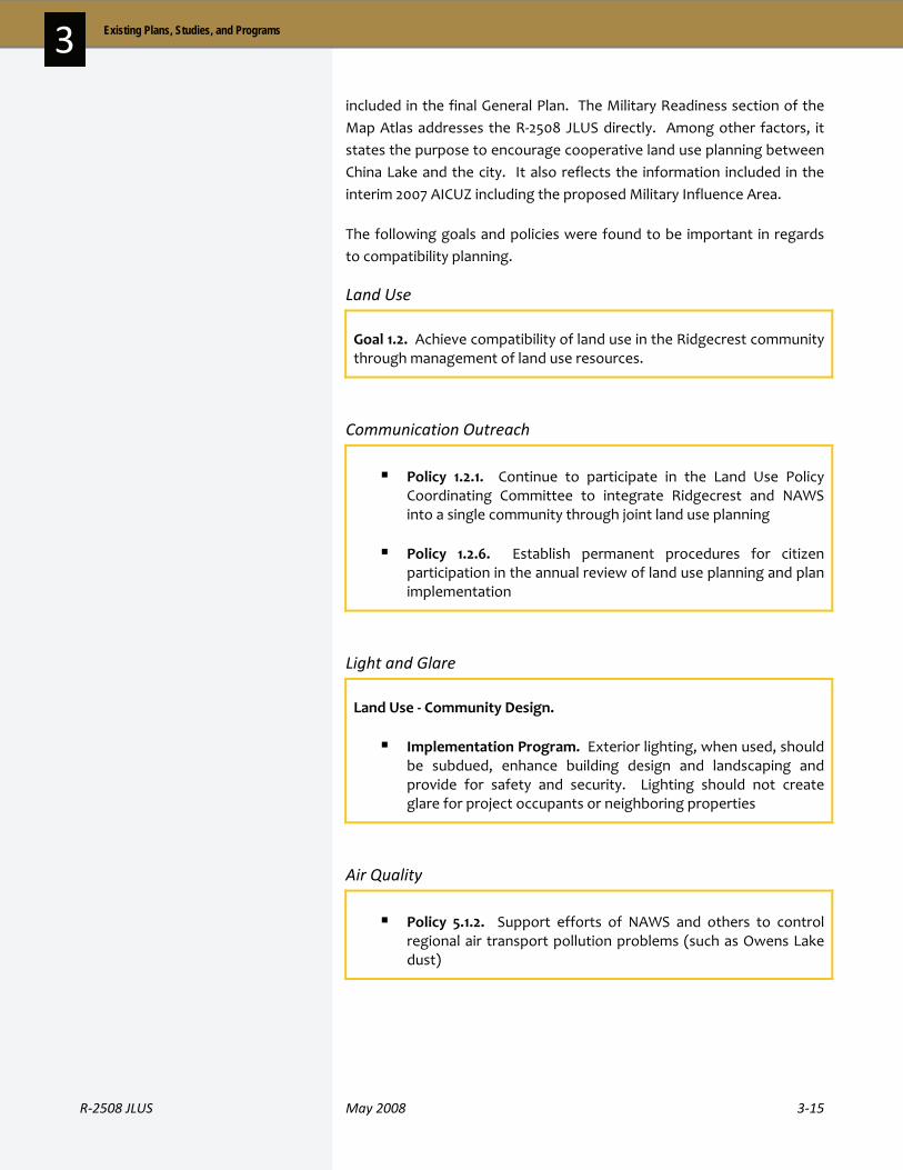
R‐2508 JLUS May 2008 3‐15
3 Existing Plans, Studies, and Programs
included in the final General Plan. The Military Readiness section of the Map Atlas addresses the R‐2508 JLUS directly. Among other factors, it states the purpose to encourage cooperative land use planning between China Lake and the city. It also reflects the information included in the interim 2007 AICUZ including the proposed Military Influence Area.
The following goals and policies were found to be important in regards to compatibility planning.
Land Use
Goal 1.2. Achieve compatibility of land use in the Ridgecrest community through management of land use resources.
Communication Outreach
Policy 1.2.1. Continue to participate in the Land Use Policy Coordinating Committee to integrate Ridgecrest and NAWS into a single community through joint land use planning
Policy 1.2.6. Establish permanent procedures for citizen participation in the annual review of land use planning and plan implementation
Light and Glare
Land Use ‐ Community Design.
Implementation Program. Exterior lighting, when used, should be subdued, enhance building design and landscaping and provide for safety and security. Lighting should not create glare for project occupants or neighboring properties
Air Quality
Policy 5.1.2. Support efforts of NAWS and others to control regional air transport pollution problems (such as Owens Lake dust)

3‐16 May 2008 R‐2508 JLUS
3 Existing Plans, Studies, and Programs
Noise
Policy 7.2.1. Actively encourage compliance with Air Installation Use Zone (AICUZ) land use objectives within the Indian Wells Valley with the provision that federal implementation procedures and policies be periodically re‐evaluated
Policy 7.2.2. Discourage growth inducing capital improvements within areas impacted by military aircraft operations
Safety
Policy 8.1.13. Support NAWS efforts to achieve compatible land uses within the “Accident Potential Zone” and “NAWS Drop Potential Zone” identified with the AICUZ program
City of Tehachapi
The elements contained in the City of Tehachapi General Plan went through a comprehensive update last in 1996 and 1999. The General Plan does not mention military installations directly in relation to land use compatibility.
Land Use
Land Use Goal 11 Objective C. Adopt performance criteria within appropriate ordinances to ensure land use compatibility, environmental protection, and improvement of neighborhoods identified in the Land Use Element of the general plan.
The General Plan Update states the land use goal to “separate incompatible land uses for functional productivity, reduction of nuisance and improvement of health and safety, and combine compatible land uses for efficiency and convenience.”
Other City Plans
Although outside the study area, the following status of general plans in other communities participating in the study is as follows:
The City of Lancaster is expecting completion of its General Plan Update in 2009

R‐2508 JLUS May 2008 3‐17
3 Existing Plans, Studies, and Programs
The zoning ordinance (also referred to as a development code) is the primary mechanism whereby local governments influence the direction, type, use, density, and location of development. The primary purpose of zoning is to:
Protect public health, safety, and welfare
Protect against physical danger, particularly safety considerations for properties in proximity to military ranges or within military flight areas
Protect against common law nuisances – noise, vibration, air pollution, etc. – associated with military operations
Protect against aesthetic nuisances impacting military installations
Protect against “psychological nuisances” such as perceived and actual dangers associated with military operations
Regulation of uses impacting light, glare, air quality, and privacy issues
Provision of open space and agricultural preservation
Zoning ordinances enumerate uses permitted by right or are subject to the approval of a land use review process within each district. Local zoning ordinances and development codes are the primary means to designate defined geographic areas or zones that separate incompatible uses. Most ordinances also possess a means to grant discretionary permits, provided certain conditions are met. These discretionary permits are often referred to as Conditional Use Permits (CUP) or Special Use Permits (SUP).
In addition to land uses, the zoning ordinances sets the development standards for permitted land uses, densities or development, location of structures, building heights, setbacks, acreage requirements, and other standards.
Kern County has specific regulations designed to address military compatibility. Key among these provisions is Section 19.08.160 of the Kern County Zoning Ordinance which includes restrictions on the height of structures in military flight areas. The county must submit alterations to a structure in a given zone designated on the Red/Yellow/Green height restrictions map to the military planning authority to ensure that the structure will not impede upon the missions of the installation within a specified zone. However, one can process a request to the Board of Supervisors for approval in a height–restricted area based on certain findings, if the applicant does not receive concurrence by the military. A copy of the Red/Yellow/Green map is included in Appendix B.
ZZoonniinngg
3‐18 May 2008 R‐2508 JLUS
3 Existing Plans, Studies, and Programs
The following subsection provides an overview of the major community and specific plans approved within the study area (presented first by county). Kern County is the only county with adopted specific plans in the study area that directly relate to the compatibility issues covered in this JLUS. These are highlighted in the following paragraphs.
As required in the State of California, specific plans are tailored to a development’s individual attributes while remaining consistent with the larger municipality’s general plan. All of the following specific plans have incorporated elements of the Kern County General Plan into their policies and implementations.
All of the Kern County specific plans mentioned herein recognize Map Code 2.8 (Military Flight Operations). These are areas that are subjected to noise from military operations at Edwards AFB, China Lake, and the R‐2508 airspace. These areas include low level overflights and potential noise from on‐base equipment testing.
North Edwards Specific Plan
The North Edwards Specific Plan is located in the unincorporated area of Kern County in the Antelope Valley Area of the Mojave Desert. The plan was adopted in January of 1990 and covers 4,783 acres. The specific plan area is located adjacent and north of State Highway 58 and Edwards AFB.
Chapter 4, Noise Element, of the specific plan directly addresses Edwards AFB. Implementation Measure 4.1.4 requires that projects, such as but not limited to, land divisions, zones changes, and conditional permits within the Edwards Flight Corridor be reviewed by Edwards Flight Test Center prior to approval.
Implementation Measure 4.1.4 also requires sound attenuation measures be implemented in all new developments located in areas where the noise levels exceed adopted standards. It states, “these measures shall be required as part of any Precise Development (PD) Plan, conditional use permit, subdivision map, or where an acoustical report has been required.”
Rosamond Specific Plan
Rosamond is located on 17,280 acres in eastern Kern County, 11 miles north of Lancaster. The plan was adopted in November of 1989. It addresses commercial, industrial, and residential land uses, as well as other required elements such as noise and resource management.
OOtthheerr CCoouunnttyy PPllaannss
A specific plan…
A specific plan acts as the implementation tool of the policies outlined in a general plan. Although the sizes and context of the specific plan can vary, the plan must comply with the adopted general plan for the jurisdiction in which the development is located.
R‐2508 JLUS May 2008 3‐19
3 Existing Plans, Studies, and Programs
The southern part of Rosamond is located within a low level, high speed air corridor. This corridor is regularly used by military aircraft from Edwards AFB. For the Rosamond Specific Plan, a 2.8 Map Code is all land that is within one mile of the Military Flight Corridor centerline. The base is an important growth factor for Rosamond. The number of civilian jobs offered on‐base and the number of military personnel affects the population and housing in the community.
Policy 17 of Chapter 1, Land Use Element, Residential, states that residential use on land classified as sensitive or highly sensitive “shall be protected from excessive noise impacts within the Military Flight Corridor.” Implementation Measure 12 requires that future residential land divisions within the Military Flight Operations area be limited to a minimum lot size of 2.5 acres.
Policy 8 Land Use Element, Physical Constraints, Section 6 recognizes that all sensitive and highly sensitive land uses within areas that are affected by overflights from Edwards AFB be minimized. Implementations 8 through 12 require that residential use be limited to a minimum 2.5 acres lot size (Implementation 8), a requirement for a disclosure on property with a Map Code of 2.8 to let owners or renters know that the “property is within the Edwards Flight Test Corridor and may be subject to noise related to aircraft flight testing activities” (Implementation 9) and building heights in an area with a 2.8 Map Code must be consistent with the Airport Approach Height Combining (H) District (Implementation 10).
Chapter 5, Safety Element, Section 4 addresses Airports / Aircraft. This section looks at the Rosamond Skypark, a private airport, and Edwards AFB. Implementation 2 requires that all discretionary projects within the Edwards Flight Test Center Area of Influence be reviewed by the county for comments.
Willow Springs Specific Plan
The Willow Springs Specific Plan was adopted in March of 1992. It covers 50,560 acres in Antelope Valley in the vicinity of a low level, high speed air corridor. The Willow Springs community is located six miles west of Rosamond. The majority of the community was subdivided with no land use development uniform plan. The specific plan addresses residential, commercial, and industrial uses.
The Residential Section, Implementation 9, requires that any future land divisions be limited to a lot size of 2.5 acres unless permitted by Edwards AFB on land within a 2.8 Map Code.

3‐20 May 2008 R‐2508 JLUS
3 Existing Plans, Studies, and Programs
In the Seismic / Safety Element, Policy 6 states that all sensitive and highly sensitive land uses are minimized within areas that are exposed to overflights from Edwards AFB, and Implementation Measures 10 – 12 correspond to the policy. Implementation 10 limits the lot size of all residential land uses be a minimum of 2.5 acres, unless the Board of Supervisors and Edwards AFB approve another density. Implementation 11 requires property owners of land with a 2.8 Map Code designation be given a disclosure which states that the property is within the Edwards Flight Test Corridor and that they might be exposed to an excessive level of noise from base operations. Implementation 12 requires that building heights in the 2.8 Map Code be consistent with the standards for H District (Airport Approach Height Combining).
Implementation Measures 4, 7, and 8 of the Noise Element require noise attenuation of buildings through traditional methods, setbacks, and orientation to ensure that interior noise levels do not exceed 45dB Community Noise Equivalent Level (CNEL).
Mojave Specific Plan
The final Mojave Specific Plan was adopted in October of 2003 and covers nearly 31,000 acres. Since the beginning of the community, it has been known as a transportation hub. The military has had a history with the community dating back to 1942, when the Mojave Marine Corps Auxiliary Station opened. The community is highly dependent on motorists and truckers that pass through the area. The Mojave Airport and Edwards AFB have been major factors in bringing in people to the area.
Policy 3.1.4 of the Land Use Element encourages the recognition of Edwards AFB, NAWS China Lake, and the military airspace complex as essential to Mojave’s economic capability.
Goal 2 of the Noise Element and Objective 8.2 mitigates the effects of noise through effective land use planning. Policies 8.2.1 and 8.2.2 incorporate the land use compatibility standards and policies of the Kern County General Plan Noise Element and the Airport Land Use Compatibility Plan.
R‐2508 JLUS May 2008 3‐21
3 Existing Plans, Studies, and Programs
The City of Tehachapi is the only city with a specific plan in the study area that directly relates to the compatibility issues covered in this JLUS.
East Tehachapi Specific Plan
The East Tehachapi Specific Plan is a master planned project that is aimed at industrial, commercial, office, and mobile home development. The specific plan is intended to accommodate the City of Tehachapi’s growth in this area. The project site is 450 acres located in eastern Kern County. The majority of the land use will be low‐rise industrial. Proposed uses include but are not limited to manufacturing, research and development, warehousing and distribution, and multi‐tenant industrial uses. The focus for this project is less residential (14.3 percent) than industrial (58 percent), leading to an increase in employment opportunities.
3 . 3 O t h e r A g e n c y P l a n s
An Airport Land Use Compatibility Plan (ALUCP) is “a plan, usually adopted by a County Airport Land Use Commission (ALUC) or other entity established to accomplish land use compatibility planning, which sets forth policies for promoting compatibility between airports and the land uses which surround them.” (California Airport Land Use Planning Handbook, January 2002) California Senate Bill 1462 (see page 3‐33) extended the ALUCs to include cities that adjoin military installations.
State statutes require that, once an ALUC has adopted or amended an ALUCP, the entity with land use jurisdiction and any affected cities must: (1) update their general plans and any applicable specific plans to be consistent with the ALUC’s plan within 180 days (CA Government Code, §65302.3); or (2) take the required steps to overrule all or part of the ALUC’s plan. In addition, ALUCPs should be consistent with the safety and noise standards established in the AICUZ study prepared for military installations that fall within their purview.
The purpose of the ALUCP is to:
Establish procedures and criteria used to address compatibility issues when making planning decision regarding airports and surrounding land uses
Safeguard the general welfare of the people living near airports and the public in general
Kern County
Kern County uses an alternative process for airport land use planning as provided for in State Airport Law to address compatibility issues for land
AAiirrppoorrtt LLaanndd UUssee CCoommppaattiibbiilliittyy PPllaann
OOtthheerr CCiittyy PPllaannss
3‐22 May 2008 R‐2508 JLUS
3 Existing Plans, Studies, and Programs
use surrounding the 16 public use airports in the county. This alternative process was established in 1996 with the adoption of the Kern County Airport Land Use Compatibility Plan by Kern County and the affected incorporated cities of Bakersfield, California City, Delano, Shafter, Taft, Tehachapi, and Wasco. Management of the plan is coordinated by the Kern County Planning Department. In 2003, the plan was amended to include a Military Aviation chapter, which includes descriptions and policies for land use compatibility for China Lake, Edwards, and the R‐2508 Complex. The ALCUP is incorporated by reference in the General Plan and Metropolitan Bakersfield General Plan circulation element.
In addition to outlining land use policies to ensure compatibility between county public use airports and jurisdictions, the ALUCP also addresses the lands under the R‐2508 Complex, and details compatibility issues that may arise from current and potential military aviation activities. These issues are outlined in Section 4.17 Military Aviation of the Kern County ALUCP. The Military Aviation section of the ALUCP addresses issues of encroachment such as population growth, commercial development, towers, noise, air space conflicts, environmental pressures, and radio frequency conflicts. Notification procedures are outlined within this section as well, recommending that China Lake and Edwards receive notice of development that falls within the outlined categories listed in the plan.
Los Angeles County
The Regional Planning Commission acts as the Airport Land Use Commission for Los Angeles County. The Los Angeles County ALUC began the latest update of its 1991 Airport Land Use Plan (ALUP) in 2002. The ALUC produced two documents to its update, providing the ALUP and the Los Angeles County Airport Land Use Commission Review Procedures (ALUC RP). The ALUP provides procedure and policies unique to each individual airport and the ALUC RP provides generally applicable policies and procedures for airports within the county. General William J. Fox Airfield in Lancaster has a separate plan called the Fox Airfield Compatibility Plan, adopted in 2004.
The ALUC uses these plans as tools when reviewing development plans for airports and surrounding land uses. The plans also set criteria that local agencies and landowners are recommended to follow in the preparation of land use plans, ordinances, and the design of new development. The Los Angeles County General Plan includes airport planning issues in the Aviation Network and Airport Land Use Commission sections of its Circulation Element.

R‐2508 JLUS May 2008 3‐23
3 Existing Plans, Studies, and Programs
A modification of the Los Angeles County ALUC is its role to resolve decision standstills that may arise in the airport planning process amongst public agencies. Once an issue has been resolved by the ALUC, the agency may accept the adjudication or appeal the ALUC with a four‐fifths overrule vote.
San Bernardino County
San Bernardino County uses the alternative review procedures allowed by state law for the planning responsibilities of the Airport Land Use Commission (ALUC). The Planning Commission of each jurisdiction that has a public use airport within its boundaries acts as the ALUC for projects near these airports. There is no single comprehensive ALUCP for the county. Rather, there are 15 separate ALUCPs unique to each airport within the county.
The county general plan describes airport land use compatibility in the Safety Element under Policy S8.1, “Ensure the safety of airport operations and surrounding land uses.” This policy also mentions the requirement to address the ALUCPs to ensure that the review of development proposals is consistent in the land use planning process. Program 5 under Policy S8.1 directs projects in certain designated safety areas to be reviewed at discretion by the “appropriate military facility.”
Tulare County
The Tulare County Comprehensive Airport Land Use Plan (CALUP) is used by the county ALUC to assess airport land use planning concerns. The county’s 2030 General Plan Update Goals and Policies Report, which is currently being updated, describes land use surrounding airports in the Health and Safety Element Section 10.3 Airport Hazards. Policy HS‐3.1 states that the county will ensure that development surrounding airports will meet the criteria laid out in the adopted Tulare CALUP. Policy HS‐3.2 addresses land use compatibility by ensuring that development within the airport approach and departure zones meets Federal Aviation Administration (FAA) regulations addressing navigable airspace.
Major transportation corridors in proximity to the three installations within the R‐2508 Complex include Interstate 15, US Highway 395, and State Highways 14 and 58. US Highway 395 runs north‐south along the west side of NAWS China Lake and east side of Edwards AFB. Interstate 15 runs through the City of Barstow to the south of Fort Irwin / NTC.
RReeggiioonnaall TTrraannssppoorrttaattiioonn PPllaannss
3‐24 May 2008 R‐2508 JLUS
3 Existing Plans, Studies, and Programs
Transportation planning authorities relevant to the R‐2508 Complex area include the Kern County Council of Governments (Kern COG), the San Bernardino Associated Governments (SANBAG), and the Southern California Association of Governments (SCAG). These planning agencies develop Regional Transportation Plans to assess factors that will affect regional transportation and to project the transportation needs to sustain the region in the future. The plans attribute changes occurring in the region related to population, housing, economic, and employment growth as factors that affect the need for transportation improvements. Land use is one of the most important elements of effective transportation planning, and land use plans and policies, such as those assessed in the R‐2508 JLUS, are crucial to the transportation planning process.
Within the JLUS study area, major transportation projects are occurring along US Highway 395 and State Highway 14 with the widening of lanes. (See Figure 3‐1). These projects may impact military operations with traffic congestion and road closures and rerouting. The planning process for these projects is managed by the Kern COG. As outlined in the Regional Transportation Plan Destination 2030 Draft 2007, the Kern COG will facilitate communication with neighboring jurisdictions and agencies affected by projects regarding interregional land use issues.
There are a number of federal agency management plans that directly relate to the issues covered under this JLUS. The following paragraphs provide a summary of the key plans influencing the use of the lands within the R‐2508 study area.
California Desert Conservation Area (CDCA) Plan (1980, as amended)
The CDCA serves as a guide for the management of all BLM‐administered lands in the desert area in and around the R‐2508 study area. Three deserts are recognized in the conservation area: the Mojave, the Sonoran, and a small portion of the Great Basin. Within the CDCA plan boundaries are approximately 25 million acres, of which 12 million are public lands (see Figure 3‐2). The primary goal of the plan is to manage the overall maintenance of the land while planning for multiple use and sustained yield, all in hopes of alleviating some of the natural conflicts between a sensitive and complex environment with the constant movement of people and their activities.
Over the last several decades, the CDCA has been amended numerous times. In 1999, an update to CDCA was published to incorporate the
FFeeddeerraall MMaannaaggeemmeenntt PPllaannss

R‐2508 JLUS May 2008 3‐25
3 Existing Plans, Studies, and Programs

3‐26 May 2008 R‐2508 JLUS
3 Existing Plans, Studies, and Programs
Figure 3‐2. BLM Land Use Management Plans
147 amendments that had been approved since 1980. The 1999 version also incorporated changes resulting from the adoption of the California Desert Protection Act in 1994. Approved and planned updates are described in the following sections.
A large part of the public lands in and around the R‐2508 JLUS study area are guided by the CDCA plan. The plan itself recognizes the presence of the military. The Wilderness Element in Chapter 3 acknowledges that overflights of aircraft are expected at low levels and are not considered sufficiently detrimental on the wilderness setting in Class C areas (potential wilderness areas) to warrant a non‐suitability recommendation. Chapter 5, Implementation Process, encourages the Bureau of Land Management (BLM) to coordinate with the DOD and local military installations to ensure “that implementation of the California Desert Plan will be as consistent as possible with the missions and purposes of these bases.”
Implementation of the CDCA has also been amended through the development of more detailed Resource Management Plans (RMP). In the R‐2508 study area, applicable RMPs are the Bishop, Northern and Eastern Mojave, and West Mojave (by adoption date).
Caliente RMP (1997, update expected in 2008)
Occupying the western edge of the R‐2508 JLUS study area, the Caliente RMP planning area covers 13.8 million acres of land along the western side of the Sierras and continuing into the Central Valley and Central Coast regions of California. The Caliente Resource RMP will guide management of approximately 590,000 acres of public land and an additional 450,000 acres of Federal reserved mineral estate lands,
R‐2508 JLUS May 2008 3‐27
3 Existing Plans, Studies, and Programs
including rocks and islands along the California coast of Ventura, Santa Barbara and San Luis Obispo Counties.
The planning area has been divided into three separate management areas: Coast, Valley, and South Sierra. The South Sierra Management Area, the primary area with the R‐2508 study area, includes 276,000 acres of public land and approximately 196,000 acres of Federal reserved mineral estate. The larger blocks of public land lie near Lake Isabella, Walker Pass, Chimney Peak, and Three Rivers. The management area includes five designated wilderness units.
Bishop RMP (1993)
The Bishop RMP includes 750,000 acres of public lands in the eastern Sierra region of Inyo and Mono counties, and including the northern end of the Owens Valley in the R‐2508 study area. Key issues addressed in the RMP include recreation, wildlife habitat, and mineral resources.
Northern and Eastern Mojave RMP (2002)
The Northern and Eastern Mojave plan, referred to by the acronym NEMO, was approved in 2002. The NEMO planning area encompasses 2.7 million acres of BLM‐managed public lands in eastern San Bernardino and Inyo counties and the far eastern edge of Mono County. The plan outlines the conservation strategy to manage sensitive species and habitats on public lands administered by the BLM.
West Mojave RMP (2006)
The BLM signed the record of decision approving the West Mojave Plan (WEMO). The WEMO underwent an extensive, decade‐long public planning process that covered 9.3 million‐acres in the western Mojave Desert area. WEMO is designed to provide a comprehensive strategy to conserve and protect more than 100 listed or sensitive wildlife species and their habitats, including the desert tortoise and Mohave ground squirrel. WEMO directly impacts the planning and use of 3.3 million acres of public lands administered by BLM and is seen as the first step in approval of the long‐awaited West Mojave habitat conservation plan (HCP) being developed by San Bernardino, Kern, Los Angeles, and Inyo counties, federal and state agencies, and 11 cities.
Death Valley National Park General Management Plan (April 2002)
The Death Valley National Park covers most of the northeast half of the R‐2508 JLUS study area. This includes the northeastern part of NAWS China Lake, and Fort Irwin / NTC. The park covers 3,396,192 acres of land, the majority of which are in Inyo and San Bernardino counties. The park
3‐28 May 2008 R‐2508 JLUS
3 Existing Plans, Studies, and Programs
was established by presidential proclamation under the Antiquities Act in 1906. The last general management plan for the Death Valley National Park is dated 1989. The plan focuses on the special attributes of the park, as well as the mission of the various agencies that utilize the park in relation to the mission of the US National Park Service. It also determines and analyzes which activities are appropriate while protecting the resources of the park.
Inyo National Forest Land and Resource Management Plan (1988)
The Inyo National Forest stretches across five counties in California and two counties in Nevada. The forest covers nearly 2 million acres, of which 794,352 acres (41 percent) are located in Inyo County. The plan focuses on different elements of the forest, such as but not limited to, timber harvesting, grazing, and cultural resources. Due to the variety in the climate, vegetation, animals, and elevation in the forests, the management plan needed to be comprehensive and all‐encompassing.
Mojave National Preserve General Management Plan (April 2002)
The Mojave General Management Plan is an overall umbrella management tool that presents strategies for the future direction of the park. The park is located to the southeast of the Death Valley National Park. It was established in October of 1994 by the California Protection Act. The Mojave Park covers 1.6 million acres, of which 700,000 are designated as wilderness.
Sequoia and Kings Canyon National Parks Final General Management Plan and Comprehensive River Management Plan Environmental Impact Statement (2004)
The Sequoia and Kings Canyon National Parks are located northwest of the R‐2508 JLUS study area. Kings Canyon is located directly above Sequoia National Park; however, they are sometimes referred to as one entity.
The Sequoia and Kings National Parks Management Plan is intended to be a management guide for the future vision of the Sequoia and Kings National Parks. The plan was written in accordance with the National Environmental Policy Act (NEPA) and offers four alternatives with one preferred alternative.
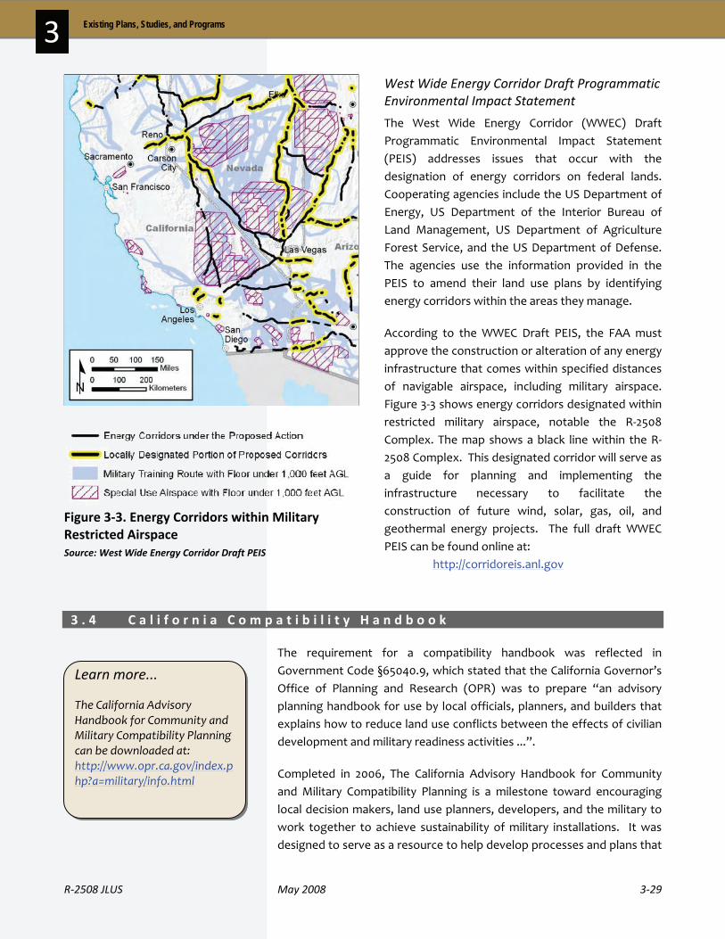
R‐2508 JLUS May 2008 3‐29
3 Existing Plans, Studies, and Programs
Figure 3‐3. Energy Corridors within Military Restricted Airspace Source: West Wide Energy Corridor Draft PEIS
West Wide Energy Corridor Draft Programmatic Environmental Impact Statement
The West Wide Energy Corridor (WWEC) Draft Programmatic Environmental Impact Statement (PEIS) addresses issues that occur with the designation of energy corridors on federal lands. Cooperating agencies include the US Department of Energy, US Department of the Interior Bureau of Land Management, US Department of Agriculture Forest Service, and the US Department of Defense. The agencies use the information provided in the PEIS to amend their land use plans by identifying energy corridors within the areas they manage.
According to the WWEC Draft PEIS, the FAA must approve the construction or alteration of any energy infrastructure that comes within specified distances of navigable airspace, including military airspace. Figure 3‐3 shows energy corridors designated within restricted military airspace, notable the R‐2508 Complex. The map shows a black line within the R‐2508 Complex. This designated corridor will serve as a guide for planning and implementing the infrastructure necessary to facilitate the construction of future wind, solar, gas, oil, and geothermal energy projects. The full draft WWEC PEIS can be found online at: http://corridoreis.anl.gov
3 . 4 C a l i f o r n i a C o m p a t i b i l i t y H a n d b o o k
The requirement for a compatibility handbook was reflected in Government Code §65040.9, which stated that the California Governor’s Office of Planning and Research (OPR) was to prepare “an advisory planning handbook for use by local officials, planners, and builders that explains how to reduce land use conflicts between the effects of civilian development and military readiness activities ...”.
Completed in 2006, The California Advisory Handbook for Community and Military Compatibility Planning is a milestone toward encouraging local decision makers, land use planners, developers, and the military to work together to achieve sustainability of military installations. It was designed to serve as a resource to help develop processes and plans that
Learn more...
The California Advisory Handbook for Community and Military Compatibility Planning can be downloaded at: http://www.opr.ca.gov/index.php?a=military/info.html
3‐30 May 2008 R‐2508 JLUS
3 Existing Plans, Studies, and Programs
would sustain local economies, safeguard military readiness, and protect the health and safety of California’s residents. The Handbook is a useful tool for development of a JLUS as it describes in detail the different compatibility issues that should be explored and the range of compatibility tools types available to address these issues.
3 . 5 L e g i s l a t i o n a n d O t h e r R e g u l a t i o n s
The following is an overview of existing legislation and policy that impacts compatibility planning.
Assembly Bill 1108
California Assembly Bill (AB) 1108 (Chapter 638, Statutes of 2002) amends CEQA law to require CEQA lead agencies to notify military installations when a project meets certain criteria. The purpose of AB 1108 is to ensure military notification of proposed projects potentially impacting military operations though the CEQA process.
AB 1108 amends CEQA to provide military agencies with early notice of proposed projects within two miles of installations or underlying training routes and special use airspace. To obtain this information, Edwards AFB, NAWS China Lake, and Fort Irwin / NTC must provide local planning agencies within the critical operations areas (COA) with the installation’s contact person, the relevant information, and boundaries of the installation’s COAs. The local lead agency is required to give notice to military installations of any project within their boundaries if: (1) the project includes a general plan amendment; (2) the project is of statewide, regional, or area wide significance; or (3) the project is required to be referred to the ALUC or appropriately designated body. This notification will provide the military installations with an opportunity to provide early input so potential conflicts can be evaluated and addressed proactively.
Assembly Bill 2641
The Native American Human Remains and Multiple Human Remains legislation (Chapter 863, Statutes of 2006) amends the Public Resources Code relating to burial grounds. The law authorizes a commission to act to prevent damage to Native American burial grounds or places of worship. The bill calls for meaningful discussion between descendents of those whose remains are found and landowners so the Native American human remains are identified and considered during development activities. The commission must contact the most likely descendents in the event of being notified by a county coroner of a Native American
SSttaattee LLeeggiissllaattiioonn

R‐2508 JLUS May 2008 3‐31
3 Existing Plans, Studies, and Programs
human remains discovery. Upon such discovery, the landowner must ensure that the surrounding area not be disturbed or damaged in the vicinity of the discovery location until discussion has taken place with the descendents regarding their recommendations. To protect sites where remains have been identified, the landowner must: record the site with the commission; use an open space or conservation zoning designation or easement; or, record a document with the county in which the property is located.
Assembly Bill 2776
The Aviation Noise Disclosure legislation (AB 2776, Chapter 496, Statutes of 2002) was passed in the 2001–2002 regular legislative session and was signed by the Governor. It amends the real estate transfer disclosure statute (California Civil Code, Division 2 – Property, Part 4 – Acquisition of Property, Title 4, Chapter 2 – Transfer of Real Property) to require sellers or leasers to disclose the fact that a house for sale or lease is near an airport if the house falls within an airport influence area (that could be several miles from an existing or proposed airport). An airport influence area is defined as the area in which current or future airport‐related noise, overflight, safety, or airspace protection factors may significantly affect land uses or necessitate restrictions on those uses. The intent of the legislation is to notify buyers that they could experience airport noise, vibration, odor, annoyances, or other inconveniences at some time in the future as a result of the normal operation of an existing or proposed airport.
Senate Bill 18
California Senate Bill (SB) 18 (Chapter 904, Statutes 2004) established the Native American Heritage Commission to bring on actions to prevent severe and irreparable damage to a Native American sanctified cemetery, place of worship, religious or ceremonial site, or a sacred shrine located on public property. It included entities able to acquire and hold conservation easements as federally recognized California Native American tribes or a non‐federally recognized California Native American tribe that is on the contact list maintained by the Native American Heritage Commission.
SB 18 required that on and after March 1, 2005, all planning agencies must refer to and provide involvement opportunities for California Native American tribes on proposed actions affecting tribes. Prior to the adoption or amendment of a city or county general plan, the jurisdiction must consult with California Native American tribes to preserve specified places, features and objects located within the jurisdiction.
3‐32 May 2008 R‐2508 JLUS
3 Existing Plans, Studies, and Programs
Senate Bill 1099
SB 1099 (Chapter 425, Statutes of 1999) established the California Defense Retention and Conversion Council in the Trade and Commerce Agency, active until January 1, 2007. The membership of this organization could include major executive branch agencies and public appointees. Representatives from California colleges and universities and California‐based branches of the United States Armed Forces could also participate as nonvoting members.
SB 1099 provided a provision to grant funds to communities to develop military base retention strategies. It also mandated the preparation of a study considering strategies for long‐term protection of lands next to military bases. This requirement was met in 2001 by a draft report entitled Forecasting and Mitigating Future Urban Encroachment Adjacent to California Military Installations: A Spatial Approach written by the University of California, Berkeley, Institute of Urban and Regional Development. According to the report, “more than half of California's military installations are located within, at the edge of, or within a stone's throw of major metropolitan areas.”
Senate Bill 1462
SB 1462 (Chapter 907, Statutes of 2004) expanded the requirements for local government to notify military installations of proposed development and planning activities. This statute states that “prior to action by a legislative body to adopt or substantially amend a general plan, the planning agency shall refer the proposed action to...the branches of the Armed Forces when the proposed project is located within 1,000 feet of a military installation, beneath a low‐level flight path, or within Special Use Airspace (SUA)...”.
The purpose of SB 1462 is to require public agencies to provide a complete copy of a development application of the proposed development that is located within 1,000 feet of a military installation, SUA, or a low‐level flight path. Furthermore, it authorizes any branch of the United States Armed Forces “to request consultation” to avoid potential conflict and to discuss “alternatives, mitigation measures, and the effects of the proposed project on military installations.” Also, SB 1462 requires military review of proposed actions potentially impacting mission operations of the installation, decreases potential for incompatible land use development and provides military installations the opportunity to comment on proposed development and express concerns with potential impacts to the installation.

R‐2508 JLUS May 2008 3‐33
3 Existing Plans, Studies, and Programs
Senate Bill 1468
SB 1468 (Chapter 971, Statutes of 2002) requires OPR to include guidance on how military compatibility can be addressed in a general plan, and how a general plan can consider the impact of growth on military readiness activities carried out on military bases, installations, and operating and training areas. The statute includes the following methods to address military compatibility in a general plan:
In the land use element, consider the impact of new growth on military readiness activities carried out on military bases, installations, and operating and training areas, when proposing zoning ordinances or designating land uses covered by the general plan for land or other territory adjacent to those military facilities, or underlying designated military aviation routes and airspace
In the open‐space element, open‐space land is defined to include areas adjacent to military installations, military training routes, and restricted airspace
In the circulation element, include the general location and extent of existing and proposed military airports and ports
SB 1468 is part of a State policy package to promote the development of a partnership between communities and the military that allows for collaboration on land use compatibility issues. OPR encourages local jurisdictions near military installations, and under military training routes or restricted airspace, to incorporate the above items into their general plans.
However, local governments are not currently required by law to include the SB 1468 military compatibility issues in their general plans. The bill specifies that if a funding agreement is reached between OPR and the military to support these efforts, the inclusion of military compatibility issues in a general plan will become mandatory.
California Environmental Quality Act / National Environmental Policy Act
The California Environmental Quality Act (CEQA) was enacted in 1970 to protect the environment by requiring public agencies to analyze and disclose the potential environmental impacts of proposed land use decisions. CEQA is modeled after the federal National Environmental Policy Act (NEPA).
EEnnvviirroonnmmeennttaall CCoommpplliiaannccee
3‐34 May 2008 R‐2508 JLUS
3 Existing Plans, Studies, and Programs
The purpose of CEQA is to inform agency decision makers and the public about the potential environmental effects of proposed activities. Using this information, decision makers can identify ways that environmental impacts can be avoided or significantly reduced by requiring the mitigation of significant environmental effects, when feasible.
The NEPA of 1969 requires Federal agencies to file an environmental assessment (EA) and sometimes an environmental impact statement (EIS) for major Federal actions that have an environmental impact. NEPA is applicable to all Federal agencies, including the military.
NEPA mandates that the military analyze the impact of its actions and operations on the environment, including that of the surrounding communities. Inherent in this analysis is an exploration of methods to lessen any adverse environmental impact. The EIS is a public process that allows participation by the community.
For local planning officials, an EIS or EA is a valuable planning document in determining the extent of impacts of changing military actions or operations on their policies, plans, and programs, if any, and on the surrounding community. Public hearings are required for all EIS and EA documents released by the military under NEPA. A Finding of No Significant Impact (FONSI) under an EA or a full EIS that considers alternatives to the proposed military actions or operations also is required and is subject to public scrutiny. The information obtained by the EIS/EA is valuable in planning coordination and policy formulation at the local government level.
The following is an overview of existing legislation and policy that impacts military activities and surrounding communities.
Air Installation Compatible Use Zone Program
The Air Installations Compatibility Use Zones (AICUZ) program is a DOD planning program developed in 1973 as a response to incompatible urban development and land use conflicts around military airfields. The AICUZ program seeks to provide information on compatibility, develop a cooperative relationship between communities and military installations, and provide land use compatibility guidelines that protect public health and safety and maintain military readiness. The purpose of an AICUZ is to:
Protect investment by safeguarding installation operational capabilities
FFeeddeerraall IInniittiiaattiivveess

R‐2508 JLUS May 2008 3‐35
3 Existing Plans, Studies, and Programs
Protect the health, safety, and welfare of civilians and military personnel by encouraging land use which is compatible with aircraft operations
Inform the public about the AICUZ program and seek cooperative efforts to minimize noise and aircraft accident potential impact by promoting compatible development in the vicinity of military air installations
DOD Conservation Partnering Initiative
In 2003, Congress amended Title 10 U.S.C. §§2684a and 2692a (P.L. 107‐314) to add authority to DOD to partner with other federal agencies, states, local governments, and conservation‐based Non‐Governmental Organizations (NGO) to set aside lands near military bases for conservation purposes and to prevent incompatible development from encroaching on, and interfering with, military missions. This law provides an additional tool to support smart planning, conservation, and environmental stewardship on and off military installations.
Federal Aviation Act
The Act requires the Secretary of Transportation to make long‐range plans to formulate policy for the orderly development and use of “navigable air space” to serve the needs of civilian aeronautics and national defense except for the specific needs of military agencies. Military planning strives to work alongside local, state, and federal aviation law and policies but sometimes must supersede other levels of government due to national security interests.
The ‘500‐foot rule’ is discussed in the Federal Aviation Act. It states that flights 500 feet or more above ground level (AGL) do not represent a compensable taking because flights 500 feet AGL enjoy a right of free passage without liability to the owners below. This is important to military installations and their surrounding communities when considering land acquisition and development rights.
Joint Land Use Study
A Joint Land Use Study (JLUS) is a collaborative planning effort between active military installations, surrounding counties and cities, and other affected agencies. The JLUS is an inter‐jurisdictional partnership that is funded by the DOD Office of Economic Adjustment (OEA). The JLUS process encourages residents, local decision‐makers, and installation representatives to study issues of compatibility in an open forum with the goal of balancing both military and community interests. The resulting recommendations are intended to reduce potential conflicts while accommodating growth, sustaining the economic health of the region, and protecting public health and safety.

3‐36 May 2008 R‐2508 JLUS
3 Existing Plans, Studies, and Programs
3 . 6 O t h e r R e s o u r c e s
In hopes of preventing land use compatibility issues between the military and the local community, the DOD Office of Economic Adjustment (OEA) and other public interest groups, such as the National Association of Counties (NACO), have taken steps to inform the public on encroachment issues and methods that can be used to address or completely avoid compatibility issues. Below are four resources that have been published to inform the public on those issues.
The Practical Guide to Compatible Civilian Development near Military Installations (July 2007), OEA. This guide offers general information on community development and civilian encroachment issues. The guide can be found at: http://www.oea.gov/.
Joint Land Use Study Program Guidance Manual (November 2006). This manual provides guidance on the JLUS program, process, and efforts to support compatible development. This manual can be obtained on the OEA internet site at the following address: http://www.oea.gov/.
Encouraging Compatible Land Use between Local Governments and Military Installations: A Best Practices Guide (April 2007), National Association of Counties. This guidebook presents case studies of best practices between the military and communities through communication, regulatory approaches, and Joint Land Use Studies. The guide can be accessed on the NACO internet site at the following address: http://www.naco.org/.
DDooccuummeennttss

R‐2508 JLUS May 2008 3‐37
3 Existing Plans, Studies, and Programs
The Base Next Door: Community Planning and the Joint Land Use Study Program, OEA. This informative video discusses the issue of encroachment on military installations as urban development occurs in the vicinity of installations.
Managing Growth, Communities Respond, OEA. This video highlights the lessons learned from three communities successful in managing growth near military installations.
VViiddeeooss

3‐38 May 2008 R‐2508 JLUS
3 Existing Plans, Studies, and Programs
Please see the next page.

Section 4
Recommendations


44 RECOMMENDAT IONS
R‐2508 JLUS May 2008 4‐1
This section provides a toolbox of strategies that have been developed cooperatively with representatives from local jurisdictions, China Lake, Edwards AFB, Fort Irwin / NTC, state and federal agencies, local organizations, Native American tribal governments, and other interested entities. The strategies represent a realistic and coordinated approach to compatibility planning developed with the support of the stakeholders involved.
4 . 1 D e v e l o p i n g R e c o m m e n d a t i o n s
There are several measures of a successful planning process. As described below, the JLUS process has met these requirements.
QQ Did the process provide for substantial involvement of those responsible for implementation?
AA The R‐2508 JLUS Advisory Committee (AC) and Technical Committee (TC) met throughout the development of the JLUS and provided input on each step of the study’s development. The committees assisted in the identification of compatibility issues (both current and future) and the development and refinement of the strategies presented in this section. The committee members’ insight also helped to develop a set of strategies that not only resolved the compatibility issues identified, but could realistically be implemented by the stakeholders involved.
The recommendations presented below represent a consensus that was supported by all members of the AC and TC.
In this section… Page 4.1 Developing
Recommendations
4.2 Recommended JLUS Strategies
4.3 Strategies Summarized by Agency and Timeline
4-1
4-3
4-51
4‐2 May 2008 R‐2508 JLUS
Recommendations 4
QQ Does the plan cover the geographic area necessary to ensure appropriate compatibility planning?
AA At the beginning of the JLUS process, the project team invited agencies and organizations from the surrounding region to be a part of the planning process and to assist in identifying any geographic area that may be important to the development and implementation of the plan.
QQ Are the proposed strategies realistic?
AA The design of the committees helped ensure that the plan would be realistic in approach. The AC represented decision makers from land‐use management agencies and the military organizations involved. They helped develop approaches that could be implemented. The TC represented the staff functions of these agencies and organizations and a broad range of other interested organizations. They helped refine the strategies and provided input on the processes, staffing, and funding necessary for implementation.
QQ Do the strategies strike a balance between sustaining military operations and providing opportunities for local economic development?
AA Bringing together all of the stakeholders and opening lines of communication on a wide range of compatibility issues started a higher level of communication on issues than had been achieved in the past. The consensus of both the AC and TC to support the JLUS is a testament to striking the right balance.
QQ Does the study include a mechanism to oversee the implementation of the JLUS recommendations?
AA Strategy 9 establishes a JLUS Coordinating Committee. Made up of representatives from the local jurisdictions, Native American tribal governments, and military installations in the study area, it will monitor, assess, and refine the requirements in this JLUS to address the changing conditions and ensure the JLUS provides a long‐term vision for meeting encroachment challenges.
R‐2508 JLUS May 2008 4‐3
4 Recommendations
4 . 2 R e c o m m e n d e d J L U S S t r a t e g i e s
There are a total of 61 recommended JLUS strategies. These strategies cover the broad range of compatibility issues discussed in Appendix C. The recommended strategies are presented in this section under the compatibility tool heading that best represents each strategy. There are 15 compatibility tool headings:
Acquisitions (Table 4‐2)
Airport Land Use Compatibility (Table 4‐3)
Avigation Easements (Table 4‐4)
Capital Improvements Programs (CIP) (Table 4‐5)
Communications / Coordination (Table 4‐6)
Deed Restrictions / Covenants (Table 4‐7)
General Plans / Management Plans (Table 4‐8)
Habitat Conservation (Table 4‐9)
Legislative Initiatives (Table 4‐10)
Light and Glare Control (Table 4‐11)
Memorandum of Understanding (MOU) (Table 4‐12)
Military Installation Operations (Table 4‐13)
Military Operations Areas (Table 4‐14)
Real Estate Disclosure (Table 4‐15)
Zoning / Subdivision / Other Regulations (Table 4‐16)
Figure 4‐1 provides a guide on how to read the strategies presented in Tables 4‐2 through 4‐16 in this section. In the tables describing strategies, the Responsibility / Partners column identifies what agency or organization is responsible for implementing the strategy (Primary Responsibility) and which agencies and organizations are considered to be Partners in the strategy. A Partner is simply an agency or organization that can provide technical information or can otherwise support the efforts to implement the strategy.
Recommended JLUS strategies presented by agency are located in Table 4‐17 and strategies presented by implementation timeline are located in Table 4‐18 in Section 4.3.

4‐4 May 2008 R‐2508 JLUS
Recommendations 4
Strategy Number. Used for reference.
Strategy. This column contains a description of the strategy, including actions to be taken.
Who Will Complete. This column lists the organizations with primary responsibility for the strategy, and the partners that can assist them with implementation.
When. These columns show when the strategy is proposed to be completed. Some strategies are also marked as “Ongoing” activities.
Figure 4‐1. Guide to Using Strategy Tables
Table 4‐1 provides an index of the strategies contained under each compatibility tool type. The corresponding page number for each strategy is also listed.
Table 4‐1. Index of Strategies Strategy Number, Title, and Location in Document
Acquisitions 1 Identify Mission-Critical Private Land Parcels ..........................................................................................................................................................4-9
Airport Land Use Compatibility 2 Update ALUCP to Reflect Military Air Facilities and Airspace................................................................................................................................4-11

R‐2508 JLUS May 2008 4‐5
4 Recommendations
Strategy Number, Title, and Location in Document
Avigation Easements 3 Consider Developing / Updating an Avigation Easement Program........................................................................................................................4-12
Capital Improvements Programs (CIP) 4 Promote Sustainable and Compatibility-Oriented Transportation Projects ............................................................................................................4-13 5 Investigate Critical Facilities Grade Separation......................................................................................................................................................4-13 6 Establish Plans and Requirements for Reclaimed Water.......................................................................................................................................4-13 7 Explore Use of Alternative Energy Sources ...........................................................................................................................................................4-14 8 Identify Gate Needs for Edwards AFB....................................................................................................................................................................4-14
Communications / Coordination 9 Establish a JLUS Coordinating Committee ............................................................................................................................................................4-15 10 Continue to Participate in Ground Water Management Group...............................................................................................................................4-16 11 Continue to Participate in Antelope Valley Water Group........................................................................................................................................4-16 12 Refer Development Applications to Military Installations for Review / Comment ...................................................................................................4-17 13 Develop an Educational Outreach Program ...........................................................................................................................................................4-18 14 Work to Ensure Availability of SUA Information .....................................................................................................................................................4-19 15 Coordinate for Military Vehicle Routes ...................................................................................................................................................................4-19 16 Provide Installation Information to Jurisdictions .....................................................................................................................................................4-20 17 Coordinate on Various Issues for Policy / Implementation Changes .....................................................................................................................4-21 18 Establish a Light and Glare Working Group ...........................................................................................................................................................4-22 19 Encourage Drought Tolerant Landscaping.............................................................................................................................................................4-23 20 Establish Procedures to Avoid Frequency Conflicts / Issues .................................................................................................................................4-24 21 Refer Specific BLM Development Applications to Military Installations for Review / Comment.............................................................................4-24 22 Create Planning Information Clearinghouse...........................................................................................................................................................4-25 23 Encourage Cellular Tower Collocation / Consolidation ..........................................................................................................................................4-26 24 Work to Ensure Marking of Utility Lines..................................................................................................................................................................4-26 25 Allow Military Review of Permit Applications ..........................................................................................................................................................4-26 26 Work to Evaluate Use of Existing Transmission Corridors .....................................................................................................................................4-27 27 Review / Amend Controlled Burn Procedures ........................................................................................................................................................4-27 28 Investigate Providing Guidance on Tower Location / Height..................................................................................................................................4-27 29 Address Conflicts with High Speed Rail and Highway Projects .............................................................................................................................4-28 30 Require Planning Coordination with Military ...........................................................................................................................................................4-28 31 Partner for BLM Lands............................................................................................................................................................................................4-29 32 Review Operational Guidelines for the Controlled Firing Area...............................................................................................................................4-29
Deed Restrictions / Covenants 33 Consider Developing an Enhanced Real Estate Disclosure Ordinance.................................................................................................................4-31
General Plans / Management Plans 34 Review of Management Plans for Military Compatibility.........................................................................................................................................4-33 35 Ensure Water Impacts in Plan Development / Updates .........................................................................................................................................4-33 36 Involve Military in General Plan Update Process ...................................................................................................................................................4-34 37 Evaluate Willow Springs Specific Plan Uses ..........................................................................................................................................................4-34 38 Consider Developing Methods to Address Frequency Spectrum Conflicts............................................................................................................4-35 39 Evaluate Rosamond Land Use Changes for Traffic Impacts..................................................................................................................................4-35 40 Consider Evaluating Urban / Rural Interface ..........................................................................................................................................................4-35 41 Investigate Infill and Densification ..........................................................................................................................................................................4-36 42 Include Military Housing Needs Discussion in General Plan Housing Element .....................................................................................................4-36 43 Evaluate Ridgecrest Sphere of Influence ...............................................................................................................................................................4-36 44 Evaluate California City Sphere of Influence ..........................................................................................................................................................4-37 45 Encourage Trip Reduction Techniques ..................................................................................................................................................................4-37
Habitat Conservation 46 Consider Regional Habitat Conservation Plan .......................................................................................................................................................4-38
Table 4‐1. Index of Strategies (continued)

4‐6 May 2008 R‐2508 JLUS
Recommendations 4 Strategy Number, Title, and Location in Document
Legislative Initiatives 47 Protect Military Missions with Wilderness Legislation ............................................................................................................................................4-39
Light and Glare Controls 48 Determine Dark Sky Funding Sources ...................................................................................................................................................................4-40
Memorandum of Understanding (MOU) 49 Evaluate Implementation of Military Emission Reduction System..........................................................................................................................4-41 50 Coordinate Military Ordnance Use and Location....................................................................................................................................................4-41
Military Installation Operations 51 Evaluate Rerouting of Military Flight Patterns ........................................................................................................................................................4-42
Military Operations Areas 52 Develop Area of Interest Designations for Operations Areas.................................................................................................................................4-43
Real Estate Disclosure 53 Provide UXO Information........................................................................................................................................................................................4-44 54 Develop / Modify Disclosure Notices for Military Operations..................................................................................................................................4-45
Zoning / Subdivision / Other Local Regulations 55 Use Subdivision Regulations to Minimize Impacts .................................................................................................................................................4-47 56 Determine Density Limitations Needs.....................................................................................................................................................................4-48 57 Consider Evaluating Use of China Lake Military Overlay District ...........................................................................................................................4-48 58 Consider Developing Regulations to Address Vertical Obstructions......................................................................................................................4-49 59 Consider Developing Solar Power Generation Guidelines.....................................................................................................................................4-50 60 Remove Residential Tower Exemptions.................................................................................................................................................................4-50 61 Identify and Mitigate Dust Constraints ....................................................................................................................................................................4-51
This JLUS is designed to provide strategies that can be applied by local jurisdictions, agencies, and organizations, therefore, it is important to be able to identify which strategies may apply to your group and when they should be implemented. To assist in this effort, tables are included at the end of this section that provide an easy cross‐reference to the information you need. Figures 4‐2 and 4‐3 illustrate how these tables are organized.
Strategy Summaries
Table 4‐1. Index of Strategies (continued)
R‐2508 JLUS May 2008 4‐7
4 Recommendations
Figure 4‐2. Sample Summary: Who Will Implement Each Strategy (Table 4‐17)
Figure 4‐3. Sample Summary: When Each Strategy Should Occur (Table 4‐18)
4‐8 May 2008 R‐2508 JLUS
Recommendations 4 As a land use planning tool, property rights can be acquired through donation, easement, or the outright purchase of property for public purposes. Types of acquisition include the following:
Fee Simple Acquisition. This option involves the purchase of property and is typically the most costly method to protect open space, sensitive, or critical areas. Cost and the need for a willing seller can be constraints
Fee Simple / Leaseback. A land trust is established when a government agency purchases the full title to a property, and then leases it back to the previous owner. The land’s natural resource and open space values are protected through lease controls that restrict land uses
Conservation Easement. Conservation easements can be acquired through a number of mechanisms, including donation or purchase. If they are donated, the donor could qualify for a federal income tax deduction making this option more desirable to the property owner. Conservation easements are a more cost effective method to acquire land than outright purchase
Lease. In cases where the landowner does not want to, or cannot make a permanent commitment, this may be a way to control land uses for a short timeframe. Leases can be obtained by government agencies or jurisdictions, non‐profit organizations, land trusts, or private entities
Management Agreement. A management agreement is a specified plan under which the landowner or the land trust (or combination thereof) will manage the land. Management agreements last for a specific amount of time making them a short‐term approach to protecting land
Eminent Domain. A local government can use the power of eminent domain to appropriate private property for public use, in exchange for payment of fair market value, through the process of condemnation
The purpose of acquisition tools is to eliminate land use incompatibilities through market transactions and the local development process. Acquisition tools are particularly effective because they advance the complementary goals of shifting future growth away from military installations and preserving community assets such as agriculture, open space, rural character, or sensitive natural habitats. Land use compatibility issues can be addressed by:
Creating a land barrier between active military installations and incompatible land uses
Shifting future growth away from critical military lands
Conservation easement…
A conservation easement is a legal agreement that a property owner voluntarily places on a piece of property to restrict the development, management, or use of the land. Landowners can be compensated directly (purchase) or can provide the easement to receive tax incentives. These easements are often used to protect a sensitive resource (such as a wetland or agricultural land) or provide for public use of private land, such as a trail.
Acquisitions
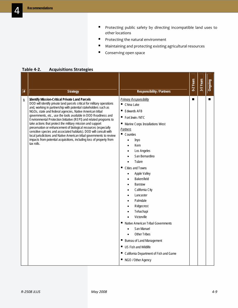
R‐2508 JLUS May 2008 4‐9
4 Recommendations
Protecting public safety by directing incompatible land uses to other locations
Protecting the natural environment
Maintaining and protecting existing agricultural resources
Conserving open space
Table 4‐2. Acquisitions Strategies
# Strategy Responsibility / Partners 0-2 Y
ears
3-5 Y
ears
Ongo
ing
1 Identify Mission-Critical Private Land Parcels DOD will identify private land parcels critical for military operations and, working in partnership with potential stakeholders such as NGOs, state and federal agencies, Native American tribal governments, etc., use the tools available in DOD Readiness and Environmental Protection Initiative (REPI) and related programs to take actions that protect the military mission and support preservation or enhancement of biological resources (especially sensitive species and associated habitats). DOD will consult with local jurisdictions and Native American tribal governments to review impacts from potential acquisitions, including loss of property from tax rolls.
Primary Responsibility China Lake
Edwards AFB
Fort Irwin / NTC
Marine Corps Installations West Partners Counties
• Inyo • Kern • Los Angeles • San Bernardino • Tulare
Cities and Towns • Apple Valley • Bakersfield • Barstow • California City • Lancaster • Palmdale • Ridgecrest • Tehachapi • Victorville
Native American Tribal Governments • San Manuel • Other Tribes
Bureau of Land Management
US Fish and Wildlife
California Department of Fish and Game
NGO / Other Agency
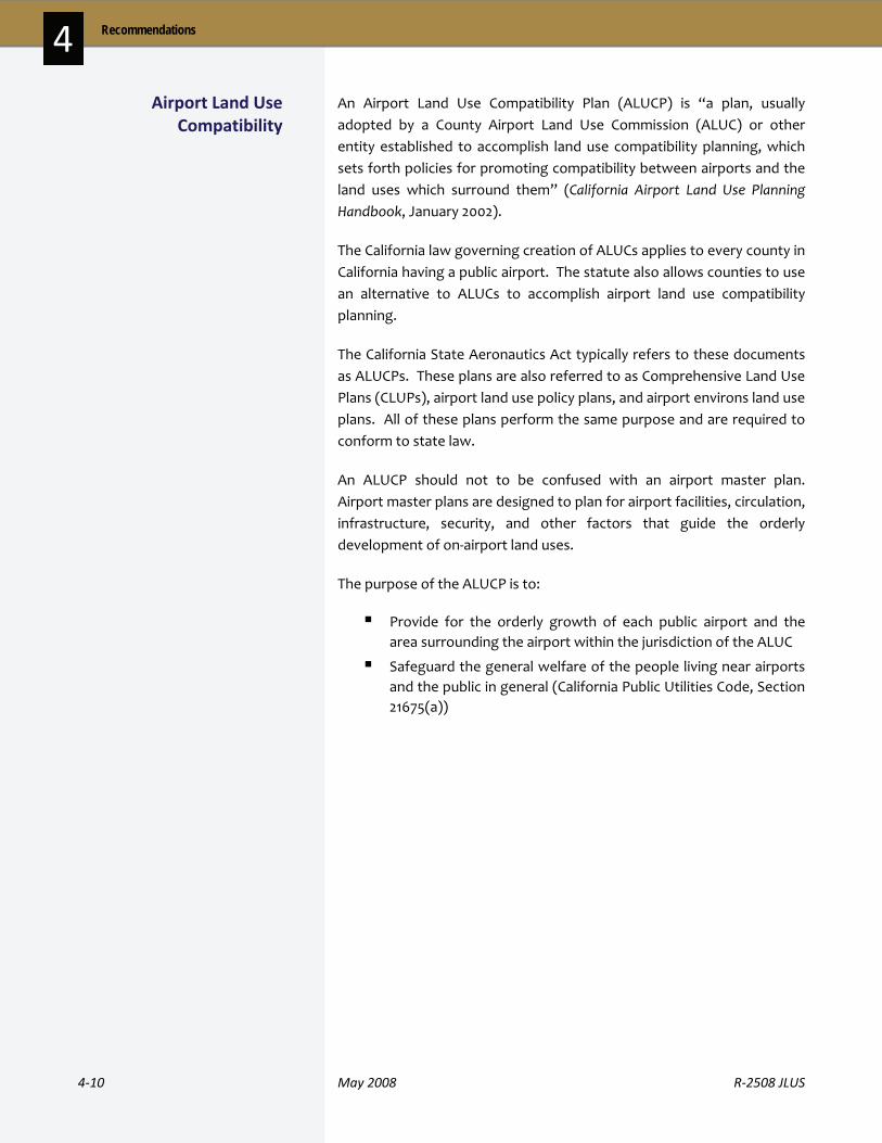
4‐10 May 2008 R‐2508 JLUS
Recommendations 4 An Airport Land Use Compatibility Plan (ALUCP) is “a plan, usually adopted by a County Airport Land Use Commission (ALUC) or other entity established to accomplish land use compatibility planning, which sets forth policies for promoting compatibility between airports and the land uses which surround them” (California Airport Land Use Planning Handbook, January 2002).
The California law governing creation of ALUCs applies to every county in California having a public airport. The statute also allows counties to use an alternative to ALUCs to accomplish airport land use compatibility planning.
The California State Aeronautics Act typically refers to these documents as ALUCPs. These plans are also referred to as Comprehensive Land Use Plans (CLUPs), airport land use policy plans, and airport environs land use plans. All of these plans perform the same purpose and are required to conform to state law.
An ALUCP should not to be confused with an airport master plan. Airport master plans are designed to plan for airport facilities, circulation, infrastructure, security, and other factors that guide the orderly development of on‐airport land uses.
The purpose of the ALUCP is to:
Provide for the orderly growth of each public airport and the area surrounding the airport within the jurisdiction of the ALUC
Safeguard the general welfare of the people living near airports and the public in general (California Public Utilities Code, Section 21675(a))
Airport Land Use Compatibility

R‐2508 JLUS May 2008 4‐11
4 Recommendations
Table 4‐3. Airport Land Use Compatibility Strategies
# Strategy Responsibility / Partners 0-2 Y
ears
3-5 Y
ears
Ongo
ing
2 Update ALUCP to Reflect Military Air Facilities and Airspace Fully integrate military air facilities and airspace in ALUCP updates. These updated ALUCPs will be used to update land use guidance in local jurisdiction general plans and zoning ordinances. ALUCPs may not be the correct tool to use for areas within low-level flight corridors and special use airspace areas that are not near a public use airport. In these cases, similar types of plans may be appropriate to address military concerns.
Primary Responsibility Counties
• Inyo • Kern • Los Angeles • San Bernardino • Tulare
Cities • California City • Ridgecrest
China Lake
Edwards AFB
Fort Irwin / NTC
Marine Corps Installations West Partners None
An easement is a non‐possessory right to use land owned by another party. An avigation easement is an easement that grants the holder one or more of the following rights: the right of flight; the right to cause noise, dust, or other impacts related to aircraft flight; the right to restrict or prohibit certain lights, electromagnetic signals, and bird‐attracting land uses; the right to unobstructed airspace over the property above a specified height; and, the right of ingress or egress upon the land to exercise those rights.
Avigation easements transfer certain property rights from the owner of the underlying property to another entity. This entity could be the owner of an airport or, in the case of military airports, to a local government agency or authorized federal agency on behalf of the military. The DOD is not authorized to accept avigation easements. Historically, if the military desires such easements, there are several ways they can be obtained. The US Army Corps of Engineers serves as the negotiator and the primary real estate agent for the Air Force.
Avigation Easements

4‐12 May 2008 R‐2508 JLUS
Recommendations 4 Entities acquire avigation easements to the airspace over neighboring properties to: (1) prevent construction of buildings and towers, planting of trees, installation of lighting, or any other development that might interfere with aircraft takeoff and landing, or (2) protect against liability for any nuisance caused by aircraft using the airport (i.e. noise, fumes, and vibration) that might impact the use and enjoyment of properties adjacent to an airfield or under its flight paths.
Table 4‐4. Avigation Easements Strategies
# Strategy Responsibility / Partners 0-2 Y
ears
3-5 Y
ears
Ongo
ing
3 Consider Developing / Updating an Avigation Easement Program Consider the development of an avigation easement program, which includes sample easement language, designates areas where avigation easements should be required, and determines the appropriate agency to hold such easements.
Primary Responsibility Counties
• Inyo • Kern • Los Angeles • San Bernardino
Cities and Towns • Apple Valley • Bakersfield • Barstow • California City • Lancaster • Palmdale • Ridgecrest • Tehachapi • Victorville
Partners China Lake
Edwards AFB
Fort Irwin / NTC
Marine Corps Installations West

R‐2508 JLUS May 2008 4‐13
4 Recommendations
A Capital Improvements Program (CIP) is a detailed fiscal and planning document used to plan and direct a jurisdiction’s or agency’s investment in public facilities, including infrastructure. The CIP lays out the public facilities plans and programs of the jurisdiction or agency and provides details on expenditures that can be incorporated into the jurisdiction’s or agency’s annual budgeting process. Most CIPs cover multiple years to plan for major expenditures and projects that may occur over several years. Jurisdictions can influence where and when growth will take place through capital investment decisions, such as the placement of roadways or other infrastructure systems.
Table 4‐5. CIP Strategies
# Strategy Responsibility / Partners 0-2 Y
ears
3-5 Y
ears
Ongo
ing
4 Promote Sustainable and Compatibility-Oriented Transportation Projects Work with COGs, Caltrans, and US Department of Transportation to promote transportation projects that further sustainable and compatible land use and circulation patterns. Project funds for needed highway and road improvements (i.e., land expansions, overcrossings, etc.) should be promoted.
Primary Responsibility Counties
• Kern
Cities • California City • Ridgecrest
Caltrans Partners Councils of Governments
5 Investigate Critical Facilities Grade Separation Work with Public Utilities Companies, railroads, and Kern County to investigate implementation of a grade separation for critical facilities near installation access points (where needed).
Primary Responsibility Counties
• Kern
Councils of Governments Partners NGO / Other Agency
6 Establish Plans and Requirements for Reclaimed Water Work with the City of Lancaster and Los Angeles County to establish plans and requirements for the use of reclaimed water from District 14 plant.
Primary Responsibility Counties
• Los Angeles
Cities • Lancaster
Edwards AFB
NGO / Other Agency Partners None
Capital Improvements Programs (CIP)

4‐14 May 2008 R‐2508 JLUS
Recommendations 4
# Strategy Responsibility / Partners 0-2 Y
ears
3-5 Y
ears
Ongo
ing
7 Explore Use of Alternative Energy Sources When building new structures, explore use of alternative energy sources.
Primary Responsibility China Lake
Edwards AFB
Fort Irwin / NTC Partners None
8 Identify Gate Needs for Edwards AFB Kern and Los Angeles County Roads Departments, affected local jurisdictions, Kern COG, and Edwards AFB will work together to determine if gate improvements or an additional entry gate is necessary. If found to be required, work to implement through the County's CIP and/or Regional Transportation Plan for off-installation improvements and Edward's funding process for gate improvements and appropriate manning. Jointly pursue outside funding sources (Caltrans, OEA, etc.).
Primary Responsibility Counties
• Kern • Los Angeles
Cities • California City • Lancaster • Palmdale
Edwards AFB
NGO / Other Agency Partners None
In any planning effort, plans can only move toward successful implementation if there are ongoing communications between military installations in the JLUS study area, local jurisdictions, agencies, landowners, and the public. Enhanced communication and coordination is integral to successful compatibility planning in the study area.
Communications / Coordination
Table 4‐5. CIP Strategies (continued)
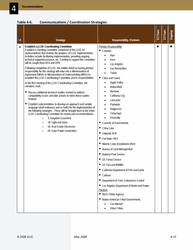
R‐2508 JLUS May 2008 4‐15
4 Recommendations
Table 4‐6. Communications / Coordination Strategies
# Strategy Responsibility / Partners 0-2 Y
ears
3-5 Y
ears
Ongo
ing
9 Establish a JLUS Coordinating Committee Establish a standing committee comprised of the JLUS AC representatives that reviews the progress of JLUS implementation. Activities include facilitating implementation, providing ongoing technical support/assistance, etc. Funding to support this committee will be sought from OEA and OPR.
Following completion of JLUS, the entities listed as having primary responsibility for this strategy will enter into a Memorandum of Agreement (MOA) or Memorandum of Understanding (MOU) to establish the JLUS Coordinating Committee and its responsibilities.
At the first meeting of the JLUS Coordinating Committee, the members shall:
Discuss additional technical studies needed to address compatibility issues and take actions to move these studies forward.
Establish subcommittees to develop an approach and sample language (draft ordinance and so forth) for the implementation of the following strategies. These will be brought back to the entire JLUS Coordinating Committee for review and recommendation.
o 3. Avigation Easement o 18. Light and Glare o 54. Real Estate Disclosure o 59. Solar Power Generation
Primary Responsibility Counties
• Inyo • Kern • Los Angeles • San Bernardino • Tulare
Cities and Towns • Apple Valley • Bakersfield • Barstow • California City • Lancaster • Palmdale • Ridgecrest • Tehachapi • Victorville
Councils of Governments
China Lake
Edwards AFB
Fort Irwin / NTC
Marine Corps Installations West
Bureau of Land Management
National Park Service
US Forest Service
US Fish and Wildlife
California Department of Fish and Game
Caltrans
Department of Toxic Substances Control
Los Angeles Department of Water and Power Partners NGO / Other Agency
Native American Tribal Governments • San Manuel • Other Tribes
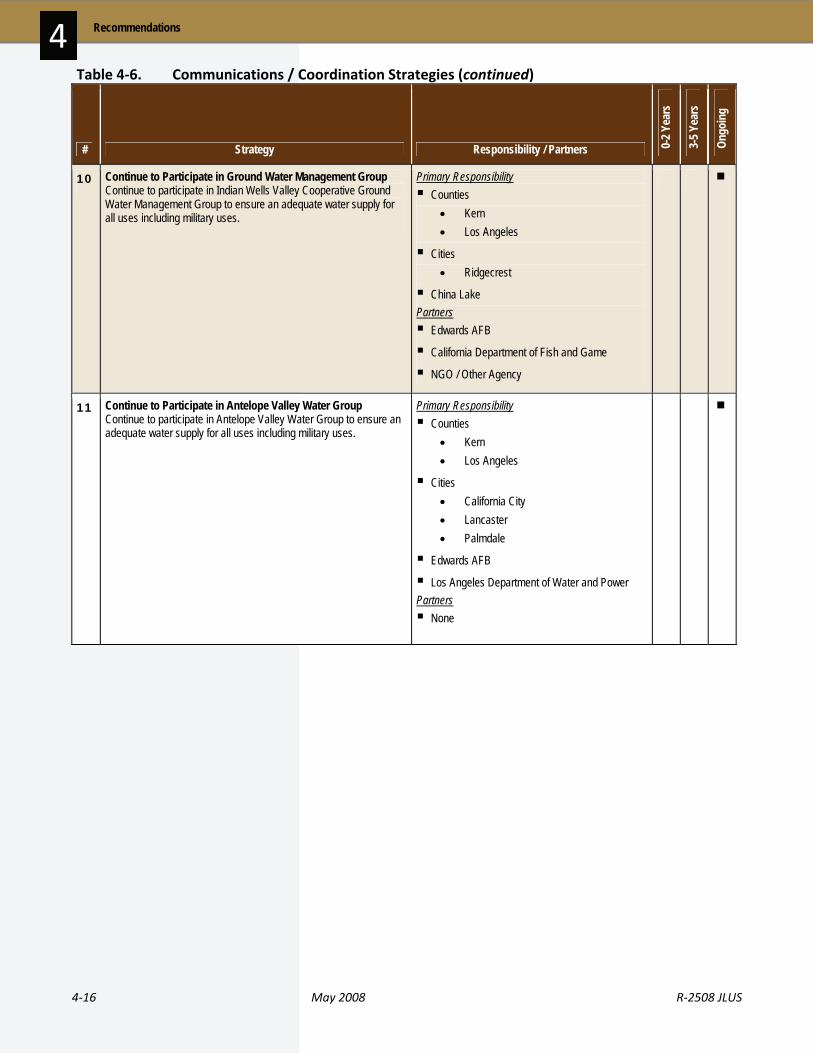
4‐16 May 2008 R‐2508 JLUS
Recommendations 4
# Strategy Responsibility / Partners 0-2 Y
ears
3-5 Y
ears
Ongo
ing
10 Continue to Participate in Ground Water Management Group Continue to participate in Indian Wells Valley Cooperative Ground Water Management Group to ensure an adequate water supply for all uses including military uses.
Primary Responsibility Counties
• Kern • Los Angeles
Cities • Ridgecrest
China Lake Partners Edwards AFB
California Department of Fish and Game
NGO / Other Agency
11 Continue to Participate in Antelope Valley Water Group Continue to participate in Antelope Valley Water Group to ensure an adequate water supply for all uses including military uses.
Primary Responsibility Counties
• Kern • Los Angeles
Cities • California City • Lancaster • Palmdale
Edwards AFB
Los Angeles Department of Water and Power Partners None
Table 4‐6. Communications / Coordination Strategies (continued)

R‐2508 JLUS May 2008 4‐17
4 Recommendations
# Strategy Responsibility / Partners 0-2 Y
ears
3-5 Y
ears
Ongo
ing
12 Refer Development Applications to Military Installations for Review / Comment Integrate military installations within the existing development review process (including the pre-application process). Develop procedures for this review, including project types that should be forwarded and expectations on review timeframes. See also Strategy #21.
Primary Responsibility Counties
• Inyo • Kern • Los Angeles • San Bernardino • Tulare
Cities and Towns • Apple Valley • Bakersfield • Barstow • California City • Lancaster • Palmdale • Ridgecrest • Tehachapi • Victorville
Bureau of Land Management
US Forest Service
Caltrans
Los Angeles Department of Water and Power
NGO / Other Agency Partners China Lake
Edwards AFB
Fort Irwin / NTC
Marine Corps Installations West
Table 4‐6. Communications / Coordination Strategies (continued)

4‐18 May 2008 R‐2508 JLUS
Recommendations 4
# Strategy Responsibility / Partners 0-2 Y
ears
3-5 Y
ears
Ongo
ing
13 Develop an Educational Outreach Program State to develop an educational outreach program for cities and counties regarding SB 1468 and SB 18, and DOD directives and federal regulations including but not limited to DOD Instruction Number 4710.02 for DOD interactions with Federally-Recognized Tribes, US Department of the Interior (DOI) Regulations # 43 CFR 10, Native American Graves Protection and Repatriation (NAGPRA) Regulation, Native American Land Environmental Mitigation Program (NALEMP), and Native American Environmental Tracking System (NAETS).
Primary Responsibility Legislative / State
Partners Counties
• Inyo • Kern • Los Angeles • San Bernardino • Tulare
Cities and Towns • Apple Valley • Bakersfield • Barstow • California City • Lancaster • Palmdale • Ridgecrest • Tehachapi • Victorville
Native American Tribal Governments • San Manuel • Other Tribes
China Lake
Edwards AFB
Fort Irwin / NTC
Marine Corps Installations West
Table 4‐6. Communications / Coordination Strategies (continued)
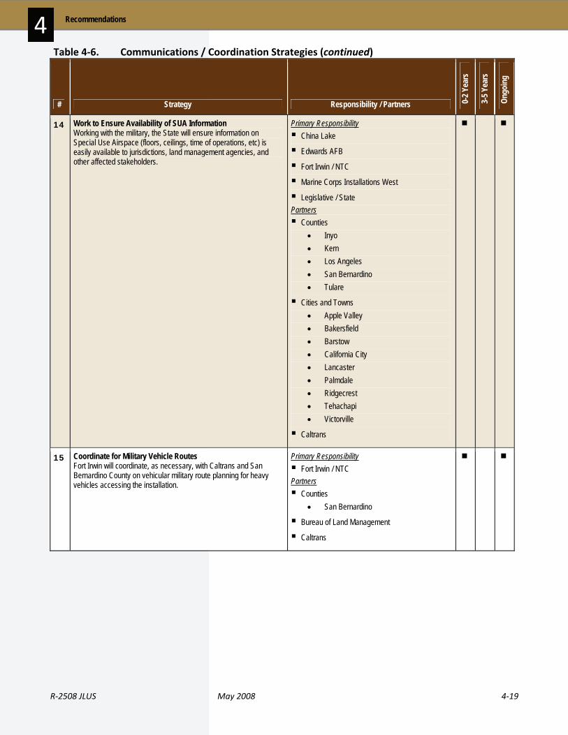
R‐2508 JLUS May 2008 4‐19
4 Recommendations
# Strategy Responsibility / Partners 0-2 Y
ears
3-5 Y
ears
Ongo
ing
14 Work to Ensure Availability of SUA Information Working with the military, the State will ensure information on Special Use Airspace (floors, ceilings, time of operations, etc) is easily available to jurisdictions, land management agencies, and other affected stakeholders.
Primary Responsibility China Lake
Edwards AFB
Fort Irwin / NTC
Marine Corps Installations West
Legislative / State Partners Counties
• Inyo • Kern • Los Angeles • San Bernardino • Tulare
Cities and Towns • Apple Valley • Bakersfield • Barstow • California City • Lancaster • Palmdale • Ridgecrest • Tehachapi • Victorville
Caltrans
15 Coordinate for Military Vehicle Routes Fort Irwin will coordinate, as necessary, with Caltrans and San Bernardino County on vehicular military route planning for heavy vehicles accessing the installation.
Primary Responsibility Fort Irwin / NTC
Partners Counties
• San Bernardino
Bureau of Land Management
Caltrans
Table 4‐6. Communications / Coordination Strategies (continued)
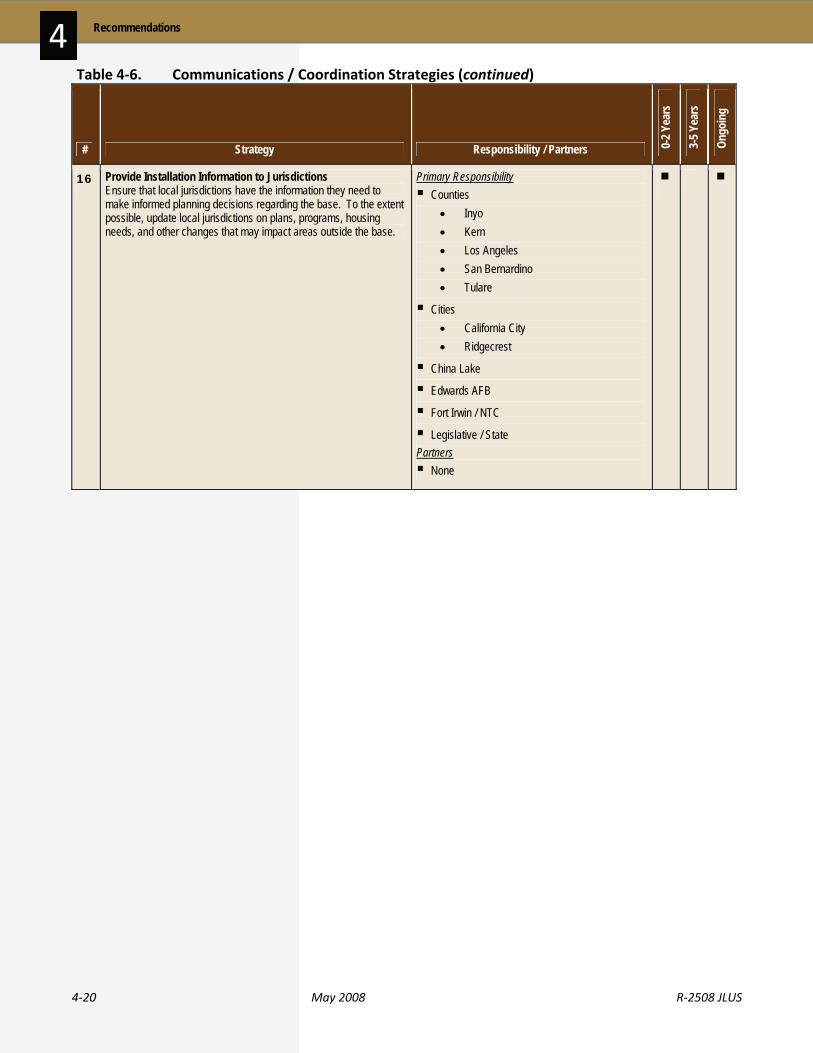
4‐20 May 2008 R‐2508 JLUS
Recommendations 4
# Strategy Responsibility / Partners 0-2 Y
ears
3-5 Y
ears
Ongo
ing
16 Provide Installation Information to Jurisdictions Ensure that local jurisdictions have the information they need to make informed planning decisions regarding the base. To the extent possible, update local jurisdictions on plans, programs, housing needs, and other changes that may impact areas outside the base.
Primary Responsibility Counties
• Inyo • Kern • Los Angeles • San Bernardino • Tulare
Cities • California City • Ridgecrest
China Lake
Edwards AFB
Fort Irwin / NTC
Legislative / State Partners None
Table 4‐6. Communications / Coordination Strategies (continued)
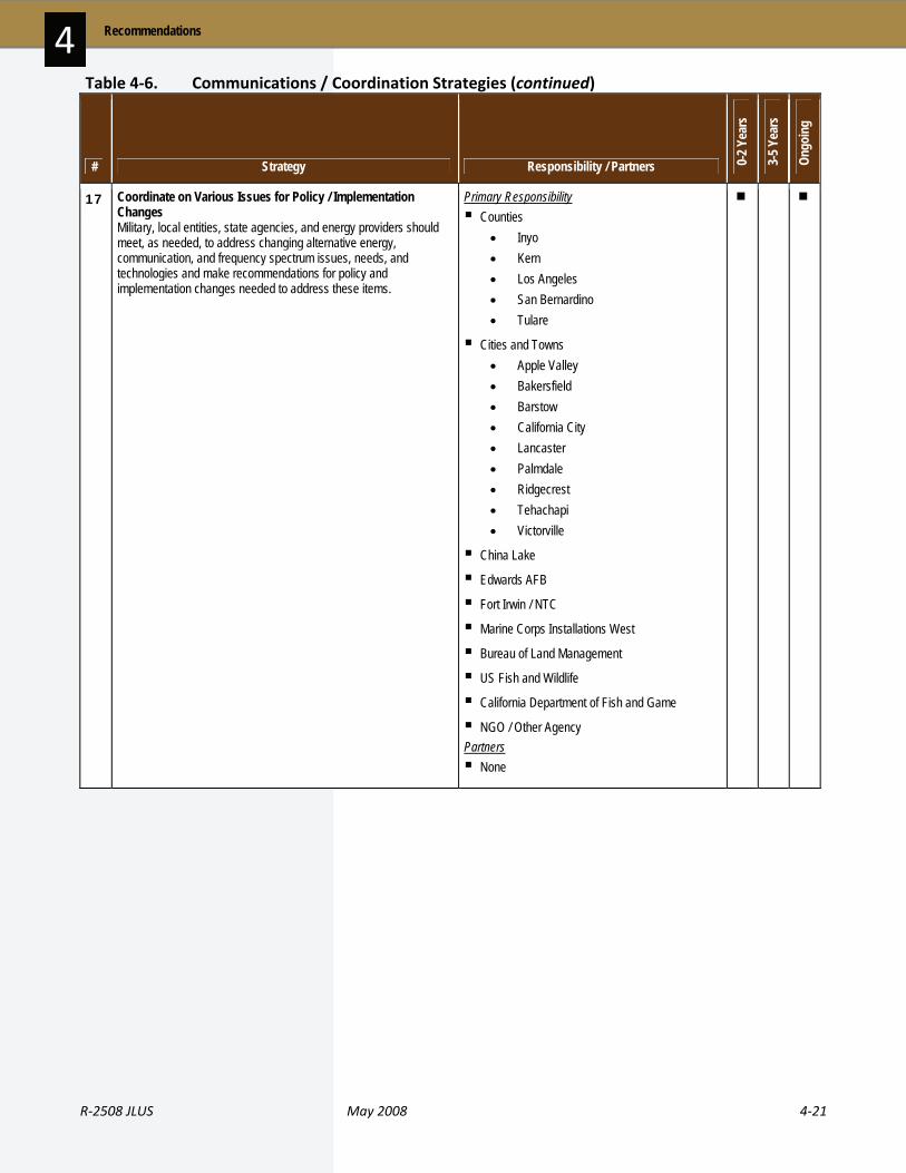
R‐2508 JLUS May 2008 4‐21
4 Recommendations
# Strategy Responsibility / Partners 0-2 Y
ears
3-5 Y
ears
Ongo
ing
17 Coordinate on Various Issues for Policy / Implementation Changes Military, local entities, state agencies, and energy providers should meet, as needed, to address changing alternative energy, communication, and frequency spectrum issues, needs, and technologies and make recommendations for policy and implementation changes needed to address these items.
Primary Responsibility Counties
• Inyo • Kern • Los Angeles • San Bernardino • Tulare
Cities and Towns • Apple Valley • Bakersfield • Barstow • California City • Lancaster • Palmdale • Ridgecrest • Tehachapi • Victorville
China Lake
Edwards AFB
Fort Irwin / NTC
Marine Corps Installations West
Bureau of Land Management
US Fish and Wildlife
California Department of Fish and Game
NGO / Other Agency Partners None
Table 4‐6. Communications / Coordination Strategies (continued)
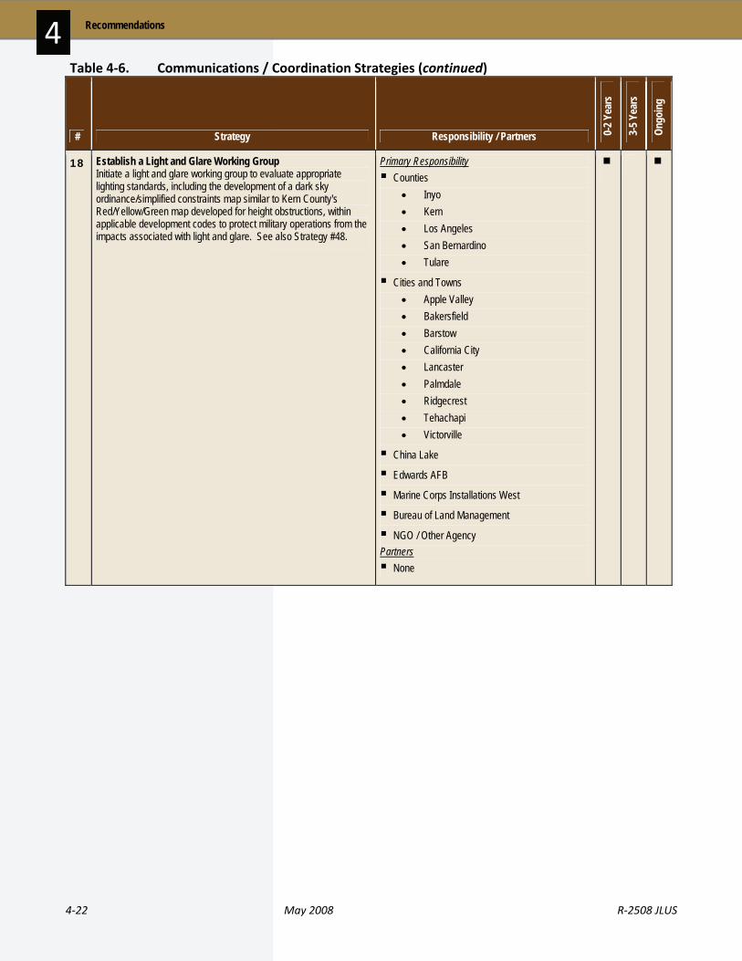
4‐22 May 2008 R‐2508 JLUS
Recommendations 4
# Strategy Responsibility / Partners 0-2 Y
ears
3-5 Y
ears
Ongo
ing
18 Establish a Light and Glare Working Group Initiate a light and glare working group to evaluate appropriate lighting standards, including the development of a dark sky ordinance/simplified constraints map similar to Kern County's Red/Yellow/Green map developed for height obstructions, within applicable development codes to protect military operations from the impacts associated with light and glare. See also Strategy #48.
Primary Responsibility Counties
• Inyo • Kern • Los Angeles • San Bernardino • Tulare
Cities and Towns • Apple Valley • Bakersfield • Barstow • California City • Lancaster • Palmdale • Ridgecrest • Tehachapi • Victorville
China Lake
Edwards AFB
Marine Corps Installations West
Bureau of Land Management
NGO / Other Agency Partners None
Table 4‐6. Communications / Coordination Strategies (continued)

R‐2508 JLUS May 2008 4‐23
4 Recommendations
# Strategy Responsibility / Partners 0-2 Y
ears
3-5 Y
ears
Ongo
ing
19 Encourage Drought Tolerant Landscaping Develop partnerships with water purveyors to encourage the use of drought tolerant landscaping.
Primary Responsibility Counties
• Inyo • Kern • Los Angeles • San Bernardino
Cities and Towns • Apple Valley • Bakersfield • Barstow • California City • Lancaster • Palmdale • Ridgecrest • Tehachapi • Victorville
China Lake
Edwards AFB
Fort Irwin / NTC Partners US Fish and Wildlife
NGO / Other Agency
Table 4‐6. Communications / Coordination Strategies (continued)

4‐24 May 2008 R‐2508 JLUS
Recommendations 4
# Strategy Responsibility / Partners 0-2 Y
ears
3-5 Y
ears
Ongo
ing
20 Establish Procedures to Avoid Frequency Conflicts / Issues Establish procedures for identifying types of proposed projects that involve a source of frequency emissions (including WiFi) within the R-2508 Complex. The local jurisdiction, potentially affected stakeholders, and the Frequency Management Office of the appropriate installation will be contacted for review of their projects to avoid potential frequency conflicts. All coordination between local governments and the affected installation will go through the installation's established single Point of Contact.
Primary Responsibility China Lake
Edwards AFB
Fort Irwin / NTC
Marine Corps Installations West Partners Counties
• Los Angeles • San Bernardino
Cities and Towns • Apple Valley • Bakersfield • Barstow • California City • Lancaster • Ridgecrest • Tehachapi • Victorville
21 Refer Specific BLM Development Applications to Military Installations for Review / Comment BLM to modify application process to ensure early notification to military installations and local communities of specific development requests on managed lands when the initial application is received. BLM will give notification to DOD on the types of projects and locations requiring this level of notification as per recommendation in Strategy #12.
Primary Responsibility Bureau of Land Management
Partners China Lake
Edwards AFB
Fort Irwin / NTC
Table 4‐6. Communications / Coordination Strategies (continued)

R‐2508 JLUS May 2008 4‐25
4 Recommendations
# Strategy Responsibility / Partners 0-2 Y
ears
3-5 Y
ears
Ongo
ing
22 Create Planning Information Clearinghouse OPR to create a clearinghouse of planning information on military sustainability planning.
Primary Responsibility Legislative / State
Partners Counties
• Inyo • Kern • Los Angeles • San Bernardino • Tulare
Cities and Towns • Apple Valley • Bakersfield • Barstow • California City • Lancaster • Palmdale • Ridgecrest • Tehachapi • Victorville
China Lake
Edwards AFB
Fort Irwin / NTC
Marine Corps Installations West
Table 4‐6. Communications / Coordination Strategies (continued)
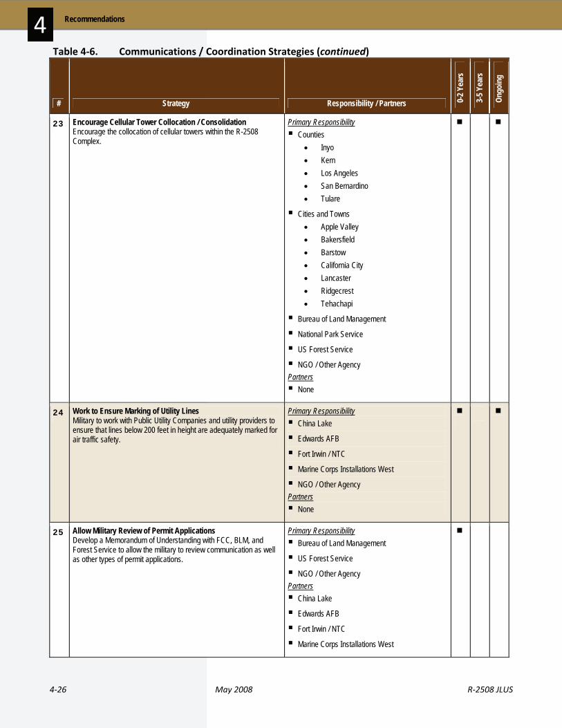
4‐26 May 2008 R‐2508 JLUS
Recommendations 4
# Strategy Responsibility / Partners 0-2 Y
ears
3-5 Y
ears
Ongo
ing
23 Encourage Cellular Tower Collocation / Consolidation Encourage the collocation of cellular towers within the R-2508 Complex.
Primary Responsibility Counties
• Inyo • Kern • Los Angeles • San Bernardino • Tulare
Cities and Towns • Apple Valley • Bakersfield • Barstow • California City • Lancaster • Ridgecrest • Tehachapi
Bureau of Land Management
National Park Service
US Forest Service
NGO / Other Agency Partners None
24 Work to Ensure Marking of Utility Lines Military to work with Public Utility Companies and utility providers to ensure that lines below 200 feet in height are adequately marked for air traffic safety.
Primary Responsibility China Lake
Edwards AFB
Fort Irwin / NTC
Marine Corps Installations West
NGO / Other Agency Partners None
25 Allow Military Review of Permit Applications Develop a Memorandum of Understanding with FCC, BLM, and Forest Service to allow the military to review communication as well as other types of permit applications.
Primary Responsibility Bureau of Land Management
US Forest Service
NGO / Other Agency Partners China Lake
Edwards AFB
Fort Irwin / NTC
Marine Corps Installations West
Table 4‐6. Communications / Coordination Strategies (continued)

R‐2508 JLUS May 2008 4‐27
4 Recommendations
# Strategy Responsibility / Partners 0-2 Y
ears
3-5 Y
ears
Ongo
ing
26 Work to Evaluate Use of Existing Transmission Corridors Work with Public Utilities Commission, BLM, the California Energy Commission, and utility providers to evaluate the opportunity to use existing transmission corridors prior to developing new corridors and, where required, develop new proposed corridors for transmission that do not interfere with military operations.
Primary Responsibility NGO / Other Agency
Partners China Lake
Edwards AFB
Fort Irwin / NTC
Marine Corps Installations West
Bureau of Land Management
27 Review / Amend Controlled Burn Procedures Review existing procedures on the coordination of controlled or open burns within the R-2508 Complex to minimize impacts on mission.
Primary Responsibility China Lake
Edwards AFB
Fort Irwin / NTC
Marine Corps Installations West
Bureau of Land Management
National Park Service
US Forest Service Partners None
28 Investigate Providing Guidance on Tower Location / Height The State will investigate and provide information on when and where a local jurisdiction can control tower placement and height. The State will suggest possible adjustments that can be made to local regulations.
Primary Responsibility Legislative / State
Partners Counties
• Inyo • Kern • Los Angeles • San Bernardino • Tulare
Cities and Towns • Apple Valley • Bakersfield • Barstow • California City • Lancaster • Palmdale • Ridgecrest • Tehachapi • Victorville
Bureau of Land Management
Table 4‐6. Communications / Coordination Strategies (continued)

4‐28 May 2008 R‐2508 JLUS
Recommendations 4
# Strategy Responsibility / Partners 0-2 Y
ears
3-5 Y
ears
Ongo
ing
29 Address Conflicts with High Speed Rail and Highway Projects Coordinate with high speed rail proponents on proposed route and on new highways to address potential conflicts (grade separation, etc.) including High Desert Express (Victorville to Las Vegas) and High Desert Corridor Freeway (Apple Valley to Palmdale).
Primary Responsibility Cities
• Victorville
Councils of Governments
Edwards AFB
Fort Irwin / NTC
Marine Corps Installations West
Bureau of Land Management
US Army Corps of Engineers
Caltrans Partners None
30 Require Planning Coordination with Military Require specific plans, area plans, and other regional plans (either new plans or updates/revisions) in the R-2508 Complex to address a number of compatibility issues involving the military, such as dark skies, water availability and quality, density, cluster development, and other development design issues.
Primary Responsibility Counties
• Inyo • Kern • Los Angeles • San Bernardino • Tulare
Cities and Towns • Apple Valley • Bakersfield • Barstow • California City • Lancaster • Palmdale • Ridgecrest • Tehachapi
Partners None
Table 4‐6. Communications / Coordination Strategies (continued)

R‐2508 JLUS May 2008 4‐29
4 Recommendations
# Strategy Responsibility / Partners 0-2 Y
ears
3-5 Y
ears
Ongo
ing
31 Partner for BLM Lands BLM to partner with counties, cities, Native American tribal governments and military installations within the R-2508 Complex for the sustainable use of BLM lands. Proposed actions include the identification and assessment of BLM land within identified areas of interest, identification of designated "unclassified" lands that may have a negative impact on military missions, and identification of areas to use for BLM land transfers.
Primary Responsibility Cities and Towns
• Apple Valley • Bakersfield • Barstow • California City • Lancaster • Palmdale • Ridgecrest • Tehachapi
China Lake
Edwards AFB
Fort Irwin / NTC
Marine Corps Installations West
Bureau of Land Management
NGO / Other Agency Partners Counties
• Inyo • Kern • Los Angeles • San Bernardino • Tulare
National Park Service
Native American Tribal Governments • San Manuel • Other Tribes
US Fish and Wildlife
US Forest Service
California Department of Fish and Game
32 Review Operational Guidelines for the Controlled Firing Area Military to review operational guidelines for the Controlled Firing Area (CFA), which overlies the BLM Spangler Hills Recreation Area (SHRA), and identify specific issues to address through continued dialogue with BLM. The objective of this coordination is to ensure the long-term sustainability of both the Navy's CFA operational capabilities and BLM's management goals as defined in California Desert Conservation Area (CDCA) Plan and local BLM management plan for the SHRA.
Primary Responsibility China Lake
Bureau of Land Management Partners Counties
• Kern • San Bernardino
Table 4‐6. Communications / Coordination Strategies (continued)
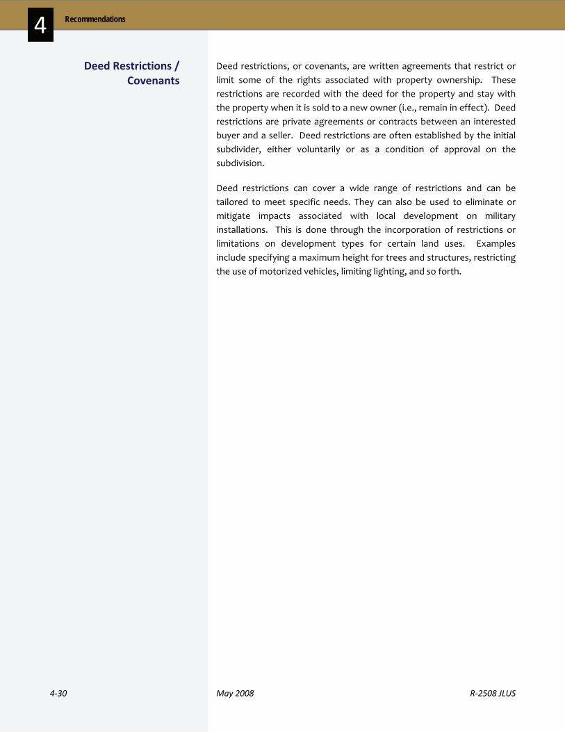
4‐30 May 2008 R‐2508 JLUS
Recommendations 4 Deed restrictions, or covenants, are written agreements that restrict or limit some of the rights associated with property ownership. These restrictions are recorded with the deed for the property and stay with the property when it is sold to a new owner (i.e., remain in effect). Deed restrictions are private agreements or contracts between an interested buyer and a seller. Deed restrictions are often established by the initial subdivider, either voluntarily or as a condition of approval on the subdivision.
Deed restrictions can cover a wide range of restrictions and can be tailored to meet specific needs. They can also be used to eliminate or mitigate impacts associated with local development on military installations. This is done through the incorporation of restrictions or limitations on development types for certain land uses. Examples include specifying a maximum height for trees and structures, restricting the use of motorized vehicles, limiting lighting, and so forth.
Deed Restrictions / Covenants
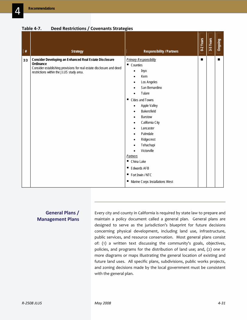
R‐2508 JLUS May 2008 4‐31
4 Recommendations
Table 4‐7. Deed Restrictions / Covenants Strategies
# Strategy Responsibility / Partners 0-2 Y
ears
3-5 Y
ears
Ongo
ing
33 Consider Developing an Enhanced Real Estate Disclosure Ordinance Consider establishing provisions for real estate disclosure and deed restrictions within the JLUS study area.
Primary Responsibility Counties
• Inyo • Kern • Los Angeles • San Bernardino • Tulare
Cities and Towns • Apple Valley • Bakersfield • Barstow • California City • Lancaster • Palmdale • Ridgecrest • Tehachapi • Victorville
Partners China Lake
Edwards AFB
Fort Irwin / NTC
Marine Corps Installations West
Every city and county in California is required by state law to prepare and maintain a policy document called a general plan. General plans are designed to serve as the jurisdiction’s blueprint for future decisions concerning physical development, including land use, infrastructure, public services, and resource conservation. Most general plans consist of: (1) a written text discussing the community's goals, objectives, policies, and programs for the distribution of land use; and, (2) one or more diagrams or maps illustrating the general location of existing and future land uses. All specific plans, subdivisions, public works projects, and zoning decisions made by the local government must be consistent with the general plan.
General Plans / Management Plans

4‐32 May 2008 R‐2508 JLUS
Recommendations 4 A general plan typically has three defining features:
General. As the name implies, a general plan provides general policy guidance that will direct community land use and resource decisions
Comprehensive. A general plan covers a wide range of social, economic, infrastructure, and natural resource factors as they relate to land use and development. These include topics such as land use, housing, circulation, utilities, public services, recreation, agriculture, biological resources, noise, safety, and other issues that are relevant to the jurisdiction
Long‐range. General plans provide guidance on reaching an envisioned future. To fulfill this vision, the general plan will include policies and actions that address both immediate and long‐term needs. Most general plans look 20 years into the future
The primary purposes of a general plan are to:
Identify the community’s land use, circulation, environmental, economic, and social goals and policies as they relate to future development in the community
Provide a basis for local government decision making, including decisions on development approvals
Provide citizens with opportunities to participate in the planning and decision making processes of their communities
Inform citizens, developers, decision makers, and other cities and counties of the policies that guide development within a particular community
Senate Bill (SB) 1468 (Knight, Chapter 971, Statutes of 2002) is part of a state policy package to promote the development of a partnership between communities and the military that allows for collaboration on land use compatibility issues. OPR encourages local jurisdictions near military installations, and under military training routes or restricted airspace, to incorporate the above items into their general plans. However, local governments are not currently required by law to include the SB 1468 military compatibility issues in their general plans. The bill specifies that if a funding agreement is reached between OPR and the military to support these efforts, the inclusion of military compatibility issues in a general plan will become mandatory.

R‐2508 JLUS May 2008 4‐33
4 Recommendations
Table 4‐8. General Plans / Management Plans Strategies
# Strategy Responsibility / Partners 0-2 Y
ears
3-5 Y
ears
Ongo
ing
34 Review of Management Plans for Military Compatibility Federal and state agencies to review their management plans to determine compatibility with military operations.
Primary Responsibility Bureau of Land Management
National Park Service
US Forest Service
Caltrans Partners China Lake
Edwards AFB
Fort Irwin / NTC
Marine Corps Installations West
35 Ensure Water Impacts in Plan Development / Updates Ensure general plan updates and specific plans consider impacts to water availability and quality via policy or other development regulations.
Primary Responsibility Counties
• Inyo • Kern • Los Angeles • San Bernardino
Cities and Towns • Apple Valley • Bakersfield • Barstow • California City • Lancaster • Palmdale • Ridgecrest • Tehachapi • Victorville
Partners None

4‐34 May 2008 R‐2508 JLUS
Recommendations 4
# Strategy Responsibility / Partners 0-2 Y
ears
3-5 Y
ears
Ongo
ing
36 Involve Military in General Plan Update Process Ensure that the military is aware and encouraged to be involved early in the general plan process for major updates and amendments. For jurisdictions outside the R-2508 Complex, early notification to the military is encouraged.
Primary Responsibility Counties
• Inyo • Kern • Los Angeles • San Bernardino • Tulare
Cities and Towns • Apple Valley • Bakersfield • Barstow • California City • Lancaster • Palmdale • Ridgecrest • Tehachapi • Victorville
Bureau of Land Management
US Forest Service
California Department of Fish and Game
Caltrans
NGO / Other Agency Partners China Lake
Edwards AFB
Fort Irwin / NTC
Marine Corps Installations West
37 Evaluate Willow Springs Specific Plan Uses Evaluate Willow Springs Specific Plan for other compatible uses besides residential, commercial, and industrial.
Primary Responsibility Counties
• Kern
NGO / Other Agency Partners Edwards AFB
Table 4‐8. General Plans / Management Plans Strategies (continued)

R‐2508 JLUS May 2008 4‐35
4 Recommendations
# Strategy Responsibility / Partners 0-2 Y
ears
3-5 Y
ears
Ongo
ing
38 Consider Developing Methods to Address Frequency Spectrum Conflicts Consider developing general plan policies or other appropriate implementation methods in consultation with the military that are designed to reduce or eliminate frequency spectrum conflict issues that are associated with discretionary approvals.
Primary Responsibility Counties
• Inyo • Kern • Los Angeles • San Bernardino • Tulare
Cities and Towns • Apple Valley • Bakersfield • Barstow • California City • Lancaster • Palmdale • Ridgecrest • Tehachapi • Victorville
NGO / Other Agency Partners China Lake
Edwards AFB
Fort Irwin / NTC
Marine Corps Installations West
39 Evaluate Rosamond Land Use Changes for Traffic Impacts Evaluate land use changes (general plan amendments) in Rosamond area relative to traffic impacts (e.g. locate to west of Highway 14, mitigation fees for expansion).
Primary Responsibility Counties
• Kern Partners None
40 Consider Evaluating Urban / Rural Interface Consider an urban / rural interface between Mahan and Jack Ranch Road in Ridgecrest / Kern County.
Primary Responsibility Counties
• Kern
Cities • Ridgecrest
China Lake
Bureau of Land Management Partners None
Table 4‐8. General Plans / Management Plans Strategies (continued)
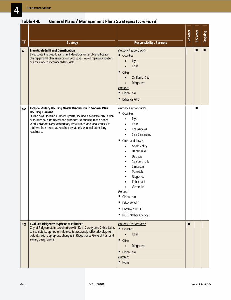
4‐36 May 2008 R‐2508 JLUS
Recommendations 4
# Strategy Responsibility / Partners 0-2 Y
ears
3-5 Y
ears
Ongo
ing
41 Investigate Infill and Densification Investigate the possibility for infill development and densification during general plan amendment processes, avoiding intensification of areas where incompatibility exists.
Primary Responsibility Counties
• Inyo • Kern
Cities • California City • Ridgecrest
Partners China Lake
Edwards AFB
42 Include Military Housing Needs Discussion in General Plan Housing Element During next Housing Element update, include a separate discussion of military housing needs and programs to address these needs. Work collaboratively with military installations and local entities to address their needs as required by state law to look at military readiness.
Primary Responsibility Counties
• Inyo • Kern • Los Angeles • San Bernardino
Cities and Towns • Apple Valley • Bakersfield • Barstow • California City • Lancaster • Palmdale • Ridgecrest • Tehachapi • Victorville
Partners China Lake
Edwards AFB
Fort Irwin / NTC
NGO / Other Agency
43 Evaluate Ridgecrest Sphere of Influence City of Ridgecrest, in coordination with Kern County and China Lake, to evaluate its sphere of influence to accurately reflect development potential with appropriate changes in Ridgecrest's General Plan and zoning designations.
Primary Responsibility Counties
• Kern
Cities • Ridgecrest
China Lake Partners None
Table 4‐8. General Plans / Management Plans Strategies (continued)

R‐2508 JLUS May 2008 4‐37
4 Recommendations
# Strategy Responsibility / Partners 0-2 Y
ears
3-5 Y
ears
Ongo
ing
44 Evaluate California City Sphere of Influence The City of California City, in coordination with Kern County and Edwards AFB, to evaluate its sphere of influence to accurately reflect development potential with appropriate changes in California City's General Plan and zoning designations.
Primary Responsibility Counties
• Kern
Cities • California City
Edwards AFB Partners None
45 Encourage Trip Reduction Techniques Encourage the evaluation of trip reduction techniques that can be used to reduce congestion. Consider incentives program to aid in implementation.
Primary Responsibility Counties
• Kern • Los Angeles
Cities • California City • Lancaster • Palmdale
Edwards AFB
NGO / Other Agency Partners None
The California Natural Community Conservation Planning Act and the Federal Endangered Species Act allow for the development of Natural Community Conservation Plans (NCCPs) and Habitat Conservation Plans (HCPs). An NCCP identifies and provides for the regional or areawide protection of plants, animals, and their habitats, while allowing compatible and appropriate economic activity.
Incidental take permits help landowners legally proceed with activities that might otherwise result in illegal impacts to a listed species. An HCP is a document that supports an incidental take permit application pursuant to section 10(a)(1)(B) of the Federal Endangered Species Act. HCPs are an evolving tool. Initially designed to address individual projects, HCPs are currently more likely to be broad‐based plans covering a large area. The geographically broader HCP is used as the basis for an incidental take permit for any project within the boundaries of the HCP. Regardless of size, an HCP should include measures that, when
Habitat Conservation
Table 4‐8. General Plans / Management Plans Strategies (continued)

4‐38 May 2008 R‐2508 JLUS
Recommendations 4 implemented, minimize and mitigate impacts to the designated species to the maximum extent possible, and the means by which these efforts will be funded.
The primary objective of the NCCP and HCP programs is to conserve natural communities at the ecosystem level while accommodating compatible land use. The programs seek to anticipate and prevent the controversies and gridlock that can be caused by species' listings. Instead, they focus on the long‐term stability of wildlife and plant communities. The programs also include key stakeholders in the development process for the plan.
Table 4‐9. Habitat Conservation Strategies
# Strategy Responsibility / Partners 0-2 Y
ears
3-5 Y
ears
Ongo
ing
46 Consider Regional Habitat Conservation Plan Consider the West Mojave Habitat Conservation Plan as the regional habitat conservation plan.
Primary Responsibility Counties
• Inyo • Kern • Los Angeles • San Bernardino
Cities and Towns • Apple Valley • Barstow • California City • Lancaster • Palmdale • Ridgecrest • Victorville
Partners China Lake
Edwards AFB
Fort Irwin / NTC
Bureau of Land Management
US Fish and Wildlife
US Forest Service
California Department of Fish and Game
NGO / Other Agency

R‐2508 JLUS May 2008 4‐39
4 Recommendations
A variety of legislative initiatives at the federal, state, and local levels can be used to enhance the sustainability of military installations and ranges. These initiatives aim to mitigate incompatible land uses or impacts of military operations on protected lands.
Table 4‐10. Legislative Initiatives Strategies
# Strategy Responsibility / Partners 0-2 Y
ears
3-5 Y
ears
Ongo
ing
47 Protect Military Missions with Wilderness Legislation Include language that protects current and future military missions as part of any new wilderness legislation proposed within the R-2508 Complex.
Primary Responsibility Legislative / State and Federal
Partners China Lake
Edwards AFB
Fort Irwin / NTC
Marine Corps Installations West
Bureau of Land Management
National Park Service
US Forest Service
Light pollution is defined as any adverse effect of natural light, including sky glow, glare, light trespass, light clutter, decreased visibility at night, and energy waste. Light pollution and excessive glare can have negative impacts on military operations in the R‐2508 Complex, as well as on the natural environment. Funding for military installations to implement light and glare controls may be found through the installation’s capital improvements program, operations and maintenance program, or other federal sources.
Light and Glare Controls
Legislative Initiatives

4‐40 May 2008 R‐2508 JLUS
Recommendations 4 Table 4‐11. Light and Glare Controls Strategies
# Strategy Responsibility / Partners 0-2 Y
ears
3-5 Y
ears
Ongo
ing
48 Determine Dark Sky Funding Sources For portions of the R-2508 area identified by the military as critical to dark sky initiatives, evaluate funding sources available to assist in lighting retrofit programs. See also Strategy # 18.
Primary Responsibility China Lake
Edwards AFB
Fort Irwin / NTC
Marine Corps Installations West Partners Counties
• Inyo • Kern • Los Angeles • San Bernardino • Tulare
Cities • Barstow • California City • Lancaster • Ridgecrest • Tehachapi
NGO / Other Agency
A memorandum of understanding is a contract between two or more government entities. The governing bodies of the participating public agencies must take appropriate legal actions, often adoption of an ordinance or, resolution, before such agreements become effective. These agreements are also known as Joint Powers Agreements or Interlocal Agreements.
California Government Code, Section 6500 et seq. allows public agencies to enter into joint agreements. The definition of public agency includes, but is not limited to, the federal government or a federal agency, the state or any state department or agency, a county, city, county board of education or school superintendent, public corporation, or public district.
The purpose of an MOU is to establish a formal framework for coordination and cooperation. These agreements may also assign roles and responsibilities for all of the agreement’s signatories. MOUs generally promote:
Memorandum of Understanding (MOU)

R‐2508 JLUS May 2008 4‐41
4 Recommendations
Coordination and collaboration by sharing information on specific community development proposals, such as rezonings and subdivisions
Joint communication between participating jurisdictions and the military ensuring that residents, developers, businesses, and local decision makers have adequate information about military operations, possible impacts on surrounding lands, procedures to submit comments, and any additional local measures to promote land use compatibility around installations
Formal agreement on land use planning activities, such as implementation of a Joint Land Use Study (JLUS)
Table 4‐12. MOU Strategies
# Strategy Responsibility / Partners 0-2 Y
ears
3-5 Y
ears
Ongo
ing
49 Evaluate Implementation of Military Emission Reduction System Evaluate the viability of an emission reduction credit system between the three military installations in the R-2508 Complex through the use of a cooperative agreement (MOU).
Primary Responsibility China Lake
Edwards AFB
Fort Irwin / NTC Partners None
50 Coordinate Military Ordnance Use and Location Develop a Memorandum of Understanding between Edwards AFB, BLM, San Bernardino County, and Los Angeles County to coordinate on the frequency and location of ordnance activity adjacent to base boundary.
Primary Responsibility Counties
• Los Angeles • San Bernardino
Edwards AFB
Bureau of Land Management Partners None
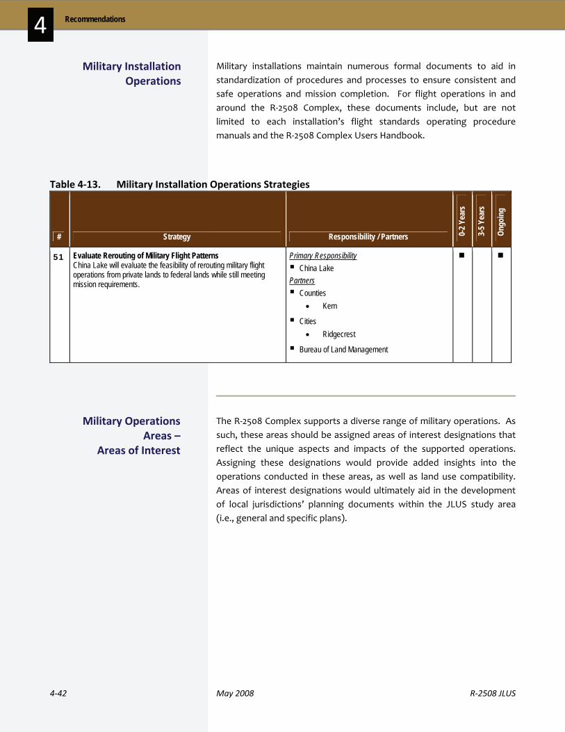
4‐42 May 2008 R‐2508 JLUS
Recommendations 4 Military installations maintain numerous formal documents to aid in standardization of procedures and processes to ensure consistent and safe operations and mission completion. For flight operations in and around the R‐2508 Complex, these documents include, but are not limited to each installation’s flight standards operating procedure manuals and the R‐2508 Complex Users Handbook.
Table 4‐13. Military Installation Operations Strategies
# Strategy Responsibility / Partners 0-2 Y
ears
3-5 Y
ears
Ongo
ing
51 Evaluate Rerouting of Military Flight Patterns China Lake will evaluate the feasibility of rerouting military flight operations from private lands to federal lands while still meeting mission requirements.
Primary Responsibility China Lake
Partners Counties
• Kern
Cities • Ridgecrest
Bureau of Land Management
The R‐2508 Complex supports a diverse range of military operations. As such, these areas should be assigned areas of interest designations that reflect the unique aspects and impacts of the supported operations. Assigning these designations would provide added insights into the operations conducted in these areas, as well as land use compatibility. Areas of interest designations would ultimately aid in the development of local jurisdictions’ planning documents within the JLUS study area (i.e., general and specific plans).
Military Installation Operations
Military Operations Areas –
Areas of Interest

R‐2508 JLUS May 2008 4‐43
4 Recommendations
Table 4‐14. Military Operations Areas Strategies
# Strategy Responsibility / Partners 0-2 Y
ears
3-5 Y
ears
Ongo
ing
52 Develop Area of Interest Designations for Operations Areas Develop an area of interest designation for particular operation areas (such as CORDS Road, BMSSC, North Spin Area, PIRA buffer area). The areas of interest designation would be considered for use in general and/or specific plan documents, as well as other planning documents (ALUCP or Zoning Ordinance) to identify areas of military operations that need a site-specific review for compatibility. A menu of compatibility tools will be developed by counties, cities, Native American tribal governments, and the military to provide options to address impacts such as noise, safety considerations, and vibration. The goal of the tools will be to encourage creative solutions for property owners in assessing land use of their property where military operations occur to promote mutual sustainability and encourage dialogue. The tools will provide a range of options that include potential actions both by the DOD and local government that would sustain property rights and the military mission.
Primary Responsibility Counties
• Inyo • Kern • Los Angeles • San Bernardino • Tulare
Cities and Towns • Apple Valley • Bakersfield • Barstow • California City • Lancaster • Palmdale • Ridgecrest • Tehachapi • Victorville
China Lake
Edwards AFB
Fort Irwin / NTC
Marine Corps Installations West Partners Native American Tribal Governments
• San Manuel • Other Tribes
US Fish and Wildlife
California Department of Fish and Game
Prior to the transfer of real property to a new owner, California law requires sellers and their agents to disclose all actual known facts related to the condition of the property (California Civil Code, Section 1102). This disclosure should include noise or other proximity impacts associated with property located near a military installation or operations area.
The purpose of real estate disclosure is to protect the seller, buyer, and sales agent from potential litigation resulting from specified conditions (i.e., hazard areas, existing easements). Real estate disclosure can be
Real Estate Disclosure

4‐44 May 2008 R‐2508 JLUS
Recommendations 4 used to inform potential buyers and renters of the possible affects from nearby military installations. This disclosure can be one of the most practical and cost effective land use compatibility tools. California has enabled local governments, working in cooperation with the real estate industry, to establish noise disclosure by regulation or voluntary initiation (California Civil Code, Section 1102).
Table 4‐15. Real Estate Disclosure Strategies
# Strategy Responsibility / Partners 0-2 Y
ears
3-5 Y
ears
Ongo
ing
53 Provide UXO Information Disseminate information on Unexploded Ordnance (UXO) areas that may exist off installation property and provide communication outreach to affected stakeholders including the following: US Army Corps of Engineers' Formerly Used Defense Sites (FUDS) program, Munitions Response Committee (MRC), and California Department of Toxic Substances Control.
Primary Responsibility US Army Corps of Engineers
Partners Counties
• Inyo • Kern • Los Angeles • San Bernardino • Tulare
Cities and Towns • Apple Valley • Bakersfield • Barstow • California City • Lancaster • Palmdale • Ridgecrest • Tehachapi • Victorville
China Lake
Edwards AFB
Fort Irwin / NTC
Marine Corps Installations West
Bureau of Land Management
National Park Service
US Forest Service
Department of Toxic Substances Control

R‐2508 JLUS May 2008 4‐45
4 Recommendations
# Strategy Responsibility / Partners 0-2 Y
ears
3-5 Y
ears
Ongo
ing
54 Develop / Modify Disclosure Notices for Military Operations Work with California Department of Real Estate, local real estate representatives, and military representatives to develop and implement adequate language for inclusion within disclosure notices pertaining to noise and safety considerations associated with military missions, where appropriate.
Primary Responsibility Counties
• Inyo • Kern • Los Angeles • San Bernardino • Tulare
Cities and Towns • Apple Valley • Bakersfield • Barstow • California City • Lancaster • Palmdale • Ridgecrest • Tehachapi • Victorville
NGO / Other Agency Partners China Lake
Edwards AFB
Fort Irwin / NTC
Marine Corps Installations West
Zoning
Zoning is the division of a jurisdiction into districts (zones) within which permissible uses are prescribed and restrictions on building height, bulk, layout, and other requirements are defined.
The primary purpose of zoning is the protection of public health, safety, and welfare. Refining this goal further, zoning provides opportunities for the implementation of regulations supporting land use compatibility, as shown in the following examples.
Zoning / Subdivision / Other Local Regulations
Table 4‐15. Real Estate Disclosure Strategies (continued)

4‐46 May 2008 R‐2508 JLUS
Recommendations 4 Protection against:
o Physical danger, particularly safety considerations for properties in proximity to military ranges or within military flight areas
o Nuisances associated with military operations, such as noise, vibration, air emissions, etc.
o Heavy traffic flows or truck routes in residential areas
o Aesthetic nuisances impacting military installations
o Psychological nuisances, such as perceived and actual dangers associated with military operations
o Light and glare, air emissions, and loss of privacy
Provision of open space and agricultural preservation
Zoning and the general plan are inexorably tied to each other. Policies recommended within the general plan should be reflected within the zoning ordinance or development code
Zoning ordinances requiring rigid separation of uses or inflexible provisions can make creative solutions to land use compatibility, such as cluster development, difficult or impossible
When designating military compatible use districts, the ordinance should recognize that the local community has no regulatory control over development or activities on federal property
Subdivisions
Land cannot be divided in California without local government approval. Dividing land for sale, lease or financing is regulated by local ordinances based on the State Subdivision Map Act (commencing with Government Code, Section 66410). The local general plan, zoning, subdivision, and other ordinances govern the design of the subdivision, the size of its lots, and the types of required improvements, such as street construction, sewer lines, and drainage facilities.
There are two types of subdivisions:
Parcel maps, which create fewer than five new lots
Tentative subdivision maps (also called tract maps), which create five or more new lots
Applications for both types of subdivisions must be submitted to the local government for consideration.
Subdivision ordinances set forth the minimum requirements deemed necessary to protect the health, safety, and welfare of the public. More specifically, the subdivision ordinances are designed to accomplish the following initiatives.

R‐2508 JLUS May 2008 4‐47
4 Recommendations
Assure that effective protection is given to the natural resources of the community, especially ground water and surface waters
Encourage well‐planned subdivisions through the establishment of adequate design standards
Facilitate adequate provisions for transportation and other public facilities
Secure the rights of the public with respect to public lands and waters
Improve land records by the establishment of standards for surveys and plats
Safeguard the interests of the public, the homeowner, the subdivider, and units of local government
Prevent, where possible, excessive governmental operating and maintenance costs
Table 4‐16. Zoning / Subdivision / Other Local Regulations Strategies
# Strategy Responsibility / Partners 0-2 Y
ears
3-5 Y
ears
Ongo
ing
55 Use Subdivision Regulations to Minimize Impacts Encourage subdivision regulations to allow for clustering of units to minimize areas affected by military operations.
Primary Responsibility Counties
• Los Angeles • San Bernardino
Cities and Towns • Apple Valley • Barstow • California City
Partners None

4‐48 May 2008 R‐2508 JLUS
Recommendations 4
# Strategy Responsibility / Partners 0-2 Y
ears
3-5 Y
ears
Ongo
ing
56 Determine Density Limitations Needs Reexamine the need for density limitations within flight corridors in consultation with the military.
Primary Responsibility Counties
• Inyo • Kern • Los Angeles • San Bernardino
Cities and Towns • Apple Valley • Barstow • California City • Ridgecrest • Tehachapi • Victorville
Partners China Lake
Edwards AFB
Fort Irwin / NTC
Marine Corps Installations West
57 Consider Evaluating Use of China Lake Military Overlay District Consider developing a military overlay district to protect China Lake operational areas.
Primary Responsibility Counties
• Kern
Cities • Ridgecrest
China Lake Partners None
Table 4‐16. Zoning / Subdivision / Other Regulations Strategies (continued)
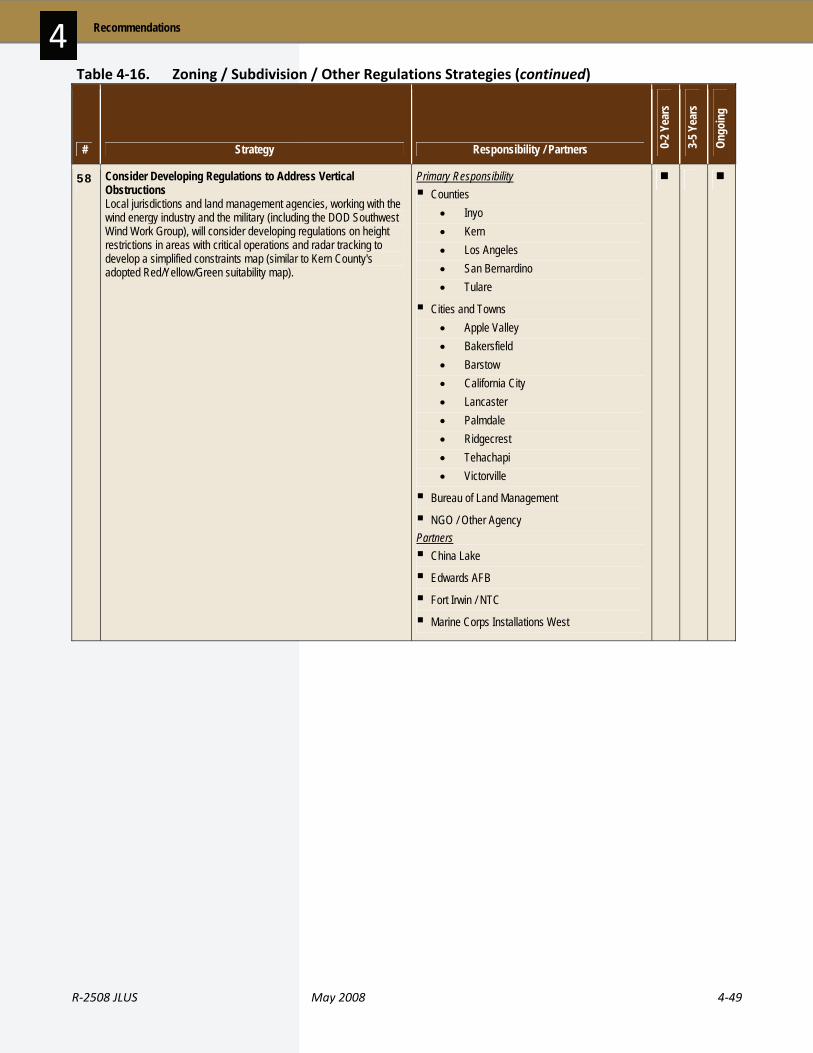
R‐2508 JLUS May 2008 4‐49
4 Recommendations
# Strategy Responsibility / Partners 0-2 Y
ears
3-5 Y
ears
Ongo
ing
58 Consider Developing Regulations to Address Vertical Obstructions Local jurisdictions and land management agencies, working with the wind energy industry and the military (including the DOD Southwest Wind Work Group), will consider developing regulations on height restrictions in areas with critical operations and radar tracking to develop a simplified constraints map (similar to Kern County's adopted Red/Yellow/Green suitability map).
Primary Responsibility Counties
• Inyo • Kern • Los Angeles • San Bernardino • Tulare
Cities and Towns • Apple Valley • Bakersfield • Barstow • California City • Lancaster • Palmdale • Ridgecrest • Tehachapi • Victorville
Bureau of Land Management
NGO / Other Agency Partners China Lake
Edwards AFB
Fort Irwin / NTC
Marine Corps Installations West
Table 4‐16. Zoning / Subdivision / Other Regulations Strategies (continued)
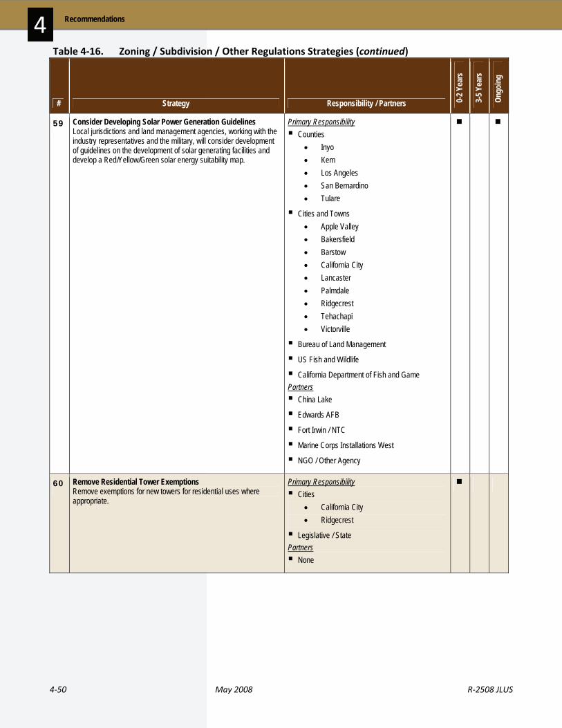
4‐50 May 2008 R‐2508 JLUS
Recommendations 4
# Strategy Responsibility / Partners 0-2 Y
ears
3-5 Y
ears
Ongo
ing
59 Consider Developing Solar Power Generation Guidelines Local jurisdictions and land management agencies, working with the industry representatives and the military, will consider development of guidelines on the development of solar generating facilities and develop a Red/Yellow/Green solar energy suitability map.
Primary Responsibility Counties
• Inyo • Kern • Los Angeles • San Bernardino • Tulare
Cities and Towns • Apple Valley • Bakersfield • Barstow • California City • Lancaster • Palmdale • Ridgecrest • Tehachapi • Victorville
Bureau of Land Management
US Fish and Wildlife
California Department of Fish and Game Partners China Lake
Edwards AFB
Fort Irwin / NTC
Marine Corps Installations West
NGO / Other Agency
60 Remove Residential Tower Exemptions Remove exemptions for new towers for residential uses where appropriate.
Primary Responsibility Cities
• California City • Ridgecrest
Legislative / State Partners None
Table 4‐16. Zoning / Subdivision / Other Regulations Strategies (continued)

R‐2508 JLUS May 2008 4‐51
4 Recommendations
# Strategy Responsibility / Partners 0-2 Y
ears
3-5 Y
ears
Ongo
ing
61 Identify and Mitigate Dust Constraints The military will identify areas where dust impacts operations and discuss with the Air District and local jurisdictions possible mitigations to reduce impacts.
Primary Responsibility Cities
• Bakersfield • Barstow • California City • Lancaster • Palmdale • Tehachapi
Bureau of Land Management
National Park Service
US Forest Service
Caltrans
Los Angeles Department of Water and Power Partners China Lake
Edwards AFB
Fort Irwin / NTC
Marine Corps Installations West
California Department of Fish and Game
4 . 3 S t r a t e g i e s S u m m a r i z e d b y A g e n c y a n d T i m e l i n e
The following section provides a set of summary tables designed to allow readers to look up applicable strategies based on the following sorting criteria:
Responsible or partner jurisdiction, organization or agency (Table 4‐17)
Implementation timeline (Table 4‐18)
Each table lists the strategy number and title. Details on each strategy can be found in Tables 4‐2 through 4‐16, presented earlier in this section.
Table 4‐16. Zoning / Subdivision / Other Regulations Strategies (continued)

4‐52 May 2008 R‐2508 JLUS
Recommendations 4 Table 4‐17. Strategies by Agency
Inyo County
As a Responsible Party As a Partner
Airport Land Use Compatibility Strategies 2. Update ALUCP to Reflect Military Air Facilities and Airspace Avigation Easements Strategies 3. Consider Developing / Updating an Avigation Easement Program Communications / Coordination Strategies 9. Establish a JLUS Coordinating Committee 12. Refer Development Applications to Military Installations for Review /
Comment 16. Provide Installation Information to Jurisdictions 17. Coordinate on Various Issues for Policy / Implementation Changes 18. Establish a Light and Glare Working Group 19. Encourage Drought Tolerant Landscaping 23. Encourage Cellular Tower Collocation / Consolidation 30. Require Planning Coordination with Military Deed Restrictions / Covenants Strategies 33. Consider Developing an Enhanced Real Estate Disclosure Ordinance General Plans / Management Plans Strategies 35. Ensure Water Impacts in Plan Development / Updates 36. Involve Military in General Plan Update Process 38. Consider Developing Methods to Address Frequency Spectrum
Conflicts 41. Investigate Infill and Densification 42. Include Military Housing Needs Discussion in General Plan Housing
Element Habitat Conservation Strategies 46. Consider Regional Habitat Conservation Plan Military Operations Areas Strategies 52. Develop Area of Interest Designations for Operations Areas Real Estate Disclosure Strategies 54. Develop / Modify Disclosure Notices for Military Operations Zoning / Subdivision / Other Regulations Strategies 56. Determine Density Limitations Needs 58. Consider Developing Regulations to Address Vertical Obstructions 59. Consider Developing Solar Power Generation Guidelines
Acquisitions Strategies 1. Identify Mission-Critical Private Land Parcels Communications / Coordination Strategies 13. Develop an Educational Outreach Program 14. Work to Ensure Availability of SUA Information 22. Create Planning Information Clearinghouse 28. Investigate Providing Guidance on Tower Location / Height 31. Partner for BLM Lands Light and Glare Controls Strategies 48. Determine Dark Sky Funding Sources Real Estate Disclosure Strategies 53. Provide UXO Information

R‐2508 JLUS May 2008 4‐53
4 Recommendations
Table 4‐17. Strategies by Agency (continued)
Kern County
As a Responsible Party As a Partner
Airport Land Use Compatibility Strategies 2. Update ALUCP to Reflect Military Air Facilities and Airspace Avigation Easements Strategies 3. Consider Developing / Updating an Avigation Easement Program CIP Strategies 4. Promote Sustainable and Compatibility-Oriented Transportation
Projects 5. Investigate Critical Facilities Grade Separation 8. Identify Gate Needs for Edwards AFB Communications / Coordination Strategies 9. Establish a JLUS Coordinating Committee 10. Continue to Participate in Ground Water Management Group 11. Continue to Participate in Antelope Valley Water Group 12. Refer Development Applications to Military Installations for Review /
Comment 16. Provide Installation Information to Jurisdictions 17. Coordinate on Various Issues for Policy / Implementation Changes 18. Establish a Light and Glare Working Group 19. Encourage Drought Tolerant Landscaping 23. Encourage Cellular Tower Collocation / Consolidation 30. Require Planning Coordination with Military Deed Restrictions / Covenants Strategies 33. Consider Developing an Enhanced Real Estate Disclosure Ordinance General Plans / Management Plans Strategies 35. Ensure Water Impacts in Plan Development / Updates 36. Involve Military in General Plan Update Process 37. Evaluate Willow Springs Specific Plan Uses 38. Consider Developing Methods to Address Frequency Spectrum
Conflicts 39. Evaluate Rosamond Land Use Changes for Traffic Impacts 40. Consider Evaluating Urban / Rural Interface 41. Investigate Infill and Densification 42. Include Military Housing Needs Discussion in General Plan Housing
Element 43. Evaluate Ridgecrest Sphere of Influence 44. Evaluate California City Sphere of Influence 45. Encourage Trip Reduction Techniques Habitat Conservation Strategies 46. Consider Regional Habitat Conservation Plan Military Operations Areas Strategies 52. Develop Area of Interest Designations for Operations Areas Real Estate Disclosure Strategies 54. Develop / Modify Disclosure Notices for Military Operations Zoning / Subdivision / Other Regulations Strategies 56. Determine Density Limitations Needs 57. Consider Evaluating Use of China Lake Military Overlay District 58. Consider Developing Regulations to Address Vertical Obstructions 59. Consider Developing Solar Power Generation Guidelines
Acquisitions Strategies 1. Identify Mission-Critical Private Land Parcels Communications / Coordination Strategies 13. Develop an Educational Outreach Program 14. Work to Ensure Availability of SUA Information 22. Create Planning Information Clearinghouse 28. Investigate Providing Guidance on Tower Location / Height 31. Partner for BLM Lands 32. Review Operational Guidelines for the Controlled Firing Area Light and Glare Controls Strategies 48. Determine Dark Sky Funding Sources Military Installation Operations Strategies 51. Evaluate Rerouting of Military Flight Patterns Real Estate Disclosure Strategies 53. Provide UXO Information

4‐54 May 2008 R‐2508 JLUS
Recommendations 4
Table 4‐17. Strategies by Agency (continued)
Los Angeles County
As a Responsible Party As a Partner
Airport Land Use Compatibility Strategies 2. Update ALUCP to Reflect Military Air Facilities and Airspace Avigation Easement Strategies 3. Consider Developing / Updating an Avigation Easement Program CIP Strategies 6. Establish Plans and Requirements for Reclaimed Water 8. Identify Gate Needs for Edwards AFB Communications / Coordination Strategies 9. Establish a JLUS Coordinating Committee 10. Continue to Participate in Ground Water Management Group 11. Continue to Participate in Antelope Valley Water Group 12. Refer Development Applications to Military Installations for Review /
Comment 16. Provide Installation Information to Jurisdictions 17. Coordinate on Various Issues for Policy / Implementation Changes 18. Establish a Light and Glare Working Group 19. Encourage Drought Tolerant Landscaping 23. Encourage Cellular Tower Collocation / Consolidation 30. Require Planning Coordination with Military Deed Restrictions / Covenants Strategies 33. Consider Developing an Enhanced Real Estate Disclosure Ordinance General Plans / Management Plans Strategies 35. Ensure Water Impacts in Plan Development / Updates 36. Involve Military in General Plan Update Process 38. Consider Developing Methods to Address Frequency Spectrum
Conflicts 42. Include Military Housing Needs Discussion in General Plan Housing
Element 45. Encourage Trip Reduction Techniques Habitat Conservation Strategies 46. Consider Regional Habitat Conservation Plan MOU Strategies 50. Coordinate Military Ordnance Use and Location Military Operations Areas Strategies 52. Develop Area of Interest Designations for Operations Areas Real Estate Disclosure Strategies 54. Develop / Modify Disclosure Notices for Military Operations Zoning / Subdivision / Other Regulations Strategies 55. Use Subdivision Regulations to Minimize Impacts 56. Determine Density Limitations Needs 58. Consider Developing Regulations to Address Vertical Obstructions 59. Consider Developing Solar Power Generation Guidelines
Acquisitions Strategies 1. Identify Mission-Critical Private Land Parcels Communications / Coordination Strategies 13. Develop an Educational Outreach Program 14. Work to Ensure Availability of SUA Information 20. Establish Procedures to Avoid Frequency Conflicts / Issues 22. Create Planning Information Clearinghouse 28. Investigate Providing Guidance on Tower Location / Height 31. Partner for BLM Lands Light and Glare Controls Strategies 48. Determine Dark Sky Funding Sources Real Estate Disclosure Strategies 53. Provide UXO Information
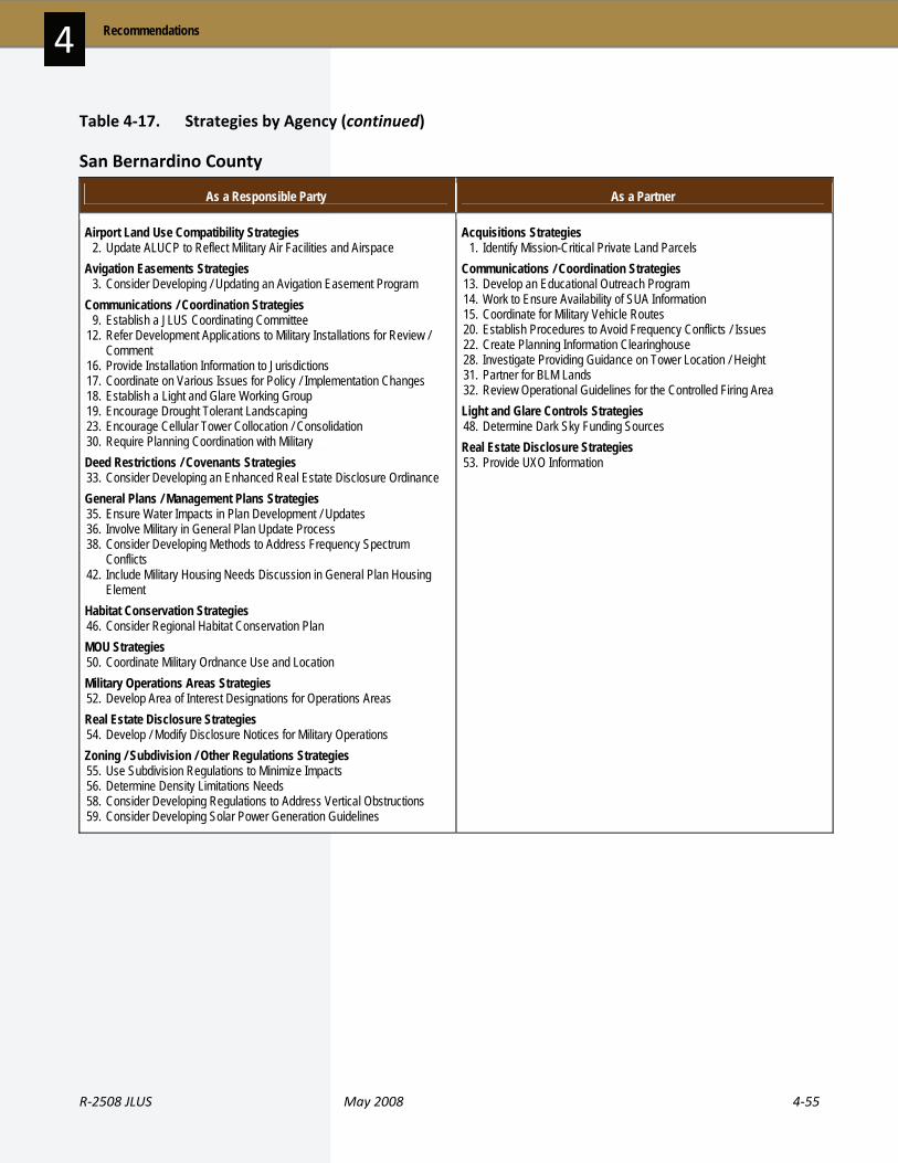
R‐2508 JLUS May 2008 4‐55
4 Recommendations
Table 4‐17. Strategies by Agency (continued)
San Bernardino County
As a Responsible Party As a Partner
Airport Land Use Compatibility Strategies 2. Update ALUCP to Reflect Military Air Facilities and Airspace Avigation Easements Strategies 3. Consider Developing / Updating an Avigation Easement Program Communications / Coordination Strategies 9. Establish a JLUS Coordinating Committee 12. Refer Development Applications to Military Installations for Review /
Comment 16. Provide Installation Information to Jurisdictions 17. Coordinate on Various Issues for Policy / Implementation Changes 18. Establish a Light and Glare Working Group 19. Encourage Drought Tolerant Landscaping 23. Encourage Cellular Tower Collocation / Consolidation 30. Require Planning Coordination with Military Deed Restrictions / Covenants Strategies 33. Consider Developing an Enhanced Real Estate Disclosure Ordinance General Plans / Management Plans Strategies 35. Ensure Water Impacts in Plan Development / Updates 36. Involve Military in General Plan Update Process 38. Consider Developing Methods to Address Frequency Spectrum
Conflicts 42. Include Military Housing Needs Discussion in General Plan Housing
Element Habitat Conservation Strategies 46. Consider Regional Habitat Conservation Plan MOU Strategies 50. Coordinate Military Ordnance Use and Location Military Operations Areas Strategies 52. Develop Area of Interest Designations for Operations Areas Real Estate Disclosure Strategies 54. Develop / Modify Disclosure Notices for Military Operations Zoning / Subdivision / Other Regulations Strategies 55. Use Subdivision Regulations to Minimize Impacts 56. Determine Density Limitations Needs 58. Consider Developing Regulations to Address Vertical Obstructions 59. Consider Developing Solar Power Generation Guidelines
Acquisitions Strategies 1. Identify Mission-Critical Private Land Parcels Communications / Coordination Strategies 13. Develop an Educational Outreach Program 14. Work to Ensure Availability of SUA Information 15. Coordinate for Military Vehicle Routes 20. Establish Procedures to Avoid Frequency Conflicts / Issues 22. Create Planning Information Clearinghouse 28. Investigate Providing Guidance on Tower Location / Height 31. Partner for BLM Lands 32. Review Operational Guidelines for the Controlled Firing Area Light and Glare Controls Strategies 48. Determine Dark Sky Funding Sources Real Estate Disclosure Strategies 53. Provide UXO Information

4‐56 May 2008 R‐2508 JLUS
Recommendations 4
Table 4‐17. Strategies by Agency (continued)
Tulare County
As a Responsible Party As a Partner
Airport Land Use Compatibility Strategies 2. Update ALUCP to Reflect Military Air Facilities and Airspace Communications / Coordination Strategies 9. Establish a JLUS Coordinating Committee 12. Refer Development Applications to Military Installations for Review /
Comment 16. Provide Installation Information to Jurisdictions 17. Coordinate on Various Issues for Policy / Implementation Changes 18. Establish a Light and Glare Working Group 23. Encourage Cellular Tower Collocation / Consolidation 30. Require Planning Coordination with Military Deed Restrictions / Covenants Strategies 33. Consider Developing an Enhanced Real Estate Disclosure Ordinance General Plans / Management Plans Strategies 36. Involve Military in General Plan Update Process 38. Consider Developing Methods to Address Frequency Spectrum
Conflicts Military Operations Areas Strategies 52. Develop Area of Interest Designations for Operations Areas Real Estate Disclosure Strategies 54. Develop / Modify Disclosure Notices for Military Operations Zoning / Subdivision / Other Regulations Strategies 58. Consider Developing Regulations to Address Vertical Obstructions 59. Consider Developing Solar Power Generation Guidelines
Acquisitions Strategies 1. Identify Mission-Critical Private Land Parcels Communications / Coordination Strategies 13. Develop an Educational Outreach Program 14. Work to Ensure Availability of SUA Information 22. Create Planning Information Clearinghouse 28. Investigate Providing Guidance on Tower Location / Height 31. Partner for BLM Lands Light and Glare Controls Strategies 48. Determine Dark Sky Funding Sources Real Estate Disclosure Strategies 53. Provide UXO Information
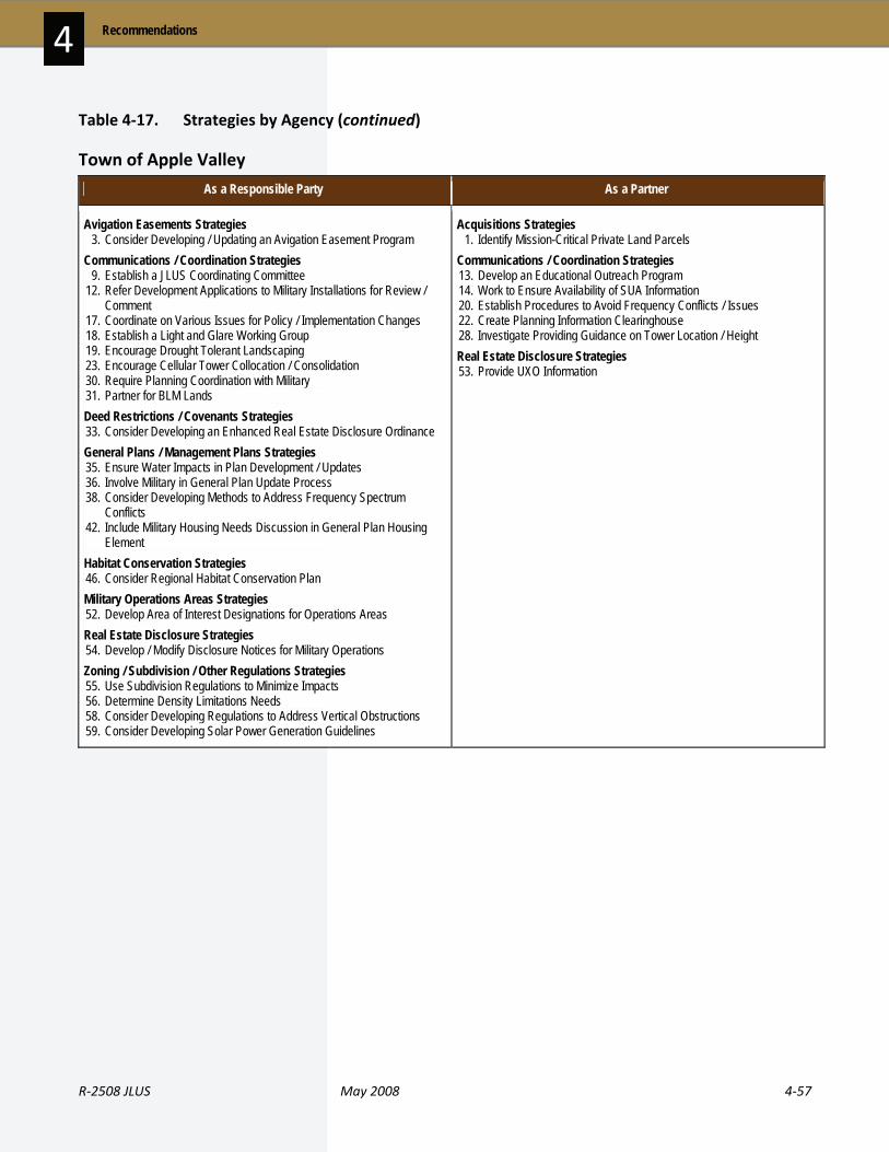
R‐2508 JLUS May 2008 4‐57
4 Recommendations
Table 4‐17. Strategies by Agency (continued)
Town of Apple Valley
As a Responsible Party As a Partner
Avigation Easements Strategies 3. Consider Developing / Updating an Avigation Easement Program Communications / Coordination Strategies 9. Establish a JLUS Coordinating Committee 12. Refer Development Applications to Military Installations for Review /
Comment 17. Coordinate on Various Issues for Policy / Implementation Changes 18. Establish a Light and Glare Working Group 19. Encourage Drought Tolerant Landscaping 23. Encourage Cellular Tower Collocation / Consolidation 30. Require Planning Coordination with Military 31. Partner for BLM Lands Deed Restrictions / Covenants Strategies 33. Consider Developing an Enhanced Real Estate Disclosure Ordinance General Plans / Management Plans Strategies 35. Ensure Water Impacts in Plan Development / Updates 36. Involve Military in General Plan Update Process 38. Consider Developing Methods to Address Frequency Spectrum
Conflicts 42. Include Military Housing Needs Discussion in General Plan Housing
Element Habitat Conservation Strategies 46. Consider Regional Habitat Conservation Plan Military Operations Areas Strategies 52. Develop Area of Interest Designations for Operations Areas Real Estate Disclosure Strategies 54. Develop / Modify Disclosure Notices for Military Operations Zoning / Subdivision / Other Regulations Strategies 55. Use Subdivision Regulations to Minimize Impacts 56. Determine Density Limitations Needs 58. Consider Developing Regulations to Address Vertical Obstructions 59. Consider Developing Solar Power Generation Guidelines
Acquisitions Strategies 1. Identify Mission-Critical Private Land Parcels Communications / Coordination Strategies 13. Develop an Educational Outreach Program 14. Work to Ensure Availability of SUA Information 20. Establish Procedures to Avoid Frequency Conflicts / Issues 22. Create Planning Information Clearinghouse 28. Investigate Providing Guidance on Tower Location / Height Real Estate Disclosure Strategies 53. Provide UXO Information
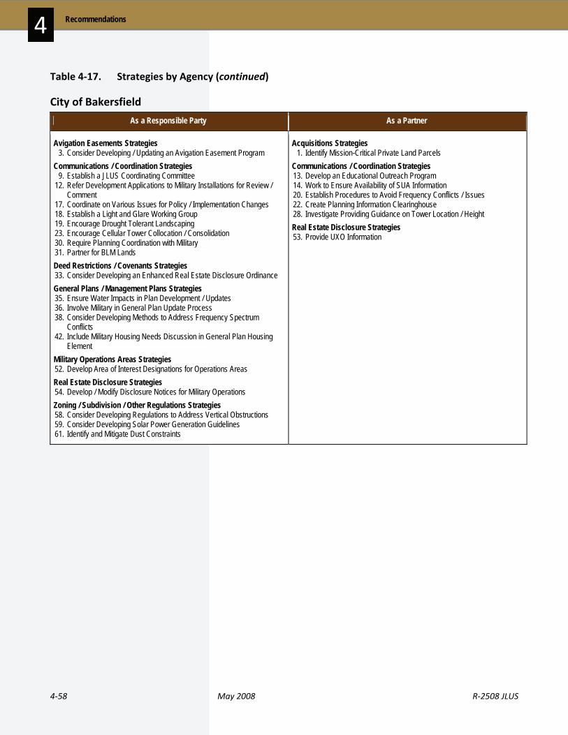
4‐58 May 2008 R‐2508 JLUS
Recommendations 4
Table 4‐17. Strategies by Agency (continued)
City of Bakersfield
As a Responsible Party As a Partner
Avigation Easements Strategies 3. Consider Developing / Updating an Avigation Easement Program Communications / Coordination Strategies 9. Establish a JLUS Coordinating Committee 12. Refer Development Applications to Military Installations for Review /
Comment 17. Coordinate on Various Issues for Policy / Implementation Changes 18. Establish a Light and Glare Working Group 19. Encourage Drought Tolerant Landscaping 23. Encourage Cellular Tower Collocation / Consolidation 30. Require Planning Coordination with Military 31. Partner for BLM Lands Deed Restrictions / Covenants Strategies 33. Consider Developing an Enhanced Real Estate Disclosure Ordinance General Plans / Management Plans Strategies 35. Ensure Water Impacts in Plan Development / Updates 36. Involve Military in General Plan Update Process 38. Consider Developing Methods to Address Frequency Spectrum
Conflicts 42. Include Military Housing Needs Discussion in General Plan Housing
Element Military Operations Areas Strategies 52. Develop Area of Interest Designations for Operations Areas Real Estate Disclosure Strategies 54. Develop / Modify Disclosure Notices for Military Operations Zoning / Subdivision / Other Regulations Strategies 58. Consider Developing Regulations to Address Vertical Obstructions 59. Consider Developing Solar Power Generation Guidelines 61. Identify and Mitigate Dust Constraints
Acquisitions Strategies 1. Identify Mission-Critical Private Land Parcels Communications / Coordination Strategies 13. Develop an Educational Outreach Program 14. Work to Ensure Availability of SUA Information 20. Establish Procedures to Avoid Frequency Conflicts / Issues 22. Create Planning Information Clearinghouse 28. Investigate Providing Guidance on Tower Location / Height Real Estate Disclosure Strategies 53. Provide UXO Information

R‐2508 JLUS May 2008 4‐59
4 Recommendations
Table 4‐17. Strategies by Agency (continued)
City of Barstow
As a Responsible Party As a Partner
Avigation Easements Strategies 3. Consider Developing / Updating an Avigation Easement Program Communications / Coordination Strategies 9. Establish a JLUS Coordinating Committee 12. Refer Development Applications to Military Installations for Review /
Comment 17. Coordinate on Various Issues for Policy / Implementation Changes 18. Establish a Light and Glare Working Group 19. Encourage Drought Tolerant Landscaping 23. Encourage Cellular Tower Collocation / Consolidation 30. Require Planning Coordination with Military 31. Partner for BLM Lands Deed Restrictions / Covenants Strategies 33. Consider Developing an Enhanced Real Estate Disclosure Ordinance General Plans / Management Plans Strategies 35. Ensure Water Impacts in Plan Development / Updates 36. Involve Military in General Plan Update Process 38. Consider Developing Methods to Address Frequency Spectrum
Conflicts 42. Include Military Housing Needs Discussion in General Plan Housing
Element Habitat Conservation Strategies 46. Consider Regional Habitat Conservation Plan Military Operations Areas Strategies 52. Develop Area of Interest Designations for Operations Areas Real Estate Disclosure Strategies 54. Develop / Modify Disclosure Notices for Military Operations Zoning / Subdivision / Other Regulations Strategies 55. Use Subdivision Regulations to Minimize Impacts 56. Determine Density Limitations Needs 58. Consider Developing Regulations to Address Vertical Obstructions 59. Consider Developing Solar Power Generation Guidelines 61. Identify and Mitigate of Dust Constraints
Acquisitions Strategies 1. Identify Mission-Critical Private Land Parcels Communications / Coordination Strategies 13. Develop an Educational Outreach Program 14. Work to Ensure Availability of SUA Information 20. Establish Procedures to Avoid Frequency Conflicts / Issues 22. Create Planning Information Clearinghouse 28. Investigate Providing Guidance on Tower Location / Height Light and Glare Controls Strategies 48. Determine Dark Sky Funding Sources Real Estate Disclosure Strategies 53. Provide UXO Information

4‐60 May 2008 R‐2508 JLUS
Recommendations 4
Table 4‐17. Strategies by Agency (continued)
City of California City
As a Responsible Party As a Partner
Airport Land Use Compatibility Strategies 2. Update ALUCP to Reflect Military Air Facilities and Airspace Avigation Easements Strategies 3. Consider Developing / Updating an Avigation Easement Program CIP Strategies 4. Promote Sustainable and Compatibility-Oriented Transportation
Projects 8. Identify Gate Needs for Edwards AFB Communications / Coordination Strategies 9. Establish a JLUS Coordinating Committee 11. Continue to Participate in Antelope Valley Water Group 12. Refer Development Applications to Military Installations for Review /
Comment 16. Provide Installation Information to Jurisdictions 17. Coordinate on Various Issues for Policy / Implementation Changes 18. Establish a Light and Glare Working Group 19. Encourage Drought Tolerant Landscaping 23. Encourage Cellular Tower Collocation / Consolidation 30. Require Planning Coordination with Military 31. Partner for BLM Lands Deed Restrictions / Covenants Strategies 33. Consider Developing an Enhanced Real Estate Disclosure Ordinance General Plans / Management Plans Strategies 35. Ensure Water Impacts in Plan Development / Updates 36. Involve Military in General Plan Update Process 38. Consider Developing Methods to Address Frequency Spectrum
Conflicts 41. Investigate Infill and Densification 42. Include Military Housing Needs Discussion in General Plan Housing
Element 44. Evaluate California City Sphere of Influence 45. Encourage Trip Reduction Techniques Habitat Conservation Strategies 46. Consider Regional Habitat Conservation Plan Military Operations Areas Strategies 52. Develop Area of Interest Designations for Operations Areas Real Estate Disclosure Strategies 54. Develop / Modify Disclosure Notices for Military Operations Zoning / Subdivision / Other Regulations Strategies 55. Use Subdivision Regulations to Minimize Impacts 56. Determine Density Limitations Needs 58. Consider Developing Regulations to Address Vertical Obstructions 59. Consider Developing Solar Power Generation Guidelines 60. Remove Residential Tower Exemptions 61. Identify and Mitigate Dust Constraints
Acquisitions Strategies 1. Identify Mission-Critical Private Land Parcels Communications / Coordination Strategies 13. Develop an Educational Outreach Program 14. Work to Ensure Availability of SUA Information 20. Establish Procedures to Avoid Frequency Conflicts / Issues 22. Create Planning Information Clearinghouse 28. Investigate Providing Guidance on Tower Location / Height Light and Glare Controls Strategies 48. Determine Dark Sky Funding Sources Real Estate Disclosure Strategies 53. Provide UXO Information

R‐2508 JLUS May 2008 4‐61
4 Recommendations
Table 4‐17. Strategies by Agency (continued)
City of Lancaster
As a Responsible Party As a Partner
Avigation Easements Strategies 3. Consider Developing / Updating an Avigation Easement Program CIP Strategies 6. Establish Plans and Requirements for Reclaimed Water 8. Identify Gate Needs for Edwards AFB Communications / Coordination Strategies 9. Establish a JLUS Coordinating Committee 11. Continue to Participate in Antelope Valley Water Group 12. Refer Development Applications to Military Installations for Review /
Comment 17. Coordinate on Various Issues for Policy / Implementation Changes 18. Establish a Light and Glare Working Group 19. Encourage Drought Tolerant Landscaping 23. Encourage Cellular Tower Collocation / Consolidation 30. Require Planning Coordination with Military 31. Partner for BLM Lands Deed Restrictions / Covenants Strategies 33. Consider Developing an Enhanced Real Estate Disclosure Ordinance General Plans / Management Plans Strategies 35. Ensure Water Impacts in Plan Development / Updates 36. Involve Military in General Plan Update Process 38. Consider Developing Methods to Address Frequency Spectrum
Conflicts 42. Include Military Housing Needs Discussion in General Plan Housing
Element 45. Encourage Trip Reduction Techniques Habitat Conservation Strategies 46. Consider Regional Habitat Conservation Plan Military Operations Areas Strategies 52. Develop Area of Interest Designations for Operations Areas Real Estate Disclosure Strategies 54. Develop / Modify Disclosure Notices for Military Operations Zoning / Subdivision / Other Regulations Strategies 58. Consider Developing Regulations to Address Vertical Obstructions 59. Consider Developing Solar Power Generation Guidelines 61. Identify and Mitigate Dust Constraints
Acquisitions Strategies 1. Identify Mission-Critical Private Land Parcels Communications / Coordination Strategies 13. Develop an Educational Outreach Program 14. Work to Ensure Availability of SUA Information 20. Establish Procedures to Avoid Frequency Conflicts / Issues 22. Create Planning Information Clearinghouse 28. Investigate Providing Guidance on Tower Location / Height Light and Glare Controls Strategies 48. Determine Dark Sky Funding Sources Real Estate Disclosure Strategies 53. Provide UXO Information

4‐62 May 2008 R‐2508 JLUS
Recommendations 4
Table 4‐17. Strategies by Agency (continued)
City of Palmdale
As a Responsible Party As a Partner
Avigation Easements Strategies 3. Consider Developing / Updating an Avigation Easement Program CIP Strategies 8. Identify Gate Needs for Edwards AFB Communications / Coordination Strategies 9. Establish a JLUS Coordinating Committee 11. Continue to Participate in Antelope Valley Water Group 12. Refer Development Applications to Military Installations for Review /
Comment 17. Coordinate on Various Issues for Policy / Implementation Changes 18. Establish a Light and Glare Working Group 19. Encourage Drought Tolerant Landscaping 30. Require Planning Coordination with Military 31. Partner for BLM Lands Deed Restrictions / Covenants Strategies 33. Consider Developing an Enhanced Real Estate Disclosure Ordinance General Plans / Management Plans Strategies 35. Ensure Water Impacts in Plan Development / Updates 36. Involve Military in General Plan Update Process 38. Consider Developing Methods to Address Frequency Spectrum
Conflicts 42. Include Military Housing Needs Discussion in General Plan Housing
Element 45. Encourage Trip Reduction Techniques Habitat Conservation Strategies 46. Consider Regional Habitat Conservation Plan Military Operations Areas Strategies 52. Develop Area of Interest Designations for Operations Areas Real Estate Disclosure Strategies 54. Develop / Modify Disclosure Notices for Military Operations Zoning / Subdivision / Other Regulations Strategies 58. Consider Developing Regulations to Address Vertical Obstructions 59. Consider Developing Solar Power Generation Guidelines 61. Identify and Mitigate Dust Constraints
Acquisitions Strategies 1. Identify Mission-Critical Private Land Parcels Communications / Coordination Strategies 13. Develop an Educational Outreach Program 14. Work to Ensure Availability of SUA Information 22. Create Planning Information Clearinghouse 28. Investigate Providing Guidance on Tower Location / Height Real Estate Disclosure Strategies 53. Provide UXO Information
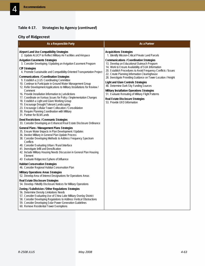
R‐2508 JLUS May 2008 4‐63
4 Recommendations
Table 4‐17. Strategies by Agency (continued)
City of Ridgecrest
As a Responsible Party As a Partner
Airport Land Use Compatibility Strategies 2. Update ALUCP to Reflect Military Air Facilities and Airspace Avigation Easements Strategies 3. Consider Developing / Updating an Avigation Easement Program CIP Strategies 4. Promote Sustainable and Compatibility-Oriented Transportation Project Communications / Coordination Strategies 9. Establish a JLUS Coordinating Committee 10. Continue to Participate in Ground Water Management Group 12. Refer Development Applications to Military Installations for Review /
Comment 16. Provide Installation Information to Jurisdictions 17. Coordinate on Various Issues for Policy / Implementation Changes 18. Establish a Light and Glare Working Group 19. Encourage Drought Tolerant Landscaping 23. Encourage Cellular Tower Collocation / Consolidation 30. Require Planning Coordination with Military 31. Partner for BLM Lands Deed Restrictions / Covenants Strategies 33. Consider Developing an Enhanced Real Estate Disclosure Ordinance General Plans / Management Plans Strategies 35. Ensure Water Impacts in Plan Development / Updates 36. Involve Military in General Plan Update Process 38. Consider Developing Methods to Address Frequency Spectrum
Conflicts 40. Consider Evaluating Urban / Rural Interface 41. Investigate Infill and Densification 42. Include Military Housing Needs Discussion in General Plan Housing
Element 43 Evaluate Ridgecrest Sphere of Influence Habitat Conservation Strategies 46. Consider Regional Habitat Conservation Plan Military Operations Areas Strategies 52. Develop Area of Interest Designations for Operations Areas Real Estate Disclosure Strategies 54. Develop / Modify Disclosure Notices for Military Operations Zoning / Subdivision / Other Regulations Strategies 56. Determine Density Limitations Needs 57. Consider Evaluating Use of China Lake Military Overlay District 58. Consider Developing Regulations to Address Vertical Obstructions 59. Consider Developing Solar Power Generation Guidelines 60. Remove Residential Tower Exemptions
Acquisitions Strategies 1. Identify Mission-Critical Private Land Parcels Communications / Coordination Strategies 13. Develop an Educational Outreach Program 14. Work to Ensure Availability of SUA Information 20. Establish Procedures to Avoid Frequency Conflicts / Issues 22. Create Planning Information Clearinghouse 28. Investigate Providing Guidance on Tower Location / Height Light and Glare Controls Strategies 48. Determine Dark Sky Funding Sources Military Installation Operations Strategies 51. Evaluate Rerouting of Military Flight Patterns Real Estate Disclosure Strategies 53. Provide UXO Information
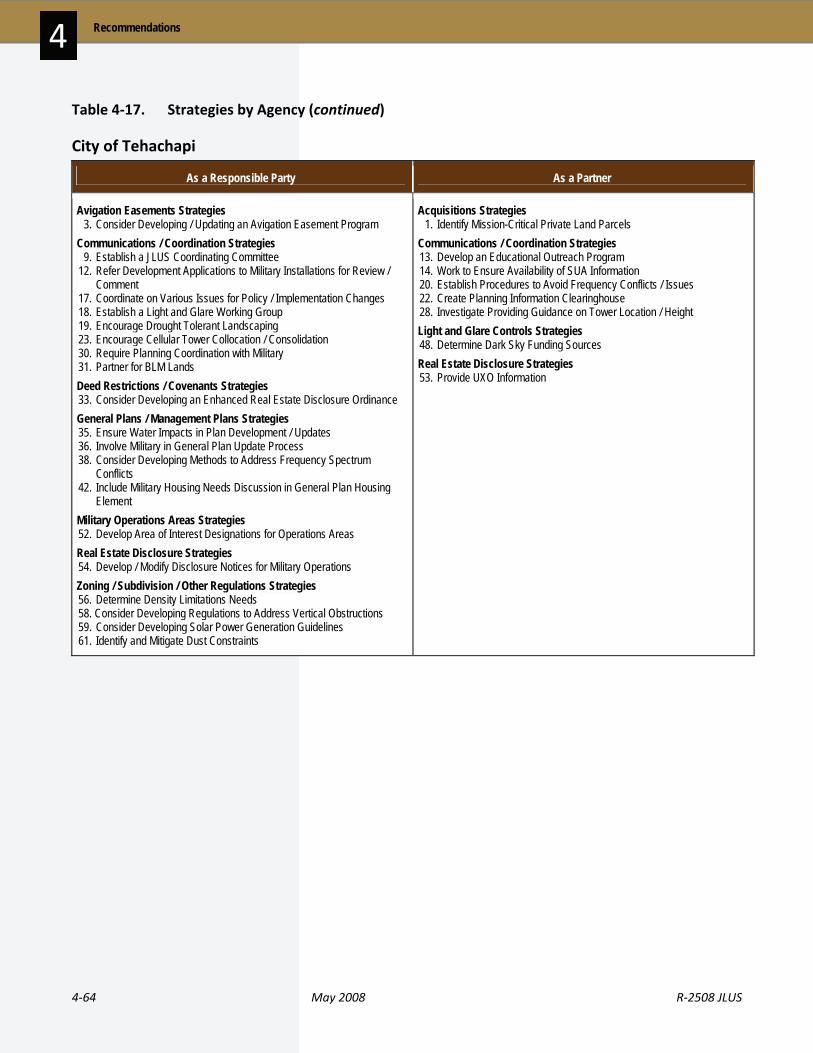
4‐64 May 2008 R‐2508 JLUS
Recommendations 4
Table 4‐17. Strategies by Agency (continued)
City of Tehachapi
As a Responsible Party As a Partner
Avigation Easements Strategies 3. Consider Developing / Updating an Avigation Easement Program Communications / Coordination Strategies 9. Establish a JLUS Coordinating Committee 12. Refer Development Applications to Military Installations for Review /
Comment 17. Coordinate on Various Issues for Policy / Implementation Changes 18. Establish a Light and Glare Working Group 19. Encourage Drought Tolerant Landscaping 23. Encourage Cellular Tower Collocation / Consolidation 30. Require Planning Coordination with Military 31. Partner for BLM Lands Deed Restrictions / Covenants Strategies 33. Consider Developing an Enhanced Real Estate Disclosure Ordinance General Plans / Management Plans Strategies 35. Ensure Water Impacts in Plan Development / Updates 36. Involve Military in General Plan Update Process 38. Consider Developing Methods to Address Frequency Spectrum
Conflicts 42. Include Military Housing Needs Discussion in General Plan Housing
Element Military Operations Areas Strategies 52. Develop Area of Interest Designations for Operations Areas Real Estate Disclosure Strategies 54. Develop / Modify Disclosure Notices for Military Operations Zoning / Subdivision / Other Regulations Strategies 56. Determine Density Limitations Needs 58. Consider Developing Regulations to Address Vertical Obstructions 59. Consider Developing Solar Power Generation Guidelines 61. Identify and Mitigate Dust Constraints
Acquisitions Strategies 1. Identify Mission-Critical Private Land Parcels Communications / Coordination Strategies 13. Develop an Educational Outreach Program 14. Work to Ensure Availability of SUA Information 20. Establish Procedures to Avoid Frequency Conflicts / Issues 22. Create Planning Information Clearinghouse 28. Investigate Providing Guidance on Tower Location / Height Light and Glare Controls Strategies 48. Determine Dark Sky Funding Sources Real Estate Disclosure Strategies 53. Provide UXO Information

R‐2508 JLUS May 2008 4‐65
4 Recommendations
Table 4‐17. Strategies by Agency (continued)
City of Victorville
As a Responsible Party As a Partner
Avigation Easements Strategies 3. Consider Developing / Updating an Avigation Easement Program Communications / Coordination Strategies 9. Establish a JLUS Coordinating Committee 12. Refer Development Applications to Military Installations for Review /
Comment 17. Coordinate on Various Issues for Policy / Implementation Changes 18. Establish a Light and Glare Working Group 19. Encourage Drought Tolerant Landscaping 29. Address Conflicts with High Speed Rail and Highway Projects Deed Restrictions / Covenants Strategies 33. Consider Developing an Enhanced Real Estate Disclosure Ordinance General Plans / Management Plans Strategies 35. Ensure Water Impacts in Plan Development / Updates 36. Involve Military in General Plan Update Process 38. Consider Developing Methods to Address Frequency Spectrum
Conflicts 42. Include Military Housing Needs Discussion in General Plan Housing
Element Habitat Conservation Strategies 46. Consider Regional Habitat Conservation Plan Military Operations Areas Strategies 52. Develop Area of Interest Designations for Operations Areas Real Estate Disclosure Strategies 54. Develop / Modify Disclosure Notices for Military Operations Zoning / Subdivision / Other Regulations Strategies 56. Determine Density Limitations Needs 58. Consider Developing Regulations to Address Vertical Obstructions 59. Consider Developing Solar Power Generation Guidelines
Acquisitions Strategies 1. Identify Mission-Critical Private Land Parcels Communications / Coordination Strategies 13. Develop an Educational Outreach Program 14. Work to Ensure Availability of SUA Information 20. Establish Procedures to Avoid Frequency Conflicts / Issues 22. Create Planning Information Clearinghouse 28. Investigate Providing Guidance on Tower Location / Height Real Estate Disclosure Strategies 53. Provide UXO Information

4‐66 May 2008 R‐2508 JLUS
Recommendations 4
Table 4‐17. Strategies by Agency (continued)
Native American Tribal Governments – San Manuel Band of Serrano Mission Indians
As a Responsible Party As a Partner
Acquisitions Strategies 1. Identify Mission-Critical Private Land Parcels Communications / Coordination Strategies 9. Establish a JLUS Coordinating Committee 13. Develop an Educational Outreach Program 31. Partner for BLM Lands Military Operations Areas Strategies 52. Develop Area of Interest Designations for Operations Areas
Native American Tribal Governments – Other Tribes
As a Responsible Party As a Partner
Acquisitions Strategies 1. Identify Mission-Critical Private Land Parcels Communications / Coordination Strategies 9. Establish a JLUS Coordinating Committee 13. Develop an Educational Outreach Program 31. Partner for BLM Lands Military Operations Areas Strategies 52. Develop Area of Interest Designations for Operations Areas
Councils of Governments
As a Responsible Party As a Partner
CIP Strategies 5. Investigate Critical Facilities Grade Separation Communications / Coordination Strategies 9. Establish a JLUS Coordinating Committee 29. Address Conflicts with High Speed Rail and Highway Projects
CIP Strategies 4. Promote Sustainable and Compatibility-Oriented Transportation
Projects

R‐2508 JLUS May 2008 4‐67
4 Recommendations
Table 4‐17. Strategies by Agency (continued)
China Lake
As a Responsible Party As a Partner
Acquisitions Strategies 1. Identify Mission-Critical Private Land Parcels Airport Land Use Compatibility Strategies 2. Update ALUCP to Reflect Military Air Facilities and Airspace CIP Strategies 7. Explore Use of Alternative Energy Sources Communications / Coordination Strategies 9. Establish a JLUS Coordinating Committee 10. Continue to Participate in Ground Water Management Group 14. Work to Ensure Availability of SUA Information 16. Provide Installation Information to Jurisdictions 17. Coordinate on Various Issues for Policy / Implementation Changes 18. Establish a Light and Glare Working Group 19. Encourage Drought Tolerant Landscaping 20. Establish Procedures to Avoid Frequency Conflicts / Issues 24. Work to Ensure Marking of Utility Lines 27. Review / Amend Controlled Burn Procedures 31. Partner for BLM Lands 32. Review Operational Guidelines for the Controlled Firing Area General Plans / Management Plans Strategies 40. Consider Evaluating Urban / Rural Interface 43. Evaluate Ridgecrest Sphere of Influence Light and Glare Controls Strategies 48. Determine Dark Sky Funding Sources MOU Strategies 49. Evaluate Implementation of Military Emission Reduction System Military Installation Operations Strategies 51. Evaluate Rerouting of Military Flight Patterns Military Operations Areas Strategies 52. Develop Area of Interest Designations for Operations Areas Zoning / Subdivision / Other Regulations Strategies 57. Consider Evaluating Use of China Lake Military Overlay District
Avigation Easements Strategies 3. Consider Developing / Updating an Avigation Easement Program Communications / Coordination Strategies 12. Refer Development Applications to Military Installations for Review /
Comment 13. Develop an Educational Outreach Program 21. Refer Specific BLM Development Applications to Military Installations
for Review / Comment 22. Create Planning Information Clearinghouse 25. Allow Military Review of Permit Applications 26. Work to Evaluate Use of Existing Transmission Corridors Deed Restrictions / Covenants Strategies 33. Consider Developing an Enhanced Real Estate Disclosure Ordinance General Plans / Management Plans Strategies 34. Review of Management Plans for Military Compatibility 36. Involve Military in General Plan Update Process 38. Consider Developing Methods to Address Frequency Spectrum
Conflicts 41. Investigate Infill and Densification 42. Include Military Housing Needs Discussion in General Plan Housing
Element Habitat Conservation Strategies 46. Consider Regional Habitat Conservation Plan Legislative Initiatives Strategies 47. Protect Military Missions with Wilderness Legislation Real Estate Disclosure Strategies 53. Provide UXO Information 54. Develop / Modify Disclosure Notices for Military Operations Zoning / Subdivision / Other Regulations Strategies 56. Determine Density Limitations Needs 58. Consider Developing Regulations to Address Vertical Obstructions 59. Consider Developing Solar Power Generation Guidelines 61. Identify and Mitigate Dust Constraints
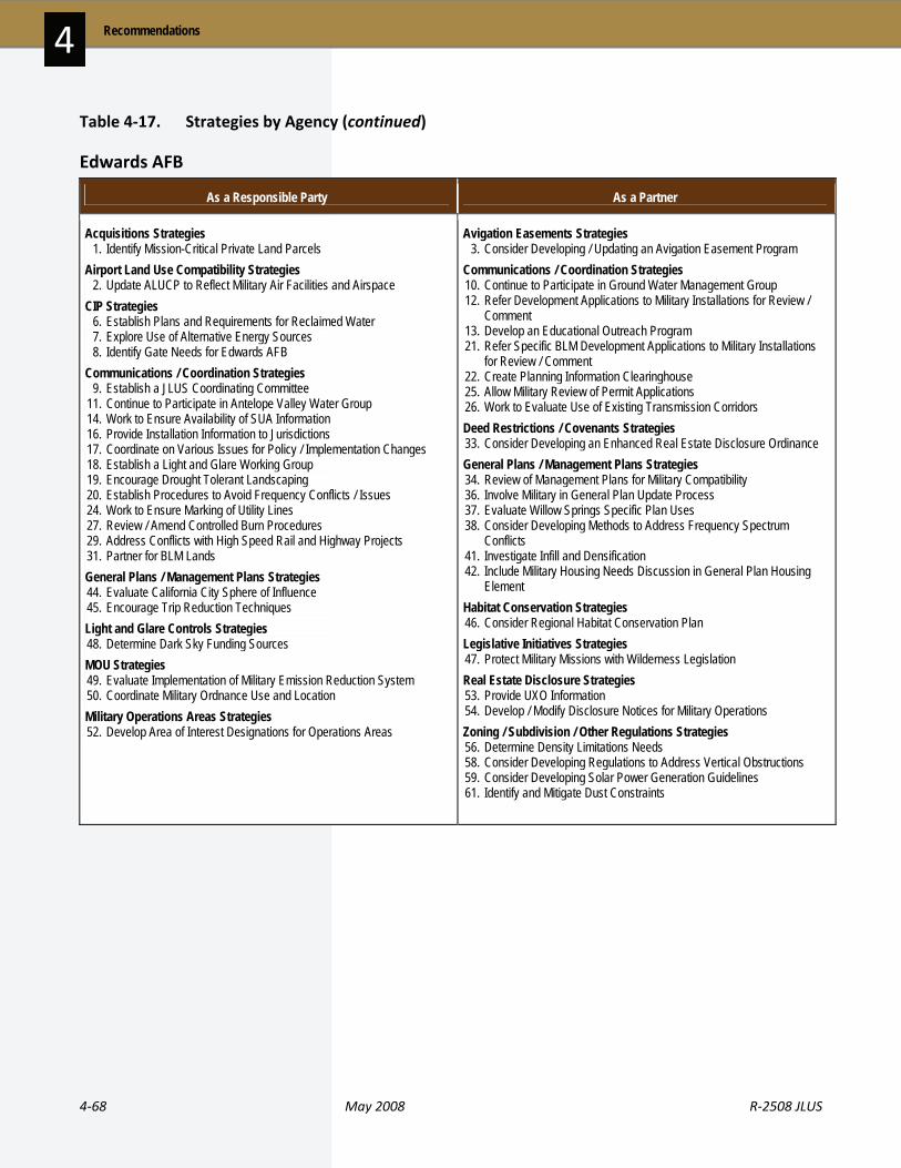
4‐68 May 2008 R‐2508 JLUS
Recommendations 4
Table 4‐17. Strategies by Agency (continued)
Edwards AFB
As a Responsible Party As a Partner
Acquisitions Strategies 1. Identify Mission-Critical Private Land Parcels Airport Land Use Compatibility Strategies 2. Update ALUCP to Reflect Military Air Facilities and Airspace CIP Strategies 6. Establish Plans and Requirements for Reclaimed Water 7. Explore Use of Alternative Energy Sources 8. Identify Gate Needs for Edwards AFB Communications / Coordination Strategies 9. Establish a JLUS Coordinating Committee 11. Continue to Participate in Antelope Valley Water Group 14. Work to Ensure Availability of SUA Information 16. Provide Installation Information to Jurisdictions 17. Coordinate on Various Issues for Policy / Implementation Changes 18. Establish a Light and Glare Working Group 19. Encourage Drought Tolerant Landscaping 20. Establish Procedures to Avoid Frequency Conflicts / Issues 24. Work to Ensure Marking of Utility Lines 27. Review / Amend Controlled Burn Procedures 29. Address Conflicts with High Speed Rail and Highway Projects 31. Partner for BLM Lands General Plans / Management Plans Strategies 44. Evaluate California City Sphere of Influence 45. Encourage Trip Reduction Techniques Light and Glare Controls Strategies 48. Determine Dark Sky Funding Sources MOU Strategies 49. Evaluate Implementation of Military Emission Reduction System 50. Coordinate Military Ordnance Use and Location Military Operations Areas Strategies 52. Develop Area of Interest Designations for Operations Areas
Avigation Easements Strategies 3. Consider Developing / Updating an Avigation Easement Program Communications / Coordination Strategies 10. Continue to Participate in Ground Water Management Group 12. Refer Development Applications to Military Installations for Review /
Comment 13. Develop an Educational Outreach Program 21. Refer Specific BLM Development Applications to Military Installations
for Review / Comment 22. Create Planning Information Clearinghouse 25. Allow Military Review of Permit Applications 26. Work to Evaluate Use of Existing Transmission Corridors Deed Restrictions / Covenants Strategies 33. Consider Developing an Enhanced Real Estate Disclosure Ordinance General Plans / Management Plans Strategies 34. Review of Management Plans for Military Compatibility 36. Involve Military in General Plan Update Process 37. Evaluate Willow Springs Specific Plan Uses 38. Consider Developing Methods to Address Frequency Spectrum
Conflicts 41. Investigate Infill and Densification 42. Include Military Housing Needs Discussion in General Plan Housing
Element Habitat Conservation Strategies 46. Consider Regional Habitat Conservation Plan Legislative Initiatives Strategies 47. Protect Military Missions with Wilderness Legislation Real Estate Disclosure Strategies 53. Provide UXO Information 54. Develop / Modify Disclosure Notices for Military Operations Zoning / Subdivision / Other Regulations Strategies 56. Determine Density Limitations Needs 58. Consider Developing Regulations to Address Vertical Obstructions 59. Consider Developing Solar Power Generation Guidelines 61. Identify and Mitigate Dust Constraints
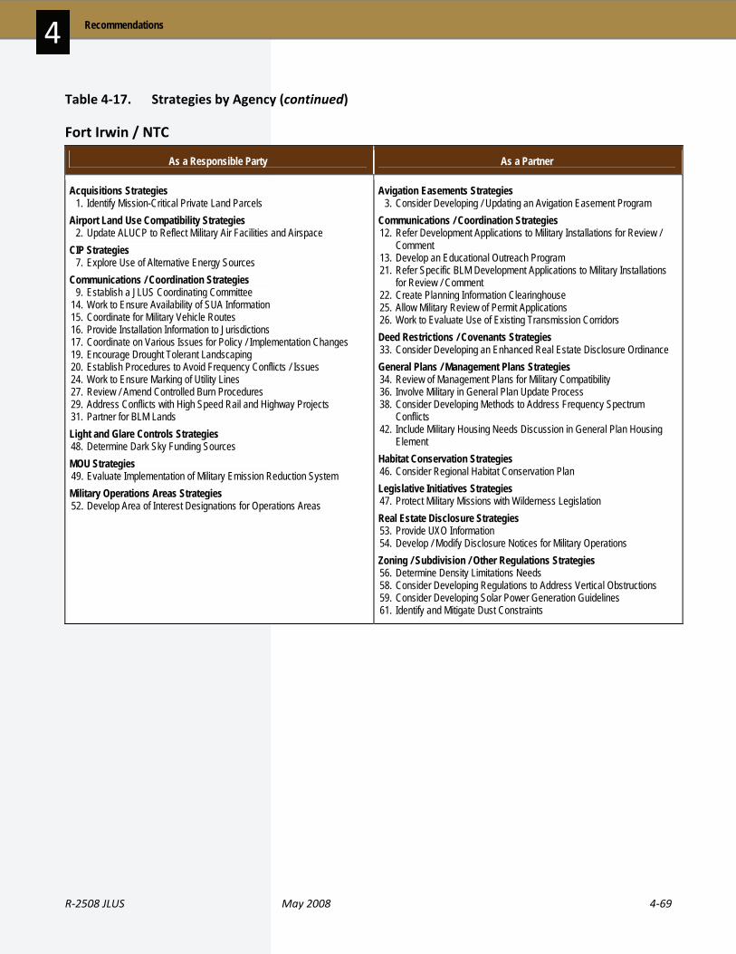
R‐2508 JLUS May 2008 4‐69
4 Recommendations
Table 4‐17. Strategies by Agency (continued)
Fort Irwin / NTC
As a Responsible Party As a Partner
Acquisitions Strategies 1. Identify Mission-Critical Private Land Parcels Airport Land Use Compatibility Strategies 2. Update ALUCP to Reflect Military Air Facilities and Airspace CIP Strategies 7. Explore Use of Alternative Energy Sources Communications / Coordination Strategies 9. Establish a JLUS Coordinating Committee 14. Work to Ensure Availability of SUA Information 15. Coordinate for Military Vehicle Routes 16. Provide Installation Information to Jurisdictions 17. Coordinate on Various Issues for Policy / Implementation Changes 19. Encourage Drought Tolerant Landscaping 20. Establish Procedures to Avoid Frequency Conflicts / Issues 24. Work to Ensure Marking of Utility Lines 27. Review / Amend Controlled Burn Procedures 29. Address Conflicts with High Speed Rail and Highway Projects 31. Partner for BLM Lands Light and Glare Controls Strategies 48. Determine Dark Sky Funding Sources MOU Strategies 49. Evaluate Implementation of Military Emission Reduction System Military Operations Areas Strategies 52. Develop Area of Interest Designations for Operations Areas
Avigation Easements Strategies 3. Consider Developing / Updating an Avigation Easement Program Communications / Coordination Strategies 12. Refer Development Applications to Military Installations for Review /
Comment 13. Develop an Educational Outreach Program 21. Refer Specific BLM Development Applications to Military Installations
for Review / Comment 22. Create Planning Information Clearinghouse 25. Allow Military Review of Permit Applications 26. Work to Evaluate Use of Existing Transmission Corridors Deed Restrictions / Covenants Strategies 33. Consider Developing an Enhanced Real Estate Disclosure Ordinance General Plans / Management Plans Strategies 34. Review of Management Plans for Military Compatibility 36. Involve Military in General Plan Update Process 38. Consider Developing Methods to Address Frequency Spectrum
Conflicts 42. Include Military Housing Needs Discussion in General Plan Housing
Element Habitat Conservation Strategies 46. Consider Regional Habitat Conservation Plan Legislative Initiatives Strategies 47. Protect Military Missions with Wilderness Legislation Real Estate Disclosure Strategies 53. Provide UXO Information 54. Develop / Modify Disclosure Notices for Military Operations Zoning / Subdivision / Other Regulations Strategies 56. Determine Density Limitations Needs 58. Consider Developing Regulations to Address Vertical Obstructions 59. Consider Developing Solar Power Generation Guidelines 61. Identify and Mitigate Dust Constraints
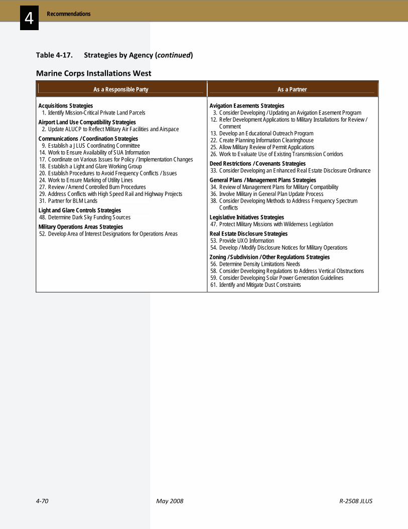
4‐70 May 2008 R‐2508 JLUS
Recommendations 4
Table 4‐17. Strategies by Agency (continued)
Marine Corps Installations West
As a Responsible Party As a Partner
Acquisitions Strategies 1. Identify Mission-Critical Private Land Parcels Airport Land Use Compatibility Strategies 2. Update ALUCP to Reflect Military Air Facilities and Airspace Communications / Coordination Strategies 9. Establish a JLUS Coordinating Committee 14. Work to Ensure Availability of SUA Information 17. Coordinate on Various Issues for Policy / Implementation Changes 18. Establish a Light and Glare Working Group 20. Establish Procedures to Avoid Frequency Conflicts / Issues 24. Work to Ensure Marking of Utility Lines 27. Review / Amend Controlled Burn Procedures 29. Address Conflicts with High Speed Rail and Highway Projects 31. Partner for BLM Lands Light and Glare Controls Strategies 48. Determine Dark Sky Funding Sources Military Operations Areas Strategies 52. Develop Area of Interest Designations for Operations Areas
Avigation Easements Strategies 3. Consider Developing / Updating an Avigation Easement Program 12. Refer Development Applications to Military Installations for Review /
Comment 13. Develop an Educational Outreach Program 22. Create Planning Information Clearinghouse 25. Allow Military Review of Permit Applications 26. Work to Evaluate Use of Existing Transmission Corridors Deed Restrictions / Covenants Strategies 33. Consider Developing an Enhanced Real Estate Disclosure Ordinance General Plans / Management Plans Strategies 34. Review of Management Plans for Military Compatibility 36. Involve Military in General Plan Update Process 38. Consider Developing Methods to Address Frequency Spectrum
Conflicts Legislative Initiatives Strategies 47. Protect Military Missions with Wilderness Legislation Real Estate Disclosure Strategies 53. Provide UXO Information 54. Develop / Modify Disclosure Notices for Military Operations Zoning / Subdivision / Other Regulations Strategies 56. Determine Density Limitations Needs 58. Consider Developing Regulations to Address Vertical Obstructions 59. Consider Developing Solar Power Generation Guidelines 61. Identify and Mitigate Dust Constraints

R‐2508 JLUS May 2008 4‐71
4 Recommendations
Table 4‐17. Strategies by Agency (continued)
Bureau of Land Management
As a Responsible Party As a Partner
Communications / Coordination Strategies 9. Establish a JLUS Coordinating Committee 12. Refer Development Applications to Military Installations for Review /
Comment 17. Coordinate on Various Issues for Policy / Implementation Changes 18. Establish a Light and Glare Working Group 21. Refer Specific BLM Development Applications to Military Installations
for Review / Comment 23. Encourage Cellular Tower Collocation / Consolidation 25. Allow Military Review of Permit Applications 27. Review / Amend Controlled Burn Procedures 29. Address Conflicts with High Speed Rail and Highway Projects 31. Partner for BLM Lands 32. Review Operational Guidelines for the Controlled Firing Area General Plans / Management Plans Strategies 34. Review of Management Plans for Military Compatibility 36. Involve Military in General Plan Update Process 40. Consider Evaluating Urban / Rural Interface MOU Strategies 50. Coordinate Military Ordnance Use and Location Real Estate Disclosure Strategies 58. Consider Developing Regulations to Address Vertical Obstructions Zoning / Subdivision / Other Regulations Strategies 59. Consider Developing Solar Power Generation Guidelines 61. Identify and Mitigate Dust Constraints
Acquisitions Strategies 1. Identify Mission-Critical Private Land Parcels Communications / Coordination Strategies 15. Coordinate for Military Vehicle Routes 26. Work to Evaluate Use of Existing Transmission Corridors 28. Investigate Providing Guidance on Tower Location / Height Habitat Conservation Strategies 46. Consider Regional Habitat Conservation Plan Legislative Initiatives Strategies 47. Protect Military Missions with Wilderness Legislation Military Installation Operations Strategies 51. Evaluate Rerouting of Military Flight Patterns Real Estate Disclosure Strategies 53. Provide UXO Information
National Park Service
As a Responsible Party As a Partner
Communications / Coordination Strategies 9. Establish a JLUS Coordinating Committee 23. Encourage Cellular Tower Collocation / Consolidation 27. Review / Amend Controlled Burn Procedures General Plans / Management Plans Strategies 34. Review of Management Plans for Military Compatibility Zoning / Subdivision / Other Regulations Strategies 61. Identify and Mitigate Dust Constraints
Communications / Coordination Strategies 31. Partner for BLM Lands Legislative Initiatives Strategies 47. Protect Military Missions with Wilderness Legislation Real Estate Disclosure Strategies 53. Provide UXO Information
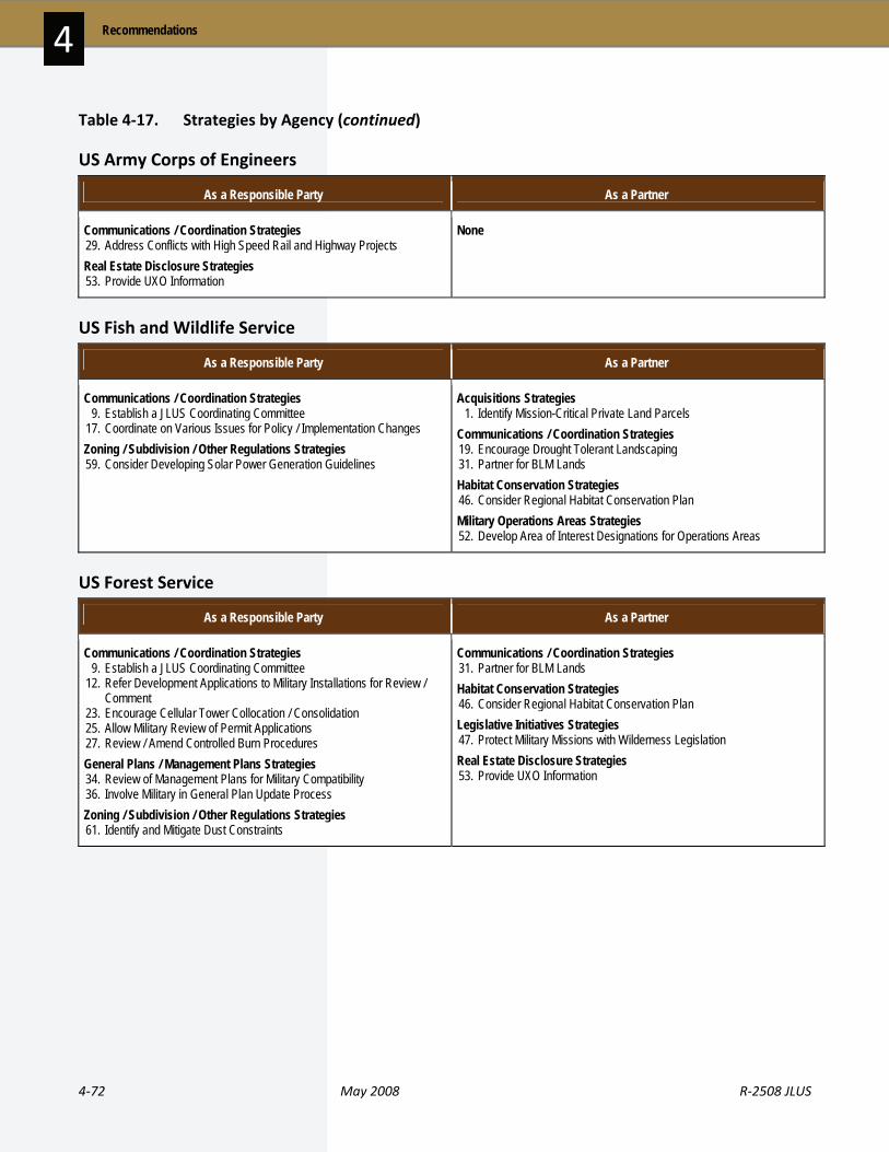
4‐72 May 2008 R‐2508 JLUS
Recommendations 4
Table 4‐17. Strategies by Agency (continued)
US Army Corps of Engineers
As a Responsible Party As a Partner
Communications / Coordination Strategies 29. Address Conflicts with High Speed Rail and Highway Projects Real Estate Disclosure Strategies 53. Provide UXO Information
None
US Fish and Wildlife Service
As a Responsible Party As a Partner
Communications / Coordination Strategies 9. Establish a JLUS Coordinating Committee 17. Coordinate on Various Issues for Policy / Implementation Changes Zoning / Subdivision / Other Regulations Strategies 59. Consider Developing Solar Power Generation Guidelines
Acquisitions Strategies 1. Identify Mission-Critical Private Land Parcels Communications / Coordination Strategies 19. Encourage Drought Tolerant Landscaping 31. Partner for BLM Lands Habitat Conservation Strategies 46. Consider Regional Habitat Conservation Plan Military Operations Areas Strategies 52. Develop Area of Interest Designations for Operations Areas
US Forest Service
As a Responsible Party As a Partner
Communications / Coordination Strategies 9. Establish a JLUS Coordinating Committee 12. Refer Development Applications to Military Installations for Review /
Comment 23. Encourage Cellular Tower Collocation / Consolidation 25. Allow Military Review of Permit Applications 27. Review / Amend Controlled Burn Procedures General Plans / Management Plans Strategies 34. Review of Management Plans for Military Compatibility 36. Involve Military in General Plan Update Process Zoning / Subdivision / Other Regulations Strategies 61. Identify and Mitigate Dust Constraints
Communications / Coordination Strategies 31. Partner for BLM Lands Habitat Conservation Strategies 46. Consider Regional Habitat Conservation Plan Legislative Initiatives Strategies 47. Protect Military Missions with Wilderness Legislation Real Estate Disclosure Strategies 53. Provide UXO Information

R‐2508 JLUS May 2008 4‐73
4 Recommendations
Table 4‐17. Strategies by Agency (continued)
California Department of Fish and Game
As a Responsible Party As a Partner
Communications / Coordination Strategies 9. Establish a JLUS Coordinating Committee 17. Coordinate on Various Issues for Policy / Implementation Changes General Plans / Management Plans Strategies 36. Involve Military in General Plan Update Process Zoning / Subdivision / Other Regulations Strategies 59. Consider Developing Solar Power Generation Guidelines
Acquisitions Strategies 1. Identify Mission-Critical Private Land Parcels Communications / Coordination Strategies 10. Continue to Participate in Ground Water Management Group 31. Partner for BLM Lands Habitat Conservation Strategies 46. Consider Regional Habitat Conservation Plan Military Operations Areas Strategies 52. Develop Area of Interest Designations for Operations Areas Zoning / Subdivision / Other Regulations Strategies 61. Identify and Mitigate Dust Constraints
Caltrans
As a Responsible Party As a Partner
CIP Strategies 4. Promote Sustainable and Compatibility-Oriented Transportation
Projects Communications / Coordination Strategies 9. Establish a JLUS Coordinating Committee 12. Refer Development Applications to Military Installations for Review /
Comment 29. Address Conflicts with High Speed Rail and Highway Projects General Plans / Management Plans Strategies 34. Review of Management Plans for Military Compatibility 36. Involve Military in General Plan Update Process Zoning / Subdivision / Other Regulations Strategies 61. Identify and Mitigate Dust Constraints
Communications / Coordination Strategies 14. Work to Ensure Availability of SUA Information 15. Coordinate for Military Vehicle Routes
Department of Toxic Substances Control
As a Responsible Party As a Partner
Communications / Coordination Strategies 9. Establish a JLUS Coordinating Committee
Real Estate Disclosure Strategies 53. Provide UXO Information

4‐74 May 2008 R‐2508 JLUS
Recommendations 4
Table 4‐17. Strategies by Agency (continued)
Legislative / State and Federal
As a Responsible Party As a Partner
Communications / Coordination Strategies 13. Develop an Educational Outreach Program 14. Work to Ensure Availability of SUA Information 16. Provide Installation Information to Jurisdictions 22. Create Planning Information Clearinghouse 28. Investigate Providing Guidance on Tower Location / Height Legislative Initiatives Strategies 47. Protect Military Missions with Wilderness Legislation Zoning / Subdivision / Other Regulations Strategies 60. Remove Residential Tower Exemptions
None
Los Angeles Department of Water and Power
As a Responsible Party As a Partner
Communications / Coordination Strategies 9. Establish a JLUS Coordinating Committee 11. Continue to Participate in Antelope Valley Water Group 12. Refer Development Applications to Military Installations for Review /
Comment Zoning / Subdivision / Other Regulations Strategies 61. Identify and Mitigate Dust Constraints
None

R‐2508 JLUS May 2008 4‐75
4 Recommendations
Table 4‐17. Strategies by Agency (continued)
NGO / Other Agency
As a Responsible Party As a Partner
CIP Strategies 6. Establish Plans and Requirements for Reclaimed Water 8. Identify Gate Needs for Edwards AFB Communications / Coordination Strategies 12. Refer Development Applications to Military Installations for Review /
Comment 17. Coordinate on Various Issues for Policy / Implementation Changes 18. Establish a Light and Glare Working Group 23. Encourage Cellular Tower Collocation / Consolidation 24. Work to Ensure Marking of Utility Lines 25. Allow Military Review of Permit Applications 26. Work to Evaluate Use of Existing Transmission Corridors 31. Partner for BLM Lands General Plans / Management Plans Strategies 36. Involve Military in General Plan Update Process 37. Evaluate Willow Springs Specific Plan Uses 38. Consider Developing Methods to Address Frequency Spectrum
Conflicts 45. Encourage Trip Reduction Techniques Real Estate Disclosure Strategies 54. Develop / Modify Disclosure Notices for Military Operations Zoning / Subdivision / Other Regulations Strategies 58. Consider Developing Regulations to Address Vertical Obstructions
Acquisition Strategies 1. Identify Mission-Critical Private Land Parcels CIP Strategies 5. Investigate Critical Facilities Grade Separation Communications / Coordination Strategies 9. Establish a JLUS Coordinating Committee 10. Continue to Participate in Ground Water Management Group 19. Encourage Drought Tolerant Landscaping General Plans / Management Plans Strategies 42. Include Military Housing Needs Discussion in General Plan Housing
Element Habitat Conservation Strategies 46. Consider Regional Habitat Conservation Plan Light and Glare Controls Strategies 48. Determine Dark Sky Funding Sources Zoning / Subdivision / Other Regulations Strategies 59. Considering Developing Solar Power Generation Guidelines

4‐76 May 2008 R‐2508 JLUS
Recommendations 4
Table 4‐18 Implementation Timeline Strategies Corresponding with 0- to 2-Year Strategy Timeline
Acquisition Strategies 1. Identify Mission-Critical Private Land Parcels Airport Land Use Compatibility Strategies 2. Update ALUCP to Reflect Military Air Facilities and Airspace Avigation Easement Strategies 3. Consider Developing / Updating an Avigation Easement Program CIP Strategies 4. Promote Sustainable and Compatibility-Oriented Transportation
Projects 5. Investigate Critical Facilities Grade Separation 6. Establish Plans and Requirements for Reclaimed Water 8. Identify Gate Needs for Edwards AFB Communications / Coordination Strategies 9. Establish a JLUS Coordinating Committee 12. Refer Development Applications to Military Installations for Review /
Comment 13. Develop an Educational Outreach Program 14. Work to Ensure Availability of SUA Information 15. Coordinate for Military Vehicle Routes 16. Provide Installation Information to Jurisdictions 17. Coordinate on Various Issues for Policy / Implementation Changes 18. Establish a Light and Glare Working Group 19. Encourage Drought Tolerant Landscaping 20. Establish a Procedures to Avoid Frequency Conflicts / Issues 21. Refer Specific BLM Development Applications to Military Installations
for Review / Comment 22. Create Planning Information Clearinghouse 23. Encourage Cellular Tower Collocation / Consolidation 24. Work to Ensure Marking of Utility Lines 25. Allow Military Review of Permit Applications 26. Work to Evaluate Use of Existing Transmission Corridors 27. Review / Amend Controlled Burn Procedures 28. Investigate Providing Guidance on Tower Location / Height 31. Partner for BLM Lands 32. Review Operational Guidelines for the Controlled Firing Area Deed Restriction / Covenant Strategies 33. Consider Developing an Enhanced Real Estate Disclosure Ordinance
General Plan / Management Plans Strategies 34. Review of Management Plans for Military Compatibility 36. Involve Military in General Plan Update Process 37. Evaluate Willow Springs Specific Plan Uses 39. Evaluate Rosamond Land Use Changes for Traffic Impacts 43. Evaluate Ridgecrest Sphere of Influence 44. Evaluate California City Sphere of Influence 45. Encourage Trip Reduction Techniques Legislative Initiatives Strategies 47. Protect Military Missions with Wilderness Legislation Light and Glare Controls Strategies 48. Determine Dark Sky Funding Sources MOU Strategies 49. Evaluate Implementation of Military Emission Reduction System 50. Coordinate Military Ordnance Use and Location Military Installation Operations Strategies 51. Evaluate Rerouting of Military Flight Patterns Real Estate Disclosure Strategies 54. Develop / Modify Disclosure Notices for Military Operations Zoning / Subdivision / Other Regulations Strategies 56. Determine Density Limitations Needs 57. Consider Evaluating Use of China Lake Military Overlay District 58. Consider Developing Regulations to Address Vertical Obstructions 59. Consider Developing Solar Power Generation Guidelines 60. Remove Residential Tower Exemptions 61. Identify and Mitigate Dust Constraints

R‐2508 JLUS May 2008 4‐77
4 Recommendations
Table 4‐18. Implementation Timeline (continued) Strategies Corresponding with 3- to 5-Year Strategy Timeline
Communications / Coordination Strategies 29. Address Conflicts with High Speed Rail and Highway Projects 30. Require Planning Coordination with Military General Plan / Management Plans Strategies 35. Ensure Water Impacts in Plan Development / Updates 38. Consider Developing Methods to Address Frequency Spectrum
Conflicts 40. Consider Evaluating Urban / Rural Interface
General Plan / Management Plans Strategies 41. Investigate Infill and Densification 42. Include Military Housing Needs Discussion in General Plan Housing
Element Military Operations Areas Strategies 52. Develop Area of Interest Designations for Operations Areas Real Estate Disclosure Strategies 53. Provide UXO Information Zoning / Subdivision / Other Regulations Strategies 55. Use Subdivision Regulations to Minimize Impacts
Strategies Corresponding with Ongoing Strategy Timeline
Acquisition Strategies 1. Identify Mission-Critical Private Land Parcels Airport Land Use Compatibility Strategies 2. Update ALUCP to Reflect Military Air Facilities and Airspace CIP Strategies 4. Promote Sustainable and Compatiblity-Oriented Transportation
Projects 7. Explore Use of Alternative Energy Sources Communications / Coordination Strategies 9. Establish a JLUS Coordinating Committee 10. Continue to Participate in Ground Water Management Group 11. Continue to Participate in Antelope Valley Water Group 12. Refer Development Applications to Military Installations for Review /
Comment 13. Develop an Educational Outreach Program 14. Work to Ensure Availability of SUA Information 15. Coordinate for Military Vehicle Routes 16. Provide Installation Information to Jurisdictions 17. Coordinate on Various Issues for Policy / Implementation Changes 18. Establish a Light and Glare Working Group 19. Encourage Drought Tolerant Landscaping 20. Establish Procedures to Avoid Frequency Conflicts / Issues 21. Refer Specific BLM Development Applications to Military Installations
for Review / Comment 22. Create Planning Information Clearinghouse 23. Encourage Cellular Tower Collocation / Consolidation 24. Work to Ensure Marking of Utility Lines 26. Work to Evaluate Use of Existing Transmission Corridors 27. Review / Amend Controlled Burn Procedures 29. Address Conflicts with High Speed Rail and Highway Projects 30. Require Planning Coordination with Military 31. Partner for BLM Lands
Deed Restriction / Covenant Strategies 33. Consider Developing an Enhanced Real Estate Disclosure Ordinance General Plan / Management Plans Strategies 34. Review of Management Plans for Military Compatibility 35. Ensure Water Impacts in Plan Development / Updates 36. Involve Military in General Plan Update Process 38. Consider Developing Methods to Address Frequency Spectrum
Conflicts 41. Investigate Infill and Densification 45. Encourage Trip Reduction Techniques Habitat Conservation Strategies 46. Consider Regional Habitat Conservation Plan Legislative Initiatives Strategies 47. Protect Military Missions with Wilderness Legislation Light and Glare Controls Strategies 48. Determine Dark Sky Funding Sources Military Installation Operations Strategies 51. Evaluate Rerouting of Military Flight Patterns Military Operations Areas Strategies 52. Develop Area of Interest Designations for Operations Areas Real Estate Disclosure Strategies 53. Provide UXO Information 54. Develop / Modify Disclosure Notices for Military Operations Zoning / Subdivision / Other Regulations Strategies 55. Use Subdivision Regulations to Minimize Impacts 56. Determine Density Limitations Needs 58. Consider Developing Regulations to Address Vertical Obstructions 59. Consider Developing Solar Power Generation Guidelines 61. Identify and Mitigate Dust Constraints

4‐78 May 2008 R‐2508 JLUS
Recommendations 4
Please see the next page.

Section 5
Acronyms


55 A C R O N Y M S
R‐2508 JLUS May 2008 5‐1
A AB.. . . . . . . . . . . . . . Assembly Bi l l ABW .. . . . . . . . . . . Air Base Wing AC .. . . . . . . . . . . . . . Advisory Committee ACR .. . . . . . . . . . . . Armored Cavalry Regiment AFB .. . . . . . . . . . . . Air Force Base AFCEE . . . . . . . . . Air Force Center for Engineering and the
Environment AFFTC . . . . . . . . . . Air Force Fl ight Test Center AFMC .. . . . . . . . . Air Materiel Command AFSOC .. . . . . . . . Air Force Specia l Operat ions Command AGL .. . . . . . . . . . . . Above Ground Level AICP . . . . . . . . . . . . American Inst itute of Cert if ied Planners AICUZ .. . . . . . . . . Air Instal lat ions Compatible Use Zones ALUC .. . . . . . . . . . Airport Land Use Commission ALUC RP .. . . . . Airport Land Use Commission Review
Procedures ALUCP .. . . . . . . . Airport Land Use Compatibi l ity Plan ALUP .. . . . . . . . . . Airport Land Use Plan APZ .. . . . . . . . . . . . Accident Potent ial Zone AR.. . . . . . . . . . . . . . Army Regulat ion AT/FP . . . . . . . . . . Ant i ‐Terrorism / Force Protect ion ATCAA .. . . . . . . . Air Traff ic Control Assigned Airspace
B BASH .. . . . . . . . . . B ird / Wildl i fe Aircraft Str ike Hazard BEQ.. . . . . . . . . . . . Bachelor Enl isted Quarters BLM .. . . . . . . . . . . Bureau of Land Management BMSSC.. . . . . . . . Black Mountain Super Sonic Corr idor BRAC .. . . . . . . . . . Base Real ignment and Closure
C Caltrans. . . . . . . Cal i fornia Transit Authority CALUP .. . . . . . . . Comprehensive Airport Land Use Plan CCB .. . . . . . . . . . . . R ‐2508 Complex Control Board CCF . . . . . . . . . . . . . R ‐2508 Central Coordinat ing Faci l i ty CDCA .. . . . . . . . . . Cal i fornia Desert Conservat ion Area

5‐2 May 2008 R‐2508 JLUS
5 Acronyms
CEQA .. . . . . . . . . . Cal i fornia Environmental Quality Act CFA .. . . . . . . . . . . . Control led Fir ing Area CIP . . . . . . . . . . . . . . Capital Improvements Program CLUMP .. . . . . . . Comprehensive Land Use Management Plan CLUP .. . . . . . . . . . Comprehensive Land Use Plan CNEL . . . . . . . . . . . Community Noise Equivalent Level CNIC . . . . . . . . . . . . Commander Navy Instal lat ion Command COA .. . . . . . . . . . . Cr it ical Operat ions Area COE .. . . . . . . . . . . . Contemporary Operating Environment COG .. . . . . . . . . . . Counci l of Governments CTF . . . . . . . . . . . . . Combined Test Forces CUP .. . . . . . . . . . . . Condit ional Use Permit CZ .. . . . . . . . . . . . . . C lear Zone
D DA PAM .. . . . . . Department of the Army Pamphlet dB .. . . . . . . . . . . . . . Decibel dBA .. . . . . . . . . . . . Weighted decibel DNL.. . . . . . . . . . . . Day ‐Night Average Sound Level , see also Ldn DOD .. . . . . . . . . . . Department of Defense DOI . . . . . . . . . . . . . Department of Inter ior DOTMLPF.. . . . Doctr ine, organizat ions, tra in ing, materia l ,
leadership and education, personnel and faci l i t ies
E EA .. . . . . . . . . . . . . . Environmental Assessment E ‐H ‐E . . . . . . . . . . . Egl in ‐Hurlburt ‐Edwards EIS . . . . . . . . . . . . . . Environmental Impact Statement EPA .. . . . . . . . . . . . Environmental Protect ion Agency ESQD .. . . . . . . . . . Explosive Safety Quantity Distance
F FAA .. . . . . . . . . . . . Federal Aviat ion Administrat ion FCC . . . . . . . . . . . . . Federal Communicat ion Commission FL . . . . . . . . . . . . . . . F l ight levels FONSI . . . . . . . . . . F inding of No Signif icant Impact FUDS .. . . . . . . . . . Formerly Used Defense Sites FY . . . . . . . . . . . . . . . F iscal Year
G GIS . . . . . . . . . . . . . . Geographic Information Systems
R‐2508 JLUS May 2008 5‐3
5 Acronyms
H HCP .. . . . . . . . . . . . Habitat Conservat ion Plan
I ICRMP .. . . . . . . . Integrated Cultural Resources Management
Plan IFR . . . . . . . . . . . . . . Instrument Fl ight Rules IMCOM .. . . . . . . United States Army Instal lat ion Management
Command INM.. . . . . . . . . . . . Integrated Noise Model INMRP .. . . . . . . . Integrated Natural Resources Management
Plan IR . . . . . . . . . . . . . . . Infrared IWV 2000 .. . . . Indian Wells Val ley 2000
J JLUS .. . . . . . . . . . Joint Land Use Study JPPB .. . . . . . . . . . R ‐2508 Joint Pol icy and Planning Board
L LADWP .. . . . . . . Los Angeles Department of Water and Power LANTIRN .. . . . . Low Alt itude Navigat ion and Target ing
Infrared for Night Ldn . . . . . . . . . . . . . Day ‐Night Average Sound Level , see also DNL Leq . . . . . . . . . . . . . Equivalent Sound Level LLC . . . . . . . . . . . . . L imited Liabi l i ty Corporat ion LU .. . . . . . . . . . . . . . Land Use pol icy or goal within General Plan
M MAD .. . . . . . . . . . . Marine Aviat ion Detachment MIA .. . . . . . . . . . . . Mi l i tary Influence Area MOA.. . . . . . . . . . . Mi l i tary Operat ions Area MOU .. . . . . . . . . . Memorandum of Understanding MRC .. . . . . . . . . . . Munit ions Response Committee MSL .. . . . . . . . . . . Mean Sea Level MTR .. . . . . . . . . . . Mi l i tary Training Route
N NACO .. . . . . . . . . Nat ional Associat ion of Counties NAETS . . . . . . . . . Nat ive American Environmental Tracking
System

5‐4 May 2008 R‐2508 JLUS
5 Acronyms
NAGPRA .. . . . . Nat ive American Graves Protection and Repatriat ion
NALEMP .. . . . . Nat ive American Land Environmental Mitigat ion Program
NASA.. . . . . . . . . . Nat ional Aeronautics and Space Administrat ion
NAVAIR . . . . . . . Naval Air Systems Command NAWCWD .. . . . Naval Air Warfare Center Weapons Divis ion NAWCWPNS . Naval Air Warfare Center Weapons Divis ion NAWS .. . . . . . . . . Naval Air Weapons Stat ion NCCP .. . . . . . . . . . Natural Community Conservat ion Plan NEMO.. . . . . . . . . Northern and Eastern Mojave plan NEPA .. . . . . . . . . . Nat ional Environmental Pol icy Act NGO .. . . . . . . . . . . Non ‐Governmental Organizat ion NOTS .. . . . . . . . . . Naval Ordnance Test Stat ion NRHP .. . . . . . . . . Nat ional Register of Histor ic Places NTC .. . . . . . . . . . . . Nat ional Training Center NWC .. . . . . . . . . . . Naval Weapons Center
O OEA.. . . . . . . . . . . . Off ice of Economic Adjustment OPFOR.. . . . . . . . Opposing Force OPR .. . . . . . . . . . . Governor’s Office of Planning and Research
P PD.. . . . . . . . . . . . . . Precise Development PEIS . . . . . . . . . . . . Programmatic Environmental Impact
Statement PIRA.. . . . . . . . . . . Precis ion Impact Range Area PM .. . . . . . . . . . . . . Part iculate Matter PUC .. . . . . . . . . . . . Publ ic Uti l it ies Commission
R RA.. . . . . . . . . . . . . . Restr icted Areas RD&A .. . . . . . . . . Research, Development, and Acquis it ion RDAT&E .. . . . . . Research, Development & Acquis it ion, and
Test and Evaluat ion RDT&E .. . . . . . . . Research, Development, Test and Evaluat ion REPI . . . . . . . . . . . . Readiness and Environmental Protection
In it iat ive RMP .. . . . . . . . . . . Resource Management Plan
S SANBAG.. . . . . . San Bernardino Associated Governments

R‐2508 JLUS May 2008 5‐5
5 Acronyms
SB .. . . . . . . . . . . . . . Senate Bi l l SCAG .. . . . . . . . . . Southern Cal i fornia Associat ion of
Governments SHRA .. . . . . . . . . . Spangler Hil ls Recreation Area SMARA .. . . . . . . Surface Mine and Reclamation Act SNORT .. . . . . . . . Supersonic Naval Ordnance Research Track SOI. . . . . . . . . . . . . . Sphere of Inf luence SR .. . . . . . . . . . . . . . State Route SUA.. . . . . . . . . . . . Special Use Airspace SUP .. . . . . . . . . . . . Special Use Permit
T TC . . . . . . . . . . . . . . . Technical Committee TCP .. . . . . . . . . . . . Tradit ional Cultural Property TTP .. . . . . . . . . . . . Tact ics, Techniques, and Procedures
U USAF .. . . . . . . . . . United States Air Force USFS . . . . . . . . . . . United States Forest Service UXO .. . . . . . . . . . . Unexploded Ordnance
V VFR .. . . . . . . . . . . . V isual Fl ight Rules
W WEMO .. . . . . . . . West Mojave Plan WWEC .. . . . . . . . West Wide Energy Corr idor

5‐6 May 2008 R‐2508 JLUS
5 Acronyms
Please see the next page.


www.opr.ca.gov