QUINNS BEACH EROSION RISK MANAGEMENT STUDY
67
__________________________________________________ QUINNS BEACH – EROSION RISK MANAGEMENT STUDY REPORT JULY 2001 __________________________________________________ ______________________________________________ By FirePlan WA & M P Rogers & Associates ______________________________________________
Transcript of QUINNS BEACH EROSION RISK MANAGEMENT STUDY

__________________________________________________
QUINNS BEACH – EROSION RISK MANAGEMENT STUDY REPORT
JULY 2001
__________________________________________________
______________________________________________
By FirePlan WA & M P Rogers & Associates
______________________________________________
Quinns Beach -–Erosion Risk Management Study Report. July 2001. 2
Disclaimer The information contained in this report is based on sources believed to be reliable. FirePlan WA and M P Rogers & Associates Pty Ltd give no warranty that the said sources are correct and accepts no responsibility for any resultant errors contained herein and any damage or loss, howsoever caused, suffered by any individual or corporation. The findings and opinions in this report are based on research undertaken by FirePlan WA and M P Rogers & Associates as independent consultants and do not purport to be those of the City of Wanneroo. Front Cover: Frederick Stubbs Reserve Quinns Beach showing erosion damage to the reserve. Copyright. City of Wanneroo

Quinns Beach -–Erosion Risk Management Study Report. July 2001. 3
Table of Contents
1.0 Introduction 4 1.1 Scope of Work 5 1.2 Objectives of Study 5 1.3 Outcomes of Study 5 2.0 Risk Management Analysis 6 2.1 What is Risk Management 6 2.2 Main Elements of Risk Management 6 2.3 Risk Management Workshop into Erosion at Quinns Beach 7 2.4 Mitigation Strategies 8 2.5 Community Support 12 3.0 Critical Events 13 3.1 Southern Flank 13 3.2 Northern Flank 15 4.0 Set Back Distances for Northern Development 18 4.1 Storm Erosion 18 4.2 S2 – Long Term Trend 19 4.3 S3 – Climate Change 19 4.4 S4 – Factor of Safety 20 4.5 Summary of Assessment of
Setback distance 20 5.0 Emergency Management Plan 21 5.1 Training and Exercises 21 6.0 References 22 Appendix 1 Study Area and Brief 23 Appendix 2 Outcomes of Risk Management Workshop Into Erosion at Quinns Beach 32 Appendix 3 Threat Plan Quinns Beach 57 Appendix 4 Evacuation Plan 62 Appendix 5 Minutes of Public Meeting July 2001 65

Quinns Beach -–Erosion Risk Management Study Report. July 2001. 4
QUINNS BEACH EROSION RISK MANAGEMENT STUDY
1. Introduction
Quinns Beach is located approximately 35km north of Perth, Western Australia. Thousands of years ago sand accreted in the sheltered coastal region northeast of Quinns Rock forming what is referred to as Quinns Cusp (Smith 1985). However in more recent times, sections of the cusp have incurred erosion, with the recession of the foreshore threatening to undermine public assets and reduce the recreation amenity of the beaches. The City of Wanneroo has undertaken a number of measures since 1970 including studies and physical works to prevent this erosion. (See appendix 1 History of Events). The most recent (1999) study undertaken by M P Rogers & Associates has recommended the construction of a low seawall and associated sand nourishment for the Northern Flank and sand nourishment for the Southern Flank. The City of Wanneroo is seeking capital funds from the State and Federal Governments to undertake these works. In the interim, in 1997 the former City of Wanneroo committed itself to a 5 year budget of approximately $100,000 per year plus $42,000 in consultancy fees. The consultancy fees were used to hire M P Rogers & Associates to develop a three-stage investigation into solutions to the erosion problems. Annually $100,000 has been spent on the sand re-nourishment for the Northern Flank. This funding expired in the 2000/2001 financial year. Also no capital funding has been obtained for the construction of the seawall. Despite considerable effort by the City of Wanneroo, no capital funding has been obtained for the beach nourishment and the construction of the seawall. To assist the City of Wanneroo to determine other mitigation actions, while awaiting capital funding, a grant was received from Emergency Management Australia for this Risk Management Study. In March 2001, the City of Wanneroo called tenders for “The Provision of a Risk Management Consultancy Study into Erosion at Quinns Beach”. FirePlan WA and M P Rogers & Associates were the successful tender.

Quinns Beach -–Erosion Risk Management Study Report. July 2001. 5
1.1 Scope of Work
The scope is to undertake a Risk Management Study of the Quinns Beach erosion between Quinns Road and Tapping Way along Ocean Drive.
1.2 Objectives of Study
1.2.1 Undertake a detailed risk management analysis for the risks involved in the event of severe storm and/or cyclone hitting Quinns Beach.
1.2.2 Develop the likely sequence of events in the eventuality of a severe storm and/or cyclone;
1.2.3 Establish the critical event in the sequence of events, which will assist the City of Wanneroo to activate Emergency Mitigation Procedures (City of Wanneroo Local Emergency Management Plan);
1.2.4 Establish the critical time in the future that assets will be at risk of destruction, after the current 5 year re-nourishment program is completed in 2001; and
1.2.5 Review of City of Wanneroo Local Emergency Management Plan with the aim to make an element of it directly applicable for Quinns Beach.
1.3 Outcomes of Study
1.3.1 Identification of critical weather, tidal and sea condition combinations that will cause severe erosion;
1.3.2 Establishment of the critical event in the sequence of events, which will assist the City of Wanneroo to activate the Emergency Mitigation Procedures (City of Wanneroo Local Emergency Management Plan);
1.3.3 Establishment of the scenarios identifying the areas likely to be affected by various events;
1.3.4 Clear identification of the engineering works that need to be addressed during and after the storm or cyclone issues including preparation of scope of works for annual beach surveys to be conducted;
1.3.5 Clear identification of the engineering issues relating to the area to the north of the proposed seawall and re-nourishment and advise on planning setback distances from current beach line; and
1.3.6 Identification of interim funding required to implement this mitigation strategy until capital works funding is provided.

Quinns Beach -–Erosion Risk Management Study Report. July 2001. 6
2.0 Risk Management Analysis
2.1 What is Risk Management
Risk Management is recognised as an integrated part of good management practice. It is an interactive process consisting of steps, which when undertaken in sequence, enable continual improvement in decision making. Risk Management is the term applied to a logical and systematic method of establishing the context, identifying, analysing, evaluating, treating, monitoring and communicating risks associated with any activity, function or process in a way that will enable organisations to minimise losses and maximise opportunities. (Australian Standard AS4360 p1 1999).
2.2 Main Element of Risk Management
The main elements of the risk management process are depicted in the following diagram: Fig 2 Risk Management Process

Quinns Beach -–Erosion Risk Management Study Report. July 2001. 7
The emergency risk management process as shown above was used in the Quinns Beach Study. A workshop was arranged by the City of Wanneroo on the 18th May 2001 to use this process to develop mitigation strategies for Quinns Beach.
2.3 Risk Management Workshop into Erosion at Quinns Beach
The participants in the workshop included representation from State Government Agencies, City of Wanneroo staff, Local Member of Parliament, City of Wanneroo Councilors, residents from Quinns Rock, Community Groups, M P Rogers & Associates and FirePlan WA. (Detailed list in Appendix 2)
The workshop opened with a presentation of a Summary of Quinns Beach Coastal Management Reports by M P Rogers. This presentation outlined the history of erosion at Quinns Beach and the options for reducing the erosion required to safeguard the values at risk. Also the presentation highlighted the values at risk and the urgent need for capital funds to construct a seawall and implement an ongoing sand nourishment program. (See Appendix 2 for details of the presentation).
A presentation by Phil Calley, Manager Operations from the City of Wanneroo outlined the actions that the City had undertaken mainly during the 1990’s. He also talked about the Coast Engineering Studies undertaken by M P Rogers & Associates on behalf of the City. The City of Wanneroo endorsed the recommended option of seawall and associated sand nourishment at its Council meeting in June 2000. Mr. Calley then outlined the public participation and support for the seawall and nourishment program and the efforts of the City of Wanneroo to procure capital funding for the construction of the seawall and sand nourishment.
He also advised that further sand nourishment has not been allowed for in future Council budgets and was looking to the outcomes of the Risk Management Erosion Study to give Council some options for mitigating the ongoing erosion at Quinns Beach. (See Appendix 2 for details of the presentation).
The third presentation was by Ben Moloney from the WA Department of Transport who outlined the Department of Transport’s role in Coastal Management. The Department of Transport has statutory responsibilities for marine safety and the provision of maritime facilities. It also collects, analyses, stores and distributes coastal data, provides technical advice on coastal engineering and provides a source of State Government Funding (See appendix 2 for further details of presentation).
The remainder of the workshop was spent going through the various sections of the Risk Management process as outlined in Section 2.2. (See

Quinns Beach -–Erosion Risk Management Study Report. July 2001. 8
appendix 2 for detail of the various elements in the Risk Management Process).
2.4 Mitigation Strategies
2.4.1 Continue to lobby for capital funds
The construction of the seawall and nourishment option is seen as the best mitigation strategy to protect the property values along Ocean Drive. The City of Wanneroo is to prepare a submission to the Minister for Planning & Infrastructure requesting government funding and that the Council would like to make a detailed submission to State Cabinet. The local community supported this approach and were prepared to assist with lobbying Members of Parliament and the State Government in support of City of Wanneroo efforts in seeking capital funding. Details of the submission are discussed in Section 2.5.
Responsibility for Implementation:
City of Wanneroo Timetable:
October 2001. Letter to Minister for Planning
Monitoring: Response from Minister, feedback to community groups, community groups to lobby Parliamentarians.
2.4.2 Continue Sand Nourishment Program
Although the City of Wanneroo has not allowed for ongoing sand nourishment on the Northern Flank it is essential that the program be continued until capital funding is obtained to construct the seawall and sand nourishment. It is recommended that the quantity of sand nourishment be increased to 7000 cubic metres insitu rather than truck volume to improve the performance of the sand nourishment. It is essential that the City of Wanneroo secure ongoing funding from 2001/2002 financial year to the level recommended in the report on Quinns Beach Coastal Protection Works.

Quinns Beach -–Erosion Risk Management Study Report. July 2001. 9
Responsibility for Implementation: City of Wanneroo
Timetable: Budget Allocation for 2001/2002 and ongoing funding 2002/2003.
Monitoring: Annual beach and dune surveys and monthly spot measurements by City of Wanneroo staff see detail in Sections 3.1.4 and 3.2.4.
2.4.3 Placement of Rock to Halt the Erosion
Emergency response works may be needed to protect values after severe erosion, the placement of rock along the erosion scarp would halt the erosion. This may have only a short term effect due to the emergency nature of the work rather than the necessary site preparation required when building the seawall. However if the rock is subsequently moved by wave action the rock would be used in the seawall.
As the work would be of an emergency nature pre-arranged rock supply, costing and construction would need to be in place between City of Wanneroo and contractors.
A coastal engineer would be required to provide advice on construction of rock wall.
Responsibility for Implementation: City of Wanneroo Timetable: Contract for supply and construction in place. Council to authorise in principle emergency funding out of budgeted programs should the future need arise. Monitoring: Annual Beach Surveys by coastal engineer and monthly spot check by City of Wanneroo staff as outlined in Section 3.2.4.
2.4.4 Prewarning the Community of Erosion Potential
The City of Wanneroo will need to keep the community informed of:-
i. Progress towards Capital funding; ii. Results of annual beach surveys and sand nourishment progress; iii. Emergency procedures and action plans involving the community
and the communities expected response and actions; iv. Evacuation and welfare planning;
Quinns Beach -–Erosion Risk Management Study Report. July 2001. 10
v. Emergency services training in the event of activation of emergency response;
vi. Damage threat to Beach, Car park, Frederick Stubbs Reserve, Surf Club and toilets may be damaged during severe storms and that the safety of residents and the community is the paramount priority in the City’s Quinns Beach management approach;
vii. Revise Cliff Safety brochure to include dangers of steep erosion scarps.
It is essential that a Communication Plan is prepared by the City of Wanneroo with assistance from EDWA, FESA and Police Service to keep the community informed and supportive of Council’s actions.
Responsibility for Implementation: City of Wanneroo with assistance from State Government Agencies. Timetable: By April 2002. With public information sessions arranged at key stages in procurement of capital funding. Monitoring: Obtain feedback as part of annual Council Community Satisfaction Survey, with specific section of Quinns for Quinns Rock and Mindarie residents.
2.4.5 Relocation of various Services and Community Facilities
To make the area safer for public use the following works could be implemented. i. Removal or relocation of the powerlines and light pole on the
seawall side of the carpark. ii. Removal or relocation of various services and facilities including
septic tanks, toilet blocks and road drainage infrastructure. iii. Relocation of debris from the beach and managing public safety
and beach access. iv. Managing the public safety issues created by steep erosion scarps
by controlling access, erect warning signs, public awareness and possibly reshaping the erosion scarp.
Responsibility for Implementation: City of Wanneroo Timetable: Some smaller items such as relocation of powerlines, road/carpark drainage can be done immediately. Community facilities and the surf club require more planning and funding and the aim should be to have these

Quinns Beach -–Erosion Risk Management Study Report. July 2001. 11
relocated by April 2003 if the sea wall proposal is not funded by the 2002/2003 financial year. Monitoring: (i) Regular beach surveys to monitor erosion; (ii) Services and infrastructure relocated; (iii) Regular beach patrols by rangers to enforce beach closures or
restricted areas; (iv) Community to report unsafe situations to Council for immediate
action.
2.4.6 Quinns Beach Operation Response and Evacuation Plans
The Wanneroo Local Emergency Management Committee adopt the Quinns Beach Operational Response and Evacuation Plans. It is essential that these plans once adopted are tested by a training exercise. This is discussed in more detail in Section 6.0. Responsibility for Implementation: Wanneroo Local Emergency Management Committee Timetable: Adopt the Plan and conduct exercise to test the Plan by June 2002 Monitoring: Plan in place, tested and updated at least once every 2 years. Feedback from community questionnaire.
2.4.7 Proposed Sewage Installation 2003
The Water Corporation is proposing to install sewage pipes down the centre of Ocean Drive. This will add to the utilities at risk. If Ocean Drive and the sewage pipes are damaged by erosion this could lead to public health issues and incur significant expense to the Water Corporation. It is essential that the City of Wanneroo inform the Water Corporation of the report recommendation to defer sewer installation until the seawall is constructed, recommended infrastructure setback distances or realign proposed location east of the road. Responsibility for Implementation: City of Wanneroo Timetable: September 2001

Quinns Beach -–Erosion Risk Management Study Report. July 2001. 12
Monitoring: Proposed Sewage pipe is to be relocated from centre of road to the east side or capital funding for seawall is to made available before sewage installation proceeds.
2.5 Community Support.
During the study FirePlan WA and M P Rogers visited the City of Mandurah to discuss recent beach erosion and the placement of emergency rock and sand nourishment to assist in the control of beach erosion. Also FirePlan WA visited Albany to view beach erosion works at Emu Point and had discussions with the South West Development Commission regarding beach erosion at Bunbury. In all cases where Government funding was made available the support of the community was paramount. Generally the community supported the Councils’ remedial actions. In the Bunbury situation however funding had been allocated ($7m) and was withdrawn after the community did not support the plan of action. The process for funding being allocated was firstly a submission to the Minister for Planning then secondly a submission to Cabinet with the support of Agencies and the community. This is the recommended direction that the City of Wanneroo should take in seeking Government funding. The City of Wanneroo in their submission should outline: - a) the values at risk, b) past expenditure by the Council, c) the Coastal Studies that have been completed and their outcomes, d) Council’s preferred option for a seawall and sand nourishment, e) the risk management workshop and the public participation and
support during the Studies and workshop, f) the support of Government agencies, g) the Government infrastructure that is at risk.

Quinns Beach -–Erosion Risk Management Study Report. July 2001. 13
3.0 Critical Events
3.1 Southern Flank
3.1.1 History of Erosion
The Southern Flank of Quinns Beach has had a history of coastal erosion and recession of the coastal dunes. Erosion in the 1960s and 1970s led to the construction of a rock seawall in front of the present day toilet block and car park immediately south of the intersection of Quinns Road and Ocean Drive. The threat of coastal erosion continued and in 1977 a rock headland was constructed at the cusp. The coastal monitoring data collected by the Department of Transport and its predecessors clearly shows that there has been significant accretion of the Southern Flank since the construction of the headland. In the mid 1990s, there were several stormy winters and in 1996 the storm erosion of the southern flank was severe. In the winter of 1996 the erosion scarp was close to Ocean Drive and emergency sand nourishment was completed.
3.1.2 Recommended Action
The situation was investigated by Tremarfon Pty Ltd in 1997 and M P Rogers & Associates Pty Ltd in 1999. These investigations suggested that although the headland built in 1977 had stopped the pre-existing erosion trend and caused the Southern Flank to accrete significant quantities of sand, the area was still at risk from erosion during storms with high ocean water levels. The investigations examined the following management options in detail.
Do nothing and let nature take its course with the risk that Ocean Drive may be undermined in severe storms. This option included the eventual resumption of coastal properties in response to the erosion.
Provide 17,000 m3 of sand nourishment to the foredune to improve the buffer for storm erosion together with minor nourishment after stormy winters, and
Rock seawall construction to provide a last line of defence against storm erosion.
The assessment of these management options indicated that the Sand Nourishment option provided a robust solution with minimal environmental impacts at the lowest net present value of costs. The City of Wanneroo has adopted this as the preferred solution and attempted to secure the funds for these works. To date this has been unsuccessful. Consequently, until the recommended course of action has been completed, there is a risk that parts of Ocean Drive may be undermined by severe storms.

Quinns Beach -–Erosion Risk Management Study Report. July 2001. 14
3.1.3 Critical Events Leading to Activation of Mitigation
Strategies
The Southern Flank is at risk from severe storms when the ocean water level is very high. The total water level in the ocean is comprised of the astronomical tide and meteorological effects of low atmospheric pressure, strong onshore winds and large wave activity. Very high water levels are possible during winter storms and dissipating tropical cyclones that occasionally affect the region. The critical events that pose a threat to the Southern Flank are:
Inability to complete the recommended beach nourishment,
Severe winter storms between April and November, and
Dissipating tropical cyclones between November and April. The severe storms experienced in 1996 had an Average Recurrence Interval (ARI) of about 10 years when considering the maximum wave heights offshore (Lemm, 1999). However, they also caused very high water levels over prolonged periods. The combined action of prolonged high water levels with high waves is a less frequent occurrence than just the high waves. It is reckoned that storms with about a 20 to 30 year ARI could cause coastal erosion that would threaten Ocean Drive. Such a stormy winter would have about 5% chance of occurring in the coming year, about 23% chance of occurring in the coming 5 years, and about 40% chance of occurring in the coming 10 years. These statistics highlight that there is a significant risk that Ocean Drive could again be threatened by coastal erosion in the coming decade.
3.1.4 Monitoring & Emergency Response Works
The situation at the Southern Flank should be monitored as follows:
Annual beach and dune surveys of selected beach profiles and review by an experienced Coastal Engineer. The beach and dune surveys should be completed at the same positions as the recent Department of Transport beach surveys to enable comparison with the historical data.
Monthly spot measurements by City of Wanneroo staff using established reference points and a simple form to record the findings. The reference points should be survey markers in the dunes behind the beach at three locations along the Southern Flank. The locations should be selected to coincide with a beach survey line. The spot measurements would be from the survey marker to the coastal vegetation line or top of the erosion scarp. The measurement would be taken using a 50 metre flexible tape.
Daily review of weather forecasts issued by the Bureau of Meteorology. Forecasts of Strong Gales or stronger winds from the northwest through to southwest being critical (Strong Gales = Beauforte Scale number 9 = wind speeds 41 to 47 knots), and

Quinns Beach -–Erosion Risk Management Study Report. July 2001. 15
Inspection of the beach by an experienced Coastal Engineer with staff from the City of Wanneroo following major storm events or in response to concerns by local groups or residents.
In the event of severe erosion, emergency response works may be needed to protect parts of Ocean Drive. These works should be determined following an inspection of the actual situation, but are likely to be either emergency sand nourishment or placement of rocks along the erosion scarp to halt the erosion. In addition, steep erosion scarps may form and create a danger to public safety. This public safety issue would need management via controlling access, warning signs and public awareness, and possibly reshaping the erosion scarp.
3.2 Northern Flank
3.2.1 History of Erosion
The Northern Flank of Quinns Beach has had a history of coastal erosion and recession since the construction of the rock headland at the cusp in 1977. The coastal monitoring data collected shows that there has been significant erosion of the Northern Flank since the construction of the headland and the beach has receded at about 1 m/year. In the winter of 1996, the storm erosion scarp was close to the carpark and parts of Fredrick Stubbs Reserve were lost. In response, sand nourishment has been completed by the City of Wanneroo over a period of 5 years. 3.2.2 Recommended Action
The situation was investigated by M P Rogers & Associates Pty Ltd in 1999. This investigation showed that the headland built in 1977 had changed the coastal dynamics and caused a net deficit of about 7,000 m3/year (insitu volume). This ongoing deficit and storm erosion would continue to threaten the carpark and the Fredrick Stubbs Reserve. The investigations examined the following management options in detail.
Do nothing and let nature take its course with the loss of the carpark, Fredrick Stubbs Reserve and the Surf Club facilities over time and the eventual risk to Ocean Drive. This option included the eventual resumption of coastal properties in response to the erosion.
Ongoing sand nourishment to compensate for the annual deficit and improve the buffer for storm erosion,
Rock seawall construction to provide a last line of defence against storm erosion,
Ongoing sand nourishment to compensate for the annual deficit and a rock seawall to protect against severe storm erosion, and
Headland or groyne construction to alter the coastal dynamics and remove the annual deficit with significant beach nourishment to form wider foredunes as a storm buffer.
The assessment of these management options indicated that the Sand Nourishment and Seawall option provided a robust solution with minimal environmental impacts at the lowest net present value of costs.

Quinns Beach -–Erosion Risk Management Study Report. July 2001. 16
The design of the seawall was completed on the basis that appropriate and ongoing sand nourishment is completed. Should the sand nourishment be stopped for any reason, then it is very likely that the beach in front of the seawall would be lost within a few years. Without the beach in front of the seawall, there would be a reasonable chance that the seawall would be significantly damaged by severe storms within a further five (5) years. The sand nourishment regime may need to be adjusted should climate change and the associated sea level rise occur. Current predictions are that this would not be significant for at least the next decade or so. The City of Wanneroo has adopted this as the preferred solution and attempted to secure the funds for these works. To date this has been unsuccessful. Consequently, until the recommended course of action has been completed, the carpark, Frederick Stubbs Reserve and the Surf Club facilities will be progressively lost and eventually Ocean Drive may be threatened. 3.2.3 Critical Events Leading to Activation of Mitigation Strategies
The Northern Flank is persistently eroded by the annual deficit in the sand movements into and out of the area and is at risk from storms when the ocean water level is high. The critical events that pose a threat to the Northern Flank are:
Inability to complete the recommended ongoing beach nourishment and construction of the seawall,
Normal seasonal weather patterns and associated sea states,
Severe winter storms between April and November, and
Dissipating tropical cyclones between November and April.
The cause of the erosion of the Northern Flank is a combination of usual seasonal weather patterns and severe storms. Even in years with calm winters, there would be erosion of the Northern Flank. The erosion has a very high probability (almost certain) of occurring each year unless the recommended works are completed. Without the recommended works, there will be more than 10 metres of coastal recession in the coming decade. There is also about 40% probability that a further 10 to 15 metres will be lost in severe storms during the coming decade.
3.2.4 Monitoring & Emergency Response Works
The situation at the Northern Flank should be monitored as follows:
Annual beach and dune surveys of selected beach profiles and review by an experienced Coastal Engineer. The beach and dune surveys should be completed at the same positions as the recent Department of Transport beach surveys to enable comparison with the historical data.

Quinns Beach -–Erosion Risk Management Study Report. July 2001. 17
Monthly spot measurements by City of Wanneroo staff using established reference points and a simple form to record the findings. The reference points should be survey markers in the carpark and dunes behind the beach at three locations along the Northern Flank. The locations should be selected to coincide with a beach survey line. The spot measurements would be from the survey marker to the coastal vegetation line or top of the erosion scarp. The measurement would be taken using a 50 metre flexible tape.
Daily review of weather forecasts issued by the Bureau of Meteorology. Forecasts of Strong Gales or stronger winds from the northwest through to southwest being critical (Strong Gales = Beauforte Scale number 9 = wind speeds 41 to 47 knots), and
Inspection of the beach by an experienced Coastal Engineer with staff from the City of Wanneroo following major storm events or in response to concerns by local groups or residents.
As time goes on without the protection works in place, the carpark, Frederick Stubbs Reserve and the Surf Club facilities will be lost as the erosion and coastal recession continues. The response to this ongoing erosion should be to make the area safe for the public use of the area. The works could include the following.
Removal and / or relocation of the various services in the area, starting with the power lines and light pole on the seaward side of the carpark and including septic tanks, toilet blocks and drainage infrastructure,
Closure of parts of the carpark that are under immediate threat from the erosion,
Removal of debris from the beach and managing public safety and access,
Relocation of the Surf Club to a more secure site, and
Managing the public safety issues created by steep erosion scarps by controlling access, warning signs and public awareness, and possibly reshaping the erosion scarp.

Quinns Beach -–Erosion Risk Management Study Report. July 2001. 18
4.0 Set Back Distances for Northern Development
The Ministry for Planning is in the process of developing guidelines for the assessment of the appropriate set back distances for residential development along the metropolitan coast of Perth. The draft guidelines are believed to in principal follow the general guidelines provided in “Coastal Planning and Development in Western Australia – Towards a Policy Framework” prepared by the Western Australian Planning Commission and released for public comment in August 1996. The Leighton Regional Planning Guidelines (Ministry for Planning, 2000) provides an example of how the guidelines should be applied. These documents suggest that in determining the coastal stability of a residential development site and the appropriate set back distance the following factors should be taken into account.
S1 = Short term erosion caused by a series of severe storms with elevated water levels – the Department of Transport suggests the use of the Sbeach model using three repeats of the severe storm experienced at Perth in July 1996,
S2 = Long term trends caused by the coastal dynamics of the area – the Department of Transport suggests that 100 times the average annual historical erosion trend as measured from shoreline movement plots prepared from historical aerial photographs over more than 20 to 30 years. This would provide a buffer for the coming 100 years.
S3 = Long term trends caused by possible changes caused by Greenhouse Gases and associated Climate Change – the Department of Transport suggests that an allowance of 38 metres recession of a sandy beach be allowed to accommodate the likely recession to 2100, and
S4 = A Factor of Safety to account for the likely accuracy of the data and possible error in the coastal engineering models – the Ministry for Planning suggests that 20 metres should be used for residential developments.
The use of this method will determine a set back distance that will provide a reasonably low risk of coastal erosion threatening the residential development to the north of Tapping Way at Quinns in the coming 100 years. 4.1 S1 - Storm Erosion
Storm erosion modeling of the beach in front of the residential development was completed using the Sbeach 32 Version 2 model. The US Army Corps of Engineers developed this model. The model was run for three consecutive July 1996 storms using the wave and water level conditions measured in the Fremantle region. The initial dune, beach and nearshore profile was taken from Department of Transport beach surveys and hydrographic surveys of the Quinns area.
Quinns Beach -–Erosion Risk Management Study Report. July 2001. 19
The model predicted that there would be erosion of the beach berm and about 15 metres of the dune as measured at 2 mAHD, which is about the extent of the coastal vegetation.
4.2 S2 - Long Term Trend
The Department of Transport has prepared a number of shoreline movement plans for the Quinns area. The position of the coastal vegetation was determined by controlled photogrammetry techniques from historical aerial photographs. The dates of the photographs and the corresponding coastal vegetation lines were as follows.
October 1941,
October 1965,
November 1978,
February 1987,
November 1988, and
January 1995.
These shoreline movement plans indicated that there was about 16 metres of net accretion between 1941 and 1978. Between 1978 and 1987 there was a net recession of about 2.5 metres. In the period 1987 and 1988 there was a net recession of about 14 metres. Between 1988 and 1995 there was a net recession of about 0.5 metres. Consequently, the net recession between 1941 and 1995 was only 1 metre. However there was a period of significant recession between February 1987 and November 1988, although seasonal variations may be a factor in this recession. One hundred times the average annual historical erosion trend as measured between 1941 and 1995 would be about 2 to 3 metres. However, because of the rapid recession experienced between 1987 and 1988, a cautious approach is suggested. It is recommended that an allowance of 15 metres be included for the S2 factor.
4.3 S3 - Climate Change
The International Panel on Climate Change has presented various scenarios for the possible rise in general sea level over the coming century. The Department of Transport and the Ministry for Planning have adopted the predictions between the Low and Medium Scenarios for other coastal projects. On this basis and using the predictions to 2100, it is recommended that an allowance be made for a 0.38 metre rise in the

Quinns Beach -–Erosion Risk Management Study Report. July 2001. 20
general sea level in the coming 100 years. Such a rise in sea level could lead to a 38 metres recession of the beach. It is recommended that S3 be included as 38 metres.
4.4 S4 Factor of Safety
Given the data and models used in this assessment, a Factor of Safety of 20 metres is recommended for S4.
4.5 Summary of Assessment of Set Back Distance
S1 - Allowance for erosion in severe storms 15 metres
S2 - Allowance for erosion trend over 100 years 15 metres
S3 - Allowance for Climate Change to 2100 38 metres
S4 - Factor of Safety 20 metres
Recommended Set Back Distance 88 metres
This assessment of the set back distance should be measured from the present day coastal vegetation line at the site. The assessment is made on the basis of coastal stability considerations and does not account for possible recreational facilities and access requirements. At many other sites recreational facilities such as car parks and toilets are located seaward of the set back line recommended for residential development. Consequently, there would be a higher risk of coastal erosion threatening these facilities compared to the residential development. The coastal reserve should be properly managed to control human activities and access to the beach to avoid sand being lost from the dunes by the action of the wind. The recommended set back distance for the residential development immediately north of Tapping Way is not necessarily appropriate for the rocky coast and sandy beaches at Jindalee.
Quinns Beach -–Erosion Risk Management Study Report. July 2001. 21
5.0 Emergency Management Plan
FirePlan WA in conjunction with FESA-WASES AND Police Service at Joondalup has developed;
a) Emergency procedures;
b) Operational Structure; and
c) Evacuation Plan;
For Quinns Beach. These are at Appendices 3 & 4 of this report. It is recommended that the Wanneroo Local Emergency Management Committee adopt these plans as soon as possible.
5.1 Training and Exercises
It is essential that testing through an exercise and training program validates any Emergency Management Plan. The exercise should in the first instance test a) Quinns Beach Operational Structure by setting up the command and
control structure at the Wanneroo Coordination Centre and the Gumblossom Community Centre.
b) Also support agencies would be involved to test internal Standard Operating Procedures.
c) Communication systems of various groups from Quinns Beach to the Gumblossom Community Centre and to the Wanneroo Coordination Centre.
d) PC Cops as community information system. e) The use of Gumblossom Community Centre as an Operational
Coordination Centre and Evacuation Centre. f) The use of mobile Control Vehicles as Command posts and
Communications facilities operating from Gumblossom Community Centre.
g) Twin Cities FM radio to reinforce publicity and community awareness of mock emergency exercise.
A secondary component would be to test the registration procedures and welfare measures in the evacuation plan. This could be achieved by holding an information seminar for residents and getting them to register as if they where evacuees. At the conclusion of the information seminar, food could be provided to test the welfare facilities at the Gumblossom Community Centre. This could be held on the same day as the operational exercise and would be a fitting conclusion to participants and residents.

Quinns Beach -–Erosion Risk Management Study Report. July 2001. 22
6.0 References
Lemm, A., 1999. Offshore Wave Climate, Perth (Western Australia), 1994 –
98. Coasts & Ports ’99 published by the Institution of Engineers, Australia,
Canberra.
Ministry for Planning, 2000. Leighton Regional Guidelines. Released for
Public Comment, September 2000.
M P Rogers & Associates, 1999(a). Quinns Beach Coastal Protection Works
– Stage 1 Report. Report R058 prepared for the Shire of Wanneroo.
M P Rogers & Associates, 1999(b). Quinns Beach Coastal Protection Works
– Stage 2 Report. Report R060 prepared for the Shire of Wanneroo.
Tremarfon Pty Ltd, 1997. Quinns Coastal Processes Study. Prepared for the
Department of Transport and the Shire of Wanneroo.
Western Australian Planning Commission, 1996. Coastal Planning and
Development in Western Australia – Towards a Policy Framework. Released
for public comment in August 1996.
Standards Australia, 1999. Risk Management AS/NZS 4360.1999

Quinns Beach -–Erosion Risk Management Study Report. July 2001. 23
Appendix 1 History of Events leading to Current Stage 1. Study Area and Brief Description of Events
Quinns Beach is located approximately 35km north of Perth, Western Australia. Thousands of years ago sand accreted in the sheltered coastal region northeast of Quinns Rocks, forming what is referred to as Quinns Cusp (Smith, 1985). However, in more recent times, sections of this cusp have incurred erosion, with the recession of the foreshore threatening to undermine public assets and reduce the recreational amenity of the beaches. The City of Wanneroo (previously the City of Joondalup) has been involved in combating coastal erosion at Quinns Rocks since 1970 when a seawall was constructed to protect the parking lot and toilet block located at the southern end of Quinns Road. Additional protection works were conducted in 1977, with a rubble headland built to the immediate south of Quinns cusp to encourage accretion along the southern beach. Presently, coastal erosion is threatening to undermine the car park located to the north of the cusp, and there are also concerns regarding the ongoing stability of the Southern Beach and adjacent Ocean Drive (refer to figure 1.). In 1997, a study of the coastal processes at Quinns was prepared by consultants Tremarfon (1997) which recommended a combination of sand renourishment and retreat in the short term, with the construction of seawalls at defined locations in the longer term if renourishment proves ineffective and the foreshore continues to recede. The WA Department of Transport reviewed the option of seawalls and concerns were raised regarding the potentially adverse effects and likely costs. The present study was commissioned by the City of Wanneroo (Wanneroo) to provide a comprehensive evaluation of the coastal protection options available. These options include renourishment, seawall construction, groynes and breakwaters. The study was conducted in the following three stages:
Stage 1 The review of existing data and technical reports, the calculation of appropriate design criteria for coastal protection options, and the preliminary review of coastal protection options.
Stage 2 A comprehensive review of suitable coastal protection options.
Stage 3 The final design and cost estimate of the coastal management option nominated by Wanneroo
Quinns Beach -–Erosion Risk Management Study Report. July 2001. 24
2. Extracts from Rogers’ Study Report (Full reports are available for viewing in City’s Offices by contacting Mr. Harminder Singh on 9405 5042 or e-mail [email protected])
Southern Beach
The Southern Beach has a moderately vegetated berm, which is around 50 metres wide and ranges in height between 1 metre and 3 metres Australian Height Datum (AHD) (ie about mean sea level). Landwards of this berm is a steep dune which is well vegetated along the southern section. However, it has been necessary for brush to be placed on the northern section to encourage vegetation growth. Along the dune adjacent to the Southern Car Park and toilet block is a seawall, which was built by Wanneroo in 1970. The condition of the sea wall has deteriorated over time. However, the relatively dense vegetation growing from the gaps in the rubble suggests that recent movements have been minor. A site inspection conducted on 19 November 1998 indicated that the 6,000 m³ sand renourishment which was deposited along the northern section of the Southern Beach dune in November 1997 appears to have remained in place and has not been removed by wave induced erosion. This nourishment was further supplemented in December 1998 with a further 3,500 m³.
Cusp
The Cusp contains an artificial headland, which was constructed by Wanneroo in 1977. The headland appears to be currently saturated with sand. However, seasonal variations in the amounts of trapped sand are likely to result from variations in the dominant wave climate. Landwards of this headland is a wide berm and steep dune similar to that which extends along Southern Beach. However, between the berm and primary dune is a small localised dune. It is likely that this dune was formed following the construction of the headland.
Northern Beach
The Northern Beach is much narrower than the Southern Beach, and has an erosion scarp along its southern section. At present there is a limited buffer between the ocean and the car park, and the trees which shade the picnic area to the south are being undermined. The site inspection conducted on 19 November 1998 indicated that a significant amount of the 6,000 m³ of sand renourishment, which was deposited in November 1997 along the car park and picnic area to the south, had eroded. This sand was later replenished through renourishment in December 1998, with about 1,550 m³ deposited to the north of the boat ramp and 3,800 m³ to the south of the boat ramp.

Quinns Beach -–Erosion Risk Management Study Report. July 2001. 25
Conclusion
The following conclusions can be made based on the findings from Stage 1 of the study:
The artificial headland constructed to the south of the Cusp in 1977 greatly influenced the stability of the Northern Beach and Southern Beach. The foreshore receded by about 20 metres between 1977 and 1997, with a net loss of about 170,000m³ of sand.
The Southern Beach continued to recede for a number of years after the construction of the headland. Then in the early 1980’s it began to accrete, with a net accretion of about 80,000 m³ recorded between 1977 and 1997.
Sediment budget calculations indicate that after the construction of the headland an average net volume of about 4,000 m³/yr. exited the northern end of the study area each year.
Between 1977 and 1997 the offshore region accreted by about 70,000 m³. The severe winter storms of 1995 and 1996 may have contributed to this accretion.
The results of the study indicate that the Southern Beach has remained relatively stable since the construction of the headland in 1977, and is not experiencing a long term trend of erosion. Erosion of the berm and possibly the primary dune may occur during severe storm event. However, subsequent calm conditions could return lost sediment to the foreshore. The vulnerability of the Southern Beach and Ocean Drive to severe storm events is analysed in Section 7. The study results indicate that the Northern Beach has experienced a trend of erosion since the construction of the headland in 1977. Without management of this erosion process, it is likely that the Northern Car Park will be undermined and Ocean Drive could become vulnerable to storm attack.
Recommendation from Stage 1
Preliminary Analysis of Management Options
Southern Beach
The evaluation of coastal processes at Quinns has indicated that since the construction of the artificial headland in 1977, the Southern Beach remained relatively stable, with survey results indicating that the beach accreted by about 80,000 m³ between 1977 and

Quinns Beach -–Erosion Risk Management Study Report. July 2001. 26
1997. The present berm provides effective protection to the primary dune. However, during very severe storm events the dune may incur some erosion. To protect Ocean Drive from being undermined by erosion of the primary dune caused by a succession of severe storm events, it is recommended that the following management options be considered in Stage 2: 1) Do nothing 2) Sand nourishment on an as needed basis in response to severe storm erosion. 3) Increase the present buffer through an initial sand nourishment project, plus
sand renourishment on an as needed basis in response to severe storm erosion. 4) Low strength seawall construction. However, it should be noted that if the Northern Beach is not appropriately managed, the coastal processes presently maintaining the Southern Beach may change and the beach may re-enter the trend of erosion which existed prior to 1977. If this eventuated the management of the beach may need to be reviewed.
Northern Beach
The evaluation of coastal processes at Quinns has indicated that since the construction of the artificial headland in 1977, the Northern Beach has progressively eroded. Survey results indicate that the beach eroded by about 170,000 m³ between 1977 and 1997. The preliminary evaluation of management options recommended investigation of the following options in Stage 2: 1) Do nothing 2) Regular sand renourishment 3) Seawall construction 4) Combined lower strength seawall construction and regular renourishment. 5) Groyne/Headland construction.

Quinns Beach -–Erosion Risk Management Study Report. July 2001. 27

Quinns Beach -–Erosion Risk Management Study Report. July 2001. 28
Summary Evaluation of Management Options at Conclusion of Stage 2 for the Southern Beach
Do Nothing
Sand Renourishment
Seawall Construction
Capital Works
None Increase in the existing buffer protecting Ocean Drive
Seawall Construction
Ongoing / Maintenance Works
None (2) Occasional Sand Renourishment (3,500m²years)
Minor maintenance after very severe storm events
Local Impacts Possible loss of Ocean Drive and access to 15 private residences
Minimal
Some degree of visual impact
Environmental Impacts
Minimal Minimal Minimal if renourishment to the north is increased (included in cost estimate)
Net Present Value for 35 year Period(1)
$1,260,000 $480,000 $600,000
Ranking 3 1 2
Notes: 1. The discounted costs for the 35 year period are based on a
discount rate of 4%pa. An analysis of long term bonds, inflation rates and Capital Index Bonds has indicated that this discount factor is appropriate for the current economic climate.
2. Renourishment of 3,500 m³ in situ equates to 4,500 m³ uncompacted from external source

Quinns Beach -–Erosion Risk Management Study Report. July 2001. 29
Summary Evaluation of Management Options at Conclusion of Stage 2 for the Northern Beach
Do Nothing Sand Renourishment
Seawall Construction
Renourishment and Seawall Construction
Groyne/ Headland Construction
Capital Works None Increase in the existing buffer
Seawall Construction
Seawall Construction
Groyne/ Headland Construction
Ongoing /Maintenance Works
None (2) Sand Renourishment (7,500 m³/year)
Maintenance after very severe storm events
(2) Renourishment (7,000 m³/year) and seawall maintenance after severe storms
Occasional renourishment
Local Impacts Loss of beach access and amenities, and possible loss of Ocean Drive
Minimal Visual impact and loss of the adjacent beaches
Minor visual impact
Significant visual and beach user impact
Environmental Impacts
Minimal Minimal Likely increase in erosion of adjacent beaches
Minimal Erosion problem moved to the north
Net Present Value for 35 year Period (1
>$6,050,000 (Conservative Estimate
$2.700,000 $4,120,000 $2,550,000 $2,640,000
COST BASED RANKING
5 3 4 1 2
Notes: 1. The discounted costs for the 35 year period are based on a
discount rate of 4%pa. An analysis of long term bonds, inflation rates and Capital Index Bonds has indicated that this discount factor is appropriate for the current economic climate.
2. Renourishment of 7,000 m³ in situ equates to 9,000 m³ uncompacted from external source

Quinns Beach -–Erosion Risk Management Study Report. July 2001. 30
Recommendations/Conclusions Stage 2.
Southern Beach
It is recommended that the present buffer (ie width of dune) protecting Ocean Drive be increased through 17,000 m³ (in situ) of sand renourishment and the dune be revegetated. Following severe storm events, which cause significant erosion of the primary dune, sand renourishment should be undertaken on an as needed basis.
Northern Beach
It is recommended that about 7,000 m³/year (in situ ie. about 9,000 m³/year uncompacted truck volume) of sand renourishment is placed seawards of the car park to maintain the beach. It is also recommended that a seawall be constructed to provide increased storm protection to the northern car park and associated amenities. The above information has been extracted from the attached reports Titled Quinns Beach Coastal Protection Works Stages 1 &2. The City of Wanneroo held a public meeting in September 1999 where Stage 1 &2 reports were discussed. The meeting voted on the options and recommended that the seawall with renourishment was the best option for the Northern Beach. Stage 3 Subsequently Council engaged consultants to fully cost and do the design work for the construction of seawall for the northern beach and sand renourishment for the southern beach. This has since been completed and the final report has been compiled. It is estimated that the above works for the southern and northern beach will cost $1.026M in the first year (1999 cost estimates).
3. Current Action
In July 1999 the former City of Wanneroo split into the City of Joondalup and City of Wanneroo creating two new municipalities starting with council elections and obviously new budgets. In 1997 the former City of Wanneroo committed itself to a 5 year budget of approximately $110,000 per year plus $42,000 in consultant fees. This budget

Quinns Beach -–Erosion Risk Management Study Report. July 2001. 31
concludes in the 2000/2001 financial year. No further budget has been allowed to implement Stage 3 of the report. Funding for Stage 3 of the Quinns Beach Coastal Protection works has not been contained in the 2000/2001 budget. City of Wanneroo is unlikely to be able to fund this project on its own without State and possibly Federal Funding assistance. However, if no action is taken after one more years funding for renourishment due to the lack of funding what action will Council need to take when severe winter storms or cyclones (such as cyclone Alby 1978) hit Quinns Beach. An Emergency Management Strategy is to be developed to deal with the situation until funding is made available to construct the seawall and continue the nourishment program.

Quinns Beach -–Erosion Risk Management Study Report. July 2001. 32
Appendix 2
Risk Management Workshop into Erosion at Quinns Beach
City of Wanneroo
18th May 2001
In attendance:
Dennis Blair City of Wanneroo Alan Lee MQSLSC
Garry Prus City of Wanneroo Jon Kelly City of Wanneroo
Chris Graham City of Wanneroo Eamonn Lennon FESA
Kath White City of Wanneroo Dianne Guise MLA Member for Wanneroo
Greg Short City of Wanneroo George Appelese Resident Ocean Drive
Ben Bridge Resident Quinns Rock John Lewis Resident Quinns Rock
Des Blackwell Quinns Rock Fishing Club Derrick Briggs Joondalup Police EMO
Eric Cousens Mindarie Community Group Bob Holloway Resident Ocean Drive
Ian Goondenough City of Wanneroo Phil Calley City of Wanneroo
Nick Gibson Resident Ocean Drive Andrew Scotford Quinns Resident Rep
Fred Naylor Resident Ocean Drive Ben Moloney Dept of Transport
Mick Rogers M P Rogers & Assoc Harminder Singh City of Wanneroo
The workshop commenced with a welcome by Phil Calley, Operations Manager for the
City of Wanneroo. This was followed by an overview of the day and the Risk Management
Process to be used.
Three presentations were presented, a brief outline is below:
Quinns Erosion Risk Management by M P Rogers & Associates
• Southern Flank
– History of erosion
– Structures & sand nourishment
– Recommended actions to mitigate erosion risk
• Northern Flank
– History of erosion
– Sand nourishment
– Recommended actions to mitigate erosion risk

Quinns Beach -–Erosion Risk Management Study Report. July 2001. 33
Quinns Southern Flank
• Erosion in 1960s & 1970s
• Seawall near toilet block built in 1970
• Headland built at cusp in 1977
• Accretion of southern beach 1977 to 1997
• Storm erosion in 1994 to 1998
• 17,000 m3 of sand nourishment recommended to mitigate the risk
Quinns Southern Flank
• Critical erosion events:
– Cyclones between November & April
– Severe storms between April & November
• Assets at risk due to erosion
– Ocean Road (services & houses)
– Toilet block & carpark
– Caravan park
– Proposed new Surf Club / Public Building

Quinns Beach -–Erosion Risk Management Study Report. July 2001. 34
Quinns Southern Flank
Suggested Monitoring
– Annual beach profiles & review by Coastal Engineer
– Monthly spot measurements by City of Wanneroo staff (reference points & proforma)
– Daily review of weather forecast (storm force winds forecast critical)
– Inspection by Coastal Engineer after major storm event or response to notification by local beach use group.
Quinns Southern Flank
• Available Actions for Emergency Response
– Dump rock down erosion scarp
– Place sand nourishment in front of erosion scarp
– Evacuation of residents affected
• Need Access to Funds for Emergency Works
Quinns Northern Flank
• Erosion of 1 m/yr. following Headland construction in 1977
• Stormy periods can erode 10 to 15 m
• Car park threatened in recent years
• Sand nourishment of 7,000 m3/yr for last 5 years
• Seawall & increased nourishment recommended

Quinns Beach -–Erosion Risk Management Study Report. July 2001. 35
Quinns Northern Flank
• Critical erosion events:
– Normal summer / winter patterns
– Cyclones between November & April
– Severe storms between April & November
• Assets at risk due to erosion
– Car park & picnic area
– Existing Surf Club building
– Ocean Road in coming decades (services, houses & commercial properties)
Quinns Northern Flank
• Suggested Monitoring
– Annual beach profiles & review by Coastal Engineer
– Monthly spot measurements by City of Wanneroo staff (reference points & proforma)
– Daily review of weather forecast (storm force winds forecast critical)
– Inspection by Coastal Engineer after major storm event or response to notification by local beach use group
Quinns Beach -–Erosion Risk Management Study Report. July 2001. 36
Quinns Northern Flank
• Available Actions for Emergency Response
– Close car park & beach as required
– Dump rock down erosion scarp
– Place sand nourishment in front of erosion scarp
– Evacuation of residents affected
• Need Access to Funds for Emergency Works

Quinns Beach -–Erosion Risk Management Study Report. July 2001. 37
QUINNS BEACH EROSION
AND
MANAGEMENT APPROACH LEADING TO
THE DEVELOPMENT OF A RISK MITIGATION STRATEGY
By
Phil Calley
Manager Operations.

Quinns Beach -–Erosion Risk Management Study Report. July 2001. 38

Quinns Beach -–Erosion Risk Management Study Report. July 2001. 39
COAST LINE
The City of Wanneroo has 33Km of coastline extending from Tamala Park to Yanchep.
The City is responsible for the care, conservation and public use of the foreshore reserve (including beach closures) and most infrastructure improvements within it.
The coastline is generally undeveloped
Popular and important public beaches at Mindarie, Quinns, Yanchep and Two Rocks.
Quinns beach will always be one of the most significant and highly valued regional beaches.
HISTORY
Quinns Beach has been subject to coastal erosion for many years.
The Surf Lifesaving Club, car park and Frederick Stubbs Reserve became threatened.
A severe storm in 1996 caused major erosion resulting in the loss of trees, fencing, lighting & bbqs and risk to the adjoining car park and surf lifesaving club building.
The local community residing nearby became very concerned.
The City undertook immediate emergency sand renourishment work following the 1996 storm to the value of $36,000.
Since 1996, the City has undertaken sand renourishment at an annual cost of $100,000 to stabilise the area and reduce the risk of further damage.
This year the erosion trend dictated the need for permanent closure of the seasonal Quinns Beach boat ramp.
INVESTIGATION & STUDIES
A coastal processes study was undertaken by Tremarfon Pty Ltd (coastal engineering consultant) in 1997.
Recommendation: sand nourishment and a further more detailed study.
The Department of Transport also conducted a preliminary investigation into construction of a concealed seawall to protect the Quinns Beach and recommended a further detailed study.
A coastal engineering consultant, M P Rogers & Associates (assisted by Ben Maloney from DoT), was subsequently appointed at a cost of $44,000 to undertake a detailed three stage study to recommend and design the preferred coastal protection option.

Quinns Beach -–Erosion Risk Management Study Report. July 2001. 40
COMMUNITY PARTICIPATION
1997 Tremarfon Coastal Processes Study included a public information evening and consultation period where the options and recommendation was presented for public scrutiny before the final recommendation was presented for Council’s endorsement.
A public meeting was held in September 1999 to present the findings of the study undertaken by M P Rogers & Associates.
The findings of the study and the recommended options for the coastal protection works were well received by the community members present.
RECOMMENDED COASTAL MANAGEMENT OPTION
The design of the recommended option (Construction of Seawall and associated sand renourishment) was undertaken by M P Rogers & Associates and this proposal was endorsed by Council in June 2000.
The preliminary cost estimate for the construction of the concealed seawall is $1.026M with an annual expenditure of $105,000 (in year 2000 dollar terms) for ongoing sand renourishment for 35 years and possibly beyond.
FUNDING EFFORTS
A detailed submission was provided in August 1999 to the Department of Transport seeking funding assistance for the current sand renourishment program
The Department of Transport was also requested to provide funding assistance to undertake the designed seawall in accordance with its coastal protection public works responsibilities.
The Department of Transport during February 2000 declined the request for funding assistance for any of the works recommended as part of the Quinns Beach coastal protection works. DoT indicated that the earliest they could seek funds for these works would possibly be in the 2003/2004 capital budget.
Commonwealth funding was pursued but the Commonwealth Coastcare funding program has funding criteria that excludes this project from being considered since it is of a capital works nature and does not involve a community in kind contribution component.
The Department of Transport was again requested during April 2000 to give consideration for funding assistance.
The City’s concerns were expressed immediately following the Premier’s Regional Cabinet meeting on 17 April 2000 but it was confirmed that there was a lack of available funding through existing funding programs.

Quinns Beach -–Erosion Risk Management Study Report. July 2001. 41
The Mayor and the Chief Executive Officer met with the then Premier on 8 June 2000 and discussed the matter.
A letter explaining the sequence of events and the requirement of funds for undertaking the coastal protection works was sent by the Mayor in the second week of July 2000.
Another letter was sent to the then Premier on 12 December 2000 again highlighting the importance of the matter and the City’s willingness to discuss the possible funding solutions. No response has been received.
The February 2000 State government $7.5M funding allocation to address the Bunbury Back Beach erosion problem remains unspent while the community struggles to agree on a solution.
Quinns erosion problem is similar in nature, just as significant with a well developed solution proposal that is accepted by the community and endorsed by Council (but no firm state funding contributions have yet been secured for this project).
OPTIONS FOR CITY
Consider continuing sand renourishment – subject to the City’s future budget provisions. (By the end of this year the City will have expended $500,000 over 5 years on annual sand renourishment)
Negotiate with the State Government for contributions toward the $1.026M seawall capital works and the ongoing annual $105,000 wall/beach sand nourishment protection works that are required for at least 35 years.
Implement risk mitigation strategies. This approach is the City’s current interim strategy and is a significant initiative resulting from the studies to date that clearly identify that infrastructure is at risk if the recommended physical coastal engineering works do not proceed.
Reliance on this emergency response planning may be the principal management mechanism as part of a “retreat” management approach, if further funding allocations do not materialise.
KEY MESSAGE
Funding needs to be allocated soon to address the $1.026M seawall construction cost and annual $105,000 sand renourishment cost (in Year 2000 dollar terms) for at least the next 35 years (for infrastructure and beach amenity protection but even more importantly for public safety reasons).
The development of this risk mitigation and emergency response strategy is being
established as a safeguard to the community and to address public liability obligations until the concealed seawall and further annual sand renourishment can be funded.

Quinns Beach -–Erosion Risk Management Study Report. July 2001. 42
DEPARTMENT of TRANSPORT’S ROLE
By Ben Moloney
• Transport’s role in coastal management is derived from its statutory responsibility for marine safety and the provision of maritime facilities.
Public Works Department
Department of Marine and Harbours
Department of Transport
Department for Planning and Infrastructure
• Collect, Analyse, Store and Distribute Coastal Data (Tides, Waves, Surveys)
• Provide Technical Advice
• Source of State Government Funding
• Ensure adequate standard of Coastal Protection Works
• Ensure Harmony Between Coastal Managers • 75% Funding of emergency sand renourishment works (1996)
• Joint Investigation of Erosion 1996 Problem (1997)
• Preliminary Review Long Term Erosion Problem (1998)
• Joint Investigation of Long Term Erosion Problem (1999)
Quinns Beach -–Erosion Risk Management Study Report. July 2001. 43
• Survey Monitoring (1974-1999) • Continued Technical Support
• Annual Surveys?
• Capital Funding?
• Recurrent Funding?
At the conclusion of the presentations Dianne Guise MLA, Member for Wanneroo said that she
would speak to the Minister for Transport to ascertain funding priorities to see if the Quinns Beach
could achieve a higher priority. It was the opinion that the Quinns Beach was an important
Regional Beach and was deserving of Government funding support is it on a $1 for $1 basis with
City of Wanneroo.
The Mayor of City of Wanneroo Jon Kelly said that the Quinns Beach was one of 3 Major Capitol
Works Programs that the council must address but could not do so without State and/or Federal
Government financial support. He said that council must find a funding solution to the Quinns
Beach erosion project and that they had decided on a seawall with sand nourishment as the council
preferred option.
The remainder of the day was going through the risk management analysis as per Emergency
Management Australia, Emergency Risk Management Application Guide.

Quinns Beach -–Erosion Risk Management Study Report. July 2001. 44
RISK MANAGEMENT ANALYSIS QUINNS BEACH
Context of the Quinns Beach Erosion
The City of Wanneroo has agreed that the construction of a seawall and sand nourishment is their preferred option for controlling the erosion of Quinns Beach. The risk management analysis is to be conducted knowing this work will be undertaken when funding is made available. The scope of this risk management analysis is from the Caravan Park in the South (Quinns Road) and Black Rock to the North. Stakeholders are:
Residents
Property Owners
General Pubic (Regional Beach)
Roads
Utilities ie. Water, Power, Telephone, Sewage (installation planned for 2002/03 2003/04)
State Government (Department of Transport)
City of Wanneroo
Surf club
Fishing Club
Caravan Park 50% of capacity is residents, 50% visitors.
School Children – Vacation Swimming, Marine Biology Students
Dog Exercise Area north of Tapping Road
Sea Rescue Craft
Local Business
Parents (children’s safety, could go to beach by themselves but not safe anymore)
Developers north of Tapping Way
Emergency Service Organisations (SES, FACS)
Coast Care Group (Local Environment Groups)
Tourists Economic Parameters:
City of Wanneroo 2001/02 budget is $100,000 for Quinns Beach sand renourishment.
City of Wanneroo has no funding commitment for 2002/03 and beyond.
City of Wanneroo has no budgeted emergency funds available only funds would be to re-prioritise community commitments.
There should be no decrease in value of Ocean Beach residential ($14m, 1998 figure)
Recreation value of the beach (as per M P Rogers coastal study report) ($130,000 per year Northern Beach) residential use.
There is to be no further deterioration of community facilities.
The time frame is over the next 5 years

Quinns Beach -–Erosion Risk Management Study Report. July 2001. 45
Social Parameters:
Property Values of Quinns Rock
Tourists
Public Safety
Lifestyle of residents and visitors
Local Business Environmental Parameters:
Significant Bushland
Buffer zones (Dune areas)
Flora & Fauna
Solutions to erosion can have positive and negative impacts
Recreational Parkland

_____________________________________________________________________________ Quinns Beach Erosion - Risk Management Study
46
ELEMENTS OF RISK Sources of Risk
Beach Buffer Road Utility Tourists Homes Commercial property
Toilets Surf Club
Car Park
Park lands
Caravan Park
Life Style
Psychological Well Being
Beach Access
Flora/ Fauna
Property Value
Tsunami
YES
YES
YES
YES
YES
YES
YES
YES
YES
YES
YES
YES
YES
YES
YES
YES
YES
Normal Winter Storms
YES
YES
NO
NO
NO
NO
NO
NO
YES
YES
YES
NO
NO
YES
YES
YES
YES
Large Storms Cyclones
YES
YES
YES
YES
NO
YES
YES
YES
YES
YES
YES
YES
YES
YES
YES
YES
YES
Heavy Swells/Seas
YES
YES
NO
NO
NO
NO
NO
YES
YES
YES
YES
NO
NO
YES
YES
YES
YES
Normal Sea State (north flank)
YES
YES
NO
NO
NO
NO
NO
NO
YES
YES
YES
NO
YES
YES
YES
YES
YES
Erosion Scarp
YES
YES
NO
NO
YES
NO
NO
NO
NO
NO
NO
NO
YES
YES
YES
NO
YES
People Activity/Wind Erosion
YES
YES
NO
NO
YES
NO
NO
NO
NO
NO
NO
NO
NO
NO
YES
YES
NO
Earthquake
NO
YES
YES
YES
YES
YES
YES
YES
YES
YES
YES
YES
YES
YES
YES
YES
YES
At the workshop it was our approach to classify the risk into consequence, likelihood and level of risk prior to writing risk statements. Sample risk statements were developed to ensure the participants understood what would normally be done, this process was used to save time to ensure that we discussed the risk treatments for the major risk statements. When we started developing risk treatments with a likelihood of almost certain and likely and consequences of major and catastrophic it was found that the treatments for certain elements of risk were similar irrespective of the source of the risk. This also saved time through the process.

_____________________________________________________________________________ Quinns Beach Erosion - Risk Management Study
47
RISK REGISTER
Risk Statements Consequence Likelihood Level of Risk Risk Priority
There is a risk that Large storms or cyclone will cause damage beach. 4 C E
There is a risk that large storm or cyclone will cause damage to beach buffer.
4 C E
There is a risk that large storm or cyclone will cause damage to homes and properties.
5 C E
There is a risk that large storm or cyclone will cause damage to toilets, surf club and car park.
4 C E
There is a risk that large storm or cyclone will cause damage to lifestyle and psychological well being.
4 C E
There is a risk that large storm or cyclone will cause a reduction in property values.
5 C E
There is a risk that large storm or cyclone will cause damage to Ocean Beach Rd and utilities.
4 C E
There is a risk that normal winter storms will cause damage to the beach, beach access and the dune buffer.
2 A H
There is a risk that normal winter storms will cause damage to the surf club and car park.
3 A E
There is a risk that normal winter storms will cause damage to the parklands.
2 A H
There is a risk that normal winter storms will damage to the psychological well being of residents
2 A H
There is a risk that normal winter storms will cause damage to the flora and fauna.
1 A H
There is a risk that normal winter storms will cause a reduction in property values.
2 A H
There is a risk that heavy sea swells will cause damage to the beach and the dune buffer.
4 A E
There is a risk that heavy sea swells will cause damage to the toilets. 2 A H
There is a risk that heavy sea swells will cause damage to the surf club. 3 A H
There is a risk that heavy sea swells will cause damage to the car park. 3 A E
There is a risk that heavy sea swells will cause damage to the parklands. 2 A H
There is a risk that heavy sea swells will cause damage to the psychological well being of residents
2 A H

_____________________________________________________________________________ Quinns Beach Erosion - Risk Management Study
48
There is a risk that heavy sea swells will cause damage to the beach access.
2 A H
There is a risk that heavy sea swells will cause a reduction in property values.
2 A H
There is a risk that heavy sea swells will cause damage to the flora and fauna.
1 A H
There is a risk that normal sea state will cause damage to the beach and dune buffer.
3 A E
There is a risk that normal sea state will cause damage to the surf club and car park.
3 A E
There is a risk that normal sea state will cause damage to the parklands 2 A E
There is a risk that normal sea state will cause damage to the life style and psychological well being of residents.
2 A H
There is a risk that normal sea state will cause damage to the beach access.
2 A H
There is a risk that normal sea state will cause damage to flora and fauna. 1 A H
There is a risk that normal sea state will cause a reduction in property values.
2 A H
There is a risk that soil erosion scarp will cause damage to beach, beach access and dune buffer.
2 B H
There is a risk that soil erosion scarp will cause damage to tourism and the safety of general public.
4 B E
There is a risk that soil erosion scarp will cause damage to the life style and psychological well being of residents.
3 B H
There is a risk that soil erosion scarp will cause a reduction in property values.
1 B M
There is a risk that people activity in the beach dune and wind erosion will cause damage to the beach and dune buffer.
2 C M
There is a risk that people activity in the beach dune and wind erosion will cause damage to tourism.
1 C L
There is a risk that people activity in the beach dune and wind erosion will cause damage to beach access, flora and fauna.
1 C L
_____________________________________________________________________________ Quinns Beach Erosion - Risk Management Study
49
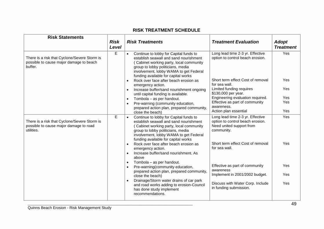
RISK TREATMENT SCHEDULE
Risk Statements Risk Level
Risk Treatments Treatment Evaluation Adopt Treatment
There is a risk that Cyclone/Severe Storm is possible to cause major damage to beach buffer.
E Continue to lobby for Capital funds to establish seawall and sand nourishment ( Cabinet working party, local community group to lobby politicians, media involvement, lobby WAMA to get Federal funding available for capital works
Rock over face after beach erosion as emergency action.
Increase buffer/sand nourishment ongoing until capital funding is available.
Tombola – as per handout.
Pre-warning (community education, prepared action plan, prepared community, close the beach)
Long lead time 2-3 yr. Effective option to control beach erosion. Short term effect Cost of removal for sea wall. Limited funding requires $130,000 per year. Engineering evaluation required. Effective as part of community awareness. Action plan essential
Yes
Yes
Yes
Yes Yes
Yes
There is a risk that Cyclone/Severe Storm is possible to cause major damage to road utilities.
E Continue to lobby for Capital funds to establish seawall and sand nourishment ( Cabinet working party, local community group to lobby politicians, media involvement, lobby WAMA to get Federal funding available for capital works
Rock over face after beach erosion as emergency action.
Increase buffer/sand nourishment. As above
Tombola – as per handout.
Pre-warning(community education, prepared action plan, prepared community, close the beach)
Drainage/Storm water drains of car park and road works adding to erosion-Council has done study implement recommendations.
Long lead time 2-3 yr. Effective option to control beach erosion. Need united support from community.
Short term effect Cost of removal for sea wall.
Effective as part of community awareness Implement in 2001/2002 budget. Discuss with Water Corp. Include in funding submission.
Yes
Yes
Yes
Yes
Yes

_____________________________________________________________________________ Quinns Beach Erosion - Risk Management Study
50
Sewage to be installed down centre of Ocean Drive this will add to utilities at risk – discuss with Water Corporation.
There is a risk that Cyclone/Severe Storm is possible to cause major damage to homes/properties.
E Continue to lobby for Capital funds to establish seawall and sand nourishment (Cabinet working party, local community group to lobby politicians, media involvement, lobby WAMA to get Federal funding available for capital works)
Rock over face after beach erosion as emergency action.
Increase buffer/sand nourishment.
Tombola – as per handout.
Pre-warning(community education, prepared action plan, prepared community, close the beach)
Emergency Management Plan
Public awareness of EMP.
Evacuation Plan.
Long lead time 2-3 yr. Effective option to control beach erosion. Need united support from community.
Short term effect Cost of removal for sea wall. Effective as part of community awareness Part of Consultants report Effective Essential
Yes
Yes
Yes
Yes Yes Yes
There is a risk that Cyclone/Severe Storm is possible to cause major damage to toilets/surf club and car park.
E Continue to lobby for Capital funds to establish seawall and sand nourishment (Cabinet working party, local community group to lobby politicians, media involvement, lobby WAMA to get Federal funding available for capital works)
Rock over face after beach erosion as emergency action.
Increase buffer/sand nourishment.
Tombola – as per handout.
Pre-warning(community education, prepared action plan, prepared community, close the beach)
Close access to car park when unsafe.
Stormwater/Drainage.
Temporary relocation for surf club as it still needs to operate. Surf club has an
Long lead time 2-3 yr. Effective option to control beach erosion. Need united support from community.
Short term effect Cost of removal for sea wall.
Effective as part of community awareness Effective Suitable accommodation to be found.
Yes
Yes
Yes
Yes
Yes

_____________________________________________________________________________ Quinns Beach Erosion - Risk Management Study
51
evacuation plan, copy to be given to Bill Harris.
Cleanup operation system for toilets if they become damaged as it will be a health risk.
Relocate toilets.
Cleanup bitumen car park after erosion damage.
Lighting to car park to be isolated, relocate light pole near beach in car park.
Essential. Cost suitable site available? Essential safety of public Essential Safety of Public
Yes
No Yes
Yes
There is a risk that Cyclone/Severe Storm is possible to cause major damage to lifestyle and psychological well being.
E Continue to lobby for Capital funds to establish seawall and sand nourishment
(Cabinet working party, local community group to lobby politicians, media involvement, lobby WAMA to get Federal funding available for capital works)
Rock over face after beach erosion as emergency action.
Increase buffer/sand nourishment.
Tombola – as per handout.
Pre-warning(community education, prepared action plan, prepared community, close the beach)
Counseling services to be available to effected residents.
Recovery plan of EMP to be implemented.
Long lead time 2-3 yr. Effective option to control beach erosion. Need united support from community.
Short term effect Cost of removal for sea wall.
Effective as part of community awareness Part of Recovery Plan Essential
Yes
Yes
Yes
Yes
Yes
There is a risk that Cyclone/Severe Storm is possible to cause major damage to property values.
E
Continue to lobby for Capital funds to establish seawall and sand nourishment (Cabinet working party, local community group to lobby politicians, media involvement, lobby WAMA to get Federal funding available for capital works)
Rock over face after beach erosion as emergency action.
Increase buffer/sand nourishment.
Long lead time 2-3 yr. Effective option to control beach erosion. Need united support from community.
Short term effect Cost of removal for sea wall.
Yes
Yes

_____________________________________________________________________________ Quinns Beach Erosion - Risk Management Study
52
Tombola – as per handout.
Pre-warning(community education, prepared action plan, prepared community, close the beach)
Educate public what actions are being implemented by Council.
Develop an ongoing communication plan to media to keep community aware of progress.
Effective as part of community awareness
Effective Effective
Yes
Yes
Yes
There is a risk that Erosion Scarp is possible to cause major damage to Tourists and or General Public.
E Warning Signs to be erected.
Regular monitoring of beach by ranger services to identify problem areas and enforcement of warnings.
Control access to the beach. Fence off affected areas. Determine action on high steep scarp.
Bore casing sticking up out of the ground on the beach Council to remove.
Educate public – Council has cliff hazard brochure include beach scarp info send to Quinns residents.
Essential for Public Safety. Establish monitoring criteria and action plan. Implement action plan. Essential for public safety. Essential for public Safety
Yes Yes
Yes
Yes
Yes

_____________________________________________________________________________ Quinns Beach Erosion - Risk Management Study
53
RISK TREATMENT SCHEDULE AND PLAN
Risk Statements
Risk Level
Risk Treatments Responsibility for Implementation
Timetable Monitoring
There is a risk that Cyclone/Severe Storm is possible to cause major damage to beach buffer.
E
Continue to lobby for Capital funds to establish seawall and sand nourishment (Cabinet working party, local community group to lobby politicians, media involvement, lobby WAMA to get Federal funding available for capital works
Rock over face after beach erosion as emergency action.
Increase buffer/sand nourishment ongoing until capital funding is available.
Tombola – as per handout.
Pre-warning (community education, prepared action plan, prepared community, close the beach)
City of Wanneroo City of Wanneroo City of Wanneroo City of Wanneroo & M P Rogers & Assoc. City of Wanneroo
By September 2001 submission to Minister When emergency occurs. Contract for supply pre-arranged. Budget allocation 2002/03 By August 2001 By April 2002, public information sessions.
Response from Minister feedback to community groups. Community groups to lobby. Contract in place & review each year by 30 April Monitor Erosion Annually Community & Council agree on engineering option. Community questionnaire.
There is a risk that Cyclone/Severe Storm is possible to cause major damage to road utilities.
E
Continue to lobby for Capital funds to establish seawall and sand nourishment ( Cabinet working party, local community group to lobby politicians, media involvement, lobby WAMA to get Federal funding available for capital works
Rock over face after beach erosion as emergency action.
Increase buffer/sand nourishment. As above
Tombola – as per handout.
Pre-warning(community education, prepared action plan, prepared community, close the beach)
Drainage/Storm water drains of car park and road works adding to erosion-Council
City of Wanneroo City of Wanneroo City of Wanneroo City of Wanneroo & M P Rogers & Assoc. City of Wanneroo City of Wanneroo
By September 2001 submission to Minister When emergency occurs. Contract for supply arranged. Budget allocation 2002/03 August 2001 By April 2002, public information sessions. By July 2001
Response from Minister feedback to community groups. Community groups to lobby. Contract in place & review each year by 30 April Monitor Erosion Annually Community & Council agree on engineering option. Community questionnaire Engineering works

_____________________________________________________________________________ Quinns Beach Erosion - Risk Management Study
54
has done study- implement recommendations.
Sewage to be installed down centre of Ocean Drive this will add to utilities at risk – discuss with Water Corporation.
City of Wanneroo to initiate meeting
By September 2001
implemented monitoring of water disposal Re-routed sewage from centre of road, influenced government funding for engineering solution.
There is a risk that Cyclone/Severe Storm is possible to cause major damage to homes/properties.
E
Continue to lobby for Capital funds to establish seawall and sand nourishment (Cabinet working party, local community group to lobby politicians, media involvement, lobby WAMA to get Federal funding available for capital works)
Rock over face after beach erosion as emergency action.
Increase buffer/sand nourishment.
Tombola – as per handout.
Pre-warning(community education, prepared action plan, prepared community, close the beach)
Emergency Management Plan
Public awareness of EMP.
Evacuation Plan.
City of Wanneroo City of Wanneroo City of Wanneroo City of Wanneroo & M P Rogers & Assoc. City of Wanneroo Police LEMAC Police & SES
By September 2001 submission to Minister When emergency occurs. Contract for supply pre-arranged. Budget allocation 2002/03 By August 2001 By April 2002, public information sessions. June 2001 April 2002 June 2001
Response from Minister feedback to community groups. Community groups to lobby. Contract in place & review each year by 30 April. Monitor Erosion Annually Community & Council agree on engineering option. Community questionnaire. Plan in place tested by June 2002 Part of community questionnaire. Plan in place, tested
There is a risk that Cyclone/Severe Storm is possible to cause major damage to toilets/surf club and car park.
E Continue to lobby for Capital funds to establish seawall and sand nourishment (Cabinet working party, local community group to lobby politicians, media involvement, lobby WAMA to get Federal funding available for capital works)
Rock over face after beach erosion as emergency action.
City of Wanneroo City of Wanneroo
By September 2001 submission to Minister When emergency occurs. Contract for supply pre-arranged.
Response from Minister feedback to community groups. Community groups to lobby. Contract in place & review each year by 30 April.

_____________________________________________________________________________ Quinns Beach Erosion - Risk Management Study
55
Increase buffer/sand nourishment.
Tombola – as per handout.
Pre-warning(community education, prepared action plan, prepared community, close the beach)
Close access to car park when unsafe.
Storm water/Drainage.
Temporary relocate surf club, it still needs to operate. Surf club has an evac. plan
Cleanup operation for toilets if they become damaged as it will be a health risk.
Relocate toilets-investigate new options.
Cleanup bitumen car park after erosion damage.
Lighting to car park to be isolated, relocate light pole near beach in car park.
City of Wanneroo City of Wanneroo & M P Rogers & Assoc. City of Wanneroo City of Wanneroo City of Wanneroo City of Wanneroo & Surf Club City of Wanneroo City of Wanneroo City of Wanneroo City of Wanneroo
Budget allocation 2002/03 By August 2001 By April 2002, public information sessions. When Required By July 2001 May 2002 When damage occurs May 2002 When erosion occurs July 2001
Monitor Erosion Annually Community & Council agree on engineering option. Community questionnaire. Rangers to patrol Implement engineering report Surf club relocated current building dismantled. Health section C of W to monitor. Options investigated solution included in budget. Cleanup car park open to public. Pole relocated.
There is a risk that Cyclone/Severe Storm is possible to cause major damage to lifestyle and psychological well being.
E Continue to lobby for Capital funds to establish seawall and sand nourishment (Cabinet working party, local community group to lobby politicians, media involvement, lobby WAMA to get Federal funding available for capital works)
Rock over face after beach erosion as emergency action.
Increase buffer/sand nourishment.
Tombola – as per handout
Pre-warning(community education, prepared action plan, prepared community, close the beach)
City of Wanneroo City of Wanneroo City of Wanneroo City of Wanneroo & M P Rogers & Assoc. City of Wanneroo
By September 2001 submission to Minister When emergency occurs. Contract for supply pre-arranged. Budget allocation 2002/03 By August 2001 By April 2002, public information sessions.
Response from Minister. Feedback to community groups. Community groups to lobby Contract in place & review each year by 30 April. Monitor Erosion Annually Community & Council agree on engineering option. Community questionnaire

_____________________________________________________________________________ Quinns Beach Erosion - Risk Management Study
56
Counseling services to be available to effected residents.
Recovery plan of EMP to be implemented.
Family & Children’s services. City of Wanneroo
When requested by local coordinator or City of Wanneroo. Local Emergency coordinator
Service provided to those in need. All requests deal with.
There is a risk that Cyclone/Severe Storm is possible to cause major damage to property values.
E
Continue to lobby for Capital funds to establish seawall and sand nourishment (Cabinet working party, local community group to lobby politicians, media involvement, lobby WAMA to get Federal funding available for capital works)
Rock over face after beach erosion as emergency action.
Increase buffer/sand nourishment.
Tombola – as per handout.
Pre-warning(community education, prepared action plan, prepared community, close the beach)
Educate public what actions are being implemented by Council.
Develop an ongoing communication plan to media to keep community aware of progress.
City of Wanneroo City of Wanneroo City of Wanneroo City of Wanneroo & M P Rogers & Assoc. City of Wanneroo City of Wanneroo City of Wanneroo
By September 2001 submission to Minster When emergency occurs. Contract for supply pre-arranged Budget allocation 2002/2003 By August 2001 By April 2002 public information sessions. 3-6 month updates by October 2001
Response from Minister feedback to community. Community to lobby. Contract in place & review by April each year. Monitor Erosion Annually Community & Council agree on engineering option Community questionnaire Community Questionnaire Plan in place. Community aware, Community questionnaire.
There is a risk that Erosion Scarp is possible to cause major damage to Tourists and or General Public.
E
Warning Signs to be erected.
Regular monitoring of beach by ranger services to identify problem areas and enforcement of warnings.
Control access to the beach. Fence off affected areas. Determine action on high steep scarp.
Bore casing sticking up out of the ground on the beach Council to remove.
Educate public – Council has cliff hazard brochure include beach scarp info send to Quinns residents.
City of Wanneroo City of Wanneroo City of Wanneroo City of Wanneroo City of Wanneroo
When required Weekly May-Oct When required July 2001 September 2001 include in communications plan.
Education and enforcement. Reports given to manager operation. Knock down scarp, make safe for community access. Bore casing removed, check weekly by rangers Community questionnaire

_____________________________________________________________________________ Quinns Beach Erosion - Risk Management Study
57
Appendix 3
PART 2: THREAT PLAN
QUINNS BEACH STORM/CYCLONE EROSION DAMAGE
INTRODUCTION: 1. The Quinns Beach between Quinns Road and to the north of Tapping Way
has been the subject of erosion since the 1960’s and 1970’s. In the mid 1990’s there were several stormy winters and in 1996 the storm erosion of the southern section was severe. Quinns Beach is subject to the effects of: a) Severe winter storms between April and November. b) Dissipating tropical cyclones between November and April. c) The inability to complete the recommended beach nourishment and
construction of a sea wall. 2. It is likely that with gale force winds affecting Quinns Beach there is a
likelihood that other storm damage will occur within the City of Wanneroo and City of Joondalup.
IDENTIFIED RISKS
3. Severe storms/tropical cyclones can produce some or all of the following
risks: a) Erosion to beach and sand dunes. b) Erosion causing damage to the Caravan Park (Quinns Road, Ocean
Drive junction). c) Erosion causing damage to car park, power pole, public toilets and surf
club in the northern section of the beach. d) Ocean Drive and the public utilities on the eastern side of Ocean Drive
(ie. Power, gas, water, telephone and road drainage). e) Damage to houses and commercial businesses along Ocean Drive.
4. A detailed Risk Analysis, Risk Schedule and Risk Plan is contained in the
Quinns Beach – Erosion Risk Management Study July 2001.

_____________________________________________________________________________ Quinns Beach Erosion - Risk Management Study
58
OPERATIONAL SEQUENCE
ALERT 5. To be read in conjunction with Annex D to Part 1 of the Local Emergency
Management Plan May 2001.
The Fire and Emergency Services Authority – State Emergency Service will daily review weather forecasts issued by the Bureau of Meteorology. When forecasts of gale warnings or strong winds from the northwest through to the southwest being critical (gale warnings is wind speeds of 34-47 knots). This information will be disseminated to: a) Police Emergency Management Officer, Joondalup Police Station who will
inturn advise b) the City of Wanneroo c) Police Station Clarkson d) Family & Children’s Services.
STANDBY
6. Is declared when the Local Emergency Coordinator considers that the implementation of the Local Emergency Plan is imminent. a) The Local Emergency Coordinator puts Wanneroo Operations
Coordination Centre (Part 1 Section 6.8) on standby. b) City of Wanneroo to put staff on standby to operate the Wanneroo
Operations Coordination Centre. c) The Wanneroo State Emergency Service (WSES) to put crews on
standby. d) Police at Joondalup and Clarkson are to be placed on standby. e) FESA – WASES is a Hazard Management Authority and the operational
structure at Diagram 1 is to be implemented if the incident goes to call out stage.
f) Local Emergency Coordinator and Hazard Management Authority to review potential erosion damage.
g) Quinns Beach Operational Centre at Gumblossom Community Centre to be placed on standby. Hazard Management Authority (FESA – WASES) to designate people to key positions in incident structure as per diagram 1.
h) Police and the City of Wanneroo monitoring sea conditions at Quinns Beach.
i) PC Cops to advise residents of gale warning, the phone number of the Wanneroo Operation Coordination Centre and that Police and/or City of Wanneroo are on site monitoring sea conditions.
j) Test communication systems between key points in the management structure Diagram 1.

_____________________________________________________________________________ Quinns Beach Erosion - Risk Management Study
59
CALLOUT
7. Declared by the Local Emergency Coordinator following the arrival of gale force winds or advised by the Bureau of Meteorology that gale force wind are imminent. a) Operational structure as in Diagram 1 implemented. FESA-WASES
Hazard Management Authority is controller located at the WOCC. b) Wanneroo Operation Coordination Centre (WOCC) and Gumblossom
Community Operation Centre are activated. c) Sitreps starting to flow from the field and Gumblossom Community
Centre to the WOCC. d) WOCC to co-ordinate with the media, media releases and public
information. e) PC Cops to advise residents that WOCC and Gumblossom Community
Operations Centre are active and phone contact for residents to report damage.
f) HMA is to fully brief Local Recovery Officer and Local Emergency Coordinator at all stages of the incident.
STAND DOWN
8. Declared by the Local Emergency Coordinator and the Hazard Management Authority Incident Controller when it is considered those emergency arrangements are no longer applicable. a) Hazard Management Authority and Local Emergency Coordinator to
liaise with all agencies to determine when stand down is appropriate. b) FESA-WASES to ensure that City of Wanneroo has recovery plan
implemented, structure in place and handover completed. c) HMA to arrange debriefing timetable. d) HMA to ensure residents are aware of stand down and recovery
arrangements in place using PC Cops or City of Wanneroo Police, WSES personnel to door knock.
CONTROL AND COORDINATION CENTRES
9. The local Operations Coordination Centre will be where the overall Incident Management Team and HMA (FESA-WASES) will be located. It is likely that with gale force winds affecting Quinns Beach there is also a likelihood that other storm damage will occur within the City of Wanneroo and City of Joondalup. The Incident Management Team and structure as in Diagram 1 can deal with the Quinns Beach incident as well as other incidents within the Cities of Wanneroo and Joondalup.
10. A Quinns Beach Operations and Management Team will be located at the
Gumblossom Community Centre to specifically co-ordinate operations for the Quinns Beach incident and other incidents within the Quinns Rock/Mindarie Key area.

_____________________________________________________________________________ Quinns Beach Erosion - Risk Management Study
60
AGENCY’S RESPONSIBILITIES
11. The table below explains the agency responsibilities, key tasks for the incidents and the functions as described in the Quinns Beach Operation Structure Diagram 1.
Responsibilities Actions /Tasks Functions of Agencies
PropertyLife/Lifestyle
Local Gov't/Police /SES Warning & Monitoring LOCC
Pre- Impact
SES/ Police/Owners & C of W Move caravans & Equipment Recovery of Property
SES/ Police/Owners & C of W Move People Evacuation Action
SES/ Police/Owners & C of W Registration for Evacuation Evacuation Action
Post Impact
LG/SES/Police/Lifelines/Owners Services Lifelines
LG/SES/Police/Lifelines/Owners Evacuation & Services Evacuation Actions Lifelines
LG/SES/Police/Lifelines/Owners Information/communication Quinns IMT
Owners to another caravan park Relocation of caravans &
Equipment to another site
Recovery/Restoration or Property
F&CS-Residents Relocation People to Evac Centre Evacuation Action
F&CS/ EDWA Provide emotional First Aid Rescue & Medical
Owners/SES Recovery of caravans & vehicles Recovery/Restoration
Owners/LG Health issues of toilets Lifelines
Owners/LG Safer citizens Security of property Traffic & Security
SES/LG Special vehicles Rescue/Medical
FESA/HEALTH respectively Rescue & Medical Rescue/Medical
Police Coronial inquiry Traffic & Security
Police/LG Return & Restoration Return & Restoration
Police Traffic & Crowd Control Traffic & Security
LG Reserve areas crowd control Traffic & Security
Owners/LG/RSPCA Community animals/pets Evacuation
LG/Police/SES Signage. Traffic & Security
LG Erosion Scarp make safe Erosion Actions

_____________________________________________________________________________ Quinns Beach Erosion - Risk Management Study
61
Quinns Beach Emergency Operations Structure HMA - Operational Co-ord
Centre
Regional/District Level
HMA (FESA/SES)
Operational Co-ord. Centre
Local Level – City of Wanneroo
Incident Management Team
Logistics
Planning
Finance
City of Wanneroo
Recovery
Coordinator
Coordination of Support
Functions
- Functional Coordinators
- Agency Liaison Officers - Media Liaison Officer.
Quinns
Incident Management Team
Quinns Community Centre
Support (as required)
- Welfare
- Medical
- Health
- Lifelines - City of Wanneroo
Other IMT
Responsible for other Incidents
Evacuation
Actions Erosion Actions Traffic & Security Rescue/Medical Recovery/Restoration
of Property
Lifelines
Actions
Recovery
Quinns
Beach Incident
Recovery
Other
Incidents
Strategic level management within City of
Wanneroo
Combat/tactical
level management

Appendix 4 Evacuation Plan Quinns Beach
EVACUATION PLAN QUINNS BEACH
CITY OF WANNEROO
Scope of Evacuation: Caravan Park, Cnr Quinns Road & Ocean Drive Residents along Ocean Drive between Quinns Rd & Tapping Way.
OPERATIONAL SEQUENCE
Alert: Weather forecast received by WASES, Belmont and disseminated to: Police EMO Joondalup Police Station ph: 9400 0952 mobile: 0416
077 237 who would in turn advise: City of Wanneroo, City of Joondalup Police Clarkson Family & Children Services. Other Actions: The Local Emergency Coordinator would put Wanneroo Emergency
Coordination Center on Standby. Use PC Cops and/or Police/Wanneroo SES to door knock to advise
residents of Ocean Drive and the caravan park of approaching storm and potential evacuation.
Phone numbers are listed in Annex B to Part 1 of Local Emergency Management Plan.
Standby: Local Emergency Coordinator located at Wanneroo Emergency
Coordination Centre (WECC). Local Emergency Coordinator (LEC) & Hazard Management Authority
(HMA) reviewing potential erosion damage. Clarkson Police at Quinns Beach providing sitrep back to Police at LEC. Advise residents of probability of evacuation using PC Cops and/or
Police/WSES through a door knock. City of Wanneroo & Family & Children’s Services activating Community
Evacuation Centre at Gumblossom Road. Residents to provide for pets.

_______________________________________________________________________ Quinns Beach Erosion - Risk Management Study 63
Callout:
Family & Children’s Services and City of Wanneroo advised of Evacuation
in progress. WASES to assist Police to advise residents to evacuate to Evacuation
Centre at Gumblossom and to register before leaving the area. Residents are to advise where they will locate themselves during storm ie. At evacuation centre or at friend or relatives.
Quinns IMT to support evacuation teams with resources where possible. Keep WECC informed of progress. Advise recovery Coordinator of evacuation as call out stage. Advise Police & City of Wanneroo of requirement for security function to
residents and caravan park property. Police Safer City Program may be able to assist the police in the security function.
WECC advise media of Evacuation and contact number for general public inquiring of the whereabouts and welfare of the evacuees.
WECC to keep Joondalup Police Duty Officer informed who will in turn inform District Duty Officer.
Organise transport for evacuees from Evacuation Centre to extended accommodation centres.
Traffic Police response to implement traffic plan to assist in the Evacuation of residents from the Caravan Park and Ocean Drive.
Family & Children’s Services and City of Wanneroo to deal with residents pets.
Assembly: Register evacuees. Determine who is staying at Evacuation Centre and who is going to friends
or private accommodation. Determine if medical attention is required. Determine if Counseling is required. Provide food and accommodation (temporary 1-2 hours or extended) Transport evacuees to extended accommodation. Accommodate: Provide food and accommodation and arrange activities for evacuees. Provide information about the incident. Provide information on likely return timeframe. Provide communication to/from friends and relations at the
accommodation centre.

_______________________________________________________________________ Quinns Beach Erosion - Risk Management Study 64
Return:
Register arrival at Evacuation Centre Provide contact for further counselling. Police implementing traffic plan to enable evacuees to return home. Police/City of Wanneroo to stand down community security as residents
return home. Family & Children’s Services and City of Wanneroo to maintain recovery
plan. Family & Children’s Services and City of Wanneroo to be proactive
advising residents of recovery issues and how they can seek assistance and help.

_______________________________________________________________________ Quinns Beach Erosion - Risk Management Study 65
Appendix 5 Minutes of Public Meeting July 2001
City of Wanneroo
Risk Management Study into Erosion at Quinns Beach
Public Meeting
Thursday 26th July 2001
Gumblossom Community Centre.
Meeting Commenced at 1905hrs
Phil Calley, Manager Operational Services, City of Wanneroo who welcomed everyone to the meeting and thanked them for their attendance, opened the meeting. Mr. Calley went onto say that the City of Wanneroo is currently undertaking a mitigation strategy into the Quinns Beach Erosion problem. A consulting firm FirePlan WA had been appointed to undertake this study. As part of the study a full day workshop was held in the City of Wanneroo Civic Administration Centre on 18th May 2001. At this workshop risks associated with the Quinns Beach erosion problem were analysed and discussed and the key management strategies identified. These strategies have been analysed by the consultant and a draft mitigation strategy report has now been prepared. Part of the project is to discuss the work and the findings with the community and this public consultation forum has been organised for this purpose. Mr. Mick Rogers from M P Rogers & Associates gave a presentation on the: -
History of Erosion at Quinns Beach
The recommended mitigation actions for the North and South flank of Quinns Beach.
The Critical Events leading to the Activation of Mitigation Strategies.
Monitoring and Emergency Response works.
Set back distances for future development of the northern flank. Mr. Bill Harris from FirePlan WA gave a presentation on the: -
An overview of the representatives who attended the Risk Management Workshop in May.
A summary of the Mitigation Strategies contained in the draft report.
A summary of the Emergency Management Plan including:-
_______________________________________________________________________ Quinns Beach Erosion - Risk Management Study 66
Operational Support Plan.
Command Structure.
Evacuation Plan.
Evacuation Centre.
It was emphasised that the Emergency Management Plan would only be implemented if there were a probability of Ocean Drive being affected by erosion from a severe storm or cyclone.
Mr. Harris made comment for the community to support the City of Wanneroo efforts of obtaining capital funding for construction of a sea wall supplemented with sand nourishment. It is unlikely Government financial support would be given to a project that the Community and the City of Wanneroo did not agree on. An example of this was a recent $7 Million beach erosion project in Bunbury where funding had been allocated but was withdrawn because of lack of support by the community for the Local Governments option.
The meeting was then opened to questions from the floor
Concerns were raised from the floor of the meeting about the lack of capital works funding required for the building of the sea wall and sanding nourishment. The Mayor Jon Kelly said the Council had been seeking $1.2 M in funding from the State Government to build the sea wall and sand nourishment option, but Council had not been successful at this time. Concerns were expressed that local input had not been obtained into which option the community supported and why weren’t groynes considered instead of a sea wall. Mick Rogers responded that during the preparation of the Quinns Beach Coastal Protection Works reports in September 1999 these reports where discussed in this room at a public forum similar to tonight’s. Mick Rogers in response to a query from the floor advised that the seawall will require maintenance in 10 years time. Mayor Jon Kelly said that the design of the sea wall and other options would be put on display for two weeks at the Gumblossom Community Centre and that copies of the Quinns Beach Coastal Protection Works reports were in the City’s Mobile Library. Copies would be made available to people if they contacted Harminder Singh at the City of Wanneroo offices. Concerns were also expressed that the future population will hold the City of Wanneroo and the State Government accountable for the erosion at Quinns Beach and the damage to community and private property. The beach is a safe beach to swim in with no rips and no sharks. With the increase in

_______________________________________________________________________ Quinns Beach Erosion - Risk Management Study 67
population in the surrounding suburbs Quinns beach will become an important regional beach
Mayor Jon Kelly reiterated that Council has undertaken all steps it possibly could and did not have the money within their budget to fund the Capital works but said that they would continue to fund the sand nourishment of the beach as they had been doing over the past 4years Ms Diane Guise MLA for Wanneroo said that she had been working with the City of Wanneroo in a concerted effort to secure capital works funding in the next State Government Budget. Ms Guise was confident that she would get some funding which may be spread over two financial years. Ms Guise also said that the community needed to support the Councils preferred option otherwise it could jeopadise future Government funding. Mayor Jon Kelly also advised that in response to tonight’s meeting, plans depicting details of the seawall and sand nourishment will be sent by mail to all the community participants of tonight’s meeting. He also advised that these plans would be displayed in the Gumblossom Community Centre for public viewing Mayor Jon Kelly thanked everyone for coming tonight and thanked everyone for there input in tonight’s’ meeting. Meeting Closed at 9.00pm.