Proposed Recommendations of the West Virginia Formulation Council Subcommittee Sean Litteral,...
13
Proposed Recommendations Proposed Recommendations of the of the West Virginia Formulation West Virginia Formulation Council Subcommittee Council Subcommittee Sean Litteral, Chairman Sean Litteral, Chairman West Virginia Department of West Virginia Department of Transportation Transportation GIS Manager 1 GIS Manager 1
-
Upload
gilbert-davis -
Category
Documents
-
view
216 -
download
0
Transcript of Proposed Recommendations of the West Virginia Formulation Council Subcommittee Sean Litteral,...

Proposed RecommendationsProposed Recommendationsof the of the West Virginia Formulation West Virginia Formulation Council SubcommitteeCouncil Subcommittee
Sean Litteral, ChairmanSean Litteral, ChairmanWest Virginia Department of West Virginia Department of Transportation Transportation GIS Manager 1GIS Manager 1

HistoryHistory
• On November 9th 2005 90 GIS professionals discussed a new GIS Coordination Council.
• A committee was identified to explore implementing methods and organizational structure.
• Committee met 5 times to work on issues and vote on recommendations.
• Results and meeting minutes are available on-line through the WV GIS Tech Center (GIS News).

Committee MembersCommittee Members
L_NAME F_NAME
ORGANIZATOIN SECTOR E-MAIL
Adkins JD Cabell County Assessors Office Local Govt. [email protected]
Bauch Bruce U.S. Geological Survey Federal [email protected]
Donaldson Kurt WV GIS Technical Center, WVU State [email protected]
Elkhansa Hussein Division of Highways State [email protected]
Elmes Greg West Virginia University Education [email protected]
Evans Larry Dept. of Environmental Protection State [email protected]
Griffith Andrea Semaphore Hill Associates, LLC Private [email protected]
Litteral Sean Rahall Transportation Institute, State [email protected]
Leonard Jamie Marshall University Education [email protected]
Mazgaj Joe Division of Homeland Security – Emergency Management
State [email protected]
Neidig Craig State GIS Coordinator State [email protected]
Inglis-Smith Chandra Rahall Transportation Institute, [email protected]
Thaxton Rex Mountain CAD Corp. Private [email protected]


Key Elements of the Plan• Provides a mechanism for the Geospatial
Community to work with the State GIS Coordinator.
• Creates an organization to Champion GIS.• Policies• Standards• Legislation• Conferences• Advocacy Educate decision makers and political leadersEducate decision makers and political leaders
• Make GIS part of everyday state business

MISSION
To promote and support geospatial professionals in the efficient use of sharing geospatial information and related resources throughout the state of West Virginia.
RECOMMENDED MEMBERSHIP CRITERIA
Anyone who has an interest in geospatial technology.
To be a voting member, must pay membership fee of $50 for an individual, $20 for a student.
WEST VIRGINIA ASSOCIATION OF GEOSPATIAL PROFESSIONALS

The board shall have supervision, control, and direction of the affairs and funds of the WVAGP, and shall carry out the policies or changes therein within the limits of the bylaws. The board may elect delegates to a executive board of officers, staff, and committees as it deems necessary for the administration of the affairs of the WVAGP. •The Board membership shall be composed of 11 voting members, with one non-voting member comprised of the State GIS Coordinator.
•Composition of Board as follows:•3 State, 2 education, 2 local, 1 federal, 2 private, 1 at-large.
•The Board member are elected every 2 years.
•The Board will be planners!
Board of Directors

Board will elect four of its members as the Executive Committee, Comprised of a Chairman, Co-Chair, Treasurer, and Secretary.
There will be only three voting members on the Executive Committee.
The three voting members will be the Chairman, Co-Chair and Treasurer.
Two year term for board members/executive committee.
Primary BenefitSmaller group making it easier to meet.
Executive Committee

•State GIS Coordinator will be lateral to proposed 11 member board and will advocate its actions through the administration.
•Placement of Coordinator should be under CTO in the State IT Department.
GIS Coordinator

State GIS Coordiator Duties in Relationship to WVAGP Duties
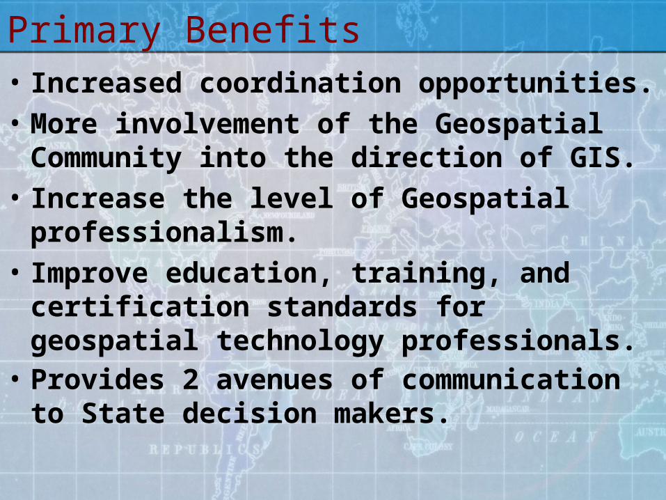
Primary Benefits• Increased coordination opportunities.• More involvement of the Geospatial
Community into the direction of GIS.• Increase the level of Geospatial
professionalism. • Improve education, training, and
certification standards for geospatial technology professionals.
• Provides 2 avenues of communication to State decision makers.

What the next step?
• Establish acceptance by the Geospatial Community.
• Development of a Strategic Plan.• Establish the organization.• Nominate and Elect Officers.• Draft and approve Charter and
Bylaws.• Establish ties to Executive and
Legislative branches.

Reminder
• Please fill out the voting Ballot after the end of discussions.
• You can vote by paper, email or online.
• Deadline June 2.


![STATE OF WEST VIRGINIA AUDIT REPORT OF WEST VIRGINIA STATE ... · WEST VIRGINIA STATE POLICE INTRODUCTION The West Virginia State Police [State Police] was created in 1919 by Chapter](https://static.fdocuments.in/doc/165x107/5e268e4aa6c417777a2293bb/state-of-west-virginia-audit-report-of-west-virginia-state-west-virginia-state.jpg)