PROPOSAL LU 0701-2015: A WHITE PAPER A NEW …
18
1| Solutions for QueensWay PROPOSAL LU 0701-2015: A WHITE PAPER A NEW OPPORTUNITY TO TRANSFORM A BLIGHTED, 3.5 MILE STRETCH OF ABAONDONED RAILWAY IN CENTRAL QUEENS INTO A FAMILY- FRIENDLY LINEAR PARK AND CULTURAL GREENWAY CALLED THE QUEENSWAY. Austin Fischer Jessamyn Sutton Juliana Emmanuelli Sarah Borodach April 27, 2015 Submitted to: New York City Committee for Land Use The authors rely heavily upon a review of the Manhattan Highline, as well as upon prior research projects supported by the Committee for Land Use LU 0503-2005, C 050163 PCM, §197-c, §197-d. The opinions expressed in this report do not represent the official position of the NYC Council, Committee for Land Use. Table of Contents ABSTRACT 2 INTRODUCTION 2 Recreational and Academic Use of QueensWay 3 Privacy for Adjacent Homes 4 QueensWay as an Ideal Public Space 5 BACKGROUND 5 Urban Planning and Land Use 6 Funding for Manhattan Highline 6 Preliminary Funding for Cost and Funding 7 Queens Community 8 Zoning Regulation 9 Community Outlet 10 PROPOSAL 10 Beautification of the Rockaway Beach Branch Line 10 Partnership of Trust for Public Land and Friends of QueensWay 11 Planning for engagement 11 Community Involvement and Engaging Community Involvement 12 Environmental impact 13 Better Usage of Space 13 Threats to the Mission of the Project 14 Plausibility through Proposed Project Funding 15 CONCLUSION 15 END NOTES 16
Transcript of PROPOSAL LU 0701-2015: A WHITE PAPER A NEW …

1| Solutions for QueensWay
PROPOSAL LU 0701-2015: A WHITE PAPER
A NEW OPPORTUNITY TO TRANSFORM A BLIGHTED, 3.5 MILE STRETCH OF
ABAONDONED RAILWAY IN CENTRAL QUEENS INTO A FAMILY- FRIENDLY LINEAR
PARK AND CULTURAL GREENWAY CALLED THE QUEENSWAY.
Austin Fischer
Jessamyn Sutton
Juliana Emmanuelli
Sarah Borodach
April 27, 2015
Submitted to:
New York City Committee for Land Use
The authors rely heavily upon a review of the Manhattan Highline, as well as upon prior research
projects supported by the Committee for Land Use LU 0503-2005, C 050163 PCM, §197-c, §197-d.
The opinions expressed in this report do not represent the official position of the NYC Council,
Committee for Land Use.
Table of Contents
ABSTRACT 2
INTRODUCTION 2
Recreational and Academic Use of QueensWay 3
Privacy for Adjacent Homes 4
QueensWay as an Ideal Public Space 5
BACKGROUND 5
Urban Planning and Land Use 6
Funding for Manhattan Highline 6
Preliminary Funding for Cost and Funding 7
Queens Community 8
Zoning Regulation 9
Community Outlet 10
PROPOSAL 10
Beautification of the Rockaway Beach Branch Line 10
Partnership of Trust for Public Land and Friends of QueensWay 11
Planning for engagement 11
Community Involvement and Engaging Community Involvement 12
Environmental impact 13
Better Usage of Space 13
Threats to the Mission of the Project 14
Plausibility through Proposed Project Funding 15
CONCLUSION 15
END NOTES 16

2| Solutions for QueensWay
ABSTRACT
The QueensWay is an initiative to transform an abandoned railroad line from Rego Park to Ozone
Park, and in doing so enhance the economic, social and cultural dynamic of the neighborhood. After closely
examining the benefits and flaws of the Manhattan Highline comparatively with the plan for the QueensWay,
it is clear that the Queensway has the potential to positively impact the neighborhoods it touches. By
focusing on community input and engagement, this project can avoid the issues of gentrification and
displacement of current residents. In celebrating the diversity of the varying neighborhoods along the
QueensWay as well as incorporating the different concerns of the neighborhoods, the project has become
community owned. The goal of the QueensWay is to return to the main focus of public spaces, to promote
the enjoyment and betterment of the people that live in surrounding neighborhoods.
INTRODUCTION Following over 50 years of ceased service, the trust for public land use and Friends of the
QueensWay are working towards making the Rockaway Beach Branch (RBB) rail line beneficial for the
community by converting this elevated rail structure into a park called the QueensWay.
It has many progressive plans including improving connections + neighborhoods, ecology + education, play
+ health, safety + comfort, culture + economic development, and care + stewardship1.
This cultural greenway will act as a connector for neighborhoods, connecting Jamaica Bay Greenway
to north Flushing Meadows-Corona Park as well as Victory Field to Forest Park trails. In addition to
connecting these parks the QueensWay connects Rego Park, Forest Hills, Richmond Hill, Glendale,
Woodhaven, and Ozone Park.
2 Figure 1: Site of Proposed QueensWay
Underneath the QueensWay there are roads that have been called the second deadliest in New York City.
There are 12 schools and two little league field complexes whose access requires crossing these deadly
streets.3 The QueensWay provides safer routes to these destinations for children and adults to travel by foot
or bike that in the past were only travelable by car4.
The QueensWay is a multi-faceted community endeavor to transform the once advantageous RBB
rail line that has become inoperable into an outdoor cultural greenway. See figure 1

3| Solutions for QueensWay
Recreational and Academic Use of the QueensWay Ecologically and educationally the QueensWay will transform an inaccessible, trash-strewn site into
an arboretum-like setting and active learning environment. Early settlers of the region used deposited rocks
and sand as the ridgeline to mark territory. The QueensWay attempts to replicate its roots by using similar
deposited remnant for paths referred to as “terminal moraine.” Native species of plants and birds have been
driven out over time by invasive species. Ecologists plan to up-root invasive species, returning the park to its
native splendor. The QueensWay is aligned with the Atlantic Flyway, the main East Coast migration route
for birds. The area presently does not exemplify its potential for biodiversity, but with enhancement of the
native plant biodiversity the QueensWay plans, during migration season, for a positive increase in
educational opportunities to observe different species of birds5.
6 Figure 2: Site of QueensWay
In respect to play and health, the QueensWay includes recreational use for all interests including a
skate park, biking and jogging paths, adventure playgrounds, spaces for bocce, chess and game tables, a
multi-use pavilion and much more. Utilizing this space, people who live within a mile of the park can
increase their exercise by almost 40%.7 The National Institute of Health has documented that living near a
park produces clear health benefits. Under PLAN NYC every New Yorker should live within 10-minute
walk to a park, and many residents in this section of Queens do not meet this requirement. For the citizens
near central Queens who live near Forest park, the QueensWay may not have as obvious a benefit, but for the
citizens particularly in Richmond Hill and Ozone Park, the QueensWay will produce obvious health
benefits8.
9 Figure 3: Ecological Spaces10

4| Solutions for QueensWay
Privacy for Adjacent Homes In regards to safety and comfort, the QueensWay has planned the park to meet the needs of people of
all ages and abilities; including ramped entries, comfort stations, benches and four main activity areas. The
paths created will purposefully avoid pedestrian and biker conflicts and include access for emergency
vehicles. Being central in Queens, the park has plans of avoiding confrontation and providing privacy for
adjacent homes11.
12 Figure 4: Construction Planning
The pathways that run by the environs of the park have vegetated buffers, secure fencing, and are
excavated to be lower than the homes so that QueensWay users do not have any visual connection with
adjacent homes as the QueensWay leveling is lower than the homes, protecting the homes’ privacy. In
addition, each of the four activity areas is decisively not located near any homes. Just as there are barriers
from paths to homes, there is a lighting barrier for the comfort of adjacent homes. Low lighting is located
near the residential areas as to not disturb neighbors and high light levels are located towards in the main
activity area sand entrances. To ensure safety and security, the park has gates at all entrances and will close
as dusk, excluding certain winter months when it will close slightly later for commuters. NYC Parks “Police
Enforcement Patrol” officers will patrol on bicycles and will be empowered to issue summonses and make
arrests while coordinating with local police.
The QueensWay as an Ideal Public Space An increasingly concerning issue in NYC is gentrification. Gentrification threatens the current social
and economic landscape of the city and is integral in deciding future social sustainability in NYC. As the
book Gentrification describes, gentrification is caused by the “reinvestment of capital in the urban center”13.
This definition in itself is extremely concerning as it lays out any improvement in urban life or urban
beautification as a catalyst for gentrification. When discussing transforming out-of-use infrastructure into a
functional public space, the Highline in Chelsea serves as an effective predecessor. The Highline was an out
of use elevated train track that was slated for demolition in 1999. Before it was transformed into a public
space, the highline was overgrown and had graffiti. Two residents of Chelsea, Joshua David and Robert
Hammond, came together to form Friends of the Highline, a group of community activists seeking to have
the tracks turned into a park. When Mayor Bloomberg came into office he backed this plan as he believed it
would increase tourism in the Chelsea area of NYC. The purpose of the Highline in Manhattan was more
focused on tourism rather than community value.
5| Solutions for QueensWay
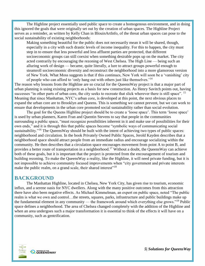
The Highline project essentially used public space to create a homogenous environment, and in doing
this ignored the goals that were originally set out by the creation of urban spaces. The Highline Project
serves as a reminder, as written by Kelly Chan in BlouinArtInfo, of the threat urban spaces can pose to the
social sustainability of existing neighborhoods:
Making something beautiful for the public does not necessarily mean it will be shared, though,
especially in a city with such drastic levels of income inequality. For this to happen, the city must
step in to ensure that less powerful and less affluent parties are protected, that different
socioeconomic groups can still coexist when something desirable pops up on the market. The city
acted contrarily by encouraging the rezoning of West Chelsea. The High Line — being such an
alluring work of design — became, quite literally, a lure to attract groups powerful enough to
steamroll socioeconomic diversity and reconstruct the neighborhood into a more glamorous version
of New York. What Moss suggests is that if this continues, New York will soon be a ‘vanishing’ city
of people who can afford to ‘only hang out with others just like themselves.’14
The reason why lessons from the Highline are so crucial for the QueensWay project is that a major part of
urban planning is using existing projects as a basis for new construction. As Henry Savitch points out, having
successes “in other parts of urban core, the city seeks to recreate that slick wherever there is still space”. 15
Meaning that since Manhattan, NYC’s urban core, is developed at this point, the next obvious places to
expand the urban core are to Brooklyn and Queens. This is something we cannot prevent, but we can work to
ensure that developments in the urban core promoted social sustainability rather than social evolution.
The goal for the Queens Highline project should be to create a ‘loose space’. This term ‘loose space’
is used by urban planners, Karen Fran and Quentin Stevens to say that people in the communities
surrounding a public space, “must recognize possibilities inherent in it and make use of possibilities for their
own ends,” and it is through this that public spaces become “symbolic ways of communicating social
sustainability.”16 The QueensWay should be built with the intent of achieving two types of public spaces:
neighborhood and circulation. In the book Privately Owned Public Spaces, Jerold Kayden describes that a
neighborhood space should attract people from an immediate radius and encourage socializing within the
community. He then describes that a circulation space encourages movement from point A to point B, and
provides a better route of transportation in a neighborhood.17 Without a doubt, the QueensWay can achieve
both of these goals, but it is important that the project is protected from the encouragement of tourism and
building rezoning. To make the QueensWay a reality, like the Highline, it will need private funding, but it is
not impossible to achieve community focused improvements when “city government and private interests
make the public realm, on a grand scale, their shared interest”18
BACKGROUND The Manhattan Highline, located in Chelsea, New York City, has given rise to tourism, economic
influx, and a serene oasis for NYC dwellers. Along with the many positive outcomes from this attraction
there have also been negative effects. As Michael Kimmelman, an expert on public space, noted “The public
realm is what we own and control…the streets, squares, parks, infrastructure and public buildings make up
the fundamental element in any community — the framework around which everything else grows.”19 Public
space defines a neighborhood. The area of Chelsea changed completely with the addition of the Highline and
when an area undergoes such a major transformation it is essential to think of the effects it will have on a
community, such as gentrification.
6| Solutions for QueensWay
Urban Planning and Land Use
According to the MCGill University Center for urban planning, urban planning is defined as a the
“technical and political process concerned with the welfare of people, control of the use of land, design of
the urban environment including transportation and communication networks, and protection and
enhancement of the natural environment.”20 In the past, urban planning has not considered such outcomes,
but with the proper urban planning, the QueensWay project can avoid such negative outcomes that have
become such pressing issue in New York City.
A focus on land use includes transforming infrastructure that is condemned into a functional public
space, such as the Highline in Chelsea. The Highline was an elevated train track that is now a public park.
Before the tracks were converted into public space there were many issues surrounding the area. Two
resident of Chelsea Joshua David and Robert Hammond, came together to form Friends of the Highline, a
group of community activists seeking to have the tracks turned into a park. Mayor Bloomberg backed the
project because he believed it would increase tourism in Chelsea.
Funding for the Manhattan Highline
Total cost was $273.5 million
$123.2 million came from the City of New York
$20.3 million from the Federal government
$400,000 from the State of New York
$132.6 million was raised privately by the Friends of the Highline21
As is evident from above, much of the funding for the Manhattan Highline came from private
investors with a focus on developing real estate in Chelsea and returns to these investors. While development
was promoted, gentrification and rent prices were practically ignored in the legislation process; creating the
issue of displacement of the residents of Chelsea. To avoid and prevent these issues from occurring in regard
to the QueensWay, legislation will need to be enacted.
The projects that are associated with public space in New York take into account economic and
environmental factors. They tend to ignore though, the issues regarding gentrification, displacement, and
rising rent prices. This often occurs because of the loose legislation, such as zoning regulations, surrounding
the creation of these projects. The chart below displays the change in rent prices in Manhattan form before
the establishment of the Manhattan Highline to after it was built.
The increase in rent prices resulting from the Manhattan Highline will be avoided for the Queensway by instituting strict zoning legislation. See Figure 6
The QueensWay’s urban planning maps the social and economic landscape for the future of New York as laid out in PLAN NYC. This includes ensuring that thousands more people live within a 10-minute walk from a park.

7| Solutions for QueensWay
22
Figure 5: Shifts in rent pricing, West Chelsea
There is no way to prevent the expansion of neighborhoods outside of Manhattan, but there are ways
to guarantee that developments preserve and promote social sustainability, rather than social
evolution. The goal for the QueensWay should be to incorporate the lessons learned from the mistakes of the
Highline. It should be built with the intent of achieving two types of public spaces, as Jerold Kayden
describes in his book Privately Owned Public Space: The New York City Experience: neighborhood and
circulations. The neighborhood aspect should attract people from neighboring areas and circulation will
expand routes of transportation23. The QueensWay can accomplish both of these goals without gentrification
and displacement as an outcome. Efforts can be made to maintain diversity and limit development.
Preliminary Estimates of Cost and Funding
The cost estimate for constructing the QueensWay, including contingencies and design costs, are
approximately $120 million24. As of now, The Trust for Public Land, a nonprofit organization that works to
create parks and protects land for people25, has raised only $1.2 million of the $120 million26. The city itself
recently made a huge investment, of $130 million, in local parks throughout all five boroughs, deterring
funding for the QueensWay to come from the government. The cost of the park seems feasible especially
when compared to the Manhattan Highline. Unlike the Manhattan Highline, the neighborhoods surrounding
the proposed QueensWay do not have the revenues to support this project, making the target donors people
that have a connection to Queens, such as natives.
The QueensWay plan’s cost after considering the necessary construction of the existing bridges,
landscape, viaduct, bridge over the LIRR Montauk Branch line, lighting, comfort stations, playgrounds,
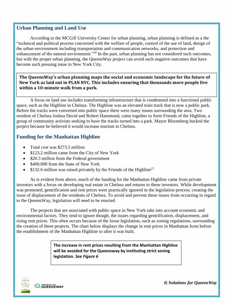
pavilions, and entry points. This has been approximated to be $120 million, $2.6 million per acre.
8| Solutions for QueensWay
27 Figure 6: Cost of funding a park
The Queensway has received funding from the State of NY Office of Parks, Recreation & Historic
Preservation, The Governor’s Regional Economic Development Council, NYC Department of
Environmental Protection, Citi Foundation, The Tiffany & Co. Foundation, the Tiger Baron Foundation, the
Booth Ferris Foundation, the Scherman Foundation and the Lily Auchincloss Foundation.28 Refer to page 14
for more information.
Queens Community
Public space is essential for the growth of urban communities, such as Queens. Queens is one of the
most populated boroughs of New York City. Transforming The Rockaway Rail Line into a park can be
extremely valuable for the Queens community, but it must be done in a way that preserves its residents.
There must be legislative measures taken in order to avoid problems that occurred with the Manhattan
Highline. These projects have heavy effects on real estate prices in the encompassing areas. Legislation has
to be instituted to protect these neighborhoods against the rising prices and unfortunate displacement of
people. Based on the outcomes of the Manhattan Highline, the QueensWay comes with a forewarning
regarding higher property values, which risks placing people who cannot afford the raised prices out of their
homes.
Queens is known for its cultural diversity. The neighborhoods surrounding the proposed area for the
QueensWay don’t hold a particular dominant ethnicity, which is very rare in New York City. Figure 7
below represents the population of Queens based on ethnicity:

9| Solutions for QueensWay
29
Figure 7: Cultural Diversity Queens
Zoning Regulations
The major defect in the legislative of the Manhattan Highline was the looseness regarding the zoning
laws. The legislation provided little regulation for the expansion opportunities, which enabled developers to
take advantage of Chelsea and cause displacement. When considering the neighborhoods surrounding the
QueensWay, it is vital to incorporate specific zoning laws in order to protect residents against development
and expansion.
In order for the diversity in Queens to endure, zoning laws will have to be instated to promote and
protect the current neighborhoods in Queens. Thus far, there are various zoning laws in place regarding the
areas surrounding the QueensWay. There are also proposed laws that are in the process of being legislated.
The aspects of these laws, specifically pertinent to the QueensWay, include:
The reinforcement of the neighborhood originality and established building patterns
Instituting a small amount of new residential and “mixeduse development” opportunities to major
passageways and locations near mass transit resources
Preventing commercial infringement into residential areas by reducing the amount of commercial
intersections and overlays30
Land prices must also be considered for the building of the QueensWay. Linear parks across the US
have been shown to increase property values for surrounding homes. The consultant team for the Friends of
the QueensWay, the nonprofit organization developing the QueensWay, estimates that home values adjacent
to the QueensWay would increase by five to seven percent over the first six years (the length of a typical
market cycle) after the park opens31. The rezoning in Queens provides a framework for orderly growth while
protecting residential character, which would most definitely need to be considered for the construction of
the QueensWay.
Community Outlet Culturally and economically, the QueensWay will act as an outlet for preserving the neighborhoods
traditions as well as bring more tourists to the neighborhood. Spaces on the QueensWay, specifically the
viaduct, will offer platforms for performances and public art. Working with the Queens Chamber of

10| Solutions for QueensWay
Commerce, the QueensWay can host seasonal food festivals at the corridors that cross the QueensWay,
highlighting the borough’s cultural cuisines. These festivals will promote tourism in Queens by having
tasting menus from local and surrounding restaurants. Based on current data concerning visits to Forest Park,
totaling approximately 900,000 visits, this study projects that the QueensWay will have approximately 1
million annual visits. Assuming this approximation is correct, we assume all visitors will spend about $7 to
$21 per visit, resulting in an increase in $2.2 million per year in local spending. This spending will
strengthen local businesses and discourage commercial businesses from coming in.32
The president and chief executive officer of the Trust for Public Land promotes the idea of the
Queens project. He says, “The Highline led to the redefinition of the neighborhoods in Manhattan, whereas
the QueensWay will be defined by the neighborhoods it passes through. Essentially, it will be a cultural
trail”33. This is the quintessence of what should be the outcome of such a project, and in constructing the
QueenWay using the community as the focal point of the project this will occur.
PROPOSAL: THE QUEENSWAY AS A BENEFICIAL SPACE FOR
COMMUNITY DEVELOPMENT
Under the Trust for Public Land, the QueensWay project can be developed as a community owned
public space. Through carefully thought out solutions and proposals, the QueenWay will not serve a similar
role as the Manhattan Highline. The people along the QueensWay as well as The Trust for Public Land will
ensure that this is a project by the community and for the community. The hopes of this proposal are to
create community beautification in a way that focuses on community engagement. Beyond this the project
will help the city to fulfill a goal under PLANNYC, ensuring that every New Yorker lives within 10 minutes
of a park. As it stands now, many citizens on the southern end of the proposed project site do not live within
10 minutes of a park. Below is a list of goals for the community as well as ways for this project to be carried
out efficiently and effectively.
Beautification of the Rockaway Beach Branch Line The existing Rockaway Beach Brand Line is characterized by homelessness, trash and drug use. The
area is overrun with un-kept vegetation, and acts as blight on the neighborhood. The goal of the QueensWay
project is to revamp the existing piece of infrastructure, and make it an asset for the community.34
35 Figure 8: The proposed transformation of the Rockaway Beach Branch Line

11| Solutions for QueensWay
Partnership of The Trust for Public Land and Friends of QueensWay The Friends of the Queensway (FQW) was founded in 2011 by residents along the former LIRR
Rockaway Beach Branch. The group dedicated itself to the conversion of an abandoned stretch of railroad
tracks to a thriving public space. Later in 2011, the group entered into a partnership with The Trust for
Public Land, the nation’s leading nonprofit organization focused on creating public spaces. The two
organizations have worked cohesively to incorporate community input into their plan for the Queensway.36
Planning by Engaging Community Involvement The Trust for Public Land is making use of the Steering Committee, a subdivision of the Friends of
the Queensway made up of community representatives. The committee incorporates residents from both the
North and South side of the Queensway. The North side is wealthier, with better access to public
spaces. The South side is less affluent than the North side.37 The Steering Committee is the voice of the
project, and the diversity of its members ensures that all of those affected by the Queensway will have a say
in its construction. Community workshops are held in all the surrounding neighborhoods to incorporate
community ideas, and many of these ideas have made it into the architectural plan. While outreach is still
being done, those both on the North and South ends of the Queensway support the development of this
park. High-School students have been incorporated into the planning, and their voices can be seen in the
planned addition of a skate park to the South end of the Queensway.38 The goal of the project is to keep the
planning as close to the community as possible.
Spaces for Events and Engagement
39 Figure 9: Distinguished event Spaces
Growth of Local Business: In partnership with the Queens Chamber of Commerce the
QueensWay will host seasonal food festivals as a way of stimulating local spending and
celebrating community diversity. See Figure 8.
As seen in figure 8, the
QueensWay will feature
special areas for events,
festivals, and restaurants.
These spaces will be used in a
way that further promotes
community building and
supports local businesses,
schools, and arts.

12| Solutions for QueensWay
a. Education
The Queensway will provide education in two ways. First, visitors will be promoted to learn about
the ecology of the area. This will mainly consist of the biodiversity of plants and animals within the
Queensway. Second, the Queensway will incorporate surrounding schools and provide them with outdoor
spaces for instruction. The goal is to have interactive, natural settings for students to learn. Four schools are
currently working with the Queensway. Specifically, the Queens Metropolitan High School is being
incorporated, and the school hopes to use the space for outdoor science classes.40
41 Figure 10: Outdoors learning space
b. Vendors
The project would ensure that only local vendors benefit from the economic developments that the
QueensWay will provide. The main focus of reaching out to local vendors is to highlight local foods and the
diversity they display of the surrounding communities. It is estimated that the Queensway will draw 1
million visits, 250,000 of which will be tourists. The spending of these visitors is approximated to draw $2.2
million in new local spending.42
Environmental Impact A secondary outcome of the Queensway will be the creation of green modes of transit. Queens is
currently very car dependent, and the addition of this park may reduce this dependence. The addition of a
safe and beautiful area to bike and walk may lead to a decrease in car usage. The Trust for Public Land
highlights that predicting trends like this is difficult, but that green infrastructure generally leads to more
environmentally conscious modes of transit.43
Is There A Better Usage of This Space?44 In various Steering Committee meetings, community meetings, and in News Publications, it has been
suggested that the space would be better used if it was revived to its original purpose: a railway. It is
undeniable that Queens could benefit from more transit but creating a subway line along the retired tracks of
the Rockaway Line is not feasible. In analyzing this alternate usage of the space the proposal will dispel any
rumors and clarify that a park is the best usage of the former railway line.
1. The MTA is suffering from a large deficit. The MTA has a 5-year plan with a 16
billion dollar deficit. The 5-year plan makes no mention of the QueensWay or creation
of a new subway line in Queens. The creation of a subway line in the space of the
proposed QueensWay would take decades. In evaluating the MTA’s 20-year capital

13| Solutions for QueensWay
plan it becomes apparent that any rail reactivation is not feasible. The 20-year capital
plan has one line that rail reactivation can be considered based on economic
feasibility. Due to the MTA’s current fiscal issues, it is highly unlikely that the MTA
would approve rail reactivation even in 20 years.
2. Rail reactivation extremely expensive and fiscally irresponsible. Despite having the
structural basis for a railway, the undertaking of creating a subway line would require
improving the infrastructure of the site. In order for rail reactivation to occur all the
overpasses along the tracks would have to be reinforced and much of the old tracks
would have to be lifted and replaced.
3. Rail reactivation would alter current residential areas, posing a threat to the
dynamics of current communities. The placement of a subway line would create a
tremendous disturbance in all the neighborhoods the line would run through. In certain
stretches of the rail there are residential areas where the end of property lines are three
or four feet from the rails. The majority of the people that live in these areas moved
after the rail was deactivated. The creation of a rail would drive down property values
as well as create a tremendous disturbance. The residents living a long the line would
have major opposition toward rail reactivation making the project even more unlikely.
4. There are other ways to provide transit that are more economically responsible and
feasible. An example of the MTA’s work towards providing more transit can be seen
in the new select bus line on Woodhaven Boulevard. This line will have its own lane
and will run frequently, providing more transit and access to areas that are currently
underserved.
Threats to the Mission of the Project The Trust for Public Land has worked to avoid the gentrification and flood of tourism that arose in
the Manhattan Highline. To combat these forces, the Trust for Public Land is aligning their project as close
to community interests as they can, by holding community workshops to gain input and involving the
community in the planning process. In addition to this, the Trust for Public Land has worked to incorporate
local businesses into the Queensway. They are gaining their funding from public institutions as well as
private contributors with a vested interest in the community.45
The Trust for Public Land defends the Queensway by stating that the location is not at all susceptible
to tourism in the way that West Chelsea is. The Trust for Public Land finds that 70% of the park usage will
come from community residents. In addition to this, the zoning in the area is not conducive to development
in the way Chelsea is, as it does not easily allow the transfer of air rights which promote the development of
large buildings. Any change in existing zoning would require the consent of the Mayor, which is unlikely to
happen. 46
The key factor in preserving the ethnic and cultural dynamic of the neighborhood will be
incorporating the same community interest that has been involved in the planning of the Queensway47. This,
along with the preservation of the existing zoning regulations, will allow the community to renovate the
The creation of a park is the best usage of the former rockaway branch line. Not only is it the most
fiscally feasible and responsible solution, but it is also a solution that can benefit the community in
the immediate future. It would not be beneficial to the residents of the community to wait 20 years
for the possibility of a subway line that would cost exponentially more and destroy residential
areas. A park will create a beautiful community owned space that will encourage community
development and engagement.
14| Solutions for QueensWay
existing abandoned railroads in a productive manner.
Plausibility Through Proposed Project Funding
The estimated cost of the QueensWay is 122 million dollars48. Funding for this project will come
from both public and private donors. The initial money for the proposal of the project came from a state
grant. The first grant of $467,000 came from Governor Cuomo’s Regional Economic Development Council
(REDC).49 This money made it possible to begin the Feasibility Study. The City of New York, additionally
contributed $140,000 under environmental and green infrastructure analysis. As of 2014 the project received
another REDC grant of $443,750.50 This money will be allocated towards the First Phase of building. As of
2014 the Trust for Public Land has raised an additional 1.5 million from donations.51 The project will
continue to apply for state grants as the state government has proven its commitment thus far to the project.52
The City of New York has made a promise to allocate funds towards the Queensway, however as it stands
now it is unclear how much money the city will provide and where the city funds will come from. There are
rumors that the money is going to come from the 130 million dollar budget of the Community Parks
Initiative, but The Trust for Public Land has heard nothing to say this is true or even a possibility.53 Lastly
The Trust for Public Land has philanthropy teams focusing on finding a few substantial private donors. The
Trust for Public Land is accepting donations, but the bulk of private money will come from a few large
donors. The project is not about private donors attempting to place alternation on the project and shift the
community focus because the people being approached are Queens natives.54 To ensure the continued
integrity of the project the private donors being sought are people from Queens, who love Queens, who made
it big, and want to see the Queens community continue to develop. All the donors must have the
understanding that this is a true community project.
CONCLUSION: Through evaluating the flaws of the Manhattan Highline, and examining the purpose of public spaces
in New York City, the Queensway can be seen as a positive contribution to NYC. The zoning problems,
concerning the development of a separate West Chelsea district that led to large-scale development are
almost completely absent in Queens. The area, while susceptible to increasing real estate values, will not face
the widespread gentrification that took place in Manhattan. The legislative climate and physical proximity of
the Queensway are not conducive to this type of change.
The Queensway will bring a variety of benefits to the surrounding neighborhoods, most namely the
transformation of a traditionally overgrown and abandoned stretch of railroad tracks into public space. The
Queensway will bring beauty and nature to the area, through the incorporation of plant and animal life. The
biodiversity of the Queensway will function in two ways, through installing beauty into the public space and
through educating visitors on the natural life of the space. Beyond beauty, the Queensway will function as a
safe mode of transportation, via walking or bike, between areas previously only accessible by bus or car.
The project is taking steps to ensure that it is a project by the community and for the community. The
Funding will come from three sources:
-The State through the Regional Economic Development Council. 910,750 dollars have
been allocated to date.
-The City. 140,000 through the city planning department but the budget from which the
rest of the funds will be allocated through remains unknown.
-Private Donors: 1.5 million has been raised to date by the Trust for Public Land. The
Trust For Public Land hopes to raise half of the cost of the project Privately.

15| Solutions for QueensWay
progression of the project from a small grassroots movement to being a major project for The Trust for
Public Land shows the nature of this project. The communities surrounding the QueensWay, despite varying
ethnicities and socioeconomic backgrounds are working together to beautify the rails in a way that will
incorporate the ideas of the people of the neighborhoods. Every aspect of this project focuses on the
community value the QueensWay will bring to this region; this includes planning, funding, education,
transportation, local businesses, and environmental impact. The way funding is being dealt with is extremely
telling to the tone of the project. By focusing on a mix of donations and private donors that are locally based,
the project will remain as owned by the community. In incorporating vendors, local businesses will grow
rather than wither and the diversity of these areas will be celebrated as well as strengthened. The park also
will meet the PLAN NYC goal to ensure that every New Yorker lives within 10 minutes of a park. The
building of the QueensWay will provide many residents with access to a park when they previously did not
have one. By including the people in the planning, it allows this space to belong to them and fit their needs
and concerns. The QueensWay, as it continues on the path of being a large-scale neighborhood project, will
serve as an example of neighborhood beautification that is owned by communities rather than real estate
interests. This study is hopeful that there will be future projects that serve to improve the neighborhood
dynamic, while preserving the cultural dynamic, through the incorporation of community voice.
1 "Home – QueensWay." QueensWay. January 1, 2015. Accessed April 26, 2015. http://thequeensway.org/
2 Ibid.
3 "Connections Neighborhoods – QueensWay." QueensWay. January 1, 2015. Accessed April 26, 2015.
http://thequeensway.org/the-plan/connections-neighborhoods/. 4 Ibid.
5 "Ecology Education – QueensWay." QueensWay. January 1, 2015. Accessed April 26, 2015.
http://thequeensway.org/the-plan/ecology-education/.
6 Ibid.
7 "Play Health – QueensWay." QueensWay. January 1, 2015. Accessed April 26, 2015.
http://thequeensway.org/the-plan/play-health/. 8 Ibid.
9 Ibid.
10 "Home – QueensWay." QueensWay. January 1, 2015. Accessed April 26, 2015. http://thequeensway.org/
11 "Safety Comfort – QueensWay." QueensWay. January 1, 2015. Accessed April 26, 2015.
http://thequeensway.org/the-plan/safety-comfort/.
12 Ibid.
13 Lees, Loretta, Tom Slater, and Elvin Wyly. Gentrification. Routledge, 2013. 294.
14 Keller, Bill. "The Bloomberg Legacy." New York Times 14 July 2013: n. pag. Print.

16| Solutions for QueensWay
15 Savitch, Harold V. Post-industrial cities: Politics and planning in New York, Paris, and London. Princeton
University Press, 2014.
16 Franck, Karen A., and Quentin Stevens. Loose Space: Possibility and Diversity in Urban Life. London:
Routledge, 2007. Print.
17 Kayden, Jerold S. Privately Owned Public Space: The New York City Experience. New York: John Wiley,
2000. Print.
18 Kimmelman, Michael. "Treasuring Urban Oasis." New York Times, December 2, 2011.
19 Ibid.
20 "What Is Urban Planning?" What Is Urban Planning? January 1, 2015. Accessed April 26, 2015.
http://www.mcgill.ca/urbanplanning/planning.
21 NYCEDC. "The High Line." NYCEDC . N.p., n.d. Web. 22 Mar.
2015.<http://www.nycedc.com/project/highline>
22 Ibid.
23 Kayden, Jerold S. Privately Owned Public Space: The New York City Experience. New York: John Wiley ,
2000. Print.
24 "Ibid.
25 "The Trust for Public Land." The Trust for Public Land . N.p., n.d. Web. 22 Mar.
2015.<https://www.tpl.org/ >.
26 "QueensWay." QueensWay . N.p., n.d. Web. 22 Mar. 2015.<http://thequeensway.org/
27 Ibid.
28 "Care Stewardship – QueensWay." QueensWay. January 1, 2015. Accessed April 26, 2015.
http://thequeensway.org/the-plan/care-stewardship/.
29 "QueensWay." QueensWay . N.p., n.d. Web. 22 Mar. 2015.<http://thequeensway.org/
30 "NYC Zoning Zoning Districts." NYC Zoning Zoning Districts . N.p., n.d. Web. 22 Mar. 2015.
<http://www.nyc.gov/html/dcp/html/zone/zonehis2.shtml >.
31 "QueensWay." QueensWay . N.p., n.d. Web. 22 Mar. 2015.<http://thequeensway.org/
32 "Culture Economic Development – QueensWay." QueensWay. January 1, 2015. Accessed April 26, 2015.
http://thequeensway.org/the-plan/culture-economic-development/.
33 "The Trust for Public Land." The Trust for Public Land . N.p., n.d. Web. 22 Mar.

17| Solutions for QueensWay
2015.<https://www.tpl.org/ >.
34 Garnik, Jonah. "Interview with The Trust For Public Land." Telephone interview. 10 Apr. 2015.
35 "The Trust for Public Land." The Trust for Public Land . N.p., n.d. Web. 22 Mar.
2015.<https://www.tpl.org/ >.
36 "QueensWay." QueensWay . N.p., n.d. Web. 22 Mar. 2015.<http://thequeensway.org/ 37 Ibid.
38 Ibid.
39 "Culture Economic Development – QueensWay." QueensWay. Web. 27 Apr. 2015.
<http://thequeensway.org/the-plan/culture-economic-development/>.
40 Ibid.
41 "Ecology Education – QueensWay." QueensWay. January 1, 2015. Accessed April 26, 2015.
http://thequeensway.org/the-plan/ecology-education/
42 "Culture Economic Development – QueensWay." QueensWay. Web. 27 Apr. 2015.
<http://thequeensway.org/the-plan/culture-economic-development/>.
43 Garnik, Jonah. "Interview with The Trust For Public Land." Telephone interview. 10 Apr. 2015.
44 Ibid.
45 Ibid
46 Ibid.
47 Ibid.
48 "QueensWay." QueensWay . N.p., n.d. Web. 22 Mar. 2015.<http://thequeensway.org/
49 Maloney, Jennifer. "QueensWay Park Project Reaches Funding, Planning Milestones." WSJ. Wall Street
Journal, 20 Aug. 2013. Web. 27 Apr. 2015.
<http://www.wsj.com/articles/SB1000142412788732360850457902332154735/>
50 "Press Release: QueensWay Awarded $443,750 Regional Economic Development Council Grant –
QueensWay." QueensWay. 19 Dec. 2014. Web. 26 Apr. 2015. <http://thequeensway.org/press-release-
queensway-awarded-443750-regional-economic-development-council-grant/>.
51 Maloney, Jennifer. "QueensWay Park Project Reaches Funding, Planning Milestones." WSJ. Wall Street
Journal, 20 Aug. 2013. Web. 27 Apr. 2015.
<http://www.wsj.com/articles/SB1000142412788732360850457902332154735/>

18| Solutions for QueensWay
52 Garnik, Jonah. "Interview with The Trust For Public Land." Telephone interview. 10 Apr. 2015.
53 Ibid.
54 Ibid.