PRIVATELY-OWNED AIRPORTS
18
Transcript of PRIVATELY-OWNED AIRPORTS
Establishment of privately-owned airports (broadly defined to include heliports, seaplane bases and other landing facilities) in New York State is subject to the provisions of NYS General Business Law, Article 14, Section 249 . The legislation applies to airports established after January 1, 1970. In accordance with this legislation, you must request authorization to establish the private
ort or improvement (see definition of airport improvement) to an existing airport from the governing body of the city, village or town having jurisdiction. Under the same law, the governing body, before granting authorization, must request from the Commissioner of Transportation, a determination as to whether or not the establishment of such a privately-owned airport or improvement complies with standards . The Commissioner of Transportation must make findings of fact (1) that operations of such airport will not conflict with or affect the safety of public buildings or facilities, or operations on public highways or waterways; and (2) that the volume, character and direction of traffic at such airport will not constitute a menace to the safety of operations at other airports in the vicinity . The standards prescribed and documents required for investigation of airport sites are published in the NYS Official Compilation of Codes, Rules and Regulations, Title 17, Transportation, Volume A, Part 75, Approval of Privately Owned Airports .
ESTABLISHMENT OF OR IMPROVEMENT TO PRIVATELY-OWNED AIRPORTS
In order for the Commissioner of Transportation to issue a determination to the local governing body, he must receive documents that are described in paragraph 75 .3 of Part 75 of the NYS Official Compilation of Codes, Rules and Regulations cited above (see copy of this reference attached) . They generally include the following items:
d
Municipal Resolution requesting determination d
Topographical Map showing site d
Site Plan FAA Airspace Determination
,(
Proponents Letter of Request to Municipality ,(
Municipal Statement of Owner Consent
One of the required documents is a favorable airspace determination issued by the Federal Aviation Administration (FAA). FAA's airspace determination is governed by Federal Aviation Regulation Part 157 . If you haven't already done so, you can request an airspace determination using FAA Form 7480-1 (see copy attached) . Forms may be obtained from the FAA Easter Region, Airports Division, AEA-620, One Aviation Plaza, Springfield Gardens, NY 11434. Contact Sharon Perry at (718) 553-3341, fax (718) 995-5615 or by e-mail to : Sharon.13errvafaa.gov .

NITS GENERAL BUSINESS LAW SECTION 249 Commonly Asked Questions and Answers
What do I do if there is no local zoning?
You must still apply to the locality and ask for their approval .
What can I do if the local government doesn't wish to approve or takes no action in regard to the airport or airport improvement proposal?
You'll have to talk to your locality further.
I am making improvements to taxiways, ramp and/or hangars, but not to the runway, does the General Business Law Section 249 apply?
Section 249 only applies to runway improvements and new runways, whether to an existing airport or new airport, on privately owned land. This state law also applies, in the case of seaplane bases, only to bodies of water that are privately owned (the runway).
How long is the NYSDOT determination good for?
It is valid until the FAA's airspace determination expires.
If I purchase or sell an airport that has previously received a positive determination under General Business Law Section 249 and local approval, is it necessary to obtain another determination under section 249?
No, not unless an airport improvement (as described in Part 75) is proposed.
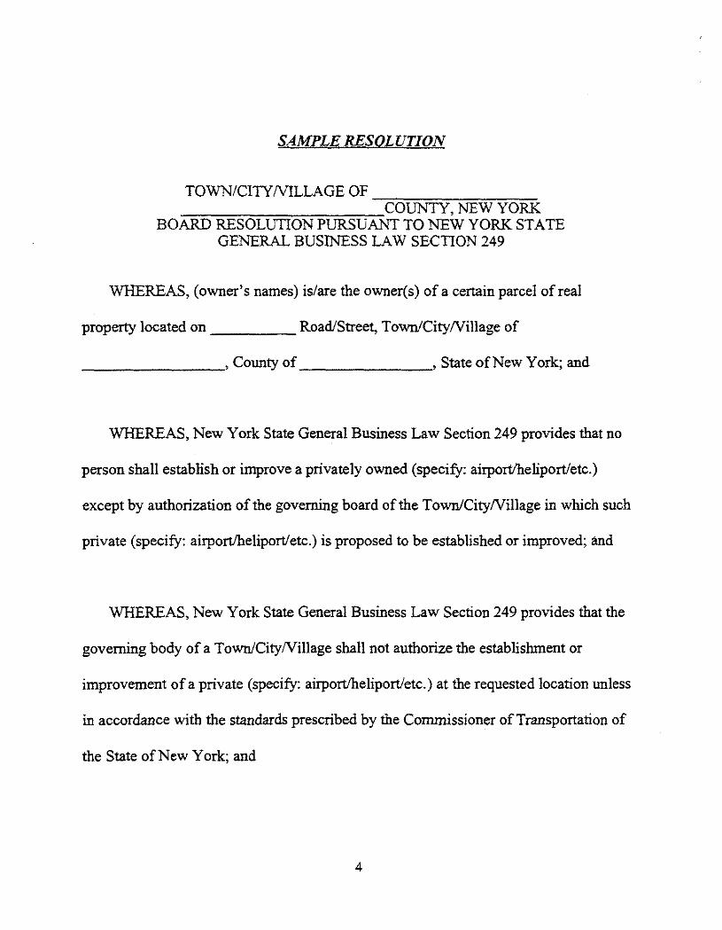
SAMPLE RESOLUTION
TOWN/CITYNILLAGE OF COUNTY, NEW YORK
BOARD RESOLUTION PURSUANT TO NEW YORK STATE GENERAL BUSINESS LAW SECTION 249
WHEREAS, (owner's names) is/are the owner(s) of a certain parcel of real
property located on
Road/Street, Town/CityNillage of
County of
, State of New York; and
WHEREAS, New York State General Business Law Section 249 provides that no
person shall establish or improve a privately owned (specify: airport/heliport/etc .)
except by authorization of the governing board of the Town/CityNillage in which such
private (specify : airport/heliport/etc .) is proposed to be established or improved; and
WHEREAS, New York State General Business Law Section 249 provides that the
governing body of a Town/City/Village shall not authorize the establishment or
improvement of a private (specify : airport/heliport/etc .) at the requested location unless
in accordance with the standards prescribed by the Commissioner of Transportation of
the State of New York; and

WHEREAS, the (specify : airport/heliport/etc .) proposed to be established or
roved will be privately owned and the owner(s) of the real property upon which the
establishment is to take place has (have) consented to such establishment ; and
NOW, THEREFORE, BE IT RESOLVED THAT, the New York State
Commissioner of Transportation is hereby requested to make a determination as to
whether or not the establishment or improvement of such a privately owned (specify :
airport/heliport/etc.) complies with his standards adopted pursuant to Section 249 of the
New York State General Business Law.
DATED:
Seconded by:
Roll Call vote as follows:
(Names with yes/no/abstention or absent)
(Certified copy specified by Town Clerk, etc, with seal required)
AIRPORT CLOSURE NO'f IFICATION
Chapter 478 of the Laws of 1995 (Section 14-h.3 . of the NYS Transportation Law) requires property
aners to notify the New York S' 2 Department of Transportation of their intention to dispose of, sell, _ ease, or otherwise transfer interest in an air transportation facility that would result in such facility no longer being used for aviation purposes. The Department must receive written notice of the proposed transf~- 90 days prior to transfer . Notifications should be forwarded to :
New York State Department of Transportation Aviation Services Bureau 1220 Washington Avenue Albany, NY 12232-0414
When forwarding a notification, we request that all airport tenants be informed of the intended clos-. -e, and that evidence of this notification be provided to us. In addition, the Departme-- should be notified of any change of use.
FAA notification is also required in some instances involving deactivation, abandonment or discontinued use of an airport for . period of one year o- more. These requirements are outlined in FAA Advisory --ircular 70-2E dated
'_9/95 and reporting is accomplished using FAA Form 7-:- 0-1 . Regarding the :
ieral requirement, you should contact the FAA Eastern Region, Airports Division AEA-620, One Aviation Plaza, Springfield Gardens, NY 11434, tel. (718) 553-3341, fax (718) 995-5615 or by e-mail to [email protected] for additional information.

CHAPTER III iPorts
PART 75 Approval of Privately-Owned Airports
Sec. 75.1 Definitions 75.2
Standards presenited by Commissioner of Transportation for approval of privauiy owned airports
753
Documents requited by Commissioner of Transportation for investigation of airport
Historical Note Part (§ 75.1) filed Match 1,1971 ; repealed. new (§§ 75.1-753) filed: ytatcit 29,1974; June
15, 1982 d: Jute 15, 1982.
§ 75.1
Definitions.
PART 75 APPROVAL OF PRIVATELY OWNED AIRPORTS
(Statutory authority: General Business Law, § 249)
For the purposes of this Part, the terms hereinafter listed shall mean as follows: (a)
Landing area.
Any locality, either of land or water, including airports and intermediate landing fields, which is used or intended to be used for the landing and takeoff of aircraft, whether or not &=Ides are provided for shelter, servicing or repair of airGuft or for receiving or urging passengers or cargo.
(b) Airport
Any landing area used regularly by aircraft for receiving or discharging passen-gers or cargo; or for the landing and takeoff of aircraft being used for personal or training p
(c) Airport improvement
The extension, alteration, addition to or realignment of the tun-way(s) of an existing airport, or the modification in any way of the landing or Takeoff directions at such an airport.
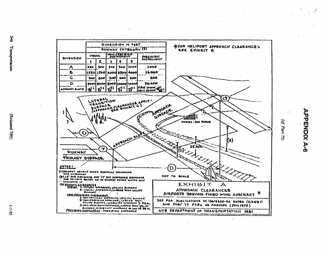
(d) Approach surface
(1)
For airports used by fixed-wing aircraft.
An imaginary plane sloping upward from a point at the same elevation as, and 200 feet from, the appropriate runway end to provide the required clearances above roads, waterways and railroads. (See Exhibit A [Appendix A-6, infra] for applicable approach surface dimensions.)
(2)
For heliports.
An imaginary plane sloping upward from the helipad primary surface to provide the required ciezranees above roads, waterways and railroads. (See Exhibit B [Appendix A-6, infra] for applicable approach surface dimensions .) (e) Approach zone
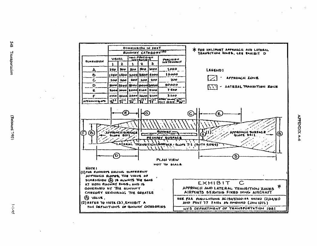
A trapezoidal area formed by the projection of the approach surface onto the ground directly below the approach surface. Approach zone dimensions arc the same as those of the associated approach surface and vary according to runway category, as shown in Exhibit C for airports and Exhibit D for heliports (Appendix A-6, infra) (see 'approach surface", subdivision [d] of this section).
(f)
Primary surface.
That surface which is longitudinally centered on a runway or landing area centerline extending the full length of either side of, and 200 feet beyond the ends of. a runway. It is the same elevation as the nearest point of the runway centerline. The primary surface width will vary according to the runway category (see dimension A on Exhibit A). The primary
1-1-95
(Reissued 7195)
139
Transao,ration

§ 75 .t =LS 17 TRANSPORTATION
surface of a helipad is the overall size of the landing area (see dimensions R & S on Exhibit B) (Appendix A-6.Infra).
(g)
Lateral transition surface.
An area on each side of the primary surface of the runway or landing area and approach surface. The lateral transition surface slopes upward and outward on a seven-tonne plane for airports and a two-to-onc plane for heliports (see Exhibits C and D [Appendix A-b. infra[ for applicable lateral transition surface dimensions for airports and bell-ports. respectively). The same dearanccs apply for lateral transition surfaces as any for ap-proach surfaces (see Exhibits A and B [Appendix A-6. infra[).
(h) Lateral transidon zone
An area on the ground forriaed by the projection of the lateral transition surface onto the ground directly below the lateral transition surface. Lateral transition zone dimensions are the same as those of the associated lateral transition surface and vary according to runway category, as shown in Exhibit C for airports and Exhibit D for heliports (Appendix A-6, infra ) (see "lateral transition surface - , subdivision [.-] of this section) .
(i)
Visual runway.
A runway intended solely for the operation of aircraft using visual approach procedures, with no straight-in instrument approach procedure and no instrument designations . There are two types of visual runways;
(1)
Utility runway.
A runway that is constructed for. and intended to be used by, propel-ler-driven aircraft of 12.500 pounds maximum gross weight and less .
(2)
Larger than utility runway .
A runway that is coasnumed for, and intended to be used by, propeller-driven aircraft of more than 12.500 pounds maximum gross weight, and turbofan and turbojet aircraft . (1 ') Non precision instrumew runway.
A runway having an existing instrument approach procedure utilizing air navigation facilities with only horizontal guidance, or area-type navigation equipment, for which a straight-in, non-precision instrument approach procedure has been ap. proved, or planned, and for which no precision approach facilities are planned, or indicated on an approved FAA planning document.
(k) Precision irurrument runway.
A runway having an existing instrument approach proce. dute utilizing an Instrument Landing System (IL-4). It also means a runway for which a precision approach system is planned and is also indicated on an FAA-approved airport layout plan or any other FAA planning document .
(I)
Insrrmnerrr Landing System (ITS) .
An Instrument Landing System (MS) is a system which provides aircraft the lateral . longitudinal and vertical guidance necessary for a landing.
(in) Aircraft operation.
Either a landing or takeoff by an aircraft. (n)
Aircraft
Any contrivance, now or hereafter invented, for avigation of or flight in the air, except a parachute or other contrivance designed for use as, and carried primarily for, safety equipment.
(1)
Fixed-wing ainTafL
An aircraft, the support of which in the air is normally derived from airfoils that are stationary .
(2)
Helicopter/rotary-wing aircraft
An aircraft. the support of which in the many derived from airfoils mechanically rotated about an"approximately vertical axis.
(3)
Balloon .
An aircraft, the suppon of which in the air-is normally derived from its own buoyancy. (o)
Heliporzlhelipad
An airport used exclusively by helicopters (see " [b] of this section) .
subdivision
(p)
Seaplane operational area.
That part of a body of water on which seaplane operations take place.
(q) Approachldeparrure parts.
The centerline of approach surfaces (see "approach sur-face", subdivision [d] of this section).
H-utorial Note Sec filed March 1 . 1971 ; repealed new filed: March 29,1974; June 13 . 1992 eff. June 15,
1912
nor-
190
Transporation
(Reissued 7/95)
1-1-95

CHAPTER III AIRPORTS AND PARACHUTE JUMPING
§ 75-3
§ 75.2
Standards prescribed by Commissioner of Transpoitation for approval of privately owned airports .
(a)
Primary surfaces, approach zones and Lateral minsition zones shall be dear of all public-owned buildings (see Exhibit C for feed-wing aircraft and Exhibit D for rotary-living ainra8 and balloons (Appendix A-6, infraj).
(b)
For airports used by fixed-wing aircraft. the primary, approach and lateral transition surface-.s for each runway shall be established in a=ordance with the dimensions shown on Exhibits A and C, respectively (Appendix A-6. infra).
(c)
For airports used solely by helicopters or balloons . the primary, approach and lateral transition surfaces shall be established in accordance with the dimensions shown on Exhibits B and D. respectively (Appendix A-6, infra) .
(d)
Primary, approach and lateral transitional surfaces shall maintain the following clear-ances: 17 feet above interstate highways; 15 feet above all other highways ; ?; feet above railroads, and above the highest object which normally traverses waterways.
(e) Favorable airspace determination from the Federal Aviation Administration must be issued and a copy submitted to the commissioner.
(f)
The commissioner may waive any or all of these requirements if his investigation of all factors discloses that the establishment or alteration of a particular airport does not conflict with or affect the safety of public buildings or facilities, or operations on public highways or water-ways, and that the volume. character and direction of traffic at such airport will not constitute a menace to the safety of operations at other airports in the vicinity .
Historical Note Sec filed March 29.1974; repealed, new filed June 15.1982 eff. June 15, 1982 .
§ 75.3
Documents required by Commissioner of Transportation for investigation of airport sites.
(a)
A certified copy of a resolution (or official meeting minutes) duly adopted by the local governing body of the city, village or town in which the airport or any part thereof is proposed to be established or improved, requesting the Commissioner of Transportation to make a determina. tion as to whether or not the establishment or improvement of such a privately owned airport complies with his standards adopted pursuant to section 249 of the General Business Law.
(b)
One USGS topographical map (scale 1.24,000) and one plan view map (scale 1:1.000) with the position of the airport indicated thereon. The airport runways). helipad or seaplane operational area must be plotted thereon accurately. The direction and length of runways and seaplane operational areas must be included on the map. Helipads must be precisely located with the approaehideparmre paths clearly indicated. The map mast be sufficiently large so as to include all approach and lateral transition zones to the airport
(c)
One copy of the favorable airspace determination issued by the Federal Aviation Admin. isrmtion for the proposed airport establishment or improvement
(d)
One copy of the letter from the proponent to the local governing body requesting approval to establish or improve the airport with the following information included :
(1)
name and address of proponent; (2')
the type of aviation activities proposed (aircraft sales and service. flight instruction, crop-4ustin& air taxi. etch
(3)
number of aircraft expected to be based at the (4)
type of aircraft expected to be based at the airport; (5)
whether an instrument approach procedure will be requested for this airport; and (6)
maximum number of daily operations and the anticipated total annual operations . (e)
A statement from the local governing body making the request for such determination that the airport proposed to be established or improved is privately owned. and that all of the owners of
1-1-95
(Reissued 7195)
191
Transpormion
§ 75.3
the real property upon which the establishment or improvement is to take place have consented to such establishment or improvement.
Samrical Nave Sec. filed Mush 29. 2974; repealed. new filial June 15. IM e$ June 15, 2982
TJ2L8I7 TRANSPORTATION
Now
Slt'
." ze'inlp
~t
f~ "7>rr
NOT Tp OGAIC
EX HIt3 " T
A
2)
APPROACI( CIEARAI "ICES AIRP4RT5""9eRVINa FIICHO wING AIRCRIaKT-
SGP. FAA pUW,IGAT.ONS AC Iy0/flDa " 6A OATiO (GJR4Ai) AND PART" 77 FAR, 49 AMRNORD (yAN14T!)
NY9 dQPARTMQNT OF TT(ANSPOR TATtaN 19(1 )
b
A &a"Ne Y G )
/ G ~ VI" YI
,
~~+Pt'
0.gNW hY ARY,3AWFnClL
(UNnN[fr O"!"<T MA'AM N""Waay TMV"wf"1 70 .0 N"111uw"Y fP110' Wlt 4WNyrAYy pNV I1' N" INn""(aC N4iNiV " "Al - ".VI
"P"YS 10M NW4[{T OU"CT w4i<N w wwY '
IT
"vuvMY PkttaQfitR3y IIHDRINAIefT "
mm~ *. ..WAY 3".MN """ft "{ .aN "NF."PfNau "W&,1 f1.NW"7, VNI,Ia1TY N,44W.4 *P V,(,u. . ] "1IOV "fw<"f9I.J "n"<Wi" 1 t1{<fN 4W 4 %Q,,, H W"Y V.% .D " T+ ".n .yIJN " M "av M h!L2!_
1~AHT " Ow "oN.fN A"Lw<d ._._
*FOR NF4IPORT APPROAGN C<.EAReNCEb SHE E><NIbiT B
~- DIM[1i810N "N [,tr RUNWAY CA.TK6OgV tW"..» """
DIMINSION VISUAL
~N. NK~M610 _ "
~tetS I ON 2 2 S N '"tlARNr I
A a 1w "too _ yoo loo to" w~ .1000
D Itlo 1loa 10 lfoo 400 14000
G zoo _Raa _Laa zao goo """ . . . ". " . 200
p foaa Soon loo* 100" too" jaimoo pyM"""w """Oy" _
i 4 "f " " {. . " { MNOTT"00"I ( 1

R t S !MPRRI*"D Af MULTIPLSb CP OV"IIALi. NILICOPTK4 L[NbJN
wiab I
*FOR APPkOACH CLEARANCES AIRPORT5 SCRVINO FIKRD WIN; AIRCRAFT SG6. e.XHIMIT A
tte' RRra
c "Al
(I)N14NRiT RN~*r vwt." NOQIMIA.TTR1VI/tRI6 T+.b %.WRRWAV
II) IS' ~R H~b.JwA`K A.IO V1'ra umn:P.n ulsNvM.Y6 fen M.v~w RM~ W'MNIalmRrOMRS(WRICN AIM t4VR0er IT
EXHlelT 6 11ELIRORT APPROAC14 CLEARANCES
6tt PAA PUOLICATIONS AC 150/5390-16 bATBD (6/22/77) AWE) PART 17 FAR O AS AIAt"UIO (JAN 1978 ) NY6 DIPARTMINT OP TRAN 6PORTATION 1661
CATEGORY R S
PERGONA1. USE 1.5 1.5
PUBLIC USE 2.0 2.0
+itP ~iN~IRLFAtn ~�(iUNWA~
" M"
u PA4 f~ .~/-(~
P IM
'--'-'"
"ALA cM. 41 12AN"ITtON WIRFgLC
ft 7: L ,( 1 T
FOR NI1LIPORY APP"0A4N AUO I.1.'TILgAL TRAN"11'FION . ZON96 . "11 9w11611 P
LtawU1
APpROAGN LONG.
J.ATLRAL M"6IT10N "QE
PLAN VIEW NOT To "t-A48,
NOTLI ((}FOR RUNWAYS NAVtN4 Q1oKla11NT
AFPa0AcN SLOPl4L -run v'"Ut of DIMLNOION AN 14 AI.WAYS '"I( buA" AT balk) 4UNWA'Y RNt1S 1 AND 16
E X H 16 I T
G GOVERNED sty -Big RuawtY
-
APPROAGII AIJD LATERAL TRANSITION ZONES 44 CM940RIREQuMtnk'. 'W6 a¢#ATLR
AIRPORTS 6E RVIN6 FIXHD WING AIRCRAFT ® VALUC,
tint FAA WIULAIlamb AG190/5)00""A u%fwo (A/J .1/UI) (2) Pitfall YO NOTL (3),LIAN161T A
AND PANT 77 FAN" kit AMUNULD (JAN 1M.) N M.I . I
#T1oN4. OF f61NWAY UTnOORiaS
NYC DePARTM&NT OF TRAN%POILTATIDN 1961
OtMCNatoN W FaaT RUNWAY 4ATlaoay
W"UA4 NpMN'rAal"it~oN ~!` K1ou DIMlNlION , 2 1 Z ' IN67pUMlNT
A _b
210 1290
700
iSOO
_SO4)
"am
_two_ _Sip"
140! _4000 r
ibCOO t:00,D . .
_ G D
900
70_00
_74Po
9000
200
_C0_ou _200 _ 100
200
Woo
200
9oooo
! 9002 a0po soap stop flow 1900 . F
AH owltilao! _
a i
yAOO 2"o
HE 1L00 E
1100
~
3100 r. . . Nt~ anl " mo

*Fat AWFOACM AND tA-foltAt. 111ANNTION to"k6 AIRPORT'S 1.ERVINd Fotto W uV AIRCRAFT
Lp,(�eND : Sae "N161T C.
APPROACH LONG
LATERAL T41JUITION SONG.
LATQ"L'1RAH61TIQN 6_URPACe6 " SLDFV' 2:1 (WTM 611xs )
.0=11,
~.
e'''rr INTIOS,
PRI IAARI 4uq A 4oon*
) . r% _I_
4ooo'
R.6 smt ..vse4D Ab NouT
s OF OVCRALS.WI:uboFTRR Lel.~u1'1~.JJ
PLAN View NOT TO ~i4Y
e.x r116 1 T
D APPROACN AND LAT9RAL TRA1451TION ZOUa6
H8LIPOR.TS teat: FAA PUetiCA71o"6 AC 150/5990 " 16 DATED (0/WII
AND PART 77 FART Ao AMENDED (,TAN 1975) fjyS DEPARTMENT OF TRAWSPORTATION M
CA'TH Gony R 6
PaR90NAL Ube 1.6 1.5
PUCiLIC Me 1.0 2.0
Agency Display Of Estimated Burden For Notice of Landing Area Proposal The public report burden for this collection of information is estimated to average 45 minutes per response.
u wish to comment on the accuracy of the estimate or make suggestions for reducing this burden, please direct your comments to OMB and the FAA at the following addresses :
Office of Management and Budget Paperwork Reduction Project 2120-0036 Washington, D.C . 20503
U.S . Department of Transportation, Federal Aviation Administration irspace and Obstruction Evaluation Branch, ATP-240
800 Independence Avenue, S.W. Washington, D.C. 20591
INSTRUCTIONS NOTICE OF LANDING AREA PROPOSAL
As Used Herein, The Term "Airport" Means Any Landing or Takeoff Area such as Airport, Heliport, Helistop, Vertiport, Gliderport, Seaplane Base,
Uitralight Flightpark, or Balloonport
Federal Aviation Regulations Part 157 requires all persons to notify the FAA at least 90 days before any construction, alteration, activation, deactivation, or change to the status or use of a civil or joint-use (civil/military) airport . Notice is not required for the establishment of a temporary airport at which operations will be conducted under visual flight rules (VFR) and will be used for less than 30 days with no more than 10 operations per day . Notice also is not required for the intermittent use of a site that is not an established airport, which is used for less than one year and at which flight operations will be conducted only under VFR. Intermittent use means the use of the site for no more than 3 days in any one week and for no more than 10 operations per day.
Required notice shall be submitted on this form from each person who intends to do any of the following : 1 . Construct or otherwise establish a new airport or activate an airport. 2. Construct, realign, alter, or activate any runway, or other aircraft landing or takeoff area of an airport. 3 . Construct realign, alter, or activate a taxiway associated with a landing or takeoff area on a public-use airport. 4 . Deactivate, discontinue using, or abandon an airport or any landing or takeoff area of an airport for a period of one
year or more. 5 . Deactivate, abandon, or discontinue using a taxiway associated with a landing or takeoff area on a public-use
airport . 6. Change the status of an airport from private use (use by the owner or use by the owner and other persons authorized
by the owner) to an airport open to the public or from public-use to another status. 7. Change status from IFR to VFR or VFR to IM 8. Establish or change any traffic pattern or traffic pattern altitude or direction.
The notice required shall be made by submitting this form to the nearest Federal Aviation Administration Regional Office or Airports District Office . However, in an emergency involving essential public service or when the relay arising from the 90-day advance notice requirement would result in an unreasonable hardship, you may provide notice to the appropriate FAA Airports District/Field Office by telephone in lieu of submitting this form . The FAA may require the subsequent submission of this form when necessary for safety or other reasons .
Section 901 of the Federal Aviation Act of 1958, as amended, provides that any person who violates a rule, regulation or order issued under Title III of this Act shall be subject to a civil penalty not to exceed S 1,000 for each violation .
1. For any project falling in categories 1, or 2 above, complete all appropriate sections. 2. For any project falling in categories 3, 4, or 5 above, complete sections A, B, D (if appropriate), and I . 3. For status change (categories 6 or 7 above), from private use to public use or from VFR to IFR, complete sections
A, B, E, G, and I . For all other changes, complete sections A, B, and I. 4. For traffic pattern establishment or change (category 8) complete all appropriate sections . Traffic pattern
description should be entered on the reverse side of FAA Form 7480-1 . 5. Express all bearings as magnetic and mileages as nautical . 6 . Please Print or Type All Items.
Section A - Identify Reference Datum of Coo
GENERAL INSTRUCTIONS
ates (NAD 83 or NAD 27)
Section B - If the airport is to be used by the owner only, or by the owner and persons authorized by the owner, check "private" . If the landing and takeoff area of the airport is publicly owned and the operator is a non-government entity, then check "private use of public lands" . If the airport is to be available for use by the general public without a requirement for prior approval of the owner or operator, then check "public" . If necessary, use the reverse side of the form or a separate sheet of paper to describe changes or alterations. Section C - Airport or seaplane base : List VFR airports and heliportsw within 5NM, and IFR airports within 20NM. Heliports: List VFR airports and heliports within 3NM and IFRairports within IONM.
Section D - Attach U.S. Geological Survey quadrangle map or equivalent . Plot locations of facility to the nearest second, runway alignments, associated taxiways or sealane alignments . When appropriate, use city map for heliports.
Section E - List and plot on quadrangle map or equivalent any obstructions within : 3NM of a VFR airport or a seaplane base ; 5NM of an IFR airport; or 5,000 feet of a heliport . Section F - Self-explanatory . Section G - List schools, churches and residential communities within a 2NM radius for airports and within a 1 NM radius for heliports . List all waste disposal sites within a 5NM radius . Section H - Self-explanatory.
Notification to the FAA does not waive the requirements of any other government agency.
ADDRESSES OF THE REGIONAL OFFICES Submit your completed form by mail to the regional Airports Division office. For airports in New York State ONLY, that address is
FAA Eastern Regional Office Airports Division AEA-620 One Aviation Plaza Springfield Gardens, NY 11434 Tel . 718-553-3341 Fax: 718-995-5615 e-mail : [email protected]
Addresses for other regions can be obtained at h_Ptt :IJwww.faa.govlarplace/address .htm
FAA Form 7480.1 (1-93) Supersedes Previous Edition
C" rom ayon Ei"ararc rtwrsbn wACE.es (iartn, 20M)
Form approved OMB No . 2120-0036
D.$"o "p,mn .ntorTransaonae«~ NOTICE OF LANDING AREA PROPOSAL r~"wrai Avudon Abnimeaaaa Name of Proponent Individual, or orga=
QCheck if the property owners name and address are different than above, and fist property owners name and address or the reverse .
Address of Proponent, Individual , or Organization (No., Street, City, State, Lip Code)
a Activation Deactivation or abandonment Airport Ultraflight Fiightpark Vertipot _ Establishment Q
} Atteration Q Change of Status OF Q Helipot Q Seaplane Base Q other (Specify)
A . Location of Landiria Area t" Associated City/State 2 . County/State (Physical Location of Airport)
_ =3 and Drrecbor From
City a Twm 1 1lrr
TYPe U Q Public Q Private Q Private Use of Public LandtWaters
-(f Change of Status Or Alteration, "be Change u Cons truction ate$ Establishment a To 9egmfBegan Est ConpIeaon change to vaffic pattern (Describe on reverse)
Ref. A5 above 0 . Landin Area Data Pro Direction Distance - - - " . is - R" n'^'Y
C. Other Landing Areas L= Area
) FArea
Landing Magnetic Bearing of Runway (s) or Seelane
Runway (s) a Seatane (s) ~'-
unwaY (s) or Sealane (s) '....-
Asphalt, surface
Etc.) ~-
. . " = ns of Final Approach and
a (FATO) in Feet
I
of Touchdown and " " ea (TLOF) in Feet
Direction of tngnessiEgress
. : Crete, rooftop, etc.) MEN Descnpban of Lighting (If any) Direction of Prorating Wind
" " - -_tionaI Data rted a Actual Number Based Aircraft
"
~ . tense
Present (Kesi. indicate e by leftr'E7
afed 5 5 Years Hence
_ port Ptea
(Nest.indicale
dkate bybtter'E7
ed 5 S year Years Hence
G . OtherConsideratioits Direction
Identification Landing Area
Landing Area
3. Are IFR Procedures For The Airport Anticipated Q No Q Yes Within Years Type Navafd: H. Application for Airpon Licensing
Has Been Made Not Required [) County Q Wdl Be Made State Q Municipal Authority
1. CERTIFICATION : I hereby certify that ad of the above statements made by me are true and complete to the best of my - _ Name. tine (and address if dferent titan above) of person Sing this notice - type a print
Signahae Im ink)
Date of Signature Telephone No . (Precede with area code)